
Submitted:
02 November 2025
Posted:
03 November 2025
You are already at the latest version
Abstract
The aim of this article is to illustrate the actions for the implementation of the River Contract. This is an inclusive and voluntary tool for strategic and negotiated planning, whose main purpose is the protection and better management of water resources, the enhancement of the river ecosystem and the mitigation of flood risk, contributing to local development. In this case, the little river basin is located in central Italy. Proposing actions means being able to respond to the environmental and territorial problems of this area, integrating and coordinating existing plans and programs with the interests of the territory. These actions were defined through a participatory process involving citizens, professionals, administrators and stakeholders. The proposed actions focused on those offering “sustainable” solutions to certain critical issues of the river, such as pollution or the anthropogenic threat and the conservation of riparian habitats. These habitats, protected by the Natura 2000 network, are home to fish species of great conservation interest. Finally, flood mitigation works and measures are assessed, as flooding is becoming increasingly aggressive due to climate change and is impacting urbanised areas. All these actions were compared with sustainability goals to highlight their effectiveness in the current management of a river basin with a view to the future.
Keywords:
river basin
; river contract
; nature 2000 network
; action programme
; sustainability development goals
; central Italy
1. Introduction
A river basin is an area that collects all the precipitation that flows, directly and through tributaries, into its riverbed. This water plays an important role in the hydrological cycle, as it moves across the surface and can be used by all living beings [1,2,3]. Within the basin, however, its flow depends strictly on the development of the altimetry. It decreases more or less gradually from the upper to the lower sections, determining quite different morphological, hydrological, vegetation and land use characteristics. These characteristics can also vary over time and therefore no longer be fully consistent with current conditions. This lack of consistency is increasingly linked to the impact of human activities on the environment [4,5,6]. This is why the management of a river basin is complex, as it does not always succeed in integrating naturalistic, landscape and socio-economic values. Furthermore, in terms of organisation and control, the overlapping of different levels of responsibility can limit its exercise [7,8]. This has led to conflicts over the use of water resources, habitat conservation and even flooding. Increased vulnerability has also weakened the relationship between populations and this territory and the wealth of knowledge and experience that has grown up around it. Indeed, it could even be said that many citizens have little perception or awareness of the value of water [9,10].
To reverse this trend, the River Contract could be proposed: a voluntary-based inclusive tool for strategic and negotiated planning, whose main scope is the protection and better management of water resources, the enhancement of river landscapes and the mitigation of flood risk, contributing to local development [11,12]. Its introduction in Europe has shown its effectiveness in improving the objectives set. In particular, these objectives include a number of priorities regulated by specific EU legislation [13,14,15] concerning the prevention and reduction of pollution, the sustainable use of water, the protection of the environment and aquatic ecosystems, and the reduction of flood and drought risk [16,17].
In reality, prototype experiences of river contracts developed in France as early as the 1980s, and then subsequently in Belgium, Luxembourg and the Netherlands [12,18,19]. It should be noted that in France and Belgium, it was mainly educational aspects that mobilised local communities, as they found inconsistencies in the conditions of rivers and the quality of the water flowing in them. In order to raise awareness of river issues and activate decisions on the actions to be taken, “contracts de rivière” were proposed. It should be emphasised that the actions of these contracts, especially those in Wallonia in Belgium [20], sought solutions to problems through specific studies consistent with the characteristics of the location. Among the advantages of these contracts were the effective information campaign and joint discussion to build a participatory river culture and the integration of sectoral policies for activities that had an impact on the territory.
These lessons have been helpful for the Italian experiences of the River Contract in a river area [12,21,22]. However, the adoption of the contract in Italy makes it possible to coordinate actions and interventions relating to the implementation of the aforementioned regulations and to ensure their consistency. Respect is also shown for plans and programmes already developed for the area in question, especially those that directly affect water bodies. Its implementation cannot be separated from the sharing between public and private entities of a document of intent that contains the reasons for intervening not only on the objectives of the EU directives, but also the specific critical issues that prevent that river basin from effectively protecting water resources with a view to sustainable development i.e., [23,24,25]. While critical issues are often in the news, in-depth knowledge of environmental, social and economic aspects and the relationships between them is sometimes neglected. For this reason, in order to reacquire an identity that has grown up around that territory and define the extremes of adaptation and enhancement, it is necessary to commit to this phase. However, this is not enough because every human action carried out in a river basin should involve a set of complex choices that maintain a balance between the different levels of responsibility involved. Furthermore, in order to be effective, such action must take into account not only the natural, landscape and socio-economic values of that territory, but also the rules underlying these values [26,27].
Ensuring this integration is not always easy, nor is it immediately applicable in some cases. For this reason, the River Contract tool can represent a solution, or rather an extraordinary opportunity for development for any territory crossed by a watercourse, regardless of its size. The chances of success are very high, as every action, from its definition to its implementation, will involve citizens, including organised groups, professionals, administrators and stakeholders, all motivated to resolve the environmental and territorial issues emerging in what is considered their home territory. Therefore, being able to directly witness the definition and implementation of responses within a well-defined and limited time frame can bring each of these individuals closer to the river, for which they will all feel responsible. Furthermore, sharing decisions at a local level can “raise” the value of water as a resource and make it possible to pay greater attention to its use for the well-being of people and the protection of the environment [28,29].
This specific aspiration, which we could say is one of the main motivations behind the River Contract, is in line with the objectives defined by the United Nations as a strategy “to achieve a better and more sustainable future for all” [30]. Motivations must be consistently followed by actions that reflect the benefits linking human well-being and the health of natural systems to sustainable development i.e., [31,32,33,34]. This assessment has been verified in the actions agreed upon in the Rio Capodacqua – Santa Croce River Contract in Central Italy. Due to its limited size, this verification may be easier to highlight, however, any impacts on the water body could be further emphasised with repercussions on water quality and quantity and on the natural system.
2. Rio Capodacqua - Santa Croce Basin
The Rio Capodacqua - Santa Croce river basin is located in central Italy, more precisely between the Aurunci Mountains, Mesozoic limestone hills belonging to the Apennine chain, and the Tyrrhenian Sea, where the main river flows into. Its main sources are at 87 m above sea level on the slopes of the aforementioned mountains, from where the waters flow for almost 11 km to the mouth. The basin covers over 35 sq km and involves three municipalities: Formia, Minturno and Spigno Saturnia in the Lazio Region. Although the upper parts of the basin are over 1,000 m above sea level, it mostly extends within the Quaternary alluvial deposits of a coastal plain [35] (Figure 1).
The tributaries of the main river, close to the western hills, dissect clays with gypsum and conglomerates (Upper Miocene and Pliocene), as well as debris slopes and alluvial cones (Quaternary). To the east, however, the watershed of the basin is located on the tops of hills consisting of densely stratified sandstones and pelites (Middle-Upper Miocene). These deposits cover a limestone succession (Jurassic-Cretaceous), almost identical to that of the major reliefs to the west [36]. In reality, this structure highlights how the wide valley separating the limestone sequences, thousands of metres thick, masks a significant overthrust that occurred during the compressive phases of the Apennine chain in the Upper Miocene [37]. Following the uplift of the chain, the marginal areas were lowered with the formation of coastal plains, where most of the investigated basin developed. This context was further disrupted during the Quaternary by much milder tectonic phases and then shaped by morphodynamic agents triggered by climatic conditions [38].
The climate of these areas is classified as semi-continental in the mountains (although the temperature rarely drops below 0 and it only snows on the peaks for a few days each winter) and Mediterranean, with hot summers and mild winters, on the plains. However, limiting the data to the latter over the last twenty years (downloaded from [39] for the weather stations of Formia and Minturno), the average annual temperatures range between 9° and 13° for the minimum and around 22°-23° for the maximum. Average annual rainfall is just over 1100 mm, reaching its maximum mainly in the autumn months, while there is a noticeable dry spell in the summer months. The windiness in the basin is mainly represented by winds coming from the south with moderate intensity (<16 km/h). As far as extreme phenomena are concerned, it should be noted that high temperatures (>10 days) are increasingly frequent in the summer months (especially August) with temperatures above 27° and peaks of over 40° especially in the eastern areas of the basin. The coldest periods are mainly recorded in January and February, with the most significant sub-zero peaks occurring in the western areas. In terms of abnormal rainfall events, those just below 150 mm in 2005 and 2019 are noteworthy.
The Capodacqua stream, as the main watercourse in the upper section is called, is fed by several karst springs located in the locality of the same name [40,41]. These springs guarantee a flow rate ranging from a maximum of 2,500 to 500 litres per second during the dry season, with a water temperature at the source of 12.5°C, which characterises them as “cold waters”. The water from these springs is almost entirely collected for the drinking water supply of neighbouring villages by an organisation that manages the water collection and distribution systems for approximately 32,700 users. Only a small amount of spring water is released to maintain the flow rates of the upper course of the Rio Capodacqua-S. Croce. This residual flow is sufficient to ensure a significant flow even during the summer low water period. The latter is also increased by modest water sources located at lower altitudes in the eastern part of the basin in Santa Croce. These sources feed a tributary, which then flows into the main river, giving it its compound name. A further flow of the watercourse is also due to the groundwater table at the bottom of the valley. The tributaries of the Rio Capodacqua - Santa Croce are temporary watercourses characterised by long summer dry spells. In some cases, it is also possible that discharges are allowed to flow into them, maintaining a temporary artificial flow, even for most of the summer period. According to the monitoring carried out in the waters flowing in the main river [42], over the last ten years, the chemical status has remained consistently good, while the ecological status tends to fluctuate between good and sufficient. This fluctuation is likely due to sensitivity to the conditions prevailing along the watercourse.
According to surveys carried out (see [43]), the main characteristic of both the Rio Capodacqua-Santa Croce riverbeds and its main tributaries is that they have a moderately deep riverbed with a substantially stable course over the last century. In fact, the layout of the current main hydrographic network does not differ from that shown on the IGM map at a scale of 1: 25,000, which dates back to the first half of the 20th century. In general, the only differences consist of the accentuation of some bends along the main course, but these are very modest retreats, with shifts in the banks of no more than twenty metres in almost a hundred years. In addition, there is a limited tendency for the bottom profile to lower in places, mitigated by the proximity of the sea level. In fact, especially on the Rio Santa Croce section, the banks often have a very steep, if not vertical, first slope from bottom to top, 0.5-1 m high, mostly dug into silty-sandy deposits, with no vegetation. Above this, there is usually the actual bank, 2 to 4 m high, less sloping and secured by riparian vegetation. In this context, therefore, vegetated floodplains have not been able to develop and sandbars are also very rare, being present mainly at the most pronounced bends, i.e. in the same areas where the banks have undergone the most significant evolution. It is therefore clear that the processes of bank retreat are very slow, even where they are not counteracted by recent or ancient bank defences. The latter consist mainly of walls leaning against the bank, which in places emerge from the riparian vegetation, without however making it possible to define their exact layout with certainty.
This river is included in the Natura 2000 network, with the code SCI IT6040024 (Table 1 and Table 2), due to the presence of riparian habitats typical of Mediterranean watercourses and, above all, the presence of fish species of great conservation interest (i.e. Lampreda planeri, Rutilus rubilio, Salmo (trutta) macrostigma) [44].
Among the vegetation associations, those with a high presence of hygrophilous species stand out, mainly phytocenoses dominated by white poplar (Populus alba) in codominance with white willow (Salix alba), and a sparse presence of hazel (Corylus avellana), elm (Ulmus minor) and black poplar (Populus nigra). Some of these areas are also characterised by the presence of narrow-leaved ash (Fraxinus oxycarpa) and laurel (Laurus nobilis), which represent the remnants of the vegetation on the slopes that descend towards the watercourses and are now found in narrow strips along the banks. About a decade ago, the species Salmo (trutta) macrostigma was present in the Rio Capodacqua-Santa Croce, but now seems to have disappeared. This is due to hybridisation with the currently widespread alien species Salmo (trutta) trutta. In addition to the presence of alien species, the main threats to habitats are essentially due to anthropogenic pressure, which is concentrated in the lower part of the basin to the point of directly interfering with the watercourse. In its upper part, almost the entire basin is covered by vegetation, with the exception of some areas used for agriculture (olive groves and arable land) and those occupied by small, scattered settlements along the primary and secondary road network [45].
The regional parks located to the north and south of the Rio Capodacqua-Santa Croce basin offer further protection to this area (Figure 1). In particular, the Monti Aurunci Park protects the western areas upstream of the basin [46] and therefore the buffer zone of the Capodacqua spring. Instead, the north-western boundary of the Gianola and Scauri Mount Park (managed by the Riviera di Ulisse Regional Park Authority) borders the last stretch of the main river [47], including its mouth, and some “residential” hamlets in the municipality of Formia. For this reason, the inhabitants of these hamlets could enjoy the proximity to an area of greater natural value and tourist attraction, as well as raise awareness of the river.
The population of the municipalities affected by the river basin amounts to almost 60,000 inhabitants, most of whom live and work outside the basin (see urbanised areas in Figure 1). The exception is the population of Spigno Saturnia (2,837 inhabitants), which resides almost entirely within the basin and is mainly engaged in activities located there [48]. However, mobility data indicate that the roads crossing the river basin carry a significant volume of traffic in both the east-west and north-south directions. This population is part of an economic system developed mainly in the productive sectors such as agriculture and crafts, tourism, trade and services.
More specifically, agricultural businesses represent a significant share of the local economy based on the development of typical agricultural products, the recovery of inland areas such as the Monti Aurunci, and the promotion of the area for tourism purposes. The latter exploits the areas of particular natural beauty scattered throughout the region. Among these, however, coastal areas have attracted a greater number of tourists in recent years, leading to the need to build a large number of accommodation facilities (e.g. hotels, holiday homes, camping sites) [49].
3. Development of the River Contract
In order to assess the sustainability of actions that could strengthen the management of the River Contract, the methods that led to its development were analysed. (Figure 2) However, it was necessary to take into account the planning tools already in place for the territory covered by the Contract, as well as the phases that allowed for the consolidation of the Contract's implementation and the definition of actions [50,51]. For this reason, it was initially possible to share a common interest in the river area, where water flows, which is important in terms of quality and quantity for the well-being of life and which is home to valuable habitats but can also be a source of fear due to the possibility of flooding. In this scenario, it was crucial to find ideas for bringing together public and private entities willing to contribute to improving those altered or threatened conditions, to the point of contributing to local development. The improvement had to necessarily verify compliance with the obligations arising from the implementation of EU directives and the directives that stemmed from them. For this River Contract, the municipalities of Formia, Minturno and Spigno Saturnia, part of whose territory falls within the Rio Capodacqua-Santa Croce basin, were immediately involved as public partners. This involvement is due to the fact that their urban planning instruments directly affect the actions of the Contract [52,53,54].
Furthermore, in their role, they can be advocates for funding requests for actions such as those concerning urban regeneration. Also considered among the public partners were the park management bodies, which carry out control tasks in the areas adjacent to the basin and, in the case of the Gianola and Scauri Mount Regional Park, are responsible for the management and monitoring of the ecosystem falling within the SCI/SPA area [44]. Public bodies considered included both the managing body of the Integrated Water Service and the body responsible for resources for industrial consortia. The former is responsible for managing the water service in the area, well beyond the municipalities of the Basin, with reference to the Water Framework Directive [14]. More specifically, in an area larger than the basin under study, this company guarantees the qualitative and quantitative control of the water supplied and treated, the monitoring of the facilities, including the Capodacqua spring, transparency towards users and their participation in improving the quality of the service. The second, in addition to maintaining the water balance for the operation of the industrial site located between the upper and lower sections of the watercourse, should ensure that treated water is released in accordance with the limits set by the National Law [55]. In addition to these public partners, who are responsible for implementing European, national and regional regulations, there are also citizens who have an interest in that river area, both as individuals and as associations. Among the latter, it should be noted that one of these associations, which is also dedicated to assessing water quality at river mouths at national level, triggered the idea of the River Contract for the Rio Capodacqua-Santa Croce. This approach, which makes it possible to involve grassroots actors, is the original one, but contracts can also be drawn up that start from the promotion of institutions. [21,22,51,56].
The cognitive analysis of the environmental, social and economic aspects of the territory covered by the River Contract has certainly highlighted the state of the places. This state, in addition to being explored in depth by technical-scientific and statistical studies, has been refined by a series of public meetings held throughout the territory. Among other things, these meetings have made it possible to learn about aspects that were not entirely known, as well as to update people's perception of the natural aspects of the basin [57]. This has resulted in greater inclusion in the decision-making process and, therefore, better acceptance of the transformative practices envisaged in the Strategic Plan. Therefore, this document highlights the critical issues present in various areas and the shared strategies considered optimal for resolving them, while identifying the partner responsible for implementing the River Contract. However, in the next phase, each partner involved is expected to continue to monitor the development and effectiveness of the actions. Among other things, the Contract provides for widespread information, both through a specific web page and on the various institutional websites of the stakeholders responsible for the actions. More specifically, the Strategic Document analysed the pressures and impacts exerted by human activity on the water bodies comprising the entire basin [58]. This led to the identification and brief description of the interventions or measures capable of achieving the objectives of the Contract. The implementing entities, whether public, private or in the form of partnerships, responsible for carrying out each individual intervention or implementing the measures were also indicated. Most of the entities, based on the financial requirements necessary for the feasibility of the various actions, have identified possible sources of funding, while the rest have already taken steps to secure sources of financing. Due to uncertainties regarding the sources and timing of the funds available to cover the requirements, it has not been possible to draw up a schedule with timelines for the implementation of each individual intervention and measure. In practice, the Strategic Plan defines the broad guidelines on which the Action Programme will be based. Such a Programme therefore organises the actions and measures to be adopted according to strategic axes aimed at solving the critical issues that have emerged in the area, with a view to assessing their sustainability. This will be a way to verify the efficiency of the participatory process carried out using the River Contract tool.
However, at present, the documents produced are awaiting approval by the regional bodies. These bodies will have to verify their consistency with the provisions of the legislation and the current plans already in place and being implemented. Based on the Contracts already evaluated, the Programme will be considered consistent if it has paid particular attention to aspects related to the safety of the territory and the achievement of at least a good quality status for water bodies.
4. Contract Actions
The Action Programme is primarily an operational tool, as it contains the actions (tangible and intangible projects) that determine the achievement of the objectives of the River Contract, with particular attention to interventions that contribute to the achievement of the environmental quality objectives set by current regulations [17,19,59,60]. More specifically, the directives that are considered fundamental, including for obtaining funding, are:
- European Council Directive 43/92/EEC on the conservation of natural habitats [13],
- Directive 2000/60/EC of the European Parliament and of the Council establishing a framework for Community action in the field of water policy [14],
- Directive 2007/60/EC of the European Parliament and of the Council on the assessment and management of flood risks [15],
- Part III of Legislative Decree No. 152 of 3 April 2006 (Environmental Regulations) [51].
However, it was felt that in order to make the actions set out in the Plan more effective, it was necessary to address the critical issues highlighted in the Strategic Document and the strategies indicated to resolve them, which were the result of the participatory process. In fact, these strategies emphasise the important role of actors operating in the local and administrative sphere, because through them it is easier to define the feasibility of actions, which can be modelled according to needs. The more the various stakeholders can be involved, the more it will be possible to create a network in which the different actors will be willing to engage in dialogue to pursue objectives aimed at the redevelopment of river areas. In some cases, Nature-Based solutions have been proposed, also exploiting an interdisciplinary approach and the active participation of the local community [61,62].
In order to be more concrete, an attempt has been made to group the 26 actions recognised and supported by various partners according to the main strategic axes represented by water quality, environmental enhancement, including the anthropic aspect, flood defence and the promotion and development of the territory covered by the River Contract. For each of these areas, a number of activities are presented here aimed at resolving the critical issues highlighted or developing opportunities.
The strategic axis that triggered the intentions of the River Contract is probably represented by water quality, which the actions should resolve by reducing pollution. Unfortunately, in recent years, the quality data have not been encouraging, so it is necessary, indeed essential, to resort to a series of actions capable of reversing the trend of deteriorating water quality in the Rio Capodacqua-Santa Croce. This trend, verified by monitoring, is demonstrated not so much by assessments of the ecological and chemical status [42], but by microbiological assessments, especially in the lower reaches of the watercourse. Furthermore, at least in the last five years, this situation has been highlighted by the decidedly negative values of the samples taken at its mouth (heavily polluted) during the annual campaigns to check the bathing suitability of the waters. However, analyses of the watercourse show exceedances of the limit values (see Annex 5, Table 3 in [55]) for both dissolved oxygen (>75%) and Escherichia coli (>5,000 CFU/100ml). These values are indicative of organic pollution linked to contamination from human or animal biological residues [63]. In this case, such contamination could be attributed to the lack of adequate purification systems in the middle part of the watercourse (e.g. the industrial area located there) (Figure 3). In addition to this cause, there are also numerous effluents from buildings, and even from recent residential complexes, located in the lower reaches of the river or in the sub-basins flowing into it, which use purification systems that are unsuitable or inadequate for the number of equivalent inhabitants, which is rather complex to estimate. Therefore, the first actions were aimed at more careful and frequent monitoring of river waters [64,65]. This is the responsibility of the public water management authority for this area, but in recent years, the voluntary contribution of secondary school students has been considered useful and effective in this action. They would even be willing to increase their curricular activities by placing sensors in the watercourse to be monitored remotely, so as to promptly highlight any contamination [66,67]. Of course, direct or indirect introduction into the water body must also be linked to unauthorised discharges. Such discharges should not only be stopped, but if necessary, as is the case for some new urban agglomerations, improved and incorporated into the sewerage systems of the municipalities of Spigno Saturnia, Minturno and Formia. Different solutions should be implemented for effluents that cannot be authorised or are not directly perceptible. As has been highlighted, within the river basin under consideration, most of the land is used for agriculture (Lazio Region) (Figure 3), therefore, a further contribution to pollution could depend on the use of chemicals in agricultural practices. In this sense, buffer strips could be adopted to prevent the spread of these substances [68]. Similarly, action should be taken on water coming from the road network, which heavily interferes with the hydrographic network. (Figure 3) For these last two actions, regional companies dealing with agriculture and road networks at regional level have been involved in seeking specific funding for the proposed interventions. Finally, another important aspect is to activate purification systems on a widespread basis to combat the discharge of untreated water from the regional consortium's craft and industrial activities and from “small” users who still use unsuitable systems.
Finally, it should be noted that while water quality could affect the health of all living beings, the quantity flowing in the Rio Capodacqua-Santa Croce is becoming a threat to the fish species present. In fact, although the flow of water at the main source has always been significant, with climate change and increased demand for water, the situation often becomes very critical during periods of low water flow. Therefore, the protection of the habitat with all the species present is a commitment that must be maintained, as the watercourse is part of the Natura 2000 network [44]. The management of this site is the responsibility of the Gianola and Scauri Mount Regional Park, but it will be those who manage the water resource and supply drinking water to this area who will also have to take responsibility for it. This managing body cannot fail to consider the amount of water in the river that guarantees life (Minimum Vital Flow) [69]. (Figure 4a) This guarantee could, in fact, form the basis for one of the actions included in the other strategic axis, concerning environmental enhancement, namely the restoration of the specific characteristics of the Rio Capodacqua - Santa Croce. In particular, the management and maintenance of riparian vegetation communities and floodplain areas (Figure 4b) should allow the target species present along the watercourse to maintain their optimal condition, especially those of high conservation interest or threatened with extinction [44]. Among the recommended activities, which the Gianola and Scauri Mount Regional Park has committed to carrying out, are the census, containment and eradication of alien and/or invasive plant and animal species, as well as the repopulation of the Salmo (trutta) macrostigma species in the Rio Capodacqua-Santa Croce SCI with genetically selected material from the regional fish breeding centre.
In the renaturalisation process, it is important to ensure the stability of the banks through innovative, “environmentally friendly” techniques, such as those of naturalistic engineering [70,71]. The use of these techniques is being studied and developed by a well-established Italian and foreign team, which includes another higher education institute in the area. This institute could contribute to studying and then intervening in all those cases where the slope could be undermined at the base or eroded at the top. All this could be carried out through an information campaign in the area with the help of various associations and schools, which will be able to rediscover the richness of the river environment.
When discussing the enhancement of the river environment, it is quite natural to also consider the quality of the source and mouth environments, which are the responsibility of the public water management authority for this area and the partnership between the Municipality of Formia and the Riviera di Ulisse Regional Park Authority, respectively. These represent the most significant hydrological elements for a watercourse, on which the identity of the watercourse can be recovered. More specifically, the Capodacqua spring is important for its nature and value as a water resource in the area (Figure 5a). Its capture for drinking water dates back to Roman times, when it was built to supply neighbouring towns. What remains of Roman construction at the spring, as well as other historical hydraulic works (springs, fountains, mills, wells, ditches, etc.) scattered throughout the basin, should be restored or brought back to a usable state, in order to include them in an educational programme aimed at highlighting the attention paid to this resource since ancient times [72].
The urban area near the mouth of the river could also be reorganised to improve the usability of the adjacent areas. Those on the right-hand side are particularly crowded in the summer months, as they are adjacent to the waterfront and therefore to some of the sandy beaches belonging to the municipality of Formia. Its peripheral location has penalised the urbanisation system, which is not always consistent, and its liveability in terms of services and flood protection. The left side of the mouth, on the other hand, belongs to the Gianola and Scauri Mount Regional Park. This condition is not noticeable at all, were it not for the presence of some Roman ruins visible among the vegetation. Moreover, it would be important to postpone a possible access to the Park area to those who frequent the mouth of the Rio Capodacqua-Santa Croce (Figure 5b). Among the sites still linked to water, despite their current poor condition, a project has been launched to reclaim and renaturalise small lakes in the foothills of the Aurunci Mountains. Once excavated to mine gypsum, which is still visible but no longer extractable, in the future they could become small wetlands, thereby increasing the environmental and landscape value of these places. The project, already carried out by technicians commissioned by the Municipality of Formia, could find funding within the framework of regional projects, also in view of the inclusion of the site among the regional geological assets [72].
Reducing the risk of flooding is the aim of another strategic axis through actions that may fall within other activities already described for the other strategic axes [73]. For example, caring for riparian areas by reforesting them or consolidating embankments using natural engineering techniques are valid measures. However, unlike other strategic axes, for flood defence, there is a project by the Province of Latina [74], that has intervened to resolve the critical issue that worries many who live or work around the lower stretch of the Rio Capodacqua-Santa Croce: flooding that damages structures and infrastructure located on the embankments and even in the floodplain areas. The project certainly includes a series of activities such as water level containment structures consisting of new embankments, especially near urbanised areas, the hydraulic adaptation of crossing infrastructure (bridges, culverts, etc.) on the lower reaches of the watercourse and its tributaries, and the creation of flood control areas, which should not be further delayed. Here too, the reference to climate change cannot be ignored. However, the reduction of hydraulic risk must also be measured against less demanding interventions such as the cleaning of ditches, canals and streams on private property, or the maintenance of the banks and buffer zones of the river and its tributaries by the public bodies that perform this role. Particular attention has been paid to interference caused by road, rail and plant crossings with watercourses in the river basin [75]. These can be critical for water flow, especially during floods, but also for the redevelopment of embankments. In fact, as can be seen from the Rio Capodacqua-Santa Croce Flood Map (Figure 6), there appears to be a direct relationship between anthropogenic impact and the areas where the greatest consequences have been observed [77,78].
One emergency that frequently attracts the attention of the inhabitants of the Aurunci area and beyond is fires. Those who have studied the fight against forest fires are concerned about the destabilisation of the rock mass on the slopes resulting from the loss of resistance provided by the root systems, i.e. the alteration of riparian and floodplain ecosystems due to the disappearance of the canopy or ground litter. Responsibility for this emergency situation, especially in summer, is shared between the regional parks and the municipalities concerned.
Finally, the River Contract aims to develop actions to promote and develop the territory (examples in Active Citizenship and Valorisation [56]. This last strategic axis could activate actions capable of bringing the river to life, consolidating the identity of the Rio Capodacqua – Santa Croce. The creation of nature trails and/or sports and/or sensory trails along the banks with areas dedicated to leisure activities could certainly be one way of implementing this action, as could the installation of educational signage providing information on the natural, artistic and cultural beauty of the river and its surroundings, which would help to raise awareness among local and non-local visitors. While this action could be entrusted to the Gianola and Scauri Mount Regional Park as part of its direct responsibility for the SCI [44], it is also believed that associations and municipalities could create opportunities for young people who are passionate about the beauty of their local area, to the point of wanting to promote it.
Another aspect that should not be overlooked is the promotion of sustainable agriculture, including through the launch of training courses for young people on the most effective agricultural practices in the current context. This action could strengthen the small-scale initiatives already underway in the basin. Furthermore, it could raise awareness that only careful and appropriate care can make land cultivation sustainable, which is threatened by climatic events and the easy use of chemical additives on soil or crops. These agricultural products, as well as the restaurants that use them, could promote the brand of the Rio Capodacqua – Santa Croce River Contract. This brand could be promoted in all sustainable businesses that actively operate in the river basin. Finally, there is a strategic desire to promote the ‘River Contract for Children and Young People’ see [56], in order to immediately instil in them a passion for the river by developing and implementing environmental education projects suitable for them. This section may be divided by subheadings. It should provide a concise and precise description of the experimental results, their interpretation, as well as the experimental conclusions that can be drawn.
5. Sustainability of actions
An essential step in understanding the sustainability of each action is the assignment of specific objectives in reference to those proposed by the UN to be achieved by 2030 [78]. Most of the 17 goals could enable the River Contract to be included in a virtuous cycle, making all its actions potentially sustainable [32,33,34] (Figure 7). To this end, the targets of the Sustainable Development Goals will be made operational, assessing the relevance of certain indicators, albeit qualitative, [79] relevant to the situations that can be verified in the Rio Capodacqua-Santa Croce basin.
More specifically, the sustainability of actions aimed at ensuring water quality for all through careful management is manifold (goal 6: Clean water and sanitation). These actions are primarily aimed at improving the health and well-being of the inhabitants and the ecosystem, not only of this water basin (goals 3 and 15: Good health and well-being and Life on land). In fact, reducing pollution, represented by contaminants dispersed in the watercourse, could also affect the coastal waters of the Gulf of Gaeta, whose beaches adjacent to the mouth of the Rio Capodacqua-Santa Croce have been considered unsuitable for swimming for several years. The quest to avoid all forms of waste and contamination in our daily lives would also be a goal to achieve, so as to ensure a sustainable water access service for our communities and cities (goals 6 and 11: Clean water and sanitation). Specific measures such as the elimination of uncontrolled discharges, the reduction of chemical releases and the halving of untreated wastewater would be commitments to be made consciously and participatively [80]. This form of respect would lead to more responsible water use, taking into account the prospect of exacerbated climate anomalies. Furthermore, the preservation and protection of recognised river habitats and species still present would benefit if specific practices were implemented, such as those proposed in line with the obligations arising from international agreements (Natura 2000 network sites). In these activities, in addition to re-naturalizing the ecosystem and reconstituting the riparian vegetation [81], it will be important to significantly reduce the impact of invasive alien species [82] and the repopulation of native species that have practically disappeared (goal 15: Life on land).
Naturally, the proposed actions, the result of active participation, will be effective if they respect the cooperation of the various partners involved for the common good (Goal 17: Partnership for the goals). Therefore, some of the actions envisaged under this axis, beyond the necessary economic resources, could be undertaken by activating goodwill for the greater good and a future to be ensured for future generations. So far, reference has been made to the enhancement of the river environment and the sustainability of their actions aimed at restoring the specific characteristics of a water landscape. However, it cannot be overlooked that the Rio Capodacqua-Santa Croce has represented an identifying feature since the past. Indeed, the restoration of the hydraulic condition and distribution systems within the basin also contributes to educating, especially among younger generations, about water conservation and protection [83], as the United Nations targets themselves advocate.
However, while actions related to the first two strategic axes aim to implement a system that can contribute to improving environmental conditions, actions related to reducing flood risks can contribute to making settlements and human activities safer (goal 11: Sustainable cities and communities). This protection should be present during the design and planning phase, since the danger of a watercourse is known or foreseeable; unfortunately, it is sometimes disregarded, with serious consequences. However, these risks, including those of the Rio Capodacqua-Santa Croce, appear to have increased due to the increased frequency of anomalous rainfall events. Adapting to these different climatic conditions is necessary (goal 13: Climate action) to prevent flood damage from becoming unbearable for a community and its territory [84].
Finally, there are some actions under the "promotion and development" strategic axis that allow for the promotion of quality education, employment, economic growth, and even new forms of clean energy (goals 4, 7, and 8: Quality education, Affordable and clean energy and Decent work and economic growth). Indeed, the involvement of some higher education institutions in river-related activities (water monitoring and bioengineering techniques for riparian zones), as well as the promotion of water-related educational and recreational activities, can increase young people's knowledge [85,86]. This knowledge could even provide them with the technical and professional skills to pursue jobs that benefit the region. The development of "environmentally friendly" agriculture, which could create new jobs and development in the region, also fits into this direction. Being environmentally friendly means developing resilient agricultural practices that help preserve the ecosystem and strengthen the capacity to adapt to climate change [87]. This action could give strength to some small, virtuous efforts already underway in the basin and increase productivity. This will help spread the cultivation of healthy organic produce and foster a local "zero kilometer" market (Goal 12: Responsible consumption and production).
This could be said to be in addition to the actions included in the program to be implemented for the Rio Capodacqua-Santa Croce Contract, a reality that has already manifested itself in its lower reaches. The creation of a Renewable Energy Community, hoped for to improve the way clean energy is consumed and produced within the basin (Goal 7: Affordable and Clean energy), has certainly confirmed the effectiveness of the participatory tool [88]. The involvement of public and private entities, some of which support the River Contract, believed in this initiative and quickly supported its implementation. They obtained funding and are now beginning to "build" it as a community. Contributing together to change is a way of understanding sustainability. It is expected that all the Plan's actions will replicate what is happening with the Energy Community, which focuses on the protection, proper management of resources, and the enhancement of riverine areas, along with protection from hydraulic risks, thus contributing to local development.
6. Conclusions
The introduction of River Contracts to manage a region increasingly suffering from inadequate protection and management of water resources should be considered a turning point. Indeed, due to past errors, water quality has been shown to be inadequate to ensure the health and well-being of residents and the animal and plant species present. While the former resulted in restrictions on water use, the latter increased the risk of affecting the IUCN Red List [89], which includes species at risk of extinction (see the annexes to Directive "Habitats" [13]). These situations, also highlighted in the Rio Capodacqua-Santa Croce basin, have also been compounded by the effects of flooding. These effects are primarily attributed to the aggressiveness of climate change, rather than to inadequate maintenance, failure to respect flood zones, and therefore to excessive human pressure for a watercourse. Faced with these situations, even the river basin under examination has experienced a shift away from perceiving the river, in its various components, as a resource for development. This condition has erased what history has taught us, even around a small watercourse like the Rio Capodacqua-Santa Croce. However, the River Contract activated in its basin may have changed public perception. The involvement of public and private entities around a common goal: protecting and improving the management of water resources, striving to enhance the river ecosystem and mitigate flood risk, may have been a decidedly positive moment. This shift has also been observed in other similar processes, to the point of allowing them to be called "Smart Rivers" [90,91,92,93]. This expression, defined by OECD [94] as "an enabler of innovation, as much as being an innovation itself", referred more to the digital approach to river monitoring than to the direct involvement of public and private entities [95,96]. Sharing the goals for the Rio Capodacqua-Santa Croce has allowed us to recognize critical issues that have negative consequences on the territory. Increased awareness has made it possible to identify strategically sustainable actions, as verified among the objectives of the 2030 Agenda. Responsibility for the implementation of these actions has been identified in public entities capable of securing funding, however it will be the responsibility of the entire community to ensure that this occurs within the expected timeframe. In conclusion, the River Contract activates a participatory process between communities and stakeholders, capable of establishing and pursuing objectives for the sustainable management of water resources [16,50,51]. Indeed, ensuring water supply and water quality means preserving the integrity of the ecosystem, even in conditions of difficult-to-sustain climate change. Furthermore, it allows for greater determination and pragmatism in addressing the best solutions to overcome a region's critical issues. Therefore, the "River Contract" tool ensures the necessary sustainability for future generations.
Author Contributions
Conceptualization, A.V.; writing—original draft preparation, A.V.; investigation, C.F.;writing—review and editing, A.V., C.F.; supervision, A.V. Both authors have read and agree to the published version of the manuscript.
Funding
This research received no external funding.
Acknowledgments
The authors are grateful to the Technical-Scientific Group that led the River Contract process of Rio Capodacqua-Santa Croce for its willingness to provide the information and material needed for this contribution.
Conflicts of Interest
The authors declare no conflict of interest.
References
- Newson, M. Land, Water, and Development: Sustainable Management of River Basin Systems, 2nd ed. Routledge, London, 1997.
- Molle, F.; Wester, P.; Hirsch, P. River basin development and management. In: Molden, D. (Ed.), Water for Food-Water for Life. Comprehensive Assessment of Water Management in Agriculture. EarthScan, London, 2007, 585–624.
- Keller, A.A.; Garner, K.; Rao, N.; Knipping, E.; Thomas, J. Hydrological models for climate-based assessments at the watershed scale: a critical review of existing hydrologic and water quality models. Sci. Total Environ. 2023, 867, 161209. [CrossRef]
- Marston, R.A; Girel, J.; Pautou, G., Piegay, H.; Bravard, J.P.; Arneson, C., Channel metamorphosis, floodplain disturbance, and vegetation development: Ain River, France. In Biogeomorphology, Terrestrial and Freshwater Systems, C.R. Hupp, W.R. Osterkamp, A.D. Howard, Editors, Elsevier, 1995, 121-131. [CrossRef]
- Hooke J.M., Human impacts on fluvial systems in the Mediterranean region, Geomorphology 2006, 79, 3–4, 311-335. [CrossRef]
- Knights, A.M.; Koss, R.S.; Robinson, L.A. Identifying common pressure pathways from a complex network of human activities to support ecosystem-based management. Ecol. Appl. 2013, 23, 755–765. [CrossRef]
- Molle, F. Water, politics and river basin governance: repoliticizing approaches to river basin management, Water International 2009, 34, 1, 62-70. [CrossRef]
- Gardon, F.R. Land Prioritization: An Approach to the Effective Environmental Planning of Hydrographic Basins. Environmental Management 2021, 67, 623–631. [CrossRef]
- Seelen, L. M. S.; Flaim, G.; Jennings, E. De Senerpont Domis, L. N. Saving water for the future: Public awareness of water usage and water quality. J. Environ. Plan. Manag 2019, 242, 246-257. [CrossRef]
- Petino, G. Accordi sull’uso dell’acqua, cooperazione, politiche e conflitti: i contratti di fiume in Italia e il ruolo del geomediatore. Documenti Geografici 2024, 1, 145-166. [CrossRef]
- La Jeunesse, I.; Rounsevell, M.; Vanclooster, M. Delivering a decision support system tool to a river contract: a way to implement the participatory approach principle at the catchment scale? Physics and Chemistry of the Earth 2003, 28, 547–554. [CrossRef]
- Bastiani, M. Contratti di fiume. Pianificazione strategica e partecipata dei bacini idrografici. Dario Flaccovio Editore, 2011.
- Council of the European Union, Directive 92/43/EEC on the conservation of natural habitats and of wild fauna and flora, Official Journal of the European Communities, L 206, 22.07.1992, 7-50.
- European Parliament and Council, Directive 2000/60/EC establishing a framework for community action in the field of water policy, L 327, 22.12.2000, 25.
- European Parliament and Council, Directive 2007/60/EC on the assessment and management of flood risks, Official Journal of the European Union, L 288, 6.11.2007, 27–34.
- Jager, N.W.; Challies, E.; Kochskämper, E.; Newig, J.; Benson, D.; Blackstock, K.; Collins, K.; Ernst, A.; Evers, M.; Feichtinger, J.; Fritsch, O; Gooch, G.; Grund, W.; Hedelin, B.; Hernández-Mora, N., Hüesker, F., Huitema D., Irvine, K.; Klinke A.; Lange, L.; Loupsans D.; Lubell, M.; Maganda C.; Matczak, P.; Parés M.; Saarikoski H.; Slavíková L.; Van der Arend S.; Von Korff, Y. Transforming European Water Governance? Participation and River Basin Management under the EU Water Framework Directive in 13 Member States. Water 2016, 8, 156. [CrossRef]
- Muccitelli, S.; Pozzi, C.; D’Ascanio, R.; Magaudda, S. Environmental Contract: A Collaborative Tool to Improve the Multilevel Governance of European MPAs. Sustainability 2023, 15, 8174. [CrossRef]
- Brun, A., Les contrats de rivière en France: enjeux, acteurs et territoires. Les Cahiers de droit, 2010, 51(3-4), 679–704. [CrossRef]
- Scaduto, M.L. River Contracts and Integrated Water Management in Europe; UNIPA Springer Series; Springer International Publishing: Cham, Switzerland, 2016, 15–70.
- Rosillon, F. Eau et territoire à travers l’expérience des contrats de rivière en Wallonie (Belgique). Territoire en movement 2015, 25-26. [CrossRef]
- Voghera, A. The River agreement in Italy. Resilient Planning for the co-evolution of communities and landscapes. Land Use Policy 2020, 91, 104377.
- Venturini, F.; Visentin, F. River contracts in north-east Italy: Water management or participatory processes? The Geographical Journal, 2024, 190(2), e12473. [CrossRef]
- Kundzewicz, Z.W. Water resources for sustainable development, Hydrological Sciences Journal, 1997, 42(4), 467-480. [CrossRef]
- Kiedrzyńska, E.; Kiedrzyński, M.; Zalewski, M., Sustainable floodplain management for flood prevention and water quality improvement. Nat. Hazards 2015, 76, 955. [CrossRef]
- Li, P.; Wu, J. Water Resources and Sustainable Development. Water 2024, 16, 134. [CrossRef]
- Wiering, M.; Immink, I. When Water Management Meets Spatial Planning: A Policy-Arrangements Perspective. Environment and Planning C: Government and Policy 2006, 24(3), 423-438. [CrossRef]
- Vallerani, F.; Visentin F. Waterways and the Cultural Landscapes, London, Routledge, 2018.
- Jackson, R.B.; Carpenter, S.R.; Dahm, C.N.; McKnight, D.M.; Naiman, R.J.; Postel, S.L.; Running, S.W. Water in a changing world. Ecol. Appl. 2001, 11, 1027–1045. [CrossRef]
- Pahl-Wostl, C.; Palmer, M.; Richards, K. Enhancing water security for the benefits of humans and nature—the role of governance. Current Opinion in Environmental Sustainability, 2013, 5(6), 676-684. [CrossRef]
- UN General Assembly. Transforming our world: the 2030 Agenda for Sustainable Development; Resolution: A/70/L.1, 2015.
- Weststrate, J.; Dijkstra, G.; Eshuis, J.; Gianoli, A.; Rusca, M. The sustainable development goal on water and sanitation: learning from the millennium development goals. Social Indicators Research 2019, 143(2), 795-810.
- Ge, Y.; Li, X.; Cai, X.; Deng, X.; Wu, F.; Li, Z.; Luan, W. Converting UN Sustainable Development Goals (SDGs) to Decision-Making Objectives and Implementation Options at the River Basin Scale. Sustainability 2018, 10, 1056. [CrossRef]
- Di Baldassarre, G.; Sivapalan, M.; Rusca, M.; Cudennec, C.; Garcia, M.; Kreibich, H.; Konar, M.; Mondino, E.; Mård, J.; Pande, S.; Sanderson, M.R.; Tian F.; Viglione, A.; Wei, J.; Wei, Y.; Yu, D.J.; Srinivasan, V.; Blöschlet, G. Sociohydrology: Scientific Challenges in Addressing the Sustainable Development Goals. Water Resour. Res. 2019, 55, 6327–6355. [CrossRef]
- Couto, E.V.d.; Oliveira, P.B.; Vieira, L.M.; Schmitz, M.H.; Ferreira, J.H.D. Integrating Environmental, Geographical and Social Data to Assess Sustainability in Hydrographic Basins: The ESI Approach. Sustainability 2020, 12, 3057. [CrossRef]
- Regione Lazio, Piano di tutela delle acque (aggiornato) con allegati, 2018.
- Cipollari, P.; Cosentino, D. Considerazioni sulla strutturazione della catena dei Monti Aurunci: Vincoli stratigrafici. Studi Geol. Camerti 1991, 2, 151–156.
- Rossi, D.; Bigi, S.; Del Castello, M.; Di Manna, P. The structure of the Aurunci Mountains (southern Lazio): a balanced cross-section and its restoration. Boll. Soc. Geol. It. 2002, Volume Speciale n. 1, 151–159.
- Corrado, G.; Donadio, C.; Pennetta, M.; Schiattarella, M.; Valente, A. Pliocene to Quaternary morphotectonic evolution of the Gaeta Bay, Tyrrhenian coastal belt, central Italy: A review. Quaternary International 2022, 638-639, 111-121. [CrossRef]
- Regione Lazio https://www.siarl-lazio.it/ (accessed on 20 October 2025).
- Sappa, G.; Ergul, S.; Ferranti, F. Water quality assessment of carbonate aquifers in southern Latium region, Central Italy: a case study for irrigation and drinking purposes. Appl Water Sci, 2014, 4, 115–128. [CrossRef]
- Sappa, G.; De Filippi, F.M.; Iacurto, S.; Grelle, G. Evaluation of Minimum Karst Spring Discharge Using a Simple Rainfall-Input Model: The Case Study of Capodacqua di Spigno Spring (Central Italy). Water 2019, 11, 807. [CrossRef]
- Arpa Lazio https://www.arpalazio.it/ambiente/acqua/dati-acqua (accessed on 20 October 2025).
- Rinaldi, M.; Surian, N.; Comiti, F.; Bussettini, M. A Method for the Assessment and Analysis of the Hydromorphological Condition of Italian Streams: The Morphological Quality Index (MQI). Geomorphology 2013, 180–181, 96–108. [CrossRef]
- Calvario, E.; Sarrocco, S.; Scagliusi, E.; Bardi, A. Piano di gestione dei siti Natura 2000 Promontorio di Gianola e Monte di Scauri (SIC-ZPS IT6040023) e Rio S. Croce (SIC IT 6040024). Documento di sintesi. Edizioni ARP Agenzia Regionale Parchi, 2007, Roma.
- Regione Lazio, https://geoportale.regione.lazio.it/layers/geosdiownr:geonode:a__2000_carta_uso_suolo (accessed on 20 October 2025).
- Parco Regionale dei Monti Aurunci, https://www.parcoaurunci.it/ (accessed on 20 October 2025).
- Parco Regionale della Riviera di Ulisse, https://www.parchilazio.it/rivieradiulisse (accessed on 20 October 2025).
- Urbistat, https://ugeo.urbistat.com/adminstat/it/it/demografia/dati-sintesi/lazio/12/2 (accessed on 20 October 2025).
- Regione Lazio, https://statistica.regione.lazio.it/statistica/it/lazio-in-numeri/mercato-del-lavoro (accessed on 20 October 2025).
- Fasoli, E.; Bastiani, M.; Puma, F. Public participation in the implementation in Italy of the Water-Related Directives. In Water law, policy and economics in Italy: Between national autonomy and EU Law constraints, Turrini, P.; Massarutto, A.; Pertile, M., De Carli, A. (Eds.). Springer International Publishing, 2021, 461-483.
- Bastiani, M.; Bianco, A.; Conte, G.; Gusmaroli, G. L’approccio win-win nei Contratti di Fiume. Integrazione a scala locale delle politiche di gestione dei corpi idrici attraverso la partecipazione. Progetto CReIAMO PA, 2022.
- Geneletti, D. Reasons and options for integrating ecosystem services in strategic environmental assessment of spatial planning. International Journal of Biodiversity Science, Ecosystem Services & Management 2011, 7(3), 143–149. [CrossRef]
- Cialdea, D.; Cacucci, S. The River's contract: An opportunity for new landscape planning activities. International Journal of Design & Nature and Ecodynamics 2017, 12, 314-323. [CrossRef]
- Zoppi, C. Ecosystem Services, Green Infrastructure and Spatial Planning. Sustainability 2020, 12, 4396. [CrossRef]
- ISPRA https://www.isprambiente.gov.it/it/garante_aia_ilva/normativa/normativa-ambientale/Dlgs_152_06 _TestoUnicoAmbientale.pdf (accessed on 20 October 2025).
- Rossi, F. Method and Practice for Integrated Water Landscapes Management: River Contracts for Resilient Territories and Communities Facing Climate Change. Urban Sci. 2022, 6, 83. [CrossRef]
- Pascual, U.; Balvanera, P.; Díaz, S.; Pataki, G.; Roth, E.; Stenseke, M.; Watson, R.T.; BaşakDessane, E.; Islar, M.; Kelemen, E.; Maris, V.; Quaas, M.; Subramanian, S.M.; Wittmer,H.; Adlan, A.; Ahn, S.; Al-Hafedh, Y.S.; Amankwah, E.; Asah, S.T.; Berry, P.; Bilgin, A.; Breslow, S.J.; Bullock, C.; Cáceres, D.; Daly-Hassen, H.; Figueroa, E.; Golden, C.D.; Gómez-Baggethun, E.; González-Jiménez, D.; Houdet, J.; Keune, H.; Kumar, R.; Ma, K.; May, P.H.; Mead, A.; O'Farrell, P.; Pandit, R.; Pengue, W.; Pichis-Madruga, R.; Popa, F.; Preston, S.; Pacheco-Balanza, D.; Saarikoski, H.; Strassburg, B.B.; van den Belt, M.; Verma, M.; Wickson, F.; Yagi, N., Valuing nature's contributions to people: the IPBES approach. Curr. Opin. Environ. Sustain., 2017, 26–27, 7–16. http://dx. [CrossRef]
- Grizzetti, B.; Pistocchi, A.; Liquete, C.; Udias, A.; Bouraoui, F.; van de Bund, W. Human Pressures and Ecological Status of European Rivers. Sci. Rep. 2017, 7, 205. [CrossRef]
- Moss, T. The governance of land use in river basins: prospects for overcoming problems of institutional interplay with the EU Water Framework Directive, Land Use Policy 2004, 21, 1, 85-94.
- Cialdea, D.; Pompei, C. An overview of the River Contract tool: new aims in planning and protected areas issues. European Planning Studies 2022, 30, 4, 684-704. [CrossRef]
- Albert, C.; Hack, J.; Schmidt, S.; Schröter, B. Planning and governing nature-based solutions in river landscapes: Concepts, cases, and insights, Ambio Springer 2021, 1405-1413.
- Conte, A.; Brunetti, P.; Allevato, E.; Stazi, S.R.; Antenozio, M.L.; Passatore, L.; Cardarelli, M. Nature Based Solutions on the river environment: An example of cross-disciplinary sustainable management, with local community active participation and visual art as science transfer tool. J. Environ. Plan. Manag. 2023, 66, 2388–2405. [CrossRef]
- Some, S.; Mondal, R.; Mitra, D.; Jain, D.; Verma, D.; Das S. Microbial pollution of water with special reference to coliform bacteria and their nexus with environment, Energy Nexus 2021, 1, 100008. [CrossRef]
- Behmel, S.; Damour, M.; Ludwig, R.; Rodriguez, M.J. Water quality monitoring strategies - A review and future perspectives, Sci. Total Environ. 2016, 571, 1312-1329. [CrossRef]
- Forio, M.A.E.; Goethals, P.L.M. An Integrated Approach of Multi-Community Monitoring and Assessment of Aquatic Ecosystems to Support Sustainable Development. Sustainability 2020, 12, 5603. [CrossRef]
- Le Dinh, T.; Hu, W.; Sikka, P.; Corke P.; Overs, L.; Brosnan, S. Design and deployment of a remote robust sensor network: experiences from an outdoor water quality monitoring network. In: 32nd IEEE Conference on Local Computer Networks (LCN 2007), Dublin, Ireland, October 2007, 799–806.
- Adu-Manu, K.S.; Katsriku, F.A.; Abdulai, J.; Engmann, F. Smart river monitoring using wireless sensor networks. Wirel. Commun. Mob. Comput. 2020, 1–19. [CrossRef]
- Dosskey, M.G.; Vidon, P.; Gurwick, N.P.; Allan, C.J.; Duval, T.P.; Lowrance, R., The role of riparian vegetation in protecting and improving chemical water quality in streams. J. Am. Water Resour. Assoc. 2010, 46, 261–277. [CrossRef]
- Petitguyot T, Schmidt G, Bussettini M, Linsen M, Arqued-Esquía VM, Smolar-Žvanut N, Alves MH, TheodoropoulosC, Skoulikidis N, Hernandez-Herrero E, Sanchez-Navarro R, Tanner K, Ureta-Maeso J. Ecological flows in the implementation of the Water Framework Directive. In: EU Water Framework Directive (WFD), Common Implementation Strategy (CIS) Guidance Document nº31. Brussel, 2015.
- Lilli, M.A.; Nerantzaki, S.D.; Riziotis, C.; Kotronakis, M.; Efstathiou, D.; Kontakos, D.; Lymberakis, P.; Avramakis, M.; Tsakirakis, A.; Protopapadakis, K.; Nikolaidis, N.P. Vision-Based Decision-Making Methodology for Riparian Forest Restoration and Flood Protection Using Nature-Based Solutions. Sustainability 2020, 12, 3305. [CrossRef]
- Masiero, M.; Bottaro, G.; Righetti, C.; Nikolaidis, N.P.; Lilli, M.A.; Pettenella, D. Riparian Forests as Nature-Based Solutions within the Mediterranean Context: A Biophysical and Economic Assessment for the Koiliaris RiverWatershed (Crete, Greece). Forests 2024, 15, 760. [CrossRef]
- Casto L. I beni culturali a carattere geologico del Lazio. I Monti Lepini, Ausoni ed Aurunci. Ed. Regione Lazio, 2005.
- European Environment Agency, Flood risks and environmental vulnerability: exploring the synergies between floodplain restoration, water policies and thematic policies, EEA Report, No 1, 2016 https://www.eea.europa.eu/publications/floodrisks-and-environmental-vulnerability.
- Provincia di Latina, Progettazione definitiva degli Interventi di Riqualificazione Idraulica e Ambientale del Rio Santa Croce nei comuni di Formia e Minturno, 2012.
- Blanton P., Marcus W.A., Railroads, roads and lateral disconnection in the river landscapes of the continental United States, Geomorphology, 2009, 112, Issues 3–4, 212-227. [CrossRef]
- Zhou, Q.; Leng, G.; Su, J.; Ren, Y. Comparison of urbanization and climate change impacts on urban flood volumes: Importance of urban planning and drainage adaptation. Sci. Total Environ. 2019, 658, 24–33. [CrossRef]
- Faccini, F.; Luino, F.; Paliaga, G.; Roccati, A.; Turconi, L. Flash Flood Events along the West Mediterranean Coasts: Inundations of Urbanized Areas Conditioned by Anthropic Impacts. Land 2021, 10, 620. [CrossRef]
- United Nations. Sustainable Development Goals. Department of Economic and Social Affairs, United Nations. 2015. Available online: https://www.un.org/sustainabledevelopment/sustainable-development-goals/ (accessed on 20 October 2025).
- Hák Tomáš, Janoušková Svatava, Moldan Bedřich, Sustainable Development Goals: A need for relevant indicators. Ecological Indicators 2016, 60, 565-573. [CrossRef]
- Malinauskaite, J.; Delpech, B.; Montorsi, L.; Venturelli, M.; Gernjak, W.; Abily, M.; Stepišnik Perdih, T.; Nyktari, E.; Jouhara, H. Wastewater Reuse in the EU and Southern European Countries: Policies, Barriers and Good Practices. Sustainability 2024, 16, 11277. [CrossRef]
- Petitjean, M.; Peiffer, E.;Michez, A.; Gousenbourger, P.-Y.;Pétrossians, R.; Houbrechts, G.;Guffens, C.; Soares-Frazão, S. Identification of Key Metrics for Quality Assessment of Small-River Restoration Projects from Publicly Available Sources and Field Data in Wallonia. Water 2025, 17, 2564. [CrossRef]
- Strayer, D. L. Alien species in fresh waters: Ecological effects, interactions with other stressors, and prospects for the future. Freshwater Biology 2010, 55, 152–174.
- Venckute, M.; Silva, M.M.; Figueiredo, M. Education as a tool to reduce the water footprint of young people. Millenium 2017, 2,101–111.
- Auliagisni, W.; Wilkinson, S.; Elkharboutly, M. Learning from Floods—How a Community Develops Future Resilience. Water 2022, 14, 3238. [CrossRef]
- Karleuša, B.; Deluka-Tibljaš A.; Ožanić N.; Ilić S. The Role of Higher Education in Developing Awareness about Water Management. International Symposium on Water Management and Hydraulic Engineering Ohrid/Macedonia, 1-5 September 2009, Paper: A17.
- Dean, A.J.; Fielding, K.S., Newton, F.J. Community Knowledge about Water: Who Has Better Knowledge and Is This Associated with Water-Related Behaviors and Support for Water-Related Policies? PLoS ONE 2016, 11(7), e0159063. [CrossRef]
- Bastiani, M.; Venerucci, V.; Rizzuto, P. Progetti di Comunità: Contratti di Fiume, Green Community e Comunità energetiche rinnovabili. In: Rapporto dal Territorio 2022 – Istituto Nazionale di Urbanistica, 2023.
- Sawicka, B. Resilient Agricultural Practices. In Leal Filho, W., Azul, A., Brandli, L., Özuyar, P., Wall, T. (eds) Zero Hunger. Encyclopedia of the UN Sustainable Development Goals. Springer, Cham, 2019. [CrossRef]
- Blasi, C.; Zavattero, L.; Capotorti, G.; Bonacquisti, S.; Copiz, R.; Del Vico E.; Facioni, L.. Lista Rossa degli Ecosistemi d’Italia. Comitato Italiano IUCN, Ministero dell’Ambiente e della Sicurezza Energetica, 2023.
- Ramos, H. M.; McNabola, A.; López-Jiménez, P.A., Pérez-Sánchez, M. Smart water management towards future water sustainable networks. Water 2019, 12(1), 58. [CrossRef]
- Gourbesville, P.; Ma, Q. Smart river management: What is next? River 2022, 1, 37–46. [CrossRef]
- Owen, D. L. Smart water management. River 2023, 2, 21–29. [CrossRef]
- Olatunde, T.M.; Adelani, F.A.; Sikhakhane, Z.Q. A Review of Smart Water Management Systems from Africa and the United States. Engineering Science & Technology Journal, 2024, 5 (4), 1231-42. [CrossRef]
- Organisation for Economic Co-operation and Development (OECD). Policies to support smart water systems. Lessons learnt from countries experience. ENV/EPOC/WPBWE (2012) 6. OECD, Paris, France, 2012.
- Palermo, S.A.; Maiolo, M.; Brusco, A.C.; Turco, M.; Pirouz, B.; Greco, E.; Spezzano, G.; Piro, P. Smart Technologies for Water Resource Management: An Overview, Sensors 2022, 22, 6225. [CrossRef]
Figure 1.
The Rio Capodacqua-Santa Croce Basin on DTM. This sketch shows the municipalities within the basin and the two Regional Parks partially affected by this area. Some of the main levels of the Corine Land Cover 2018 are also indicated.
Figure 1.
The Rio Capodacqua-Santa Croce Basin on DTM. This sketch shows the municipalities within the basin and the two Regional Parks partially affected by this area. Some of the main levels of the Corine Land Cover 2018 are also indicated.
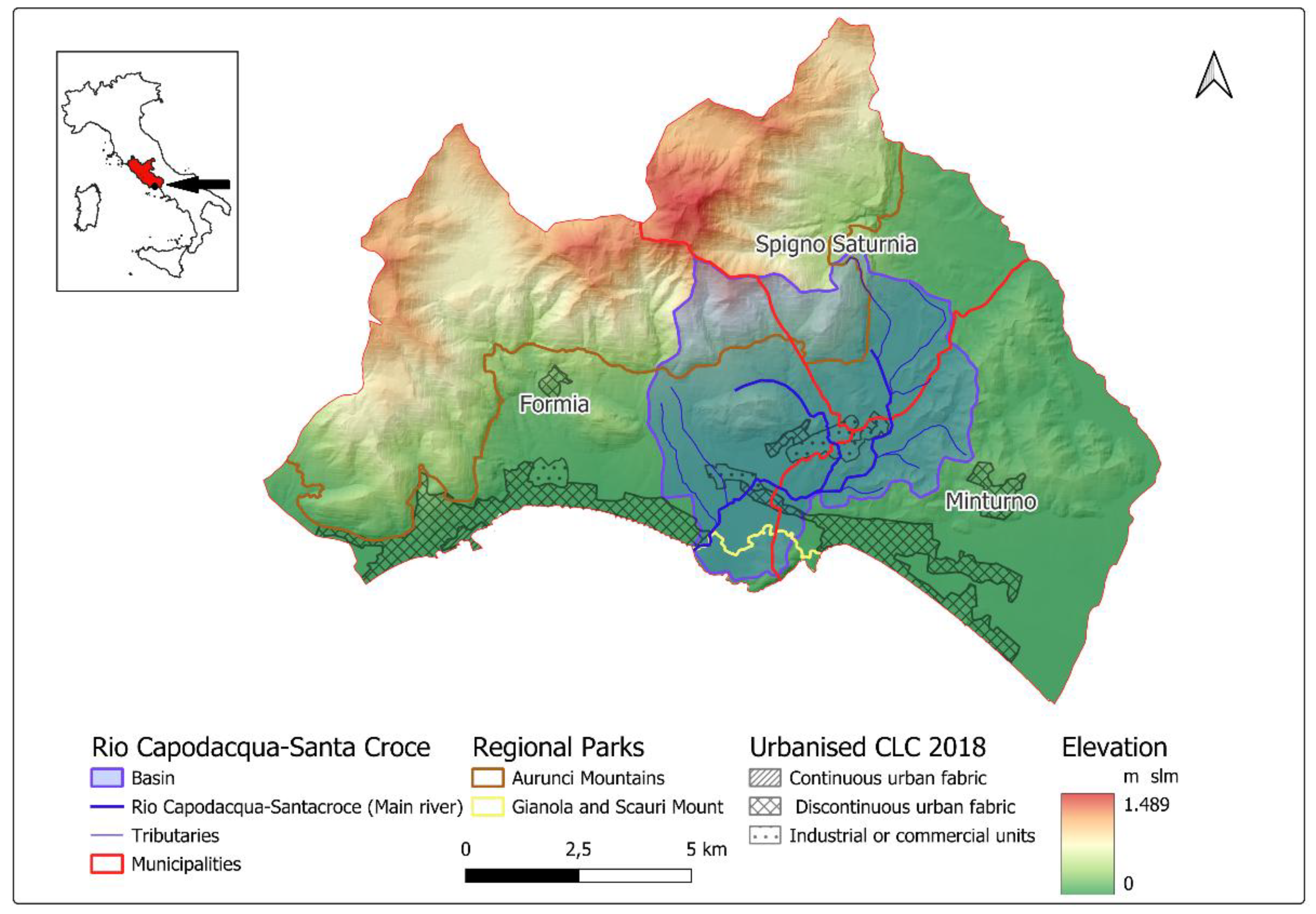
Figure 2.
- The development of the River Contract adopted on the Rio Capodacqua Santa Croce in its phases, documents and contents. The figure does not show what follows the approval of the Action Programme and therefore its execution and verification of effectiveness through an open and inclusive participatory process.
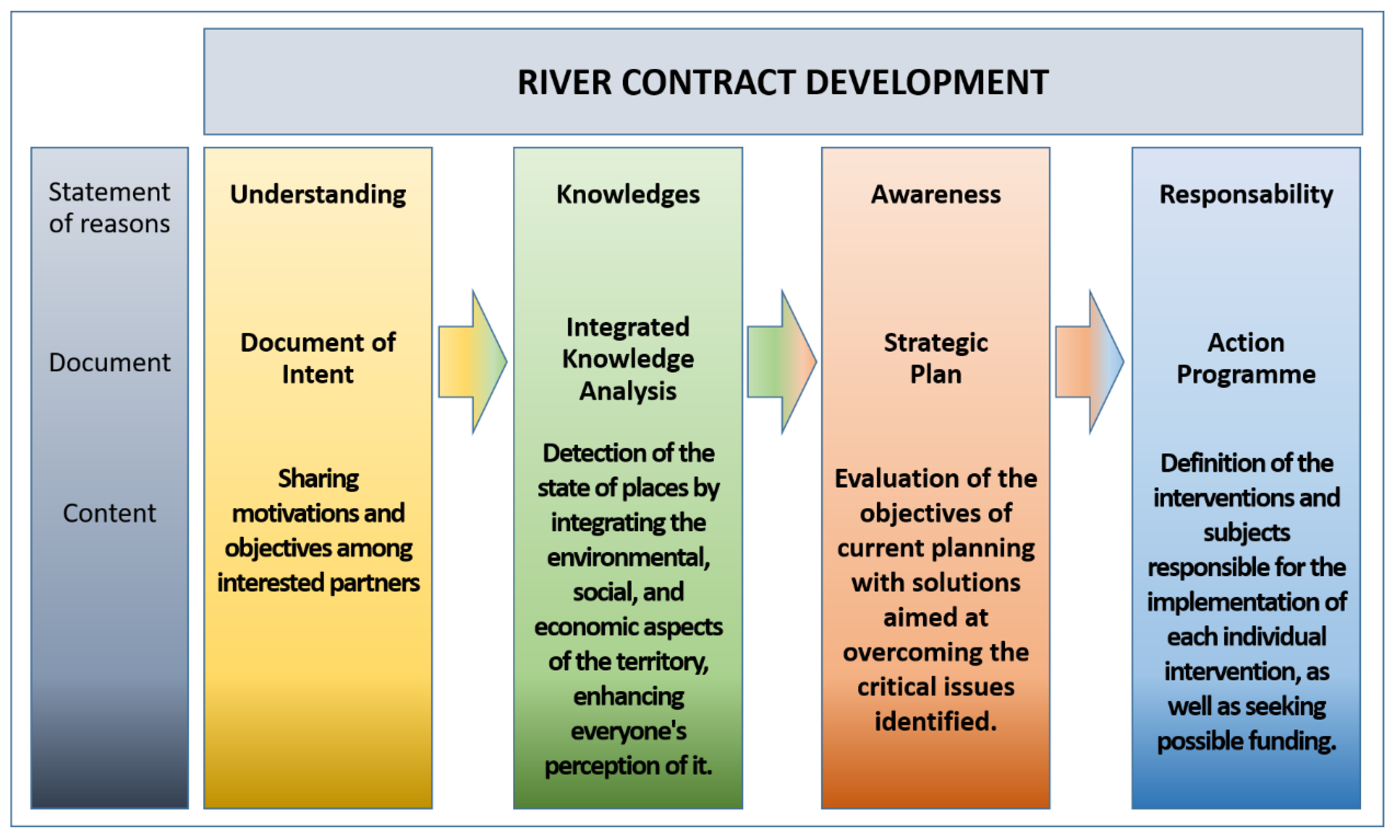
Figure 3.
– Interferences in the upper, middle, and lower reaches of the Rio Capodacqua-Santa Croce. The upper reaches (a) highlight the spread of areas covered by natural vegetation and cultivated fields. The middle reaches (b) contain an industrial site and areas with discontinuous urbanization. Finally, the lower reaches (c) exhibit numerous connections to the road and rail network and denser urbanization.
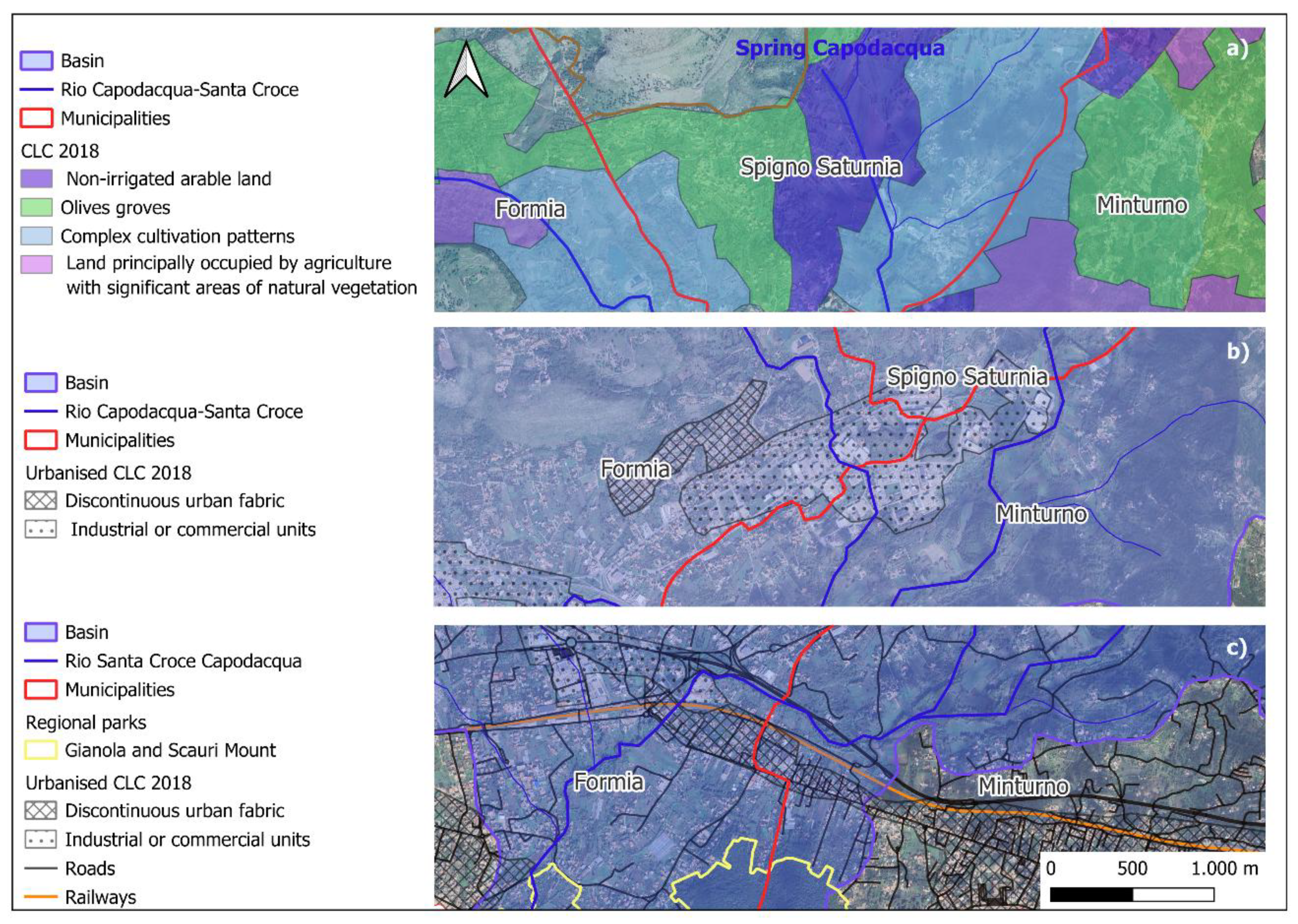
Figure 4.
Rio Capodacqua-Santa Croce: a) the photo shows it in a condition of minimum flow to the point of threatening the Minimum Vital Flow; b) this photo highlights a state of the riparian vegetation that needs to be restored to its natural characteristics.
Figure 4.
Rio Capodacqua-Santa Croce: a) the photo shows it in a condition of minimum flow to the point of threatening the Minimum Vital Flow; b) this photo highlights a state of the riparian vegetation that needs to be restored to its natural characteristics.
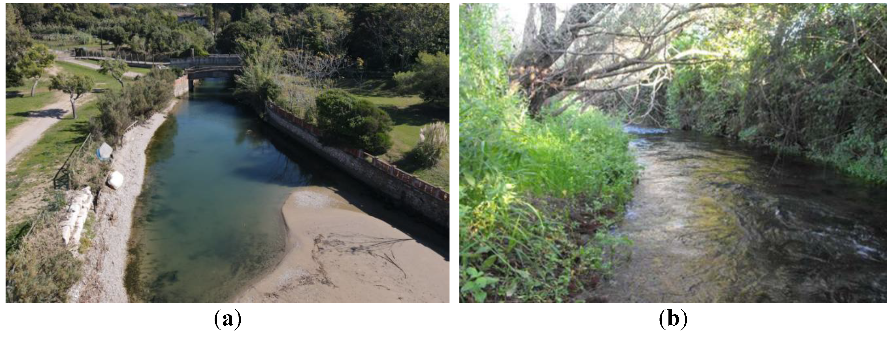
Figure 5.
These photos show the spring (a) and mouth (b) of the Rio Capodacqua-Santa Croce respectively.
Figure 5.
These photos show the spring (a) and mouth (b) of the Rio Capodacqua-Santa Croce respectively.
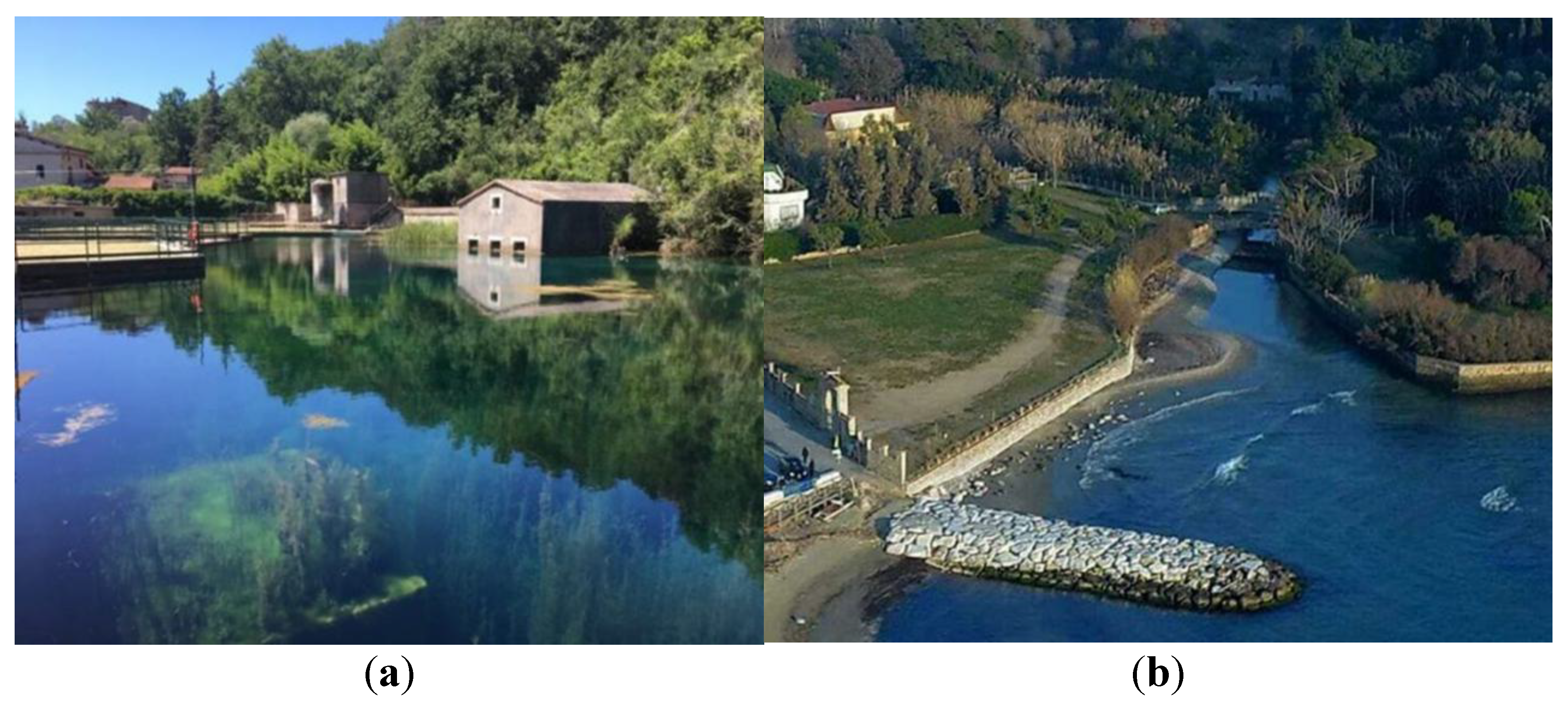
Figure 6.
- The map uses a map of municipal roads to highlight the flood risk of the Rio Capodacqua-Santa Croce with return periods of 30, 200, and 500 years. It should be noted that the areas with the highest intensity correspond to interference with the road and rail network.
Figure 6.
- The map uses a map of municipal roads to highlight the flood risk of the Rio Capodacqua-Santa Croce with return periods of 30, 200, and 500 years. It should be noted that the areas with the highest intensity correspond to interference with the road and rail network.
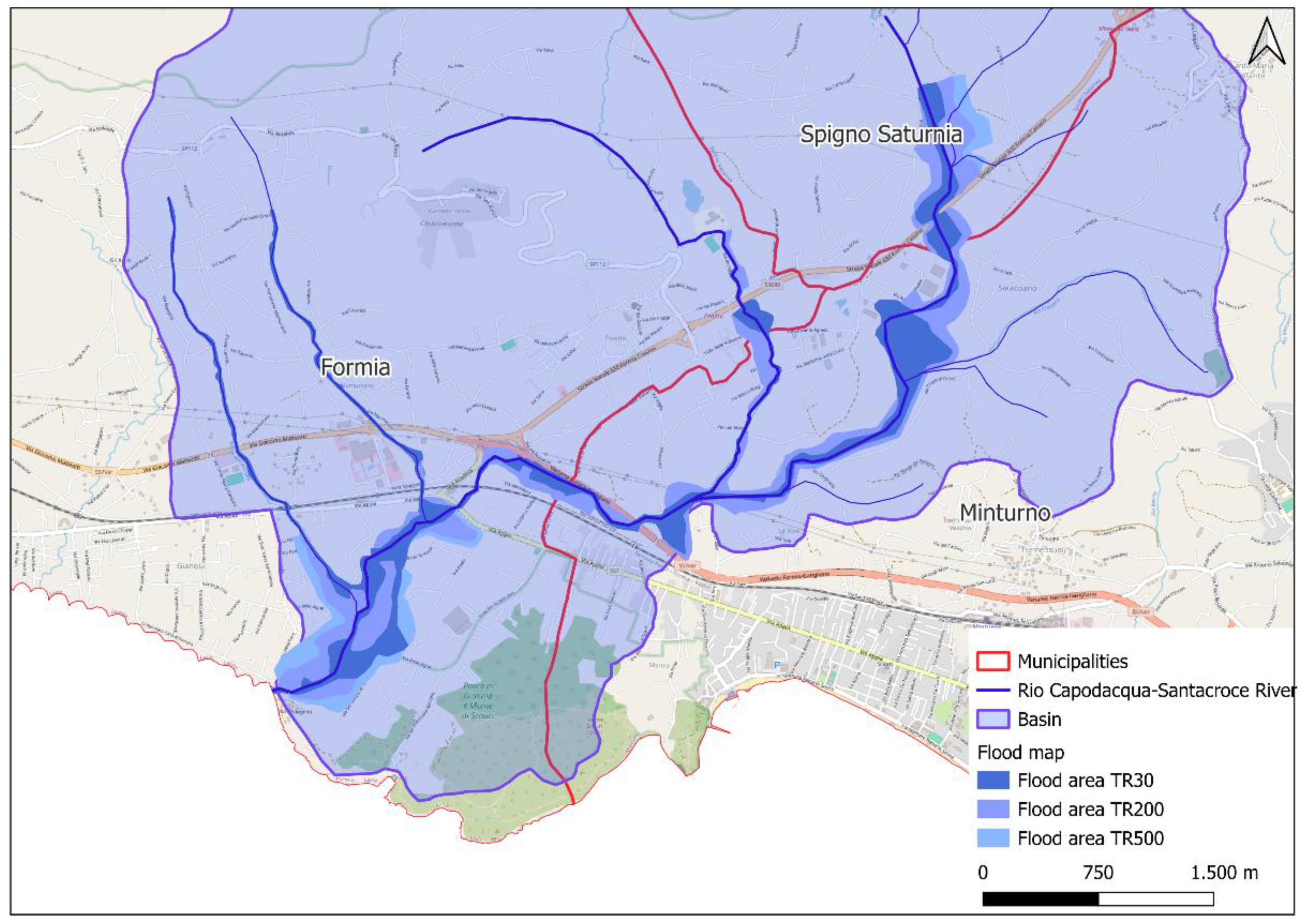
Figure 7.
- Evaluation of some of the actions planned by the River Contract with respect to sustainability goals. Key: 3) Good health and well-being; 4) Quality education; 6) Clean water and sanitation; 7) Affordable and clean energy; 11) Sustainable cities and communities; 12) Responsible consumption and production; 13) Climate action; 15) Life on land (SDG 15); 17) Partnerships for the goals.
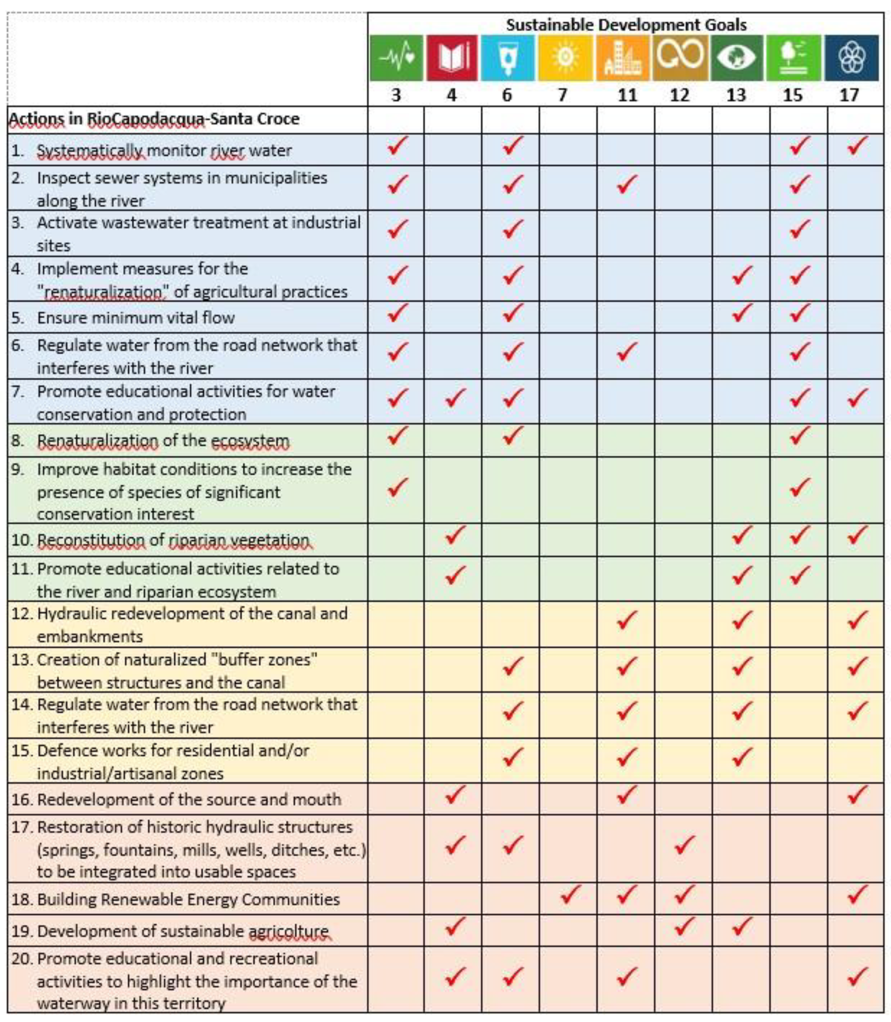

Table 1.
- Summary assessment for habitat types present in the SCI IT6040024 "Rio Capodacqua-Santa Croce” and assessment for them (based on recent survey [44]).
Table 1.
- Summary assessment for habitat types present in the SCI IT6040024 "Rio Capodacqua-Santa Croce” and assessment for them (based on recent survey [44]).
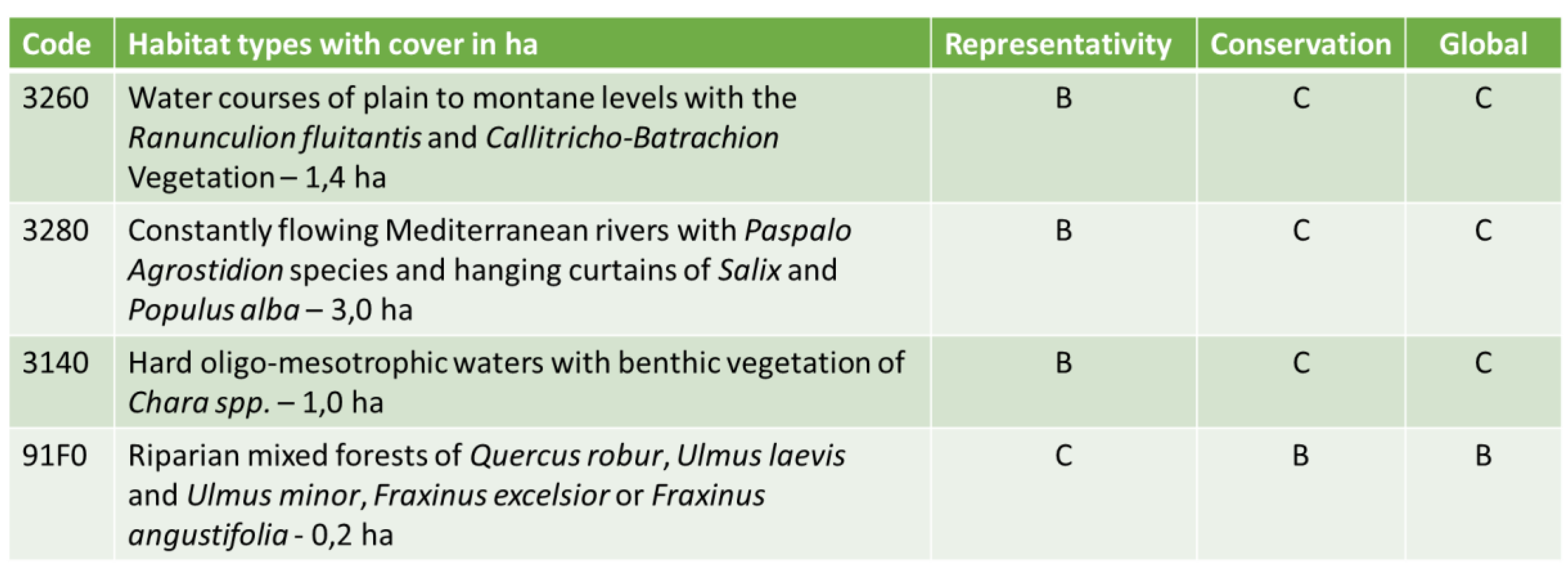 |
KEY: Representativity: A=excellent, B=good, C=significant, D=not significant. Conservation status: A=excellent, B=good, C=average or poor. Global assessment: A=excellent, B=good, C=average.
Table 2.
Summary assessment for species present in the SCI IT6040024 "Rio Capodacqua-Santa Croce” referred to in Article 4 of Directive 2009/147/EC and listed in Annex II of Directive 92/43/EEC and site evaluation for them (based on recent survey [44]).
Table 2.
Summary assessment for species present in the SCI IT6040024 "Rio Capodacqua-Santa Croce” referred to in Article 4 of Directive 2009/147/EC and listed in Annex II of Directive 92/43/EEC and site evaluation for them (based on recent survey [44]).
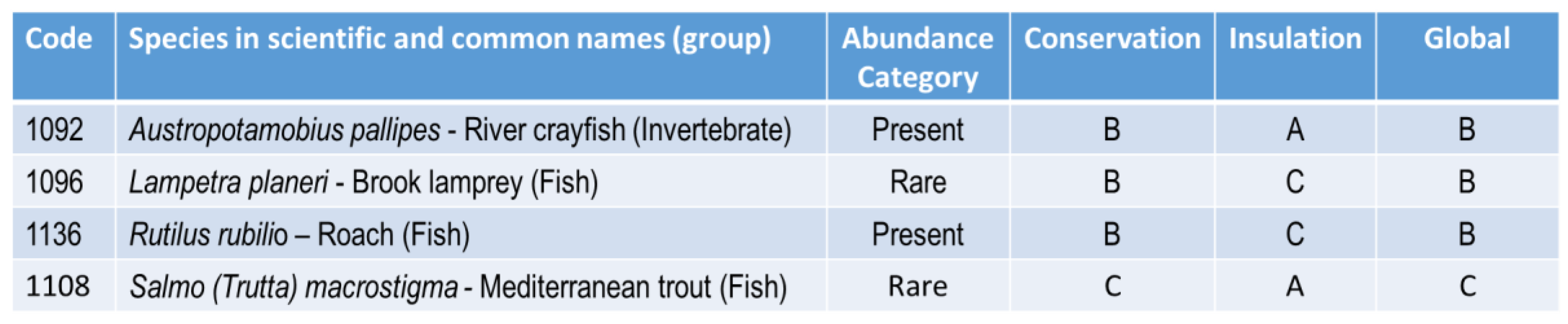 |
KEY: Conservation: A=excellent, B=good, C=average or reduced. Insulation: A: population (largely) isolated; B: population not isolated, but at the margins of its range; C: population not isolated within a broad distribution range. Global assessment: A=excellent, B=good, C=average.
Disclaimer/Publisher’s Note: The statements, opinions and data contained in all publications are solely those of the individual author(s) and contributor(s) and not of MDPI and/or the editor(s). MDPI and/or the editor(s) disclaim responsibility for any injury to people or property resulting from any ideas, methods, instructions or products referred to in the content. |
© 2025 by the authors. Licensee MDPI, Basel, Switzerland. This article is an open access article distributed under the terms and conditions of the Creative Commons Attribution (CC BY) license (http://creativecommons.org/licenses/by/4.0/).
Copyright: This open access article is published under a Creative Commons CC BY 4.0 license, which permit the free download, distribution, and reuse, provided that the author and preprint are cited in any reuse.


