
Submitted:
28 October 2025
Posted:
30 October 2025
You are already at the latest version
Abstract
Background: Amid rapid urbanization, rural regions are undergoing profound spatial restructuring and landscape degradation. This study establishes a remote sensing–empowered integrated framework of Diagnosis–Elements–Structure–Function (DESF) to systematically investigate the mechanisms and pathways of rural spatial reconstruction and landscape reshaping. The DESF framework provides a comprehensive approach to understanding how ecological, cultural, and structural dimensions interact in reshaping rural territories. Methods: By integrating multi-source remote sensing imagery, GIS spatial analysis, and extensive field surveys, the study develops a multi-indicator rurality diagnostic model, a dual-dimensional “ecological–cultural” landscape classification system, and a spatial structure optimization module. Together, these form a four-tiered technical route encompassing data acquisition, diagnosis, reconstruction, and application. The methodological design bridges quantitative analysis and human-centered interpretation, enabling an in-depth understanding of rural transformation dynamics. Results: Empirical analysis in Quzhou County from 1985 to 2015 reveals a 40% decline in the Rurality Index, displaying a distinct “strong-south, weak-north” spatial differentiation pattern under accelerated urbanization. Landscape classification identified 108 distinct landscape elements, grouped into three major landscape assemblages—natural-ecological, agricultural-productive, and rural-living. Spatial structural analysis uncovered six dominant settlement morphologies, including fan-shaped expansion and clustered growth, reflecting a coupled nature–society dual-driven mechanism. Based on these insights, a “core preservation–peripheral integration” spatial strategy is proposed, establishing a hierarchical “central–ordinary–specialized village” system and a functional zoning model characterized by “one core, multiple nodes.”Conclusions: The study advances theoretical understanding by refining the conceptual system of “diagnosis–reconstruction” in rural spatial studies, innovates methodologically by integrating remote sensing–based quantitative diagnostics with qualitative cultural perception, and contributes practically by offering an operational spatial governance toolkit for rural revitalization. The DESF framework demonstrates strong applicability, scalability, and international reference value for sustainable rural development and policy-making under global urbanization dynamics.
Keywords:
DESF framework
; remote sensing–empowered analysis
; rurality
; spatial reconstruction
; landscape transformation
1. Introduction
Over the past four decades, China’s rapid urbanization has profoundly reshaped the socio-spatial fabric of its rural territories [1-3]. By 2024, the country’s permanent urban population had reached 940 million, with the urbanization rate rising to approximately 67% [4]. While this transformation has accelerated modernization and enhanced economic efficiency, it has simultaneously generated a series of structural challenges in rural areas—including population outmigration, farmland abandonment, and increasing landscape fragmentation [5-7].Against this backdrop, a pressing question arises: how can scientific diagnosis and systematic reconstruction be leveraged to optimize rural spatial organization and enhance landscape functionality within the context of national territorial governance [8-14]? To address this challenge, the present study establishes a Remote Sensing–Empowered Diagnosis–Elements–Structure–Function (DESF) Framework, designed to explore effective pathways toward sustainable rural transformation.
To systematically address these challenges, this study focuses on the spatial reconstruction and landscape reshaping of rural settlements within the framework of China’s Rural Revitalization Strategy, with the overarching goal of building an ecological–economic–cultural synergistic rural system. The theoretical foundation integrates systems theory, reconstruction theory, and demand theory: systems theory underpins the identification of key elements and the analysis of structural relationships; spatial reconstruction theory provides quantitative approaches for morphological optimization; and demand theory links functional enhancement with human-centered values.This interdisciplinary framework strengthens the application of remote sensing technologies in element extraction and structural diagnosis, thereby bridging the persistent gap between physical spatial patterns and socio-ecological processes that has limited traditional research.
A comprehensive review of existing literature reveals substantial progress in the evaluation of rurality, landscape classification systems, and landscape functionality analyses. Nevertheless, three critical limitations persist [15-22]. First, current studies lack a multi-scalar analytical framework that deeply integrates remote sensing technologies. Second, the “diagnosis–intervention” mechanism remains underdeveloped, hindering the translation of analytical insights into actionable spatial strategies. Third, ecological functions and cultural values remain fragmented within prevailing landscape classification schemes. Collectively, these gaps constrain the scientific robustness and operational feasibility of rural spatial restructuring and landscape revitalization strategies. To address these challenges, this study develops a Remote Sensing–enabled Diagnosis–Element–Structure–Function (DESF) analytical framework that systematically integrates multi-source Remote Sensing (RS), Geographic Information Systems (GIS), and field-based investigations. The DESF framework operates through a four-tier technical pathway encompassing the data, diagnostic, reconstruction, and application layers. Using Quzhou County, Hebei Province, as a representative case, the study employs spatiotemporal remote sensing interpretation to characterize the dynamics of rural transformation. The framework advances three methodological innovations: (1)a multi-indicator rurality diagnostic model; (2)a dual-dimensional landscape classification system that unifies ecological and cultural dimensions; (3)a spatial-syntax–guided structural optimization module. Collectively, these developments yield a replicable and scalable technical protocol for evidence-based rural spatial reconstruction and landscape regeneration.
The academic innovations of this study are threefold. First, it establishes the DESF spatial reconstruction model, which bridges theoretical inquiry and planning practice through a logical sequence of problem diagnosis–element identification–structural optimization–functional enhancement. This model operationalizes the conceptual framework into a practical pathway for spatial transformation. Second, the study develops a remote sensing–based dual-dimensional landscape classification method that integrates ecological indicators—such as the Normalized Difference Vegetation Index (NDVI)—with cultural perception mapping, thereby unifying ecological functionality and cultural semantics within a single analytical system. Third, it designs a Remote Sensing–Geographic Information System (RS–GIS) integrated spatial decision-support tool, validated through an empirical study in Quzhou County. This tool provides a spatially explicit protocol for landscape regeneration and governance in analogous agricultural regions.
In summary, this study advances a comprehensive integration of remote sensing technology with the DESF model, thereby refining the theoretical cognition of rural spatial systems through a diagnosis–reconstruction paradigm. Methodologically, it innovates a quantitative–perceptual synthesis that bridges spatial analytics with human-centered insights. Practically, it delivers an operational spatial governance tool aligned with China’s Rural Revitalization Strategy. The empirical validation in Quzhou County demonstrates that this research paradigm effectively supports the optimization of rural spatial structures and the regeneration of landscape functions, offering a Chinese case exemplar that enriches the global discourse on sustainable rural transformation.
2. Materials and Methods
2.1. Study Area and Regional Context
Quzhou County is located in the northeastern part of Handan City, Hebei Province, China, spanning geographic coordinates 114°50′30″–115°13′30″E and 36°34′45″–36°57′57″N (Figure 1). It borders Qiuxian and Guantao Counties to the east, Jize and Yongnian Counties to the west, Feixiang and Guangping Counties to the south, and Pingxiang and Guangzong Counties to the north. The county extends approximately 45 km north–south and 23 km east–west, covering a total area of 667.52 km², of which arable land accounts for roughly 73%. Administratively, it comprises five towns and five townships, encompassing 342 villages, and forms part of the core agricultural region of the North China Plain.Geographically, Quzhou County lies on the eastern foothills of the Taihang Mountains within the Hai River Basin, characterized by generally flat terrain with a gentle slope trending southwest to northeast. The predominant landform is an alluvial plain formed by historical deposits from the Zhang, Sha, Ming, and Yellow Rivers, encompassing gentle ridges (11.5%), secondary slopes (7.6%), and interfluvial lowlands (35%). These geomorphological features exert significant control over regional water–heat distribution, groundwater depth, and soil salinization processes.
The county’s soil parent material consists predominantly of riverine alluvium, exhibiting a horizontal gradient from sandy to loamy to clayey textures. The northwest region is dominated by clay deposits from the Zhang River, whereas the southeast is characterized by sandy loam derived from the Yellow River; the Fuyang River Basin primarily features light or medium loam soils. Overall, loamy fluvo-aquic soils predominate, with relatively high fertility, providing favorable conditions for the cultivation of crops such as wheat and maize.The climate is classified as a warm temperate, semi-humid continental monsoon climate, with pronounced seasonal variation. The mean annual temperature is 13.2 °C, and the frost-free period lasts approximately 203 days. Annual precipitation averages 534.9 mm, with roughly 70% concentrated between July and September. The mean annual potential evapotranspiration is approximately twice the precipitation, resulting in frequent spring droughts and hot, rainy summers. Climatic variability is significant, with extreme weather events occurring regularly.Major rivers include the Fuyang River, Zhizhang River, and the Lao Sha River. The total water resource storage is estimated at 99.368 million cubic meters. However, surface water suffers from severe pollution, and groundwater exhibits salinization, collectively contributing to water scarcity that constrains agricultural development.
The region’s natural vegetation is highly simplified, with no extensive native forests; the landscape is dominated by artificial shelterbelts and farmland tree networks, resulting in low ecosystem stability and a strong dependence on human management. Arable land accounts for over 73% of the total area. The dominant cropping system follows a double-cropping regime of winter wheat and summer maize, with principal crops including wheat, maize, and cotton. Between 1985 and 2015, grain production increased substantially, cotton remained the primary cash crop, vegetable cultivation expanded markedly, and livestock production developed steadily. Overall, the agricultural structure shifted toward income-enhancing production, establishing the county as a high-yield, stable agricultural region.In 2015, the total population was 505,964, with 92.6% engaged in agriculture and an urbanization rate of 38.5%. Over the three decades from 1985 to 2015, the population increased by 192,809, accompanied by a significant rise in urbanization. Concurrently, the industrial structure transitioned from agriculture-dominated to industry-dominated, and regional GDP increased from 134 million CNY to 10.985 billion CNY, reflecting pronounced economic transformation.
Overall, Quzhou County, located in the North China Plain, represents a typical intensive agricultural and major grain-producing region, combining both regional representativeness and high research value. The landscape is dominated by agricultural land, exhibiting the characteristic features of plain-region farming systems, making it an ideal case for investigating the mechanisms of rural spatial restructuring and landscape evolution. Quzhou County serves not only as a key provider of regional ecosystem services but also as a sensitive area to ecological changes under rapid urbanization and industrial transformation. Since the implementation of the “Integrated Management of Drought, Flood, Salinity, and Alkalinity” program in 1973, the county has successfully transitioned from “saline-alkaline wastelands” to high-yield, stable farmland, markedly improving agricultural production conditions. However, the intensification of agricultural inputs and land use has also led to overextraction of groundwater, soil degradation, and water pollution, revealing the inherent tensions between agricultural modernization and ecological carrying capacity and reflecting the common challenges faced in rural spatial restructuring across the North China Plain.In this context, selecting Quzhou County as a study area allows for a systematic exploration of rural spatial pattern evolution, landscape functional restructuring mechanisms, and optimization pathways. The findings are not only highly representative but also broadly transferable, providing a scientific basis for sustainable rural restructuring and integrated territorial spatial governance in northern China and comparable agricultural regions globally.
2.2. Data Source
To ensure the comprehensiveness of the spatiotemporal analysis, this study integrates multi-source datasets, including remote sensing imagery, statistical data, field surveys, and cartographic records (Table 1). Remote sensing data were obtained from the Computer Network Information Center of the Chinese Academy of Sciences (http://www.gscloud.cn/) and were used to classify land-use types in Quzhou County into eight categories based on regional characteristics: arable land, orchards, forestland, grassland, built-up land, transportation land, water bodies, and unused land.Socioeconomic data were drawn from multiple authoritative sources, including Quzhou County land-use datasets (1985–2015), the county soil survey report, the Quzhou County Statistical Yearbooks (1985–2015), the Quzhou County Hydrology and Environmental Bulletins (1985–2015), the county agricultural economic statistics ledger (1985–2015), as well as national publications such as the China Statistical Yearbook (1985–2015), the China Economic Statistical Yearbook (1985–2015), and the China Agricultural Statistical Yearbook (1985–2015). These datasets provide critical support for the construction of the rurality index and the socioeconomic interpretation of spatial reconstruction results.
2.3. Data Preprocessing and Integration
2.3.1. Remote Sensing Image Processing
All remote sensing datasets were preprocessed using ENVI 5.6 and ArcGIS, following a standard workflow: (1) Radiometric and atmospheric correction – Landsat and Sentinel imagery were corrected using the FLAASH module and DOS1 method, respectively. (2) Image mosaicking and clipping – imagery was clipped according to the administrative boundaries of Quzhou County, with a 1:10,000 topographic map serving as the spatial reference. (3) Geometric correction – implemented using a 30 m digital elevation model (DEM) and UAV-derived ground control points, achieving a root mean square error (RMSE) < 0.3 pixels. (4) Supervised classification – a Random Forest (RF) classifier was applied to generate eight land-use categories: arable land, orchards, forestland, grassland, built-up land, transportation land, water bodies, and unused land.⑤Accuracy assessment – conducted using 500 randomly distributed validation points to calculate overall accuracy and the Kappa coefficient.The processed datasets were stored in the WGS 84/UTM Zone 50N projection to ensure compatibility with socioeconomic and vector datasets, facilitating integrated spatial analysis.
2.3.2. Establishing a Rural Sexuality Assessment System
To evaluate rurality, this study selected 10 core indicators across four dimensions to construct a comprehensive rurality assessment dataset [23-27]. All indicators were normalized using the range-standardization method, and a weighted composite index was generated through the Analytic Hierarchy Process (AHP). The resulting Rurality Index (RI) ranges from 0 to 1, where lower values indicate a higher degree of urbanization, and higher values reflect stronger rural characteristics.
2.3.3. Data Quality and Uncertainty Control
To ensure the robustness and scientific rigor of the analysis, several quality control and uncertainty mitigation measures were implemented during data processing and integration. First, remote sensing images from similar vegetation phenology periods were selected to guarantee temporal comparability across different years. Spatial accuracy and geographic alignment were ensured using ground control points (GCPs) and a digital elevation model (DEM). Land-use classification accuracy was validated through comparison with field sampling points and high-resolution imagery. Socioeconomic data from multiple sources were cross-checked to ensure numerical consistency and reliability. Additionally, sensitivity analyses were performed on the weighting parameters used in the construction of the Rurality Index (RI) to assess the stability and robustness of the model outputs.By systematically integrating these multi-source datasets, this approach provides a solid empirical foundation for the quantitative (RS-GIS) and qualitative (field-based socio-surveys) analysis of rural spatial reconstruction and landscape reshaping.
2.4. Research Framework and Methods
2.4.1. Overall Research Framework
This study employs Quzhou County, Hebei Province, as a case study, integrating multi-source remote sensing data (Landsat series and Sentinel-2), geographic information systems (GIS), and a hybrid subjective–objective landscape classification approach to construct a remote sensing–supported “Diagnosis–Element–Structure–Function” (DESF) framework for rural spatial reconstruction and landscape reshaping. The analytical logic follows a four-stage progressive framework:
(1) Remote Sensing Diagnosis: Using multi-temporal datasets from 1985–2015 combined with field surveys, NDVI, NDBI, and Rurality Index (RI) modeling were employed to identify spatial differentiation patterns exhibiting a “strong south–weak north” gradient.
(2) Element Analysis: A total of 108 landscape elements encompassing production, livelihood, and ecological functions were extracted. These were organized into a dual-dimensional “ecology–culture” classification framework, resulting in 8 site-condition types and 55 landscape units.
(3) Structural Modeling: Coupling remote sensing interpretation with spatial orientation analysis enabled the identification of rural settlement morphologies, revealing the natural–social driving mechanisms underpinning spatial organization.
(4) Functional Optimization: Based on assessments across production, settlements, ecology, and infrastructure, a “core retention–peripheral integration” strategy was proposed, forming a three-tier settlement hierarchy and a “single-core, multiple-node” functional zoning system.
This framework embeds remote sensing technology throughout the full analytical workflow, from rurality diagnosis and landscape unit identification to spatial form quantification, establishing a cross-disciplinary methodological system that provides a practical, operational pathway for optimizing rural spatial systems.
2.4.2. Establishing a Rural Sexuality Evaluation System
The concept of rurality is intended to quantify the extent to which a region retains rural characteristics across demographic, economic, spatial, and cultural dimensions . Building upon prior studies and refining the framework for Quzhou County, this study defines rurality as a multi-dimensional attribute reflecting population, land, industry, and ecological conditions. The model integrates 10 core indicators into four overarching dimensions—demographic, economic, spatial, and functional—capturing the influences of natural dynamics, spatial dynamics, population dynamics, and economic dynamics (Table 2).
All indicators were normalized using the range-standardization method (Equation 1), constraining values to the [0,1] interval. To reflect differences in indicator significance, weights (Wj) were assigned using the Analytic Hierarchy Process (AHP) in conjunction with expert judgment (Equation 2). The resulting Rurality Index (RI) is expressed as:
In the equation, Sij represents the normalized value of indicator j for township i; Xij denotes the observed value of indicator j for township i; Xmax and Xmin and correspond to the maximum and minimum values of indicator j across all townships in Quzhou County, respectively.
Higher Rurality Index (RI) values indicate stronger rural characteristics. Using the village as the basic spatial unit, the study employed ArcGIS for spatial visualization, applying inverse distance weighting (IDW) interpolation to generate a continuous map of rurality distribution. This approach reveals the spatial heterogeneity of rural characteristics across the region.
2.4.3. Landscape Classification and Functional Evaluation
Following established principles of rural landscape classification [28-30], this study adopts a dominant functional–morphology classification approach. Objective physical indicators, including topography, soil conditions, and land use, were combined with a bottom-up evolutionary perspective and subjective landscape perception to categorize rural landscapes into four hierarchical levels: elements, types, zones, and clusters (Figure 2). The specific workflow is as follows:
(1) Field survey for subjective landscape perception: Visual observations of terrain, land cover, and structural patterns were recorded in situ. Imagery elements were extracted and validated with references to classical pastoral poetry, providing a culturally anchored perspective. Given the dynamic nature and vast number of subjective elements, the study focused on those derived from canonical pastoral literary sources.
(2) Objective physical landscape classification and mapping: Heterogeneous factors such as soil type and micro-topography were analyzed using high-resolution remote sensing imagery, enabling the extraction of objective data on terrain, land cover, and soil conditions.
(3) Integration and validation of subjective and objective classifications: Using ArcGIS, layers of elevation, slope, and soil were overlaid to delineate site-condition units, which were then combined with land cover data to define landscape type units. Guided by the principle of dominant function, kernel density analysis was applied to aggregate landscape type units into four primary functional landscape zones: production, settlement, ecological, and infrastructure.
2.4.4. Analysis of Rural Spatial Form
To rigorously analyze the spatial structure and functional evolution of rural settlements, this study addresses pressing phenomena in Quzhou County, including village consolidation, settlement expansion, and functional differentiation. Within the “Diagnosis–Elements–Structure–Function” (DESF) analytical framework, we integrated remote sensing techniques with spatial orientation modeling to establish a progressive research pathway: problem identification→element analysis→structural modeling→functional optimization [31-35]. This approach aims to achieve moderate restructuring of rural spatial organization and synergistic enhancement of landscape functions through quantitative methods, thereby providing a robust spatial governance basis for the implementation of rural revitalization strategies. Grounded in systems theory, and at the county scale, we employed 1:10,000 topographic maps and high-resolution remote sensing imagery to construct the spatial sequence of rural settlements using an axial line model. This enabled the decomposition of rural spatial structures into constituent elements, including landscape units, settlement morphologies, and network systems, and facilitated the quantitative assessment of spatial accessibility and structural characteristics for different settlement types, such as fan-shaped expansions and clustered formations.
3. Results
3.1. Rural Diagnosis and Analysis
3.1.1. Time-Series Analysis of Rural Sexuality Index
Based on the constructed Rurality evaluation framework, which integrates key indicators such as population density, industrial structure, and infrastructure, this study quantitatively calculated the Rurality Index (RI) for ten townships in Quzhou County for the years 1985, 1997, 2003, 2012, and 2015, and systematically analyzed its temporal evolution and spatial differentiation.Overall, between 1985 and 2015, the mean RI declined from 0.4832 to 0.2897, representing a 40% reduction, indicative of an accelerated rural-to-urban transition and significant increase in urbanization. The coefficient of variation exhibited a declining trend from 1985 to 2003, followed by an upsurge through 2015, producing a pronounced “U-shaped” fluctuation pattern. This trajectory suggests that relative differences in rurality initially converged and subsequently diverged, while the overall regional development remained orderly, reflecting the gradual emergence of coordinated regional growth.

Table 3.
Analysis of Rural Sexuality Index Calculation Results for Quzhou County.
| Region | 1985 | 1997 | 2003 | 2012 | 2015 |
|---|---|---|---|---|---|
| Mean | 0.4832 | 0.4363 | 0.4106 | 0.3955 | 0.2897 |
| Minimum Value | 0.3082 | 0.2353 | 0.2818 | 0.2635 | 0.1248 |
| Maximum Value | 0.7370 | 0.7550 | 0.7170 | 0.7288 | 0.5149 |
| Range | 0.4288 | 0.5197 | 0.4352 | 0.4653 | 0.3901 |
| Standard Deviation | 0.1162 | 0.1445 | 0.1148 | 0.1259 | 0.1118 |
| Coefficient of Variation | 0.2405 | 0.3312 | 0.2796 | 0.3183 | 0.3859 |
Spatial Pattern Evolution Analysis (Figure 3): The study area exhibits a pronounced north–south gradient in rurality, characterized by high rurality in the south and lower values toward the north, indicating that northern regions are more strongly influenced by urbanization. Quzhou Town, located at the county center, consistently maintains low rurality due to intensive economic activity and high population density, whereas southern townships such as Nanliyue Township sustain high rurality levels, primarily reflecting their continued reliance on traditional agricultural production systems.Using the natural breaks method, rurality was classified into four levels: strong, relatively strong, weak, and relatively weak. Between 1985 and 2015, the proportion of weak and relatively weak rurality areas increased markedly from 25% to 60%, whereas strong rurality areas declined sharply from 40% to 10%. Based on these temporal-spatial dynamics, rurality evolution can be categorized into four types:Rapid decline type (e.g., Baizhai and Dahedao Townships): Located adjacent to urban built-up areas, these regions experience strong urban spillover effects, with annual rurality index declines exceeding 5%.Gradual decline type (e.g., Nanliyue Township, Anzhai Town): Dominated by agriculture, these areas show a more moderate development trajectory, with annual rurality index declines below 2%.Fluctuating decline type (e.g., Quzhou Town, Houcun Town): Development is nonlinear and occasionally exhibits temporary increases, potentially reflecting regional policy adjustments.Increasing type: No significant upward trends were observed during the study period; no clear cases were identified.These patterns reveal the heterogeneous impacts of urbanization on rural landscapes and underscore the spatially differentiated nature of rural transformation in Quzhou County.
3.1.2. Spatial Differentiation Analysis of Rural Sexuality Index
Spatial Clustering Analysis Based on Global Moran’s I (Table 4): The analysis indicates that the spatial distribution of rurality in Quzhou County largely follows a random pattern, with no statistically significant global clustering detected. This suggests that, at the county scale, rural characteristics lack pronounced spatial aggregation.Local spatial autocorrelation analysis, however, identifies two distinctive regional patterns: hotspots (e.g., Nanliyue Township and Anzhai Town) exhibit high-value clustering of rurality, reflecting concentrated rural attributes, whereas coldspots (e.g., Quzhou Town and Huaichiao Township) display low-value clustering, signaling the deepening influence of urbanization and modernization processes.Notably, these spatial patterns demonstrate dynamic temporal shifts: hotspot regions are gradually migrating toward the county periphery, while coldspot regions are expanding inward toward the central areas. These trends reflect uneven regional development and the limited radiative capacity of the county’s urban core, potentially driven by imbalances in urban–rural resource allocation or region-specific policy orientations.In summary, Quzhou County exhibits an overall weakening of rurality, with spatial distribution evolving from highly uneven toward relative equilibrium. Nonetheless, local heterogeneity persists, and some areas continue to experience a decline in rural characteristics. These findings underscore the need, within the context of urban–rural integration, to prioritize the restructuring of rural spatial frameworks and the restoration of regional rural identities, thereby enhancing endogenous rural vitality and advancing sustainable development objectives.
While Moran’s I can reveal the overall spatial distribution of rurality across townships, its local instability necessitates a more refined assessment of spatial autocorrelation. To address this, the present study employs the Getis-Ord Gi* statistic within the spatial analysis module of ArcGIS 10.2 to identify local hotspots and coldspots of rurality in Quzhou County. By calculating the Getis-Ord Gi* values for each study unit across five time points from 1985 to 2015 and classifying the results using the Jenks natural breaks method, we generated a local spatial association map of rurality, capturing the fine-scale spatial heterogeneity of the county (Figure 4).
As illustrated in Figure 6, the spatial clustering of rurality hotspots is pronounced across all periods, predominantly concentrated in the southwestern townships of Quzhou County, including Nanliyue Township, Baizhai Township, and Anzhai Town. These areas consistently exhibit elevated rurality indices, largely attributable to natural geographic constraints, peripheral location relative to the central urban area, lagging socioeconomic development, and traditional agricultural practices, resulting in persistently high and spatially stable rurality.In 1985, the most strongly clustered hotspots were located in central Nanliyue Township, Anzhai Town, Houcun Town, and Baizhai Township. By 1997, the spatial pattern of hotspots remained largely unchanged, with the exception of Houcun Town, which downgraded to a secondary hotspot, and Yizhuang Township emerging as a new hotspot; this configuration remained stable through 2003. In 2012, the hotspot areas shifted to Nanliyue Township, Houcun Town, Anzhai Town, and Yizhuang Township, with Baizhai Township reclassified as a secondary hotspot. By 2015, the intensity of hotspots diminished, persisting only in Nanliyue Township and Anzhai Town, reflecting that over the past three decades, qualitative transformations in socioeconomic and agricultural factors have substantially reshaped the original spatial clustering of rurality in Quzhou County.
Secondary hotspot areas are characterized by relatively high rurality within the unit itself, surrounded by lower rurality in neighboring areas, indicating a localized spatial association. In 1985, these secondary hotspots were concentrated in the northeastern townships of Siqian, Henanqian, and Huaijiao. By 1997, spatial clustering weakened due to fluctuations in the rural economy, rendering the aggregation pattern less pronounced. Between 2003 and 2012, clustering effects re-emerged and stabilized, predominantly in southern and southwestern areas, including Dahedao Township, Baizhai Township, Houcun Town, and Anzhai Town. By 2015, the extent of secondary hotspots had contracted to Anzhai Town and Houcun Town.This temporal evolution reflects the tangible effects of recent Chinese rural development policies, demonstrating that urban–rural integration has laid a foundation for the implementation of the Rural Revitalization Strategy and provided critical support for the optimization of rural production, residential, and ecological spaces.
Secondary cold spots are characterized by relatively low rurality within the unit itself, surrounded by higher rurality in neighboring areas. In Quzhou County, the spatial extent of secondary cold spots remained limited, with relatively minor fluctuations over time. In 1985, no significant clustering was observed. By 1997, Siqian Township, Henanqian Township, and Huaijiao Township emerged as distinct secondary cold spots, reflecting the radiative influence of regional rural balanced development since the 1990s. In 2003, the secondary cold spots shifted to the central townships of Quzhou and Huaijiao. Between 2012 and 2015, clustering intensity reached its peak, primarily concentrated in the northern and central townships of Henanqian, Siqian, Baizhai, Huaijiao, and Quzhou.
Cold spots represent areas where both the focal unit and its surrounding regions exhibit low rurality. From 1985 to 2012, cold spot clustering in Quzhou County remained statistically insignificant. By 2015, however, a weak clustering pattern emerged in the central townships of Quzhou and Huaijiao, indicating localized areas of advanced urbanization and diminished rural characteristics.
3.2. Classification and Functional Evaluation of Rural Landscapes
Integrating Subjective Perception with Objective Data for Rural Landscape Assessment,this study conducted a systematic classification and evaluation of the rural landscapes in Siqian Township and Huaijiao Township, Quzhou County, employing a methodology that combines subjective perception with objective data analysis. The approach integrates iconographic elements derived from classical pastoral poetry with contemporary geospatial analysis techniques, thereby establishing a comprehensive rural landscape classification framework. The methodology and resulting classifications are detailed as follows:
3.2.1. Results and Analysis of Subjective Landscape Classification
Based on a subjective landscape classification approach, 35 representative pastoral poems were selected and analyzed to extract landscape elements, yielding a total of 235 subjectively perceived iconographic features. Recognizing that visual landscape information at the micro-scale village level plays a pivotal role in regional landscape function planning and design, this study undertook repeated field surveys to observe and document the landscape types of each village unit within the study area. These observations were systematically cross-validated against the iconographic landscape elements derived from the pastoral poetry, ensuring precise identification of visually perceived features. Through this integrative process, approximately 108 distinct rural landscape element types were finalized for the study area (Table 5).
3.2.2. Objective Landscape Classification Results and Analysis
Based on the slope classification standards established within the objective landscape classification framework (Figure 2), the digital elevation model (DEM) of the study area was analyzed using ArcGIS 3D tools to extract slope characteristics. The analysis revealed a homogeneous slope profile, comprising only flatlands and gentle slopes, both exerting minimal influence on the overall landscape pattern. Given the study area’s generally low-lying topography and high landscape visibility, flatlands were designated as the primary terrain type, while gentle slopes were considered negligible. At a finer scale, the study area’s micro-topography was categorized into four types: secondary slopes, depressions, gentle ridges, and alluvial fans at breach points. Spatial analysis indicated that these micro-topographic types were evenly distributed in north–south bands, with terrain gently sloping from southwest to northeast and exhibiting an interlaced arrangement of ridges, slopes, and depressions, producing an undulating surface morphology. Such micro-topographic heterogeneity within village units creates highly differentiated landform conditions, which in turn exert a significant influence on rural landscape patterns.
The study area encompasses six soil types, which, after consolidation, revealed that loam and clay dominate the soils of Si-tuan Town and Hua-qiao Township. Loamy soils, characterized by loose texture, high water and nutrient retention, and strong tillage suitability, primarily support rural production landscape zones, including vegetable and cereal crop cultivation. Through spatial overlay analysis of topography, micro-topography, and soil properties, eight classes of rural landscape site conditions were delineated for the study area (Figure 5a). Subsequently, considering the area-weighted influence of different site conditions on landscape types in rural planning practice, a laboratory-based integrative analysis was conducted, supplemented by field surveys and expert judgment, to exclude classification categories with influence weights below 1%. Finally, by overlaying the site condition map with land cover data using ArcGIS 10.2 spatial analysis tools, 55 distinct rural landscape types were identified across the study area (Figure 5b).
Based on the classified rural landscape types, this study employed kernel density analysis combined with spatial overlay techniques to extract distinct landscape type layers and convert them into point features for density computation. Through subsequent overlay analysis, four functional rural landscape zones were delineated (Table 6): rural settlement landscape zones, rural infrastructure landscape zones, rural ecological landscape zones, and rural production landscape zones.
The analysis indicates that the rural landscapes of Sizhuang Town and Huaijiao Township are predominantly oriented toward production functions, primarily providing agricultural products to meet residents’ daily needs. However, the settlement landscape within the study area exhibits a highly fragmented spatial pattern, with most villages characterized by underdeveloped infrastructure and pronounced landscape homogeneity. Coupled with severe population aging, these factors have accentuated the trend of rural hollowing, highlighting an urgent need for settlement protection and spatial integration strategies to mitigate landscape fragmentation. Within the ecological landscape zones, the largest land cover proportion is occupied by highly sensitive areas such as saline-alkali soils and sandy lands, followed by forest patches, water bodies, and sparse woodland-grasslands that provide ecological regulation functions. Field surveys reveal that ecological forest patches are generally small and scattered, primarily located around homesteads and along river corridors, and are frequently encroached upon by construction land. These findings underscore the fragility of the region’s ecological base, suggesting that the implementation of rural revitalization strategies must balance economic development with stringent protection and optimized spatial configuration of ecological land.
3.2.3. Integrative Analysis of Subjective and Objective Landscape Types
Based on the above analysis, and considering the hierarchical relationships among landscape elements, landscape classes, and landscape zones, as well as the integrated methodology combining objective and subjective rural landscape classifications, the rural landscapes within the study area were ultimately consolidated into three primary landscape clusters (Table 7):
(1) Natural and semi-natural ecological landscapes: This cluster primarily encompasses the ecological landscape zones within villages, as well as the transitional areas linking ecological and production landscapes.
(2) Agricultural production-dominated landscapes: This cluster is principally composed of farmland, orchards, livestock areas, and agricultural facilities within the production landscape zones, as well as related infrastructure in rural facilities zones. It also includes certain rural life landscape elements associated with agricultural activities.
(3) Rural life and cultural landscapes: Defined by varying densities of rural settlements and cultural tourism sites reflecting local rural characteristics, this cluster is primarily represented by settlement landscape zones, portions of rural facilities zones, and landscape elements associated with livestock, labor, and daily village life.
This hierarchical and integrative classification framework provides a systematic basis for understanding the functional, ecological, and socio-cultural dimensions of rural landscapes, offering a robust foundation for spatial planning and landscape management in the context of rural revitalization.
3.3. Analysis of the Spatial Structure and Functions of Rural Settlements
This study systematically compiled spatial data and ancillary information for all townships in Quzhou County and employed ArcGIS to construct a rural spatial axial model of the study area. Subsequent spatial analyses enabled the characterization of key rural spatial elements and facilitated the identification of the fundamental structural patterns of Quzhou County’s rural landscape.
3.3.1. Time-Series Analysis of Rural Sexuality Index
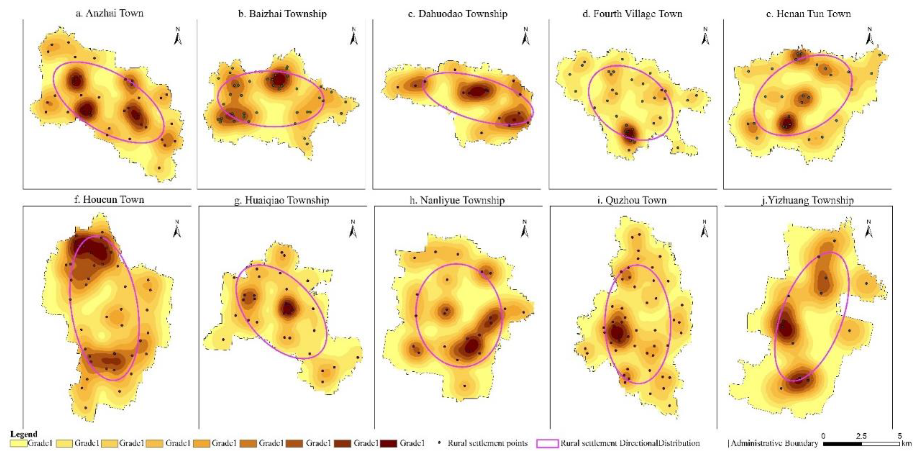
Through the analysis of landscape structural spatial patterns, six principal rural spatial morphology types were identified in Quzhou County (Figure 6):
Fan-shaped expansion: Settlements constrained by natural conditions extend in a single, fixed direction, forming a fan-like pattern. For example, Dadao Township expands outward from the township government core toward surrounding production landscape areas.
Multidirectional expansion: Settlements circumvent natural obstacles and extend from initial clusters in multiple directions, generating a multidirectional configuration, as observed in Henan Tuan and Anzhai Townships.
Linear/striped: Settlements elongate along rivers, main roads, or other linear features, creating narrow, banded distributions, exemplified by Yizhuang Township along river courses.
Dispersed: Settlements are scattered in a point-like arrangement due to natural geographic constraints, such as in Baizhai Township, where villages are distributed sparsely across gentle slopes to preserve arable land.
Clustered/aggregated: Multiple relatively independent settlement clusters are connected via transportation networks, forming composite units; differences in industrial development act as the primary driver, as seen in Sihtuan and Huaqiao Townships.
Concentric/ring-shaped: Settlements radiate outward from a dominant core, forming concentric circular patterns, as exemplified by Quzhou Town expanding around the Zhizhang River and its central development hub.
Figure 6.
Analysis of Spatial Structural Characteristics of Settlements in Townships of Quzhou County.
Figure 6.
Analysis of Spatial Structural Characteristics of Settlements in Townships of Quzhou County.
3.3.2. Time-Series Analysis of Rural Sexuality Index
Based on the analysis of Quzhou County’s spatial structure, research on rural spatial reconfiguration should not be confined solely to the layout and patterning of individual settlements. From a broader perspective, rural spaces at different hierarchical levels exhibit pronounced differentiation in their settlement landscapes, reflecting variations in population scale and the functional roles associated with local industrial development. Therefore, elucidating the intrinsic drivers of rural spatial structural evolution necessitates analysis from the perspective of the integrated development of the entire village–town system.
Examination of rural settlements in Quzhou County indicates that the current village–town system exhibits a hierarchical structure encompassing three principal levels: urban towns, established towns and township market towns, and grassroots villages with central villages. The spatial evolution of settlements at the grassroots and central village levels has historically constituted the primary mode of rural spatial structural transformation. Although rapid urban–rural economic integration in China has induced certain changes in village organization, the internal industrial composition and patterns of population mobility have largely remained stable, with regional cooperative linkages even showing signs of weakening relative to previous decades. Consequently, contemporary rural spatial development essentially manifests a dualistic differentiation between township and urban spaces.
A comparison of Quzhou County’s villages over the past four decades reveals that, overall, rural spaces have undergone varying degrees of expansion from their original settlement foundations (Figure 7). Nevertheless, China’s policies for small-town development, rural territorial development, and modern agricultural advancement uniformly advocate for sustainable pathways. This indicates a tension between the large-scale expansion of townships in Quzhou County and the overarching development strategy, which can be attributed to the following factors:
First, the spatial development of townships in Quzhou County reveals a pronounced imbalance between rural and urban growth. This disequilibrium not only impedes the urbanization process of villages but also disrupts the demographic structure between urban and rural areas, thereby constraining the deepening development of rural spaces. Such an imbalanced pattern runs counter to the strategic objectives and core principles underpinning China’s small-town development policies.
Second, the hierarchical structure of rural development has diverged from its intended evolutionary trajectory. Within Quzhou County’s urban–rural development process, the central villages have largely failed to assume their intended core functions within the township hierarchy. Consequently, their role in supporting urban–rural linkages is insufficient, and the intrinsic logic of urbanization is inadequately reflected. In the current phase of urban–rural transformation, the evolution of rural spatial structures should be guided by the development trajectory of rural industries. For instance, promoting the transition from traditional smallholder farming to modernized rural agriculture can stimulate secondary and tertiary industrial growth, thereby enabling more comprehensive and integrated regional transformations within constrained spatial limits.
Third, isolated development and lack of integration exacerbate spatial inefficiencies. Recent investigations of Quzhou County’s townships, grassroots villages, and central villages indicate a pervasive pattern of spatial isolation, particularly between townships and the county seat in terms of economic connectivity. Within townships, inter-village linkages remain weak, and economic structures are fragmented, limiting the establishment of effective coordination and mutual-support mechanisms. This development model complicates township-level integrated planning, hindering the realization of optimal rural spatial development, and in some cases, driving deviation in the growth trajectory of grassroots villages and environmental degradation.For example, in Huaqiao Township, certain natural villages have undertaken unplanned small-town tourism projects. Local tourism infrastructure is underdeveloped, project planning is simplistic, and in many cases, models are directly transplanted from other regions without adaptation to local conditions. Such practices have prompted neighboring townships to imitate these initiatives without adequately assessing their own industrial capacities. This uncoordinated replication, often at the expense of agricultural land, has led to the proliferation of tourism-related construction, resulting in structural imbalances within local economies and consequent ecological degradation.
3.3.3. External Drivers of the Evolution of Rural Spatial Structure and Function
The fundamental building blocks of rural space are the “household” units, with the “homestead” representing the most basic constituent element of each unit. From a biological perspective, cellular dynamics unfold through four stages: division, variation, migration, and reorganization. Analogously, within rural space, a dynamic evolutionary relationship exists between household units and their constituent homestead elements. In the context of contemporary urbanization, the continuous adjustment and interaction of elements within each unit collectively drive the emergence of novel spatial structures and functional configurations in rural landscapes.
Studies indicate that the evolution of rural household structures in Quzhou County exhibits distinctive patterns. Influenced by traditional familial values, farm households often maintain the integrity of the overall household unit even when homesteads are subdivided among adult descendants, without undergoing substantive separation. This pattern facilitates the continuous spatial expansion of co-residential, multi-generational family living spaces. However, analysis of analogous family evolutions in Quzhou reveals that this pattern and household fragmentation are not strictly dichotomous; rather, they exist in a symbiotic relationship (Figure 8a).With socio-economic transformation and the liberalization of social attitudes, Quzhou has experienced urban-like phenomena: most adult descendants increasingly prefer independent living, giving rise to transitional household structures (Figure 8b). Within the context of the Rural Revitalization Strategy, small independent family units have emerged as the dominant form. Enhanced self-awareness, growing privacy demands, and evolving lifestyle habits collectively drive the proliferation of courtyard-style independent residences. These socio-cultural shifts directly reshape rural household structures and, by extension, trigger cascading effects in the overall spatial configuration—accelerated household fragmentation directly promotes the scaling and concentrated subdivision of homesteads.
Concurrently, the organization of rural service facilities, commercial layouts, and cultural spaces has evolved in response to changes in household–homestead relationships. Specifically, existing village cultural and recreational facilities increasingly fail to meet the needs of current population structures and household scales, leading to the contraction of public activity spaces and functional obsolescence of traditional villages. Addressing these challenges systematically is imperative in the ongoing reconstruction of rural spatial and landscape structures.
3.4. Optimization Strategy for Rural Spatial and Landscape Based on “Diagnosis-Elements-Structure-Function”
Building upon the diagnostic assessment of rurality and the theoretical analysis of spatial structure, functional attributes, and landscape typologies across Quzhou County, this study selects two representative villages—Huaiqiao Township and Situa Town—as empirical case studies for detailed spatial analysis and reconstruction.
3.4.1. Diagnosis: Existing Issues in Rural Spatial Planning
The spatial configuration of Huaijiao Township and Disitun Town in Quzhou County is jointly constrained by the distribution of farmland and the orientation of the local river network, resulting in pronounced disparities in the scale of village settlements. Some villages are sparsely populated and widely dispersed, while others have expanded in size due to the concentration of resources and population. At present, the planning of central villages is largely characterized by a “planned-from-above” approach, predominantly shaped by external forces rather than by the intrinsic logic of local spatial evolution or the distinctive regional context. This externally imposed planning has led to imbalances in spatial structure and fragmentation of functional zones—for instance, the physical separation of residential areas from farmlands and the irrational allocation of public service facilities. Such disjunctions not only reduce the efficiency of villagers’ daily lives but also undermine social cohesion within rural communities.
3.4.2. Core Elements: Identification of Key Components in Rural Spaces
A comprehensive factor evaluation identifies four key determinants driving rural spatial restructuring: population size, land-use intensity, industrial foundation, and landscape value. Population size dictates the vitality and sustainability of village life; land-use intensity reflects the efficiency of spatial and resource utilization; industrial foundations underpin long-term economic resilience; and landscape value integrates ecological conservation with cultural continuity. Through field investigations and systematic literature review, this study identifies representative village units with significant preservation potential (Table 8). The selection criteria encompass indicators such as the integrity of historic architecture, the degree of community participation, and environmental adaptability—ensuring a balanced consideration of social, ecological, and cultural dimensions in rural spatial renewal.
3.4.3. Structure: Optimization of Rural Settlement Spatial Structure
Building upon an in-depth evaluation of land resources, population distribution, and environmental carrying capacity, this study proposes a structural optimization strategy characterized by a “core preservation–peripheral integration” model to enhance the overall spatial efficiency of rural settlements. In practical implementation, a benchmark of 120 m² per capita is established as the standard for land-use intensity. Villages with per capita land-use areas below this threshold and limited future development potential are designated for priority preservation, ensuring the continuous improvement of their infrastructure and service systems. Conversely, small and spatially dispersed settlements are subject to consolidation and integration, achieved through relocation or concentrated resettlement within adjacent areas to minimize resource redundancy. Ultimately, this approach shapes a three-tier spatial structure system comprising central villages, general villages, and specialized villages (Table 9). Central villages function as regional cores, hosting public services and administrative governance; general villages maintain essential residential and agricultural functions; and specialized villages focus on cultural heritage preservation or the development of distinctive local industries. This hierarchical configuration not only optimizes land-use efficiency but also reinforces the spatial logic of sustainable rural transformation.
In the process of rural structural optimization, priority is given to preserving larger settlement units—particularly villages with an area exceeding 500 m². These settlements typically possess abundant productive resources such as farmland, forests, and water systems, alongside a robust economic carrying capacity that sustains both employment and living needs for a larger population. Consequently, they serve as the core nodes within the rural spatial system.By implementing an integrated spatial strategy that harmonizes production, living, and ecological protection zones, and coupling it with landscape renewal measures—including environmental enhancement and ecological restoration—the regional influence and functional connectivity of these key settlements can be substantially strengthened. This approach not only amplifies their capacity to drive economic growth and social cohesion in surrounding areas but also establishes a more resilient and synergistic rural spatial framework (Table 10).
3.4.4. Function: Strategies for Enhancing the Functional Role of Rural Spaces
Guided by the principle of “production–living–ecological” functional synergy, a central-village suitability evaluation system is established to optimize the functional layout of rural space. Using the farming radius as the core indicator, the framework integrates the operational requirements of modern agricultural production. By analyzing the effects of various modes of transportation—such as walking, cycling, and motorized vehicles—on agricultural efficiency, the study determines a set of rational threshold ranges for effective farming radii (Table 11). This quantitative approach provides a scientific basis for aligning spatial organization with contemporary rural production systems, thereby enhancing both functional integration and spatial resilience within the rural landscape.
Based on the analysis of transportation modes and farming efficiency, the service radius of central villages is defined as 1.5 km, corresponding to an approximate 10-minute travel time. This establishes a 3.0 km spatial service depth, providing a quantitative foundation for functional zoning and spatial planning. A three-dimensional functional evaluation framework—integrating production, ecology, and living dimensions—is constructed (Table 12). The production dimension includes six indicators such as irrigation well density and road network accessibility; the ecological dimension encompasses river network density and forest coverage ratio; and the living dimension considers population size, economic level, and five related factors. Together, these indicators form a scientifically grounded model for assessing the functional suitability of central villages, enabling data-driven optimization of rural spatial structure and sustainable regional development.
Grounded in growth pole theory and the farming-radius threshold, the study defines a current central-village population scale of approximately 5,000 residents, with a projected capacity of 5,000–6,000 residents and a planned land allocation of 50 hectares per unit. Through a comprehensive suitability evaluation, six central villages—such as Xiaodiba and Nanlongtang—were identified, forming a “one core, multiple nodes” functional network system.Integrating landscape value assessment and development potential, Huaijiao Township and Disitun Town were divided into four construction zoning categories (Table 13):
(1) Priority Development Zone:serving as the regional service core, represented by Huaijiao and Disitun Villages. Leveraging their administrative advantages, these zones focus on strengthening infrastructure capacity and economic diffusion effects. Land-use intensification strategies are employed to promote coordinated development with surrounding settlements.
(2) Key Development Zone:exemplified by Wangzhuang Village, this zone emphasizes eco–industrial integration, with diversified industries such as agricultural cultivation and rural tourism as its foundation. It encourages county–university collaboration to foster “production–landscape” integrated functional units.
(3) Guided Development Zone:targeting Deng Village and other agriculture-dominated settlements, this zone prioritizes technical guidance to optimize land-use structures, enhance agricultural productivity, and improve living services, thereby advancing the transition from traditional to modern agriculture.
(4) Restricted Development Zone:focusing on Yanglizhuang Village and other ecologically sensitive areas, this zone strictly protects forestlands, grasslands, and related ecological resources while allowing limited eco-tourism development, thus establishing a robust rural ecological security buffer.
This classification system operationalizes the spatial hierarchy of rural revitalization, balancing economic growth, ecological preservation, and social equity within a scientifically grounded and regionally adaptive planning framework.
4. Discussion
4.1. Analysis of the Relevance and Innovative Aspects of the Findings in Relation to Existing Research
This study, grounded in a self-constructed “Diagnosis–Element–Structure–Function” analytical framework, systematically explores the pathways of rural spatial restructuring and landscape reshaping supported by remote sensing technology. It aims to bridge the persistent divide in conventional research between physical spatial patterns and socio-ecological processes. The results reveal that between 1985 and 2015, the rurality index of Quzhou County exhibited an overall declining trend, with a spatial differentiation pattern characterized by a “strong south–weak north” gradient. Based on a dual-dimensional “ecological–cultural” landscape classification system, three dominant landscape groups were identified, informing the proposal of a “core preservation–peripheral integration” spatial optimization strategy.
Compared with previous studies, the observed attenuation of rurality aligns with the general trajectory of declining rural attributes across China’s major agricultural plains, reinforcing the notion of continuous rural decharacterization under urbanization pressures. However, unlike conventional approaches that focus on single-dimensional indicators—such as economic or demographic metrics—this study integrates remote sensing data with socioeconomic variables, constructing a four-dimensional composite evaluation system encompassing population density, economic vitality, spatial morphology, and functional characteristics. This multidimensional model markedly enhances both the systematic rigor and spatial resolution of rurality diagnosis. In terms of landscape classification and functional assessment, the proposed “ecological–cultural” dual-axis framework transcends traditional paradigms that emphasize either production or ecology alone. While existing literature widely recognizes the importance of landscape multifunctionality, most fail to effectively integrate objective biophysical indicators with subjective cultural perception, resulting in a conceptual disjunction between ecological functionality and cultural value. In contrast, this study achieves synergistic identification of ecological and cultural dimensions by coupling objective remote sensing metrics—such as NDVI and land-use data—with subjective cultural imagery derived from classical pastoral poetry. This integrated approach overcomes the long-standing separation between physical space and human perception, ensuring both analytical coherence and interpretive depth. Beyond its methodological innovation, the study also advances empirical precision by achieving fine-scale landscape identification at the village level for the first time. A total of 108 landscape elements, 55 landscape units, and three major landscape groups were systematically delineated. Compared with prior research conducted at township or county scales, this fine-grained classification represents a substantial enhancement in spatial granularity and taxonomic resolution. Overall, this work contributes a novel theoretical and methodological framework that integrates remote sensing diagnostics, functional evaluation, and cultural interpretation, providing both a scientific foundation and technical roadmap for the coordinated optimization of rural landscapes in socio-ecological transformation contexts.
4.2. Research Limitations and Future Prospects
Although this study develops a “Diagnosis–Element–Structure–Function” (DESF) framework that systematically integrates remote sensing technologies with multi-source data to provide an operationalized quantitative pathway for rural spatial restructuring and landscape pattern reshaping, several limitations remain, warranting attention in future research.
First, constraints in remote sensing data resolution and temporal coverage. This study primarily relies on Landsat series (30 m resolution) and Sentinel-2 imagery (10–20 m resolution). While these datasets effectively support land-use/land-cover mapping and landscape classification at macro scales, their ability to resolve fine-scale features—such as intra-village settlement structures or small ecological patches—remains limited. For instance, detailed characteristics of rural homesteads or the distribution of agricultural ditches are difficult to capture, which constrains the fineness of the ecological–cultural dual-axis landscape classification. To mitigate this limitation, the study incorporated GF-1 high-resolution imagery and field surveys for cross-validation, and applied random forest classification combined with Kappa consistency checks to enhance reliability. Future studies could further improve precision by integrating higher-resolution or hyperspectral data to capture microscale landscape heterogeneity.
Second, potential bias arising from subjective weighting in the rurality evaluation system. Indicator weights in this study were determined using the Analytic Hierarchy Process (AHP), complemented by expert consultation and sensitivity analyses to improve model robustness. Nevertheless, subjective judgment cannot be entirely eliminated, particularly in quantifying cultural functions within the functional dimension, which relies on questionnaire responses and imagery-based cultural feature extraction. Variations in respondent perception may affect the reliability and validity of these measurements, potentially introducing bias into the rurality index and, consequently, influencing the spatial optimization strategies. To reduce this risk, the study integrated multi-source data, including statistical yearbooks, remote sensing derivations, and field records, and verified spatial pattern stability through local spatial autocorrelation analyses. Future work could explore automatic weight optimization algorithms in machine learning to enhance both objectivity and adaptive capacity of the indicator system.
Finally, the representativeness of the case study and the caution required for generalization. Quzhou County, as a representative agricultural core of the North China Plain, exhibits mechanisms of rural spatial evolution with some degree of generality. However, due to the significant heterogeneity of China’s landscapes—including mountainous, hilly, and coastal regions—rural systems elsewhere may differ fundamentally in structure, function, and evolutionary pathways. Direct transplantation of the DESF framework and technical protocols to other regions may face adaptation challenges arising from differences in natural conditions, social institutions, or cultural traditions. While the methodology emphasizes transferability and replicability, practical application requires local parameterization and model calibration to account for regional characteristics.
This careful reflection underscores that, although the DESF framework provides a robust methodological foundation, its precision, objectivity, and generalizability must be continually refined through higher-resolution data, adaptive evaluation techniques, and context-sensitive application.
In summary, future research can advance and deepen the study of rural spatial restructuring along three complementary directions, facilitating a transition from “description and explanation” to “simulation and regulation”, and providing more scientifically grounded and operational spatial governance tools for the precise implementation of rural revitalization strategies:
First, enhance multi-source remote sensing integration and micro-scale analytical capability. To overcome the limitations of medium- and low-resolution imagery in capturing intra-village structures and small ecological patches, future studies should incorporate UAV (drone) imagery, hyperspectral data, and nighttime light observations, establishing a “satellite–airborne–ground” integrated monitoring system. For example, UAV-acquired centimeter-level resolution imagery can enable precise identification of homestead layouts, agricultural ditches, and other micro-scale features. Coupled with object-based classification techniques, this approach can refine the ecological–cultural dual-axis landscape classification. Moreover, the integration of time-series InSAR analysis is recommended to dynamically monitor settlement changes, thereby improving the capacity to capture temporal patterns in rural spatial evolution.
Second, optimize the objectivity and adaptive capacity of the rurality evaluation system. To address uncertainty arising from subjective weighting, future work could adopt objective weighting methods such as entropy weighting or principal component analysis, or employ machine learning algorithms (e.g., random forests, XGBoost) for feature importance assessment, reducing human-induced bias. In quantifying cultural functions, multi-source human perception data, including social media posts and travel narratives, can be integrated. Natural language processing techniques, such as semantic network analysis, can extract region-specific cultural features, thereby enhancing the representativeness and spatiotemporal coverage of the indicator system.
Third, strengthen the regional adaptability and transferability of the DESF framework. Although the Quzhou County case provides a representative example, its applicability to heterogeneous landscapes requires further validation. Comparative studies across diverse geographic units—such as mountainous, hilly, and coastal regions—are recommended to establish a regional parameter database and classification calibration models, enabling the modular and localized deployment of the DESF framework. For instance, terrain position indices may be incorporated to adjust landscape classification in hilly areas, whereas enhanced ecological vulnerability indicators are needed in coastal zones. Additionally, integrating the DESF framework with national territorial spatial planning systems can form a “diagnosis–intervention–evaluation” closed-loop, thereby enhancing its responsiveness to policy and planning objectives.
Collectively, these directions offer a roadmap for advancing rural spatial research, integrating high-resolution observational data, objective evaluation metrics, and regionally adaptive frameworks to support sustainable, multifunctional, and culturally attuned rural landscapes.
5. Conclusions
This study takes Quzhou County in Hebei Province as an empirical case and addresses the core scientific questions of rural spatial restructuring and landscape pattern optimization under the framework of China’s Rural Revitalization Strategy. A comprehensive research framework was developed and implemented, structured around the “Diagnosis–Element–Structure–Function” (DESF) logic. By integrating multi-source remote sensing data, geographic information system (GIS) analysis, spatial syntax modeling, and field-based social surveys, the study systematically elucidates the evolutionary patterns of rurality, mechanisms of landscape functional differentiation, and spatial structural characteristics of settlements in Quzhou County. Based on these analyses, operationally feasible spatial optimization pathways were proposed. The main research findings are summarized as follows:
5.1. Key Research Findings
5.1.1. The Evolution Of Rurality Exhibits Pronounced Spatiotemporal Differentiation and Structured Characteristics
Between 1985 and 2015, the mean rurality index in Quzhou County declined from 0.4832 to 0.2897, representing a 40% reduction and reflecting the profound impacts of rapid urbanization and rural transformation. The coefficient of variation displayed a “U-shaped” fluctuation, indicating that disparities in rurality initially narrowed before expanding, while regional coordination gradually improved amidst these oscillations. Spatially, the distribution of rurality exhibited a distinct “strong south–weak north” gradient, with regions of high rurality gradually contracting and the proportion of low-rurality areas increasing from 25% to 60%. Moran’s I analysis revealed that global spatial clustering of rurality was not significant, yet persistent local hotspots (e.g., Nanliyue Township, Anzhai Town) and coldspots (e.g., Quzhou Town, Huaijiao Township) remained, highlighting uneven resource allocation and heterogeneous development dynamics between urban and rural areas. Based on the rate and pattern of rurality change, villages were classified into rapid-decline, slow-decline, and fluctuating-decline types, revealing the divergent regional responses to urbanization pressures and indicating that local socio-economic and spatial contexts mediate how settlements adapt to transformative forces.
5.1.2. Developing an Integrated Objective–Subjective Framework for Rural Landscape Classification and Functional Assessment
Drawing on imagery derived from pastoral poetry and field surveys, the study identified 108 representative landscape elements encompassing living, production, ecological, and infrastructural categories, thereby establishing a landscape element database that links cultural perception with spatial entities. The study area is predominantly plain terrain (99.98%), with microtopography characterized by an alternating pattern of ridges, slopes, and depressions, and soils primarily classified as loamy gley and clayey gley. Through GIS overlay analysis, eight landscape site-condition units and 55 landscape unit types were delineated. The region was subsequently partitioned into production landscapes (83.58%), settlement landscapes (11.42%), ecological landscapes (3.82%), and infrastructure landscapes (1.18%), revealing a spatial pattern dominated by agricultural production, with weak ecological foundations, dispersed settlements, and insufficient infrastructure. This integrated objective–subjective classification approach effectively combines remote sensing-derived biophysical data with culturally informed perceptual elements, addressing the limitations of conventional classification schemes that often segregate ecological functionality from cultural significance. By bridging these dimensions, the method provides a comprehensive and operationally relevant framework for assessing rural landscape structure and multifunctionality.
5.1.3. Revealing Morphological Types and Evolutionary Drivers of Rural Settlement Spatial Structures
Six distinct settlement morphological types were identified: fan-shaped expansion, multidirectional expansion, linear strip, dispersed, clustered, and concentric ring forms. These patterns reflect the combined influence of natural environmental constraints, transportation network guidance, and policy directives on spatial organization. The village–town system exhibits pronounced hierarchical differentiation, with functional deficiencies in central villages, industrial homogenization, and weak collaborative mechanisms identified as the primary barriers to coordinated spatial development. Population mobility drives the emergence of two spatial restructuring modes: isolated aggregation and integrated aggregation. Concurrently, household core structuring, independent homestead units, and weakened neighborhood ties collectively facilitate the transformation of villages from compact, contiguous forms to sprawling, dispersed patterns, exacerbating homestead underutilization and the compression of ecological spaces. This analysis underscores how socio-demographic dynamics, built environment organization, and policy frameworks interact to shape both the form and functional trajectory of rural settlements, offering critical insights for targeted spatial governance and sustainable rural planning.
5.1.4. Proposing Rural Spatial Restructuring and Landscape Optimization Strategies Based on the DESF Model
Guided by the “Diagnosis–Element–Structure–Function (DESF)” framework, this study identifies critical issues in rural settlements, including marked disparities in village scale, the prevalence of “top-down” planning in central villages, and irrational allocation of public service facilities. Through a comprehensive multi-factor assessment, representative villages with high preservation value—such as Xiangongzhuang and Xiaodiba—were selected, highlighting their historical, cultural, and landscape assets. A “core preservation–peripheral integration” strategy was implemented, establishing a three-tier spatial structure of central, general, and specialized villages, thereby promoting land-use intensification and functional synergy.Using a three-dimensional “production–ecology–living” evaluation model, the region was delineated into priority development, key development, guided development, and restricted development zones, forming a networked “one core, multiple nodes” functional spatial layout. This approach enables a moderate restructuring of rural spatial organization while simultaneously enhancing the synergistic functionality of landscape systems, offering a scientifically grounded and operational framework for sustainable rural revitalization planning.
5.2. Key Innovations and Contributions
This study centers on the core scientific question of “how to optimize rural spatial systems and enhance landscape functionality through remote sensing technologies within the DESF framework”, a topic of considerable significance in the context of China’s Rural Revitalization Strategy. By combining theoretical exploration with empirical analysis, the research systematically elucidates the intrinsic operational mechanisms of rural spatial systems and delivers the following key findings.
5.2.1. Theoretical Contributions
(1) Development of the “Diagnosis–Element–Structure–Function (DESF)” Spatial Restructuring Model. This model systematically addresses rural spatial challenges by diagnosing underlying problems, identifying critical elements, optimizing spatial structures, and enhancing functional capacities. It represents a paradigm shift from purely theoretical conceptualization to operational practice, providing a systematic analytical framework for sustainable rural development.
(2) Proposition of an “Ecological–Cultural” Dual-Dimensional Landscape Classification Framework. By integrating ecological functional attributes with cultural value dimensions, this framework unifies the representation of objective ecological functions and subjective socio-cultural values, thereby advancing a comprehensive understanding of the multidimensional characteristics of rural landscapes.
5.2.2. Methodological Innovations
(1) Integrative Multi-Scale and Interdisciplinary Research System. This study innovatively combines remote sensing classification techniques, rurality index modeling, quantitative spatial structure analysis, and social survey methods, establishing a comprehensive multi-scale framework. This integrative approach significantly enhances both the systematic rigor and analytical precision of rural spatial research.
(2) Development of an Objective–Subjective Integrated Landscape Classification Method. By coupling quantitative remote sensing analysis with human perceptual assessment, this method overcomes the traditional disconnect between physical space and socio-ecological processes, enabling a more comprehensive and dynamic characterization of landscape systems.
5.2.3. Practical Applications and Value
(1) Development of an Integrated RS–GIS Spatial Decision Support Tool. This tool combines remote sensing (RS) and geographic information systems (GIS) to provide real-time monitoring and scenario simulation capabilities, offering a scientifically grounded decision-making platform for optimizing rural spatial layouts.
(2) Formulation of a Universally Applicable Technical Protocol for Rural Spatial Restructuring. The protocol delineates specific implementation pathways and quantitative evaluation standards, providing a standardized framework and evidence-based guidance for rural spatial planning. The research outcomes hold significant practical value for enhancing agricultural productivity, improving residential environmental quality, strengthening ecological protection, and preserving rural cultural heritage.
In summary, this study theoretically expands the multidimensional understanding of rural spatial systems and, methodologically, achieves a deep integration of quantitative analysis with human perceptual insights, thereby establishing a more systematic paradigm for rural spatial research. The resulting theoretical framework and technical system not only provide localized solutions for the implementation of China’s Rural Revitalization Strategy but also offer transferable theoretical and practical paradigms for international research on sustainable rural transformation. This work highlights the applicability of global knowledge in specific regional contexts and holds significant implications for promoting the integrated optimization of rural spatial structures and the synergistic enhancement of landscape functionality.
Author Contributions
Conceptualization, Yibin Zhang and Jinmin Hao; methodology, Yibin Zhang and Jinmin Hao; software, Yibin Zhang; validation, Yibin Zhang and Feng Li; formal analysis, Yibin Zhang and Jinmin Hao.; investigation, Yibin Zhang; resources, Yibin Zhang and Jinmin Hao; data curation, Yibin Zhang and Feng Li; writing-original draft preparation, Yibin Zhang and Feng Li; writing-review and editing, Yibin Zhang; visualization, Yibin Zhang; supervision, Feng Li; project administration, Yibin Zhang; funding acquisition, Yibin Zhang. All authors have read and agreed to the published version of the manuscript.
Funding
This research was supported by Fundamental Research Program of Shanxi Province (Grant number 202403021222019).
Data Availability Statement
The data presented in this study are openly available (see Section2.2).
Acknowledgments
In this section, you can acknowledge any support given which is not covered by the author contribution or funding sections. This may include administrative and technical support, or donations in kind (e.g., materials used for experiments). Where GenAI has been used for purposes such as generating text, data, or graphics, or for study design, data collection, analysis, or interpretation of data, please add “During the preparation of this manuscript/study, the author(s) used [tool name, version information] for the purposes of [description of use]. The authors have reviewed and edited the output and take full responsibility for the content of this publication.”.
Conflicts of Interest
The authors declare no conflict of interest.
References
- Long Hualou, Tu Shuangshuang. On Rural Reconstruction. Geographical Journal, 2017, 72(04): 563-576.
- Li Hongbo, Zhang Xiaolin. Progress and Recent Trends in Rural Settlement Geography Research Abroad. Human Geography, 2012, 27(04): 103-108.
- Ge Dazhuan, Long Hualou. On Rural Spatial Governance and the Integration of Urban-Rural Development. Geographical Journal, 2020, 75(06): 1272-1286.
- Guan Weihua, Wu Xiaoni, Li Huanlan, et al. Patterns and Evolution Mechanisms of Regional Urbanization in China Since the Reform and Opening-Up. Geographical Science, 2025, 45(02): 265-277.
- Zhang Yingnan, Long Hualou, Ma Li, et al. Research Progress on Urban-Rural Relations and Its Implications for Rural Revitalization. Geographical Research, 2019, 38(03): 578-594.
- Zheng Xiaoyu, Liu Yansui. The Scientific Connotation, Formation Mechanism, and Regulatory Strategies of “Rural Diseases” in China in the New Era. Human Geography, 2018, 33(02): 100-106.
- Woods, M. Rural. London and New York: Routledge, 2011.
- Ge Dazhuan, Lu Yuqi, Sun Pan. On Rural Spatial Governance and the Rural Revitalization Strategy. Geographical Journal, 2022, 77(04): 777-794.
- Li Feng, Zhang Yibin. Ecological Asset Management and Ecosystem Restoration: Supporting High-Quality Green Development. Yuejiang Journal, 2023, 15(05): 28-34+167-168.
- Bai Zhongke, Zhou Wei, Wang Jinman, et al. A Discussion on the Overall Protection, Systematic Restoration, and Comprehensive Management of Territorial Space. China Land Science, 2019, 33(02): 1-11.
- Fu Bojie. Key Points to Grasp in Ecological Restoration of Territorial Space. Bulletin of the Chinese Academy of Sciences, 2021, 36(01): 64-69.
- Zhuang Shaoqin. Spatial Planning Logic in the New Era. China Land, 2019, (01): 4-8.
- Martin D, M. Ecological Restoration Should Be Redefined for the Twenty-First Century. Restoration Ecology, 2017, 25(5): 668-673. [CrossRef]
- Liu Y X, Fu B J, Zhao W W, et al. A Solution to the Conflicts of Multiple Planning Boundaries: Landscape Functional Zoning in a Resource-Based City in China. Habitat International, 2018, 77: 43-55.
- Wu B, Tian F, Zhang M, et al. Cloud Services with Big Data Provide a Solution for Monitoring and Tracking Sustainable Development Goals. Geography and Sustainability, 2020, 1: 25-32. [CrossRef]
- Wang Yong, Zhou Xue, Li Guangbin. Evaluation and Characteristics of Rurality in Different Types of Traditional Villages in Southern Jiangsu—Based on a Survey of 12 Traditional Villages in Suzhou. Geographical Research, 2019, 38(06): 1311-1321.
- Zhang Yibin, Feng Li. Spatiotemporal Evolution and Driving Mechanisms of Urban Ecological Asset Utilization Efficiency from a “Technology-Scale-Structure” Perspective. 2025, 14, 1837.
- Hong Buting, Ren Ping. Ecological Suitability Evaluation of Rural Settlement Land Based on the Minimum Cumulative Resistance Model: A Case Study of Dujiangyan City. Yangtze River Basin Resources and Environment, 2019, 28(06): 1386-1396.
- Wang Yuncai, Chen Zhaofang, Cheng Yuning. Construction of a Representation System for Rural Landscape Characteristics and Personality in the New Era. Landscape Architecture, 2021, 28(07): 107-113.
- Jiang Juanli, Yang Qingyuan, Zhang Zhongxun, et al. Research Progress and Prospects of Agricultural Landscape. Economic Geography, 2021, 41(06): 223-231.
- Zhang Yibin, Hao Jinmin, Huang An, et al. Research on Rural Landscape Classification Combining Perceptual Elements and Remote Sensing Data. Transactions of the Chinese Society of Agricultural Engineering, 2019, 35(16): 297-308.
- Lü Guiju, Liu Daliang. Evaluation of Rural Landscape Personality Traits in the Central Shandong Mountainous Area. Chinese Landscape Architecture, 2020, 36(02): 85-90.
- Zhang Yibin, Li Feng, Shi Yuyang, et al. Progress in Ecological Asset Research Based on Scientometric Analysis. Journal of China Agricultural University, 2022, 27(12): 59-77.
- Jing Juan, Wang Yanglin, Peng Jian. Landscape Diversity and Rural Industrial Structure. Journal of Peking University (Natural Science Edition), 2003, (04): 556-564.
- Long Hualou, Liu Yansui, Zou Jian. Rural Development Types and Rurality Evaluation in the Eastern Coastal Region of China. Geographical Journal, 2009, 64(04): 426-434.
- Shi Yuyang, Zhang Yibin, Hao Jinmin. Research on Rural Development Types and Rurality Evaluation in County Areas of Hebei Province Under the Background of Rural Revitalization. China Agricultural Resources and Regional Planning, 2021, 42(04): 18-28.
- Zhang Rongtian, Zhang Xiaolin, Li Chuanwu. Research on the Evolution and Mechanism of Rural Spatial Patterns in Jiangsu Province Based on County Scale. Human Geography, 2013, 28(02): 91-97.
- Jiang Juanli, Yang Qingyuan, Zhang Zhongxun, et al. Research Progress and Prospects of Agricultural Landscape. Economic Geography, 2021, 41(06): 223-231.
- Li Zhenpeng, Liu Liming, Xie Hualin. A Study on Methods of Rural Landscape Classification—A Case Study of Baijiacun Village in Haidian District, Beijing. Resource Science, 2005, (02): 167-173.
- Zeng Li, Lü Guangyao, An Ning. Research on Rural Landscape Reproduction Under the Context of Art Intervention. Human Geography, 2022, 37(04): 53-64.
- Zhang Yibin, Huang An, Zu Jian, et al. Spatiotemporal Evolution of Built-up Land Utilization Intensity in China and Its Driving Mechanisms. Journal of Peking University (Natural Science Edition), 2020, 56(05): 893-906.
- Jin Xiaobin, Ye Chao, Yue Wenze, et al. Urban-Rural Integration Development in New Era China: Challenges and Pathways. Journal of Natural Resources, 2024, 39(01): 1-28.
- Ji Zhengxin, Xu Yueqing, Lu Longhui, et al. Research Progress and Prospects on Rural Settlement Spatial Optimization. China Land Science, 2021, 35(06): 95-104.
- Feng Yingbin, Long Hualou. Research Progress and Prospects of Rural Settlement Spatial Reconstruction in Mountainous Areas of China. Progress in Geographical Sciences, 2020, 39(05): 866-879.
- Yu Zhaowu, Xiao Lishan, Chen Xiji, et al. Spatial Restructuring and Land Consolidation of Urban-Rural Settlements in Mountainous Areas Based on Ecological Niche Perspective. Journal of Geographical Sciences, 2018, 28(2): 131-151.
Figure 1.
Schematic Map of Quzhou County and Its Townships in Hebei Province.
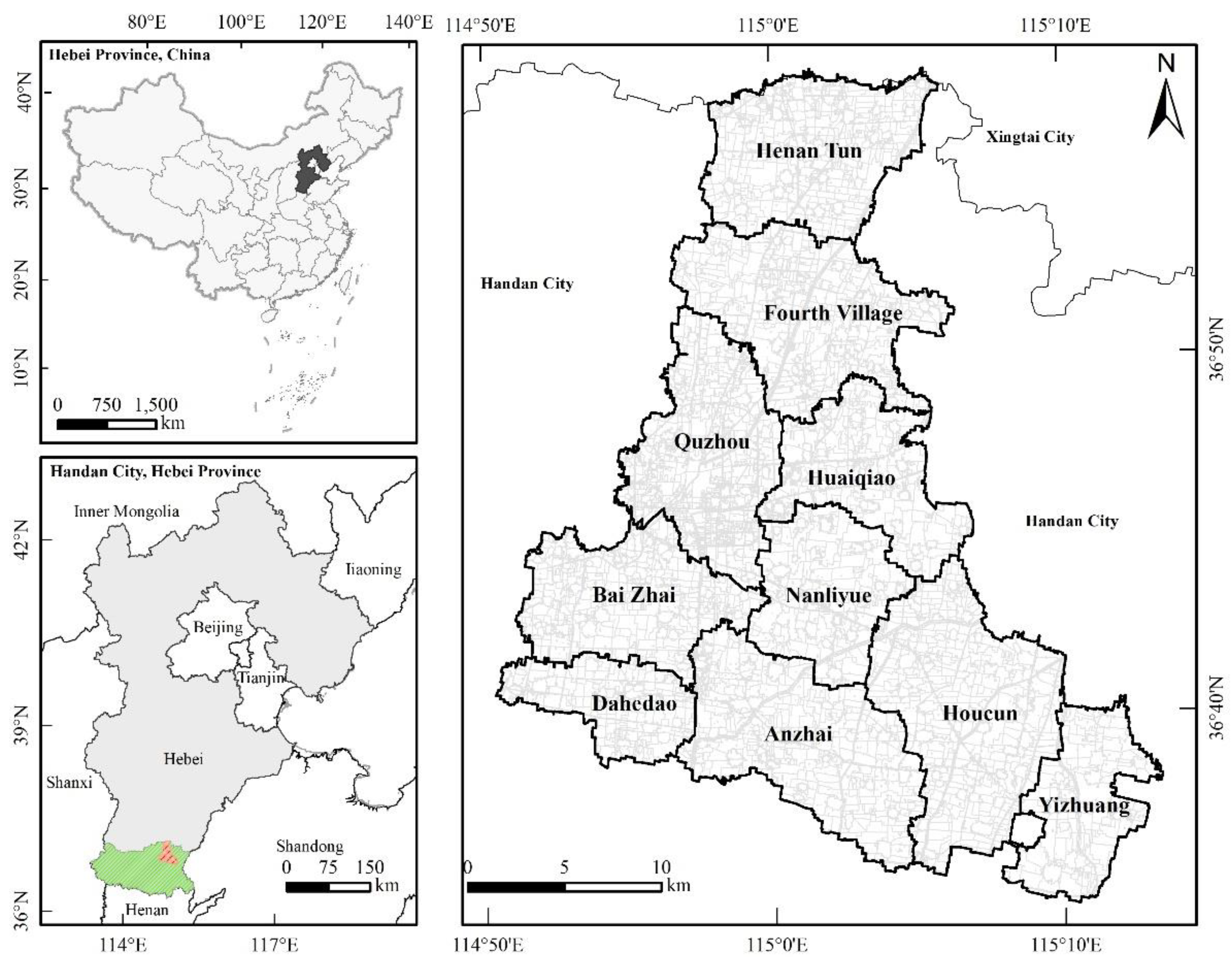
Figure 2.
Flowchart for Classifying Rural Landscapes through the Integration of Subjective and Objective Criteria.
Figure 2.
Flowchart for Classifying Rural Landscapes through the Integration of Subjective and Objective Criteria.
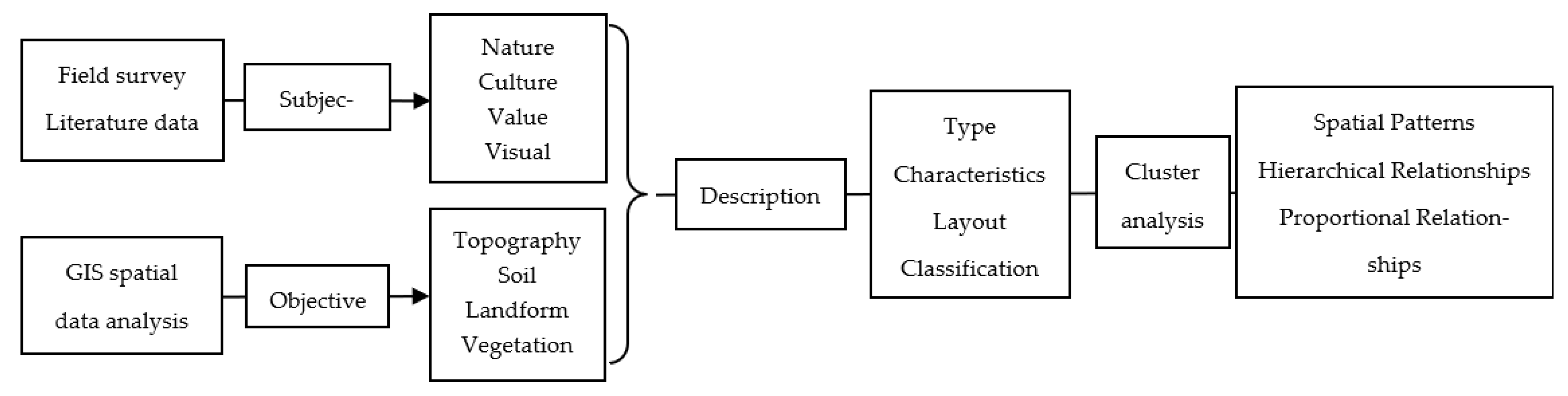
Figure 3.
Spatial-Temporal Evolution Characteristics of Rural Sexuality in Quzhou County, 1985–2015.
Figure 3.
Spatial-Temporal Evolution Characteristics of Rural Sexuality in Quzhou County, 1985–2015.
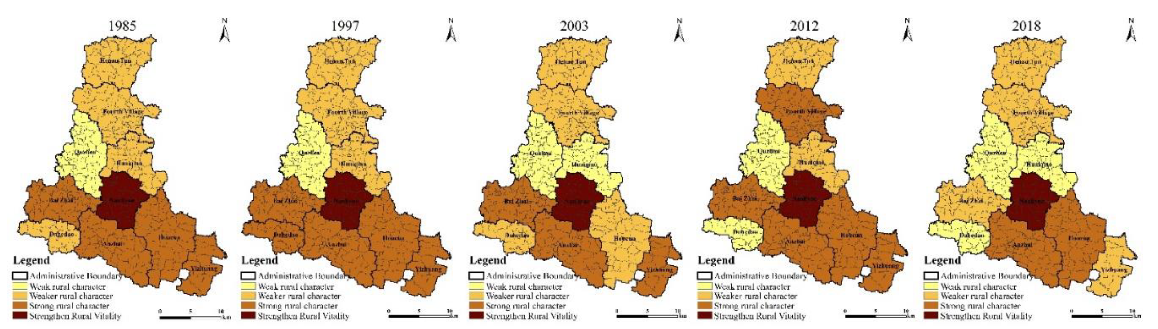
Figure 4.
Spatial-Temporal Distribution Characteristics of Rural Sexual Hotspots in Quzhou County, 1985–2015.
Figure 4.
Spatial-Temporal Distribution Characteristics of Rural Sexual Hotspots in Quzhou County, 1985–2015.
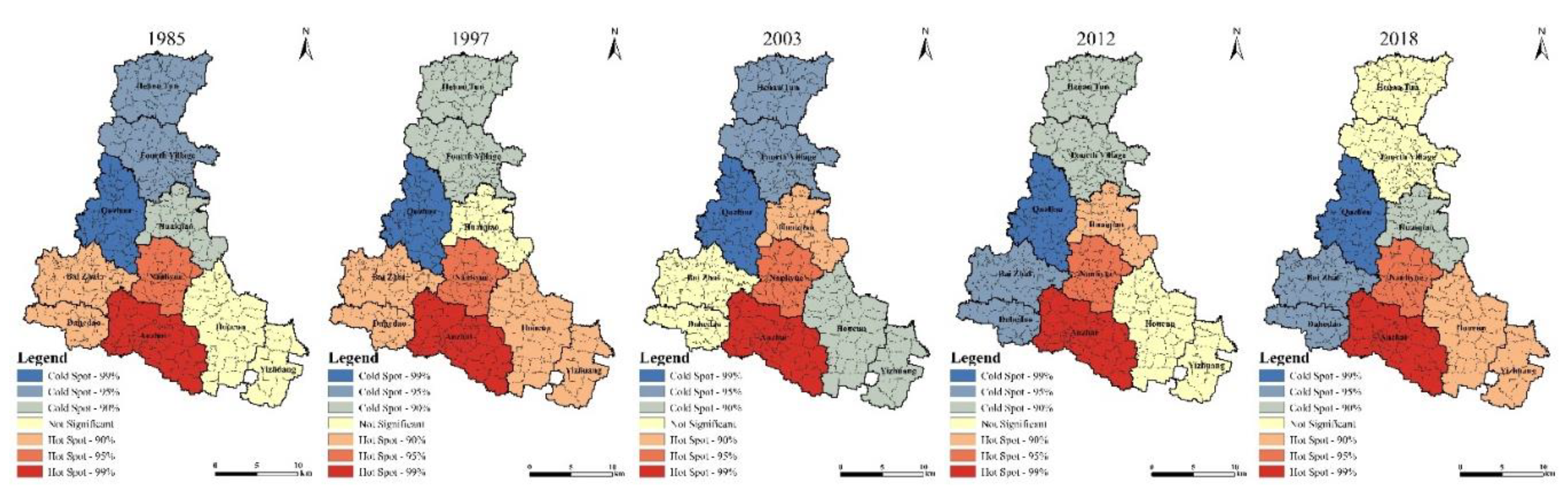
Figure 5.
Classification of Rural Objective Landscape Types.
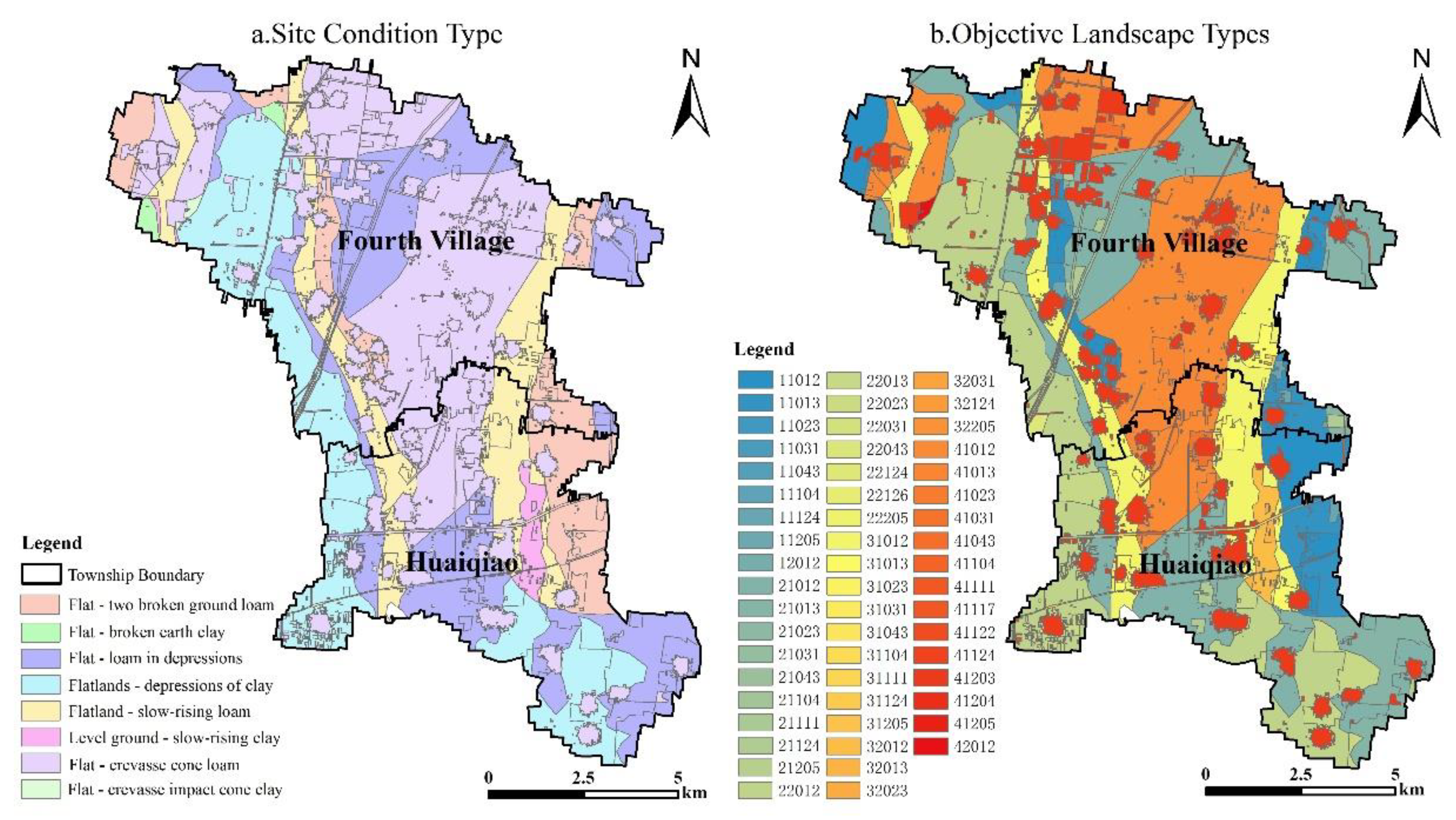
Figure 7.
Comparison Map of Land Use Status Changes in Quzhou County between 1985 and 2015.
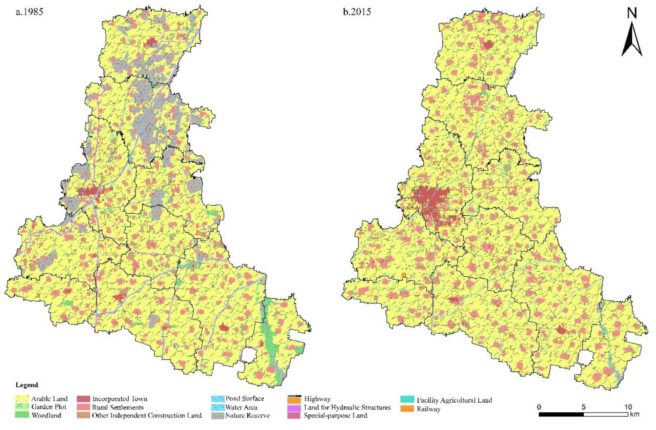
Figure 8.
Patterns of Evolution in Rural Family Structures.
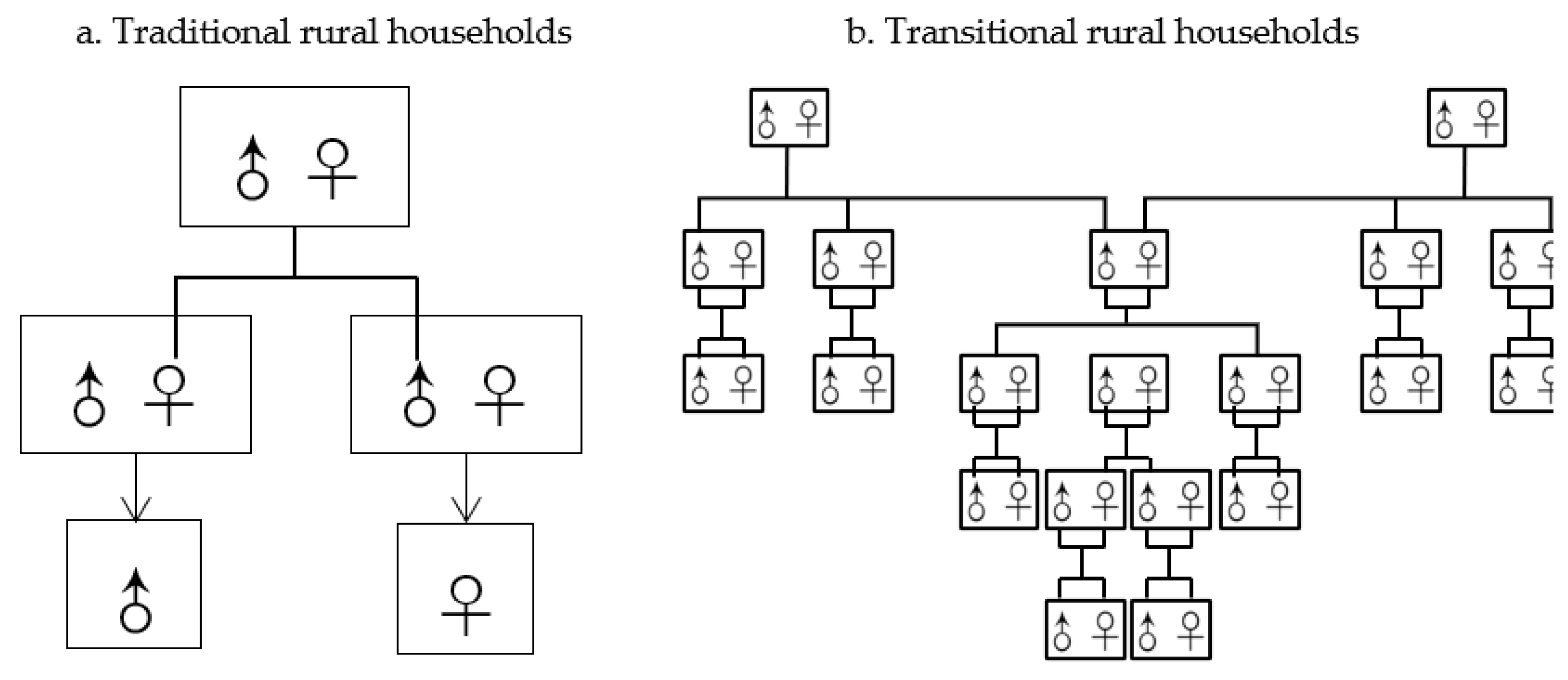
Table 1.
Remote sensing data parameters employed in the study area.
| Sensor | Spatial Resolution (metres) | Time Coverage | Purpose |
|---|---|---|---|
| Landsat TM/ETM+/OLI | 30 | 2000, 2010, 2015 | Long-term Land Use/Land Cover Change Detection |
| Sentinel-2 | 10–20 | 2017–2020 | Fine-scale landscape classification and vegetation index analysis |
| GF-1 PMS | 2(Full colour)、8(Multispectral) | 2015 | Interpretation of Village-Level Spatial Patterns |
| DEM | 30 | 2000, 2010, 2015 | Terrain and Gradient Analysis |
Table 2.
Framework and Data Sources for Rural Sexuality Assessment Indicators.
| Evaluation Dimension | Core Indicators | Data Sources | Rationale |
|---|---|---|---|
| Demographics | Population density, agricultural population proportion | Statistical yearbooks, field surveys, etc. | Quantify rural population structure characteristics |
| Economic | Primary industry share of GDP, per capita agricultural income | Statistical yearbooks, agricultural statistical ledgers, etc. | Analyze the impact of economic structure on rurality |
| Spatial | Per capita arable land area, settlement density | Land use maps, statistical yearbooks, etc. | Examine settlement spatial structure characteristics |
| Functional | Productive, living, ecological, and cultural functions | Remote sensing images, questionnaires, etc. | Support multidimensional interactions of rural multifunctionality |
Table 4.
Global Moran's I value for the Rural Sexuality Index in Quzhou County.
| Year | Moran's I | P-value | Z-score | Variance |
|---|---|---|---|---|
| 1985 | 0.0092 | 0.7414 | 0.3301 | 0.1330 |
| 1997 | 0.0738 | 0.6124 | 0.5067 | 0.1332 |
| 2003 | -0.2605 | 0.5859 | -0.5449 | 0.0752 |
| 2012 | -0.0792 | 0.5096 | 0.1135 | 0.0792 |
| 2015 | 0.1948 | 0.4212 | 0.8043 | 0.1446 |
Table 5.
Comparative Validation of Subjectively Perceived Visual Landscapes and Imaginal Landscapes.
Table 5.
Comparative Validation of Subjectively Perceived Visual Landscapes and Imaginal Landscapes.
| Category | Imagery Landscape Elements |
|---|---|
| Living
Landscape Elements |
Dew, morning mist, cooking smoke, fishing, rice jar, cock crow, bird song, tomb, fallen leaves, woodcutter, rural elders, elderly man, farmer, mountain visitor, fisherman, old fisherman, old man, village child, agricultural laborer, shepherd boy, carrying hoe, weeding, farming, reclaiming wasteland, grazing, joint plowing, butterfly, dragonfly, dog, cow, sheep, wasp, swallow, calf, firefly, ox, crow |
| Production
Landscape Elements |
Vegetable garden,rural field, farmland, wheat field, field ridge, open field, hemp, crops, bean seedlings, buckwheat flower, rapeseed flower, rice seedling, wheat, vegetable bed, Malabar spinach, rice, Chinese cabbage |
| Ecological
Landscape Elements |
Woodland, chrysanthemum, weeds, courtyard tree, solitary pine, mulberry tree, poplar, elm, willow, peach tree, plum tree, apricot flower, green grass, mugwort, orchid, tender grass shoots, old tree, apricot tree, pond, pond, slope |
| Infrastructure Landscape Elements | Village outer wall, threshing ground, house, narrow road, courtyard, small garden, simple house, fence, thatched cottage, yard, well, stove, firewood door, ancient temple, bird's nest, stone bridge, thatched house, slope road, gate tower, farmyard, granary, water pavilion, cowshed, chicken coop, thatched hall, thatched pavilion, small earthen fort,door, fence, roller,well sweep,plow tool |
Table 6.
Conceptual Definition of Rural Landscape Areas.
| Landscape Zone | Key Components | Definition and Characteristics |
|---|---|---|
| Rural Settlement Landscape Zone | Villages, designated towns, special-purpose land, and mining land | Predominantly consisting of rural settlements, primarily providing residential spaces for village populations and ancillary facilities under specific environmental and specialized production conditions |
| Rural Facility Landscape Zone | Rural roads, urban-rural highways, and agricultural facility land | Provides service-oriented facilities for rural agricultural production and landscape amenities with recreational and tourism functions for urban populations |
| Rural Ecological Landscape Zone | Ecological woodlands, grasslands, river surfaces, pond surfaces, ditches, hydraulic structures, saline-alkaline lands, and sandy lands | Plays a significant role in ecological environment protection, with crucial ecological regulatory functions including regional water conservation, humidity regulation, air purification, and biodiversity conservation |
| Rural Production Landscape Zone | Dry farmland, irrigated farmland, orchards, and economic forests | Subject to primary artificial inputs by local residents to obtain direct economic output value, while providing agricultural products, industrial raw materials, and other agricultural commodities |
Table 7.
The correspondence between landscape groups, landscape zones and landscape types within the study area.
Table 7.
The correspondence between landscape groups, landscape zones and landscape types within the study area.
| Landscape Group | Landscape Zone | Code | Landscape Type | Perceptual Landscape Elements |
|---|---|---|---|---|
| Rural
Ecological Landscape Group |
Ecological Landscape Zone | 22031 | Depression Clay Ecological Forest Landscape | Woodland, chrysanthemum, weeds, courtyard trees, solitary pine, mulberry tree, poplar, elm, willow, peach tree, plum tree, apricot blossom, green grass, mugwort, orchid,, old tree, apricot tree, pond, pond, spring, river, pond... |
| 22043 | Depression Clay Wasteland Landscape | |||
| 22124 | Depression Clay Saline-Alkali Landscape | |||
| 22126 | Depression Clay Sandy Landscape | |||
| 21111 | River Water Surface Landscape | |||
| 31111 | Lake Water Surface Landscape | |||
| 22205 | Depression Clay Rural Ecotourism Landscape | |||
| Production Landscape Zone | 41111 | Aquaculture Water Surface Landscape | ||
| 41117 | Ditch Landscape | |||
| 11012 | Slope Loam Irrigated Farmland Landscape | |||
| 11013 | Slope Loam Dry Farmland Landscape | |||
| Rural
Production Landscape Group |
Production Landscape Zone | 41111 | Aquaculture Water Surface Landscape | Vegetable garden, wheat field, field ridge, crops, rice seedling, vegetable bed, threshing ground, well, stove, firewood door, stone bridge, gate tower, farmyard, cowshed, chicken coop, roller,ancient temple, bird's nest, shepherd boy, carrying hoe, weeding, farming, reclaiming wasteland, grazing, joint plowing... |
| 41117 | Ditch Landscape | |||
| 11012 | Slope Loam Irrigated Farmland Landscape | |||
| 11013 | Slope Loam Dry Farmland Landscape | |||
| 11023 | Slope Loam Orchard Landscape | |||
| 41122 | Agricultural Facility Landscape | |||
| Facility Landscape Zone | 41122 | Agricultural Facility Landscape | ||
| 41204 | Rural Industrial Landscape | |||
| Rural
Living Landscape Group |
Settlement Landscape Zone | 41104 | Breach Alluvial Cone Rural Road Landscape | Courtyard, fence, thatched cottage, dew, morning mist, cooking smoke, fishing, rice jar, cock crow, bird song, tomb, rural elders, farmer, village child, agricultural laborer, shepherd boy, carrying hoe, weeding, farming, reclaiming wasteland, grazing, joint plowing... |
| 41203 | Rural Settlement Landscape |
Table 8.
Table of Historical, Cultural and Scenic Value Advantages for Selected Villages in Huaqiao Township and the Fourth Tun Town, Quzhou County.
Table 8.
Table of Historical, Cultural and Scenic Value Advantages for Selected Villages in Huaqiao Township and the Fourth Tun Town, Quzhou County.
| Xiangongzhuang Village | Xiaodiba Village | Disituan Village | Gong Village | |
|---|---|---|---|---|
| Population (persons) | 636 | 820 | 697 | 740 |
| Land Use (ha) | 6.56 | 8.12 | 8.07 | 8.37 |
| Conservation Rationale | The original village morphological structure remains intact with a sound economic foundation, positioning it as a critical tourism resource through systematic planning and design. | Characterized by large population agglomeration, intensive land use, robust economic base under collective management, and pristine environment, qualifying it as a representative model village. | Clear industrial development orientation with extensive agricultural cultivation areas under county-university collaborative production model, exhibiting distinct industrial and landscape characteristics. | Possesses adequate population scale, intensive land utilization, diverse industrial development, and high richness of surrounding agricultural landscapes. |
| Renovation Measures | Renovation and upgrading as a spatially significant tourism resource cluster in the region | Renovation and development as a tourism-oriented village to establish a regional model | Implement ecological agriculture-focused development strategy to deepen county-university win-win collaboration | Ecological environment remediation combined with agritourism and tertiary industry development for rural economic advancement |
Table 9.
Measures and Reasons for Addressing Non-Intensive Land Use in Settlements of Huaqiao Township and Sìdìtuan Town, Quzhou County.
Table 9.
Measures and Reasons for Addressing Non-Intensive Land Use in Settlements of Huaqiao Township and Sìdìtuan Town, Quzhou County.
| Township | Village | Population (persons) |
Land Use (ha) | Per Capita (㎡/person) |
Intervention Strategies |
|---|---|---|---|---|---|
| Disituan Town | Bujie Village | 3130 | 16.09 | 51.42 | Develop as Central Village |
| Chengzhai Village | 2555 | 9.19 | 35.99 | Preserve and Renovate | |
| Dabadi Village | 1786 | 19.35 | 108.37 | Relocate to Surrounding Villages | |
| Dazhongzhai Village | 2365 | 14.84 | 62.73 | Relocate to Central Village | |
| Deng Village | 1097 | 6.93 | 63.21 | Relocate to Central Village | |
| Wudituan Village | 2324 | 18.87 | 81.19 | Preserve and Renovate | |
| Dongliushangzhai Village | 1720 | 16.74 | 97.29 | Develop as Central Village | |
| Dongwei Village | 1185 | 13.62 | 114.91 | Relocate to Central Village | |
| Guolizhuang Village | 1786 | 14.62 | 81.85 | Relocate to Central Village | |
| Longwangmiao Village | 990 | 11.14 | 112.54 | Preserve and Renovate | |
| Shen Village | 976 | 8.65 | 88.65 | Preserve and Renovate | |
| Sun Village | 430 | 4.49 | 104.4 | Relocate to Surrounding Villages | |
| Zheng Village | 1113 | 8.80 | 79.04 | Preserve and Renovate | |
| Huaiqiao Township | Guozhuang Village | 1940 | 22.45 | 115.70 | Integrate to Form Central Village |
| Houguanzhai Village | 1373 | 14.38 | 104.68 | Develop as Central Village | |
| Jinzhuang Village | 1070 | 9.34 | 87.18 | Preserve and Renovate | |
| Liuguotun Village | 1822 | 18.20 | 98.97 | Preserve and Renovate | |
| Liuwangzhuang Village | 1994 | 22.18 | 111.22 | Relocate to Central Village | |
| Qianguanzhai Village | 1237 | 12.25 | 98.97 | Relocate to Central Village | |
| Yanglizhuang Village | 1834 | 12.13 | 66.13 | Preserve and Renovate |
Table 10.
Measures for Addressing Non-Intensive Land Use in Settlements of Huaqiao Township and Sìdìtuan Town, Quzhou County.
Table 10.
Measures for Addressing Non-Intensive Land Use in Settlements of Huaqiao Township and Sìdìtuan Town, Quzhou County.
| Township | Village | Population (persons) |
Land Use (ha) | Per Capita (㎡/person) |
Intervention Strategies |
|---|---|---|---|---|---|
| Disituan Town | Beilongtang Village | 749 | 37.86 | 505.83 | Develop as Central Village |
| Liutuan Village | 512 | 46.34 | 904.74 | Preserve and Renovate | |
| Disituan Village | 154 | 75.66 | 4927.57 | Relocate to Surrounding Villages | |
| Jiaozhuang Village | 103 | 96.49 | 9364.75 | Relocate to Central Village | |
| Matuan Village | 898 | 51.67 | 575.37 | Relocate to Central Village | |
| Quzhou County Farm | 556 | 153.91 | 2770.19 | Preserve and Renovate | |
| Huaiqiao Township | Qiaobao Village | 567 | 31.46 | Integrate and Upgrade | Integrate and Upgrade |
| Xizhangtou Village | 508 | 32.06 | 630.93 | Integrate and Upgrade |
Table 11.
Farming radius determined by different modes of transport (Unit: km).
| Electric Bicycles | Electric Tricycles | Motorcycles | Agricultural Tricycles | |
|---|---|---|---|---|
| 5 min | 0.8 | 0.8 | 1.6 | 1.6 |
| 10 min | 1.6 | 1.6 | 3.3 | 3.3 |
Table 12.
Indicator Hierarchy.
| Target Layer | Criterion Layer | Weight | Indicator | Weight | Composite Weight |
|---|---|---|---|---|---|
| Central Village
Suitability A |
Production
Conditions B1 |
0.48 | C11 Farmland Fragmentation Degree (patches/km²) | 0.53 | 0.25 |
| C12 Trunk and Township Road Density (m/km²) | 0.05 | 0.02 | |||
| C13 Field Road Density (m/km²) | 0.04 | 0.02 | |||
| C14 Grain Yield per Hectare (kg/hm²) | 0.08 | 0.04 | |||
| C15 Settlement Density (units/km²) | 0.16 | 0.08 | |||
| C16 Cultivated Land Proportion (%) | 0.13 | 0.06 | |||
| C17 Motor-Pumped Well Density (units/km²) | 0.02 | 0.01 | |||
| Ecological
Conditions B2 |
0.11 | C21 River and Ditch Density (m/km²) | 0.75 | 0.08 | |
| C22 Forest Network Density (m/km²) | 0.25 | 0.03 | |||
| Living
Conditions B3 |
0.41 | C31 Settlement Population Size (persons) | 0.50 | 0.21 | |
| C32 Per Capita Net Income (CNY) | 0.05 | 0.02 | |||
| C33 Distance to Nearest Township (km) | 0.07 | 0.03 | |||
| C34 Transport Accessibility (km) | 0.22 | 0.09 | |||
| C35 Construction Land Area (hm²) | 0.16 | 0.06 |
Table 13.
Optimised Functional Zoning of Rural Spaces.
| Zoning Category | Villages |
|---|---|
| Priority Development Zone | Huaiqiao Village, Disituan Village |
| Key Development Zone | Wangzhuang Village, Xingyuan Village, Xiaodiba Village, Xianggongzhuang Village, Shizhai Village |
| Guided Development Zone | Deng Village, Fuzhuang Village, Guolizhuang Village, Lizhuang Village, Xinanzhai Village, Kushuibao Village |
| Restricted Development Zone | Yanglizhuang Village, Jinzhuang Village, Wudituan Village, Chengzhai Village |
Disclaimer/Publisher’s Note: The statements, opinions and data contained in all publications are solely those of the individual author(s) and contributor(s) and not of MDPI and/or the editor(s). MDPI and/or the editor(s) disclaim responsibility for any injury to people or property resulting from any ideas, methods, instructions or products referred to in the content. |
© 2025 by the authors. Licensee MDPI, Basel, Switzerland. This article is an open access article distributed under the terms and conditions of the Creative Commons Attribution (CC BY) license (http://creativecommons.org/licenses/by/4.0/).
Copyright: This open access article is published under a Creative Commons CC BY 4.0 license, which permit the free download, distribution, and reuse, provided that the author and preprint are cited in any reuse.


