
Submitted:
28 September 2025
Posted:
29 September 2025
You are already at the latest version
Abstract
Urban morphology is a multidisciplinary field of study that focuses on the physical form and structure of cities. It draws researchers from various fields, including geography, architecture, urban planning, sociology, and anthropology. The diversity of perspectives has led to a better understanding of the complexities of urban morphology but has also given rise to misunderstandings and debates. The study aims to investigate the various schools of thought and methodologies that have developed to analyze and comprehend urban morphology. The findings suggest that the conceptual qualitative tools provided by urban morphogenesis can be used in conjunction with the quantitative tools proposed by urban morphology theories at the level of various concrete forms. The integration of different approaches can lead to a more comprehensive understanding of urban morphology. This can aid in decision-making in urban planning and design. The study highlights the importance of interdisciplinary collaboration in addressing complex urban issues. It also emphasizes the need for ongoing dialogue and debate among scholars to advance knowledge in this field.
Keywords:
urban fabric
; morphology
; morphogenesis
; dynamic
; statics
1. Introduction
There has been a growing recognition of the importance of studying urban form in recent years[1,2,3]. Urban morphology is an interdisciplinary field that includes urban sociology, archaeology, architecture, architectural history, geography, history, landscape architecture, and planning. To better understand human settlements, urban morphology undoubtedly necessitates interdisciplinary research [4]. The ability of early scholars in this field to read across disciplines was unrestricted. Disciplines tightened their structures and increased their publication output in the second half of the twentieth century. This reduces settlement knowledge. To address this issue, urban morphology researchers will need to conduct interdisciplinary research.
Despite common challenges, research into urban morphology has advanced in recent years. The field is expanding as a method for studying and transforming urban environments. As a result, understanding the definition of urban morphology is critical for anyone interested in the subject. Researchers in this field examine urban areas using a variety of methods, including GIS mapping, archival document analysis, and on-site observation, to name a few [5]. Understanding cities and their evolution is aided by urban morphology and we can expect to see even more advances in our understanding of the built environment as the field grows.
Among the many disciplines, we could say that geography and architecture shaped the study of urban form in the twentieth century which can help us understand the evolution of cities and the decisions made about their design [6]. However, many challenges must be overcome in order to make progress in this field. Some of these issues are poor communication across disciplines, a lack of comparative studies, a lack of links between research and practice, and the influence of a discipline's past on its progress. But, if we can overcome these challenges, the study of urban form can be a valuable tool for understanding the evolution of cities and how they are changing today[6].
Most urban projects rely on analytical studies with geographical and architectural approaches, and they are limited to the tools of traditional urban morphology schools[7]. This strategy frequently ignores other intangible factors that can contribute to the success or failure of urban projects. The social aspect has an undeniable influence on the physical layout of the city [8] . This influence can be understood on two distinct levels: the visible and tangible (explicit), and the hidden and intangible (implicit). With this viewpoint, it is critical to investigate the morphology of the city using a more comprehensive method that integrates the social and physical forms. And we wonder what tools the various schools of thought offer. How can a new approach to urban studies be developed that integrates physical and social form research? Can the outputs of the Urban Sociology School (such as the Chicago School) be used to explain the dynamics of a city in addition to its physical form?
2. Material and Method
This paper makes use of traditional (narrative) literature review, which is to comprehensively review and analysis of existing literature on a particular topic. It typically identifies gaps in existing research and evaluates the quality and value of research[9,10]. Therefore, we make no claim throughout this research that we are conducting exhaustive research on all theoretical aspects of Morphological Urban Schools. However, we aim to provide a one-of-a-kind reading that combines the perspectives of the founders of the traditional school of urban morphology and the pioneering Chicago school of urban sociology. We believe that studying urban morphology with a static approach, which relies on open and closed maps and shapes (along with many analytical tools), combined with a dynamic approach, which complements the previous ones and proposes models of the spatial organization of the city generated by processes linked to individual or group mobility, can provide a clearer overview and a more rigorous study of the urban fabric. This selective review, we believe, will be useful as an integrated methodology for studying urban morphology.
3. The Urban Morphology in Question
The concept of morphology can be dated to the ancient age, particularly among the Greeks. Two aspects of thought have been developed and form the basis of the Western morphological tradition – the description of the components of form in a whole/part relationship and the idea of evolution; that is, of the dynamics of forms[11]. From the beginning, space and time were recognized as two fundamental attributes of morphology, hence the idea of a "chain of being" resulting from the historical approach in the middle of the 18th century which placed emphasis on the sequence of forms across time: past, present and future[12].
The term morphology comes from naturalistic biology and concerns organic forms and their structure, namely the architecture of organisms. Later, the concept was introduced in human geography, in particular for the explanation of historical phenomena[13]. The use of the term morphology in the field of urban has become the science that studies the form of human settlement and the processes of its formation and transformation. This science aims to understand the space occupied by people, the physical structure of the built environment and its characteristics through the examination of the motivations of formation. The physical analysis of the components of structure is often performed at different scales in order to explore open to close ratios and the way in which they are distributed in the occupied space.
There is abundant literature on urban morphology in architecture and in the planning theory that derives from it. Prior to the 1960s, this tradition was largely prescriptive and utopian regarding the elaboration of ideal cities meant to organize human settlement. Howard's garden cities of tomorrow [14], “la Ville Radieuse” The Radiant City. Elements of a Doctrine of Urbanism to be Used as the Basis of Our Machine-age Civilization.” proposed by Le Corbusier [15], or the design of Broadacre model designed by Wright “When Democracy Builds” [16] are notable examples. The criticism of the 1960s developed more analytical approaches to the urban form seeking to reconstitute an order underlying what some call “urban disorder” and to maintain the integrity of the urban form[11]. In this last perspective, urban morphology constitutes a field of knowledge essentially concerned with the structure of the urban form [17], and which should contribute to the practice of the design of this form [18].
Larkham argues that understanding the physical complexities of the different scales – buildings, lands, and streets – that make up the structure of cities helps us understand how cities have grown and developed. Qualities of place are often attributed, in large measure, to physical characteristics such as size, scale, and the relative relationships between different elements. This knowledge helps us to appreciate what is successful or not, and to provide structural elements for future forms [18].
The most prominent exponents of the critique of utopian approaches were Lynch [19], Jacobs [20], and Alexander [21], who proposed a more humane approach to urban planning, based on observing what actually works in existing cities as characteristics or physical design. Alexander's work, for example, introduced formal mathematical concepts into the debate over shapes. A series of subsequent works in urban morphology have focused on what works and what is possible to achieve in the field of urban planning[22]. All of these works, and many others[23,24], have relied on “mathematical tools” including graph theory and set theory to produce more refined representations of urban form that can be useful for planning. These led to the development of what has been called "space syntax"[25,26] as models for the formal representation of relationships between forms, based on structural measures, to describe the structure of a city.
Human geography research is also well-established. In the Anglo-Saxon world, they are rooted in the German tradition of “Kulturlandschaf “ the cultural landscape inaugurated by the geographer Whitehand [18]. His work provided an explanatory morphology based on the relationships between form, function, and development. Sauer [13] coined the term “landscape morphology” to describe a synthetic approach to form that identifies the structural elements of cultural landscapes and organizes them by development sequences. Conzen [27] views urban landscapes as a mirror that reflects society's functioning. Their material forms reveal the various needs of society and its populations, such as housing, work, transportation, and leisure. When these needs change, the urban landscape, in turn, changes.
Raymond Ledrut [28], who introduced new registers of form and studied the relationships between form and meaning, social morphology and semiology, developed a social approach in French-speaking countries. He was led to create an inventory of forms, such as form-scheme, form-object, form-machine, form-quantity, form-sign, aesthetic-mathematical form, form harmony, functional form, symbolic form, while establishing their correspondences with space, which is also defined as space-structure, space-extent, organic-space, cultural space, and specifying that we cannot evoke any social form without questioning space.
A typology of cities, according to Albert Levy, can thus only be integrated into a typology of social forms and "social spaces." It remains to be seen how these forms and spaces interact. There are numerous approaches to dealing with the city and its space: as an expanse, a population, a work, a symbol. One must attempt to connect these elements and discover their unity[29].
Accordingly, Roncayolo insists on the view that morphology is also social, since it studies the distribution of settlement, the distribution of social groups and the deployment of their movements. Material forms being social constructions and places of practice, they can only be properly understood from transversal and multidisciplinary approaches[30].
A city, according to Park, is "a spatial organization of social groups." He contends that a city is made up of more than just buildings and people, but also of how space is organized within it. Individual or group positions within the city express this morphology. The spatial organization of the city is the result of self-organizing forces[31]. Urban morphology to Carmona, is the study of the relationship between form and urban space, and it provides information to urban planners and architects to help them become familiar with local patterns of development and the processes by which those patterns are altered[32].
Morphology is the study of the form and structure of entities in its broadest sense. Urban morphology is concerned with the evolution and transformation of cities over time in the context of cities. Urban morphologists study the evolution of a city, from its early years to its subsequent transformations. This could include investigating the physical layout of streets and buildings, as well as the social uses of space and the symbolic meaning of urban places. Urban morphologists can gain insight into a city's current form and potential future development by understanding how it has evolved.
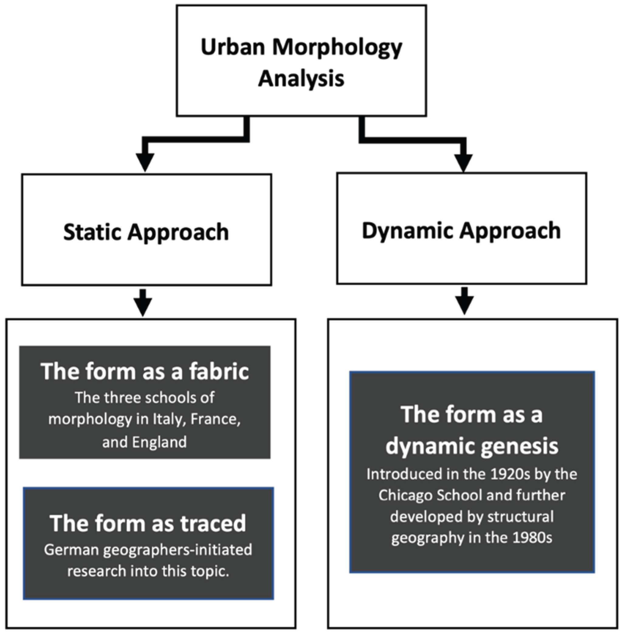
From these different research perspectives, we understand that urban forms are objects constructed from a hypothesis or a point of view that we can categorizing as following : first, the form as a fabric whose analysis is developed by the three morphological schools, Italian and English as well as the French; second, the form as traced, the study of which was initiated by German geographers; finally, the form as a dynamic genesis introduced by the Chicago School in the 1920s and more recently deepened by structural geography [33]. In the remainder of this study, we will explain, examine, and discuss each of these three approaches to better understand chronological development of the concept of urban morphology (Figure 2).
Figure 1.
Urban morphology analysis approaches.
4. Results and Discussion
The analysis of quantitative and qualitative outputs of schools of thought concerned with urban morphology is crucial for comprehending the urban fabric. These outputs provide important tools for understanding the physical, social, and economic aspects of urban areas. Together, these approaches provide a comprehensive understanding of the complex nature of urban environments and can inform policy decisions related to urban planning and development.
4.1. The Three Schools of Urban Morphology
Numerous studies have been conducted on urban morphology. Moudon and many other language researchers divide them into three major schools: British, Italian, and French [34]. It is impossible to discuss the many aspects of urban morphology, such as geography, architecture, and urban design, without mentioning these schools of thought, which reflect different types of research; thus, such a classification is critical. The three major schools of urban morphology in Europe have proposed conceptual tools for rationally describing the built environment. They are the University of Birmingham research group, which is based on Conzen's work; the Italian school, which is based on the work of Saverio Muratori; and the French school of Versailles, which is based on the work of Castex and Panerai.
Driven by heritage concerns, the physiological approach initiated by Conzen [35] mainly favored the study of small towns of medieval origin in England before extending to more complex urban forms. The method consists of dividing the entire urban fabric into systems and studying them separately before analyzing their interactions. Four systems are recognized as being relevant: the parcel system which divides the land into units of land ownership; the street system that allows movement between the plots; the built system, i.e., all buildings regardless of their function or form; and the system of open spaces, space not built and not included in the street system, whether public or private. The plot and road systems form a coupling called the “mode of distribution” of urban space, while the systems of buildings and open spaces form a coupling called the “mode of occupation” of the urban territory. The first occurs in a two-dimensional space while the second requires a three-dimensional representation. At the level of buildings, only the large volumetric variations are considered, the detailed analysis of the various constructions not being the object of this type of analysis.
Furthermore, a priority of the analysis relates to the persistence or the lifetime of the elements which are part of each of these systems. In the case of the urban plan, these elements tend to oppose a strong resistance to the changes. For example, the very numerous and very old networks of paths through the urban area that are still visible in the landscape today. The use of the ground and the uses of the built forms, on the other hand, tend to be much more ephemeral, the building being in an intermediate position in its resistance to change. Four distinct processes are considered to study these changes. What Conzen [35] calls “accumulation” concerns the introduction of new urban forms during successive historical periods, and which fit into existing fabrics because they meet the needs of the inhabitants. Adaptation, on the other hand, is the way in which old forms are modified while retaining their usefulness when needs have changed. Transformation is a change caused by the existing urban form while replacement is the substitution of existing forms by others under the pressure of new needs [35].
The study of these change processes affecting the systems identified by morphological analysis results in the production of maps delimiting the "morphological regions" or landscape units of a city that can be ranked according to their historical origins and types of resistance to change, providing the opportunity to visualize a community's cultural identity. Since Conzen conducted his study of Alnwick [36] and published it in 1960 i.e., in the past 60 years his school of thought has advanced considerably. Journal of Urban Morphology is a good starting point.
The British approach is a theory that contends recent urban changes are not entirely new occurrences, but rather the continuation of previous alterations processes. This is the cornerstone of the British strategy. As a result, the British school of thought conducts its research on urban morphology by taking into account specific study domains and following a predetermined methodology. Meanwhile, it considers the existing circumstances, as well as the process of change [37].
The Italian school of typo-morphology developed during the 1960s from the pioneering work of Saverio Muratori [38] in his study of Venice and Rome. The approach intends to combine the study of urban morphology and that of architectural typology in order to think in terms of the relationship between the urban form (road network, plots, boundaries, etc.,) and the typology; that is, the types of construction (position of the building in the plot, internal distribution, etc.), one type being obtained by the search for co-presence, invariants, on the one hand, and deviations and variations on the other, in the features of the building and the urban form.
Typo-morphology is intended as a response to the crisis of the modern movement in architecture. While the latter disregarded the history of the place, the approach proposed by Muratori is an attempt to reintegrate the history inscribed in the form of the building, in the street and in the plot, within the process of design, an "active history" which, starting from the breakdown of types of urban fabric, is capable of guiding the choices of the present for a long-term project[39]. Going back in time, the “historical parcellography” developed by Muratori is inspired by the descriptive methods of archeology by applying them to the field of art history, traditionally dominated until then by archival scholarship. It leads its author to describe the typologies of habitat as generators of urban forms and to sketch through this an analysis which reconnects with the tradition of "embellishments" and then "aesthetics of cities" which had dominated the thought of the 19th century. For Muratori, an understanding of history is therefore a prerequisite for the project and this principle will strongly influence the thinking of his followers: Aldo Rossi, Carlo Aymonino, Vittorio Gregotti and Gianfranco Caniggia [40].
According to Aldo Rossi, indeed the architecture of the city is that of its form which seems like a summary of the total character of urban objects, including their origins [41]. His criticism of functionalism and organicism is clear, where he asserted “Functionalism and organicism, the two main currents that have penetrated modern architecture, reveal their common roots, the reason for their weakness, and their fundamental ambiguity…the urban type is reduced to a simple scheme…of thoroughfares, and the architecture is considered to have no autonomous value” [41]. There is a dialectical relationship between the typology of material objects that make up the city and history as a revelation of shared values. Rossi sees the city as a collection of material objects, man-made material objects, which are built over time. In addition, he views history as the study of the actual formation and structure of urban objects, which is a synthesis of shared values.
The type, according to Muratori, is built from the relationships between the elements of the plot, the street network, and the built and unbuilt fabrics. The type he explains is "something permanent,” a logical principle that exists within and which constitutes the form [38]. Types for Muratori and his followers aid in explaining the continuity of the urban structure, with its permanent characteristics and distinct identities. They transmit shared values over time and shape and direct the city's future, contributing to its evolution. Similar to Rossi, where the built environment reveals society; the urban form is a result of the history and memory of its inhabitants; each place is unique and has its own identity.
The Italian school of urban morphology examines what is happening by examining types in the city's tissue. This approach aids in understanding how cities have evolved and changed over time, with special attention paid to different neighborhoods that are evolving differently even though they are participating equally in the growth around them; understanding these differences can also tell us something about why one area may be more prosperous than another—or whether some change has been for the better or for the worse.
The French school of Versailles, led by architect Jean Castex, sociologist Jean-Charles Depaule, and architect-urban planner Philippe Panerai [42], adopted certain theoretical concepts from the Italian school of thought as responses to modernism. Nonetheless, intelligent debate about urban life influenced the development of inventive architecture. It was also linked to the harsh criticism of sociologists such as "Henry Lefebvre."
The French approach to urban morphology is then informed by sociology as well as architecture. This two-sided perspective leads to a number of goals, including a strong connection with sociological sciences, an examination of how people and their environments are linked in two ways, and the discovery of a way to discuss design theory in both theoretical and practical terms [37]. This way of looking at things has resulted in some significant discoveries, such as the fact that cities are not only physical places, but also social creations. This point of view has also demonstrated the importance of considering how urban spaces function and appear.
Due to the examination of various models and theories, the French school of thought does not believe in any distinction between "before" and "after." It considers how an idea affects patterns, types, and forms in relation to one another. The most significant feature is its consideration of theories of urban form creation. Because traditional morphological analysis cannot explain modernism and its new spatial concept, the French school of thought developed its own framework to incorporate observational and perceptual studies [37].
Panerai and Castex write in their book Urban Forms: The Death and Life of the Urban Block [42], French architects conducted methodological-morphological experiments. Urban planners continued to believe that the magic of planning was based on large scales, and sociologists who sought out city residents and criticized bulldozer restoration swayed numerous political factions. They consider the consequences of this type of refurbishment to be equivalent to dismissal [42]. As a result, it is clear that the impact of French renovations established and clarified a collection of scholarly ideas on the theme of urban form.
Panerai and Castex developed the "Island" concept as a critical component required to study the city of the twenty-first century because modernism and its new spatial concept cannot be understood through traditional morphological analysis. As a reaction to Modernism's negative effects, the concept of "Island" provides an alternative approach to morphological studies' deficiencies in the third dimension. As a result, the French school of thought developed its own framework for incorporating perception and observational studies [43].
Before concluding this section's analysis, we compare each school's Theoretical foundation, Main purpose, Approach, and Early Pioneers using a comparison chart.
The three schools of urban morphology, the contributions of which we have just summarized, without a doubt constitute important tools in the training and practice of architects and urban planners (Table 1). Nevertheless, several criticisms have been voiced [43,44]. Such criticisms are based on an old conception of the city, described by some as nostalgic, which above all refers to a dated – and therefore obsolete – functioning and form of the city. For example, spatial continuity, parcel divisions, and streets are not understood in the same way in the old city as they are in the modern one, especially in view of its metropolitan transformation. Such approaches cannot then be suitable for objects as different as the traditional city and the new metropolitan reality, where the connection to transport networks matters more than the contiguity to the built front and where the investment cycles of real estate capital follow, as well as the influence of logic that was not present in the traditional city. Accordingly, some believe that the interest of these morphological analyses is limited to the description of urban forms and cannot be an instrument of their realizations which are part of a context study and not in an urban project.
4.2. The Dynamic Approaches to Urban Form
The theoretical approaches presented thus far address the issue of urban forms from a static standpoint, each favoring classification or typology in order to propose tools for intervention in the built fabric in their own way. They are thus primarily taxonomic and descriptive, even if some are interested in genesis processes but limit their research to history or economic production modes. One particular limitation of this approach is that it does not allow for the prediction of the effects of an intervention on the surrounding territory, assuming that what is desired is a transformation of form rather than a change in function. Another shortcoming is that these approaches frequently fall into the trap of essentialism, attempting to identify those elements that constitute the "essence" of a city and are thus unalterable. Finally, it should be noted that the majority of these theories are developed from a Eurocentric viewpoint, making them difficult to apply to non-Western contexts. As a result, theoretical frameworks that can account for the dynamic and complex nature of cities, as well as their geographical and cultural specificity, are required.
This section will supplement those by proposing models of city spatial organization generated by dynamic processes related to individual or group mobility. Both dynamic and explanatory approaches to space occupation will be used for the appropriation and development of these spaces. We begin with the work of the Chicago School, whose authors were among the first in the first half of the twentieth century to develop genesis models. We then turn our attention to more recent theories, such as the structural theory of urban morphogenesis, whose original concepts deepen and enrich the previous theories' intuitions and hypotheses. Understanding these theories allows us to gain a more complete understanding of how cities are organized and evolve over time.
4.2.1. The Chicago School
The Chicago School [45,46,47] considers the city a human community, where people, institutions, and space are interdependent. The city's social mechanism places people far from their homes. The development of the city's districts, which leads to a configuration, and the complexity of population movements for space occupation are spontaneous, unplanned external processes. Self-organized processes resemble life formation.
No social class or group dominates space layout in the Chicago School's city. The city is organized by self-organizing processes like living things, not impersonal social forces. Chicago School authors use animal and plant ecology terms. A "super-organism" city considers society and space. It considers the impact of space on individuals and institutions. It means studying how space and cities affect social group formation. Robert Park, leader of the Chicago School, says people can affirm and reproduce their lifestyles through urban space. Large cities, with more selection and segregation, have morphological characteristics not found in smaller populations[31,48].
Park says urban planning distinguishes a city from a village or small town. The city isn't buildings and people. It's space-organized, giving the city individual or group positions. In this way, society's morphology depends on individual relationships. We can only understand social ties by studying this type of organization, positional relationships in the city. Competition regulates positional relationships despite socioeconomic, cultural, project, and action differences. This phenomenon resembles animals and plants fighting for life [49].
Prestigious businesses, political power institutions, and large company social centers will occupy the city's most coveted areas and strategic positions, creating urban organizing centers. Residential habitat distribution appears subordinate to land appropriation but follows similar laws. Light industries around the central business district polarize modest residential neighborhoods for workers and new immigrants. Wealthier social strata live in single-family homes far from central congestion [49].
Park calls the city's distinct zones "natural areas" whose borders are "natural limits" because both are the result of a double process of genesis: a self-organized selection process through competition between individuals and groups for the appropriation and occupation of urban space and an integration process motivated by the affirmation of individuals' group membership. No outside actor or planner controls these processes. These processes unfold naturally, creating zones with natural, not artificial, boundaries [49]. The city's space does not match census sectors or legal and political districts. The city's space is the result of self-organizing forces that delimit zones where social groups establish themselves without official limits imposed for specific reasons.
4.2.2. The Relationship of Spatial Organization to the Economy
Park, Burgess, McKenzie, and Wirth describe competition, interaction, and association in terms of money. Land and real estate rent regulate land use competition, as do unequal opportunities for social actors to occupy the most coveted and expensive sites. Urban space competition mirrors animal ecology's "struggle for life." This appropriation seems competition- and market-regulated. The "strongest" is the one with a privileged location and the financial capacity to defeat his competitors and retain the coveted location, according to McKenzie's texts [50]. Thus, land prices reflect competition and constraint. Land and building owners no longer invest in maintaining and enhancing a pending real estate heritage, causing physical and social degradation in transition zones around the central core. Groupings are based on economics.
Chicago school competition goes beyond market-based competition. Competition means crisis, upheavals, transformations, mutations, etc. Dynamic, not linear, leading to stable equilibrium. This competitive atmosphere will inspire new mobility ideas. "Agglomeration pulse" allows spatial study of social changes. This is different from commuting or shopping. Daily, weekly, or seasonal vessel movements demonstrate a stable equilibrium. The Chicago school's mobility concerns urban space appropriation and occupation. Park: “Mobility (…) measures social change and social disorganization, because a social change is always based on a change of position in space and any social change, even that which we describe as progress, involves social disorganization” [13].
Mobility creates urban jobs through individual and group movements towards spatial occupation zones whose social content it can modify and push back. It shows the city's demographics. Mobility can affect land values and the distribution of activities and residences. "Something's happening" when land values rise or change quickly. These cities are changing. As a result, land prices aren't indicators of a stable, static distribution of activities and people. Dynamic localizations are of interest. Classical economics and the Chicago School disagree on the definition of competition. Dynamic notions of dominance, invasion, and succession that explain city configurations are not based on spatial economics' simple aggregation of individual behaviors.
4.2.3. The Models Developed by the Chicago School
The early 20th-century Chicago School developed spatial models. These models were created to study North American cities, but they're useful for understanding other large cities, especially those with high immigration. Ernest Burgess proposed a concentric model for Chicago in 1925. (Figure 8).
Figure 2.
The concentric Burgess models. Source: Redeveloped from [45].
Figure 2.
The concentric Burgess models. Source: Redeveloped from [45].
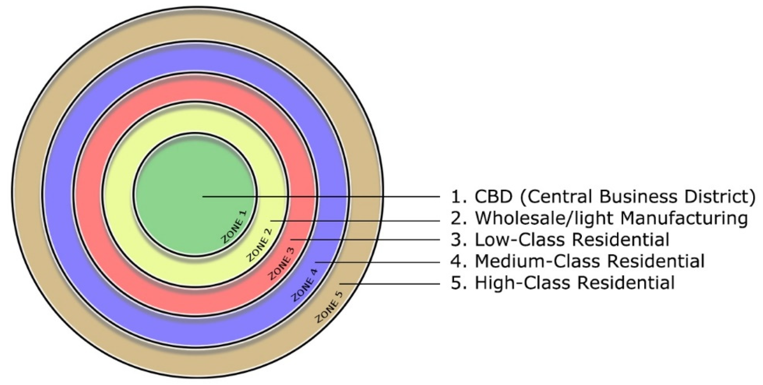
Most roads converge in Zone 1, Chicago's CBD. It includes the Town Hall, public administration, department stores, luxury hotels, theaters, performance halls, skyscrapers, and corporate and bank headquarters. 500,000 people worked there in the first half of the 20th century.
Zone 2 is a densely built, deteriorating area with poorly maintained buildings. The wealthy abandoned this area of quality buildings long ago. Land values no longer rise. Plots of land and buildings are invested in by speculators, so they fall or vary in price suddenly. The whole sector is socially unstable because industries and labor are being replaced by marginalized people living in decrepit housing. This is Hobohemia, the "tramp" district near the Loop. Here, newcomers settle, and ethnic diversity is highest. There's Little Italy, the Jewish Quarter, Chinatown, the Greek Quarter, the Polish Quarter, and “Bronzeville”, “the Black Metropolis” on Chicago’s South Side.
Zone 3 is continuously built and has a population with modest incomes but better family and community structure. Workers who left Zone 2 slums have moved into newer apartment buildings or small houses where they are sometimes owners or tenants. Zone 4 comprises luxury houses and apartments. Shopping areas, hotels, villas, and mansions abound. This is where the wealthy live and embrace the American individualistic lifestyle. There are many parks and green spaces. Zone 5 includes rural suburbs, where small estates are far from the business center and attract middle-class workers who commute daily.
Such a concentric zoning translates city growth stages and refers to a plant ecology model. In nature, resistant species colonize bare earth first. New plants gradually replace the original inhabitants. There are dominance and succession phases. The same is true for urban growth: Burgess’ model shows a succession of occupation patterns. Zone 2 initially attracted a wealthy population and dilapidated luxury buildings over time. Later, these buildings became apartments and urban parks were subdivided to house the poor and migrants.
Let's keep two ideas in mind: on the one hand, there is competition between social groups in the city for land use, and on the other hand, social belonging is reflected spatially; neighborhoods are not only distinguished by their distance from the center, but also by their occupations, which affect the social composition of the residents. Dynamically, Burgess model has:
- An attractiveness of the center. This attractiveness is due to most jobs being performed in the city center and the value of having a short commute to work.
- A process known as "invasion", which occurs as a result of this attractiveness. It is an agglomeration effect centered on the appealing center.
- The aspect of “resistance on the spot”, as a reaction to social group competition. This opposition is manifested by the assertion that individuals are members of a group. Members of groups prefer to reside together and prefer that members of other groups reside elsewhere.
- Resistance on the spot has two outcomes: if it fails, it leads to position abandonment and repression in the periphery (groups abandoning neighborhoods); if it succeeds, it manifests as adaptation on the spot and position consolidation (formation of quarters: the Greek Quarter, Bronzeville, Chinatown, etc.).
- The various concentric zones are formed as a result of such a dynamic sequence of invasion-resistance-abandonment-adaptation.
In this model, the city grows from the center outward, and it expands in all directions at the same rate. Isotropic model. In growing areas, people move to the border. Certain activities or social groups determine the city's evolution. Natural factors affect city growth. Lake Michigan limits Chicago's growth to the north, west, and south. Lakeshore areas are densely developed.
In (1939) Homer Hoyt added transportation disruptions to the Burgess model. This "sector" model describes growth and transformation by adding divergent rays, axes, or sectors. The concentric model ignored the structuring effects of transport routes on neighboring areas, with places near routes being more attractive. Hoyt adds permanence and local specialization to the previous model: neighborhoods along radial roads can develop faster. This creates a city model organized by direction (Figure 9).
Figure 3.
Hoyt's sector model. Source: Redeveloped from [45].
Figure 3.
Hoyt's sector model. Source: Redeveloped from [45].
Zone 1 is a business center, 2 is wholesale businesses and industries, 3 is working-class, 4 is middle-class, and 5 is wealthy. not duplicate Zone 5 no longer sits on the city's outskirts but enters along an attractive axis. In Chicago, this attractive axis is the waterfront property to the east of downtown, known as the "Magnificent Mile" (as well as the Gold Coast residential area to the north), home to many of the city's landmark commercial buildings: the Wrigley Building, Tribune Tower, the Chicago Water Tower, and the Allerton, Drake, and Intercontinental Hotels. Zone 2 industrial and wholesale are affected.
Hoyt's model has both a center and radial path attractiveness, with the same dynamic sequence as Burgess’ model of “invasion, resistance, abandonment, and adaptation.” It responds to social group competition. If the resistance fails, it leads to periphery repression or local adaptation. Therefore, Hoyt's model assumes the same dynamic processes that shape the city. This model is more refined than Burgess' because it introduces axes to organize and structure space. From this sectoral model, urban growth factors follow:
- Attractive high-rent areas contribute to a city's growth.
- During growth, sectors can widen and lengthen.
- When a high-rent class moves into an area, they stay for a long time.
- High-rent neighborhoods are moving outward. These sectors don't invade others. They fill empty spaces.
- When a high-rent class leaves, a low-rent class moves in.
- High-rent areas develop along the most efficient transport routes, either toward an affluent suburb or shopping centers or natural parks.
As a result, Hoyt's model complements Burgess's model. A combination of the two models, a spatial division into concentric rings within which appears a differentiation by sector, can be very useful. However, the Chicago school of thought proposed a third model. This is known as the "multiple nuclei" model. Hoyt's model proposed that a city can have multiple attractive places connected by transportation axes (Figure 10). In this sense, Harris and Ullman proposed a polycentric city scheme in 1945. With the multi-kernel model, the scheme introduced by Burgess and perfected by Hoyt becomes more complicated. The existence of three factors contributes to the development of independent centers:
- Agglomeration economies, or the clustering of similar and complementary activities in the same industry
- A distance between wealthy or affluent and underprivileged neighborhoods
- Competition for land use, certain activities, or certain social groups not having the means to afford more advantageous locations.
Figure 4.
The multiple nuclei model of Harris and Ullman. Source: Redeveloped from [45].
Figure 4.
The multiple nuclei model of Harris and Ullman. Source: Redeveloped from [45].
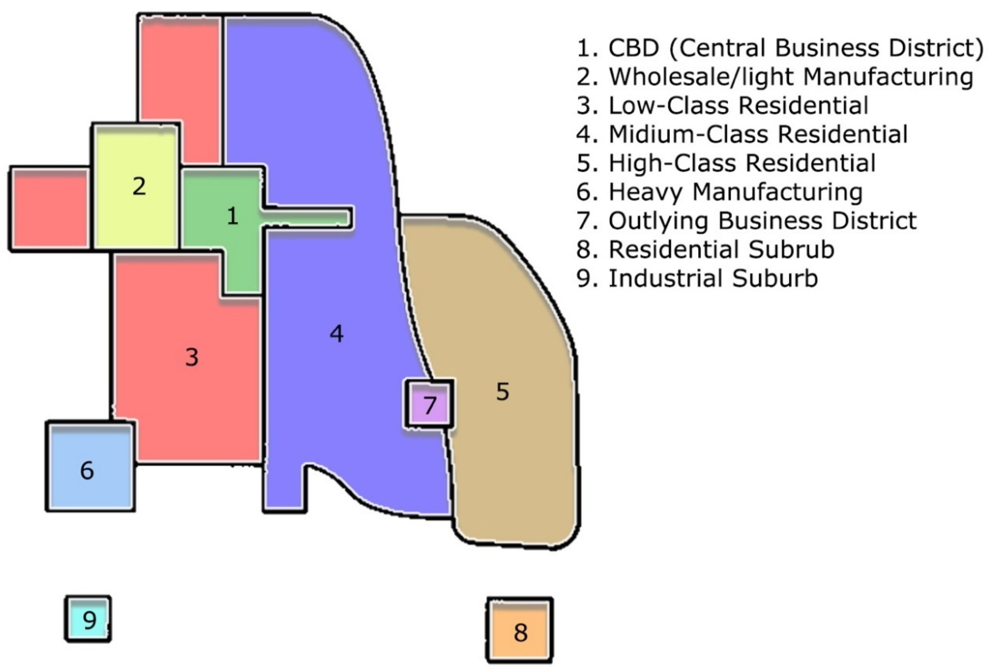
In Harris and Ullman's model, there are several appealing centers: well-defined places as well as specific axes aligned with transport routes, resulting in greater sector differentiation. However, the same dynamic processes are always at work: the invasion-resistance-abandonment-adaptation sequence.
The three Chicago school models generate the city's abstract spatial structure. In these models, urbanites' mobility isn't random. It follows privileged directions: centripetal from periphery to center (invasion) and centrifugal from center to periphery (succession). Collective representations of group membership and rejection govern cultural and social grouping. Because of their mobility, ethnic communities and social groups expand in the city. Spatial positions determine social groups' existence. They can assert themselves and rearrange because they're stable [48,49,50].
Many global cities have been studied using these three models (Paris, Rome, Montreal) [50,51,52]. They're also used together to analyze complementary city aspects. In this case, concentric zoning areas help understand the distribution of people from family status statistics, while sectors seem better suited to the distribution of groups by socioeconomic level and the multiple nuclei at the spatialization of ethnic communities. They remain interesting despite theoretical limits that make new morphogenesis models possible.
4.3. New Model of Morphogenesis
In the past 30 years, research on complex systems has deepened the Chicago school's hypothesis of self-organized genesis processes. According to Dauphiné [53], there are three types of complexity in urban studies: 1) structural complexity, which characterizes the emergence of spatial structures from the interactions of multiple social agents, 2) level complexity, linked to the interweaving of different scales or levels of organization, and 3) dynamic complexity, involving non-linear evolution processes that lead to unpredictability of the system's future effects, even when the factors are simple. A city can respond to all three types of complexity simultaneously[53].
Thus, researchers have used Ylya Prigogine's theory [54] of dissipative structures to show that the evolution of city systems is subject to self-organized nonlinear dynamics. Others have used Mandelbrot [55]fractal geometry to model the fragmentation of fabrics and the interlocking of scales (fractal “self-similarity”, urban fabric that looks similar at different scales) in the city. Others have relied on physicist Hermann Haken's synergetics [56] to reconstruct how multiple levels of organization weigh on the city, from the individual decisions of social agents to those of entities and collectives that govern us[57]. All these works are part of a vast scientific program that Alain Boutot called a "morphological revolution" [58]. The same applies to the theory of urban morphogenesis developed by Desmarais and Ritchot [33].
4.3.1. The Theory of Urban Morphogenesis
The concepts of urban morphogenesis come from Gilles Ritchot [59,60] structural geography, which Desmarais [50] showed could be enriched by morpho-dynamic models developed by mathematicians of morphological structures like René Thom and Jean Petitot [61,62]. This theory explains how the complexity of city fabrics (architectural forms, parcels, islets, road networks, neighborhoods) is organized by simpler hidden forms (spatial structures) generated by self-organized dynamics. As previously stated, the theory incorporates three types of complexity: structural complexity (the study of interactions between social actors for the appropriation and occupation of urban space); level complexity (the analysis of three spatial layers superimposed in the genesis of forms); and dynamic complexity (the study of three types of self-organized processes that occur over time) (anthropological, political and economic).
Desmarais and Ritchot [33] define urban form generation as a "morphogenetic pathway" that spans levels ranging from the deepest to the most visible. They are as follows:
- The investment of anthropological values in very particular organizing centers that they call “vacuums”.
- Flows or trajectories of political control of settlement mobility appropriating spaces around vacuums.
- Conflicting settlement mobility trajectories create hidden structural positions.
- The diversified valuation of these positions by the situation rent.
- the construction of concrete forms of spatial occupation stimulated by rent.
- the profitability of concrete forms through economic activities.
This global process includes three hierarchical layers of spatiality where deep vacuums are created by anthropological investment; hidden forms or positional structures result from political appropriation; Economic occupation dynamics determine the surface layer of concrete forms.
The concept of "vacuum" was introduced to address the origin of cities and their first "ecumene's", or areas of permanent inhabitation. This concept designates a semiotic-dynamic structuring void. On the one hand, vacuums are invested with anthropological values that make them attractive by conditioning a temporary gathering of the concerned populations within their neighborhood. On the other hand, they are subject to a ban on permanent residence, which constrains the dispersal of these populations outside their neighborhood and their installation in a distant location.
The symbolic values spatialized by vacuums correspond to deep meanings, called “unconscious codes” that include sacred and profane, salvation or fall, sovereignty, strength, fecundity as described by Claude Lévi-Strauss [63], interoceptive semes identified by Algirdas Julien Greimas [64], or subjective pregnancies noted by René Thom [62,65]. It is for these reasons that vacuums become gathering places for society's founding rituals. The ban on permanent residence forces the populations to leave the vacuums and return to their homes, which is repulsive.
The Lavinium, or the Celtic sanctuary of Lendit at the origins of Rome and Paris, the dance square in the center of the Bororo village in the Amazon or the one far from the Melanesian villages in the Vanuatu archipelago, the Buddhist stupa or the Sumerian ziggurat are all examples of vacuums analyzed by Desmarais [66,67,68]. The values and duration of the prohibition change over time and space, but these two conditions must be met for a vacuum to exist. Partial lifting of the ban may allow certain groups of actors – priests, warrior-kings, or high figures in society – to permanently reside inside a vacuum, thus the construction of a temple, palace, citadel, or set of prestigious monuments whose architectural characteristics symbolize the values invested in the place, while a total lifting of the forbidden would abolish any singularity of the place.
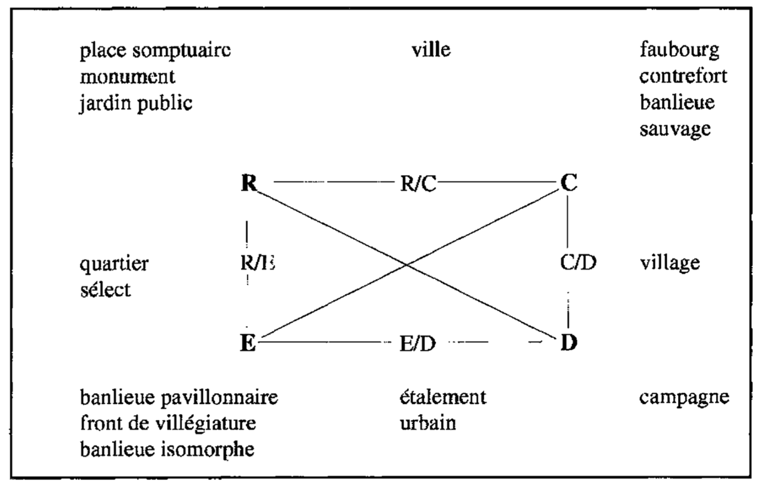
Deep spatial structuring is followed by dynamic spatial appropriation in which political control of settlement mobility intervenes. For the founders of the Chicago School, qualitative changes in spatial appropriation and occupation shaped the city. This hypothesis can be deepened by Desmarais and Ritchot's [33] concept of "political control of establishment mobility." This concept accounts not only for the movement needed to change locations, but also for the political balance of power involved. If a social actor controls his movement towards a place of establishment, his trajectory is "endoregulated." If another actor or an unfavorable context constrains his movement, his trajectory is "exoregulated." "Exoregulated" describes its trajectory. The political modality of power that controls displacements for space appropriation and occupation is not only economic, as we saw with the Chicago school's notion of competition. Controlling establishment mobility can play on other registers, such as property law.
By crossing “endoregulated” and “exoregulated” qualities with the two directions mobility trajectories can take in a city (polarizing or centripetal flows from the periphery to the center and diffusing or centrifugal flows from the center to the periphery), we identify four classes of mobility leading to as many positions in the urban space: the gathering which brings together the polarizing “endoregulated” trajectories; the dispersion which brings together the diffusing endo (Table 2).
The four classes of establishment mobility correspond to as many sequences that are articulated between them according to a cyclical dynamic: the evasion of social actors from the center who control their mobility towards the periphery conditions the subsequent gathering of other endoregulated actors in this center, which is accompanied by a rise in land and property values that forces the poorer actors who have remained ostracized to the periphery. When these trajectories meet in the city, conflicts and competitions for appropriation and occupation of positions arise, generating differentiation and complex spatial structuring over time.
4.3.2. The Structuring of Space
We have already mentioned that the three models proposed by the Chicago School for reconstructing city internal structures are based on the same hidden representation of space: an "isotropic" space with attributes that are identical in all directions. This model, however, raises two major concerns:
- They only consider centripetal and centrifugal space appropriation and occupation flows, not settlement mobility. This leads to a static conception that cannot formalize the evolution and historical transformation of specific entities.
Defined by differentiated structural positions and generated by the four classes of trajectories recognized by urban morphogenesis, an "anisotropic" representation of space is recommended. This method seems essential "to understand spatial structures." Because, to develop “an evolutionary theory, it is necessary to conceive of a relative space, which is defined by these positions and these flows” [69].
The anisotropic space model by Desmarais and Ritchot [26] reconstructs how "morphogenetic gradients" structure the space of cities in qualitatively distinct positions. High-value gradients, or "ridge lines," created by “endoregulated” flows intersect low-value depressions, or "thalweg lines." The spatial structures are an "axiological relief" of polarities. The superposition of two ridge lines locates a massif of very high value where “endoregulated” gathering is present; the crossing of two thalweg lines corresponds to a basin of very low value where “exoregulated” concentration is present; the superposition of a ridge line and a thalweg line result in a collar effect, a "threshold" of mean value where gathering, and concentration are co-present with equal intensity (Figure 11). This threshold configuration model has been used to model the growth of Paris, Rome, and Montreal.
Figure 5.
Threshold configuration. Source [51].
Figure 5.
Threshold configuration. Source [51].
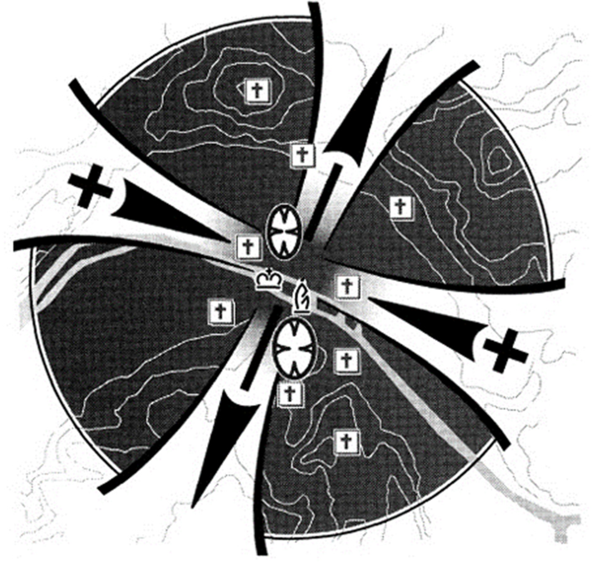
To conclude the morphogenesis school review, consider a few benchmarks for better understanding the relationship between the concrete forms that comprise urban landscapes and the hidden forms that structure them. (Figure 12) shows some examples of relationships between different neighborhood units and the structural positions generated by the trajectories:
- Monumental forms with sought-after architecture, sumptuous urban squares, temples, institutional buildings, luxury apartment towers, and large urban parks are gathering places (R).
- Working-class suburbs and neighborhoods, low-rent complexes (HLM foothills), and informal housing neighborhoods (wilderness suburbs) are concentrations (C).
- The city is organized structurally by a threshold configuration where (R/C) positions overlap. High-value buildings and low-value suburbs rub shoulders.
- The city's influence villages externalize (C/D) positions. In each, an institutional island (church, town hall, post office, etc.) stands out from craft houses, shops, and workshops.
- The countryside is typical of dispersed positions (D) dependent on the city because livestock and agriculture have low demographic densities.
- The sprawl of suburbs often far from the dense agglomeration project concrete urban forms (E/D) onto rural positions.
- Affluent suburbs as well as luxurious resort fronts materialize escapes (E).
- Bourgeois and select neighborhoods combine positions of escape and positions of assembly (R/E).
- Artisan, commercial or middle-class neighborhoods combine escape and concentration (E/C).
- Certain public squares or monumental voids materialize vacuums that give rise to gatherings followed by dispersals (R/D).
These are only a few examples among many. At this level of concrete form diversity, the conceptual tools developed by urban morphogenesis theory can be used in conjunction with those proposed by the theories of urban morphology presented in this chapter. Thus, description and explanation can complement one another and serve as guides for the urban project.
Figure 6.
The relationship between concrete forms and abstract forms. Source [33].
Figure 6.
The relationship between concrete forms and abstract forms. Source [33].
5. Conclusions
This study demonstrates the diversity of research approaches to the subject of urban morphology. Showing that descriptive and taxonomic studies are concerned with identifying and classifying the physical properties of the urban fabric. These studies focus on elements such as building types, street patterns, and public spaces and seek to understand how they contribute to the overall character of a city. For example, Italian, French, and English morphologists have developed typologies of urban form based on factors such as building height, density, and street width. Morphogenesis studies take a different approach by exploring the processes that shape urban form over time. These studies seek to uncover the hidden dimension of the urban fabric by examining how anthropological, social, and economic trends intersect to create specific spatial configurations. Morphogenesis researchers use tools such as historical analysis, ethnography, and spatial modeling to understand how cities evolve over time.
To fully understand urban morphology, it is important to use both quantitative and qualitative analysis tools in tandem. Quantitative analysis can provide valuable insights into patterns and trends in an urban form that may not be immediately apparent through qualitative observation alone. For example, GIS mapping can reveal patterns in land use or transportation networks that might not be visible on a city map. Qualitative analysis tools such as ethnography or interviews with residents can provide valuable insights into how people experience their city's physical environment. This type of research can help identify areas where improvements could be made to enhance livability or address social inequalities. Ultimately, understanding urban morphology requires recognizing that cities are constructed from a hypothesis or point of view. Different researchers may approach the study of cities from different perspectives depending on their disciplinary backgrounds or research interests.
References
- Kropf, K. The handbook of urban morphology. 2018: John Wiley & Sons.
- Sharifi, A. Urban sustainability assessment: An overview and bibliometric analysis. Ecological Indicators 2021, 121, 107102. [Google Scholar] [CrossRef]
- Jiang, B. and C. Claramunt, Integration of space syntax into GIS: new perspectives for urban morphology. Transactions in GIS 2002, 6, 295–309. [Google Scholar]
- Araújo de Oliveira, V.M. and V.M. Araújo de Oliveira, The Study of Urban Form: Different Approaches. Urban Morphology: An Introduction to the Study of the Physical Form of Cities.
- Zhu, X.X.; et al. The urban morphology on our planet–Global perspectives from space. Remote Sensing of Environment 2022, 269, 112794. [Google Scholar] [PubMed]
- Whitehand, J.W. Issues in urban morphology. Urban Morphology 2012, 16, 55–65. [Google Scholar]
- Fleischmann, M.; AFeliciotti, W. Kerr, Evolution of urban patterns: urban morphology as an open reproducible data science. Geographical Analysis 2022, 54, 536–558. [Google Scholar]
- Cerreta, M. and L. La Rocca. Urban regeneration processes and social impact: a literature review to explore the role of evaluation. in Computational Science and Its Applications–ICCSA 2021: 21st International Conference, Cagliari, Italy, September 13–16 2021, Proceedings, Part VI 21. 2021. Springer.
- Grant, M.J.; Booth, A. A typology of reviews: an analysis of 14 review types and associated methodologies. Health information & libraries journal 2009, 26, 91–108. [Google Scholar]
- Munn, Z.; et al. Systematic review or scoping review? Guidance for authors when choosing between a systematic or scoping review approach. BMC medical research methodology 2018, 18, 1–7. [Google Scholar]
- Gu, K. Urban Morphology of the Chinese City: Ases from Hainan. 2002: University of Waterloo.
- Bowen, M. Empiricism and Geographical Thought: From Francis Bacon to Alexander von Humbolt. Vol. 15. 1981: Cambridge University Press.
- Sauer, C. The morphology of landscape. Berkeley. University of California Publications in Geography 1925, 2, 296–315. [Google Scholar]
- Howard, E. Garden cities of tomorrow. 1946: Faber London, UK.
- Corbusier, L. The radiant city: Elements of a doctrine of urbanism to be used as the basis of our machine-age civilization. 1967: Orion Press.
- Wright, F.L.; et al. When democracy builds. 1945: University of Chicago Press Chicago.
- Kropf, K. The handling characteristics of urban form. Urban Design 2005, 93, 17–18. [Google Scholar]
- Whitehand, J. Urban morphology, urban landscape management and fringe belts. Urban Design 2005, 93, 19–21. [Google Scholar]
- Lynch, K. The image of the environment. The image of the city 1960, 11, 1–13. [Google Scholar]
- Jacobs, J. Jane jacobs. The Death and Life of Great American Cities 1961, 21, 13–25. [Google Scholar]
- Alexander, C. Notes on the Synthesis of Form. Vol. 5. 1964: Harvard University Press.
- Steadman, P. Architectural morphology: an introduction to the geometry of building plans. 1983: Taylor & Francis.
- Atkins, P.J. Some thoughts on temporal sampling in historical geography. Swansea Geographer 1978, 16. [Google Scholar]
- Krüger, M.J.T. An Approach to Built-Form Connectivity at an Urban Scale: Variations of Connectivity and Adjacency Measures Amongst Zones and other Related Topics. Environment and Planning B: Planning and Design 1979, 6, 305–320. [Google Scholar] [CrossRef]
- Hillier, B. and J. Hanson, The social logic of space. 1989: Cambridge university press.
- Hillier, B.; et al. Natural movement: or, configuration and attraction in urban pedestrian movement. Environment and Planning B: planning and design 199, 20, 29–66. [Google Scholar]
- Conzen, M.P. Analytical approaches to the urban landscape. Dimensions of human geography. Chicago: University of Chicago 1978, 128, 165. [Google Scholar]
- Ledrut, R. La forme et le sens dans la société. 1984: FeniXX.
- Lévy*, A. Formes urbaines et significations: revisiter la morphologie urbaine. Espaces et sociétés.
- Roncayolo, M. Lectures de villes. Formes et temps 2002.
- Park, R.E. and E.W. Burgess, Introduction to the Science of Sociology. 2019: Good Press.
- Carmona, M. and S. Tiesdell, Urban design reader. 2007: Routledge.
- Desmarais, G. and G. Ritchot, La géographie structurale. LA GÉOGRAPHIE STRUCTURALE.
- Moudon, A.V. Urban morphology as an emerging interdisciplinary field. Urban morphology 1997, 1, 3–10. [Google Scholar]
- Conzen, M.R.G. Alnwick, Northumberland: a study in town-plan analysis. Transactions and Papers (Institute of British Geographers) 1960, iii-122.
- Whitehand, J.W.R.; ISamuels, M.P. Conzen, Conzen, M.R.G. 1960: Alnwick, Northumberland: a study in town-plan analysis. Institute of British Geographers Publication 27. London: George Philip. Progress in Human Geography.
- Sadeghi, G. and B. Li, Urban Morphology: Comparative Study of Different Schools of Thought. Current Urban Studies 2019, 7, 562–572. [Google Scholar]
- Cataldai, G.; GLMaffei, P. Vaccaro, Saverio Muratori and the Italian school of planning typology. Urban morphology 2002, 6, 3–14. [Google Scholar]
- Marzot, N. The study of urban form in Italy. Urban Morphology 2002, 6, 59–73. [Google Scholar] [CrossRef]
- Rossi, A. L'architecture de la ville (1966). Paris, L'Equerre 1981.
- Rossi, A. and F. Brun, L'architecture de la ville. (No Title) 1981.
- Panerai, P.; JCastex, J.-C. Depaule, Formes urbaines: de l'îlot à la barre. 1997: Editions Parentheses.
- Merlin, P. La morphologie urbaine vue par les experts internationaux. in Morpgologie urbaine et parcellaire: colloque d’Arc-et-Senans.
- Bürgel, G. La ville aujourd'hui, Hachette, coll. Pluriel, Paris 1993.
- Joseph, I. L'école de Chicago. Naissance de l'écologie urbaine.
- Deegan, M.J. The Chicago school of ethnography. Handbook of ethnography 2001, 11–25. [Google Scholar]
- Lutters, W.G. and M.S. Ackerman, An introduction to the Chicago School of Sociology. Interval Research Proprietary 1996, 2, 1–25. [Google Scholar]
- Simmel, G.; YGrafmeyer, I. Joseph, L'école de Chicago: naissance de l'écologie urbaine. 2009: Flammarion.
- Park, R.; EBurgess, R. McKenzie, The City. Chicago: Univ. 1925, Chicago Press.
- Desmarais, G. La morphogenèse de Paris: des origines à la révolution. 1995: Editions L'Harmattan.
- Desmarais, G. Trois concepts-clés pour les modèles morphodynamiques de la ville. Cahiers de géographie du Québec.
- Desmarais*, G. La structuration morphologique de la Rome antique, du centre organisateur à la configuration de seuil. Espaces et sociétés.
- Dauphiné; A,, C.-P. Péguy, Les théories de la complexité chez les géographes. 2003.
- Prigogine, I. Irreversibility and randomness. Astrophysics and Space Science 1979, 65, 371–381. [Google Scholar] [CrossRef]
- Mandelbrot, B.B. ; Fractal geometry: what is it what does it do? Proceedings of the Royal Society of London, A. Mathematical and Physical Sciences 1989, 423, 3–16. [Google Scholar]
- Haken, H. Synergetics. Physics Bulletin 1977, 28, 412. [Google Scholar] [CrossRef]
- Reymond, H. and C. Cauvin, L'espace géographique des villes: pour une synergie multistrates. 1998: Anthropos Research & Publications.
- Boutot, A. Catastrophe theory and its critics. Synthese 1993, 96, 167–200. [Google Scholar] [CrossRef]
- Ritchot, G. Prémisses d’une théorie de la forme urbaine. Gilles RITCHOT et Claude FELTZ, Forme urbaine et pratiques sociales, Editions Le Préambule/CIACO, Montréal, Louvain-la-neuve 1985, 23-65.
- Ritchot, G. and C. Feltz, Forme urbaine et pratique sociale. 1985: Le Préambule.
- Petitot, J.; Physique du sens éditions du, C.N.R.S. 1992, Paris.
- Thom, R. Stabilité structurelle et morphogénèse: essai d'une théorie générale des modèles. Vol. 17. 1972: Addison Wesley Longman.
- Lévi-Strauss, C. Le triangle culinaire (1965). Food and History 2004, 2, 7–20. [Google Scholar] [CrossRef]
- Greimas, A.J. 1. For a Topological Semiotics, in The city and the sign. 1986, Columbia University Press. p. 25-54.
- Greimas, A. Sémantique structurale, Formes sémiologiques. 1986, Paris, PUF.
- Desmarais, G. Projection ou émergence: la structuration géographique de l’établissement bororo. Recherches Sémiotiques/Semiotic Inquiry 1992, 12, 189–215.
- Desmarais, G. and G. Ritchot, La modélisation dynamique en géographie humaine. Cahiers de géographie du Québec 1998, 42, 329–332.
- Desmarais, G. Les centres organisateurs de l’écoumène: des formes structurantes pour l’identité culturelle. Actes Sémiotiques.
- . Pumain, D. Pour une théorie évolutive des villes. L'Espace géographique 1997, 119-134.
- Pumain, D.; LSanders, T. Saint-Julien, Villes et auto-organisation. 1989: FeniXX.

Table 1.
Matrix showcasing the differences between the three schools of thought on urban morphology.
Table 1.
Matrix showcasing the differences between the three schools of thought on urban morphology.
| Intellectual School | British School | Italian School | French School |
|---|---|---|---|
| Theoretical framework | Understanding Urban Forms as Interconnected Networks | Investigating the various type of urban tissue | Observational and Perceptual Investigations |
| Main purpose | Structural systems | Typo-morphology | Island |
| Approach | Geography | Architectural | Philosophy |
| Early Pioneers | Conzen, Larkham, Whitehand | Muratori, Rossi, Aymonino, Gregotti, Caniggia | Castex, Depaule, Panerai |
Table 2.
Structural positions and trajectories. Source: Redeveloped from [33].
Table 2.
Structural positions and trajectories. Source: Redeveloped from [33].
| Directionality | Regulation | |
|---|---|---|
| - | Exoregulation | Endoregulation |
| Polarization | Gathering | Concentration |
| Diffusion | Evasion | Dispersion |
Disclaimer/Publisher’s Note: The statements, opinions and data contained in all publications are solely those of the individual author(s) and contributor(s) and not of MDPI and/or the editor(s). MDPI and/or the editor(s) disclaim responsibility for any injury to people or property resulting from any ideas, methods, instructions or products referred to in the content. |
© 2025 by the authors. Licensee MDPI, Basel, Switzerland. This article is an open access article distributed under the terms and conditions of the Creative Commons Attribution (CC BY) license (http://creativecommons.org/licenses/by/4.0/).
Copyright: This open access article is published under a Creative Commons CC BY 4.0 license, which permit the free download, distribution, and reuse, provided that the author and preprint are cited in any reuse.


