
Submitted:
03 January 2026
Posted:
06 January 2026
You are already at the latest version
Abstract
Land degradation (LD) is a dominant threat of the decade, which is deteriorating arable lands globally. Therefore, this intensification of LD has stimulated global governing bodies and researchers to take the initiative against this dilemma through sustainable and eco-friendly approaches. Geographical mapping is critical for analyzing land formation, its types, and uses; data-based maps provide a detailed overview of land use. In this study, we have created simplified SRTM-based maps for Saudi Arabia related to soil types, soil thickness, and soil uses either as vegetation or for agricultural aspects using GIS tools. Results of these GIS analyses showed that the maximum area of the country is sandy, followed by loam and sandy loam. Meanwhile, the maximum soil thickness is either under 0-4 meters or 43-50 meters. This geological display of the country could be instrumental in assessing the soil types and what sort of inputs or steps can be taken to make each type of soil fertile. Moreover, we also mentioned the land degradation pathways impacting the country’s arable lands and explained the pathways that can help assess such land losses. Besides land loss pathways, we explained the most suitable mitigation strategies, including mulching, cover cropping, agroforestry, riparian buffer strips, agroforestry, terracing, and nutrient use efficiency. In this article, we also focused on the aims of the Saudi Green Initiative and the steps that are being taken by international governing bodies like UNDP, UNEP, FAO, and the World Bank to mitigate land degradation in the region. However, further studies are required to assess the intensity of these solutions at each soil type and thickness.
Keywords:
Saudi Arabia
; geomorphology
; GIS
; land degradation
; degraded land restoration
1. Introduction
Saudi Arabia is the most developing region of the Arabian Peninsula and is the second-largest producer and exporter of oil [1]. Besides the industrial revolution, this region is also struggling with the crisis of arable land, soil fertility, and availability of water resources both for agriculture and public use [2]. Global warming, variable rainfall patterns, and frequent prevalence of drought stress are further damaging the agricultural sector of the country, where small-scale farmers or family farmers facing challenging situations of water scarcity and the rise of insect pest attacks on their crops [3,4]. Therefore, the negligence of governing bodies towards these issues may cause a significant impact on national agricultural productivity along with food and nutritional insecurity. According to FAO guidelines, 0.21 ha per person is suitable for domestic farming; however, in Saudia Arabia, this land limit is even lower than 0.010 ha per person [5]. Therefore, the agriculture sector is only contributing up to 2.71% of the gross domestic product (GDP) of Saudi Arabia [6].
Besides natural factors, certain anthropogenic activities are deteriorating soil health, for instance, deforestation, agro-chemicals, inappropriate tillage practices, overgrazing, and poor quality of irrigation water [7,8,9]. Additionally, soil degradation also occurs through the oil extraction processes where toxic chemicals and heavy metals are incorporated into the soil, which results in poor soil quality, low nutrient content, which ultimately resulted in lower crop growth and yield [9,10]. Moreover, the region’s soil is lower in organic matter, around 0.2% and anthropogenic and natural activities roughly influence it [11]. Aridisol, arenosols, and aerosols soil orders of Saudi Arabia are also the primary components of soil loss and its degradation, as these orders carry poor nutrient values and organic matter [12]. Under arid and semi-arid regions, soil sublayers usually hold a significant accumulation of gypsum, salt, and sodium, which causes soil salinity and hinders nutrient movement [13,14]Furthermore, the soil of arid regions is coarse in texture and has a low porosity rate, which decreases soil water use efficiency, water holding capacity, and water retention property [15,16].
Remote sensing and GIS are the trending and viable tools that can be used to assess geological and morphological changes in the soil and environment [17,18]. Therefore, land degradation and its sources can be easily monitored through GIS and remote sensing after extracting and modeling of relevant data [19,20]. Various studies have been conducted to examine soil health through these GIS tools; for instance (Akhavan et al., 2023) examined the soil vegetation cover of Iran and ran the produced findings on the Normalized Difference Vegetation Index (NDVI) to predict land degradation. Similarly, [19] GIS and NDVI modeling were also used to investigate global soil biological changes and land degradation patterns. Moreover, they followed NDVI and net primary production (NPP) mechanisms to observe rain use efficiency and specify which specific areas are most vulnerable to land degradation. Therefore, this study was planned to examine the characteristics of Saudi Arabian soil using systematic methodology, the latest geospatial data, and advanced GIS tools. We also explored potential threats to the country’s arable lands and how these affected lands can be recovered through sustainable approaches.
2. Geography of Saudi Arabia
Saudi Arabia is the largest country in the Arabian Peninsula, located in West Asia, and occupies a substantial portion of the northern and central regions and it shares borders with the Red Sea and the Persian Gulf. Total territory of the country is around 2.3 million km2 and a population of more than 28 million [21]. Most of the country’s land is arid, with vast stretches of desert, such as the world’s largest continuous sand desert, Rub al Khali [22]. Saudi Arabia has a diverse topography, mainly comprising large desert regions like the Arabian Desert, with semi-deserts, shrublands, and steppes scattered throughout. Its significant geological heterogeneity is further highlighted by the topography, which consists of numerous mountain ranges and vast volcanic lava fields. The Asir Mountains in the southwest and the Hijaz range near the western coast are notable mountainous areas [23]. Saudi Arabia is comprised of around 2,150,000 square kilometers, or 830,000 square miles [24], and its weather is primarily arid, with days reaching very high temperatures and nights drastically dropping. Winters are usually warm, but summer weather is significant hot, especially in the interior desert regions where temperatures frequently rise above 50 °C (122 °F) [25]. Because of their elevation, the western highlands experience a temperate temperature, contrasting with the region’s more arid environment. Cyclonic weather systems move eastward from the Mediterranean Sea throughout the winter and usually pass north of the Arabian Peninsula, occasionally causing landfall in eastern and central Arabia and the Persian Gulf.
Overall, rainfall and temperature are two of the most critical climate variables in Saudi Arabia since they affect agriculture and water replenishment. Droughts in the area have been made worse by population growth, industrial development, and greater agricultural use [26,27]. Forecasting and modeling are challenged by changes in the climate on a variety of temporal and spatial scales [28]. Saudi Arabia typically has hot, dry summers and moderate, rainy winters with a wide range of rainfall [29,30] Since the late 1990s, the Arabian Peninsula has experienced rising temperatures [31]. Numerous studies [32,33,34] have documented temperature elevation over time. Studies on rainfall show seasonal and regional variations, and predictions indicate that by 2050, there will be more extremes in both temperature and precipitation [35,36,37]. Rainfall patterns in the southwestern region, which is influenced by mountain ranges and monsoonal winds, show substantial annual variations and are necessary for understanding the future climate of Saudi Arabia [35,38,39]. Besides this, Saudi Arabia is also significantly impacted by severe flash floods and droughts, and intensity of these floods and droughts has increased substantially in recent decade [40,41].
2.1. GIS Mapping of Country’s Arable Lands
Spatial datasets including soil types, soil use, and related parameters were collected and processed separately. Variations in spatial resolution among datasets present potential accuracy concerns, representing a limitation intrinsic to regional-scale geospatial analyses. The interpretation of data was based on direct visualisation and quantitative evaluation of feature attributes, particularly spatial extent and thickness. Multi-dataset integration was conducted utilising ArcGIS software, incorporating standardised cartographic elements such as colour schemes, transparency, lighting, and shading effects to enhance visual clarity and analytical precision. The resulting maps provide a detailed spatial representation of soil types, thickness, vegetation distribution, and agricultural land use throughout Saudi Arabia, which provide evidence-based land management and planning strategies.
Data on soil types were obtained from the World Soil Database and the Harmonised World Soil Database (HWSD) via the FAO’s Soils Portal. Spatial clipping was employed to define the study area (Saudi Arabia) due to the complexity of the dataset, utilising ArcGIS. Soil mapping units were reclassified based on textural composition, specifically sand, silt, and clay content, into five categories: sand, loam, loamy sand, sandy loam, and clay. The soil type map presents a detailed spatial representation of soil distribution patterns throughout the region (Figure 1).
Meanwhile, soil thickness data were sourced from NASA’s Oak Ridge National Laboratory Distributed Active Archive Centre, with a spatial resolution of 1 km. Spatial clipping was conducted utilising the Extract by Mask tool in ArcGIS to define the study area.
Soil thickness was categorised into six distinct groups (0–50 m) to better understand the spatial variations (Figure 2). The data regarding vegetation and cultivated areas were obtained from the most recent Land Use/Land Cover (LULC) dataset. The Con tool from the Spatial Analyst toolbox was utilised to extract the target classes, which include vegetation and cultivated areas. The spatial extent was measured using the Calculate Geometry tool in ArcGIS, and this was validated through calculations in Microsoft Excel and by comparing it with Normalised Difference Vegetation Index (NDVI) values. The distinction between vegetation and cultivated areas was effectively made using colour ramp classification, resulting in a map that is both accurate and visually engaging.
2.2. Land of Saudi Arabia
A large portion of the Arabian Peninsula, around four-fifths, comprises the desert country of Saudi Arabia. It is made up of 98.5% semi-arid to arid land. Saudi Arabia’s total area is 214,969,000 ha, out of which arable land is only 3,650,000 ha; permanent crops grow on 90,000 ha; permanent pastures exist on 120,000,000 ha; forest and woodlands cover approximately 1,800,000 ha and land occupied by other things is 89,429,000 ha [42]. Saudi Arabia has 0.11 hectares of arable land per person, among the world’s lowest which means 1.6% of the country area is arable.
Figure 3.
Map showing the cultivated and natural vegetation zone of the country.
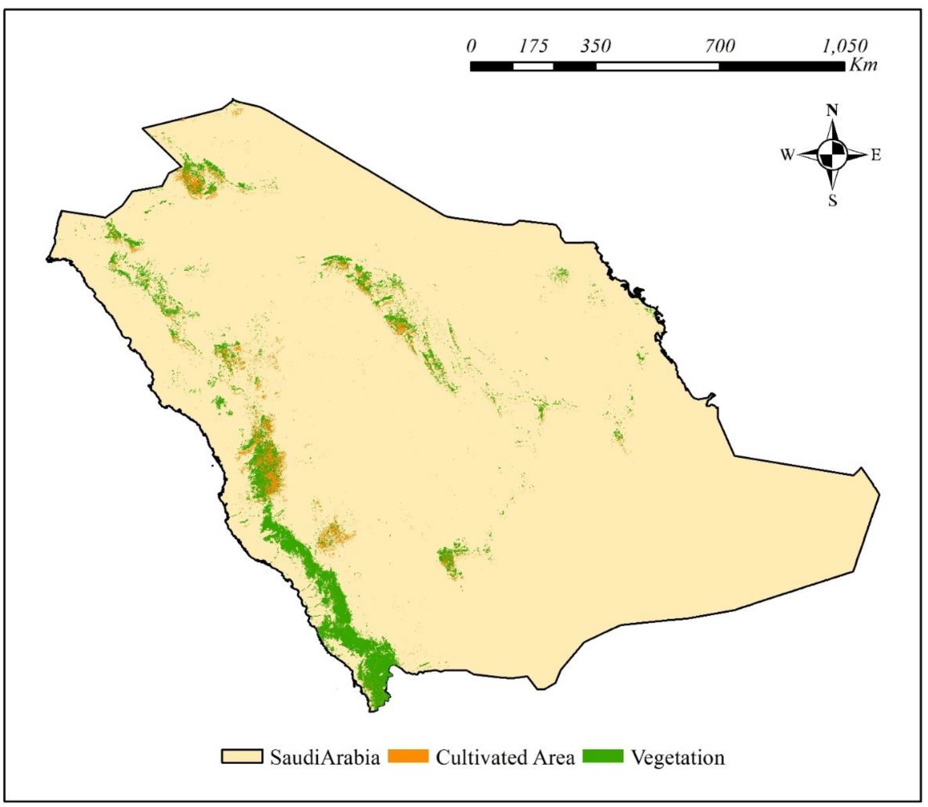
Saudi Arabia has a total of 13 provinces: Makkah (153,128 Km2), Al Bahah (9,921 Km2), Al-Qaseem (58,046 Km2), Ha’il (103,887 Km2), and Al-Jouf (100,212 Km2), Tabouk (146,072 Km2) and Al-Madina (151,990 Km2), Eastern region province (672,522 Km2), Northern Border province (111,797 Km2) and Riyad (404240 Km2), Najran (149,511 Km2) and Aseer (76.693 Km2). Saudi Arabian land is divided into cultivated areas, natural vegetation, hills/mountains, and plains. Makkah, Al Bahah Al-Qaseem, Hail, and Al-Jouf have cultivated areas; Tabuk and Al-Madina have very few cultivated areas; the Eastern region, Northern Border, and Riyad only have negligible cultivated areas meanwhile, Najran, Aseer, and Jizan contain no notable cultivated area. The area of the country covered with natural vegetation is around 54,938 Km2. Al-Jouf, Tabuk, Al-Madina, Makkah, Al Bahah, Aseer, and Jazan have more natural vegetation than other provinces; Al-Riyad, Al-Qaseem, and Hail have very little vegetation; the Eastern region and Northern Border are sparsely covered with vegetation, and Najran has no vegetation. On the other hand, hilly areas of Saudi Arabia spread over an area of 387215.88 Km2, and plain land has an area of 1548863.52 Km2. Total Area of Saudi Arabian land is 1936079.4 Km2 which is divided into five soil types: Clay Loam has an area of 72496.4 Km2 (3.74%); Loam spread over an area of 351,552 Km2 (18.16%); Loamy Sand 138,988 Km2 (7.18%); Sand 1,270,860 Km2 (65.64%); Sandy Loam 102,183 Km2 (5.28%). The most prevalent and major soil type in Saudi Arabia is sandy soil which spread in Tabuk, Makkah, Najran, Eastern region province, Riyadh, Qaseem, Hail, Northern Border, and Jawf. Sandy loam soil is mainly present in Najran but also in some areas of the Northern Border, Jizan, and Riyadh. Loamy Sand soil is present mostly in areas of Riyadh, Qaseem, Al-Madina, and Makkah. Loam soil is found in the Northern Border, Jawf, Tabuk, Al-Madina, Makkah, Aseer, Riyadh, Qaseem, and Jawf.
3. Sources of Land Loss
3.1. Aridity
A significant cause of land degradation is aridity, especially in drylands which experiences lower precipitation (less than 65% rainfall) and subsequent water deficit [43]. In practical terms, aridity is defined by a multiannual Aridity Index (precipitation divided by potential evapotranspiration) below 0.65 mm/mm, and such low moisture availability leads to poor water supply in soils and vegetation, which in turn causes land degradation [44]. Around 66.7 million km2, or 45% of the Earth’s surface area, are covered by drylands; Africa and Asia are the two most vulnerable regions where around 23 million km2 impacted in each continent [45]. Africa is more vulnerable to aridity where approximately 90% of the continent is being impacted by severe dry and warm climate. Besides Africa, it has been reported that up to 126 countries including Australia, China, the United States, Russia, Kazakhstan, Algeria, Argentina, Saudi Arabia, Sudan, India, Canada, Libya and Iran are suffering from aridity [45]. Therefore, aridity is negatively impacting up to 7.8 million km of the arable land which can cause 10% loss of agricultural GDP annually [46]. Over 2 billion people now reside in drylands, and by 2050, it is predicted that this number will be increased by 40-50%, which will further increase the severity of this issue [47]. Additionally, it has been anticipated that drylands will cover approximately 50-56% of the Earth’s land surface by 2100 due to climatic changes and greenhouse gas emissions [48]. Therefore, such enhancement in dry land will further accelerate desertification and minimize carbon sequestration capacity, which will subsequently damage global food production.
3.2. Wind Erosion
Wind erosion is a global source of land degradation which has notable environmental and socio-economic consequences [49]. This type of erosion mainly impacts dry and semi-dry areas which contain limited vegetation and faces strong winds throughout the year [50]. Therefore, it has been estimated that approximately one-third of Earth’s land area is experiencing wind erosion where inadequate agricultural management practices like deforestation, overgrazing and intensive ploughing are considered as the key drivers of wind erosion [51,52]. A series of processes occur during wind erosion that include the detachment of soil particles, their transportation via saltation, suspension, surface creep and subsequently deposition [53]. However, the vulnerability of soil to wind erosion is influenced by various factors such as wind speed, soil moisture, surface roughness, vegetation cover, soil texture, and particularly the stability or aggregation of the soil structure [54,55]. The erosion leads to the loss of fertile topsoil, which significantly contributes to land degradation and the process of desertification. Every year, approximately 2 billion tons of dust (40% of the Earth’s land surface) transported via wind erosion in which fine particulate matter, such as PM10 travel more distance compared to heavy particles [56,57]. The presence of these dust particles, which are abundant in clays and organic carbon, plays a significant role in nutrient cycling and enhances the soil’s ability to retain water and ultimately removal of such fertile soil particle impacts the soil fertility potential and subsequent plant growth. Windblown dust plays a significant role in our atmosphere which contributes to the formation of aerosols that influence climate patterns through radiative forcing [58].
3.3. Water Erosion
Water-induced soil erosion has more potential to deteriorate soil health, compared to wind erosion. Sheet, rill and gully erosion are dominant forms of water erosion which mechanically damage soil structure, water holding capacity, water infiltrate rate and subsequently soil nutrient cycling [59]. Moreover, severe erosion (>10 t ha−1 year−1) is affecting around 7% of Earth’s land surface [60], where Asia is most eroded content, as in China approximately 1.5 million km2 area is under severe threat of water erosion [61]. Similarly, other tropical regions like Bangladesh and India are facing 20-30% of land loss through erosion, however, during intensive monsoon rainfall events this land loss increased up to 50% [62,63]. Land management practices and climatic changes are considered as the main drivers of water erosion in arid and semi-arid tropical regions. Therefore, it has been reported that around 30% of the global arable land (4.3 million km2) is under severe threat of erosion which adversely impacts soil biogeochemical cycles, carbon sequestration, crop yield and global food security [64].
Saudi Arabia is predominantly impacted by wind erosion and desertification which is affecting 70% of the country’s land, however, water erosion also poses a significant threat in certain vulnerable areas [51]. In steep regions with minimal vegetation, intense rainfall can lead to significant soil erosion as in the southwestern highlands, intense rainfall can increase soil loss to 1,189 tonnes per hectare per year [65]. Eroded soil is transported into dams and other water reservoirs which results in the accumulation of sediments in water bodies. Therefore, the dams in the country have experienced a reduction of approximately 32% in their water storage capacity [66]. Overall, increasing frequency of flash floods due to climate change poses a significant risk to Saudi Arabia’s agriculture, water security, and infrastructure, highlighting the urgent need for attention to water erosion as a critical concern.
3.4. Salinization
Excessive deposition of soluble salts ions (Na+ and Ca2+) in arid and semi-arid soils cause soil salinization, which is now impacting approximately 2.6 million km2 (2%) of the arable lands [67,68]. Moreover, 50% of the salinized soil exists in Asia (China, India, Pakistan, Bangladesh and Thailand) which is deteriorating randomly 1.3 million km2 land [69]. The severity of salinization is more prominent in dry arid regions where rainfall is very limited, and evaporation rates are higher which subsequently hinder the natural process of salt leaching [70]. Over abundance of salts in soil surface not only damage plant growth (through ion toxicity and osmotic stress), but also degrade soil structure, organic matter content and soil biodiversity [71]. Therefore, it has been reported that salinized drylands are reducing agricultural crop productivity up to 43% which is causing annual loss of $27 billion in crop yield context [72].
Saudi Arabia has only 1.18 million hectares arable land (0.6% of the total area) but 40% (472000 ha) of the arable land is suffering from salinity due to improper irrigation and land management practices [73]. Besides cultivated areas, 3.6 million ha of non-cultivated areas (saline deserts and sabkhas) are also impacted by salinity [73]. Salinisation is influenced by both natural and anthropogenic activities as higher and prolonged evaporation in low lying basins encourages significant salt accumulation in soil surface [74]. Soil irrigation with salt enriched water without appropriate drainage system also regulates salt accumulation in upper layers of soil after water evaporation [75]. Besides this, changes in land use, like the removal of native vegetation, can lead to an increase in the water table, which in turn can bring subsurface salts closer to the root zone [76]. In Saudi Arabia, over-extraction of groundwater (which is often naturally salty) combined with poor drainage systems may further boost soil salinity index. Therefore, such severity of salinity in Saudi Arabia is causing crop yield loss of 38% [77].
3.5. Soil Carbon Loss
Soil organic carbon (SOC) is an essential part of soil organic matter, contributing significantly to the maintenance of soil organic matter content by improving soil structure, water retention, and facilitating nutrient cycling [78,79]. Globally, soils hold approximately 1500 Pg of carbon in their upper layers, with 750 Pg contained within the top 30 cm layer [80]. Between 2001 and 2015, nearly 2.7 million km2 of land (about 2% of the world’s surface) experienced a notable a decline in soil organic carbon in countries like Brazil, Indonesia, China, the US, and Russia [81]. The fundamental processes contributing to the decline in soil carbon content include the transformation of natural vegetation into agricultural land, deforestation in tropical and boreal forests, and urban development, which can lead to a carbon loss of 176 Pg in the topsoil (0-30 cm) [82]. Moreover, global warming further accelerates the loss of soil organic carbon by boosting microbial decomposition, particularly in carbon-rich permafrost areas [83].
In Saudi Arabia 98.5% of lands are drylands where SOC status is relatively lower compared to other countries [84]. Recent rise of land degradation in the country through desertification, overgrazing and unsustainable farming practices are further deteriorating SOC status. Moreover, hyper arid conditions of the Saudi Arabia are also crucial factor which limits the SOC stock as average topsoil of the country contain only 34 t ha−1 of SOC meanwhile other countries roughly comprised of 132 t ha−1 of SOC [85]. Besides this, anthropogenic activities such as coastal development in the Jazan region resulted in a significant loss of 4.45 million Mg C from 2009 to 2013 meanwhile, urbanisation in Abha contributed to an 11.5% reduction in vegetation cover, which further diminished the soil’s carbon storage ability [86].
3.6. Land Pollution
Land pollution is another form of land degradation that affects land quality worldwide. It results from various anthropogenic activities (mining, industrialization, and unsustainable agricultural farming) that release toxic compounds into the environment. The overabundance of various substances, including fertilizers (nitrogen, phosphorus) [87], pesticides (fungicides, insecticides, herbicides) [88], heavy metals (cadmium, mercury) [89], persistent organic pollutants (polychlorinated biphenyls, DDT) [90] radionuclides (90Sr, 137Cs) [91], electronic waste [92] petroleum products [93], and plastic [94] are considering as the major source of land pollution. Additionally, these chemicals pollute freshwater systems (lakes, rivers) worldwide [95], and makes the ecosystems more vulnerable to secondary pollution, like cyanobacteria etc [96].
In Saudi Arabia land pollution is more prominent in urban, industrial and mining areas as industrialization causes heavy metals toxicity in soil and water bodies [97]. As previous studies have reported, significant toxicity of heavy metals like Pb, Hg and As in the soils of industrial enriched cities like Jubail, Yanbu, Riyadh, Al-Ahsa [98,99]. Similarly, oil extraction and refining activities also contaminate soil through hydrocarbons meanwhile mining of gold, phosphates, and other rare earth minerals led to a significant deposition of heavy metals in surrounding soils [100,101]. Moreover, excessive use of chemical fertilizers and pesticides in agricultural fields to get higher crop yields is also notably deteriorating soil health through heavy metals pollution like As and Hg, as reported in previous research studies [102,103], although its below global threshold level. Plastic pollution is another growing concern which emerges through improper plastic waste disposal, as microplastic fragments have been reported in the Saudi soils [104,105].
3.7. Land Subsidence
Land subsidence is known as the gradual downward displacement of Earth’s surface due to compaction or the reduction of subsurface support [106]. Land subsidence is caused by both natural (tectonic movements, karst cavity collapse, permafrost melt, and sediment compaction) and anthropogenic (over extraction of groundwater and excessive mining) activities [107,108]. A recent global survey revealed that approximately 6.3 million km2 of land, or 5% of the Earth’s total land area, is experiencing significant subsidence of more than 5 mm annually [109]. Therefore, lower river deltas are more vulnerable to subsidence, and it is estimated that around 2 billion people might affect from this emerging threat [110]. In some regions, land subsidence is even worse, for instance in Chao Phraya Delta (Thailand) over pumping of groundwater drastically sinking the land up to 150 mm per year [111]. Meanwhile, excessive methane gas extraction has dropped land surface up to 5 m in past two decades in Po Delta (Italy) [112].
In Saudi Arabia, subsidence is mainly attributed to the massive extraction of fossil fuels and groundwater to meet fuel and agricultural requirement [113]. As reported in Al-Qassim region where land surface is dropping around 12 mm per year due to over extraction of fuel and groundwater [114]. Similarly, rapid expansion of urbanization and poor drainage system in Riyadh also dropping soil surface by 20 mm annually [115]. Interferometric radar also detected annual 19 mm sinking of land in Makkah which is associated with tunneling, extensive construction activities and groundwater pumping [116].
3.9. Natural Oil Extraction
The process of oil extraction is one of the primary sources of land degradation globally where approximately 30 million ha land is being contaminated through petroleum associated activities like extraction, refining, spills and leakage from petroleum products [117,118,119]. These toxic petroleum pollutants (PAHs and BTEX) accumulate in soil and deteriorate soil health which subsequently impact human health [120]. For instance, Europe has approximately 3.5 million polluted soil sites, which originates from oil industry meanwhile, China has 4.8 million ha land which is contaminated through petroleum activities [121]. Petroleum waste alters the soil pH, restrict nutrient cycling and reduce microbial activity which subsequently led towards land degradation [117,119]. Saudi Arabia is one of the world’s largest oil producers which is playing a key role in the deterioration of ecosystem. Clear evidence of chronic oil pollution has been noticed in the deserts and coastal zones of country, where petroleum contamination also elevates the salinity content in the soil layers [122]. Besides salinization, soil compaction (from heavy machinery on drill pads and roads), and erosion (from vegetation loss and disturbed, loose surfaces) are another forms of land degradation which are associated with petroleum industry [123]. Prolonged applications of such practices ultimately convert productive arable lands into waste or degraded land [124].
4. Strategies to Conserve Arable Lands and Pathways to Improve Their Fertility
4.1. Conservation Tillage and Terracing
Conservation tillage reduces soil erosion as it leaves approximately 30% of the crop residue at soil surface [125]. Water consumption efficiency and soil water storage are increased by conservation tillage techniques such as mulch tillage, ridge tillage, zero tillage (no-till), decreased tillage, and contour tillage [126,127]. Therefore, this method can be used for effective water conservation additionally, it maintains plant remains on the soil surface and a higher water content on topsoil [127]. This leads to increased water content in the soil due reduced evaporation as a result of coverage. Furthermore, this mechanism has significant benefits under arid or semi-arid conditions where plant water availability is very limited. The soil in Saudi Arabia is very coarse due to which the water runs off quickly leading to lesser water conservation. This runoff also carries away most of the soil sediments and residual agrochemicals. Under such circumstances, application of conservation tillage not only decreases the water runoff but also protects the water quality and soil health [128]. According to previous research, it has been concluded soils under the conservation tillage showed high efficiency in water usage and conservation along with the retention of macronutrient compared to the soil which were exposed to severe tillage and digging [129,130,131]. Therefore, this technique is very instrumental for the water deficient areas specifically arid or semi-arid regions. Therefore, conservation tillage is sustainable solution for the improvement of water and nutrient use efficiency as this method not only improve roots growth but also enhances crop growth and yield indexes.
Meanwhile, terracing is also another technique of soil conservation which is used to prevent soil erosion by minimizing the rainfall runoff on a sloping land [130]. Terracing has been one of the most crucial methods for reducing soil erosion, saving water, and raising agricultural yield for thousands of years [132,133]. Additionally, it is one of the first methods of soil and water conservation, is popular in hilly and mountainous areas under significant population pressure [134]. It is an ancient technique that can be used for improved water conservation and increased agricultural production. It is usually done along the curve lines on the slopes in order to make different level areas, these slopes reduces the runoff along with sufficient increase in water infiltration [135]. Terracing intercepts the rainwater which leads to increased retention of soil moisture [136]. In this way, terracing improves the water conservation, which is very essential for agricultural growth in harsh and dry regions as it reduces the volume and speed of runoff which ultimately leads to reduced soil erosion [130]. The soil erosion in semi-arid areas like Saudi Arabia is very high which results in reduced agricultural yield and loss of fertile land. Therefore, terracing can prove to be very effective in such areas by reducing soil erosion which ultimately helps to prevent nutrient loss. Dry and hilly areas of Saudi Arabia are the suitable candidate to experience terracing which will help into produce cultivable land, enhance water retention, and lessen the soil erosion.
4.2. Agroforestry and Riparian Buffer Strips
A sustainable land management approach that works well in Saudi Arabia’s climate is agroforestry as this technique offers several advantages including fuelwood, fodder, revenue, and environmental protection, entails combining trees with pastures or crops in the same field [137]. An age-old method of land management called agroforestry can greatly increase the productivity of the soil in arid areas [138]. In agroforestry systems, legume trees fix nitrogen, improving soil fertility and contributing nutrients through root decomposition and litterfall [139,140]. Agroforestry systems benefit from the windbreak function of trees, which lowers wind speed and water evaporation and increases crop yield [141]. Rehabilitating degraded land, raising land production, and protecting natural resources are the three major goals of agroforestry in dry zones. In agroforestry, woody species’ deep root systems retrieve water from lower soil levels and redistribute it to higher ones, supporting plant growth in arid conditions [142]. Agroforestry can ameliorate land degradation, reduce carbon emissions, combat pollution, and increase land vegetation cover. Additionally, higher practices of agroforestry would exceed the current global target of 17% by increasing the percentage of protected areas to almost 30% of the country’s total land area, or approximately 600,000 km2 (Brès et al., 2023b). Therefore, Agroforestry can support rural development in addition to providing fuel, firewood, fodder, and timber to rural communities and helping them diversify their sources of income. This practice can also improves soil microclimates by lowering wind speed and soil evapotranspiration, which modifies temperature and moisture content [143]. Furthermore, agroforestry systems are very successful at storing carbon in soil organic matter, harvested products, and tree biomass in addition to effectively sequestering greenhouse gases.
Another useful technique that can improve water conservation in Saudi Arabia is the establishment of riparian forest buffers. According to [144], these vegetated regions by water bodies improve farm revenue potential, improve the environment, and create habitats for wildlife. Riparian buffers are essential for managing surface runoff, urban runoff, and deep-water flow in arid and semi-arid climates meanwhile these buffers also assist reduce pollution, nutrients, and sediments [145,146]. The use of vegetative buffer strips is being pushed extensively as a successful method of shielding rivers and streams from the damaging effects of nearby land uses, such as forestry and agriculture [147]. By limiting livestock access to streams, lowering nitrogen inputs from animal excrement, and minimising streambank erosion, riparian buffers enhance the quality of water [148]. Additionally, they shield rivers and streams from the detrimental effects of nearby land uses by acting as physical barriers to sediment, fertilizers, and pesticides [149]. Riparian floodplains and associated buffer zones have a crucial ecological significance in arid and semi-arid regions. Surface runoff, wastewater and urban pollutants, deepwater flow, and infiltration processes are among the surface and subterranean water flows that they affect or lessen. Numerous environmental services, including pollution, sedimentation, and nutrient control, are accomplished by these processes. High rates of infiltration occur in riparian corridors prior to development, which postpones the ‘period of concentration,’ or the amount of time it takes for water to move from the furthest point in a watershed to the lowest spot at the outflow [150]. By preserving high infiltration rates and postponing the duration of concentration—the amount of time it takes for water to move from a watershed’s most remote point to its outlet—riparian buffers help reduce the risk of flooding in metropolitan areas like Jeddah (Blair et al., 2006). Riparian buffers are beneficial to the ecological health of water bodies because they facilitate chemical changes including denitrification and plant uptake of nutrients (Haycock and Pinay, 1993; Cooper and Gilliam, 1987).
4.3. Mulching and Cover Cropping
The world’s major water user is Agriculture sector as it consumes around 70% of the whole consumption [151]. The scarcity of water might be due to varying rainfall patterns or climate change that cause reduction in agriculture production in arid or semi-arid regions. The availability of water for agricultural producers is gradually reducing as a result of urban populations’ increasing water needs [152]. Mulching is a widespread procedure that involves spreading materials such as sand, cement, crop leftovers, plastic material, and livestock manure on the soil surface before, during, or shortly after sowing [153]. Materials used for organic mulching include animal manures, processed leftovers, wood industrial wastes, and agricultural wastes whilst inorganic mulching carries materials include polyethylene plastic sheets and synthetic polymers [153]. A number of novels environmentally friendly plastic films that are photodegradable and biodegradable, as well as surface coating and biodegradable polymer films for flexibility and simplicity of use, were also introduced. Mulching enhances soil productivity, moisture availability, and other characteristics much better than other approaches. The soil’s organic content increases swiftly when organic mulch breaks down, enhancing the soil’s capacity to retain water. Because mulches decrease evaporation, more moisture is accessible near the plant roots, extending the time for plants to absorb water as a result, mulched areas require less water [153]. Frequently mulching is believed to be beneficial to stressed environments (heat,drought, and salinity) as it changes the rate of evaporation and transpiration [153]. Mulches appear to be effective at changing water or heat balances on the soil’s surface or improving the growing environment for plants. By delaying evaporation, mulches preserve soil moisture, although their capacity to affect soil temperature varies according to the composition and optical characteristics of the mulch [153]. In general, organic mulches reduce maximum soil temperatures but boost minimum soil temperatures, whereas polyethylene mulches enhance maximum or minimum soil temperatures compared with un-mulched soil [153]. Mulch effectiveness is dependent on both the site’s climate and soil characteristics, moreover, using crop residue as mulching material can massively encourage crop growth, water conservation and soil health [154]. Since mineral mulch often withstands water vapor better than organic mulch, it is anticipated that it will save soil water more effectively. Additionally, the preservation of soil moisture was enhanced when tillage and mulching were applied combined. Because the mulch shades the soil surface from the sun, it slows down the evaporation of soil water.
Moreover, the cover crop changed the temperature of the soil and had an impact on soil evaporation [155]. It has been reported that under some conditions cover cropping had better results compared to mulching it remarkably improved soil water holding capacity by improving soil porosity, nutrient content, water infiltration and minimized land erosion. In contrast to no mulching treatment, the wheat straw mulch (5000 kg ha−1) raised the soil water content by 2.5 and 3.0% at 0–15 cm and 15–30 cm soil layers, respectively under arid region, additionally these treatments also decreased the daytime temperature by 1.9 and 1.5 °C [156]. However, it is crucial to use the right mulching materials for increasing crop yield and water use efficiency specifically under arid conditions. Global crop residue production is projected to be between 3.5 and 4.0 billion tons annually, with cereals, sugar, legumes, tubers, and oil crops accounting for 75, 10, 8, 5, and 3% of this total respectively which can be used as mulching material [157]. Similarly, Saudi Arabia produces about 400,000 tons of date palm leftovers annually based on the 20 million date palm trees that grow there and the 20 kg of dry leaves that each tree produces annually [158]. Therefore, there is an enough supply of palm wastes in Saudi Arabia that can be used for mulching.
4.4. Nutrient Management
Now a days soil degradation is the major concern in agriculture sector worldwide as a result 60% of eco system services declined where 33% loss linked with land degradation [159]. Extensive agricultural practices and climate cause forest degradation which is ultimately reduction in biodiversity. The degradation of soil/forest is caused by some biological, chemical, physical and environmental processes which subsequently degrade soil quality and fertility. Biological degradation lead towards the depletion of soil organic matter which cause declined in biodiversity and enhanced greenhouse gas emission [160]. In arid and hyper arid regions physical degradation can cause the reduction in water holding capacity and dropping the nutrient retention worldwide [13]. Therefore, a set of suitable soil indicators is chosen to address this problem, which is a challenge to perform under field conditions. In sustainable agriculture, organic matter contributes not only for soil fertility but also stimulates and moderates soil formation, biological, physiochemical properties and hydrothermal features [161,162]. Humic substances are the primary source soil organic matter and these substances enhanced the plant growth, soil water holding capacity and cation exchange capacity by modifying soils chemical, physical and biological properties to improve tilth and aeration [163,164]. All the essential nutrients which are required for plant growth and sustainable crop production is present in the soil with balanced amount and their input and output determine its fertility and nutrient use efficiency in different crop production system [165]. If the soil showed the decreasing trends of organic matter, then several important soil properties in which water infiltration rate, water holding capacity, macro porosity, soil aggregate stability and structure abundance of microbial biomass nutrient balance also depleting [166,167]. In nutrient management practices, organic compost and chemical fertilizer either alone or combination has become an effective approach. Composting is widely used practice of Saudi Arabia where about 40% of food waste, 13% cardboard, 5% paper, 6% yard waste, and 3% wood waste make up Saudi Arabia’s organic waste stream, which accounts for over 67% of the country’s municipal solid waste stream used [168]. This amounts to over 5 million tons of organic waste annually, all of which can be directed toward composting programs that will be beneficial and have a net positive impact [169]. Organic waste composting is a complicated process with many biochemical and microbiological aspects. Any changes to these parameters will likely have an impact on other parameters as well because microbial activity is dependent on oxygen levels, feedstock material particle sizes, temperature, moisture content, acidity/alkalinity, pH, and nutrient levels and balance (as indicated by carbon/nitrogen) [170]. Moreover, digested crop residue contains approximately 30% N, 30% P and 200% K which indicates that composts are the best alternative option of synthetic fertilizer to maintain soil fertility and sustainable crop production.
4.5. Land Use Planning
The term “land use” describes how people utilize and manage land and its resources in order to survive [171]. Basically, it includes use of agricultural, residential, commercial or any other anthropogenic uses but this activity is not the same as land cover, which is the term for the physical and biological elements that make up the land’s surface, whether they are created naturally or by humans [172]. Saudi Arabia soil either deep and shallow young soils over rocks as studies on the characteristics and composition of the soils in Saudi agricultural land have revealed that these areas primarily feature sand, loamy sand, and sandy loam soil texture [173].
However, acquiring accurate and precise data regarding the characterization of landforms in a timely and economical manner is crucial for comprehending land use and cover is essential for the formulation of successful policy [174]. Because of their low levels of precipitation, gulf countries are known as desert zones as water resource management, flash floods, and aridity are major problems in these areas [175]. Water resource management is challenging because of the intricate changes in hydrologic conditions that exacerbate these issues.. Pollution from urbanization and agriculture has a cumulative effect on the amount of water impacted, ultimately affecting water quality worldwide [176]. Water quality is declining due to pollutants like pesticides and fertilizers entering the water system, as well as waste from industry, sewage, and agriculture [177]. UN statistics state that all of the gulf countries aside from Oman have “acute scarcity” of water, which denotes an annual sustainable water supply of less than 500 m3 per capita [178]. Furthermore, Saudi Arabia with its thirteen provinces has the most land area and people meanwhile, country possesses the most dams 563 with a capacity of 2.6 BCM [179]. Because of the restricted amount of surface water resulting from poor rainfall and significant evaporation, Saudi Arabia is primarily dependent on its groundwater supplies and desalination [180].
5. Steps of Governing Bodies to Improve Land Conservation
To combat land desertification and improve soil fertility in Saudi Arabia, several initiatives have been taken. Global governing bodies like United Nations Development Programme (UNDP), United Nations Environment Program (UNEP), Food and Agriculture Organization (FAO) and United Nations Convention to Combat Desertification (UNCCD) are working closely with the Institutes of Saudia Arabia to minimize land loss. For instance, UNDP launched projects entitled “Capacity development for sustainable development and management of water resources in the kingdom of Saudi Arabia” [181] and “Development of policies and capacities for sustainability environment and natural resources” [182] to conserve national natural reserve through sustainable solutions. Additionally, World Bank is working remarkably for the improvement of soil health as over the past decade, the Bank provided strategic support to the ministry on various issues, including assessing the cost of rangeland degradation and desertification, as well as valuating Saudia Arabia’s mountain forests and mangrove. The findings are highly relevant for Saudi Arabia’s ambitious Vision 2030 and support the proposed large-scale reforestation and landscape restoration initiatives. Additionally, Middle East green Initiative (MGI) is another significant step to restore degraded lands, mainly in dryland countries, with a budget of at least US$2.5 billion over 10 years [183]. Moreover, the MGI is complemented by an ambitious national program, the Saudi Green Initiative (SGI), which unites environmental protection, energy transition and sustainability programs with the overarching aims of offsetting and reducing GHG emissions by increasing forest areas and support land restoration. The Saudi Arabian government’s project, known as the Saudi Green project (SGI), was introduced in 2021 with the goal of promoting climate action and outlining a plan for environmental protection both inside and beyond the Kingdom.
The project, which has high goals for the next several decades, is to conserve the environment, increase the use of clean energy, and mitigate the effects of fossil fuels in order to enhance living standards and save future generations.
By growing reliance on sustainable energy, mitigating the impact of fossil fuels, and conserving the environment, the program seeks to improve the quality of life and save future generations. Its ambitious ambitions cover the upcoming decades. In Saudi Arabia’s highlands, there are over 2.1 million hectares of woodland woods, most of which are remote, rugged, and unapproachable [184]. Additionally, 70% of these superficies whose natural rangeland area is estimated to be 1,460,000 Km2 is degraded or being affected by desertification because of overgrazing [184]. The loss of shrubs and trees, inappropriate farming practices causing surface soil instability, and ensuing erosion. Moreover, wildfires burn an average of 11,348 hectares year−1 in total which means state of rangelands has deteriorated so much in recent years [184]. In addition to these, a number of other issues, like urbanization, pollution, woodcutting, and overexploitation of freshwater resources, also play a role in the destruction of habitats.
Additionally, a key component of the SGI is planting 10 billion trees within the Kingdom over the next few decades [185]. This would equate to restoring about 40 million hectares of degraded land and represent over 4% of the Kingdom’s contribution to meeting the global target of 1 trillion trees to be planted and 1% of the initiative’s goals to limit the degradation of lands and marine habitats [185]. Additionally, replanting can lessen sandstorms, fight desertification, enhance air quality, and lower temperatures in nearby locations.
6. Conclusions
This study provides a detailed overview about the geography of Saudia Arabia where we examined the land types, thickness and use of the lands through advanced GIS tools. Moreover, potential sources of land degradation such as aridity, erosion, salinization, carbon loss, land pollution and natural oil extraction are spotted in this study. We also prioritized the best recommended solutions to mitigate land degradation, for instance the application of mulching, cover cropping, conservation tillage, nutrient management, land use management and agroforestry. Besides these recommendations, role SGI, UNDP, UNEP, FAO and world bank also summarized for the mitigation of land degradation in the study. However, further detailed studies are required to assess the role of each recommended practice under open field conditions for better understanding.
Acknowledgments
The authors would like to acknowledge the National Research and Development Center for Sustainable Agriculture (Estidamah), for providing sources of scientific information and financial support that helped to finish this research. They would also like to extend my gratitude to thank the reviewers for their valuable comments and improvements.
Conflicts of Interest
The corresponding author would like to formally declare that there is no conflict of interest related to the content of our work. I confirm that my review article has been conducted with full transparency and in accordance with ethical standards.
References
- AlGhamdi, A. Saudi Arabia energy report. King Abdullah Pet. Stud. Res. Cent 2020, 19, 1-28.
- Alotaibi, B.A.; Baig, M.B.; Najim, M.M.M.; Shah, A.A.; Alamri, Y.A. Water Scarcity Management to Ensure Food Scarcity through Sustainable Water Resources Management in Saudi Arabia. Sustainability 2023, 15, 10648. [CrossRef]
- Giordano, M.; Barron, J.; Ünver, O. Water scarcity and challenges for smallholder agriculture. In Sustainable food and agriculture; Elsevier: 2019; pp. 75-94.
- Miyan, M.A. Droughts in Asian Least Developed Countries: Vulnerability and sustainability. Weather. Clim. Extremes 2015, 7, 8–23. [CrossRef]
- Ibrahim, M.; Lal, R.; Bary, E.A.; Swelam, A. 7 Water Resources and Agronomic Productivity in the West Asia and North Africa Region. 2012.
- Ghabban, M. Econometric Insights Into Sectoral Dynamics And Economic Factors In Saudi Arabia: Assessing Impacts And Resource Utilization. Arab. J. Sci. Publ. 2024, 7, 1–17. [CrossRef]
- Bulut, S.; Gökalp, Z. Agriculture and environment interaction. Current Trends in Natural Sciences 2022, 11, 372-380.
- Kibret, K.; Abera, G.; Beyene, S. Soils and Society. In The Soils of Ethiopia; Springer: 2023; pp. 257-281.
- Shahane, A.A.; Shivay, Y.S. Soil Health and Its Improvement Through Novel Agronomic and Innovative Approaches. Front. Agron. 2021, 3. [CrossRef]
- Manzoor, M.M.; Goyal, P.; Gupta, A.P.; Gupta, S. Heavy metal soil contamination and bioremediation. Bioremediation and Biotechnology, Vol 2: Degradation of Pesticides and Heavy Metals 2020, 221-239.
- Ghandour, I.M.; Aljahdali, M.H. Elemental Enrichment in Shallow Subsurface Red Sea Coastal Sediments, Al-Shuaiba, Saudi Arabia: Natural vs. Anthropogenic Controls. Minerals 2021, 11, 898. [CrossRef]
- Al-Ghamdi, A.A.; Tadesse, Y.; Adgaba, N.; Alghamdi, A.G. Soil Degradation and Restoration in Southwestern Saudi Arabia through Investigation of Soil Physiochemical Characteristics and Nutrient Status as Indicators. Sustainability 2021, 13, 9169. [CrossRef]
- Naorem, A.; Jayaraman, S.; Dang, Y.P.; Dalal, R.C.; Sinha, N.K.; Rao, C.S.; Patra, A.K. Soil Constraints in an Arid Environment—Challenges, Prospects, and Implications. Agronomy 2023, 13, 220. [CrossRef]
- Osman, K.T.; Osman, K.T. Saline and sodic soils. Management of soil problems 2018, 255-298.
- Wang, L.; He, Z.; Zhao, W.; Wang, C.; Ma, D. Fine Soil Texture Is Conducive to Crop Productivity and Nitrogen Retention in Irrigated Cropland in a Desert-Oasis Ecotone, Northwest China. Agronomy 2022, 12, 1509. [CrossRef]
- Dlapa, P.; Hriník, D.; Hrabovský, A.; Šimkovic, I.; Žarnovičan, H.; Sekucia, F.; Kollár, J. The Impact of Land-Use on the Hierarchical Pore Size Distribution and Water Retention Properties in Loamy Soils. Water 2020, 12, 339. [CrossRef]
- Jasmin, I.; Mallikarjuna, P. Review: Satellite-based remote sensing and geographic information systems and their application in the assessment of groundwater potential, with particular reference to India. Hydrogeol. J. 2011, 19, 729–740. [CrossRef]
- Kumar, P.; Herath, S.; Avtar, R.; Takeuchi, K. Mapping of groundwater potential zones in Killinochi area, Sri Lanka, using GIS and remote sensing techniques. Sustain. Water Resour. Manag. 2016, 2, 419–430. [CrossRef]
- Reddy, G.P.O.; Kumar, N.; Singh, S.K. Remote sensing and GIS in mapping and monitoring of land degradation. Geospatial Technologies in Land Resources Mapping, Monitoring and Management 2018, 401-424.
- AbdelRahman, M.A.E. An overview of land degradation, desertification and sustainable land management using GIS and remote sensing applications. Rendiconti Lince- Sci. Fis. e Nat. 2023, 34, 767–808. [CrossRef]
- Tlili, I. Renewable energy in Saudi Arabia: current status and future potentials. Environ. Dev. Sustain. 2014, 17, 859–886. [CrossRef]
- Jafari, M.; Tavili, A.; Panahi, F.; Esfahan, E.Z.; Ghorbani, M. Reclamation of Arid Lands; Springer Nature: Durham, NC, United States, 2018; ISBN: 9783319548272.
- Saleh, N.; Elzahrany, R. Geography in Saudi Arabia. The Arab World Geographer 2009, 12, 150-172.
- Alamri, U.A.S. Energy Conservation Techniques in Mid-Rise Residential Buildings that Contribute to Mitigate Urban Heat Island in Makkah, Kingdom of Saudi Arabia. 2018.
- Abdou, A.E.A. Temperature Trend on Makkah, Saudi Arabia. Atmospheric and Climate Sciences 2014, 4, 457-481.
- Ragab, R.; Prudhomme, C. Climate change and water resources management in the southern Mediterranean and Middle East countries. In Proceedings of the The Second World Water Forum, 2000; pp. 17-22.
- Şen, Z.; Al Alsheikh, A.; Al-Turbak, A.S.; Al-Bassam, A.M.; Al-Dakheel, A.M. Climate change impact and runoff harvesting in arid regions. Arab. J. Geosci. 2011, 6, 287–295. [CrossRef]
- Lioubimtseva, E. Climate change in arid environments: revisiting the past to understand the future. Prog. Phys. Geogr. Earth Environ. 2004, 28, 502–530. [CrossRef]
- Almazroui, M. Sensitivity of a regional climate model on the simulation of high intensity rainfall events over the Arabian Peninsula and around Jeddah (Saudi Arabia). Theor. Appl. Clim. 2011, 104, 261–276. [CrossRef]
- Almazroui, M. The life cycle of extreme rainfall events over western Saudi Arabia simulated by a regional climate model: Case study of November 1996. Atmósfera 2012, 25, 23-41.
- Almazroui, M. Temperature Variability over Saudi Arabia and its Association with Global Climate Indices. JKAU Met. Env. Arid. Land. Agric. Sci 2011, 23, 85–108. [CrossRef]
- Nasrallah, H.A.; Balling, R.C. Analysis of recent climatic changes in the Arabian Peninsula region. Theor. Appl. Clim. 1996, 53, 245–252. [CrossRef]
- Elagib, N.A.; Abdu, A.S.A. Development of temperatures in the Kingdom of Bahrain from 1947 to 2005. Theor. Appl. Clim. 2009, 101, 269–279. [CrossRef]
- Rehman, S. Temperature and rainfall variation over Dhahran, Saudi Arabia, (1970–2006). Int. J. Clim. 2009, 30, 445–449. [CrossRef]
- Almazroui, M.; Islam, M.N.; Athar, H.; Jones, P.D.; Rahman, M.A. Recent climate change in the Arabian Peninsula: annual rainfall and temperature analysis of Saudi Arabia for 1978–2009. Int. J. Clim. 2012, 32, 953–966. [CrossRef]
- Almazroui, M.; Islam, M.N.; Dambul, R.; Jones, P.D. Trends of temperature extremes in Saudi Arabia. Int. J. Clim. 2013, 34, 808–826. [CrossRef]
- Kotwicki, V.; Al Sulaimani, Z. Climates of the Arabian Peninsula – past, present, future. Int. J. Clim. Chang. Strat. Manag. 2009, 1, 297–310. [CrossRef]
- Almazroui, M. Calibration of TRMM rainfall climatology over Saudi Arabia during 1998–2009. Atmospheric Res. 2011, 99, 400–414. [CrossRef]
- Furl, C.; Sharif, H.; Alzahrani, M.; El Hassan, A.; Mazari, N. Precipitation Amount and Intensity Trends Across Southwest Saudi Arabia. JAWRA J. Am. Water Resour. Assoc. 2013, 50, 74–82. [CrossRef]
- Barlow, M.; Zaitchik, B.; Paz, S.; Black, E.; Evans, J.; Hoell, A. A Review of Drought in the Middle East and Southwest Asia. J. Clim. 2016, 29, 8547–8574. [CrossRef]
- Almazroui, M.; Islam, M.N. Coupled Model Inter-comparison Project Database to Calculate Drought Indices for Saudi Arabia: A Preliminary Assessment. Earth Syst. Environ. 2019, 3, 419–428. [CrossRef]
- Amin, A.A. The extent of desertification on Saudi Arabia. Environ. Geol. 2003, -1, 1–1. [CrossRef]
- Berdugo, M.; Delgado-Baquerizo, M.; Soliveres, S.; Hernández-Clemente, R.; Zhao, Y.; Gaitán, J.J.; Gross, N.; Saiz, H.; Maire, V.; Lehmann, A.; et al. Global ecosystem thresholds driven by aridity. Science 2020, 367, 787–790. [CrossRef]
- Prăvălie, R.; Bandoc, G.; Patriche, C.; Sternberg, T. Recent changes in global drylands: Evidences from two major aridity databases. CATENA 2019, 178, 209–231. [CrossRef]
- Prăvălie, R.; Patriche, C.V.; Sîrodoev, I.; Bandoc, G.; Dumitraşcu, M.; Peptenatu, D. Water deficit and corn productivity during the post-socialist period. Case study: Southern Oltenia drylands, Romania. Arid. Land Res. Manag. 2016, 30, 239–257. [CrossRef]
- Pandit, R.; Scholes, R.; Montanarella, L.; Brainich, A.; Barger, N.; ten Brink, B.; Cantele, M.; Erasmus, B.; Fisher, J.; Gardner, T. Summary for policymakers of the assessment report on land degradation and restoration of the Intergovernmental Science-Policy Platform on Biodiversity and Ecosystem Services. 2018.
- Stavi, I.; de Pinho, J.R.; Paschalidou, A.K.; Adamo, S.B.; Galvin, K.; de Sherbinin, A.; Even, T.; Heaviside, C.; van der Geest, K. Food security among dryland pastoralists and agropastoralists: The climate, land-use change, and population dynamics nexus. Anthr. Rev. 2021, 9, 299–323. [CrossRef]
- Lal, R. Carbon Cycling in Global Drylands. Curr. Clim. Chang. Rep. 2019, 5, 221–232. [CrossRef]
- Skidmore, E. Wind erosion. In Soil erosion research methods; Routledge: 2017; pp. 265-294.
- Doetterl, S.; Berhe, A.A.; Nadeu, E.; Wang, Z.; Sommer, M.; Fiener, P. Erosion, deposition and soil carbon: A review of process-level controls, experimental tools and models to address C cycling in dynamic landscapes. Earth-Science Rev. 2016, 154, 102–122. [CrossRef]
- Alzahrani, A.J.; Alghamdi, A.G.; Ibrahim, H.M. Assessment of Soil Loss Due to Wind Erosion and Dust Deposition: Implications for Sustainable Management in Arid Regions. Appl. Sci. 2024, 14, 10822. [CrossRef]
- Nesa, M.M.; Propa, S.M.; Sen, S.; Abdullah, H.M. Land Use Change and Soil Erosion: Challenges and Way Forward to Management. In Climate Change and Soil-Water-Plant Nexus: Agriculture and Environment; Springer: 2024; pp. 547-571.
- Lackóová, L.; Pokrývková, J.; Dufková, J.K.; Policht-Latawiec, A.; Michałowska, K.; Dąbrowska, J. Long-Term Impact of Wind Erosion on the Particle Size Distribution of Soils in the Eastern Part of the European Union. Entropy 2021, 23, 935. [CrossRef]
- Tuo, D.; Lu, Q.; Wu, B.; Li, Q.; Yao, B.; Cheng, L.; Zhu, J. Effects of Wind–Water Erosion and Topographic Factor on Soil Properties in the Loess Hilly Region of China. Plants 2023, 12, 2568. [CrossRef]
- Zhang, H.; Peng, J.; Zhao, C. Wind Speed and Vegetation Coverage in Turn Dominated Wind Erosion Change With Increasing Aridity in Africa. Earth's Futur. 2024, 12. [CrossRef]
- Boloorani, A.D.; Soleimani, M.; Papi, R.; Samany, N.N.; Teymouri, P.; Soleimani, Z. Sources, drivers, and impacts of sand and dust storms: a global view. In Dust and health: Challenges and solutions; Springer: 2023; pp. 31-49.
- Opp, C.; Groll, M.; Abbasi, H.; Foroushani, M.A. Causes and Effects of Sand and Dust Storms: What Has Past Research Taught Us? A Survey. J. Risk Financial Manag. 2021, 14, 326. [CrossRef]
- Akinyoola, J.A.; Oluleye, A.; Gbode, I.E. A Review of Atmospheric Aerosol Impacts on Regional Extreme Weather and Climate Events. Aerosol Sci. Eng. 2024, 8, 249–274. [CrossRef]
- Singh, M.; Hartsch, K. Basics of soil erosion. In Watershed hydrology, management and modeling; CRC Press: 2019; pp. 1-61.
- Ma, X.; Zhao, C.; Zhu, J. Aggravated risk of soil erosion with global warming – A global meta-analysis. CATENA 2021, 200. [CrossRef]
- Li, K.; Yang, J.; Wang, J.; Wang, Z.; Zeng, Y.; Borrelli, P.; Hubacek, K.; Hu, Y.; Xu, B.; Fang, N.; et al. Human-altered soil loss dominates nearly half of water erosion in China but surges in agriculture-intensive areas. One Earth 2024, 7, 2008–2018. [CrossRef]
- Rafi, K.H.; Tasmim, N.; Islam, M.; Raju, M.R.; Karim, M.R. Unveiling the Wrath of Erosion: Assessing the Impacts of Soil Erosion on the Coastal Region of Bangladesh. Iubat Rev. 2023, 6, 1–24. [CrossRef]
- Bhattacharya, R.K.; Nilanjana, D.C.; Kousik, D. Land use and land cover change and its resultant erosion susceptible level: An appraisal using RUSLE and Logistic Regression in a tropical plateau basin of West Bengal, India. Environment, Development and Sustainability 2021, 23, 1411-1446.
- Singh, R. Impact of climate and land use land cover changes on soil erosion. In Soil and water conservation structures design; Springer: 2023; pp. 415-441.
- Alsaihani, M.; Alharbi, R. Mapping of Soil Erosion Vulnerability in Wadi Bin Abdullah, Saudi Arabia through RUSLE and Remote Sensing. Water 2024, 16, 2663. [CrossRef]
- Baig, M.B.; Alotibi, Y.; Straquadine, G.S.; Alataway, A. Water Resources in the Kingdom of Saudi Arabia: Challenges and Strategies for Improvement. In Freshwater Governance for the 21st Century; Springer: Berlin/Heidelberg, Germany, 2020; Volume 23, pp. 135–160.
- Stan, C.O.; Pîrnău, R.G.; Roșca, B.; Sirbu-Radasanu, D.S. Risk of Salinization in the Agricultural Soils of Semi-Arid Regions: A Case Study from Moldavian Plain (NE Romania). Sustainability 2022, 14, 17056. [CrossRef]
- Mashal, K.; Al-Qinna, M.; Salahat, M.; Al-Degs, Y.S.; Hamzeh, S.M. Spatial variations of urban soil salinity and related ions in arid and semiarid areas. Arab. J. Geosci. 2022, 15, 1–16. [CrossRef]
- Shahid, S.A.; Zaman, M.; Heng, L. Soil salinity: Historical perspectives and a world overview of the problem. In Guideline for salinity assessment, mitigation and adaptation using nuclear and related techniques; Springer: 2018; pp. 43-53.
- Ali, A.M.; Salem, H.M. Salinity-induced desertification in oasis ecosystems: challenges and future directions. Environ. Monit. Assess. 2024, 196, 1–20. [CrossRef]
- Ondrasek, G.; Rathod, S.; Manohara, K.K.; Gireesh, C.; Anantha, M.S.; Sakhare, A.S.; Parmar, B.; Yadav, B.K.; Bandumula, N.; Raihan, F.; et al. Salt Stress in Plants and Mitigation Approaches. Plants 2022, 11, 717. [CrossRef]
- Demo, A.H.; Gemeda, M.K.; Abdo, D.R.; Guluma, T.N.; Adugna, D.B. Impact of soil salinity, sodicity, and irrigation water salinity on crop production and coping mechanism in areas of dryland farming. Agrosystems, Geosci. Environ. 2025, 8. [CrossRef]
- Joint, F.A.O. Challenges and Opportunities for Crop Production in Dry and Saline Environments in ARASIA Member States. 2018.
- Zhang, Y.; Hou, K.; Qian, H.; Gao, Y.; Fang, Y.; Tang, S.; Xiao, S.; Ren, W.; Qu, W.; Zhang, Q. Natural-human driving factors of groundwater salinization in a long-term irrigation area. Environ. Res. 2022, 220, 115178. [CrossRef]
- Gao, L.; Yuan, Z.; Mao, X.; Ma, T. Salinity levels, trends and drivers of surface water salinization across China's river basins. Water Res. 2025, 281, 123556. [CrossRef]
- Xin, P.; Wilson, A.; Shen, C.; Ge, Z.; Moffett, K.B.; Santos, I.R.; Chen, X.; Xu, X.; Yau, Y.Y.Y.; Moore, W.; et al. Surface Water and Groundwater Interactions in Salt Marshes and Their Impact on Plant Ecology and Coastal Biogeochemistry. Rev. Geophys. 2022, 60. [CrossRef]
- Al-Kindi, K.M.; Al Dhuhli, H.S.; Al-Mezini, N.K.; Al Nadabi, M.S.; Alqasmi, D.S.; Al-Hashmi, H.S.; Ahamad, M.I.; Lu, S. Assessing Groundwater Salinization Using Spatial Machine Algorithm Techniques. Earth Syst. Environ. 2025, 1–27. [CrossRef]
- Gerke, J. The Central Role of Soil Organic Matter in Soil Fertility and Carbon Storage. Soil Syst. 2022, 6, 33. [CrossRef]
- Bashir, O.; Ali, T.; Baba, Z.A.; Rather, G.H.; Bangroo, S.A.; Mukhtar, S.D.; Naik, N.; Mohiuddin, R.; Bharati, V.; Bhat, R.A. Soil organic matter and its impact on soil properties and nutrient status. In Microbiota and biofertilizers, Vol 2: Ecofriendly tools for reclamation of degraded soil environs; Springer: 2021; pp. 129-159.
- Blakemore, R.J. Biomass Refined: 99% of Organic Carbon in Soils. Biomass 2024, 4, 1257–1300. [CrossRef]
- Zomer, R.J.; Neufeldt, H.; Xu, J.; Ahrends, A.; Bossio, D.; Trabucco, A.; van Noordwijk, M.; Wang, M. Global Tree Cover and Biomass Carbon on Agricultural Land: The contribution of agroforestry to global and national carbon budgets. Sci. Rep. 2016, 6, 29987. [CrossRef]
- Mandal, S.; Banik, G.C. Forest Degradation and its Impact on Soil Carbon. In Forest Degradation and Management: An Indian Perspective; Springer: 2025; pp. 207-225.
- Tao, J.; Liljedahl, A.K.; Burn, C.R.; Grosse, G.; Noetzli, J.; Goetz, S.J.; A Douglas, T.; Yang, Y. Permafrost vulnerability to climate change: understanding thaw dynamics and climate feedback of permafrost degradation. Environ. Res. Lett. 2025, 20, 100201. [CrossRef]
- Alharbi, S. Soil Types and Degradation Pathways in Saudi Arabia: A Geospatial Approach for Sustainable Land Management. 2025.
- Darwish, T.; Fadel, A. Mapping of soil organic carbon stock in the Arab countries to mitigate land degradation. Arab. J. Geosci. 2017, 10, 474. [CrossRef]
- Hasan, S.S.; Alharbi, O.A.; Alqurashi, A.F.; Fahil, A.S. Assessment of Desertification Dynamics in Arid Coastal Areas by Integrating Remote Sensing Data and Statistical Techniques. Sustainability 2024, 16, 4527. [CrossRef]
- Bruulsema, T. Managing nutrients to mitigate soil pollution. Environ. Pollut. 2018, 243, 1602–1605. [CrossRef]
- Tang, F.H.M.; Lenzen, M.; McBratney, A.; Maggi, F. Risk of pesticide pollution at the global scale. Nat. Geosci. 2021, 14, 206–210. [CrossRef]
- Liu, S.; Wang, X.; Guo, G.; Yan, Z. Status and environmental management of soil mercury pollution in China: A review. J. Environ. Manag. 2021, 277, 111442. [CrossRef]
- van den Berg, H. Global Status of DDT and Its Alternatives for Use in Vector Control to Prevent Disease. Environ. Health Perspect. 2009, 117, 1656–1663. [CrossRef]
- Lelieveld, J.; Kunkel, D.; Lawrence, M.G. Global risk of radioactive fallout after major nuclear reactor accidents. Atmospheric Meas. Tech. 2012, 12, 4245–4258. [CrossRef]
- Akram, R.; Natasha; Fahad, S.; Hashmi, M.Z.; Wahid, A.; Adnan, M.; Mubeen, M.; Khan, N.; Rehmani, M.I.A.; Awais, M. Trends of electronic waste pollution and its impact on the global environment and ecosystem. Environmental Science and Pollution Research 2019, 26, 16923-16938.
- Daâssi, D.; Almaghribi, F.Q. Petroleum-contaminated soil: environmental occurrence and remediation strategies. 3 Biotech 2022, 12, 1–17. [CrossRef]
- Rochman, C.M.; Hoellein, T. The global odyssey of plastic pollution. Science 2020, 368, 1184–1185. [CrossRef]
- Schwarzenbach, R.P.; Egli, T.; Hofstetter, T.B.; Von Gunten, U.V; Wehrli, B. Global Water Pollution and Human Health. Annu. Rev. Environ. Resour. 2010, 35, 109–136. [CrossRef]
- Sukenik, A.; Quesada, A.; Salmaso, N. Global expansion of toxic and non-toxic cyanobacteria: effect on ecosystem functioning. Biodivers. Conserv. 2015, 24, 889–908. [CrossRef]
- Al-Swadi, H.A.; Usman, A.R.A.; Al-Farraj, A.S.; Al-Wabel, M.I.; Ahmad, M.; Al-Faraj, A. Sources, toxicity potential, and human health risk assessment of heavy metals-laden soil and dust of urban and suburban areas as affected by industrial and mining activities. Sci. Rep. 2022, 12, 1–18. [CrossRef]
- Alnuwaiser, M.A. The analytical assessment of metal contamination in industrial soils of Saudi Arabia using the inductively coupled plasma technology. Green Process. Synth. 2024, 13. [CrossRef]
- Alghamdi, A.G.; El-Saeid, M.H.; Alzahrani, A.J.; Ibrahim, H.M. Heavy metal pollution and associated health risk assessment of urban dust in Riyadh, Saudi Arabia. PLOS ONE 2022, 17, e0261957. [CrossRef]
- Saha, L.; Bauddh, K. Characteristics of mining spoiled and oil drilling sites and adverse impacts of these activities on the environment and human health. In Phytorestoration of Abandoned Mining and Oil Drilling Sites; Elsevier: Amsterdam, The Netherlands, 2021; pp. 87–101.
- Khelifi, F.; Batool, S.; Kechiched, R.; Padoan, E.; Ncibi, K.; Hamed, Y. Abundance, distribution, and ecological/environmental risks of critical rare earth elements (REE) in phosphate ore, soil, tailings, and sediments: application of spectroscopic fingerprinting. J. Soils Sediments 2024, 24, 2099–2118. [CrossRef]
- Rashid, A.; Schutte, B.J.; Ulery, A.; Deyholos, M.K.; Sanogo, S.; Lehnhoff, E.A.; Beck, L. Heavy Metal Contamination in Agricultural Soil: Environmental Pollutants Affecting Crop Health. Agronomy 2023, 13, 1521. [CrossRef]
- Alengebawy, A.; Abdelkhalek, S.T.; Qureshi, S.R.; Wang, M.-Q. Heavy Metals and Pesticides Toxicity in Agricultural Soil and Plants: Ecological Risks and Human Health Implications. Toxics 2021, 9, 42. [CrossRef]
- Ahmad, M.; Al-Swadi, H.A.; Ahmad, J.; Akanji, M.A.; Mousa, M.A.; Lubis, N.M.; Al-Wabel, M.I.; Al-Farraj, A.S.F. Pollution and health risk assessment of co-existing microplastics and heavy metals in urban dust of Riyadh city, Saudi Arabia. Front. Environ. Sci. 2024, 12, 1377811. [CrossRef]
- Picó, Y.; Alvarez-Ruiz, R.; Alfarhan, A.H.; El-Sheikh, M.A.; Alshahrani, H.O.; Barceló, D. Pharmaceuticals, pesticides, personal care products and microplastics contamination assessment of Al-Hassa irrigation network (Saudi Arabia) and its shallow lakes. Sci. Total. Environ. 2020, 701, 135021. [CrossRef]
- Shirzaei, M.; Freymueller, J.; Törnqvist, T.E.; Galloway, D.L.; Dura, T.; Minderhoud, P.S.J. Measuring, modelling and projecting coastal land subsidence. Nat. Rev. Earth Environ. 2020, 2, 40–58. [CrossRef]
- Zerga, B. Karst topography: Formation, processes, characteristics, landforms, degradation and restoration: A systematic review. Watershed Ecol. Environ. 2024, 6, 252–269. [CrossRef]
- Veress, M. Development Environments and Factors of Subsidence Dolines. Geosciences 2021, 11, 513. [CrossRef]
- Herrera-García, G.; Ezquerro, P.; Tomás, R.; Béjar-Pizarro, M.; López-Vinielles, J.; Rossi, M.; Mateos, R.M.; Carreón-Freyre, D.; Lambert, J.; Teatini, P.; et al. Mapping the global threat of land subsidence. Science 2021, 371, 34–36. [CrossRef]
- Wu, S.; Lu, C.; Reyns, J.; Zhou, X.; Zhao, W.; Hossain, J.; Li, X.; Fang, J.; Zhang, W.; Cheng, H.; et al. Compound coastal flood exposure in global deltas: an integrated assessment of sea-level rise, subsidence, and socioeconomic dynamics. Clim. Risk Manag. 2025, 51. [CrossRef]
- Rau, J.L.; Nutalaya, P. Geomorphology and land subsidence in Bangkok, Thailand. In Applied geomorphology; Routledge: 2020; pp. 181-201.
- Corbau, C.; Simeoni, U.; Zoccarato, C.; Mantovani, G.; Teatini, P. Coupling land use evolution and subsidence in the Po Delta, Italy: Revising the past occurrence and prospecting the future management challenges. Sci. Total. Environ. 2019, 654, 1196–1208. [CrossRef]
- Adem, E.; Shults, R.; Ukasha, M.; Elfeki, A.; Alqahtani, F.; Elhag, M. Land subsidence and groundwater storage change assessment using InSAR and GRACE in the arid environment of Saudi Arabia. Nat. Hazards 2024, 120, 13137–13159. [CrossRef]
- Al-Barakah, F.N.; Aly, A.A.; Abaakhel, E.H.S.; Al-Rizkid, A.M.; Alghamdi, A.G.; Al-Sewailem, M.S. Comparison and Hydrochemical Characterization of Groundwater Resources in the Arabian Peninsula: A Case Study of Al-Baha and Al-Qassim in Saudi Arabia. Water Resour. 2020, 47, 877–891. [CrossRef]
- Aljammaz, A.; Sultan, M.; Izadi, M.; Abotalib, A.Z.; Elhebiry, M.S.; Emil, M.K.; Abdelmohsen, K.; Saleh, M.; Becker, R. Land Subsidence Induced by Rapid Urbanization in Arid Environments: A Remote Sensing-Based Investigation. Remote. Sens. 2021, 13, 1109. [CrossRef]
- Elhag, M.; Zhang, L.; Chaabani, A. Microwave data in surface deformation assessment due to anthropogenic activities in Makkah City, Saudi Arabia. Acta Geophys. 2025, 73, 5705–5717. [CrossRef]
- Mohanta, S.; Pradhan, B.; Behera, I.D. Impact and Remediation of Petroleum Hydrocarbon Pollutants on Agricultural Land: A Review. Geomicrobiol. J. 2023, 41, 345–359. [CrossRef]
- Mambwe, M.; Kalebaila, K.K.; Johnson, T. Remediation technologies for oil contaminated soil. Global J. Environ. Sci. Manage 2021, 7, 419-438.
- Mekonnen, B.A.; Aragaw, T.A.; Genet, M.B. Bioremediation of petroleum hydrocarbon contaminated soil: a review on principles, degradation mechanisms, and advancements. Front. Environ. Sci. 2024, 12, 1354422. [CrossRef]
- Majeed, B.K.; Shwan, D.M.; Rashid, K.A. A review on environmental contamination of petroleum hydrocarbons, its effects and remediation approaches. Environ. Sci. Process. Impacts 2025, 27, 526–548. [CrossRef]
- Zhang, H.; Zhao, B.; Song, Y.; Yang, Y.; Cai, L.; Miao, Q.; Jiang, T. Soil contamination in contaminated sites with key standards: A global analysis and perspective. J. Hazard. Mater. 2025, 494, 138724. [CrossRef]
- Hosseini, H.; Saadaoui, I.; Moheimani, N.; Al Saidi, M.; Al Jamali, F.; Al Jabri, H.; Ben Hamadou, R. Marine health of the Arabian Gulf: Drivers of pollution and assessment approaches focusing on desalination activities. Mar. Pollut. Bull. 2021, 164, 112085. [CrossRef]
- Alharbi, H.S. Geotechnical Controls on Land Degradation in Drylands: Indicators and Mitigation for Infrastructure and Renewable Energy. Sustainability 2025, 18, 242. [CrossRef]
- Dai, S.; Ma, Y.; Zhang, K. Land Degradation Caused by Construction Activity: Investigation, Cause and Control Measures. Int. J. Environ. Res. Public Heal. 2022, 19, 16046. [CrossRef]
- Seitz, S.; Goebes, P.; Puerta, V.L.; Pereira, E.I.; Wittwer, R.; Six, J.; Van Der Heijden, M.G.; Scholten, T. Conservation tillage and organic farming reduce soil erosion. Agron. Sustain. Dev. 2018, 39, 4. [CrossRef]
- Bekele, D. The effect of tillage on soil moisture conservation: A review. Int. J. Res. Stud. Comput 2020, 6, 30-41.
- Unger, P.W. Common soil and water conservation practices. In Soil erosion, conservation, and rehabilitation; CRC Press: 2023; pp. 239-266.
- Rodríguez, B.C.; Durán-Zuazo, V.H.; Rodríguez, M.S.; García-Tejero, I.F.; Ruiz, B.G.; Tavira, S.C. Conservation Agriculture as a Sustainable System for Soil Health: A Review. Soil Syst. 2022, 6, 87. [CrossRef]
- Rahman, M.; Alam, M.S.; Kamal, M.Z.U.; Rahman, G.K.M.M. Organic sources and tillage practices for soil management. Resources Use Efficiency in Agriculture 2020, 283-328.
- Wolka, K.; Mulder, J.; Biazin, B. Effects of soil and water conservation techniques on crop yield, runoff and soil loss in Sub-Saharan Africa: A review. Agric. Water Manag. 2018, 207, 67–79. [CrossRef]
- Sarvade, S.; Upadhyay, V.B.; Kumar, M.; Khan, M.I. Sol and water conservation techniques for sustainable agriculture. Sustainable Agriculture, Forest and Environmental Management 2019, 133-188.
- Deng, C.; Zhang, G.; Liu, Y.; Nie, X.; Li, Z.; Liu, J.; Zhu, D. Advantages and disadvantages of terracing: A comprehensive review. Int. Soil Water Conserv. Res. 2021, 9, 344–359. [CrossRef]
- Chen, D.; Wei, W.; Chen, L. Effects of terracing practices on water erosion control in China: A meta-analysis. Earth-Science Rev. 2017, 173, 109–121. [CrossRef]
- Wei, W.; Chen, D.; Wang, L.; Daryanto, S.; Chen, L.; Yu, Y.; Lu, Y.; Sun, G.; Feng, T. Global synthesis of the classifications, distributions, benefits and issues of terracing. Earth-Science Rev. 2016, 159, 388–403. [CrossRef]
- Morbidelli, R.; Saltalippi, C.; Flammini, A.; Govindaraju, R.S. Role of slope on infiltration: A review. J. Hydrol. 2018, 557, 878–886. [CrossRef]
- Wei, W.; Feng, X.; Yang, L.; Chen, L.; Feng, T.; Chen, D. The effects of terracing and vegetation on soil moisture retention in a dry hilly catchment in China. Sci. Total. Environ. 2019, 647, 1323–1332. [CrossRef]
- Dagar, J.C. Agroforestry: Four decades of research development. Indian Journal of Agroforestry 2016, 18, 1-32.
- Krishnamurthy, L.; Krishnamurthy, P.K.; Rajagopal, I.; Solares, A.P. Can agroforestry systems thrive in the drylands? Characteristics of successful agroforestry systems in the arid and semi-arid regions of Latin America. Agrofor. Syst. 2017, 93, 503–513. [CrossRef]
- Sileshi, G.W.; Mafongoya, P.L.; Nath, A.J. Agroforestry systems for improving nutrient recycling and soil fertility on degraded lands. Agroforestry for Degraded Landscapes: Recent Advances and Emerging Challenges-Vol. 1 2020, 225-253.
- Fahad, S.; Chavan, S.B.; Chichaghare, A.R.; Uthappa, A.R.; Kumar, M.; Kakade, V.; Pradhan, A.; Jinger, D.; Rawale, G.; Yadav, D.K.; et al. Agroforestry Systems for Soil Health Improvement and Maintenance. Sustainability 2022, 14, 14877. [CrossRef]
- Mume, I.D.; Workalemahu, S. Review on Windbreaks Agroforestry as a Climate Smart Agriculture Practices. Am. J. Agric. For. 2021, 9, 342. [CrossRef]
- Bayala, J.; Prieto, I. Water acquisition, sharing and redistribution by roots: applications to agroforestry systems. Plant Soil 2019, 453, 17–28. [CrossRef]
- Jacobs, S.R.; Webber, H.; Niether, W.; Grahmann, K.; Lüttschwager, D.; Schwartz, C.; Breuer, L.; Bellingrath-Kimura, S.D. Modification of the microclimate and water balance through the integration of trees into temperate cropping systems. Agric. For. Meteorol. 2022, 323. [CrossRef]
- Asbjornsen, H.; Hernandez-Santana, V.; Liebman, M.; Bayala, J.; Chen, J.; Helmers, M.; Ong, C.; Schulte, L. Targeting perennial vegetation in agricultural landscapes for enhancing ecosystem services. Renew. Agric. Food Syst. 2013, 29, 101–125. [CrossRef]
- Yan, H.; Lin, Y.; Chen, Q.; Zhang, J.; He, S.; Feng, T.; Wang, Z.; Chen, C.; Ding, J. A Review of the Eco-Environmental Impacts of the South-to-North Water Diversion: Implications for Interbasin Water Transfers. Engineering 2023, 30, 161–169. [CrossRef]
- Bogis, A.M. Ecological and Aesthetic Factors' Preferences of Urban Riparian Corridor in Arid Regions: A Visual Choice Experiment. 2021.
- Norman, A.J. The use of vegetative buffer strips to protect wetlands in southern Ontario. In Wetlands; CRC Press: 2017; pp. 263-278.
- Essien, O.E. Effectiveness of hydrologically upgraded natural vegetation riparian buffer on stream water quality protection at Uyo municipality cattle market/slaughter, Nigeria. Afr. J. Agric. Res 2012, 7, 6087-6096.
- Kroll, S.A.; Oakland, H.C. A Review of Studies Documenting the Effects of Agricultural Best Management Practices on Physiochemical and Biological Measures of Stream Ecosystem Integrity. Nat. Areas J. 2019, 39, 58–77. [CrossRef]
- Watson, J.A.; Cardenas, M.B.; Ferencz, S.B.; Knappett, P.S.; Neilson, B.T. The effects of floods on the temperature of riparian groundwater. Hydrol. Process. 2018, 32, 1267–1281. [CrossRef]
- Wakeel, M.; Chen, B.; Hayat, T.; Alsaedi, A.; Ahmad, B. Energy consumption for water use cycles in different countries: A review. Appl. Energy 2016, 178, 868–885. [CrossRef]
- McGrane, S.J. Impacts of urbanisation on hydrological and water quality dynamics, and urban water management: A review. Hydrol. Sci. J. 2016, 61, 2295–2311. [CrossRef]
- El-Beltagi, H.S.; Basit, A.; Mohamed, H.I.; Ali, I.; Ullah, S.; Kamel, E.A.R.; Shalaby, T.A.; Ramadan, K.M.A.; Alkhateeb, A.A.; Ghazzawy, H.S. Mulching as a Sustainable Water and Soil Saving Practice in Agriculture: A Review. Agronomy 2022, 12, 1881. [CrossRef]
- Ren, A.-T.; Li, J.-Y.; Zhao, L.; Zhou, R.; Ye, J.-S.; Wang, Y.-B.; Zhang, X.-C.; Wesly, K.; Ma, M.-S.; Xiong, Y.-C. Reduced plastic film mulching under zero tillage boosts water use efficiency and soil health in semiarid rainfed maize field. Resour. Conserv. Recycl. 2022, 190. [CrossRef]
- Yang, X.; Reynolds, W.; Drury, C.; Reeb Cover crop effects on soil temperature in a clay loam soil in southwestern Ontario. Can. J. Soil Sci. 2021, 101, 761–770. [CrossRef]
- El-Hendawy, S.; Alsamin, B.; Mohammed, N.; Al-Suhaibani, N.; Refay, Y.; Alotaibi, M.; Tola, E.; Mattar, M.A. Combining Planting Patterns with Mulching Bolsters the Soil Water Content, Growth, Yield, and Water Use Efficiency of Spring Wheat under Limited Water Supply in Arid Regions. Agronomy 2022, 12, 1298. [CrossRef]
- Kumar, N.; Chaudhary, A.; Ahlawat, O.; Naorem, A.; Upadhyay, G.; Chhokar, R.; Gill, S.; Khippal, A.; Tripathi, S.; Singh, G. Crop residue management challenges, opportunities and way forward for sustainable food-energy security in India: A review. Soil Tillage Res. 2023, 228. [CrossRef]
- Makkawi, Y.; Pour, F.H.; Moussa, O. Case study in arid and semi-arid regions. In Waste-to-Energy: Recent Developments and Future Perspectives towards Circular Economy; Springer: 2022; pp. 577-612.
- Bai, Z.; Dent, D.; Wu, Y.; de Jong, R. Land degradation and ecosystem services. Ecosystem services and carbon sequestration in the biosphere 2013, 357-381.
- Navarro-Pedreño, J.; Almendro-Candel, M.B.; Zorpas, A.A. The Increase of Soil Organic Matter Reduces Global Warming, Myth or Reality?. Sci 2021, 3, 18. [CrossRef]
- Lodygin, E.; Shamrikova, E.; Kubik, O.; Chebotarev, N.; Abakumov, E. The Role of Organic and Mineral Fertilization in Maintaining Fertility and Productivity of Cryolithozone Soils. Agronomy 2023, 13, 1384. [CrossRef]
- Kocsis, T.; Ringer, M.; Biró, B. Characteristics and Applications of Biochar in Soil–Plant Systems: A Short Review of Benefits and Potential Drawbacks. Appl. Sci. 2022, 12, 4051. [CrossRef]
- Gurmu, G. Soil organic matter and its role in soil health and crop productivity improvement. Forest Ecology and Management 2019, 7, 475-483.
- Ampong, K.; Thilakaranthna, M.S.; Gorim, L.Y. Understanding the Role of Humic Acids on Crop Performance and Soil Health. Front. Agron. 2022, 4. [CrossRef]
- Zhang, F.; Cui, Z.; Fan, M.; Zhang, W.; Chen, X.; Jiang, R. Integrated Soil-Crop System Management: Reducing Environmental Risk while Increasing Crop Productivity and Improving Nutrient Use Efficiency in China. J. Environ. Qual. 2011, 40, 1051–1057. [CrossRef]
- Bashir, O.; Ali, T.; Baba, Z.A.; Rather, G.H.; Bangroo, S.A.; Mukhtar, S.D.; Naik, N.; Mohiuddin, R.; Bharati, V.; Bhat, R.A. Soil organic matter and its impact on soil properties and nutrient status. Microbiota and biofertilizers, Vol 2: Ecofriendly tools for reclamation of degraded soil environs 2021, 129-159.
- Liu, M.; Han, G.; Zhang, Q. Effects of Soil Aggregate Stability on Soil Organic Carbon and Nitrogen under Land Use Change in an Erodible Region in Southwest China. Int. J. Environ. Res. Public Heal. 2019, 16, 3809. [CrossRef]
- Anjum, M.; Miandad, R.; Waqas, M.; Ahmad, I.; Alafif, Z.O.A.; Aburiazaiza, A.S.; Akhtar, T. Solid waste management in Saudi Arabia. Applied Agriculture and Biotechnology 2016, 1, 13-26.
- Farhidi, F.; Madani, K.; Crichton, R. How the US Economy and Environment can Both Benefit From Composting Management. Environ. Heal. Insights 2022, 16. [CrossRef]
- Palansooriya, K.N.; Ok, Y.S.; Awad, Y.M.; Lee, S.S.; Sung, J.-K.; Koutsospyros, A.; Moon, D.H. Impacts of biochar application on upland agriculture: A review. J. Environ. Manag. 2019, 234, 52–64. [CrossRef]
- Briassoulis, H. Analysis of land use change: theoretical and modeling approaches. 2020.
- Abd El-Kawy, O.R.; Rød, J.K.; Ismail, H.A.; Suliman, A.S. Land use and land cover change detection in the western Nile delta of Egypt using remote sensing data. Appl. Geogr. 2011, 31, 483–494. [CrossRef]
- Almalki, K.A.; Al Mosallam, M.S.; Aldaajani, T.Z.; Al-Namazi, A.A. Landforms characterization of Saudi Arabia: Towards a geomorphological map. Int. J. Appl. Earth Obs. Geoinformation 2022, 112. [CrossRef]
- Nedd, R.; Light, K.; Owens, M.; James, N.; Johnson, E.; Anandhi, A. A Synthesis of Land Use/Land Cover Studies: Definitions, Classification Systems, Meta-Studies, Challenges and Knowledge Gaps on a Global Landscape. Land 2021, 10, 994. [CrossRef]
- Saber, M.; Habib, E. Flash floods modelling for wadi system: challenges and trends. Landscape dynamics, soils and hydrological processes in varied climates 2016, 317-339.
- de Mello, K.; Taniwaki, R.H.; de Paula, F.R.; Valente, R.A.; Randhir, T.O.; Macedo, D.R.; Leal, C.G.; Rodrigues, C.B.; Hughes, R.M. Multiscale land use impacts on water quality: Assessment, planning, and future perspectives in Brazil. J. Environ. Manag. 2020, 270, 110879. [CrossRef]
- Singh, J.; Yadav, P.; Pal, A.K.; Mishra, V. Water pollutants: Origin and status. Sensors in water pollutants monitoring: Role of material 2020, 5-20.
- Amery, H.A. Arab water security: threats and opportunities in the Gulf States; Cambridge University Press: 2015.
- Salem, H.S.; Pudza, M.Y.; Yihdego, Y. Water strategies and water–food Nexus: challenges and opportunities towards sustainable development in various regions of the World. Sustain. Water Resour. Manag. 2022, 8, 1–54. [CrossRef]
- Baig, M.B.; Alotibi, Y.; Straquadine, G.S.; Alataway, A. Water Resources in the Kingdom of Saudi Arabia: Challenges and Strategies for Improvement. In Freshwater Governance for the 21st Century; Springer: Berlin/Heidelberg, Germany, 2020; Volume 23, pp. 135–160.
- UNDP. Capacity development for sustainable development and management of water resources in the kingdom of Saudi Arabia; 2024.
- UNDP. Development of policies and capacities for sustainability environment and natural resources; 2016.
- Bank, W. Fostering a sustainable future: the role of land restoration in Saudi Arabia; 2024.
- Abuzinada, A.H. First Saudi Arabian national report on the convention on biological diversity; 2020.
- SGI. Saudi Green Initiative (SGI) is an ambitious national initiative that is focused on combating climate change, improving quality of life, and protecting the environment for future generations; 2021.
Figure 1.
Soil types of Saudi Arabia as per the data of World Soil Database.
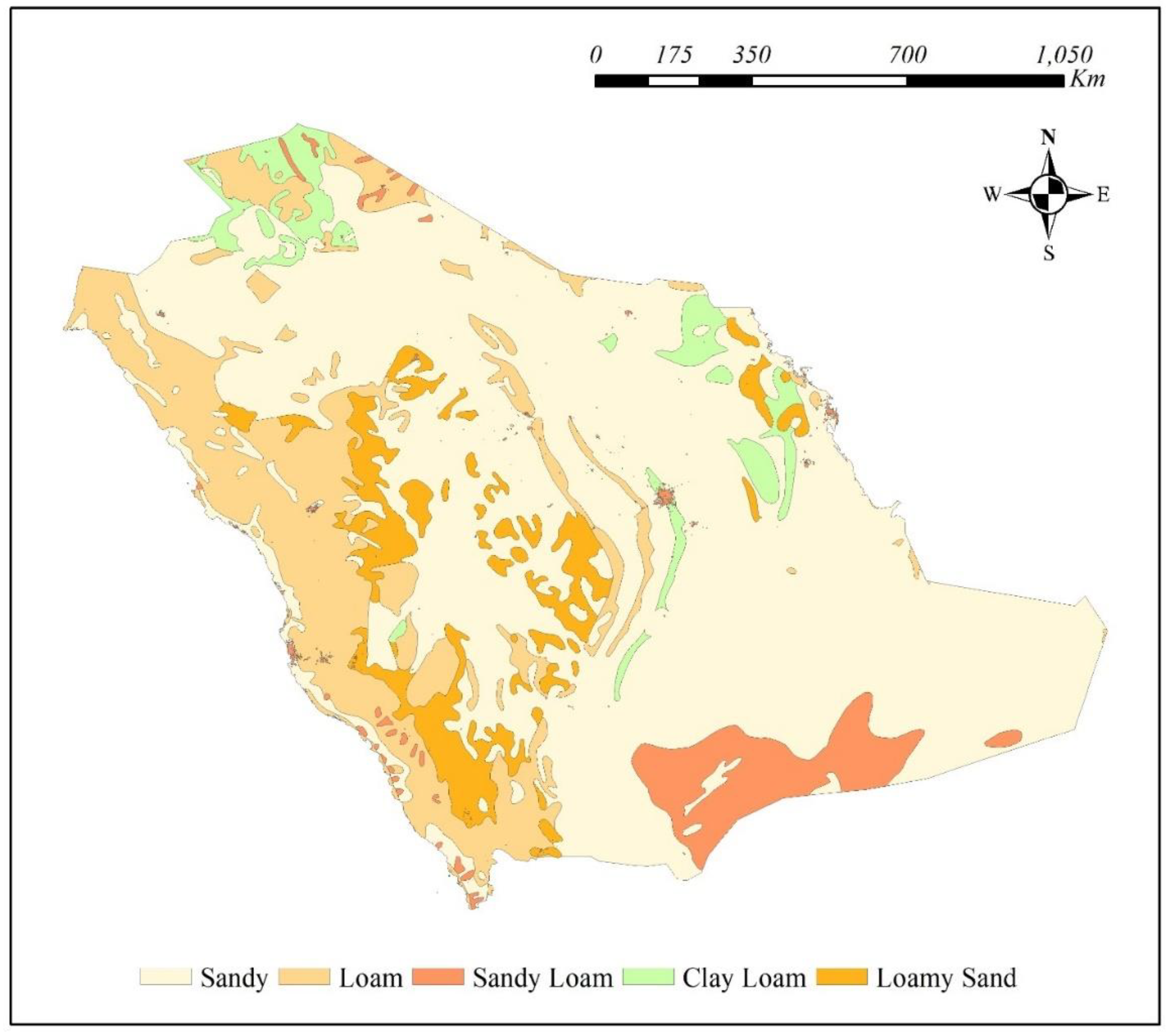
Figure 2.
A general display of soil thickness in meters.
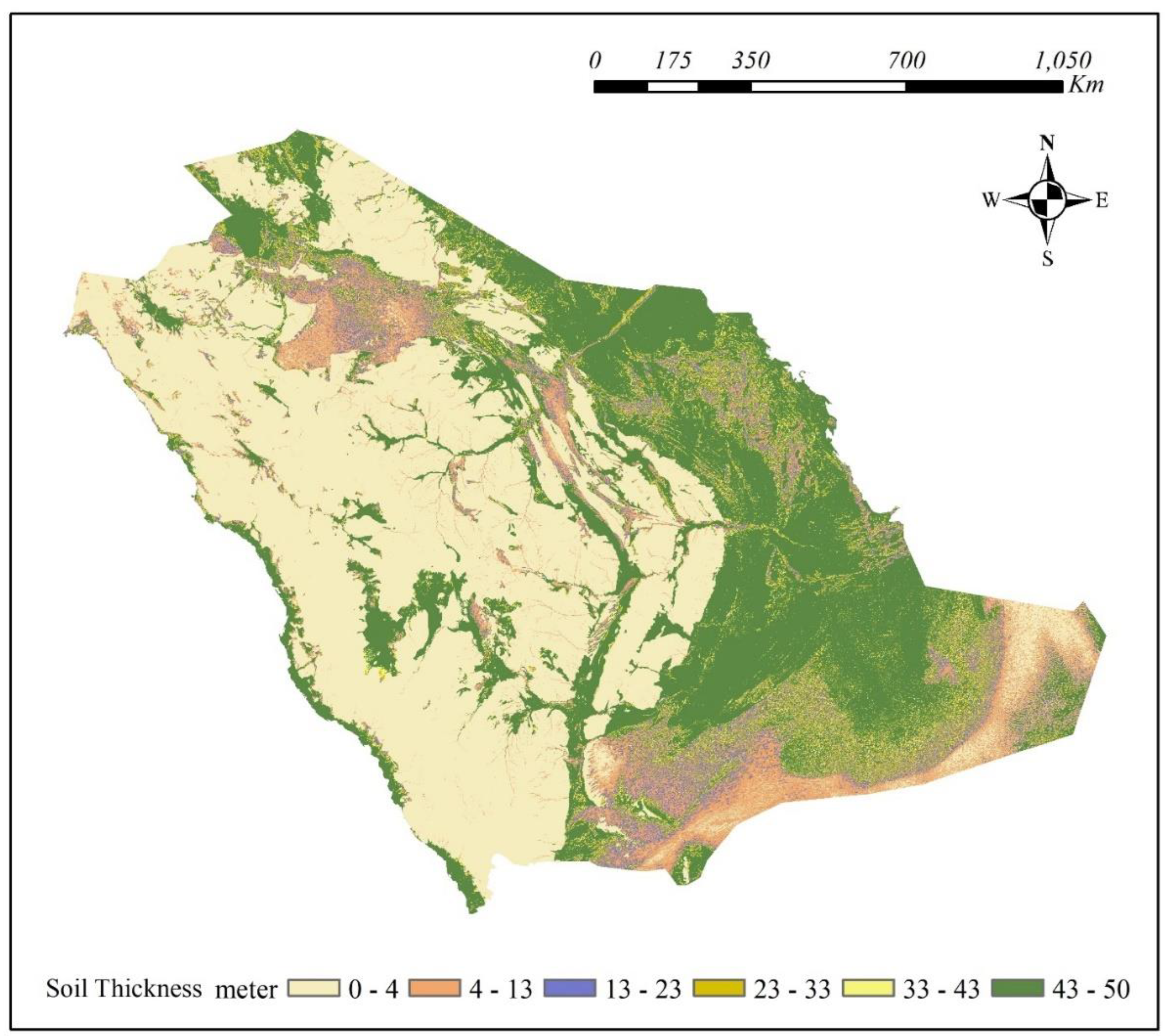
Disclaimer/Publisher’s Note: The statements, opinions and data contained in all publications are solely those of the individual author(s) and contributor(s) and not of MDPI and/or the editor(s). MDPI and/or the editor(s) disclaim responsibility for any injury to people or property resulting from any ideas, methods, instructions or products referred to in the content. |
© 2026 by the authors. Licensee MDPI, Basel, Switzerland. This article is an open access article distributed under the terms and conditions of the Creative Commons Attribution (CC BY) license.
Copyright: This open access article is published under a Creative Commons CC BY 4.0 license, which permit the free download, distribution, and reuse, provided that the author and preprint are cited in any reuse.


