
Submitted:
30 July 2025
Posted:
31 July 2025
You are already at the latest version
Abstract
Flooding poses significant risks to urban areas, especially in regions vulnerable to climate change, where developing countries are disproportionately affected. Compared to rural areas, urban zones are more severely impacted by natural disasters, particularly flooding. This study explores the influence of surface cover types on runoff and flood risk, focusing on Italian city-2 and the Rizgary neighborhood in Erbil, Kurdistan Region of Iraq. Newly developed areas are compared to older quarters to assess how different surface compositions impervious versus permeable affect hydrological responses and flood generation. The Soil Conservation Service Curve Number (SCS-CN) method was employed to model runoff under varying rainfall scenarios. The results reveal that increasing the proportion of permeable surfaces significantly reduces runoff volumes and mitigates flood risks. The study also highlights the potential of household-level rainwater harvesting and the redevelopment of low-density neighborhoods with multi-story buildings as effective strategies to reduce runoff and enhance urban resilience. These findings underscore the importance of integrating permeable materials, green infrastructure, and water harvesting measures into urban planning. The research offers valuable insights for urban planners, policymakers, and developers aiming to reduce flood risks in rapidly urbanizing areas, particularly in cities like Erbil that face the dual challenges of urban expansion and climate change.
Keywords:
Erbil
; green infrastructure
; waterharvesting
; sustainability
; urban floods
; urban planning
1. Introduction
As urban populations grow and cities expand and develop, the likelihood of natural disasters, such as floods, increases accordingly. Urban centers and residential areas are highly susceptible to flooding. Currently, individuals increasingly migrate to cities and capitals due to the availability of employment and economic opportunities. This urbanization trend is expected to intensify, with United Nations projections indicating that by 2050, 68% of the global population will reside in urban areas [1]. Urban sprawl presents significant environmental and ecological challenges, including biodiversity loss [2], increased atmospheric emissions of hazardous gases [3], and the exacerbation of heat island effects [4] and stormwater runoff [5,6]. These issues exert both direct and indirect impacts on human well-being and quality of life.
The growing threat of climate change disproportionately affects nations, particularly developing countries. These challenges extend beyond floods to include droughts, which endanger vital resources such as water for drinking, agriculture, and industry. Desertification, prevalent in certain Middle Eastern countries, has exacerbated these issues, forcing populations to migrate from regions with diminishing water resources to urban centers, as observed in southern Iraqi cities. Iraq, while contributing minimally to global pollution, is among the countries most severely impacted by climate change [7]. In the northern regions, cities such as Erbil, Sulaymaniyah, and Duhok experience frequent flooding due to intense rainfall over short periods [8,9,10]. Conversely, central and southern regions are witnessing population displacement driven by severe drought and water shortages [11,12,13]. Consequently, Iraq faces dual environmental threats: flooding in the north and drought in the central and southern areas, two opposing yet critical natural disasters.
Flood disasters in urban areas represent a significant challenge, posing recurring threats to both societal stability and individual safety. Effective flood management in urban environments is therefore a critical priority [14]. Addressing this issue necessitates the implementation of sustainable planning and development strategies to mitigate risks and enhance resilience. Rapid urbanization entails significant land use changes, where vegetative surfaces such as agricultural lands, forests, grasslands, and wetlands are transformed into developed urban areas, resulting in a growing share of impervious surfaces [15,16]. Flooding is closely linked to the expansion of impervious surfaces within urbanized landscapes, where developments and urbanization create impermeable barriers that disrupt the natural hydrological system [17]. Consequently, further research is essential to comprehend the impacts of future urbanization on surface runoff and to develop planning strategies aimed at enhancing urban resilience to flooding.
In Erbil, the rapid expansion and urban development, particularly following the 2004 liberation by coalition forces, have resulted in the extensive conversion of agricultural and undeveloped lands both within and beyond the city's municipal boundaries into built-up areas. This transformation has significantly increased impervious surfaces, thereby exacerbating surface runoff and posing challenges to effective water management [5]. An increased extent of impervious surfaces reduces infiltration while substantially elevating surface runoff volumes and peak discharge rates, thereby heightening the likelihood of urban flooding [18,19,20].
The challenges associated with surface water management are not limited to new neighborhoods but are also prevalent in many older neighborhoods of the city. Erbil's urban development spans four key periods. From 1920 to 1958, royal governance introduced regulations that disrupted the city's organic form. The republican era (1958–1991) increased urban density through socioeconomic reforms. Between 1991 and 2003, economic sanctions limited growth, resulting in informal settlements. Post-2003, master plans and investment laws spurred rapid urbanization, transforming Erbil into a thriving urban center [21]. In recent years, a concerning trend has emerged in which residents increasingly cover green areas within their properties with impermeable materials, significantly reducing water infiltration and exacerbating urban runoff issues. This phenomenon poses serious implications for the hydrological balance and urban flood risk management.
As previously indicated, the city is facing a pressing issue that has given rise to numerous critical questions. Each of these questions necessitates a well-founded scientific and practical response. Addressing this challenge requires comprehensive and rigorous scientific analysis to accurately identify and understand its underlying causes. Currently, research on urban flood modeling is categorized into three main types: hydrological models, hydrodynamic models, and simplified models [22,23]. Several key questions in this study were addressed using hydrological calculations, specifically through the application of the Soil Conservation Service Curve Number (SCS-CN) method [24]. This method was selected due to its simplicity, practicality, and minimal data requirements, making it particularly suitable for urban environments where detailed hydrological data may be limited. Its ability to provide reliable runoff estimations using readily available land use, soil type, and rainfall data made it an effective tool for evaluating surface runoff and assessing the impact of impervious and pervious surfaces on urban hydrology. The accessibility and adaptability of the SCS-CN method facilitated its implementation in this study, enabling a focused analysis of hydrological responses in a rapidly urbanizing context.
The aims of the present study were threefold: (1) to evaluate the effect of impervious surfaces associated with individual residential houses on runoff generation, highlighting the role of urban design and surface cover in shaping hydrological responses; (2) to investigate how varying spatial housing densities within residential areas influence the volume of surface runoff generated under different rainfall events, focusing on comparative analyses between Italian City 2 and Rizgary neighborhood in Erbil, Kurdistan Region of Iraq. These two neighborhoods were selected to represent distinct urban typologies, allowing for a deeper understanding of how surface characteristics and housing configurations affect urban hydrology; and (3) to assess the potential of integrating rainwater harvesting and vertical development as strategies for improving urban hydrological resilience and reducing flood risks in semi-arid regions through the application of the SCS-CN method. By integrating empirical analyses with theoretical discussions, the research aims to provide actionable insights for urban planners, policymakers, and stakeholders to address the dual challenges of rapid urbanization and climate change in semi-arid regions like Erbil.
2. Materials and Methods
2.1. Study Area
Erbil, the capital of the Kurdistan Region Iraq, is among the more rapidly developing cities in the country, attracting numerous international companies and organizations. Strategically located, Erbil shares borders with both Türkiye and Iran. The province of Erbil spans an area of 14,873.68 km², with the study areas situated within the central district of the city (Figure 1). Erbil is predominantly flat, though the northeastern and eastern regions of the province are characterized by mountainous terrain. The province experiences a semi-arid continental climate, marked by hot, dry summers and cold, wet winter. From 1980 to 2018, the mean annual precipitation in Erbil’s central district was 419.2 mm. Notably, the maximum annual rainfall recorded in 1992 reached 866.3 mm, while the minimum annual rainfall occurred in 1999, measuring 225.8 mm [10].
2.1.1. Italian City-2
The Italian city-2 neighborhood is specifically located in the northeastern part of the central district. Italian city-2 is a newly developed residential neighborhood, spanning an area of 847,402 m2. This project was undertaken by the Hemn Group of Companies, a prominent investor in urban development within the region. The neighborhood features a total of 1,561 residential units, meticulously designed to accommodate diverse housing needs. These units are available in three different sizes: Type A (200 m2), Type B (240 m2), Type C (320 m2), offering a range of options to residents (Figure 2a and 2b). It has been observed that house prices are influenced by the area, with a need to maintain a balance between the most expensive and the least expensive properties. As a result, the number of Type B houses are the highest. Although this is not the primary focus of our work, the significance and impact of this large proportion of type houses should be addressed in other sections in the light of hydrological responses.
The planning and layout of Italian city-2 have been strategically designed to optimize land use while maintaining a balance between residential spaces and essential urban infrastructure. Figure 3 illustrates the distribution of land use in Italian city-2. The chart breaks down the different categories of land use by percentage, with each segment representing a specific use of land within the neighborhood. The largest portion of the land, 50.6 %, is dedicated to residential units, highlighted in red. This is followed by roads and streets, which occupy 26.4 % of the area, shown in gray. Greenery, representing parks and open spaces, covers 12.6 % of the total area and is depicted in green. Smaller segments include pedestrian areas (7.1 %, shown in lighter gray), administration and public services (1.4 %, shown in light blue), parking lots (1.1 %, shown in orange), and mosques (0.7 %, shown in dark blue). The chart effectively visualizes the allocation of land resources in the neighborhood, emphasizing the significant portion used for residential purposes and infrastructure.
2.1.2. Rizgary Neighborhood
Rizgary neighborhood, locally known as )Kuran(, is one of the old and most established residential areas in Erbil, situated in the southwestern part of the city (Figure 4). As documented in the master’s thesis by Al-Mudaris [25], the Rizgary neighborhood was developed during the third morphological phase of Erbil’s urban growth, which occurred between 1958 and 1977. According to Almudaris, the construction of the Rizgary quarter began in the early 1960s. Her study divides the morphological evolution of Erbil into five distinct stages, with Rizgary representing a transitional period of organized, state-led urban planning characteristic of mid-20th century development. The majority of its residents are originally from surrounding rural areas, particularly the villages of Makhmur and Gwer. Covering an area of approximately 732,180 m2, Rizgary falls under the jurisdiction of the Sixth Municipality within Erbil's administrative structure. Traditionally, the standard plot size for residential units in the neighborhood was 200 m2. However, following a recent government directive, a considerable number of these plots have been subdivided into two smaller units of 100 m2 each, reflecting ongoing changes in land use and urban density within the neighborhood.
The spatial layout and urban design of Rizgary neighborhood appear to lack a structured planning approach, this reflects the urban design of that time. Upon examination, the delineation between residential areas, road networks, public service facilities, and green spaces is ambiguous, suggesting a haphazard distribution of land uses. This lack of clear zoning makes it difficult to distinguish between different urban functions. Notably, properties situated along major roads have been largely converted into commercial use, further contributing to the irregular urban fabric. Based on land use analysis, approximately 47.9 % of the neighborhood's area is occupied by residential and commercial buildings, 48.1 % by streets and roads, 1.1 % by public service structures, and only 2.9 % is allocated to green spaces (Figure 5).
2.2. Land Use Land Cover (LULC)
LULC play a critical role in determining the environmental impact of urban development, particularly in relation to water management and flood mitigation. Pervious surfaces, such as parks and green spaces, allow water to infiltrate the ground, reducing surface runoff and aiding in groundwater recharge. In contrast, impervious surfaces, such as roads, buildings, and pavements, prevent water from seeping into the soil, leading to increased surface runoff and a higher risk of flooding. In the context of urban planning, the balance between pervious and impervious surfaces plays a critical role in shaping the hydrological response of residential areas to rainfall events. Figure 6 presents a comparative analysis of pervious and impervious surface distribution in two neighborhoods: Italian city-2 and Rizgary neighborhood. In Italian city-2, impervious surfaces constitute approximately 82.5 % of the total area, while pervious surfaces such as green spaces and unpaved areas account for 17.5 %. In contrast, Rizgary neighborhood exhibits a far more critical situation, with impervious surfaces covering nearly 97.1 % of the area and pervious surfaces making up only 2.9 %. This distribution has important implications for urban runoff and flood management.
2.3. Soil Conservation Service Curve Number (SCS-CN) Methodology
The methodology employed in this study is designed to evaluate the direct runoff generated by varying proportions of pervious and impervious surfaces and to assess their influence on the hydrological response of the study area. The research was conducted through a series of systematic steps. Initially, relevant data were collected, including remote sensing imagery, rainfall datasets, and soil maps. Subsequently, the SCS-CN method was utilized to estimate the direct outflow volume. Finally, the results were analyzed and compared to draw meaningful conclusions regarding the impact of surface types on runoff generation.
United States Department of Agriculture developed one of the major methods in deriving the curve number: the SCS-CN method to calculate direct runoff volumes for given precipitation events [24]. The SCS-CN method is a widely used empirical method for estimating direct runoff (or stormwater runoff) from a rainfall event. It takes into account the land use, soil type, and antecedent moisture conditions to estimate runoff. Here’s how it can be used to calculate the runoff for a specific area, such as a house:
- Determine the Curve Number (CN):
The CN is a parameter that is determined by land use, soil type, and hydrologic conditions. CN values are derived from the SCS-CN tables, which provide standardized values for various combinations of land use and soil types. In this study, the soil group C has been selected for the Italian city-2 area and Rizgary neighborhood (Mustafa and Szydłowski, 2020). The corresponding CN values, pertinent to the hydrological soil group and land use cover, are presented in Table 1.
- Calculation of Potential Maximum Retention ():
The potential maximum retention after runoff begins is calculated using the formula:
Where is the curve number. Here, is in mm.
- Calculation of the Initial Abstraction ():
includes all losses before runoff begins, such as infiltration, evaporation, and surface storage. It is often approximated as:
- Calculation of Runoff ():
The direct runoff or excess rainfall is calculated using the equation:
Where: is the direct runoff (in mm), is the total rainfall (in mm), is the initial abstraction (in mm), is the potential maximum retention (in mm).
3. Results and Discussion
3.1. LULC Analysis by Residential Units
3.1.1. LULC Analysis of Italian City-2 by Residential Units
Houses with an area of 200 m2 are the most common in Erbil City, reflecting the preference of citizens for this particular size. The geometric layout of these plots, typically divided into dimensions of 10 m wide by 20 m long, maximizes the area available for construction (Figure 7a). The figures provide a detailed analysis of land use within such a 200 m² house in Italian city-2, emphasizing the distribution between pervious and impervious surfaces. Figure 7d highlights the overwhelming dominance of impervious surfaces, which account for 90.7 % of the total area, leaving only 9.3 % for pervious surfaces like gardens. This disproportionate allocation has significant implications for stormwater management and groundwater recharge. Figure 7g further dissects the impervious and pervious surfaces into specific categories, showing that the building area alone occupies 68.0 % of the total space, followed by the garage (10.5 %) and garden (9.3 %), with smaller portions dedicated to the courtyard, patio pathway, and walls as a fence. Together, these figures underscore the prioritization of built structures over green spaces within the residential plot, highlighting potential challenges in achieving sustainable urban development.
In recent years, 240 m2 or 250 m2 houses have become common in certain neighborhoods of Erbil City, particularly in areas developed after 2010 and in projects undertaken by investors. These houses are typically divided geometrically into plots measuring 12 m wide by 20 m long, which is considered an appropriate distribution (Figure 7b). The figures provide a detailed analysis of land use within a Type B house (240 m²) in Italian city-2. Figure 7e explains the distribution of pervious and impervious surfaces, revealing that impervious surfaces dominate the area, accounting for 88.3 % of the total space, while only 11.7 % is allocated to pervious surfaces such as gardens. Figure 7h breaks down the surface area into specific components within the Type B house. The building area occupies the majority of the space, making up 70.8 % of the total area, followed by the garden (11.7 %) and the garage (6.8 %). Smaller portions are dedicated to the courtyard, patio pathway, and walls as a fence.
The 320 m2 house type (Type C), unlike the other two types, is not very common in Erbil City due to its large size and higher cost and price. Historically, such large areas were found in certain neighborhoods of Erbil City during the 1960s and 1970s; however, since 2003, these larger plots have primarily been seen in projects developed by investors (Figure 7c). Figure 7f illustrates the distribution of pervious and impervious surfaces, revealing that impervious surfaces dominate the area, accounting for 91.2 % of the total space, while only 8.8 % is allocated to pervious surfaces such as gardens. Figure 7i breaks down the surface area into specific components within the Type C house. The building area occupies the majority of the space, comprising 63.4 % of the total area, followed by the courtyard 12.8 %, garden 8.8 %, and garage 7.5 %.
The proportion of impermeable surfaces is generally small compared to permeable surfaces in all three house types. In the case of a Type A house, it would have been more effective to increase the permeable surface area to 20 %, equating to approximately 40 square meters of the total house area. This increase in permeable surface area need not be limited to greenery; other options, such as porous roofing particularly in the garage, which occupies a significant portion of the house could have been employed. Additionally, areas like courtyards and pathways could be covered with porous materials to further reduce the amount of impervious surfaces. Moreover, as observed in Figure 7d-e-f, the distribution of permeable and impermeable surfaces is not uniform across the house types. For instance, although the Type C house has the largest total area, it possesses the smallest proportion of permeable surfaces.
3.1.2. LULC Analysis of Rizgary Neighborhood by Residential Units
Analyzing LULC in an older neighborhood such as Rizgary presents notable challenges, primarily due to limited availability of comprehensive spatial and historical data. Unlike the formally planned Italian city-2, Rizgary was developed through regulated urban planning; however, the original layout was poorly designed in terms of functionality and spatial efficiency. As a result, despite being officially planned, the neighborhood exhibits characteristics that complicate standardized assessments and sustainable urban management. The neighborhood is characterized by narrow streets ranging between 8 to 10 m wide and a high degree of informality in housing development. Most of the initial dwellings were constructed using a traditional style known as (Eastern style) [25], typically occupying plots of around 200 m² with little to no designated green space or (pervious cover).
Over time, these plots have often been subdivided into smaller units, with many now comprising two separate houses of approximately 100 m² each. To facilitate runoff estimation and urban analysis, residential and mixed-use buildings in Rizgary have been categorized into three representative types based on lot size and land use characteristics:
- Type I: Units of 100 m²
- Type II: Units of 200 m²
- Type III: Units of ≥300 m², predominantly located along main roads and currently functioning as commercial buildings with no green cover or pervious surfaces.
This classification enabled a more structured approach to runoff analysis in an otherwise highly heterogeneous and informal urban fabric.
The Figure 8a–c illustrates the distribution of impervious and pervious surfaces for three common residential house types in the Rizgary neighborhood of Erbil. Type I houses, typically 5 m wide and 20 m long (100 m²), are widespread in low-income areas due to economic constraints. These units present major environmental challenges, primarily because almost the entire plot is covered with impervious surfaces, leaving only a negligible portion for greenery or infiltration. This lack of pervious area significantly contributes to surface runoff and reduces groundwater recharge. Type II houses (200 m²) offer a slightly better condition. In newer developments, a small portion approximately 10 m² is often allocated for green or pervious surfaces, sometimes due to municipal enforcement. However, older houses of the same size often lack any pervious area, similar to Type I, and contribute to similar hydrological issues.
Type III houses (≥300 m²), typically located along main roads, have largely been converted into commercial properties. These buildings are fully impervious, with no space allocated for vegetation or infiltration. As a result, they represent the most critical environmental concern, exacerbating urban runoff and contributing to heat island effects.
3.2. Runoff Volume for Residential Units
3.2.1. Runoff Volume Estimation for Residential Units in Italian city-2
Runoff volumes from residential plots in Italian city-2 vary significantly depending on house type, rainfall probability, and storm duration. Using the SCS-Curve method, runoff (Q, in m³) was calculated for House Types A, B, and C under two design rainfall probabilities (1 % and 20 %) and storm durations of 60 and 1440 minutes [26]. Under the 60-minutes rainfall duration, the 1 % probability event generates the highest runoff, ranging from 4.98 m³ for Type A to 8.04 m³ for Type C. This reflects the increasing imperviousness from Type A to C. In contrast, the 20 % probability event yields considerably lower volumes, with Type A at 2.33 m³, Type B at 2.59 m³, and Type C at 3.79 m³ (Table 2).
During the longer 1440-minutes event, runoff volumes increase for all house types due to the higher precipitation depth. For the 1% event, Type A reaches 16.66 m³, Type B 19.62 m³, and Type C 26.77 m³. Under the 20% scenario, volumes are approximately halved, ranging from 8.66 m³ (Type A) to 13.94 m³ (Type C) (Table 2). These results demonstrate the compounded effect of impervious surface coverage and rainfall intensity on stormwater generation. Type C houses, having the largest impervious footprint, consistently produce the most runoff under all scenarios, indicating a higher contribution to surface water flow and potential flood risk.
3.2.2. Runoff Volume Estimation for Residential Units in Rizgary Neighborhood
The Table 3 presents runoff volumes (Q, in m³) generated from three residential and mixed-use building types (Type I, II, and III) within the Rizgary neighborhood under two rainfall probabilities (1 % and 20 %) and two storm durations (60 and 1440 minutes). The results clearly demonstrate that runoff volume increases with both the size and intensity of development.
For a 60-minute storm with a 1 % probability (extreme event), Type III buildings produce the highest runoff (9.00 m³), followed by Type II (5.42 m³) and Type I (2.88 m³). Under more frequent but less intense events (20 % probability), the corresponding values are reduced by approximately half, with Type III yielding 4.73 m³. For longer-duration storms (1440 minutes), runoff volumes are significantly higher due to cumulative rainfall input. Type III buildings generate 26.89 m³ at 1 % probability, compared to 17.24 m³ for Type II and 8.82 m³ for Type I. These values drop under the 20 % probability scenario but still follow the same pattern in terms of relative magnitude.
This analysis highlights the disproportionate impact of high-density and commercial land uses on stormwater generation in areas with minimal pervious surface, such as the Rizgary neighborhood, where impervious coverage exceeds 98 %. To effectively manage urban runoff and reduce flood risks, targeted green infrastructure or permeable surface interventions should be prioritized [27], especially in zones dominated by Type III structures.
3.3. Hydrological Responses of the Entire Italian City-2
To evaluate the hydrological response under different land cover conditions, rainfall events with probabilities of 1 % and 20 % were analyzed for durations of 60 and 1440 minutes [26]. The resulting surface runoff volumes (Q) reveal a significant difference between the pre-development (bare land) and post-development (urbanized) scenarios in Italian City 2.
For the 20 % probability rainfall event (Figure 9):
- After construction, the runoff volume is 7,610.69 m³.
- Before construction (bare land), the runoff was 2,511.31 m³.
For the 1 % probability rainfall event:
- After construction, runoff increases to 32,853.77 m³.
- Before construction, it was 20,864.11 m³.
These results clearly indicate that urbanization has significantly increased surface runoff, primarily due to the replacement of pervious surfaces (e.g., soil and vegetation) with impervious ones (e.g., buildings, roads, concrete). The reduced infiltration capacity and increased runoff highlight the need for integrating sustainable urban drainage and green infrastructure to mitigate hydrological impacts.
3.4. Rainwater Harvesting Potential and Runoff Reduction in Italian City-2
Rainwater harvesting (RWH) is a practical and effective strategy to reduce surface runoff, especially in urban residential areas with high impervious cover [28]. In Italian city-2, where housing units are uniformly constructed with well-angled and durable rooftops, rooftop rainwater harvesting is highly feasible. This method has been selected due to the standardized building designs and adequate roof slopes across all house types, which ensure efficient rainwater collection.
To estimate the volume of rainwater that could be harvested instead of contributing to direct runoff, we calculated the potential based on roof area, rainfall depth, and a runoff coefficient optimized for impervious rooftops (assumed as 0.9 as per similar studies [29,30,31]).
- 321 houses of 200 m² (avg. rooftop = 104 m²)
- 635 houses of 240 m² (avg. rooftop = 123 m²)
- 605 houses of 320 m² (avg. rooftop = 146 m²)
Using a design rainfall depth of 54.78 mm (P20 %, 1440-minute event), the total volume of harvestable rainwater is:
Volume = Rooftop Area × Rainfall Depth × Runoff Coefficient

Table 4.
Estimated Harvested Rainwater in Italian city-2 Based on Rooftop Area and P20% Rainfall (54.78 mm).
Table 4.
Estimated Harvested Rainwater in Italian city-2 Based on Rooftop Area and P20% Rainfall (54.78 mm).
| House Type | No. of Houses | Rooftop Area (m²) | Volume per House (m³) | Total Volume (m³) |
|---|---|---|---|---|
| Type A – 200 m² | 321 | 104 | 5.12 | 1,645 |
| Type B – 240 m² | 635 | 123 | 6.06 | 3850 |
| Type C – 320 m² | 605 | 146 | 7.19 | 4354 |
| Total | 1,561 | – | – | 9,849 m³ |
Rainwater harvesting in Italian city-2 has the potential to significantly reduce total surface runoff by capturing over 9,849 m³ of rainwater during a single P20 % (54.78 mm) storm event. This directly lowers the volume of water entering the drainage network, thereby decreasing peak flow rates and the risk of localized flooding during extreme rainfall. By diverting rooftop runoff for reuse (e.g., irrigation, cleaning), the pressure on stormwater infrastructure is alleviated. Moreover, any overflow from storage systems can be directed to pervious areas or recharge pits, contributing to shallow groundwater replenishment [32]. Collectively, this approach enhances urban resilience by mitigating flood impacts, conserving water resources, and supporting long-term aquifer sustainability.
3.5. Redevelopment Proposal for Rizgary Neighborhood Using Multi-Story Buildings
Rizgary neighborhood, located strategically near the city center of Erbil, represents one of the city's older quarters. Its proximity to key urban services and commercial zones makes it an attractive area for redevelopment and potential investment. Due to its aging infrastructure, dense horizontal housing pattern, and lack of green or recreational spaces, this neighborhood presents a significant opportunity for urban regeneration. A sustainable redesign replacing the current single-story housing units with multi-story buildings could greatly enhance land use efficiency, reduce surface runoff, and support improved quality of life for residents. Moreover, such a transformation may attract private sector investment given the neighborhood’s central location.
To address these issues, we propose a redevelopment scenario where the existing horizontal residential layout is replaced with vertical, multi-story apartment blocks. This approach aims to:
- Reduce impervious surfaces such as roofs, paved yards, and internal driveways,
- Increase pervious areas through the allocation of larger public gardens and green strips,
- Enhance neighborhood functionality by providing more space for public services such as schools, health centers, playgrounds, and parking lots,
- Widen road networks to improve accessibility and reduce congestion.
Assumptions for Simulation
- Total area of Rizgary Neighborhood: 732,180 m²
- Current land use distribution (approximate based on field survey and land use analysis):
- Type I (100 m² plots): 45 % of residential lots
- Type II (200 m² plots): 25 % of residential lots
- Type III (≥300 m² plots along main roads): 30 %
Current impervious coverage ratio: 98 % Green/pervious area: 2 %
Under the new scenario:
- Multi-story buildings (4–6 floors) will replace all existing units.
- Residential footprint will occupy only 35 % of the total area, down from 47.9 %.
- Green areas and parks will increase from 2.9% to approximately 20 %. This rate include the green and pervious surfaces in residential units, public services and roads.
- Roads will be redesigned with standard widths of 12–15 meters (30 %)
- Additional 15 % of space will be dedicated to public services and parking.
Hydrological Response Comparison: By reducing impervious surfaces and increasing vegetation and pervious areas, surface runoff during rainfall events would decrease significantly. For instance, using the SCS-CN method:
Table 5.
Estimated impervious coverage, green space potential, and runoff reduction for a redevelopment scenario in Rizgary neighborhood through replacement of single-story homes with multi-story residential buildings.
Table 5.
Estimated impervious coverage, green space potential, and runoff reduction for a redevelopment scenario in Rizgary neighborhood through replacement of single-story homes with multi-story residential buildings.
| Scenario | CN Value | Runoff (Q) at P = 20% (60 min) |
|---|---|---|
| Current Urban Fabric | 97.3 | 10,493.18 m³ |
| Redeveloped (Multi-Story) | 92 | 6069.25 m³ |
This implies a 40.15 % reduction in runoff volume, which will alleviate the local drainage burden, reduce urban flooding risk, and recharge shallow groundwater.
The multi-story redevelopment offers a more sustainable urban form by significantly reducing surface runoff and improving land use efficiency. By replacing low-rise, high-impervious structures with vertical development and integrated green infrastructure, the neighborhood can achieve better stormwater management, enhanced public space, and increased resilience. This approach aligns with global best practices in sustainable urban regeneration [32] and presents an opportunity to modernize aging city areas like Rizgary while improving environmental performance and attracting investment.
5. Conclusions
This study assessed the impact of impervious surfaces on urban flooding in two residential neighborhoods of Erbil: Italian city-2 and Rizgary neighborhood. The hydrological analysis was conducted using the SCS-CN method, which are widely adopted for urban stormwater assessments. Due to differences in spatial layout and connectivity, the runoff pathways in each neighborhood were analyzed separately. The results revealed that, despite Italian city-2 being a newly developed area, it exhibited a relatively low proportion of pervious (green) surfaces. Although this is an improvement over the older Rezgari neighborhood where impervious coverage is higher the level of green infrastructure in Italian city-2 remains suboptimal. This finding emphasizes the need for more deliberate integration of vegetation and permeable surfaces in future urban development plans to enhance resilience and sustainability. Hydrological response analysis further demonstrated that residential units in Italian city-2, particularly those with smaller plot size (Type A), performed better in terms of reducing surface runoff compared to larger houses (Type B and Type C) with limited garden space. This inverse relationship between housing area and green space is a critical concern, as increased imperviousness contributes to both urban flooding during heavy rainfall events and reduced groundwater recharge two pressing environmental issues in Erbil.
To address the adverse impacts of increased surface runoff, this study evaluated two distinct mitigation scenarios: the implementation of rooftop rainwater harvesting systems in Italian city-2, and the use of multi-story residential buildings in the densely built Rezgary neighborhood. In Italian city-2, a runoff coefficient of 0.90 was applied for typical rooftops, and the analysis demonstrated that rooftop rainwater harvesting can substantially reduce surface runoff while providing a supplementary source of non-potable water during dry periods. In contrast, the multi-story development model in Rezgary suggested that vertical expansion of housing could reduce the overall impervious footprint per household, thereby improving land use efficiency and creating space for green infrastructure. These findings highlight the critical role of integrated urban water management approaches combining architectural planning and sustainable drainage solutions in enhancing urban resilience and water security in Erbil.
Author Contributions
Conceptualization, A.M.; methodology, A.M.; software, A.M.; formal analysis, A.M.; investigation, A.M. and S.QA.; resources, A.M.; writing—original draft preparation, A.M.; writing—review and editing, S.QA., M.S. and A.M. All authors have read and agreed to the published version of the manuscript.
Funding
This research received no external funding.
Acknowledgments
The authors would like to express their sincere gratitude to the Ministry of Municipalities and Tourism in the Kurdistan Region of Iraq for their valuable support and cooperation throughout this study. Special thanks are also extended to the administration of Italian city-2 for providing access to essential data and site information, which greatly contributed to the success of this research.
Conflicts of Interest
The authors declare no conflicts of interest.
References
- Klein, T.; Anderegg, W.R.L. A vast increase in heat exposure in the 21st century is driven by global warming and urban population growth. Sustainable Cities and Society 2021, 73, 103098. [Google Scholar] [CrossRef]
- Yan, Z.; Teng, M.; He, W.; Liu, A.; Li, Y.; Wang, P. Impervious surface area is a key predictor for urban plant diversity in a city undergone rapid urbanization. Science of the Total Environment 2019, 650, 335–342. [Google Scholar] [CrossRef] [PubMed]
- Pan, H.; Page, J.; Zhang, L.; Cong, C.; Ferreira, C.; Jonsson, E.; Näsström, H.; Destouni, G.; Deal, B.; Kalantari, Z. Understanding interactions between urban development policies and GHG emissions: A case study in Stockholm Region. Ambio 2020, 49, 1313–1327. [Google Scholar] [CrossRef]
- Rahman, M.A.; Stratopoulos, L.M.; Moser-Reischl, A.; Zölch, T.; Häberle, K.-H.; Rötzer, T.; Pretzsch, H.; Pauleit, S. Traits of trees for cooling urban heat islands: A meta-analysis. Building and Environment 2020, 170, 106606. [Google Scholar] [CrossRef]
- Mustafa, A.; Szydłowski, M. The Impact of Spatiotemporal Changes in Land Development (1984–2019) on the Increase in the Runoff Coefficient in Erbil, Kurdistan Region of Iraq. Remote Sensing 2020, 12, 1302. [Google Scholar] [CrossRef]
- Gulshad, K.; Szydłowski, M.; Mustafa, A. Assessing climate change threats and urbanization impacts on surface runoff in Gdańsk (Poland): insights from remote sensing, machine learning and hydrological modeling. Stochastic Environmental Research and Risk Assessment 2024, 1–18. [Google Scholar] [CrossRef]
- Al-Ansari, N. Topography and climate of Iraq. Journal of Earth Sciences and Geotechnical Engineering 2021, 11, 1–13. [Google Scholar] [CrossRef] [PubMed]
- Al-Nassar, A.R.; Kadhim, H. Mapping flash floods in Iraq by using GIS. Environmental Sciences Proceedings 2021, 8, 39. [Google Scholar] [CrossRef]
- M Amen, A.R.; Mustafa, A.; Kareem, D.A.; Hameed, H.M.; Mirza, A.A.; Szydłowski, M.; M. Saleem, B.K. Mapping of flood-prone areas utilizing GIS techniques and remote sensing: a case study of Duhok, Kurdistan Region of Iraq. Remote Sensing 2023, 15, 1102. [Google Scholar] [CrossRef]
- Mustafa, A.M.; Muhammed, H.H.; Szydlowski, M. EXTREME RAINFALLS AS A CAUSE OF URBAN FLASH FLOODS; A CASE STUDY OF THE ERBIL-KURDISTAN REGION OF IRAQ. Acta Scientiarum Polonorum. Formatio Circumiectus 2019, 18, 113–132. [Google Scholar] [CrossRef]
- Adamo, N.; Al-Ansari, N.; Sissakian, V.; Fahmi, K.J.; Abed, S.A. Climate change: Droughts and increasing desertification in the Middle East, with special reference to Iraq. Engineering 2022, 14, 235–273. [Google Scholar] [CrossRef]
- Al-Muhyi, A.H.A.; Aleedani, F.Y.K. Impacts of global climate change on temperature and precipitation in basra city, iraq. Basrah Journal of Sciences 2022, 40, 215–230. [Google Scholar] [CrossRef]
- Ethaib, S.; Zubaidi, S.L.; Al-Ansari, N. Evaluation water scarcity based on GIS estimation and climate-change effects: A case study of Thi-Qar Governorate, Iraq. Cogent Engineering 2022, 9, 2075301. [Google Scholar] [CrossRef]
- Xu, T.; Xie, Z.; Zhao, F.; Li, Y.; Yang, S.; Zhang, Y.; Yin, S.; Chen, S.; Li, X.; Zhao, S. Permeability control and flood risk assessment of urban underlying surface: a case study of Runcheng south area, Kunming. Natural Hazards 2022, 1–26. [Google Scholar] [CrossRef]
- Kim, H.W.; Kim, J.-H.; Li, W.; Yang, P.; Cao, Y. Exploring the impact of green space health on runoff reduction using NDVI. Urban Forestry & Urban Greening 2017, 28, 81–87. [Google Scholar] [CrossRef]
- Li, C.; Liu, M.; Hu, Y.; Shi, T.; Qu, X.; Walter, M.T. Effects of urbanization on direct runoff characteristics in urban functional zones. Science of the Total Environment 2018, 643, 301–311. [Google Scholar] [CrossRef]
- Sjöman, J.D.; Gill, S.E. Residential runoff–The role of spatial density and surface cover, with a case study in the Höjeå river catchment, southern Sweden. Urban forestry & urban greening 2014, 13, 304–314. [Google Scholar]
- Li, F.; Liu, Y.; Engel, B.A.; Chen, J.; Sun, H. Green infrastructure practices simulation of the impacts of land use on surface runoff: Case study in Ecorse River watershed, Michigan. Journal of Environmental Management 2019, 233, 603–611. [Google Scholar] [CrossRef]
- Schoener, G. Urban Runoff in the U.S. Southwest: Importance of Impervious Surfaces for Small-Storm Hydrology. Journal of Hydrologic Engineering 2018, 23, 05017033. [Google Scholar] [CrossRef]
- Yao, L.; Chen, L.; Wei, W. Exploring the Linkage between Urban Flood Risk and Spatial Patterns in Small Urbanized Catchments of Beijing, China. International Journal of Environmental Research and Public Health 2017, 14, 239. [Google Scholar] [CrossRef]
- Sabr, C. A study on the urban form of Erbil city (the capital of Kurdistan region) as an example of historical and fast growing city. Humanities and Social Sciences Review, CD-ROM 2014, 3, 325–340. [Google Scholar]
- Qi, W.; Ma, C.; Xu, H.; Chen, Z.; Zhao, K.; Han, H. A review on applications of urban flood models in flood mitigation strategies. Natural Hazards 2021, 108, 31–62. [Google Scholar] [CrossRef]
- Xia Jun, X.J.; Zhang Yin, Z.Y.; Liang ChangMei, L.C.; Liu Jie, L.J. Review on urban storm water models. 2018.
- NRCS, U. National engineering handbook: Part 630—hydrology. USDA Soil Conservation Service: Washington, DC, USA.
- Al-Mudaris, S.B. The Residential Pattern In Arbil City (An Analytical Study In Urban Geography). Salahaddin University-Erbil, 2003.
- Kareem, D.A.; M Amen, A.R.; Mustafa, A.; Yüce, M.I.; Szydłowski, M. Comparative Analysis of Developed Rainfall Intensity–Duration–Frequency Curves for Erbil with Other Iraqi Urban Areas. Water 2022, 14, 419. [Google Scholar] [CrossRef]
- Aziz, S.Q.; Saleh, S.M.; Muhammad, S.H.; Ismael, S.O.; Ahmed, B.M. Flood Disaster in Erbil City: Problems and Solutions. Environmental Protection Research 2023, 303–318. [Google Scholar] [CrossRef]
- Ahmed, H.G.; Aziz, S.Q.; Wu, B.; Ahmed, M.S.; Jha, K.; Wang, Z.; Nie, Y.; Huang, T. Application of Sponge City for Controlling Surface Runoff Pollution. Asian Journal of Environment & Ecology 2024, 23, 1–23. [Google Scholar] [CrossRef]
- Custódio, D.A.; Ghisi, E. Impact of residential rainwater harvesting on stormwater runoff. Journal of Environmental Management 2023, 326, 116814. [Google Scholar] [CrossRef]
- Dola, I.A.; Hasan, M.; Rahman, A. Assessment of rooftop area for rainwater harvesting in densely populated city: advancing sustainable water management practices. International Journal of Energy and Water Resources 2024, 1–12. [Google Scholar] [CrossRef]
- Maqsoom, A.; Aslam, B.; Ismail, S.; Thaheem, M.J.; Ullah, F.; Zahoor, H.; Musarat, M.A.; Vatin, N.I. Assessing rainwater harvesting potential in urban areas: a building information modelling (BIM) approach. Sustainability 2021, 13, 12583. [Google Scholar] [CrossRef]
- Li, C.; Peng, C.; Chiang, P.-C.; Cai, Y.; Wang, X.; Yang, Z. Mechanisms and applications of green infrastructure practices for stormwater control: A review. Journal of Hydrology 2019, 568, 626–637. [Google Scholar] [CrossRef]
Figure 1.
Study area.
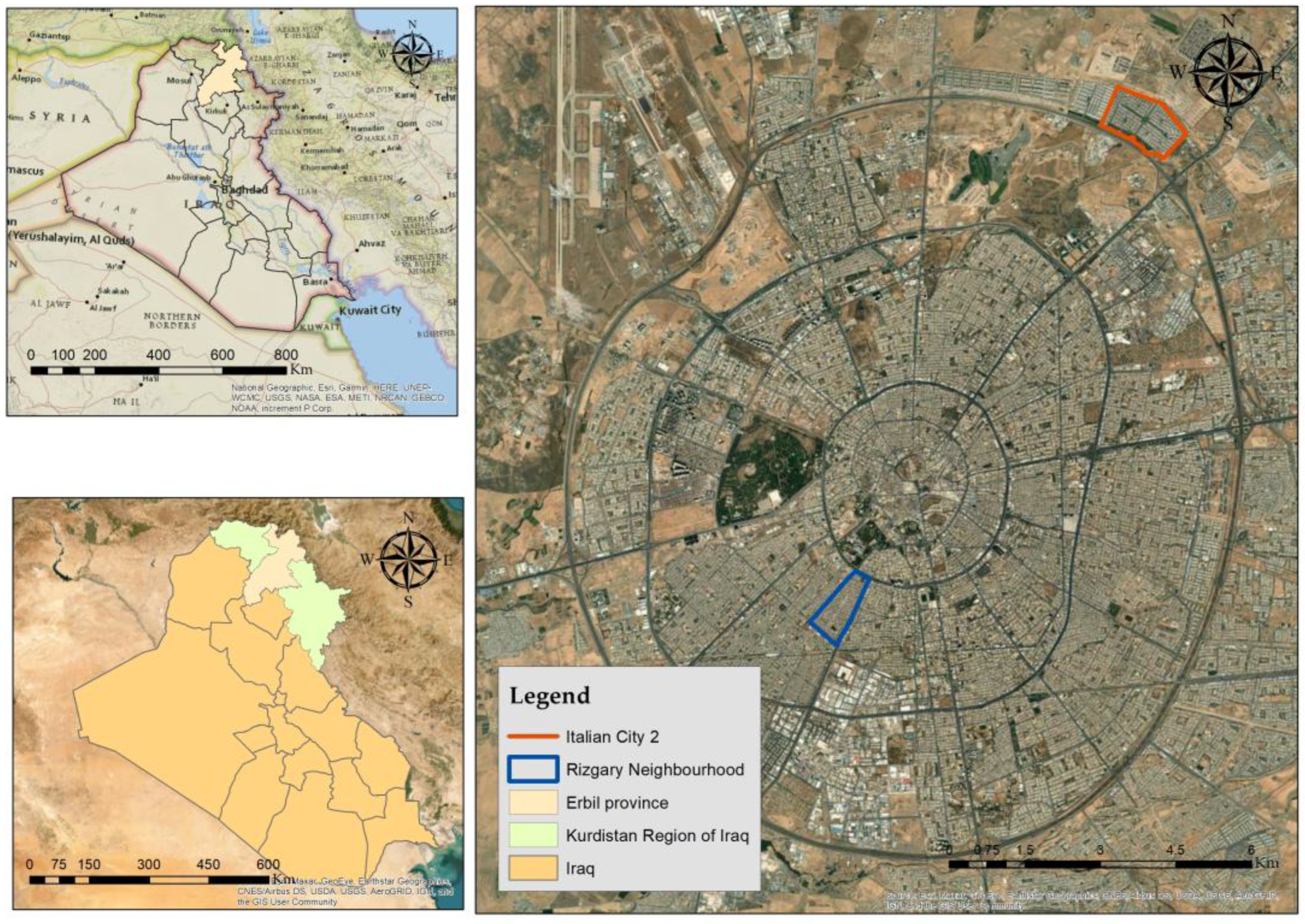
Figure 2.
(a) Site layout of the Italian city-2 neighborhood in northeastern Erbil. (b) General overview of the newly developed residential area.
Figure 2.
(a) Site layout of the Italian city-2 neighborhood in northeastern Erbil. (b) General overview of the newly developed residential area.
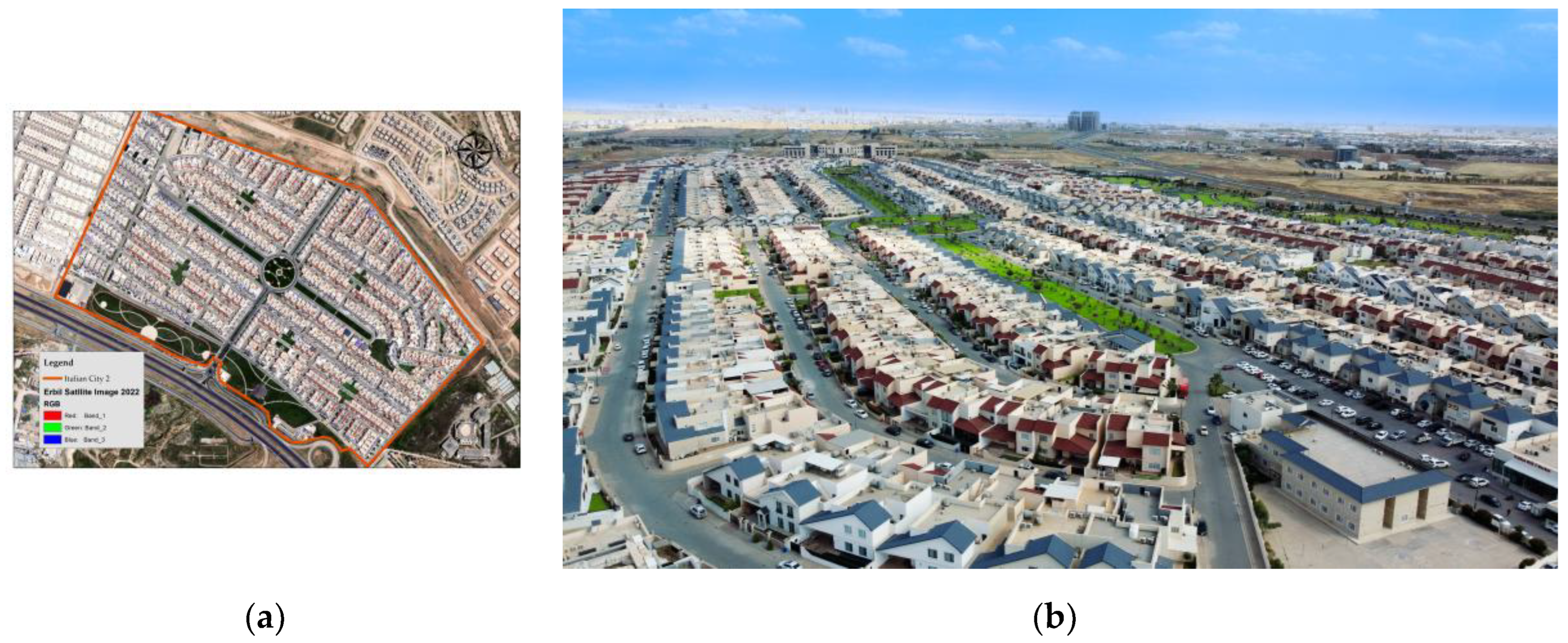
Figure 3.
Land use distribution in Italian city-2.
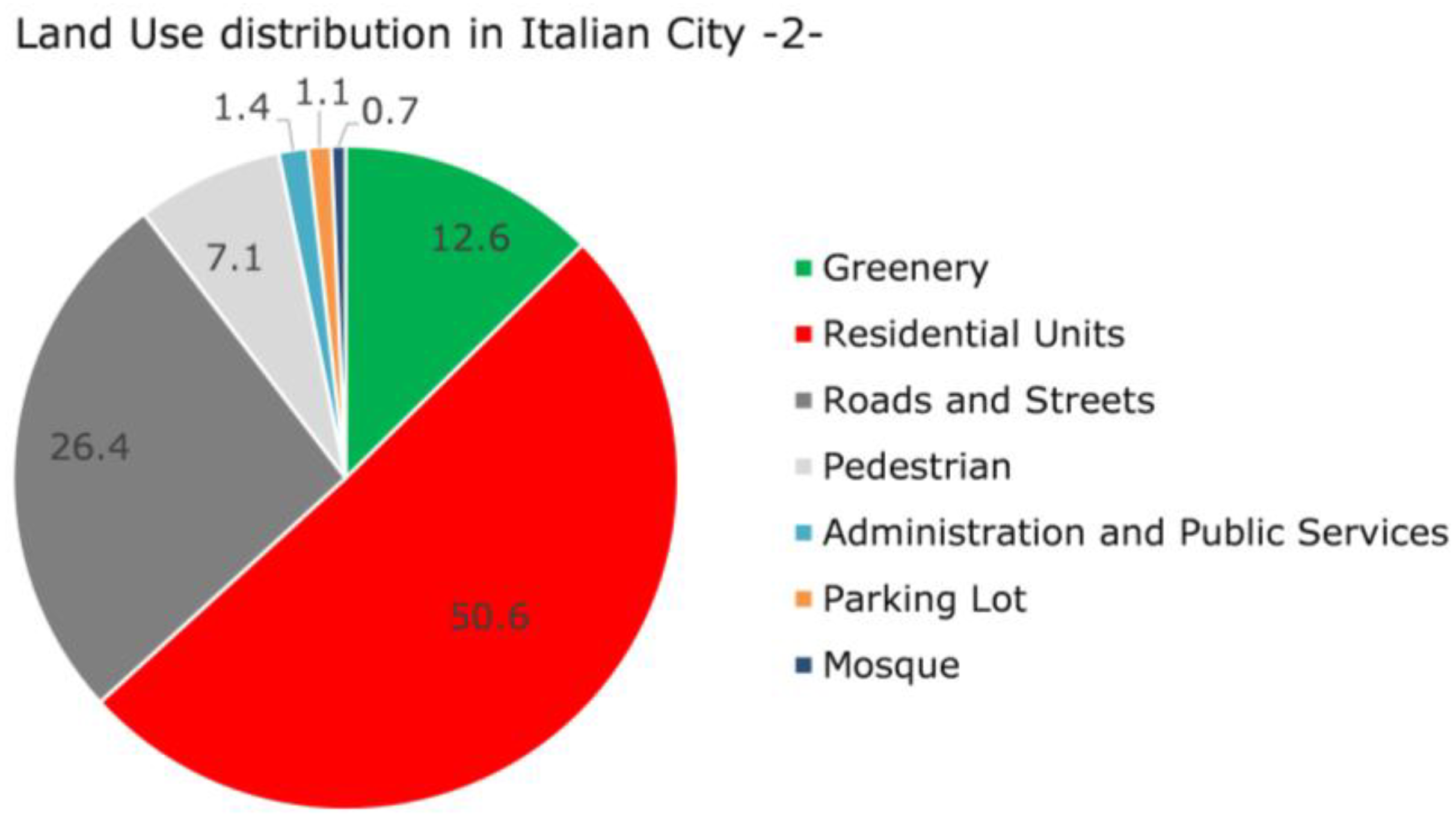
Figure 4.
Layout of Rizgary neighborhood (Kuran), an old and densely populated area in southwestern Erbil.
Figure 4.
Layout of Rizgary neighborhood (Kuran), an old and densely populated area in southwestern Erbil.
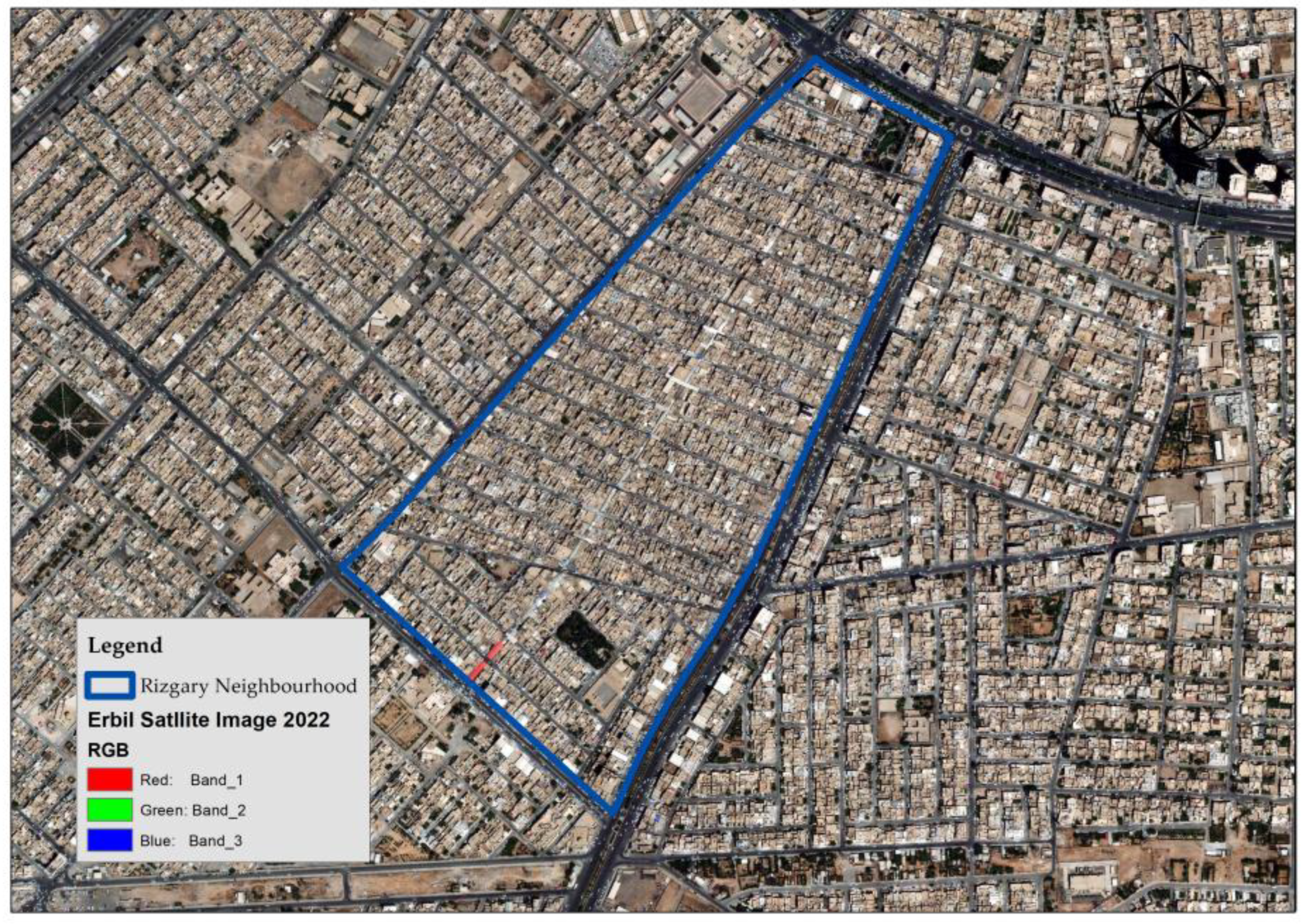
Figure 5.
Land use distribution in Rizgary neighborhood.
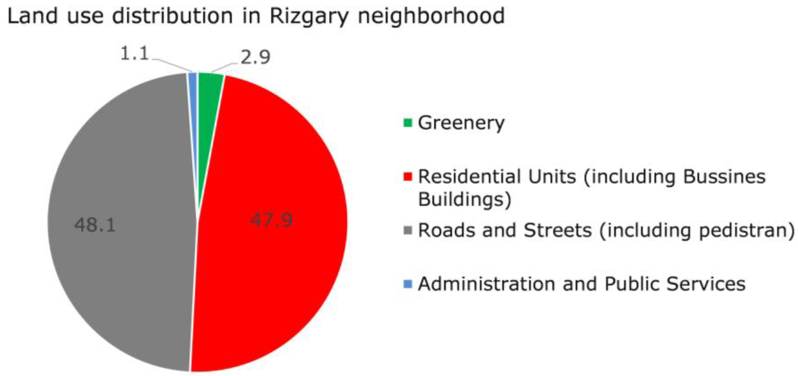
Figure 6.
LULC Percentage of pervious and impervious surfaces in Italian city-2.
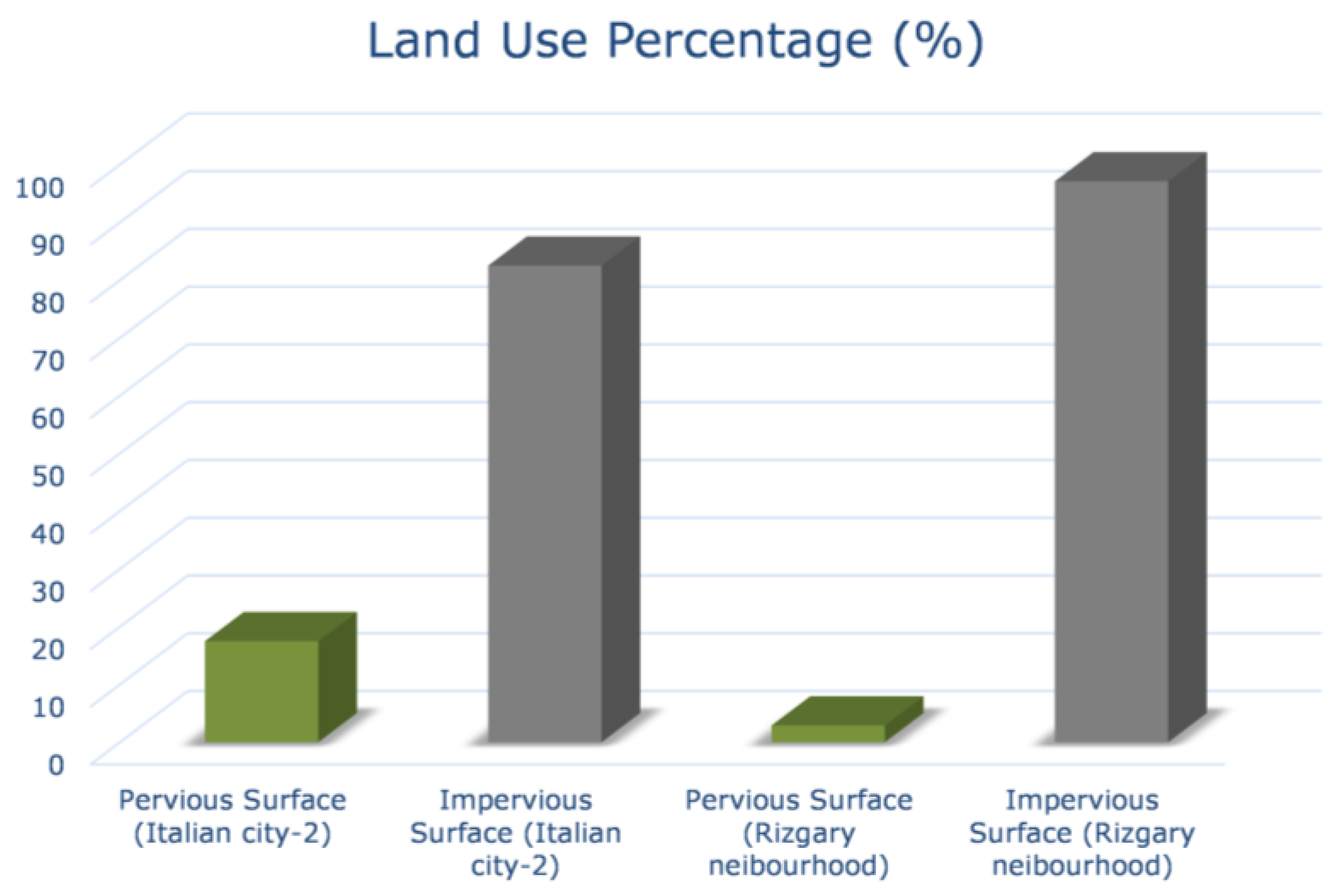
Figure 7.
Overview of housing types and land use characteristics in Italian city-2: (a) House Type A layout. (b) House Type B layout. (c) House Type C layout. (d) Pervious vs. impervious – Type A. (e) Pervious vs. impervious – Type B. (f) Pervious vs. impervious – Type C. (g) Area distribution – Type A. (h) distribution – Type B. (i) Area distribution – Type C.
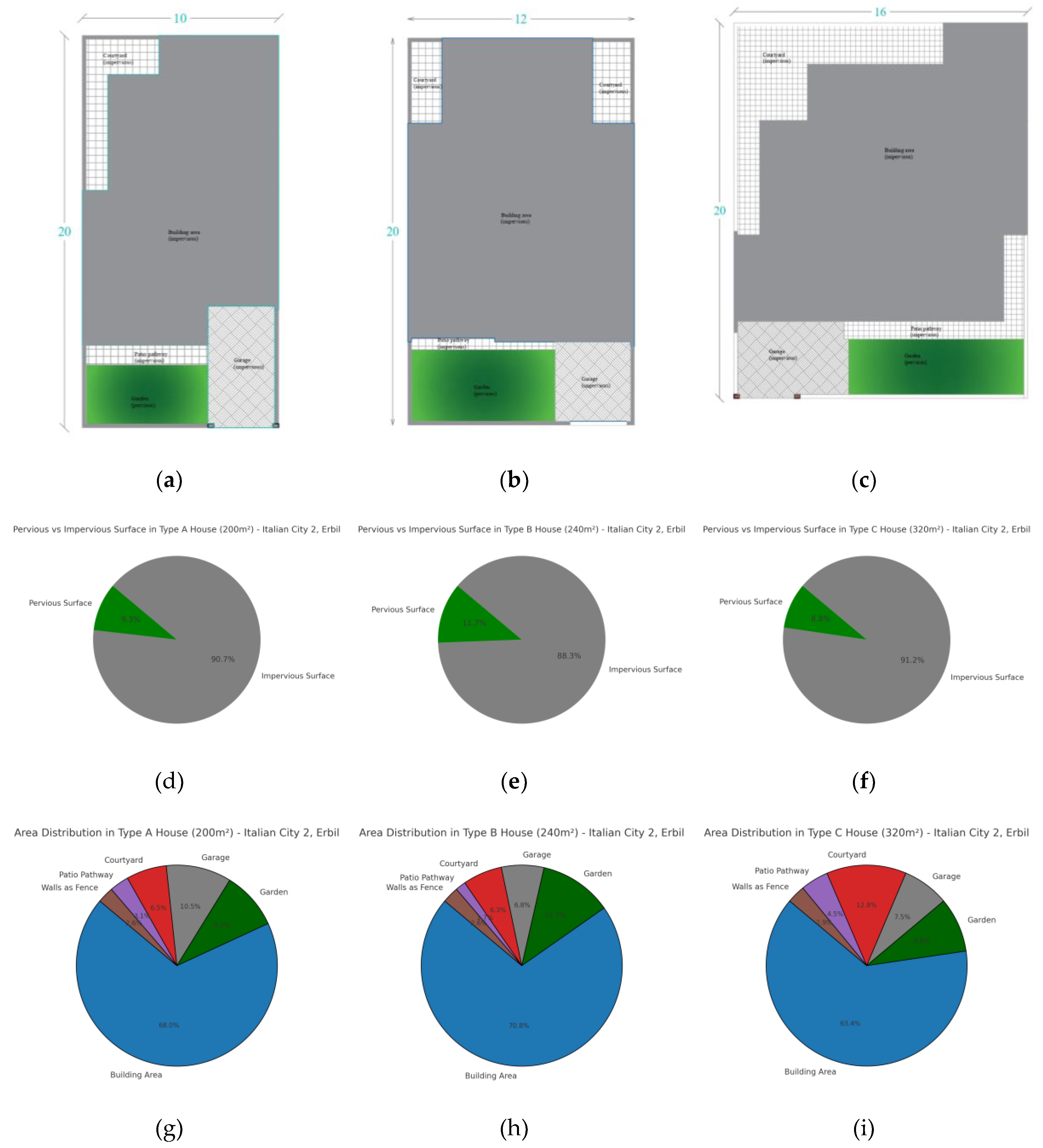
Figure 8.
Overview of housing types and land use characteristics in Rizgary Neighborhood: (a) Pervious vs. impervious – Type I. (b) Pervious vs. impervious – Type II. (c) Pervious vs. impervious – Type III.
Figure 8.
Overview of housing types and land use characteristics in Rizgary Neighborhood: (a) Pervious vs. impervious – Type I. (b) Pervious vs. impervious – Type II. (c) Pervious vs. impervious – Type III.
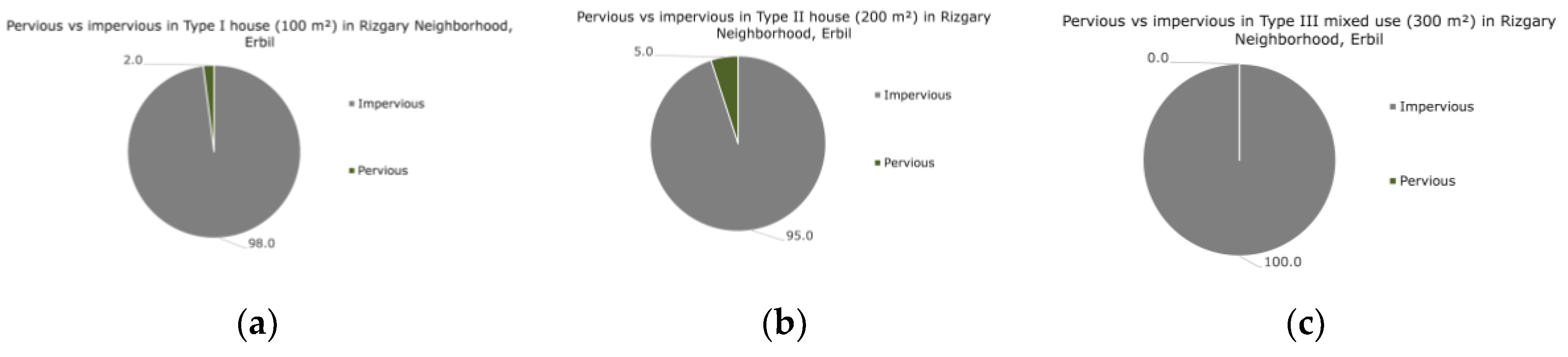
Figure 9.
Runoff volume (Q) pre and post construction under P1 % and P20 % rainfall scenarios, showing increased runoff due to urbanization.
Figure 9.
Runoff volume (Q) pre and post construction under P1 % and P20 % rainfall scenarios, showing increased runoff due to urbanization.
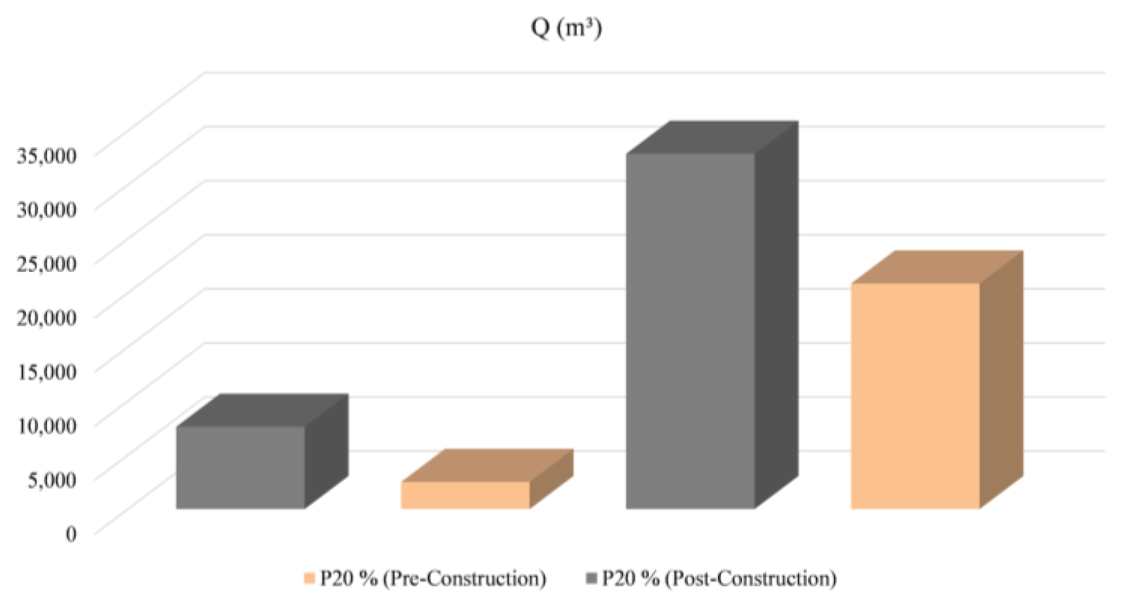
Table 1.
Runoff CN for the integration of different land cover and hydrological soil groups.
| LULC category | Runoff CN for different soil groups | |||
|---|---|---|---|---|
| A | B | C | D | |
| Impervious areas: Paved parking lots, roofs, driveways, etc. (excluding right of way) | 98 | 98 | 98 | 98 |
| Open space (lawns, parks, golf courses, cemeteries, etc.): Good condition (grass cover >75%) | 39 | 61 | 74 | 80 |
Table 2.
Calculated surface runoff volumes (Q, in m³) for residential house types (A, B, and C) in Italian city-2 using the SCS-Curve Number method, under two rainfall probabilities (1 % and 20 %) and storm durations of 60 and 1440 minutes.
Table 2.
Calculated surface runoff volumes (Q, in m³) for residential house types (A, B, and C) in Italian city-2 using the SCS-Curve Number method, under two rainfall probabilities (1 % and 20 %) and storm durations of 60 and 1440 minutes.
| House Type | Time (60 min) | Time (1440 min) | ||
|---|---|---|---|---|
| Q(m3) for P1% | Q(m3) for P20% | Q(m3) for P1% | Q(m3) for P20% | |
| Type A | 4.98 | 2.33 | 16.66 | 8.66 |
| Type B | 5.69 | 2.59 | 19.62 | 10.06 |
| Type C | 8.04 | 3.79 | 26.77 | 13.94 |
Table 3.
Calculated surface runoff volumes (Q, in m³) for residential house types (I, II, and III) in Rizgary neighborhood the SCS-Curve Number method, under two rainfall probabilities (1% and 20%) and storm durations of 60 and 1440 minutes..
Table 3.
Calculated surface runoff volumes (Q, in m³) for residential house types (I, II, and III) in Rizgary neighborhood the SCS-Curve Number method, under two rainfall probabilities (1% and 20%) and storm durations of 60 and 1440 minutes..
| House Type | Time (60 min) | Time (1440 min) | ||
|---|---|---|---|---|
| Q(m3) for P1% | Q(m3) for P20% | Q(m3) for P1% | Q(m3) for P20% | |
| Type I | 2.88 | 1.48 | 8.82 | 4.77 |
| Type II | 5.42 | 2.68 | 17.24 | 9.17 |
| Type III | 9.00 | 4.73 | 26.89 | 14.70 |
Disclaimer/Publisher’s Note: The statements, opinions and data contained in all publications are solely those of the individual author(s) and contributor(s) and not of MDPI and/or the editor(s). MDPI and/or the editor(s) disclaim responsibility for any injury to people or property resulting from any ideas, methods, instructions or products referred to in the content. |
© 2025 by the authors. Licensee MDPI, Basel, Switzerland. This article is an open access article distributed under the terms and conditions of the Creative Commons Attribution (CC BY) license (http://creativecommons.org/licenses/by/4.0/).
Copyright: This open access article is published under a Creative Commons CC BY 4.0 license, which permit the free download, distribution, and reuse, provided that the author and preprint are cited in any reuse.


