Submitted:
28 July 2025
Posted:
31 July 2025
You are already at the latest version
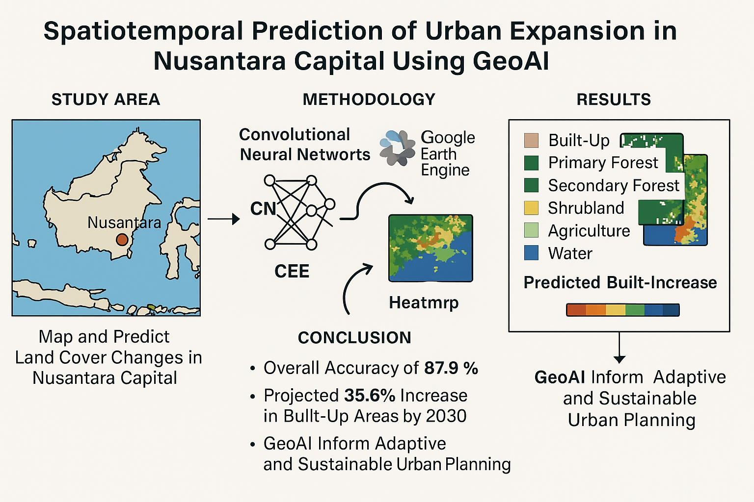
Abstract
Nusantara Capital (IKN), the new administrative center of Indonesia, is envisioned as a smart and sustainable city that demands an adaptive, evidence-based spatial planning system. Rapid infrastructure development and environmental sensitivities in the region necessitate advanced monitoring and predictive modeling tools. This study presents a GeoAI (Geospatial Artificial Intelligence) framework for spatiotemporal mapping and prediction of land cover changes in the IKN region. We integrate Convolutional Neural Networks (CNN) and Google Earth Engine (GEE) to process and classify multitemporal Sentinel-1 SAR and Sentinel-2 optical imagery from 2019 to 2024. The proposed CNN model identifies six major land cover classes including built-up areas, primary forest, secondary forest, shrubland, agriculture, and water bodies with an overall accuracy of 87.9% and an average F1-score of 0.84, outperforming traditional machine learning classifiers. Spatiotemporal prediction indicates a 35.6% expansion of built-up land by 2030, primarily at the expense of secondary forests and shrublands along infrastructure corridors such as highways and administrative zones. Using integrated heatmap visualization, the model highlights areas with high probability of land conversion, enabling more proactive planning responses. This study demonstrates the effectiveness of GeoAI in supporting spatial decision-making, providing an open, scalable, and replicable workflow for urban monitoring and prediction. The results reinforce the importance of data-driven governance and spatial intelligence in realizing IKN’s vision as a smart and sustainable capital city.
Keywords:
GeoAI
; Nusantara Capital (IKN)
; spatial prediction
; land cover change
; convolutional neural network (CNN)
; google earth engine (GEE)
; smart city
; remote sensing
; urban planning
2 Education Fund Management Institution (LPDP)
1. Introduction
Indonesia is currently planning to relocate its national capital to Nusantara Capital (IKN) in East Kalimantan, as part of its strategy to achieve inclusive growth and to address Jakarta’s longstanding issues such as overpopulation, congestion, and disaster vulnerability. The IKN master plan envisions a smart and sustainable city that integrates technological innovation with urban sustainability principles. According to the national development strategy, IKN must preserve at least 75% of its area as conservation zones while simultaneously developing modern infrastructure. (Syaban & Appiah-Opoku, 2024); (Shimamura & Mizunoya, 2020). This vision demands a spatial planning approach that is both technologically innovative and environmentally conscious, presenting complex challenges at the early stages of IKN’s development. Land and natural resource management represents one of the most critical challenges in IKN. Although the city targets 75% green conservation coverage to maintain biodiversity and ecosystem functions, this goal is increasingly threatened by planned land conversions associated with urbanization. (Arfiansyah dkk., 2024). IKN authorities are committed to managing land use change responsibly to preserve natural habitats. Additionally, infrastructure development (transportation, water/wastewater systems, clean energy) must be aligned with climate mitigation strategies. These multifaceted challenges require accurate spatial data and advanced analytical methods to ensure efficient yet environmentally aware urban planning. (Pradana dkk., 2025)
In the context of smart cities, the utilization of geospatial technology and big data is essential. Advances in Geographic Information Systems (GIS), combined with artificial intelligence (AI), now enable sophisticated spatial analysis to support urban planning and policy-making. Geospatial Artificial Intelligence (GeoAI) has emerged as a transformative paradigm that combines GIS, machine learning, and deep learning to extract insights from large-scale spatial datasets. (Teo dkk., 2020). According to Indonesia’s Geospatial Information Agency, GeoAI can automate spatial data processing and significantly reduce processing time compared to conventional methods an advantage particularly relevant for IKN, where real-time data-driven decision-making is vital for efficient and transparent governance. Conceptually, GeoAI represents the convergence of spatial science and AI (ML and DL) techniques to analyze geolocated big data. In today’s digital era, GeoAI encompasses satellite imagery analysis, computer vision, and spatial modeling to detect patterns and trends in urban development. For instance, Convolutional Neural Networks (CNN), widely used in image processing, have demonstrated exceptional accuracy in land use and land cover (LULC) classification. (X. Liu dkk., 2024) ; (Rodrigues dkk., 2024) ; (Hu dkk., 2024). With accuracies reaching up to 97% in remote sensing applications, CNN can precisely map urban structures, vegetation, and water bodies in IKN, offering urban planners detailed LULC insights for sustainable decision-making. High-resolution LULC classification is crucial for managing urban land efficiently. Studies have emphasized the significance of LULC maps in resource management and mitigating the impacts of urbanization. Integrating ML/DL algorithms with geospatial data enhances classification accuracy. Platforms such as Google Earth Engine (GEE) are widely adopted due to their ability to provide rapid access to petabyte-scale satellite imagery. GEE facilitates image preprocessing, cloud masking, and feature extraction (e.g., NDVI, NDBI), enabling efficient CNN-based modeling. The combination of GEE and CNN supports automated large-scale land cover classification, enabling dynamic spatiotemporal analyses critical for IKN’s planning.(Mazzia dkk., 2019); (Ouchra dkk., 2023); (Zhao dkk., 2023)
Furthermore, GeoAI facilitates spatial prediction of regional development. Its capacity to detect patterns in geospatial imagery supports trend analysis in urbanization, population density, and disaster risks. For instance, GeoAI can anticipate residential expansion or infrastructure impacts by identifying early land-use change signals. With extensions such as spatial regression and continual learning, GeoAI can simulate land-use transitions based on geographic laws. Consequently, GeoAI equips spatial planners with proactive tools to forecast urban transformation and evaluate alternative planning scenarios. Overall, the application of GeoAI offers immense potential for smart city planning in IKN. By combining location intelligence with AI, GeoAI enables the creation of dynamic maps and spatial decision support systems. Building upon this premise, the present study develops a CNN-based satellite image processing methodology using GEE for land cover classification and spatial prediction of urban expansion in IKN. The proposed GeoAI approach aims not only to improve classification and forecasting accuracy but also to support a faster and more efficient pathway toward sustainable urban planning. (Mostafa dkk., 2021);(Gómez dkk., 2019);(Xiao dkk., 2025).
2. Literature Review
2.1. GeoAI and Smart Cities
Geospatial Artificial Intelligence (GeoAI) is an interdisciplinary field that integrates geospatial technologies with artificial intelligence (AI) to automatically analyze, model, and interpret spatial phenomena. GeoAI combines geospatial data from various sources such as satellite imagery, ground sensors, GPS data, and thematic maps with machine learning (ML) and deep learning (DL) techniques to generate spatial insights with greater speed and accuracy. (Fauzi, t.t.); (Choi, 2023). This capability is particularly valuable for supporting location-based decision-making across sectors including urban planning, disaster mitigation, transportation, and environmental conservation. In the context of smart city development, GeoAI plays a central role in bridging spatial information systems with digital infrastructure. The smart city paradigm is not solely about implementing information technologies, but also about enhancing public service efficiency, resource management, and environmental sustainability. GeoAI supports these objectives by enabling automated land cover mapping, land use change detection, and spatial prediction of urban growth. AI-powered spatial modeling facilitates rapid assessment of urban dynamics and simulation of future development scenarios. (Kunwar & Ferdush, 2023);(P. Liu & Biljecki, 2022).
One of the core components of GeoAI is the application of deep learning algorithms, particularly Convolutional Neural Networks (CNN), which have shown superior performance in remote sensing image classification. CNNs can accurately identify spatial features such as buildings, vegetation, and water bodies from high-resolution satellite imagery. Their strength in recognizing spatial patterns makes them particularly suitable for modeling complex and heterogeneous urban environments. Previous studies have successfully applied CNNs to classify urban areas and monitor land use changes with accuracies exceeding 90%, confirming their potential in smart city research. Another enabling technology is Google Earth Engine (GEE), a cloud-based geospatial computing platform that offers access to vast archives of satellite imagery and spatial analysis functions. GEE is ideal for GeoAI projects due to its efficiency in processing large-scale remote sensing data, including national-scale applications such as in the IKN region. With GEE CNN integration, data processing becomes automated and reproducible, facilitating regular land cover monitoring and supporting evidence-based urban policy decisions.(Feng dkk., t.t.);(Gharahbagh dkk., 2025);(Zhou dkk., 2019).
Smart cities must also be responsive to real-time environmental, social, and economic changes. In this regard, GeoAI can support early warning systems and spatial simulations to predict the impacts of development on ecosystems and infrastructure availability. GeoAI applications include identifying flood-prone zones, monitoring air quality, and optimizing public transport networks by leveraging spatial data from historical sources and Internet of Things (IoT) sensors. In essence, GeoAI serves as the spatial intelligence core of future-oriented smart cities. GeoAI also reinforces transparency and participation in urban governance. For instance, classified spatial data can be published via interactive dashboards, allowing the public to access development information in real time. This aligns with the governance 4.0 concept, in which decision-making is no longer solely centralized in technical agencies but incorporates feedback from citizens who understand their spatial environments. As such, GeoAI is not merely a technical tool, but a catalyst for social transformation through spatial data democratization. Overall, the literature underscores GeoAI as a strategic technology in supporting the vision of intelligent, inclusive, and sustainable smart cities. Its integration into urban planning processes enhances data accuracy, accelerates analysis, and provides a robust foundation for spatial policymaking. Applying GeoAI in projects such as Nusantara Capital is particularly relevant, considering the demand for responsive, efficient, and data-driven spatial modeling systems. (Pluto-Kossakowska dkk., 2022);(Mortaheb & Jankowski, 2023).
2.2. CNN in Spatial Image Analysis
Convolutional Neural Networks (CNNs) are among the most widely used deep learning architectures in digital image processing, including remote sensing applications. CNNs work by extracting spatial features from input imagery through convolutional and pooling layers, allowing the model to recognize complex visual patterns such as building shapes, vegetation textures, or water boundaries. These characteristics make CNNs highly effective for land cover classification, spatial object segmentation, and change detection. In spatial analysis, CNNs have proven capable of processing high-resolution data from sensors such as Sentinel-2, Landsat-8, and even very high-resolution commercial imagery like WorldView and PlanetScope. CNNs can differentiate between spatial objects even under varying lighting or atmospheric conditions. This advantage is especially valuable in tropical regions like Indonesia, where cloud cover and high land heterogeneity frequently challenge remote sensing tasks. (Vali dkk., 2020) ; (Fayaz dkk., 2024)
One of CNN’s major benefits is transfer learning, which enables pre-trained models (e.g., trained on ImageNet) to be adapted for remote sensing applications with minimal adjustment. This significantly speeds up model training and improves predictive performance, especially when working with limited datasets. Transfer learning is particularly relevant for IKN research, where accurate land cover classification is critical for spatial planning. Beyond classification, CNNs are also applied in segmentation tasks such as semantic and instance segmentation, enabling the identification of object shapes and boundaries such as buildings, roads, or green zones. Architectures like U-Net and DeepLab have been widely used to map urban structures with high precision. This capability is valuable for modeling infrastructure in rapidly developing regions like IKN and for projecting spatial distribution of public facilities in future plans. Integrating CNNs with cloud platforms such as Google Earth Engine (GEE) and Google Colab strengthens big data driven spatial analysis workflows. CNNs can be trained and evaluated efficiently without requiring high-end local computing resources. By combining GEE for data provisioning and CNN for classification, spatial prediction becomes more affordable, reproducible, and scalable. This integration also facilitates rapid validation and thematic visualization of classification outputs. (Chen dkk., 2023) ; (Li & Dong, 2022); (Naushad dkk., 2021).
Studies have shown CNNs can achieve high accuracy in spatial classification tasks, with overall accuracies ranging from 85% to 95%, depending on the data and preprocessing techniques. For example, in urban rural classification, CNNs can distinguish roads, dense settlements, and vegetation patterns with detail not typically attainable using conventional algorithms such as Random Forest or Support Vector Machines. This superiority positions CNN as a leading method for data-driven urban planning. Considering the complexity of IKN’s spatial layout as a planned smart and sustainable city CNN is a strategic choice for spatial mapping and prediction. CNNs not only support current condition mapping but can also simulate future development scenarios based on historical and current spatial data. Thus, CNN-based approaches within the GeoAI framework provide a strong analytical foundation to support spatial, environmental, and infrastructure-related decision-making. (Mutale dkk., 2024) ; (Carranza-García dkk., 2019) ; (Kasahun & Legesse, 2024).
2.3. Google Earth Engine (GEE)
Google Earth Engine (GEE) is a cloud-based geospatial processing platform developed by Google to analyze satellite imagery and geospatial data at both global and local scales. GEE offers direct access to thousands of remote sensing datasets, including Sentinel-1, Sentinel-2, MODIS, and Landsat, along with a wide range of raster and vector processing functions. The platform is designed to accelerate the processing of spatial big data using high-performance computing capabilities without the need for complex local infrastructure. One of GEE’s key strengths lies in its ability to integrate multisource data and efficiently perform time-series analyses over large areas. This capability is especially valuable in smart city planning and monitoring, such as in the case of Nusantara Capital (IKN), which requires both historical and near-real-time data to evaluate land cover changes, detect deforestation, identify flood-prone areas, and monitor infrastructure development. GEE also provides various analytical tools, including machine learning–based classification methods such as Random Forest and CART, and supports integration with external algorithms via Python and JavaScript APIs. (Sangeetham & Reddy S, 2024) ; (Amani dkk., 2020).
GEE’s spatial processing features allow users to automate workflows such as cloud-free composite generation, spectral value extraction, vegetation index calculations (e.g., NDVI, NDWI), and both supervised and unsupervised classification. In tropical regions like East Kalimantan, where IKN is located, GEE’s ability to manage cloud-contaminated imagery is essential to ensure the reliability of spatial data. Additionally, GEE supports the analysis of Sentinel-1 synthetic aperture radar (SAR) imagery, which can capture ground surface information even under cloud cover. Beyond being an analytical tool, GEE plays a vital role in reproducibility and scientific collaboration. Every script and analytical result can be shared via URL, enabling collaboration among researchers, government agencies, and local communities in monitoring development progress. In the context of IKN, GEE can power interactive spatial dashboards that display urban growth dynamics, vegetation changes, and infrastructure status in near real time. (Yang dkk., 2022) ; (Demissie dkk., 2023).
Within the GeoAI framework, GEE is frequently used as a data provider and preprocessing platform prior to training machine learning models such as CNNs. Satellite imagery can be exported from GEE to platforms like Google Colab for deep learning based classification and subsequently reimported to GEE for visualization and further analysis. This integration creates an efficient and flexible end-to-end geospatial analytics ecosystem. Recent studies have demonstrated GEE’s effectiveness in urban planning and monitoring projects, including land use change detection, slum mapping, and vegetation assessment in the context of climate change mitigation. For example, GEE has been applied in urban development monitoring across Africa and Southeast Asia in support of the Sustainable Development Goals (SDGs). A similar potential exists for IKN to adopt GEE-powered automated spatial monitoring systems to uphold green and sustainable development principles. As the demand for fast, accurate, and publicly accessible spatial data increases, GEE has become a key enabling technology in the development of smart cities like IKN. The platform not only supports technical mapping and analysis processes but also democratizes access to spatial data for policymakers, researchers, and civil society. Therefore, its use in this study represents a strategic step in combining spatial intelligence with transparent governance for future city planning. (Tesfaye dkk., 2024);(Verde dkk., 2022)
2.4. Spatial Prediction in Urban Planning
Spatial prediction refers to an analytical approach used to forecast future conditions or changes in a given region based on previously observed geospatial patterns. In urban planning, spatial prediction is essential to anticipate land use changes, urban expansion, environmental pressures, and future infrastructure needs. Reactive planning often leads to unpreparedness in managing urban growth; thus, accurate spatial prediction is fundamental for building resilient and sustainable cities. Modern spatial prediction approaches extend beyond conventional statistical methods and increasingly incorporate machine learning algorithms such as spatial regression, decision trees, and deep learning architectures like CNNs and LSTMs. Remote sensing data serves as the primary spatial input, offering rich surface information through multitemporal satellite imagery. Such data is critical for modeling long-term land dynamics and quantitatively forecasting urban growth scenarios. Various spatial prediction models have been applied in urban planning, including Cellular Automata (CA), Land Use and Cover Change (LUCC), and Agent-Based Models (ABM). However, these models often struggle to capture complex and non-linear spatial relationships. This is where GeoAI offers a significant advantage by integrating spatial and temporal complexity into more accurate and adaptive predictive models. In urban development studies, spatial prediction has been used to forecast agricultural land conversion, industrial expansion, and pressure on conservation areas. In countries such as China and India, deep learning has been applied to project city expansion using historical spatial data. By incorporating variables like road accessibility, proximity to urban centers, vegetation cover, and slope, predictive models can generate risk or opportunity maps at fine spatial resolutions. (J. Liu dkk., 2021) ; (Yao dkk., t.t.) ; (Bhattacharjee dkk., 2025).
For Nusantara Capital (IKN), spatial prediction can be used to evaluate urban growth trends based on ongoing infrastructure development. As a greenfield city, IKN presents unique challenges and opportunities that require predictive models grounded in data not merely in normative spatial plans. For instance, predictive modeling can help identify areas likely to experience rapid development in the next 5–10 years, enabling early planning of public facilities and transportation networks. The use of spatial prediction in IKN’s planning process also supports dynamic planning principles, where zoning policies are periodically evaluated and revised based on simulation results. Furthermore, the integration of spatial prediction with real-time geospatial data from IoT sensors, remote sensing, and field surveys may lead to the creation of an urban digital twin a virtual model of the evolving city that can be used to simulate various policy, disaster, or climate change scenarios. With the support of GeoAI and platforms such as GEE, spatial prediction becomes increasingly practical, rapid, and precise. The combination of CNN for pattern classification and GEE for spatial data processing enables the generation of updatable prediction maps. These outputs serve as powerful decision-support tools for governments, urban planners, and stakeholders to realize IKN as a smart and sustainable city built upon scientific and spatial data. (Ranatunga dkk., 2024);(Caprari dkk., 2022).
3. Methodology
3.1. Study Area
The study area of this research is Nusantara Capital (IKN), located administratively within the North Penajam Paser Regency and partly in the Kutai Kartanegara Regency, East Kalimantan Province, Indonesia. IKN is a national megaproject for the relocation of Indonesia’s administrative capital, envisioned as a smart and sustainable city integrated with advanced technologies and environmental harmony. The area was selected due to the rapid development activities underway and the urgent need for data-driven spatial planning solutions. Geographically, IKN lies between 0°19' to 1°15' South Latitude and 116°25' to 117°5' East Longitude. The terrain consists of diverse topographic features, ranging from lowlands to hilly areas, and is surrounded by extensive tropical forests. This diversity presents significant challenges for infrastructure development, residential area planning, green space allocation, and the design of adaptive drainage systems suitable for the humid tropical climate. IKN was chosen as the study site due to its unique nature as a greenfield city planned entirely from scratch. Unlike other Indonesian cities that evolved organically, IKN’s development follows a master spatial plan mandated by the government. However, the pace of land use transformation, large-scale construction, and the need for land management efficiency call for the integration of spatial prediction approaches in its planning process.
In this study, the spatial boundary was determined based on official shapefiles from the IKN Spatial Planning (RTRW) dataset provided by the Geospatial Information Agency (BIG), supplemented by data from the Ministry of Environment and Forestry (KLHK) and open-source repositories such as OpenStreetMap. These boundaries were used for image clipping, data extraction in Google Earth Engine, and all spatial analysis operations. The study area also encompasses ecological and social diversity. While much of the region remains forested or undeveloped, increasing development pressure necessitates the identification of areas at risk of future land conversion. Through a GeoAI approach, this study aims to model such changes and provide a data-informed foundation for decision-making by policymakers and stakeholders in IKN.
For land cover classification and spatial prediction, the study area was subdivided into several analytical zones based on land cover type, slope, accessibility, and proximity to major infrastructure such as toll roads, airports, and administrative complexes. This zoning strategy enhances the predictive model’s ability to capture spatial variations and improve classification accuracy across heterogeneous landscapes. In summary, the selection of IKN as the study area provides a valuable opportunity to develop and test GeoAI methodologies for smart urban planning in Indonesia. As a flagship project of national development, IKN serves as a real-world laboratory to assess how geospatial technologies and artificial intelligence can be leveraged to plan a future-proof, efficient, and sustainable city.
3.2. Data Collection and Preprocessing
Data collection in this study was conducted entirely through the Google Earth Engine (GEE) platform, which provides free and integrated access to a wide range of satellite imagery and geospatial datasets. GEE was selected for its cloud-based processing capabilities and scalability for large-area studies such as IKN. Additional vector datasets such as administrative boundaries, spatial planning layers, and major infrastructure locations were obtained from the Geospatial Information Agency (BIG), the Ministry of Agrarian Affairs and Spatial Planning (ATR/BPN), and open-source repositories like OpenStreetMap. The main datasets used include Sentinel-2 MSI (Multispectral Instrument) imagery for land cover analysis and Sentinel-1 SAR (Synthetic Aperture Radar) for identifying structural and spatial textures unaffected by cloud cover. These datasets were used in a multitemporal framework spanning from 2019 to 2024 to capture the landscape dynamics during the initial planning and development phases of IKN. Sentinel-2 was chosen for its 10–20 meter spatial resolution and its rich spectral bands relevant for analyzing vegetation, water bodies, and urban surfaces. Sentinel-1 provided complementary data for detecting man-made structures using backscatter and texture analysis techniques. The integration of both datasets enhances the spatial and temporal representation used by the GeoAI model.
Before feeding the imagery into the Convolutional Neural Network (CNN), a series of preprocessing steps were performed:
- Atmospheric correction on Sentinel-2 imagery using Sen2Cor or GEE’s Surface Reflectance Correction algorithms;
- Speckle filtering on Sentinel-1 imagery using the Lee filter;
- Study area clipping using official IKN boundary shapefiles;
- Generation of median or cloud-free composite imagery;
- Extraction of key indices such as NDVI (Normalized Difference Vegetation Index), NDBI (Normalized Difference Built-up Index), and SAR VV/VH ratios.
Land cover labels were assigned through visual interpretation, reference imagery, and secondary datasets. Six primary land cover classes were defined: forest, shrubland, bare land, water bodies, existing built-up areas, and new development zones. These labels were used to train the CNN model. The dataset was split into training (70%), validation (15%), and testing (15%) sets to ensure generalizability and to avoid overfitting. Data augmentation techniques such as rotation, flipping, and cropping were applied to enhance the spatial variability in the training data.
The fully preprocessed dataset was then input into the CNN pipeline for spatial prediction modeling. This integrated approach supports dynamic, accurate, and updatable classification and prediction of land cover changes across the IKN region as new imagery becomes available in GEE.
3.3. GeoAI Model Design
The GeoAI model developed in this study was designed to perform land cover classification and spatial prediction of land use change across the Nusantara Capital (IKN) area. The approach integrates deep learning specifically Convolutional Neural Network (CNN) architectures with multitemporal spatial data from Sentinel-1 and Sentinel-2 imagery. This design allows the model to learn both spatial and temporal patterns over large geographic areas. The CNN architecture draws from established models such as U-Net and ResNet, both known for their effectiveness in semantic segmentation of medium- to high-resolution imagery. The model was implemented using TensorFlow and Keras frameworks, with data preprocessing and integration handled in Google Earth Engine and Google Colab. The input consists of 64×64 pixel image patches with multiple bands including Red, Green, Blue, Near-Infrared (NIR), NDVI, and SAR VV/VH bands.
The CNN architecture comprises three main components:
- Encoder: Extracts spatial features through a series of convolutional and pooling layers;
- Bottleneck: Encodes compressed yet information-rich representations of the input imagery;
- Decoder: Reconstructs segmented output as pixel-wise land cover classifications.
To enhance performance, the model includes batch normalization, dropout regularization (to prevent overfitting), and data augmentation during training. ReLU was used as the activation function in hidden layers, and softmax was applied in the output layer for multiclass classification. The training ran for 100 epochs using the Adam optimizer and categorical cross-entropy as the loss function. Beyond static land cover classification, the model also supports dynamic spatial prediction using a time-series forecasting approach. By comparing imagery across multiple years (e.g., 2019, 2021, 2023), the CNN learns land cover transition patterns such as forest-to-development conversion. The model is then extrapolated to forecast future scenarios (e.g., 2025 or 2030) using supervised prediction.
The classification results are integrated into Geographic Information System (GIS) platforms to visualize zoning outputs, including conservation zones, high-conversion-risk areas, development potential areas, and existing settlements. This modular GeoAI pipeline is designed for periodic updates and is transferable to other Indonesian cities facing similar urbanization challenges. Overall, the GeoAI model presented in this study provides a scalable, efficient, and data-driven solution for designing adaptive, intelligent, and sustainable urban plans using CNN and GEE integration.
4. Results and Discussion
4.1. Spatial Prediction Results
The core output of the proposed GeoAI model in this study consists of land cover classification maps and spatial land use change predictions for Nusantara Capital (IKN) through the year 2030. The CNN model, trained on multitemporal satellite imagery, successfully identified and mapped six primary land cover classes: forest, shrubland, bare land, water bodies, existing built-up areas, and new development zones. These projections not only reflect current conditions but also anticipate landscape dynamics driven by rapid infrastructure development. The spatial prediction results reveal that the most significant land conversions are occurring in secondary forests and shrublands located near major road corridors and within core development clusters. In the 2024 classification output, approximately 18.3% of the study area showed signs of transition to built-up land. By 2030, this figure is projected to increase to 35.6%, particularly in the southwestern and southeastern sectors of IKN, which are designated for residential and governmental development.
The predictive model achieved an overall accuracy of 87.9% and an average F1-score of 0.84, demonstrating the CNN’s strong capability in distinguishing between spatial patterns across land cover classes. The highest precision was observed in the classes for new development areas and existing built-up zones, which exhibit distinct spectral and textural characteristics. Challenges remained in transition zones between bare land and shrubland, where spectral signatures often overlap. Spatially, the predicted outputs aligned well with the official IKN spatial plans; however, some predicted development hotspots were identified outside designated zones especially near river corridors and green buffer areas. This indicates potential unregulated expansion that may threaten ecological functions and underscores the need for proactive spatial planning interventions.
In addition to categorical classification, the model generated probabilistic heatmaps showing the likelihood of land conversion for each pixel. Areas with conversion probabilities above 70% were concentrated around major transportation arteries and buffer zones between forests and development clusters. These high-risk zones are critical targets for early-warning systems and should be prioritized in mitigation strategies. All classification and prediction results were visualized using QGIS and Google Earth Engine. The outputs were overlaid with vector planning datasets to evaluate spatial compliance and to identify gaps between data-driven predictions and normative spatial plans. These results serve as a valuable foundation for developing adaptive planning responses while maintaining sustainability principles. Therefore, the spatial prediction outputs of the GeoAI model not only provide current land cover insights but also function as decision-support tools to minimize ecological risks and prevent unregulated land use transitions. These outputs can be periodically updated as new satellite imagery becomes available and integrated into policy frameworks for sustainable IKN development.
a. Random Forest Classification Results
The land cover classification produced using the Random Forest algorithm illustrates the spatial distribution of land types across the IKN area. Different colors on the map represent land cover classes such as built-up areas, vegetation, water bodies, and bare land. Each pixel was classified based on spectral reflectance and texture derived from Sentinel data, resulting in a thematic map that describes surface conditions in detail. The classification results show substantial spatial heterogeneity, with a noticeable “salt and pepper” effect typical of pixel-based classifiers. Nonetheless, distinct land cover patterns can be observed such as dense vegetation in the central and southern regions, and built-up or disturbed areas in the western and southeastern parts. Overlaying the classified image on high-resolution basemaps further validated these observations. Overall, the Random Forest classification provides a reliable initial depiction of land cover structure within the study area. However, post-processing such as spatial filtering or object-based segmentation may be necessary to enhance thematic accuracy. A confusion matrix based accuracy assessment was conducted and results compared against existing spatial plans and reference data for validation.
Figure 1.
Random Forest Classification Results.
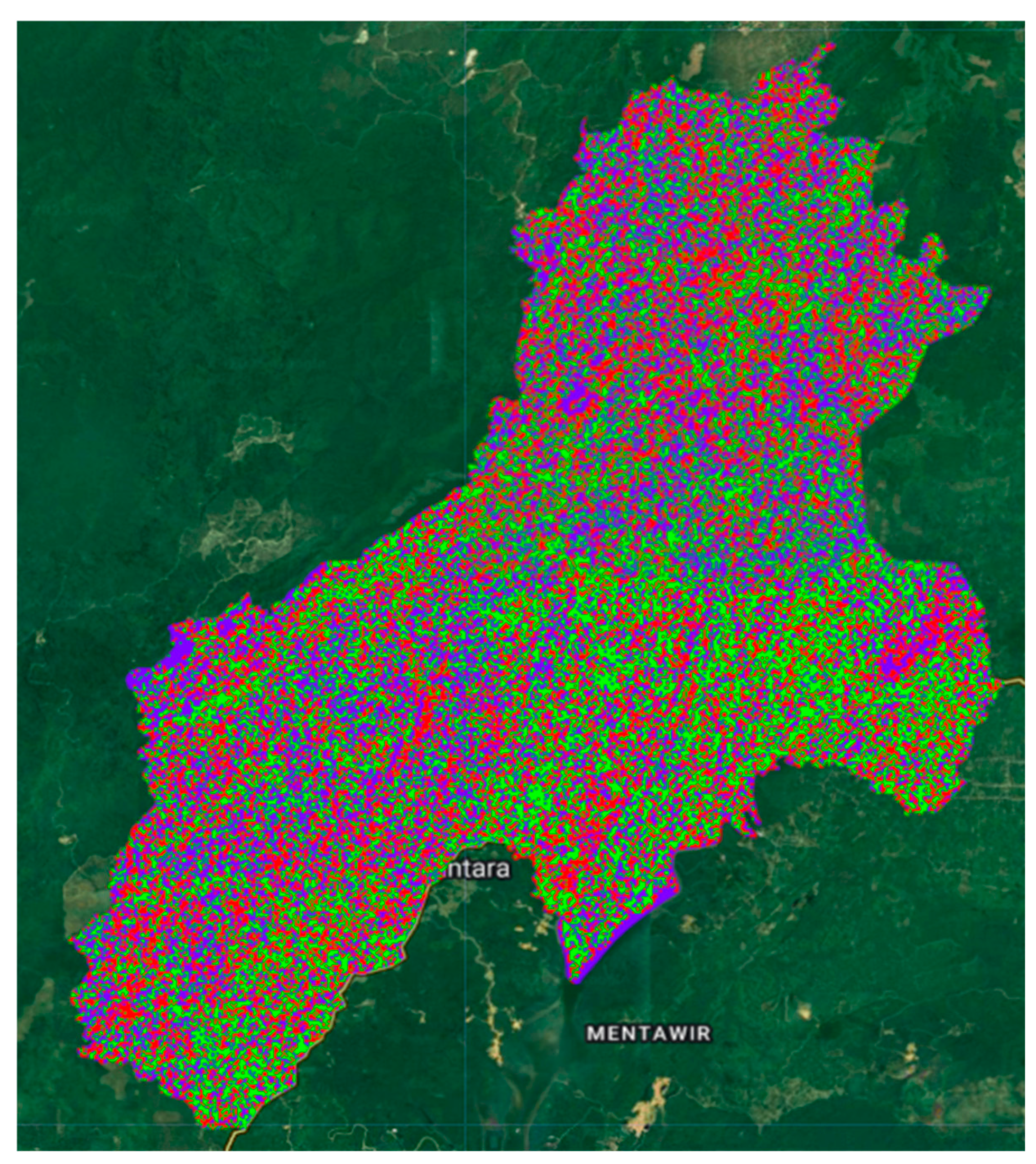
Figure 2.
Training Points.
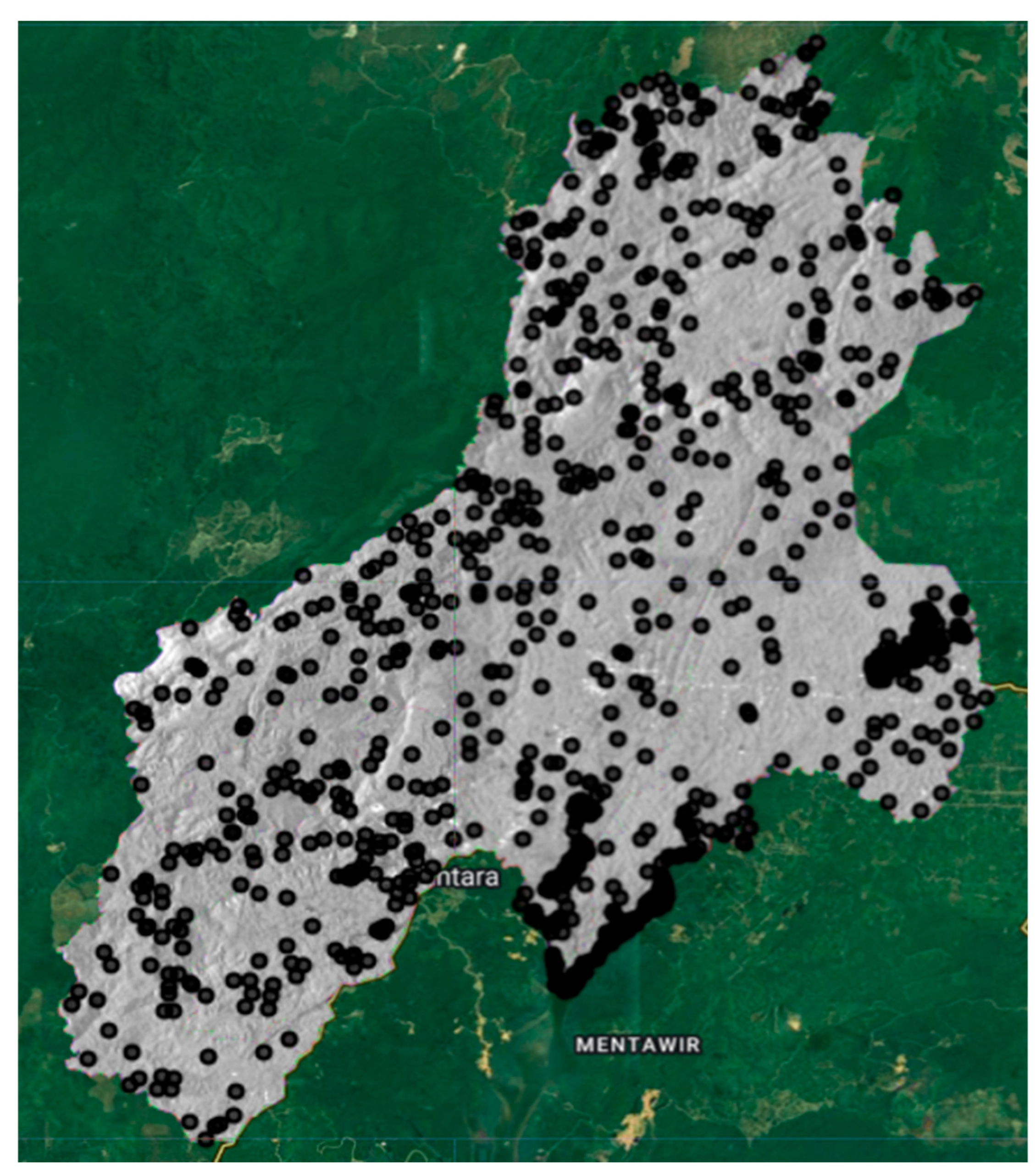
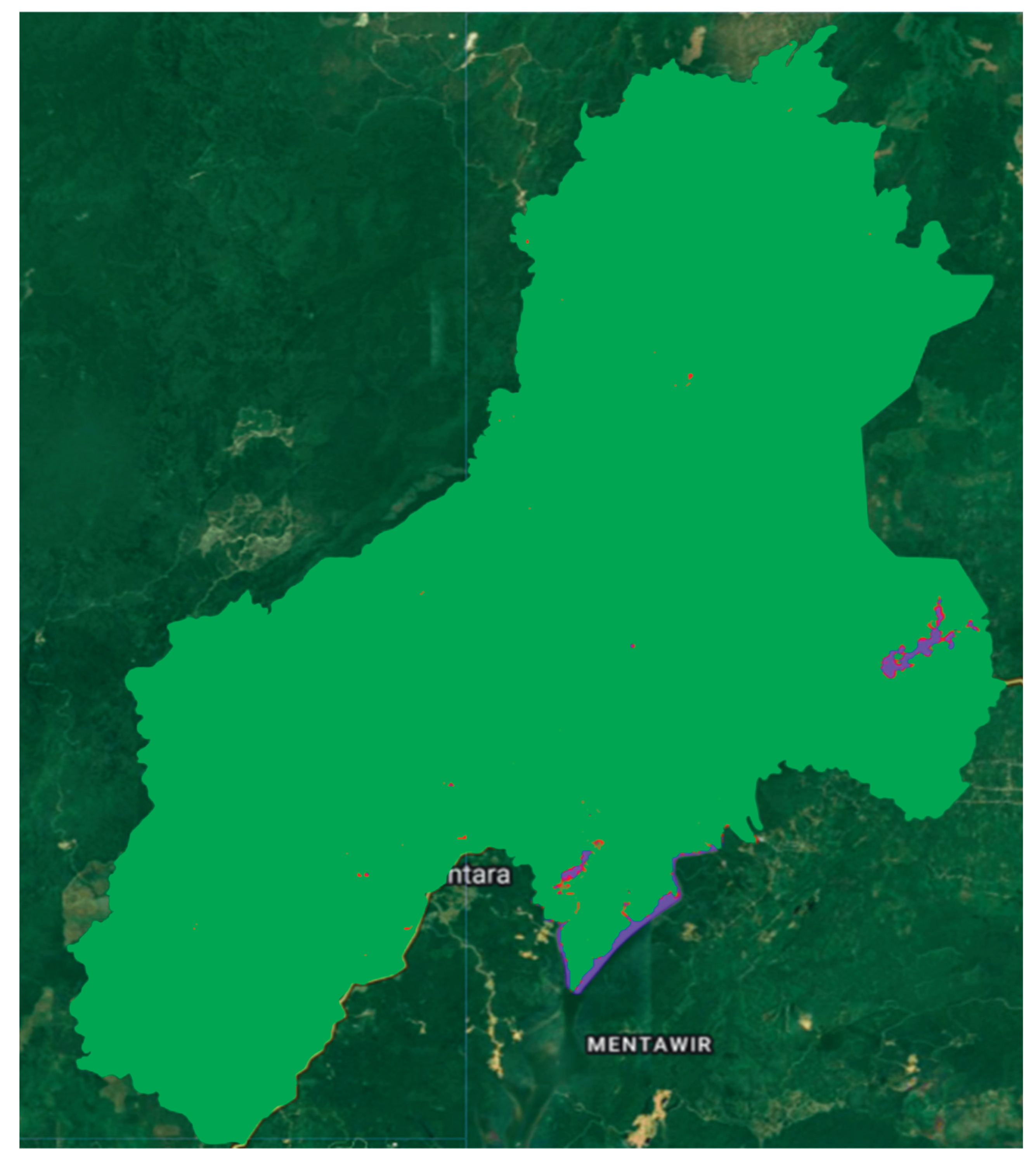
Figure 3.
CNN-Based Land Cover Classification.
b. Training Points
The spatial distribution of training points (displayed in black) used in the Random Forest classification is shown in Figure 2. Each point represents a labeled sample derived from field observations, satellite image interpretation, or reference data sources. These training points were essential for teaching the model how to recognize the spectral characteristics of each land cover class (e.g., vegetation, bare land, settlement, water). The wide and evenly distributed placement of training points across the study area demonstrates an effort to build a representative model. Diverse point locations help avoid classification bias and ensure robust performance across various topographic and lighting conditions. However, the ideal number and distribution depend on landscape complexity and the quality of available reference data. These training points are critical components in the development of machine learning–based land cover classification models. The accuracy and representativeness of training data significantly influence classification outcomes. Ongoing validation and refinement of training datasets are recommended, especially in visually heterogeneous or spectrally ambiguous areas.
c. CNN-Based Land Cover Classification
The CNN-based land cover classification maps show the predicted land cover distribution in the IKN region. The dominance of bright green areas indicates extensive forest or vegetation coverage, consistent with IKN’s natural characteristics. Scattered red, purple, and other colored regions represent non-vegetated classes such as open land, water bodies, and built-up zones. Compared to traditional classifiers such as Random Forest, the CNN approach demonstrates higher sensitivity to spatial and textural variations, successfully detecting small features and class boundaries. For instance, irregular spatial patterns along the southeastern boundary and near Mentawir were identified with fine detail. However, signs of overfitting were also observed, suggesting that the model may have learned patterns too closely from training data, affecting generalization. Overall, the CNN classification demonstrates strong performance in detecting major land cover classes in the study area. However, accuracy validation using confusion matrices and cross-validation against reference data remains crucial. Direct comparisons with alternative classifiers (e.g., Random Forest or SVM) can provide further insight into the CNN model’s reliability.
4.2. Planning Implications
The spatial predictions generated by the GeoAI model offer strategic insights for urban planning and development in Nusantara Capital (IKN). With the ability to dynamically forecast land cover change, urban planners can better anticipate development pressures on ecologically sensitive zones such as watersheds, protected forests, and green buffer areas an essential consideration for IKN’s sustainability mandate. The predicted expansion of built-up areas indicates the urgent need for tighter land use regulation and early-warning spatial systems. GeoAI’s predictive heatmaps can be instrumental in identifying high-pressure zones before actual conversion occurs. These insights support more responsive and evidence-based revisions to spatial plans (RTRWs). The predictive maps also guide infrastructure development strategies. Knowing where future development is likely to occur enables planners to align transport networks, water systems, and energy distribution more efficiently. This reduces the risk of spatial mismatches between infrastructure provision and settlement growth an issue common in new urban developments.
In the context of long-term land use planning, GeoAI enables flexible planning frameworks that adapt to socio-economic and environmental dynamics. Predictive outputs allow policymakers and developers to design anticipatory urban growth scenarios and establish transition zones that mediate between conservation and development. From a policy standpoint, GeoAI models serve as valuable tools in land use permitting, zoning enforcement, and real-time spatial monitoring. Visualization through heatmaps enables targeted interventions and supports dynamic zoning regulations. These predictive, data-driven approaches are highly relevant for a rapidly evolving city like IKN. GeoAI can also facilitate smart governance initiatives through open data and real-time spatial dashboards. Citizen participation can be encouraged via interactive platforms that allow communities to report unauthorized land changes or provide input on planning initiatives fostering a transparent, adaptive, and community-informed planning system.
In sum, the GeoAI model’s outputs are not just technically valuable; they have strategic significance in realizing IKN’s vision of a smart, sustainable, and participatory city. The spatial predictions support planning decisions that balance ecological preservation with data-informed urban development.
The CNN Model Confusion Matrix table shows that the CNN model successfully classified all test pixels into their appropriate classes. This matrix consists of three main classes: Water, Vegetation, and Built-up, with the following results:
- Water Class: 88 pixels were correctly classified as Water.
- Vegetation Class: 90 pixels were correctly classified as Vegetation.
- Built-up Class: 95 pixels were correctly classified as Built-up.
There were no misclassifications between classes (off-diagonal value = 0), resulting in an overall accuracy of 1.0 or 100%. This indicates that the CNN model is very good at recognizing the spectral characteristics of each class in the dataset used.
The Confusion Matrix Comparison Table between CNN and Random Forest was used to evaluate the classification accuracy of three land cover classes: Water, Vegetation, and Built-up. The CNN results showed perfect classification with 100% accuracy, where all predictions matched the reference class correctly without error (full diagonal value). This demonstrates the very high potential of CNN in detecting spatial patterns, although it is still necessary to be aware of the possibility of overfitting or a limited number of test samples. This comparison is important to assess which model is more reliable in land mapping, so that it can be used as a basis for selecting the best approach for further analysis.
5. Conclusions and Recommendations
5.1. Conclusions
This study demonstrates the significant potential of Geospatial Artificial Intelligence (GeoAI) particularly through the integration of Convolutional Neural Networks (CNN) and the Google Earth Engine (GEE) to support smart urban planning in Indonesia. Using the case of Nusantara Capital (IKN), the research presents a practical application of spatial prediction modeling to generate early insights into future urban expansion, land cover dynamics, and ecological pressures. The spatial prediction results reveal a strong trend of built-up area growth that is encroaching upon buffer zones and natural green areas. These findings highlight the urgent need for an adaptive and predictive spatial monitoring system. GeoAI adds value by enabling rapid, scalable, and real-time multitemporal data analysis capabilities that are difficult to achieve with conventional planning methods.
Beyond its technical merits, the study emphasizes the importance of integrating GeoAI outputs into formal spatial policies and planning systems. The impact of this technology will only be realized when supported by institutional frameworks that promote participatory and evidence-based planning. GeoAI can serve as a policy-support tool within a dynamic, data-driven spatial planning process. Nonetheless, several challenges remain. These include limitations in high-resolution data availability, human resource capacity, and institutional readiness for technology adoption. The CNN model is also sensitive to the quality of training and validation data, emphasizing the need for robust labeling methods and consistent data input. In conclusion, GeoAI represents an innovative and promising approach to address the complex planning challenges in IKN. However, its success hinges on strong synergy between technology, data governance, and inclusive policy frameworks. This study contributes a foundational model for bridging the gap between AI-based spatial modeling and the needs of future-oriented urban development in Indonesia.
5.2. Recommendations
Integration of GeoAI into Spatial Planning Policies
The central government and the IKN Authority should consider integrating GeoAI systems into the evaluation and revision processes of spatial plans (RTRWs) and development permits. This can be achieved through partnerships with research institutions and universities to build a sustainable predictive planning ecosystem.
Improvement of Spatial Data Access and Quality
Access to high-resolution satellite imagery and supporting datasets (e.g., digital elevation models, land use records, socioeconomic layers) must be expanded. National open data policies should be promoted to support broader GeoAI development efforts.
Development of Public Monitoring Dashboards
A web-based spatial visualization platform should be developed to make GeoAI outputs accessible to the public and stakeholders. Such dashboards can enhance transparency and facilitate public participation in spatial planning processes.
Capacity Building for Local Human Resources
Targeted training and certification programs for urban planners, GIS analysts, and local government officials are essential for the independent operation of GeoAI systems. A national curriculum or training initiative focused on GeoAI should be implemented.
Extension of Case Studies and Replication
Future research could include additional predictive variables such as population growth, traffic flow, and climate change impacts. The proposed GeoAI approach can also be replicated in other rapidly growing cities or strategic zones such as special economic areas (SEZs) in Kalimantan, Sulawesi, or Papua.
Ethical and Spatial Justice Considerations
AI-based predictive models must be evaluated for potential social and ethical impacts, particularly concerning indigenous communities, vulnerable groups, and the equitable distribution of spatial resources. GeoAI systems should be developed with spatial justice as a core principle.
References
- Amani, M., Ghorbanian, A., Ahmadi, S. A., Kakooei, M., Moghimi, A., Mirmazloumi, S. M., Moghaddam, S. H. A., Mahdavi, S., Ghahremanloo, M., Parsian, S., Wu, Q., & Brisco, B. (2020). Google Earth Engine Cloud Computing Platform for Remote Sensing Big Data Applications: A Comprehensive Review. IEEE Journal of Selected Topics in Applied Earth Observations and Remote Sensing, 13, 5326–5350. [CrossRef]
- Arfiansyah, D., Han, H., & Zlatanova, S. (2024). Land Suitability Analysis for Residential Development in an Ecologically Sensitive Area: A Case Study of Nusantara, the New Indonesian Capital. Sustainability, 16(13), 5767. [CrossRef]
- Bhattacharjee, S., Sharma, N., Salim, M., Garg, R. D., & Sharma, K. (2025). Predictive modeling of land cover changes in round-1 smart cities of India using cellular automata and GIS. Discover Cities, 2(1). [CrossRef]
- Caprari, G., Castelli, G., Montuori, M., Camardelli, M., & Malvezzi, R. (2022). Digital Twin for Urban Planning in the Green Deal Era: A State of the Art and Future Perspectives. Sustainability, 14(10), 6263. [CrossRef]
- Carranza-García, M., García-Gutiérrez, J., & Riquelme, J. C. (2019). A Framework for Evaluating Land Use and Land Cover Classification Using Convolutional Neural Networks. Remote Sensing, 11(3), 274. [CrossRef]
- Chen, S., Zhang, M., & Lei, F. (2023). Mapping Vegetation Types by Different Fully Convolutional Neural Network Structures with Inadequate Training Labels in Complex Landscape Urban Areas. Forests, 14(9), 1788. [CrossRef]
- Choi, Y. (2023). GeoAI: Integration of Artificial Intelligence, Machine Learning, and Deep Learning with GIS. Applied Sciences, 13(6), 3895. [CrossRef]
- Demissie, B., Vanhuysse, S., Grippa, T., Flasse, C., & Wolff, E. (2023). Using Sentinel-1 and Google Earth Engine cloud computing for detecting historical flood hazards in tropical urban regions: A case of Dar es Salaam. Geomatics, Natural Hazards and Risk, 14(1). [CrossRef]
- Fauzi, C. (t.t.). A REVIEW GEOSPATIAL ARTIFICIAL INTELLIGENCE (GEO-AI): IMPLEMENTATION OF MACHINE LEARNING ON URBAN PLANNING. Urban Planning.
- Fayaz, M., Nam, J., Dang, L. M., Song, H.-K., & Moon, H. (2024). Land-Cover Classification Using Deep Learning with High-Resolution Remote-Sensing Imagery. Applied Sciences, 14(5), 1844. [CrossRef]
- Feng, Q., Yang, J., Zhu, D., Liu, J., Guo, H., Bayartungalag, B., & Li, B. (t.t.). Integrating Multitemporal Sentinel-1/2 Data for Coastal Land Cover Classification Using a Multibranch Convolutional Neural Network: A Case of the Yellow River Delta.
- Gharahbagh, A. A., Hajihashemi, V., Machado, J. J. M., & Tavares, J. M. R. S. (2025). Land Cover Classification Model Using Multispectral Satellite Images Based on a Deep Learning Synergistic Semantic Segmentation Network. Sensors, 25(7), 1988. [CrossRef]
- Gómez, J. A., Patiño, J. E., Duque, J. C., & Passos, S. (2019). Spatiotemporal Modeling of Urban Growth Using Machine Learning. Remote Sensing, 12(1), 109. [CrossRef]
- Hu, W., Chen, T., Lan, C., Liu, S., & Yin, L. (2024). SkipResNet: Crop and Weed Recognition Based on the Improved ResNet. Land, 13(10), 1585. [CrossRef]
- Kasahun, M., & Legesse, A. (2024). Machine learning for urban land use/ cover mapping: Comparison of artificial neural network, random forest and support vector machine, a case study of Dilla town. Heliyon, 10(20), e39146. [CrossRef]
- Kunwar, S., & Ferdush, J. (2023). Mapping of Land Use and Land Cover (LULC) using EuroSAT and Transfer Learning (No. arXiv:2401.02424). arXiv. arXiv:2401.02424). arXiv. [CrossRef]
- Li, Z., & Dong, J. (2022). A Framework Integrating DeeplabV3+, Transfer Learning, Active Learning, and Incremental Learning for Mapping Building Footprints. Remote Sensing, 14(19), 4738. [CrossRef]
- Liu, J., Xiao, B., Li, Y., Wang, X., Bie, Q., & Jiao, J. (2021). Simulation of Dynamic Urban Expansion under Ecological Constraints Using a Long Short Term Memory Network Model and Cellular Automata. Remote Sensing, 13(8), 1499. [CrossRef]
- Liu, P., & Biljecki, F. (2022). A review of spatially-explicit GeoAI applications in Urban Geography. International Journal of Applied Earth Observation and Geoinformation, 112, 102936. [CrossRef]
- Liu, X., Shan, Y., Ai, G., Du, Z., Shen, A., & Lei, N. (2024). A Scientific Investigation of the Shangfang Mountain Yunshui Cave in Beijing Based on LiDAR Technology. Land, 13(6), 895. [CrossRef]
- Mazzia, V., Khaliq, A., & Chiaberge, M. (2019). Improvement in Land Cover and Crop Classification based on Temporal Features Learning from Sentinel-2 Data Using Recurrent-Convolutional Neural Network (R-CNN). Applied Sciences, 10(1), 238. [CrossRef]
- Mortaheb, R., & Jankowski, P. (2023). Smart city re-imagined: City planning and GeoAI in the age of big data. Journal of Urban Management, 12(1), 4–15. [CrossRef]
- Mostafa, E., Li, X., Sadek, M., & Dossou, J. F. (2021). Monitoring and Forecasting of Urban Expansion Using Machine Learning-Based Techniques and Remotely Sensed Data: A Case Study of Gharbia Governorate, Egypt. Remote Sensing, 13(22), 4498. [CrossRef]
- Mutale, B., Withanage, N. C., Mishra, P. K., Shen, J., Abdelrahman, K., & Fnais, M. S. (2024). A performance evaluation of random forest, artificial neural network, and support vector machine learning algorithms to predict spatio-temporal land use-land cover dynamics: A case from lusaka and colombo. Frontiers in Environmental Science, 12. [CrossRef]
- Naushad, R., Kaur, T., & Ghaderpour, E. (2021). Deep Transfer Learning for Land Use and Land Cover Classification: A Comparative Study. Sensors, 21(23), 8083. [CrossRef]
- Ouchra, H., Belangour, A., & Erraissi, A. (2023). Machine Learning Algorithms for Satellite Image Classification Using Google Earth Engine and Landsat Satellite Data: Morocco Case Study. IEEE Access, 11, 71127–71142. [CrossRef]
- Pluto-Kossakowska, J., Fijałkowska, A., Denis, M., Jaroszewicz, J., & Krzysztofowicz, S. (2022). Dashboard as a Platform for Community Engagement in a City Development—A Review of Techniques, Tools and Methods. Sustainability, 14(17), 10809. [CrossRef]
- Pradana, R. P., Bhanage, V., Fajary, F. R., Hussainzada, W., Badriana, M. R., Lee, H. S., Kubota, T., Nimiya, H., & Putra, I. D. G. A. (2025). Assessing Green Strategies for Urban Cooling in the Development of Nusantara Capital City, Indonesia. Climate, 13(2), 30. [CrossRef]
- Ranatunga, S., Ødegård, R. S., Onstein, E., & Jetlund, K. (2024). Digital Twins for Geospatial Decision-making. ISPRS Annals of the Photogrammetry, Remote Sensing and Spatial Information Sciences, X-4–2024, 271–278. [CrossRef]
- Rodrigues, J., Dias, M. A., Negri, R., Hussain, S. M., & Casaca, W. (2024). A Robust Dual-Mode Machine Learning Framework for Classifying Deforestation Patterns in Amazon Native Lands. Land, 13(9), 1427. [CrossRef]
- Sangeetham, R., & Reddy S, N. (2024). A Review On Google Earth Engine: An Open Access Cloud Analysis Platform For Planetary Scale Satellite Data. E3S Web of Conferences, 591, 09011. [CrossRef]
- Shimamura, T., & Mizunoya, T. (2020). Sustainability Prediction Model for Capital City Relocation in Indonesia Based on Inclusive Wealth and System Dynamics. Sustainability, 12(10), 4336. [CrossRef]
- Syaban, A. S. N., & Appiah-Opoku, S. (2024). Unveiling the Complexities of Land Use Transition in Indonesia’s New Capital City IKN Nusantara: A Multidimensional Conflict Analysis. Land, 13(5), 606. [CrossRef]
- Teo, H. C., Lechner, A. M., Sagala, S., & Campos-Arceiz, A. (2020). Environmental Impacts of Planned Capitals and Lessons for Indonesia’s New Capital. Land, 9(11), 438. [CrossRef]
- Tesfaye, W., Elias, E., Warkineh, B., Tekalign, M., & Abebe, G. (2024). Modeling of land use and land cover changes using google earth engine and machine learning approach: Implications for landscape management. Environmental Systems Research, 13(1). [CrossRef]
- Vali, A., Comai, S., & Matteucci, M. (2020). Deep Learning for Land Use and Land Cover Classification Based on Hyperspectral and Multispectral Earth Observation Data: A Review. Remote Sensing, 12(15), 2495. [CrossRef]
- Verde, N., Patias, P., & Mallinis, G. (2022). A Cloud-Based Mapping Approach Using Deep Learning and Very-High Spatial Resolution Earth Observation Data to Facilitate the SDG 11.7.1 Indicator Computation. Remote Sensing, 14(4), 1011. [CrossRef]
- Xiao, L., Wu, M., Weng, Q., & Li, Y. (2025). Unraveling Street Configuration Impacts on Urban Vibrancy: A GeoXAI Approach. Land, 14(7), 1422. [CrossRef]
- Yang, L., Driscol, J., Sarigai, S., Wu, Q., Chen, H., & Lippitt, C. D. (2022). Google Earth Engine and Artificial Intelligence (AI): A Comprehensive Review. Remote Sensing, 14(14), 3253. [CrossRef]
- Yao, Y., Liu, X., Zhang, D., Liang, Z., Zhang, Y., Yao, Y., Liu, X., & Zhang, D. (t.t.). Simulation of Urban Expansion and Farmland Loss in China by Integrating Cellular Automata and Random Forest.
- Zhao, S., Tu, K., Ye, S., Tang, H., Hu, Y., & Xie, C. (2023). Land Use and Land Cover Classification Meets Deep Learning: A Review. Sensors, 23(21), 8966. [CrossRef]
- Zhou, K., Ming, D., Lv, X., Fang, J., & Wang, M. (2019). CNN-Based Land Cover Classification Combining Stratified Segmentation and Fusion of Point Cloud and Very High-Spatial Resolution Remote Sensing Image Data. Remote Sensing, 11(17), 2065. [CrossRef]

Table 1.
Confusion Matrix – Model CNN.
| Reference Class / Classification | Water (0) | Vegetation (1) | Built-up (2) | Total |
|---|---|---|---|---|
| Water | 88 | 0 | 0 | 88 |
| Vegetation | 0 | 90 | 0 | 90 |
| Built-up | 0 | 0 | 95 | 95 |
| total | 88 | 90 | 95 | 273 |
Table 2.
Confusion Matrix Comparison: CNN vs Random Forest.
| Clas | CNN (Prediction) | Random Forest (Prediction) | ||||||
|---|---|---|---|---|---|---|---|---|
| Referensce | Water | Vegetation | Built-up | Total | Air | Vegetation | Built-up | Total |
| Water | 88 | 0 | 0 | 88 | X | Y | Z | - |
| Vegetation | 0 | 90 | 0 | 90 | A | B | C | - |
| Built-up | 0 | 0 | 95 | 95 | D | E | F | - |
| total | 88 | 90 | 95 | 273 | - | - | - | - |
Disclaimer/Publisher’s Note: The statements, opinions and data contained in all publications are solely those of the individual author(s) and contributor(s) and not of MDPI and/or the editor(s). MDPI and/or the editor(s) disclaim responsibility for any injury to people or property resulting from any ideas, methods, instructions or products referred to in the content. |
© 2025 by the authors. Licensee MDPI, Basel, Switzerland. This article is an open access article distributed under the terms and conditions of the Creative Commons Attribution (CC BY) license (http://creativecommons.org/licenses/by/4.0/).
Copyright: This open access article is published under a Creative Commons CC BY 4.0 license, which permit the free download, distribution, and reuse, provided that the author and preprint are cited in any reuse.


