Submitted:
16 July 2025
Posted:
17 July 2025
You are already at the latest version
Abstract
The paper is devoted to the application of artificial intelligence (AI) in the mining industry, geology and environmental safety. Artificial intelligence offers revolutionary approaches to overcoming these challenges. This article systematizes modern areas of AI application at various stages of geological exploration (GE) - from forecasting and prospecting to assessment and exploration of solid mineral deposits (SMD). Key technologies, successful implementation cases, advantages, limitations and prospects for the development of AI in the mineral resources complex are considered. The Digital Caspian information platform is described, combining the power of artificial intelli-gence, geographic information systems and digital twins. Its goal is to revolutionize approaches to subsoil use, ensure environmental safety and optimize strategic planning of geological exploration. The introduction of artificial intelligence into the basis of the "Digital Caspian" allows us to form an intelligent geological exploration system - a complex of software and hardware that can transform the management of geological exploration processes, bringing them to a qualitatively new level of efficiency and ac-curacy. For this purpose, it is proposed to use digital engineering, the essence of which is the creation of a virtual prototype of a real object - a mineral deposit and the geological exploration process in general. The core of the platform is a series of interactive geo-logical and environmental digital maps that allow us to accurately predict changes and make balanced, scientifically sound decisions in key areas of subsoil use, environmental safety and plan geological exploration work.
Keywords:
artificial intelligence
; machine learning
; geological exploration
; solid minerals
; geodata processing
; minerageny
; digital geology
; geoinformation systems
; digital twins
; ecology
1. Introduction
Traditional methods of geological exploration for solid minerals are facing increasing difficulties: depletion of easily detectable deposits, increasing depth of occurrence of objects, the need to process huge volumes of heterogeneous data and high costs. Search and exploration of new deposits of solid minerals is a fundamental task for ensuring mineral resource security. Traditional approaches based on expert interpretation of geological, geophysical and geochemical data are becoming less effective and economically justified when working with complex, hidden or deep-seated objects. There is an urgent need for new tools that are capable of: processing exponentially growing volumes of heterogeneous data (Big Data); using the results of numerical modeling that recreate the conditions of formation of solid mineral deposits (Figure 1); identifying complex patterns and relationships that are not obvious to humans; increasing the accuracy of forecast models and reducing the risk of errors; optimize exploration costs. Artificial intelligence, which has the potential to solve these problems, is being actively introduced into exploration practice, forming a new paradigm - "digital geological exploration".
The purpose of this development was to create a digital platform, the Digital Caspian, an innovative tool designed to transform the approach to the study and development of the subsoil of the Caspian region. The core of the platform is a series of interactive geological and environmental digital maps that allow for highly accurate prediction of changes and informed, scientifically based decisions in key areas of subsoil use, environmental safety, and planning of geological exploration [5]. The interactive digital platform, the Digital Caspian, is not just a database, but a repository of geological, geophysical, and geochemical information enriched with the results of numerical modeling that recreate the geological and environmental conditions of the Caspian region. The platform allows for comprehensive monitoring of the ecosystem: tracking pollution, predicting degradation, and assessing the destructive impact of oil and gas production on fragile biodiversity [6].
The relevance of the study is due to the strategic importance of the Caspian region for the development of mineral resources in Russia. This unique region, which holds colossal reserves of mineral resources in its depths and has fragile, unique ecosystems, requires a balanced and scientifically sound approach to geological exploration. For the first time, an innovative information platform "Digital Caspian" and a series of interactive geological and environmental digital maps have been created to solve this problem.
2. Methods
The main areas of application of artificial intelligence in the geological exploration process for solid minerals are:
Predictive mapping and identification of promising areas
- Analysis of multidimensional geological data: ML algorithms (SVM - support vector machines, Random Forest, Gradient Boosting analyze a set of data (geology, tectonics, geochemistry, geophysics, remote sensing) to build mineral potential maps and forecast and exploration models. AI reveals hidden patterns linking known deposits with the geological environment and extrapolates them to new territories;
- Integration of Earth observation data: Convolutional neural networks (CNN) efficiently process satellite and aerial images to: Automatically recognize lineaments, ring structures, zones of altered rocks (silicification, listvenization, etc.) associated with mineralization; Identify spectral anomalies indicating the presence of certain minerals; Classify lithology and structures.
Interpretation of geophysical data
- Automatic processing and filtering: Deep learning algorithms (autoencoders) effectively suppress noise in geophysical data (magnetic, gravity, electrical exploration), highlighting useful signals;
- Anomaly recognition and classification: CNN and other neural network architectures automatically highlight and classify anomalies potentially associated with ore bodies on magnetic and gravity field maps, geoelectric sections;
- 3D inversion and modeling: ML and deep learning methods significantly accelerate and improve the accuracy of solving inverse problems of geophysics, building realistic 3D models of the geological environment based on geophysical data. Deep learning is used for nonlinear inversion.
Geochemical data analysis
- Geochemical anomaly detection: Algorithms (k-means, DBSCAN, anomaly detection methods such as Isolation Forest) allow for objective identification of significant geochemical anomalies against regional variations, minimizing subjectivity;
- Prediction of mineralization types: Classification models (SVM, Random Forest, neural networks) based on multi-element geochemical spectra predict the probability of detecting certain types of deposits (porphyry copper, gold-quartz, etc.) and identify primary dispersion halos.
Processing and interpretation of drilling and core data
- Automatic lithology partitioning: LSTM (long short-term memory, CNN) algorithms analyze log data (GR, PS, NNCT, resistivity, etc.) and core images to automatically identify lithologic boundaries and rock types along the borehole;
- Core image analysis: CNNs process core photos and scans to: Recognize and quantify minerals; Identify textures and structures; Assess fractures and porosity; Detect signs of mineralization;
- Exploration program optimization: Optimization algorithms (ML-based or heuristic) help plan optimal well networks to achieve exploration goals at minimal cost.
Data integration and construction of complex 3D geological models
- Synthesis of heterogeneous information: AI systems (often based on Bayesian networks or deep learning) integrate geology, geophysics, geochemistry, drilling, remote sensing data into a single consistent 3D geological model of a deposit or area;
- Prediction of block model parameters: Algorithms (Geostatistical ML, Random Forest for regression) are used to spatially predict the grades of useful components, density, lithology and other parameters in resource model blocks, increasing the accuracy of reserve estimates.
The Digital Caspian is a large-scale project that combines the power of artificial intelligence, geographic information systems and digital twins. To develop the Digital Caspian digital platform, a block diagram (Figure 2) and an interactive database (IDB) (Figure 3) were created to form the basis for interactive geological and environmental digital maps that open up new horizons for comprehensive analysis, forecasting and scientifically based decision-making. Its goal is to revolutionize approaches to subsoil use, ensure environmental safety and optimize strategic planning of geological exploration [7,8,9].
The platform integrates: Digital twins of geological systems, ecosystems and regional infrastructure; Multidimensional geological and ecological models, as well as models of mineral deposits; AI models for forecasting solid minerals, environmental threats and economic scenarios; GIS systems for analyzing geological data, integrating cartographic information and visualizing results; Decision-making tools with support for automated recommendations. A significant advantage of the IDB compared to traditional geoinformation databases is the ability to visualize its contents without the use of special software (SW), which allows a wide range of specialists to use the collected and systematized geological information, including those who do not have the skills to work with specific special software and/or do not have the appropriate licenses [10,11,12].
Digital maps are an interactive database (IDB) of geological, geophysical and geochemical information and are intended to visualize the content of geoinformation databases in accordance with the approved structure, which is determined by the tasks of geological exploration and the results of the numerical modeling performed [13,14,15]. The platform is a comprehensive digital platform designed for modeling, forecasting and decision support in geological exploration. In the mining industry, numerical models are used to solve various problems:
- Planning of mining operations. Models allow to define quarry boundaries, calculate production capacity and term of reserves development;
- Analysis of stress-strain state of rock mass. Models allow to take into account the influence of mining operations on the state of the massif, to determine stable parameters of workings and chambers;
- Modeling and optimization of special methods of driving. With the help of numerical models, the efficiency of artificial freezing of rocks or chemical preliminary consolidation is studied.
The above approaches were used in developing the structure of the Digital Caspian IDB. In accordance with the tasks set, it includes the following blocks: “Structural framework”, “Signs of solid mineral manifestations”, “Paleogeography”, “Ecology”, “Boundary conditions”, “Modeling results” (Figure 3). The blocks contain materials that make up a set of input data for modeling, including primary information and the results of its interpretation – the results of numerical modeling, and the eighth – calibration data [16,17].
As a result, three-dimensional and two-dimensional models developed as a result of numerical modeling, recreating geological and environmental conditions, were transformed into interactive geological and environmental digital maps (see Figure 6). The full cycle of transforming models into maps includes: 1. Preparation and systematization of input data in QGIS → 2. Digitization of maps in QGIS → 3. Construction of 3D grids → 4. Calculation of 3D geological model → 5. Analysis of the obtained results in QGIS → 6. Creation of an interactive database in the Python programming language with the involvement of artificial intelligence, including the development of a web interface, integration of resulting maps, graphs, sections, borehole and calibration data, implementation of analysis tools and systematization with the involvement of AI [18,19,20].
3. Results
The result of the work was the birth of the innovative digital platform "Digital Caspian" - combining analytical modules designed to study the geological conditions of the formation and distribution of mineral resources, the ecological and geoeconomic state of the region. The system allows you to look into the future of the Caspian, predicting changes in sea level, temperature and salinity, relying on the power of global climate models. Modeling climate change opens a window into the coming decades, allowing you to prepare for the challenges of the time. Using the power of neural networks (LSTM, Transformers), the system generates probabilistic scenarios, opening the way to forecasting crisis situations and environmental disasters, such as oil spills and droughts [21,22,23].
These tools are designed to provide comprehensive analysis, accurate forecasting and adoption of verified, scientifically based decisions in the field of subsoil use, environmental safety and long-term planning of geological exploration activities [24,25,26]. The multidisciplinary nature and exceptional relevance of the work become especially obvious in the context of increasing anthropogenic pressure and transboundary environmental risks [27,28,29]. In this regard, the formation of digital tools capable of providing comprehensive monitoring, scenario modeling and support for environmentally responsible decisions is of paramount importance. The introduction of AI allows the creation of an intelligent geological exploration system. “Smart Geological Exploration” is a set of software and hardware that combines digital technologies and engineering knowledge to optimize and transform production and logistics processes, which allows managing the process of geological exploration and development of mineral deposits, including all stages of the life cycle of mineral deposits (Figure 4).
Figure 5 and Figure 6 show, as an example, digital structural-spatial models of the Black Sea-Caspian region generated in the digital platform. Three-dimensional and two-dimensional models developed as a result of numerical modeling, recreating geological and environmental conditions, were transformed into interactive geological and environmental digital maps (Figure 7).
The introduction of artificial intelligence (AI) technologies contributes to the exponential growth of the number of artificial neural network models and their specialization for solving various target problems - planning and optimization of the geological exploration process [30,31,32]. To solve the tasks, it is necessary to use engineering-oriented strong artificial intelligence technologies that do not require routine human participation, consisting of human-centric and machine-centric systems [33,34,35]. As part of the introduction of AI to improve the efficiency and optimize the geological exploration process, digital twins and digital maps were created. Several thousand numerical models were generated in the digital platform, recreating geological and environmental conditions, as well as models of minerals of the Caspian region.
4. Conclusions
Among the most significant results are:
• A flexible platform architecture was designed and implemented, the foundation of which was modularity, scalability and seamless integration with external data sources and existing industry IT solutions.
• An intelligent geological exploration system was created as a result of the introduction of AI - a set of software and hardware that combines digital technologies and engineering knowledge to optimize and transform production and logistics processes, which allows managing the process of geological exploration and development of mineral deposits.
• Detailed digital twins of geological and ecological systems of the Caspian region were created. These virtual models, including three-dimensional reconstructions of deposits, structural complexes and zones of environmental stress, allow us to look into the very core of natural processes.
• Advanced forecasting algorithms based on machine learning were implemented, including LSTM and Transformer neural network architectures, capable of predicting future changes.
• Interactive maps of the ecological state have been developed, providing the ability to visualize data in space and time. These tools open the way to deep scientific interpretation and provide access to information for a wide range of users - from researchers to decision makers.
• The platform has been tested on real cases covering areas of active resource extraction, biologically vulnerable areas and regions of strategic geoeconomic importance in the Caspian Basin.
• A complete set of user and methodological documentation has been prepared, guaranteeing the reproducibility of scientific experiments and providing the ability to scale the platform for use in other regions of the world.
Artificial intelligence does not replace fundamental geological knowledge and experience, but it is becoming a powerful tool in the arsenal of a modern exploration geologist. It allows you to process previously unimaginable volumes of information, identify hidden patterns, significantly increase the efficiency and accuracy of forecasts, reduce risks and costs. The synergy of geologist expertise and AI analytical power opens a new era in solid mineral exploration and prospecting, which is necessary to meet the growing global demand for mineral resources. Further research should be aimed at overcoming existing limitations, especially in the area of model interpretability and working with incomplete data, as well as developing standardized industry solutions.
The scientific novelty of the presented results lies in the innovative integrated approach to digital modeling, which allows for simultaneous consideration of geological, environmental and man-made factors. The Digital Caspian platform is a unique tool for transdisciplinary research, deep scientific analysis and sustainable resource management. The platform can be easily adapted to other regions of Russia.
Abbreviations
The following abbreviations are used in this manuscript:
| AI | Artificial intelligence |
| GIS | Geographic information systems |
| GE | Geological exploration |
| SMD | Solid mineral deposits |
| SVM | Support vector machines |
| CNN | Convolutional neural networks |
| IDB | Interactive database |
References
- Marakova, I.A. (2024). Method for increasing the efficiency of exploration work in complex zones of the Timan-Pechora province based on solving inverse problems of geophysics.
- Zakrevsky, K.E. (2009). Geological 3D modeling, OOO IPC Maska, Moscow, 376 p.
- Malivanov, S.Yu. Integrated modeling environment now covers geological and geoecological areas of development [Electronic resource] https://ardexpert.ru/article/12712 (date of access 06/05/2025).
- Stadnik, D.A. , Gabaraev O.Z., Stadnik N.M., Grigoryan K.L. (2020). Improving the quality of digital "doubles" of mining enterprises based on the standardization of the attributive content of technological 3D models in GGIS // Mining Information and Analytical Bulletin. pp. 202-212. [CrossRef]
- Roadmap for the development of "end-to-end" digital technology " (2019). Neurotechnology and artificial intelligence" // Ministry of Digital Development, Communications and Mass Media of the Russian Federation.
- Dmitrievsky, A.N., Eremin, N.A., Filippova, D.S., & Safarova, E.A. (2020). The digital oil and gas complex of Russia. Georesursy (Georesources), Special issue, 32–35. [CrossRef]
- Khasanov, M.M. , Prokofyev, D.O., Ushmaev, O.S., Belozerov, B.V., Gilmanov, R.R., & Margarit, A.S. (2016). Promising Big Data technologies in petroleum engineering: Gazprom Neft’s experience. Neftyanoe Khozyaystvo – Oil Industry, (12), 76–79. [In Russian].
- More than just data. (2018, September). Siberian Oil. Industry 4.0 supplement. Issue 154. Retrieved from https://www.gazprom-neft.ru/press-center/sibneft-online/archive/2018-septemberprojects/1863684/.
- Mashika, A.G. (2020, December 24). Why cloud computing is needed in the oil and gas sector. Retrieved from http://neftianka.ru/zachem-nuzhny-oblachnye-vychisleniya-v-neftegazovom-sektore/ [In Russian].
- Digital transformation. End-to-end technologies. Retrieved from https://digital.gazprom-neft.ru/technologies?page=2.
- Gazprom Neft is developing machine learning technologies. Retrieved from https://www.gazprom-neft.ru/press-center/news/gazprom-neft-razvivaet-tekhnologii-mashinnogo-obucheniya/.
- Ministry of Digital Development, Communications and Mass Media of the Russian Federation. (2019). Roadmap for the development of end-to-end digital technology: Virtual and augmented reality technologies. [In Russian].
- Ministry of Digital Development, Communications and Mass Media of the Russian Federation. (2019). Roadmap for the development of end-to-end digital technology: New production technologies. [In Russian].
- Varlamov, A.I., Gogonenkov, G.N., Melnikov, P.N., & Cheremisina, E.N. (2021). Current state and development prospects of digital technologies in oil and gas geology and subsurface use in Russia. Geologiya Nefti i Gaza (Geology of Oil and Gas), (3), 5–20. [CrossRef]
- Cheremisina, E.N. , Kostyleva, T.V., & Muradyan, A.V. (2021). Digitalization in geological exploration: Review and analysis of the current state. Geoinformatika (Geoinformatics), (4), 18–27. [CrossRef]
- Kerimov, V.Y. , Bondarev, A.V., & Mustaev, R.N. (2017). Estimation of geological risks in searching and exploration of hydrocarbon deposits. Neftyanoe Khozyaystvo – Oil Industry, (8), 36–41. [CrossRef]
- Kerimov, V.Yu. , Guliyev I.S., Javadova A.S., Mustayev R.N., Gurbanov V.Sh., Huseynova Sh.M. (2024b). Shale oil and gas systems of the South Caspian Basin // ANAS Transactions, Earth Sciences. №. 2, pp. 123-140.
- Kerimov, V.Yu. , Aliyev E.M., Serikova U.S., Guryanov S.A. (2024). Impact of mining and oil and gas industries on the environment and climate of the Caspian region // Gornyi Zhurnal. № 12, pp. 92-99.
- Kerimov, V.Y. , Bondarev, A.V., Mustaev, R.N. (2017). Estimation of geological risks in searching and exploration of hydrocarbon deposits // Neftyanoe Khozyaystvo - Oil Industry. №8, pp. 36–41.
- Guliev, S. , Mustaev, R.N., Kerimov, V.Y., & Yudin, M.N. (2018). Degassing of the Earth: Scale and implications. Gornyi Zhurnal, (11), 38–42. [CrossRef]
- Kerimov, V.Yu. , Shilov, G.Ya., Mustayev, R.N., & Dmitrievsky, S.S. (2016). Thermobaric conditions of hydrocarbon accumulation in the low-permeability oil reservoirs of the Khadum Suite (Pre-Caucasus). Neftyanoe Khozyaystvo – Oil Industry, (2), 8–11.
- Kerimov, V.Yu. , Mustaev, R.N., Etirmishli, G.D., & Yusubov, N.P. (2021). Influence of modern geodynamics on the structure and tectonics of the Black Sea–Caspian region. Eurasian Mining, 35(1), 3–8.
- Kerimov, V.Yu. , Serikova, U.S., Mustayev, R.N., & Guliyev, I.S. (2014). Deep oil-and-gas potential of the South Caspian Basin. Neftyanoe Khozyaystvo – Oil Industry, (5), 50–54.
- Stouffer, K. , Pease, M., Tang, C., et al. (2023). Guide to Operational Technology (OT) Security. National Institute of Standards and Technology (U.S.). [CrossRef]
- Frehn, J. (2024). AI-powered identity authentication is here: What you need to know. Portnox. Retrieved from https://www.portnox.com/blog/network-security/ai-powered-identity-authentication/.
- Cheshkov, A. , Zadorozhny, P., & Levichev, R. (2023). Evaluation of ChatGPT model for vulnerability detection. arXiv preprint. https://arxiv.org/abs/2304.07232.
- Steenhoek, B. , Rahman, M.M., Jiles, R., & Le, W. (2023). An empirical study of deep learning models for vulnerability detection. In 2023 IEEE/ACM 45th International Conference on Software Engineering (ICSE) (pp. 2237–2248). IEEE.
- Curran, K. , & Snodgrass, A. (2015). A novel cue-based picture-word-shape-character password creation scheme. International Journal of Digital Crime and Forensics, 7(3), 37–59. [CrossRef]
- Cracknell, M.J. , Reading, A.M. (2014). Geological mapping using remote sensing data: A comparison of five machine learning algorithms, their response to variations in the spatial distribution of training data and the use of explicit spatial information // Computers & Geosciences. 63 pp. 22-33.
- Rodriguez-Galiano, V.F. , et al. (2015). Machine learning predictive models for mineral prospectivity: An evaluation of neural networks, random forest, regression trees and support vector machines // Ore Geology Reviews. 71 pp. 804-818. [CrossRef]
- Wang, G. , et al. (2019). Deep learning for geophysical inversion: A review. IEEE Geoscience and Remote Sensing Magazine. 7(4). pp. 89-113.
- Silva, A.A. , Barbosa, V.C. (2020). Machine learning applied to lithological classification based on geophysical well logs. Journal of Applied Geophysics. 183. 104197.
- Zhang, S. , et al. (2021). Mineral prospectivity mapping using deep learning: A case study in the Qinling Orogenic Belt, China. Natural Resources Research.30(2), pp. 1597-1621.
- Chen, Y. , Cheng, Q. (2023). Explainable artificial intelligence (XAI) in geosciences: Concepts, applications, and challenges. Earth-Science Reviews. 104050.
- Lary, D. J. , et al. (2016). Machine learning in geosciences and remote sensing. Geoscience Frontiers. 7(1), pp. 3-10.
Figure 1.
Examples of three-dimensional models of solid mineral deposits: a - Model of the structural surface, created in the Micromine software [1]; b - model of the porosity parameter [2]; c - three-dimensional model of a quarry, created in the Micromine software [3]; d - fragment of a digital "twin" of an underground mine with attributes of technological 3D models in the Micromine GGIS [4].
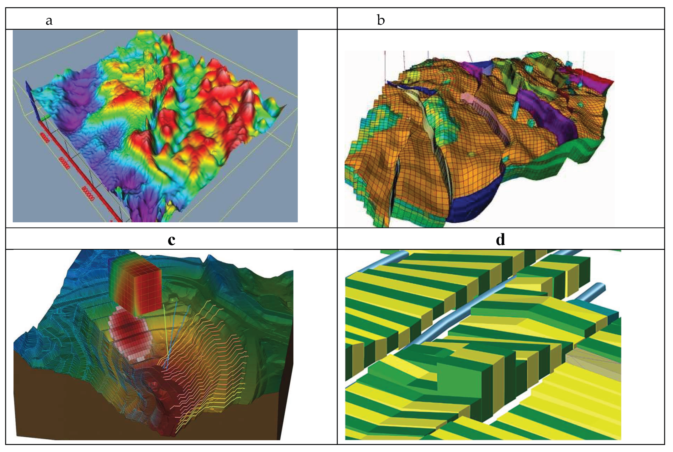
Figure 2.
Block diagram of the digital platform "Digital Caspian", which displays: Processes (stages of the technological process of preparing the Digital Caspian) - blue rectangles; Technical means used in the processes - software is listed in yellow diamonds; Intermediate results used to perform subsequent stages - pink multi-page documents. The results of each stage, which make up parts (blocks) of the Digital Caspian.
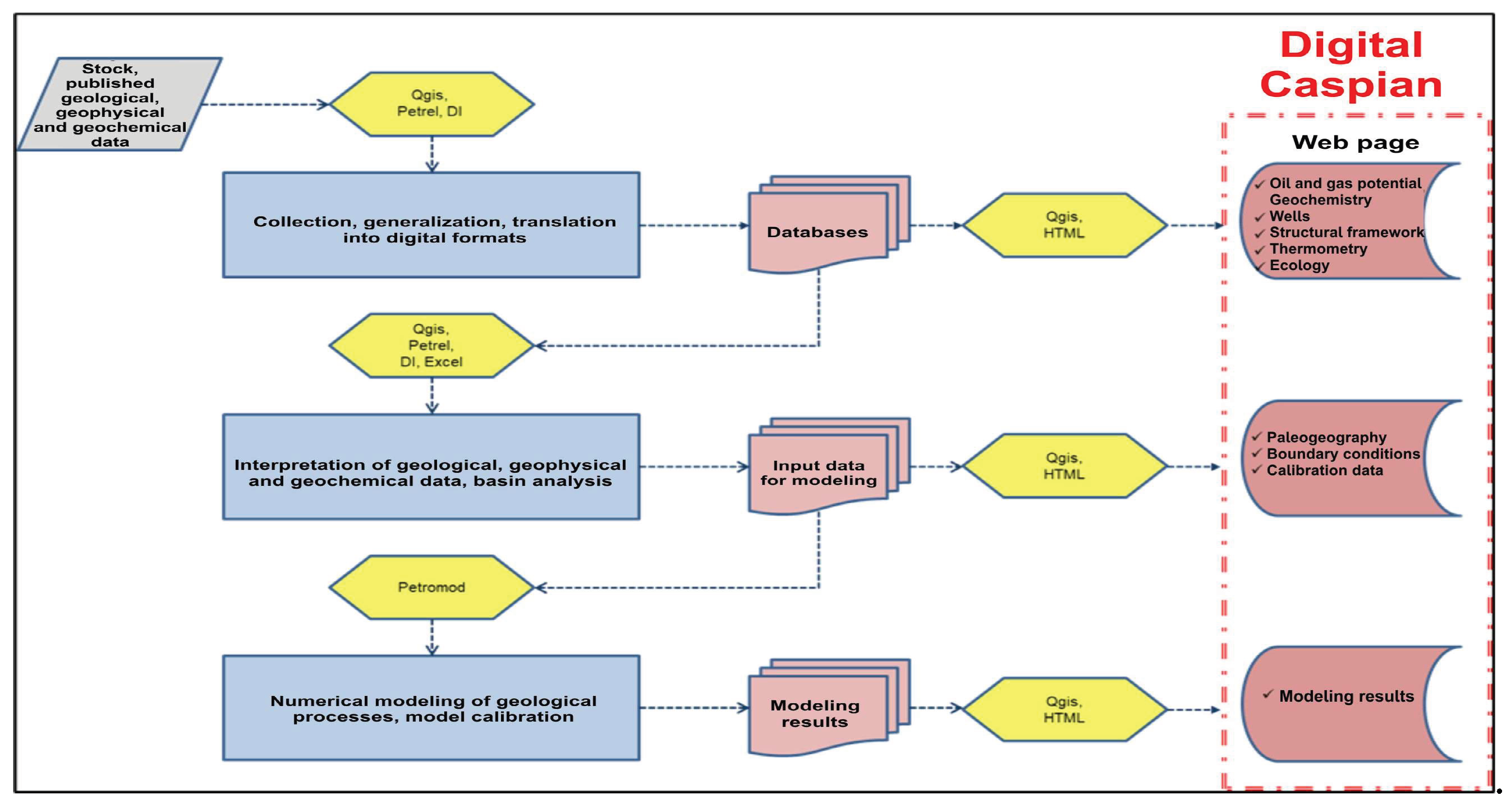
Figure 3.
The basic structure of the Digital Caspian IDB.
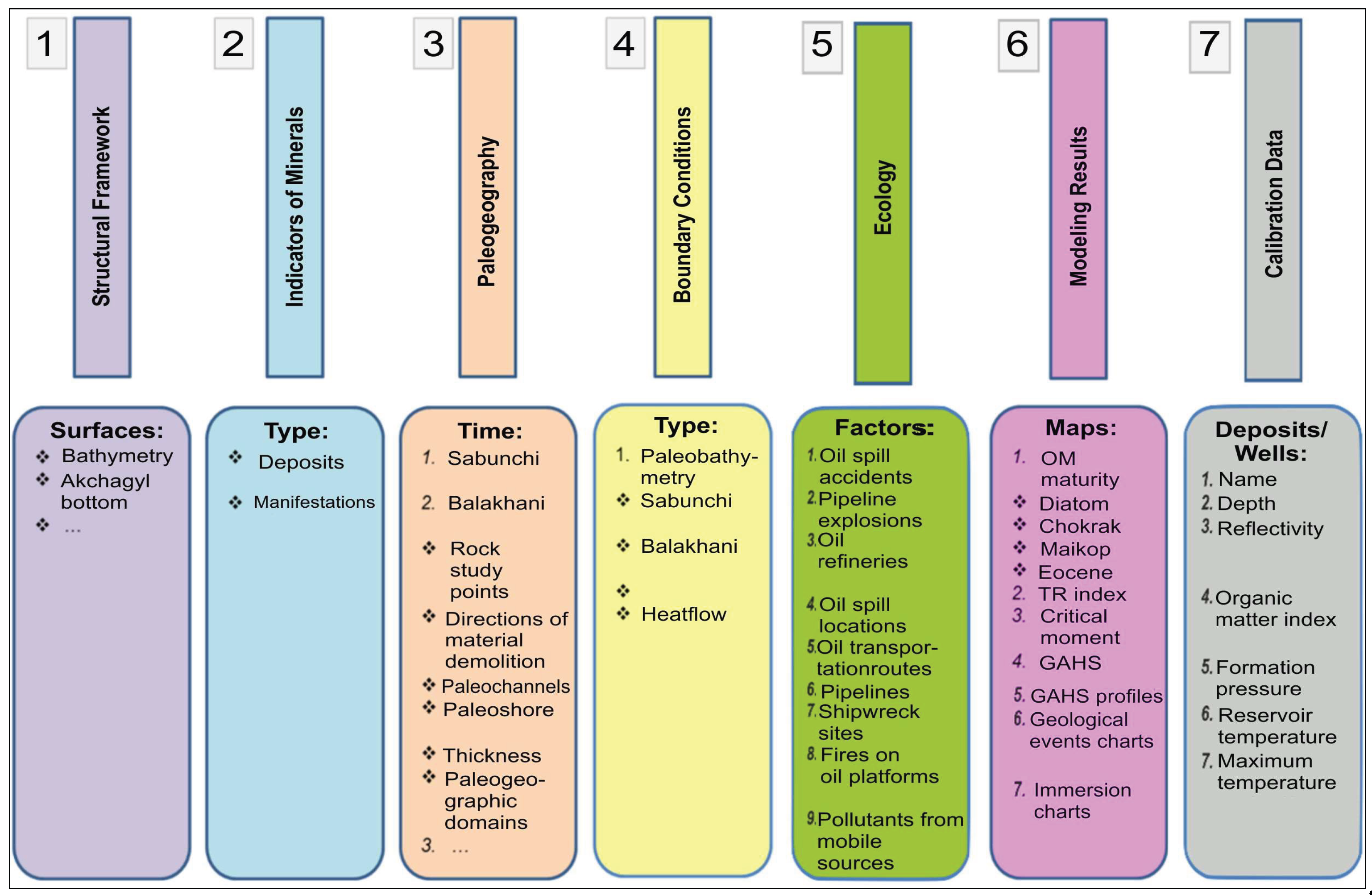
Figure 4.
Scheme of the life cycle of a solid mineral deposit.
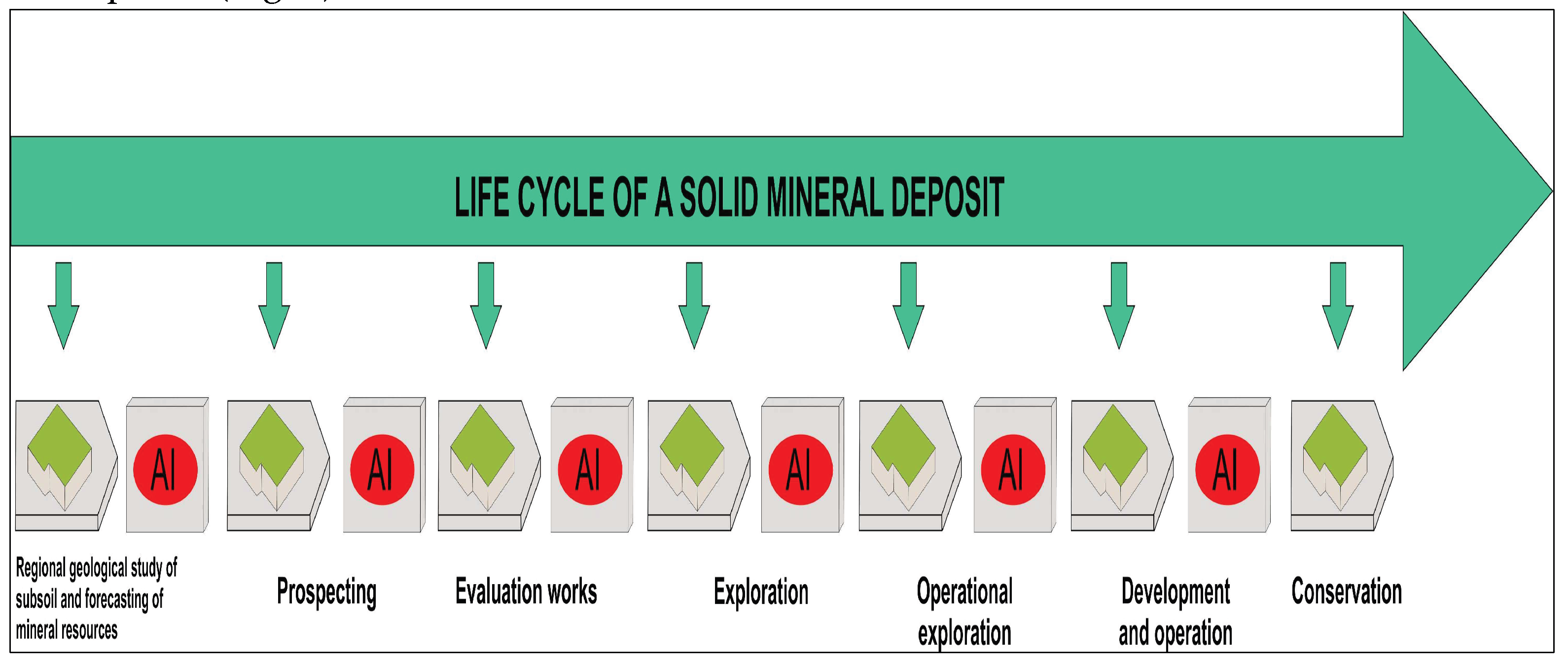
Figure 5.
Three-dimensional structural–spatial models of sedimentary basins: a – South Caspian Basin; b – Central Caspian Basin; c – North Caspian Basin.
Figure 5.
Three-dimensional structural–spatial models of sedimentary basins: a – South Caspian Basin; b – Central Caspian Basin; c – North Caspian Basin.
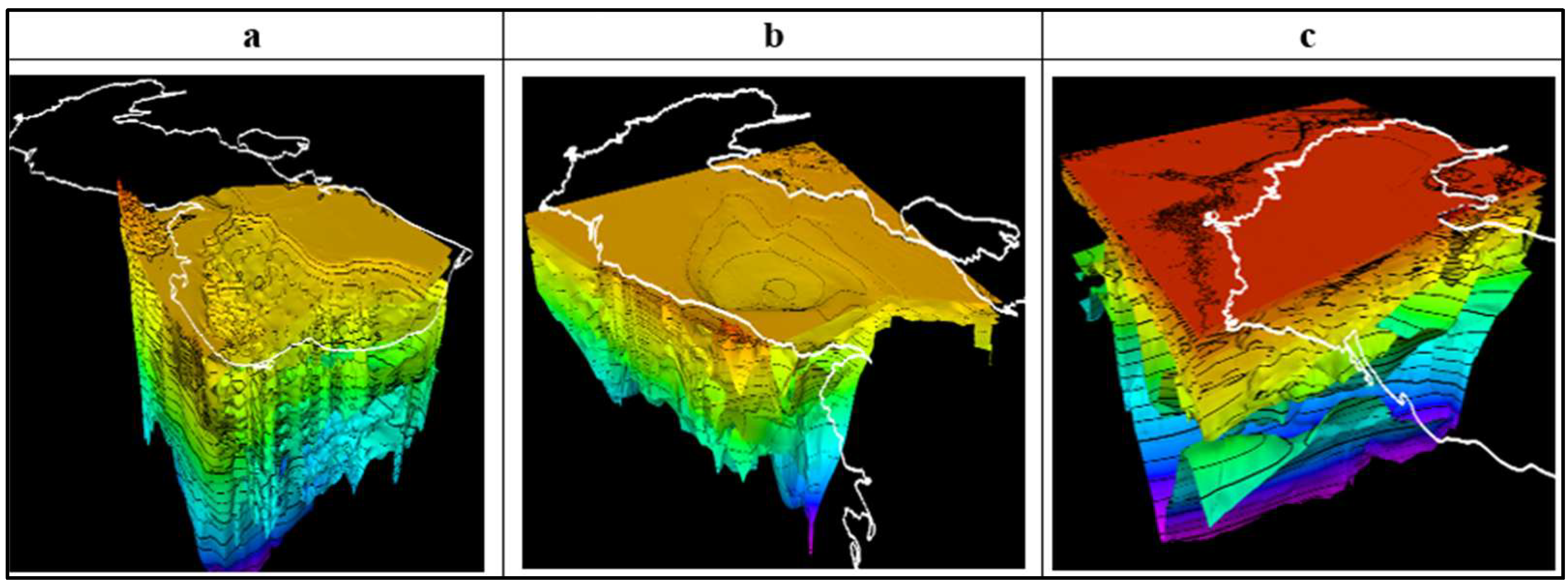
Figure 6.
Three-dimensional models of the surfaces of pre-Jurassic (a), Cretaceous (b), Eocene (c), Maikop (d), Pliocene (e) deposits of the Black Sea-Caspian region.
Figure 6.
Three-dimensional models of the surfaces of pre-Jurassic (a), Cretaceous (b), Eocene (c), Maikop (d), Pliocene (e) deposits of the Black Sea-Caspian region.
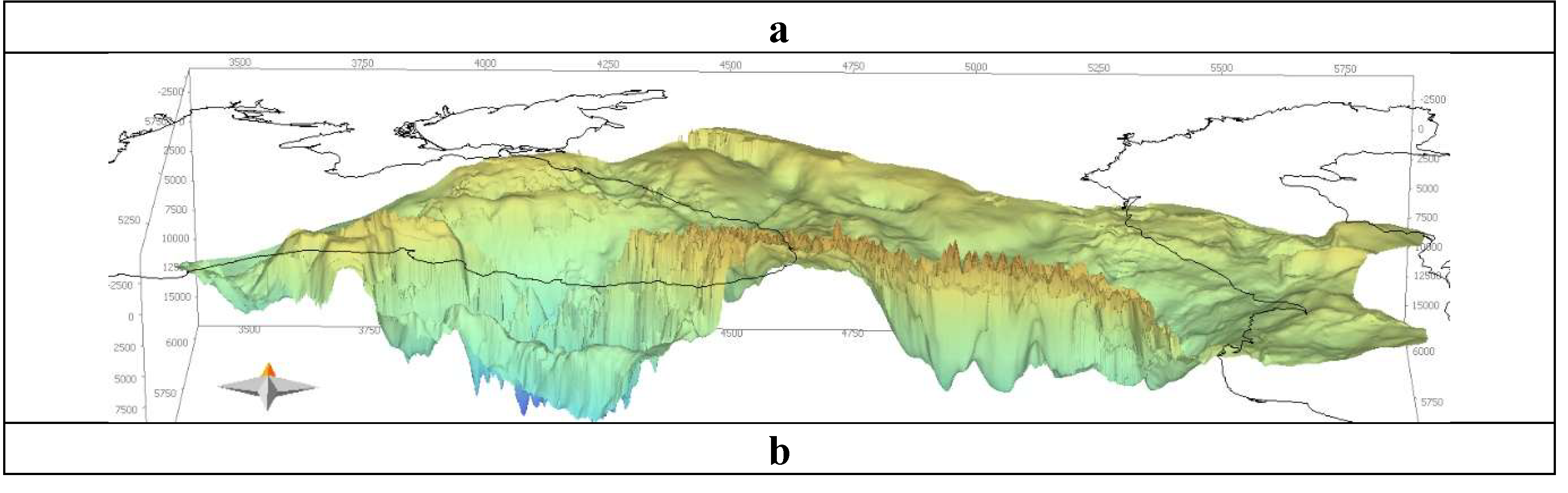
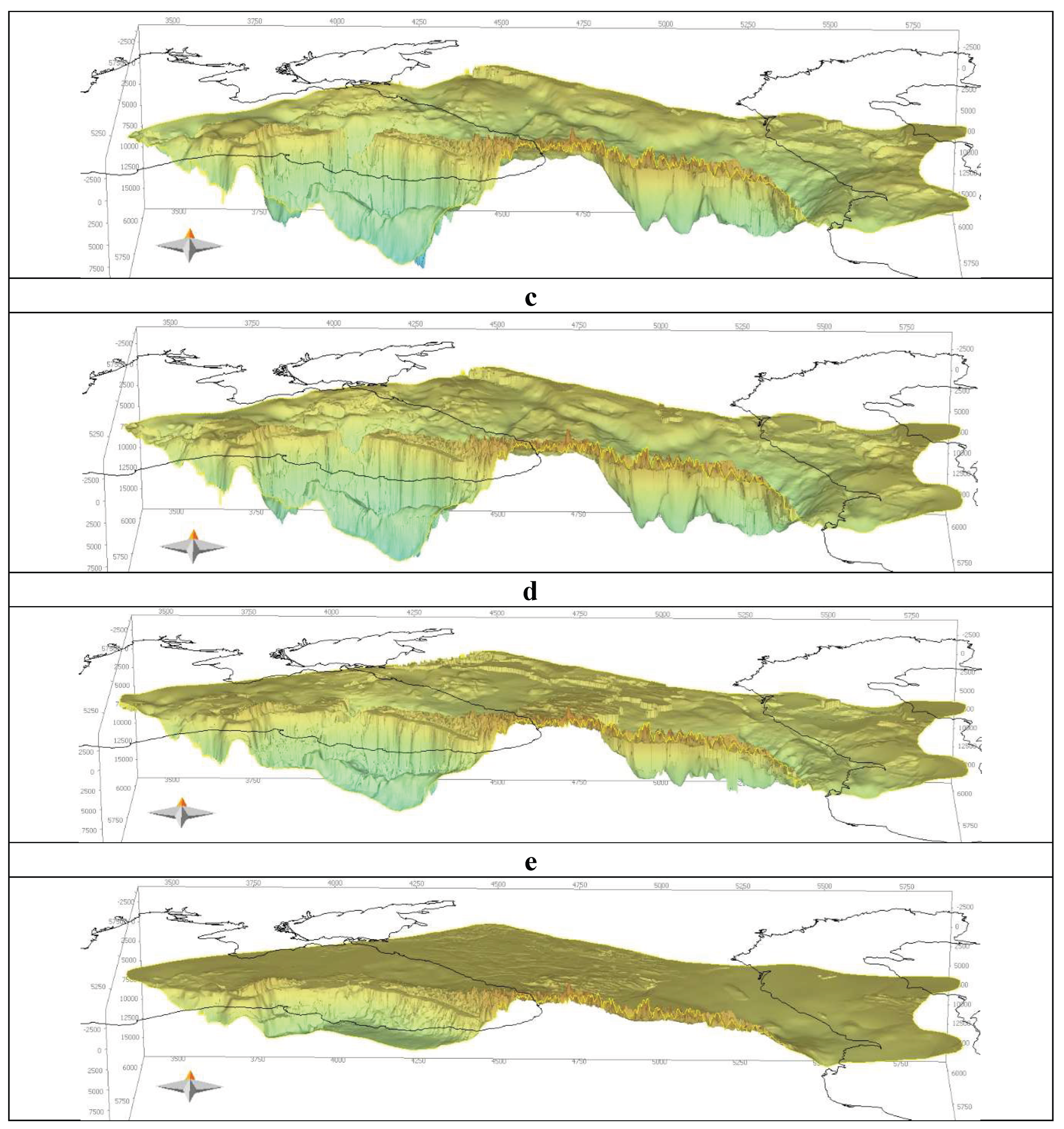
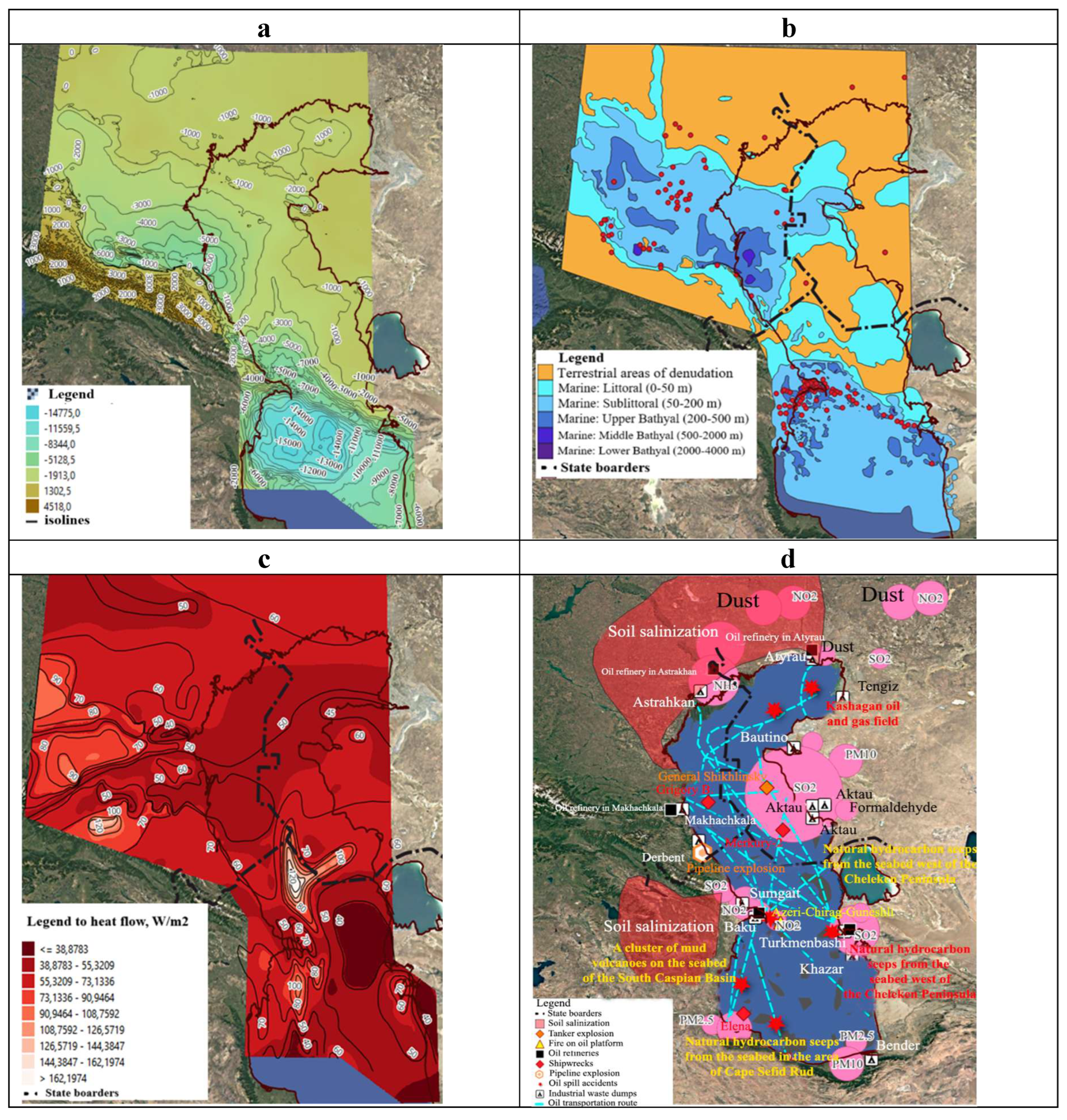
Figure 7.
Examples of digital maps derived from 3D models: a – structural–tectonic maps; b – paleogeographic maps; c – heat flow maps; d – environmental maps.
Figure 7.
Examples of digital maps derived from 3D models: a – structural–tectonic maps; b – paleogeographic maps; c – heat flow maps; d – environmental maps.
Disclaimer/Publisher’s Note: The statements, opinions and data contained in all publications are solely those of the individual author(s) and contributor(s) and not of MDPI and/or the editor(s). MDPI and/or the editor(s) disclaim responsibility for any injury to people or property resulting from any ideas, methods, instructions or products referred to in the content. |
© 2025 by the authors. Licensee MDPI, Basel, Switzerland. This article is an open access article distributed under the terms and conditions of the Creative Commons Attribution (CC BY) license (http://creativecommons.org/licenses/by/4.0/).
Copyright: This open access article is published under a Creative Commons CC BY 4.0 license, which permit the free download, distribution, and reuse, provided that the author and preprint are cited in any reuse.


