Submitted:
03 July 2025
Posted:
04 July 2025
Read the latest preprint version here
Abstract
Coastal urban areas play a strategic role in urban planning processes, as they are ideal contexts for implementing innovative transformative practices for communities. These areas are characterised by high population density and are subject to complex social, environmental and economic-productive dynamics that profoundly influence their evolution. Added to this is their significant landscape and functional value, which fuels expectations for development, making coastal areas the focus of growing interest from urban policies aimed at sustainability, resilience and integration between the anthropic dimension and natural systems. Waterfronts are configured as actual interfaces between the city and the sea, where fundamental assets for coastal community are juxtaposed, while needing appropriate planning to meet the complex needs of the users who enjoy them. The present contribution examines the approaches adopted by different cities in the Euro-Mediterranean basin in planning their city-sea interfaces in response to the socio-ecological challenges faced by urban coastal societies, particularly over the last five decades. Focusing on large coastal cities with more than half a million inhabitants, significant port infrastructure and rich cultural and historical attributes, the study aims to provide a comprehensive overview of coastal planning practices, examining whether they meet socio-environmental demands along the urban shore.
Keywords:
coastal public space
; urban regeneration
; coastal management
; city-sea interface
; urban amphibious
; Euro-Mediterranean basin
; urban coasts
; large coastal cities
1. Introduction. Regenerating Urban Waterfronts for Satisfying Socio-Environmental Demands
Coastal areas are undoubtedly a fundamental part of the urban system, as they are the point of contact between land and marine ecosystems, with significant theoretical and operational implications. Waterfronts represent a dynamic threshold between these two elements, within which the ecological and functional transition process develops in complex and heterogeneous ways, depending on the composition of the settlements and, by extension, of the coastlines themselves [1]. In some cases, there is no continuity between the coast and the water due to the presence of high cliffs or reefs; in other cases, the transition is more gradual and takes place through beaches, dune areas or low-lying stretches of shore.
These areas are home to extremely productive and diverse ecosystems, which have historically provided food resources, bases for trade and privileged places of settlement. The value of coastal areas has grown in proportion to economic development and demographic pressure, generating increasing competition between different uses and interests. Therefore, tensions related to integrated resource management emerge with greater intensity along urban coastlines, where often competing functions and environmental dynamics converge [2].
As a result, the management and development of waterfronts must take into account the specific characteristics of littoral areas, prompting reflection on planning and governance issues [3,4]. This complexity is further amplified by the fact that the processes that affect the quality of the shore often originate in places far from the coast itself: decision-making procedures that appear unrelated to the urban maritime context actually impact the way coastal spaces are used, as in the case of land uses that alter water regimes or cause erosion [5].
In this context, it makes sense to interpret urban coasts as a territorial interface, i.e. as a space of systemic interrelation between two ecological, physical and functional domains: specifically, the notion of city-sea interface identifies the contact area between the urban fringe and the coastal marine environment: this is an area of strong ecological and socio-functional interrelationship, where the two domains influence each other, generating complex co-evolutionary phenomena [6]. One of the criteria underlying this concept is the high population density, which acts as a catalyst for functions and intense relationships between the community and the water within heavily man-made areas, creating a continuum of community and spatial uses and dynamics. Due to the evolutionary complexity of contemporary waterfronts, the structure of the city-sea interface is characterised by a high degree of flexibility, influenced by significant socio-cultural, economic and productive flows, as well as ecological and environmental dynamics that define its conformation over time and determine its adaptive capacity [7,8].
On this basis, the concept of the city-sea interface can be viewed through the lens of the urban amphibious [9], which incorporates the ability of urban coasts and the communities that inhabit them to adapt dynamically to the conditions and pressures of the two contiguous environmental systems. The urban amphibious therefore represents a space of functional overlap between residential, productive, tourist, infrastructural and cultural uses, whose liminality constitutes a strategic resource for landscape enhancement and for the design implementation of waterfronts, while having to contend with the inevitable risk of exploitation by economic operators that can erode their value [10].Contemporary waterfronts also have significant social and cultural value: the areas of contact between cities and the sea host socio-recreational activities that make them highly attractive spaces and harbingers of identity values. These areas not only have important economic, productive and logistical implications within urban systems, but also reflect the community's demands for the enjoyment of places of great landscape value, especially in densely populated areas such as large settlements. As a result, anthropogenic and ecological pressures are gradually reaching peaks that must be taken into account in planning strategies and decisions. In the Euro-Mediterranean context, the dynamics described above are particularly acute. The Mediterranean is one of the areas with the highest settlement, tourism and infrastructure pressure. The environmental fragility of this region, exacerbated by extreme climate events that affect its coasts and combined with its economic and cultural importance, requires the adoption of advanced strategies for the sustainable management of coastal resources [11]. In this sense, the Mediterranean city-sea interface takes on a paradigmatic value in terms of coastal urban regeneration. In particular, public spaces facing the sea are acquiring a central role as mediators between defence infrastructure and environmental quality, between places of socialisation and equal access to the sea, making waterfronts true catalysts of urban resilience [12].
However, coastal urban regeneration involves balancing social, environmental and economic needs, which are often in tension with each other. In emerging economies, this conflict is intensified by the need to respond quickly to the essential needs of growing populations. The enhancement of the city-sea interface therefore requires an integrated assessment of ecosystem services, considering not only commercial aspects but also environmental, cultural and recreational ones, in order to promote the well-being derived from the social use of coastal urban space [13].
This contribution descended from studies developed within the international Galileo 2021 research project, entitled Re-SEA-ourcing CITY. City-sea interface as a resource for people: urban regeneration in the context of ecological transition, which aims to study the habitability of major Mediterranean coastal cities in relation to the liveability of their waterfronts, in the wake of growing social and environmental pressures on the coast that undermine the quality and accessibility of coastal spaces.
The research, developed by a multidisciplinary team from academic institutions in Italy and France, aimed to compare large coastal cities with a view to the significant number of users who visit them and suffer and exert strong multidimensional coastal pressures. Urban coasts bring numerous benefits to these cities in economic, environmental, energy and tourism-recreational terms, even though their significant heritage and landscape assets are exposed to human and ecological risks and challenges linked to coastal development itself [14]. Over time, this has led to the dynamic development of waterfronts, including the reclamation of useful space from the sea, in order to accommodate the multitude of old and new functions of the coastal public space and, at the same time, to defend against external risks, although these strategies have left their mark on the coastal-maritime ecosystem and have not always satisfied underlying social demands [15,16].
Within the framework of the Re-SEA-ourcing-CITY research project, therefore, the goal was to explore urban scenarios related to the evolution of coastal interfaces, investigating issues such as the adaptation to climate change, the equal accessibility to ecosystem services and littoral spaces, the sustainable port development and the ecological transition, through the lens of socio-recreational use of coastal space, which is the focus on which this paper will specifically delve.
2. Studying Large Coastal Cities to Analyse City-Sea Interface Planning and Design
Building on this, it is now analysed how different cities of the Euro-Mediterranean basin deal with the planning of their city-sea interfaces. These areas denote various types of vulnerabilities, as explained above: climate change, complex social demands of urban coastal society, fruition of the edges of the city-sea interface that is not always compatible with the geomorphological characteristics of the urban coasts. These factors have required specific management and planning approaches and methodologies over the last fifty years. Within the chosen spectrum of investigation, which is the European Mediterranean area, we will focus on large coastal cities, considering the urban agglomerations with a population of more than half a million inhabitants, usually linked to important port infrastructures but also endowed with relevant cultural and historical features.
The aim is trying to define a synthetic picture of the existing approaches to coastal planning within the context of the study, analysing whether these cities and their coastal interfaces actually respond in planning terms to the growing demand for proximity open spaces intended for social use, in relation to the main municipal websites and related documents (Figure 1).
Most of the French coastal surface is touched by the Atlantic Ocean to the west; however, an important Mediterranean littoral stretch connects the country to Spain and Italy. Although it is varied and multifaceted, its Mediterranean coastal strip has only one case of a large coastal city with a population of more than half a million of inhabitants: Marseille, with its 870,731 inhabitants [17], a thousand-year-old settlement that has undergone numerous transformations and expansions over the centuries. In relation with the investigation spectrum, the analysis of the French case is then reduced to the study of Marseille urban amphibious and its coastal projects. The strong link between the Marseille sea and urban socio-economic development has favoured a large number of functions within the coastal system over time. Historically, its coastal interface has hosted several points devoted to the fishing industry: in the past, this was a particularly flourishing sector, leading to the creation of various fishermen village (such as the area of L'Estaque, in the northern part of the city) and small harbours; today, although this activity is still present within the community, it is a secondary function of the urban coast. Another long-standing use along shore is port and logistics activity, in relation to the transport of goods but mainly of passengers: the leading commercial and productive port has in fact been relocated to Fos-sur-Mer, a small town approximately fifty kilometres away from Marseille, while the tourist function is still held along the littoral of the main urban core. This relocation has thus increased the possibilities for socio-recreational uses of the urban sea.
Similarly to France, also Spain presents a western oceanic side, but has a greater surface area of its coastal strip that is touched by the Mediterranean sea. It has also a denser coastal interface along which there are three urban polarities with more than half a million inhabitants [18]. For this reason, this paper will describe the actual city-sea interfaces of Barcelona, Valencia and Malaga, as port cities with important socio-recreational features. Barcelona represents the largest and most populated settlement (approximately a 1,700,000 inhabitants in 2018) among the Spanish cities: the development of its urban coast has been strongly influenced by some large-scale public events that have directed its transformation towards wide open spaces and places of representation; it is a complex case as the city combines planning approaches for the evolution of its waterfront with socio-cultural actions aimed at the well-being of the urban coastal society. The urban coast of Valencia, with its 791,413 inhabitants, follows a peculiar development, since it was founded away from the sea and it expanded towards the maritime zone only in more recent times: progressively, the urban development has saturated the available coastal areas, even if the integration with earlier littoral villages has not always been homogeneous, because of their a strong local identity; this characteristic clearly determines the direction in which the planning progress of public places along the coastal interface is directed. Malaga is one of the most important tourist destinations in Spain: the city has 571,026 inhabitants and is an appealing destination for a wide variety of users that compose its peculiar coastal community; its evident touristic inclination pushes the development of the coast from a recreational point of view, even if this implies a smaller quantity of proximity public spaces for the local society.
The Italian peninsula is completely immersed within the Mediterranean basin: its coastline presents a considerable extension, but even in this case, only three cities possess the necessary characteristics to be included within the analysis of city-sea interfaces with significant demographic size [19]. The main features of the urban coasts of Naples, Palermo and Genoa are therefore reported. The urban coast of Naples, inhabited by 921,142 citizens, has ancient origins and it is very rich in historical, cultural and identity values; anyway, it represents a special case because it has been absolutely static in its evolutionary process for several decades: despite the plans to design new waterfront areas and increase the available public spaces along the shore also for bathing uses, very few actions has actually been implemented along the complex Neapolitan coastal interface. The urban coast of Palermo (673,439 inhabitants) is configured as a gateway to the Mediterranean and its more exotic areas, considering its proximity to the African continent: this indicates that the urban-maritime interface of this city absorbs diversified influences, giving peculiar value to the cultural characteristics of urban coastal society. Finally, Genoa represents the coastal city with the lowest demographic density among the Italian cases, with 561,203 inhabitants: in spite of this, it is a place particularly tied to its urban coastline, especially in the port and logistic-productive context; however, there are some examples of transformation of the city-sea interface in social and environmental perspective.
As far as Slovenia, Croatia, Greece, Malta and Cyprus are concerned, the urban coasts of these states do not present cases of coastal cities whose size respects the minimum parameters defined for comparison with other Euro-Mediterranean settlements and their main existing coastal projects. In view of the subject of the study, it is therefore considered appropriate to examine the case of Marseille in France, the cases of Barcelona, Valencia and Malaga in Spain and the cases of Naples, Palermo and Genoa in Italy.
3. Real Estate and Social-Driven Planning for Coastal Open Spaces in France: The Case of Marseille
3.1. Large-Scale Interventions for Public Recreational Areas: The Parc du Prado and Pointe Rouge
The Marseille city-sea interface plays a fundamental recreational role for the users of urban coastal society: practices such as swimming, sport fishing, scuba diving, and boating take their place along the coast with events for sociality and maritime culture, both in the most densely populated areas and in the less frequented space of the shore. The urban shore of Marseille is thus configured as a relevant space for effective citizens but also for inland users [20]. The coastal area of the French metropolis has been subjected to different types of interventions aimed at increasing the functional permeability of the coast according to the socio-recreational uses of the littoral interface. These design and management actions have modified the conformation of the maritime public space, through wide-ranging interventions dating back to even decades ago, in the last century, as well as through more localised but equally valid operations to define the places of Marseille sociality.
The southern side of the city-sea interface is strongly characterised by the Parc Balnéaire du Prado, an important public space in contact with the sea, gradually realised since the mid-1970s (Figure 2).: it is a system of open areas serving the urban coastal society, with a surface of about 450,000 square metres and an extension of three kilometres along the coast. From the very beginning of the project, the area was studied because it was exposed to strong winds and wave motion, with the related environmental risks, but also to water pollution. For this reason, engineers and town planners have transformed the aspect of the Prado zone, expanding its surface area with land reclamation and beach nourishment in order to host community functions but also to resist the effects of climate change, such as coastal erosion [21]. The Prado Park consists of wide public beaches protected by artificial rocks, vast green spaces intended for sports and recreation, and limited areas in which larger commercial facilities are concentrated, with a few service spots distributed over the total area. This intervention therefore proposes a highly artificialized landscape area, whose originality lies in functionally reorganising the different areas of the urban amphibious, creating a place along the shore that is very appreciated and frequented by the citizens of Marseille from a recreational point of view. The urban beaches are completely integrated into the city's territory, connecting important fragments of the urban-maritime system through good accessibility conditions: the park is located close to the important Marseille promenade, the Corniche, linking the Prado Park to the city centre. For the purposes of this contribution, it is therefore interesting as the available land resource appears to be significantly low today, especially for such a large-scale transformation intended to create open areas for the coastal community [22].
In continuity with the Prado beach park is located the Pointe Rouge area, in the 8th Arrondissement (Figure 3 and Figure 4). This is a public space that present a tourist harbour, from which ferryboats depart, and another urban beach, one of the largest in the city, where various recreational activities take place and where numerous users are welcomed in the summer season, especially families, due to its shallow sandy seabed. The beach area, with its characteristic half-moon shape, occupies about 7,000 square metres and is the result of a coastal land reclamation dating back to the last two decades of the last century. Between 2016 and 2020, the area underwent an intervention for the redevelopment of the bathing space, enhancing the public space surface and demolishing the various illegal constructions from the coastal public domain: Pointe Rouge was in fact characterised by many accommodation buildings and restaurants that crowded the sandy portion of the shoreline without permissions; the project aimed to regularise the land use and concessions, thus designing easiest accesses to the sea and guaranteeing pedestrian continuity within the bathing system. Moreover, the intervention sought to realise light buildings intended for refreshment activities with walkways and paths in order to clearly define the public nature of the space facing the sea and allow a broader enjoyment of the coastal landscape, while endowing the area with adequate services and equipment [23]. In this case too, it is thus configured a proximity public space in which citizens can equally benefit from the sea resource.
3.2. Missed Coastal Permeability in the Euroméditerranée Real Estate Operation
In the central sector of the Marseille coastal interface, it is located another type of transformation of the coastal and nearby port neighbourhood, with different outcomes in terms of social functionality, namely the Euroméditerranée 1 and Euroméditerranée 2 projects. The aim of this major urban intervention in two parts is to revitalise the city centre of Marseille, although the operation has not always achieved its objectives.
At the beginning of the 1990s, the national authorities agreed on the creation of an actual driver for territorial and economic development through a multifunctional operational programme, focusing mainly on the tertiary sector and on the culture, tourism and leisure fields, in order to create lively and attractive spaces for both citizens and potential investors. The economic nature of this project is therefore immediately evident. In 1995, the planning procedure started, under the guidance of a special public body called Établissement Public d'Aménagement Euroméditerranée (EPAEM), composed by almost sixty experts and a board of directors with national and local representatives. Cooperation with socio-economic facilitators has also been established to negotiate spatial and community strategies in order to involve different stakeholders: urban marketing has great value to channel investments along the city-sea interface [24]. The project involves the realisation of an urban area of approximately 168,000 square metres: approximately a quarter of the total surface is intended for public use facilities and open spaces (Figure 5).
In particular, some recreational and cultural areas in contact with the urban sea have been implemented, exploiting the southern portion of the city port that has been granted to social uses: the result of the transformation of the former J4 - La Joliette pier is a water square that acts as a hinge between the port infrastructure and the urban centre, connecting to the pedestrian path that runs along the Vieux Port. This space, freely usable by citizens, hosts some relevant cultural buildings, such as the MuCEM (Musée des civilisations de l'Europe et de la Méditerranée), a national museum created from the former Museum of Popular Arts and Traditions, now dedicated to Mediterranean cultures and connected to the close Fort Saint-Jean (Figure 6), and the multifunctional shopping centre Les Terrasses du Port, a significant point of visual contact with the city water, through its large terrace, from which it takes its name and which allows users to experience the aquatic space dedicated to cruise ships, almost as if the building itself were a ship docked on the coast of Marseille (Figure 7). Interestingly, the urban coastal society exploits this public space to enjoy contact with the sea, even in a spontaneous way, for example through the unplanned bathing activity nearby the MuCEM buildings: the Marseille municipality plans in fact to legally regulate this activity. The Euroméditerranée plans also include the development of an urban park close to the Grand Port Maritime de Marseille (GPMM), transforming the disused railway line into a green lung that could, among other things, reduce the problems related to the hydraulic risk in the area. In spite of these important planning premises, it is necessary to note that the transformation of this piece of the city so close to the sea does not necessarily mean that the users of its coastal society can actually benefit from the effects of the urban regeneration: in fact, the area appears to be a relevant real estate operation that has led to the construction of large buildings similar to urban containers, with a related strong gentrification that undermines the usability of the Marseille urban coastline [25,26,27]. Furthermore, although the intention of the plan is to reconnect the city to the sea, the presence of strong constraints creates a fracture in the city-sea interface that has not been healed yet: in this sense, it is possible to refer to the port itself, mostly inaccessible and gated, and the motorway overpass that emerges in this area, severely limiting the visual perception of the maritime resource and lowering the general urban quality (Figure 8).
3.3. Plage des Catalans and Parc de Corbière: Localised Interventions for Social Contact with the Sea
The Marseille coastal interface is also characterised by more localised actions on coastal public spaces. Nearby the Vieux Port the Plage des Catalans is located: it is one of the city's oldest urban beaches, with an area of approximately 2,000 square metres that has hosted users of Marseille community for more than two centuries for socio-recreational practices such as bathing and outdoor sports. The ongoing project for this relevant area aims to extend the beach space as much as possible, offering varied and equally usable services while enhancing the cultural heritage of the site. In fact, the area is defined by ancient porticoes signalling the boundary between the beach and the road outside, but also a 16th century tower with high architectural value, now abandoned but originally used as a lazaret, from whose function it borrows its name (Figure 9).
The transformation of the Plage des Catalans therefore aims at rehabilitating the abovementioned historical porticoes, so that they can host bathing support services with special attention to users with reduced mobility, and the Tour Lazaret, which will host cultural functions. The functional redistribution of spaces includes the relocation of the existing beach volleyball courts from a central position to a more detached one, allowing for a spatial increase of about 1,300 square metres for bathing and sunbathing uses; the project defines also two new coastal public squares on either side of the beach, in favour of urban sociality: moreover, the planning interventions followed a participatory process, with the dissemination of questionnaires among the users of the Marseille society, in order to gather their needs and desires about the transformation of this coastal public space [28].
Besides, the sea facing the Plage des Catalans hosts an innovative underwater museum space, free of charge and accessible to all. In 2021, the Musee subacquatic de Marseille was inaugurated: it represents a peculiar and innovative experiment in Europe, allowing social and sustainable fruition of the urban sea, stimulating cultural activities and monitoring the marine biosphere through special sensors integrated in the artworks exhibited below the water level. Ten sculptures are currently submerged at a depth of only five metres and are located one hundred metres away from the shore: they therefore fit perfectly within the parameters of safety and easy recreational water enjoyment for ordinary users [29].
The Corbière Park in the northern part of the city, near the municipal border, in the 16th Arrondissement, is also part of this social reclamation of the city-sea interface. Centuries ago, the area was urbanised as a fishermen village: its iconographic fortune is related to artists such as Cézanne who highlighted its landscape value.
The large public space covers an area of about 20,000 square metres and is strongly characterised by the presence of an impressive arch viaduct supporting a railway track, at the basis of which the bathing site is located (Figure 10). It was realised at the end of the Seventies, with the aim of granting accessibility to the sea for the local community, since this feature was limited by the presence of L'Estaque harbour in the most central area of the district: the park is composed by two sandy beaches, surrounded by a terraced garden with a particularly favourable microclimate condition, thanks to the surrounding rocky cliff. The site is intended to be a gateway to the city-sea interface mainly for the local community; it presents a prevalent natural character, which the municipality tries to preserve, and notable architectural and landscape elements; added to this is the presence of a nautical club aimed at promoting maritime sport and culture, especially for sensitive segments of the society, like users with disabilities and children.
However, despite its extension, the beach site is still limited because of the human flows it has to deal with: a large part of the shore of the 16th Arrondissement is in fact occupied by port infrastructures and private nautical clubs, limiting the equal usability of the sea; furthermore, the site shows evident infrastructural issues that prevent users to easily reach it.
4. Major Events and Local Projects for the Development of Coastal Public Space and Urban Beaches in Spain: Barcelona, Valencia, Malaga
4.1. The Effect of Large Events on the Open Spaces of Barcelona's Coastal In-Terface
The Barcelona coast has undergone urban transformations over the last half-century, becoming an important example for other social and culture-led planning approaches, integrating community activities and inclusive processes with the environmental and economic fields. The urban coastline is strongly influenced by the beach element and its use along the city-sea interface has progressively increased since the 1960s, leading to growing pressures between social expectations and public and private interests for economic and productive development. For this reason, until the 1980s, most of the local beaches underwent a rapid process of ecological and environmental degradation that strongly conditioned their usability; in addition to this, there were large stretches of coast that were privatised for different reasons, subtracting useful land for the sociality of citizens. The socialist political transition of 1979 led the planning of the coastal interface towards greater protection of community needs and spatial justice: this is a crucial node in the creation of the future Barcelona model. The creation of new public spaces and the qualitative transformation of the existing ones can be considered as tools for the promotion of social cohesion, reflecting the intention to include coastal society within governance processes [30].
Linked to this is the 1986 nomination to host the 1992 Olympics: this public great event will shape the development of community areas in Barcelona. In fact, although the city had already taken a virtuous path of urban and coastal transformation, the application provided considerable national and regional economic resources to catalyse public ambitions for city growth. The interventions included a general infrastructural improvement of the city, enhancing accessibility to the coastal interface areas, and the creation of areas for sports and leisure: indeed, one of the objectives is opening of the city to the sea, distributing public facilities and services along the urban shore, according to a holistic approach [31]. The transformation of Port Vell has thus generated a multifaceted coastal recreational area. In particular, the Passeig Maritim is configured as one of the first interventions, in the Barcelona recent redevelopment, to give aesthetic but also social consistency to the urban littoral, which was a degraded space in the city, mainly used for productive purposes. The planned pedestrian area thus allows a greater usability of the city-sea interface, also from a landscape point of view: the area is defined by the visual and physical permeability towards the sea, while the presence of open spaces between the buildings favours sociality and functional flexibility in favour of coastal recreation, allowing different forms of relationships among the users of the urban coastal society in heterogeneous spatial contexts [32]. Moreover, the Passeig Maritim promenade constitutes a link between the Olympic Village and the popular Barceloneta area (Figure 11). In this area, the homonymous beach is located: it is one of the oldest beaches in the city and measures just over four hundred metres in length; the beach limit is characterised by elements to facilitate accessibility to the sea for users, with an inclusive view to users with reduced mobility, while the bathing space is also equipped for sport activities. However, it must be considered that the planning of this area of the city-sea interface is influenced by private investment that directs its development towards a more entrepreneurial component (especially for the tourism industry) rather than towards purely social purposes: for a long time, this area of the city waterfront, together with the nearby Somorrostro beach, has hosted extremely poor urban settlements with around 15.000 inhabitants; the urban quality of the site certainly needed to be restored in favour of greater liveability, but the coastal transformation has evidently altered the community composition of the place [33,34].
It should be noted that, at the end of the century, the transition to a more conservative management of the city and the coast led to a progressive opening towards coastal transformations guided by private investors: in this light, the intervention on the Diagonal-Mar area and on the related coastal area of Poblenou can be read (Figure 12) [35]. Once an urban area dedicated to industrial production, it was thus reconverted into a high-level accommodation and recreational area, hosting different uses especially in favour of the richest groups of coastal society. Simultaneously, the town planners started to work on the Universal Forum of Cultures, a 2004 four-monthly event of international relevance: the location for this project was a working-class neighbourhood, in order to revalue it [36]. The urban project led to the realisation of a large coastal public space of approximately 200,000 square metres, with related public facilities and buildings.
The cultural root of the event was channelled into an economical perspective and once again focused on the economic development of the waterfront, catalysing the growth of the reference neighbourhood [37]. If the intervention on the Diagonal-Mar area is linked to a private initiative mainly related to urban marketing that produced exclusive urban models for users of higher classes, the operations related to the Forum of Cultures have a public-led nature: however, the resulting large empty spaces and generally unused buildings symbolise an unsuccessful strategy [38]. However, through this urban coastal project, Barcelona's city-sea interface still benefits from an artificial access to the sea within the Forum area. The homonymous bathing establishment is equipped to carry out the same activities as on the beach, but on a paved surface in continuity with the sea water. Its size is about 11,000 square metres and it is characterised by its great environmental value, considering the presence of a relevant marine biodiversity: in this bathing area, researchers have identified more than five hundred marine species, including exotic fish, shellfish and seaweed [39].
4.2. Reconnections Between City and Sea and Community Expectations for the Valencia Urban Shore
Regarding the evolution of the Valencian city-sea interface, it is interesting to note that the city's original location was far away from the sea. For this reason, during the industrial age, the urban evolution of the city led to the gradual dissolution of the urban boundaries dating back to the medieval period and started a process of reunification of the settlement fabric with the maritime-coastal space, gradually defining the contemporary littoral interface of Valencia. From the second half of the last century, new neighbourhoods saturated the area between the old medieval city and the sea: the original settlements of the local coast, namely the villages of El Cabanyal-El Canyamelar and Natzaret, were absorbed by the larger urban core, together with their need for facilities and services; on the other hand, the progressive development of the port led to the deterioration of the living conditions of the inhabitants of the back-port areas, locked in a pincer between the incipient urban advance towards the sea and the growth of the logistical infrastructure, with consequent phenomena of urban segregation, exacerbating social differences [40].
In any case, in 1988, the approval of the Plan General de Ordenación Urbana (PGOU) led to new strategies for the qualitative implementation of the city's coastal context: even then, the idea of urban regeneration of the maritime city, including the urban waterfront, came to the fore through the concept of a Balcón al Mar, a multi-scalar planning initiative involving various aspects of coastal transformation that took shape in 2004 [41]. The project involves the northern area of the port and reaches the area of the Malavarrosa beach: the intervention aims to rebuild the contact between different urban areas marked by the presence of a massive infrastructure such as the harbour, creating a zone dedicated to pedestrians and sociality; in fact, the plan proposes the realisation of services to satisfy cultural and recreational needs, connecting the coastal and back-port districts with a soft mobility system and creating open spaces and green areas for social functions along the coast, as well as reconverting degraded buildings and sites [42]. Specifically, the project involves a large urban park of approximately ten hectares, with recreational facilities and leisure areas: the function of the green area, in addition to increasing the social value of the coastal interface, is to compensate for the anthropic impacts of the port intervention, following the path of a new access channel to the wharf, thus playing an important ecological role in Valencian planning. This intervention has originated in 2003 from the designation of the city to host the 32nd edition of the America's Cup, an important sailing event whose management led to the creation of the Consorcio Marina de Valencia [43]: since 2007, its role is to coordinate urban planning projects for the urban coastal interface, together with representatives of the central government, the Valencian regional authority and the Council of the City of Valencia. In the same vein it is possible to consider the subsequent works for the transformation of Valencia seafront, namely the Juan Carlos I Marina, dating back to the first decade of the 2000s: in this case, the impact on real estate costs in the involved coastal neighbourhoods was inevitable, as a consequence of urban development (Figure 13 and Figure 14) [44]. The Consorcio considered the growth model adopted to be sustainable, as it privileged spaces intended for the community and the free social enjoyment of the coast, eluding as far as possible commercial uses along the city-sea interface, such as hotels and shopping centres; in any case, the development of the Marina has had a negative impact on the social structure of the coastal districts, as it has strongly modified the existing urban fabric and community composition, provoking the discontent of the original coastal society and damaging its strong identity value [45,46].
From this point of view, the case of the coastal district of El Cabanayal is interesting. As previously mentioned, this settlement corresponds to an ancient fishermen village that, since the 13th century, had colonised the stretch of coastline currently adjacent to the Valencian port. At the beginning of the 20th century, the district became more and more dependent on Valencia, although it maintained its own distinct spatial and social characteristics. However, with the modern urban development towards the sea, it was incorporated by the larger municipality, through the construction of the Blasco Ibáñez Avenue that connected the city with El Cabanyal. Despite the fact that the entire district had been preserved since 1993 due to its historical and cultural value, a plan for the development of the area was launched in 1998, with the extension of Avenida Blasco Ibáñez and the consequent demolition of a large number of buildings [47]: on the one hand, the intention was the qualitative improvement of this important coastal area, enhancing its aesthetic value; on the other hand, this would have caused a strong economic pressure on the neighbourhood, compromising its socio-identity aspects so intimately connected to the city-sea interface. The result was a strong community contestation that obstructed the planning course, through a wide range of community-based activities to raise awareness of the traditional, cultural, architectural, heritage and social value of the maritime district [48,49]. In 2015, the public authorities decided to uphold the social complaint, drafting the Integrated Sustainable Urban Development Strategy (ISUDS) for the coastal interface within El Cabanyal area: the strategy involved an interdisciplinary team and a highly participatory process, in order to incorporate the demands of the coastal community as much as possible [50,51]. From the recreational point of view, the area is characterised by the presence of the homonymous beach: its length is approximately two hundred linear metres and, although it is a place intended mainly for neighbourhood sociality, there is no lack of tourist services, such as hotels, restaurants and commercial activities. Bathing is facilitated by the installation of specific facilities and the nearby promenade becomes a meeting and social point for local users.
4.3. Tourist Influence on Recreational Activities Along the Malaga City-Sea Interface
Malaga is a city located along the Costa del Sol, on the southern side of Mediterranean Spain, and represents one of the main tourist destinations related to bathing in the entire state. It is the second largest Spanish coastal city in terms of number of foreign tourists, hosting an average of 1.3 million visitors annually: around 60% of them come from other countries. Moreover, it is considered the urban destination with the highest tourist growth in Spain [52]. For these reasons, its tourist industry is very dynamic today. From a morphological point of view, the urban coastline is profoundly characterised by sandy beaches, consequently this element of the city-sea interface represents one of the main social, functional and landscape cornerstones of Malaga [53].
According to these features, bathing areas have been developed over time in order to respond to the needs of users. In this sense, the case of the area of Pedregalejo could be interesting: it is an old fishermen village located in the eastern part of Malaga, a few kilometres from the main urban centre. Since the Eighties of the last century, the settlement (now an effective urban district) has been progressively transformed, partially losing its traditional character in favour of a more tourist-recreational implementation. The coastline was thus modified with the construction of a complex system of inlets ending in breakwaters in order to protect the narrow coastal strip and at the same time recover land necessary for creating a system of pocket-beaches. Although relatively decentralised, this public space of the city-sea interface is now a destination for citizens and tourists, in relation to access to the sea and the presence of accommodation functions [54].
Westwards from Pedregalejo beach, there is a further element of coastal sociality, namely the Baños del Carmen. This is a fairly small green area equipped for bathing, with an extension of approximately 550 metres and an average depth of 5 metres, whose name recalls the old thermal baths built in 1918 as a leisure area for the high society of the time. Since 2010, a process of extension of the current beach area of the Baños del Carmen has been officially approved, with the installation of breakwater elements and the coastal connection with the nearby beach of Pedregalejo, as well as the implementation of the vegetated spaces of the site, in order to improve its usability with new facilities for cultural and sports functions and internal pedestrian paths: however, the project is still in progress (Figure 15) [55].
Malaga's relevance within the Mediterranean basin is also linked to its port and its role as a hub for important goods and passenger traffic. The city has studied a number of solutions to encourage porosity between the port infrastructure and the urban core, where these entities overlap, seeking to balance their values in favour of the community.
From these reasonings, the recreational area of Palmeral de las Sorpresas was developed, a space of about 20,000 square metres located within the harbour area, as a hinge with the city system. Inaugurated in 2011, the site is characterised by a long sun-shading structure designed by Santiago Calatrava and is characterised by the presence of green areas and spaces for recreation in contact with the sea: the boundary with the areas destined for logistical activities is clearly marked by glass barriers that do not, however, interrupt the visual enjoyment of the water resource; on the other hand, mobility by bicycle is limited to certain specific areas, due to the port regulations in force.
The Palmeral de las Sorpresas is connected to another green space within the local city-sea interface: the Parque de Malaga is a 30,000 square metres vegetated area, composed by bicycle and pedestrian paths and public gardens available for the local population. The area also serves as a green filter between the heart of the city and the port area, acting as an important element within the littoral green-blue infrastructure. In both cases, however, the use of green areas near the coast suffers from strong tourism pressure due to their central location, even though they constitute an interesting example of planning integration between urban greenery, the city and the sea (Figure 16) [56].
5. Waterfront Transformations and Static Urban Shores in Italy: Naples, Palermo and Genoa
5.1. Large-Scale Vision for Urban Coastal Redesign: The Immobility of the Naples Shore
The city-sea interface of Naples is characterised by an incredible richness of historical, cultural and social values, not inferior to the other Euro-Mediterranean case studies analysed in this contribution, but it also denotes a peculiar character of planning and design stagnation, since most of the interventions planned over the last decades have not yet seen the light, remaining essentially on paper. In fact, the Neapolitan metropolis suffers from a slow process of urban evolution, still dealing with issues already faced in European and non-European cities with a similar size [57]. Added to this is the particular criticalities of the overlapping competences between the municipal authority and the port authority, which holds the management of coastal areas located even outside the harbour perimeter.
In its central area, dominated by the tourist ferry terminal, namely the Molo Beverello, the transformative intentions of the Neapolitan coastal interface still focus on the waterfront project: attention is paid to repair the fracture between sea, port and city, taking into account the functional but also landscape values of the zone. Specifically, the project, recently inaugurated, proposed to preserve the port's autonomy while establishing a visual and functional continuity between the two areas of the urban amphibious: to do this, a linear infrastructure, defined as a filtering line, has been designed along the urban-port boundary perimeter in order to host, on several levels, green areas, tourist, commercial and service buildings, car parks, and spaces for sociality [58]. The road section has been modified, creating a pedestrian route that acts as a visually permeable limit between the uses of the city and the activities of the port, connecting the main points of the central portion of the urban shore, with the aim of creating a linear public space (Figure 17) [59]. However, it should be emphasised that the intervention area mainly concerns the most representative and tourist part of the Naples city-sea interface: the connection with Piazza Municipio unifies the sea and the urban centre, although the eastern periphery of the port infrastructure basically remains linked to its shipyard and logistical function, without a real urban reconnection [60,61].
Regarding San Giovanni a Teduccio, a neighbourhood close to the eastern end of the port of Naples, the area falls within the perimeter of the Site of National Interest (SIN) Napoli Orientale, with an extension of approximately 830 hectares, including the maritime area in front of the industrial site located there. The SIN (that is an area within the Italian territory with environmental and socio-cultural values threatened by ecological risks, identified by law for recovery measures [62]) was established through Law 426/98 and can be divided into four main areas, namely the Oil Pole, where petrochemical, mechanical and logistics companies operate, the Gianturco area with mainly manufacturing and commercial companies, the Pazzigno area where various small companies are located, and finally the coastal strip. The latter extends from the port to the municipal boundary with Portici: it is a complex area as it includes elements related to the abandoned industrial heritage, such as the thermoelectric power plant and the purifier, but also areas used by the local community for bathing purposes (even if this activity forbidden due to the severe water pollution) and zones dedicated to cultural activities, like the Pietrarsa Museum, as well as coastal heritage elements to be regenerated, such as the fort of Vigliena [63,64]. Although operational plans have been promoted for the positive transformation of this coastal urban area, there is a general planning immobility that clashes with the social demand for public space for recreation and contact with the sea resource [65].
On the opposite side of the Neapolitan shore, another SIN zone has been identified, namely the Bagnoli-Coroglio area: dating back to the mid-19th century, this area was a productive site, although the first significant factory was built at the beginning of the last century, with the construction of the Ilva steel factory (Figure 18). This infrastructure was definitively decommissioned in 1991, but the prolonged productive use of the area has severely damaged the surrounding coastal-maritime ecosystem. For this reason, the SIN extends for about 250 hectares on the mainland and 1,450 hectares in the adjacent sea, according to its new surface drafted on 8 August 2014. In 2020, an international ideas competition was launched for the functional transformation of this stretch of coastline once used for industrial activities [66]. The urban project selected proposes the creation of a large natural park that includes elements of industrial archaeology: the designed functions involve large, vegetated areas, a productive woodland that recalls the original rural use of the area and an urban park that acts as a link between the more naturalistic zone and the existing urban fabric with a mainly residential function. In a similar way to the existing pedestrian pier, additional floating walkways are proposed, together with an implementation of urban beaches, trying to recover the existing coastal area, in front of the dismissed productive plant, that is mainly composed by debris from steel production8 (Figure 18) [67]. The planning action therefore envisages a large area for recreation and leisure, although it is awaiting actual realisation.
5.2. Port-City Relations and Social Reclamation of Degraded Coastal Spaces in Palermo
The Sicilian capital has a complex coastal landscape: its general status is in a negative condition from an ecological and planning point of view, due to various cases of illegal constructions, the presence of illegitimate discharges into the sea and the failed implementation of adequate socio-environmental recovery projects. From the point of view of bathing, there are no actual points within the city that are used for this function, which is often banned or in any case limited: Palermo's urban beaches are located outside the proper city centre and tend to become critically crowded during the summer due to the flows of both citizens and tourists. Nevertheless, the coast is quite prone to welcome future recreational and sport developments related to the sea, in the presence of appropriate planning processes [68].
The transformation of the city-sea interface is characterised by the port waterfront evolution project, approved in 2018. The wide-ranging intervention is characterised by the intention to green up a large part of the urban coastline linked to the transport infrastructure, reconnecting it with the innermost urban fabric and creating penetration axes that favour the visual quality of the maritime landscape. It is proposed to realise a space for cultural, tourist and socio-economic activities in the city, creating urban hinges between the tourist harbour and the urban centre, through the redevelopment of areas of historical value such as the Molo Trapezoidale, in functional continuity with the Castello a Mare (in whose area an urban lake is defined) and the twentieth-century buildings. In this area, there is the objective to enhance the public enjoyment of the archaeological elements through the creation of a public park, equipped with cultural and refreshment services to support the definition of a new littoral pole. Attention is therefore paid to the general urban quality, with a view mainly to tourist fruition and architectural enhancement of the existing buildings, in a large-scale vision, although the contact with the sea is mainly visual, for obvious functional reasons related to the logistic use of the area [69] (Figure 19 and Figure 20).
The Port Authority of Palermo thus plays a major role in local governance: its involvement in urban decision-making processes is linked is crucial in the case of the Foro Italico, a green space in the urban heart in close contact with the sea. The area, owned by the port authority, serves as an urban connection between the city and the sea, yet for decades it has been in a state of environmental and functional degradation. Towards the end of the old millennium and the beginning of the 2000s, the local society managed to persuade the port authority and the municipality to deal with the presence of illegal activities, in favour of renewed urban safety, limiting the sources of ecological issues. The site was thus transformed into a vegetated esplanade, an urban garden that is now very popular. Its 90,000 square metres host spaces for outdoor recreational and sport activities, creating an important filter between the chaotic city and the urban sea, whose landscape can be fully enjoyed [70]. Although there has been a lack of further real interventions to transform and fully equip this public space, it remains an emblematic case of community reclamation of an important fragment of city-sea interface, close to particularly urbanised areas (the city port and the historic centre), activated by social listening of users’ demands and needs (Figure 20).
5.3. Genoa Littoral Between the Renewal of the Port Area and Socio-Economic Transformations
The city of Genoa occupies a prominent place in the North Mediterranean context thanks to its urban coastline shaped by intense logistical activity and cultural and social impulses. In particular, for almost a century its production processes and economic dynamics have generated substantial demographic growth: however, the industrial crisis that began in the post-war period marked a turning point in the decline of Genoa’s coastal development. Between the 1970s and the 1990s, the population dropped from around 800,000 to almost 600,000; the low amount of available land, combined with the strong functional competition of the various productive activities along the coast, deeply undermined the accessibility of the city-sea interface, also in relation to the inevitable high costs for the different littoral uses [71].
In this context, the intervention in the Porto Antico area fits in as an element of renewal of the urban image and a potential spur for the economic recovery of the city. The functional motivation of this project was the realisation of exhibition spaces and public places in contact with the sea, in coincidence with the 1992 International Colombo Exhibition: this area is in fact the ideal place for representations and events; furthermore, following the Exposition, the city would have gained equipment and spaces for its citizens, creating a new pole of attraction for urban development (Figure 21). The project is also linked to the growing awareness that the urban coastline could be a neuralgic element within the urban system even beyond its productive relevance, representing a real opportunity for socioeconomic redemption through the promotion of leisure areas and activities related to tourism: the need for the organisation of spaces in favour of the evolution of the city-sea interface thus becomes essential [72].
In the same vein is the project of the so-called Levante Waterfront, one of the main contemporary operations for the city of Genoa, as it is focused on attracting funding through spatial transformation: the design action is in fact linked to the intention of revitalise the Genoa urban shore in an economic way, exploiting the various advantages of the area, such as its easily reachable position, its proximity to various urban services and obviously its contact with the maritime system. The planning process seeks to meet the desire to restore the seafront along the urban littoral interface. The area is occupied by varied uses, both public and productive: the overall design tries to give them coherence and balance. The final aim is the valorisation of a potential coastal pole in order to guarantee urban development and economic profit [73].
On the other hand, a different approach is taken for the realisation of the Parco Urbano delle Dune di Genova-Prà, a green hinge between the port infrastructure and the city behind it. The project of this public space has implied the participation of several actors operating within the coastal interface, including the Port Authority, the Region and the Municipality. From the design point of view, the intervention proposes a linear park, equipped for recreation and leisure, running along the urban coastal strip and creating a system of dunes from which the operation takes its name [74]: this intervention also acts as an environmental buffer, absorbing the impacts and noise emissions of the machinery in the area and screening the rear urban settlement. The urban project is in fact part of the European RUMBLE programme, aimed at reducing the noise impacts of port infrastructures [75]. The action includes the continuation of the existing promenade and the realisation of four public squares, functionally integrated with each other: attention is paid to the theme of pedestrian accessibility, enhancing the connection between city and water. From an environmental perspective, the park also benefits from interventions of ecological engineering, including grassing and tree planting, over a total area of approximately 30,000 square metres. It is also worth emphasising that, unlike other projects implemented in the city of Genoa, this initiative goes beyond the mere incorporation of an ecological component aimed at improving urban quality. Instead, it constitutes a true central element of the city, positioned within the city–sea interface, and conceived as a space offered to the urban coastal society, responding to its needs (Figure 22).
6. Different Project Approaches and Outputs to Implement Coastal Socio-Recreational Values
This review of projects and interventions implemented or being implemented for the city-sea interfaces of the large cities in the Euro-Mediterranean basin aimed to study the relationship that urban coastal institutions and societies have with the theme of sociality, recreation and ecological benefit along their seashores. It emerged that there are in fact very few examples of proximity public spaces explicitly designed for local enjoyment, to ensure constant contact with the urban aquatic resource as a function of psycho-physical well-being and environmental implementation. In the context of the ecological transition of the contemporary urban amphibious, this issue has particular relevance because spatial proximity to community places reduces anthropogenic pressures related to transports and allows for a better social distribution of coastal services along urban littoral.
The French case proves to be one of the most emblematic. In fact, even if it is the only large city analysed, according to the parameters set out above, Marseille offers its citizens several areas destined to the free enjoyment of the sea and the coast, although the central area of the urban coast is occupied by the GPMM, which drastically reduces littoral accessibility: in this respect, except for the J4 – La Joliette zone, the public spaces offered by the Euroméditerranée programme guarantee little results in function of the promised permeability, at least visual, towards the sea. It has to be said that majority of these spaces are strongly influenced by tourism (an element, in any case, very relevant for the economic sustainability of such places): yet some elements of the Marseille city-sea interface really indicate the importance of the community in the definition of recreational places. It is possible to think about the case of the Plage des Catalans, which proposes a valid example of urban beach, nestled between sport facilities and cultural and museum elements within the urban core: it is not a coincidence that it is one of the most popular beaches among Marseille users, a community particularly active in claiming its rights in terms of accessibility to the sea. At the same time, the municipal authorities have shown a certain inclination for social listening over the years.
Spain offers three case studies of large coastal settlements, within which notable differences in the design of the coastal interface can be observed. Broadly speaking, the country's coastal development appears to be strongly influenced by great events and the large influx of tourists who visit the Spanish coasts annually, primarily for short- to medium-term stays linked to seaside activities. The city of Barcelona is very much influenced by the international fair events that have taken place there: in fact, they have been a driving force for the qualitative improvement of the coastal areas, although some of the facilities built to date still do not have a real use, just as the creation of large zones for citizens and tourists has undoubtedly undermined the original identity value. For Valencia, the situation differs considerably, as here too the great events linked to sailing competitions have had a relevant impact on coastal planning: however, in relation to the identity value of the local communities, atypical situations can be examined, for example in the El Cabanyal area, where the urban coastal society has expressed strong disagreement towards an excessively touristic transformation of the old maritime neighbourhood. Finally, Malaga is characterised by the presence of several urban beaches, albeit slightly detached from the city centre: actually, this could reduce tourist pressure, although these places are still very popular. In any case, the intention to mend the complex relationship between the port infrastructure and the city, through elements of green-blue infrastructure, is also relevant.
The Italian urban coasts are characterised by a different approach to the urban amphibian project as they are still linked to more traditional waterfront regeneration interventions, mainly in ports. Naples and Genoa are strongly influenced by this infrastructure and its implementation, attempting to mediate on an urban level the connection between harbour and urban fabric. If, however, Genoa has really moved on to the implementation level of some of the operations conceived for its waterfront, the Neapolitan case is characterised by a certain degree of immobility in urban planning, since many projects have been realised on paper but to date very few stretches of the city-sea interface have actually been transformed: moreover, serious socio-environmental problems persist in the most peripheral areas of the Naples urban coast. Similarly, the study of Palermo's coastal interface highlights a similar design effort to connect the city and the sea functionally and visually through the filter of the port; however, there is also a strong social component that has achieved lesser but nonetheless important results in the social reclamation of some open spaces intended for public use of the urban water resource.
To conclude, it is emphasised that in fact the urban design of proximity spaces with high socio-environmental value has different results in the various countries examined within this research, usually going towards large interventions with a tourist-cultural root that cannot always meet the real needs of the urban coastal community. In most cases, functional permeability characters are pursued, in order to allow the distribution of public functions that can somehow relieve the pressure on the dense city, despite the planning complexity to achieve integration between the urban fabric and the maritime sphere.
7. Conclusions
The contribution sought to express the complexity of contemporary waterfront management and design in the light of evolving community needs. Social and environmental issues are becoming increasingly essential for understanding these places, whose evolution requires careful theoretical, design and social analysis in order to move towards responsible and efficient strategic and operational decisions.
At the end of the last century, coastal development was strongly influenced by the incipient tourist industry and the transformation of coastal areas into spaces linked to leisure, commercial uses and, in essence, a more aesthetic approach to urban design, born out of the industrial decommissioning season; however, with the advent of the new millennium, communities have become increasingly attentive to other, more inclusive parameters and dedicated to ecological quality. The use of coastal public space has in fact become a proxy for needs related to the enjoyment of environmental and landscape values that are often difficult to find in other areas within dense cities. This could probably be one of the reasons that have prompted communities to demand more and more interventions at the local level, far from the logic of consumption and exponential economic growth: in fact, waterfronts are the image with which citizens identify themselves in relation to the sea that bathes urban coasts, placing increasing emphasis on concepts such as place attachment, spatial justice and equitable access to maritime resources [76,77].
Communities and their evolution are in fact intrinsically linked to the development of the city-sea interface and the spaces that allow it to be enjoyed. This clearly emphasises the need to include actions aimed at consolidating the ecological structure within coastal planning, regardless of the scale of reference: the benefits are undoubtedly social and functional, considering the undeniable value that green-blue infrastructure elements have for the liveability of places, as well as for the defence of the urban amphibious environment against climate dynamics, whose impacts tend to be increasingly frequent and require adaptive and flexible approaches.
A further point that emerged is that the cities analysed have very different ways of designing and managing coastal space, as a function of specific demands of the different urban coasts, but also of variously oriented management models. This clearly opens up the scenario for detailed comparisons: this contribution should be intended as a way to benchmark coastal strategies and projects with a marked socio-recreational nature. In this way, the paper's goal was to create a dialogue basis between interventions that are geographically and methodologically distant yet linked by the common thread of research into community use of waterfronts.
Author Contributions
Pistone has written paragraphs 1, 3 and 4, while A. Acierno has drafted paragraphs 2, 5 and 6. The conclusions are joint work by both authors.
Conflicts of Interest
The authors declare no conflicts of interest.
References
- Song, K.; Choi, Y.; Hyo-Joo, H.; Chon, J. Adaptation and transformation planning for resilient social-ecological system in coastal wetland using spatial-temporal simulation. Science of The Total Environment 2011, 789. [Google Scholar] [CrossRef] [PubMed]
- Smith, H.D.; Maes, F.; Stojanovic, T.A.; Ballinger, R.C. The integration of land and marine spatial planning. Journal of Coastal Conservation 2011, 15(2), 291–303. [Google Scholar] [CrossRef]
- Carter, C.; Drouaud, F. Territory, ecological transition and the changing governance of ports. Territory, Politics, Governance 2022, 12(3), 374–394. [CrossRef]
- Kay, R.; Alder, J. Coastal Planning and Management, 2nd ed.; CRC Press: London, United Kingdom, 2005. [Google Scholar] [CrossRef]
- Cetin, M. Sustainability of urban coastal area management: A case study on Cide. Journal of Sustainable Forestry 2016, 35(7), 527–541. [Google Scholar] [CrossRef]
- Robert, S. L’urbanisation du littoral: espaces, paysages et représentations. Des territoires à l’interface ville-mer; Université de Bretagne Occidentale (UBO): Brest, France, 2019. [Google Scholar]
- Üzümcüoğlu, D.; Polay, M. Urban Waterfront Development, through the Lens of the Kyrenia Waterfront Case Study, Sustainability 2022, 14(15). [CrossRef]
- Ollivro, J. De la mer au meritoire. Faut-il aménager les océans? Editions Apogée: Rennes, France, 2016. [Google Scholar]
- Worthington, D. (Ed.) The New Coastal History. Cultural and Environmental Perspectives from Scotland and Beyond; Palgrave Macmillan: London, United Kingdom, 2017. [Google Scholar] [CrossRef]
- Pistone, I. Urban Coasts in Socio-ecological Transition. A Methodological Framework to Support Planning and Management of the City-Sea Interface, 1st ed.; Springer: Cham, Switzerland, 2025. [Google Scholar] [CrossRef]
- Clemente, M.F.; Perney, M.; Pistone, I. Climate Change and Coastal Tourism: Vulnerabilities, Impacts and Policies in the Euro-Mediterranean Context. Sustainable Planning Perspectives in Italy and France. In Networks, Markets & People. NMP 2024. Lecture Notes in Networks and Systems; Calabrò, F., Madureira, L., Morabito, F.C., Piñeira Mantiñán, M.J., Eds.; Springer: Cham, Switzerland, 2024; pp. 83–92. [Google Scholar] [CrossRef]
- Hoskyns, T. Waterfront Public Spaces and Collective Assemblages. In Rethinking Stormwater Management through Sustainable Urban Design; Cheshmehzangi, A., Sedrez, M., Flynn, A., Eds. Springer: Singapore, 2024; pp. 117–131. [Google Scholar] [CrossRef]
- Vollmer, Urban waterfront rehabilitation: can it contribute to environmental improvements in the developing world? Environ. Res. Lett. 2009, 4, 1–7. [CrossRef]
- Vale de Paula, P.; Gonçalves, J.M. Urban Regeneration of Waterfronts: Literature Review. In XV Seminario Internacional de Investigación en Urbanismo, Lisboa-Recife 2023, Universitat Politècnica de Catalunya, Universidade de Lisboa Universidade Católica de Pernambuco; pp. 1-14. [CrossRef]
- Tommarchi, E. Waterfront Redevelopment Five Decades Later: An Updated Typology and Research Agenda. Ocean and Society 2025, 2. [Google Scholar] [CrossRef]
- Hudson, B.J. Cities on the shore. The urban littoral frontier; Pinter: New York, New York, 1996. [Google Scholar]
- Insee - Institut national de la statistique et des études économiques. Dossier complet, Commune de Marseille (13055). Available online: https://www.insee.fr/fr/statistiques/2011101?geo=COM-13055 (accessed on 15 June 2025).
- INE - Instituto Nacional de Estadística. Available online: https://www.ine.es/en/index.htm (accessed on 15 June 2025).
- ISTAT - Istituto nazionale di statistica. Available online: https://demo.istat.it/?l=it (accessed on 15 June 2025).
- Robert, S.; Laffont-Schwob, I. Le littoral marseillais. In Marseille et l’environnement. Bilan, qualité et enjeux. Le développement durable d’une grande ville littorale face au changement climatique; Guiot, J., Mazurek, H., Curt, T., Raimbault, P., Eds.; Presses universitaires de Provence: Marseille, France, 2021; pp. 147–170. [Google Scholar] [CrossRef]
- Cabioch, B.; Robert, S. Les enjeux de la gestion des plages à Marseille. Une mise en perspective avec Barcelone et Valence (Espagne). In Maritimité(s) en région Provence-Alpes-Côte d'Azur; Bouffier, S., Robert, S., Eds.; L'Atelier méditerranéen: Presses Universitaires de Provence, Marseille, France, 2024; pp. 113–127. [Google Scholar] [CrossRef]
- Hérat, A. L’aménagement des plages du Prado à Marseille: la construction d’un bien commun. In Inégalités écologiques, territoires littoraux & développement durable; Deboudt, P., Ed.; Presses universitaires du Septentrion: Lille, France, 2019; pp. 223–235. [Google Scholar] [CrossRef]
- MIRA – Architecture; Paysage. Plage de Pointe Rouge, Marseille. Available online: https://ateliermira.fr/index.php/portfolio-item/pointe-rouge/ (accessed on 12 June 2025).
- Grondeau, A. Durabilité, urbanité et mixité dans les opérations d’intérêt national (OIN): les exemples d’Euroméditerranée (Marseille) et de l’Écovallée Plaine du Var (Nice). Bulletin de l’association de géographes français. [CrossRef]
- Malterre-Barthes, C. Euroméditerranée: The Mute Streets of Marseille. Built Environment 2025, 2, 234–254. [Google Scholar] [CrossRef]
- Aroua, N. Design for Climate Adaptation. From Theory to Practice. Euromed II-Marseille Case Study (France). In Design for Climate Adaptation. UIA 2023. Sustainable Development Goals Series; Faircloth, B., Pedersen Zari, M., Thomsen, M.R., Tamke, M., Eds.; Springer: Cham, Switzerland, pp. 209-222. [CrossRef]
- Bergsli, H. Envisioned landscapes on Marseille’s waterfront. In Changing Places: Urbanity, Citizenship & Ideology in New European Neighbourhoods; Cremaschi, M., Eckardt, F., Eds.; Techne Press: Amsterdam, Netherlands, 2011; pp. 34–63. [Google Scholar]
- La Ville de Marseille - Plage des Catalans. Available online: https://www.marseille.fr/mer/plages-et-baignade/plage-des-catalans (accessed on 12 June 2025).
- Musée Subaquatique de Marseille. Available online: https://www.musee-subaquatique.com/fr/ (accessed on 12 June 2025).
- Blakeley, G. Local governance and local democracy: the Barcelona model. Local Government Studies 2005, 31(2), 149–65. [Google Scholar] [CrossRef]
- Baroghi, F.; Ribeiro, P.J.G. Olympics-related urban interventions in Barcelona and in Rio de Janeiro: A look at territorial equality legacies. Cities 2024, 155. [Google Scholar] [CrossRef]
- Degen, M. Modelar una «nueva Barcelona»: el diseño de la vida pública. In La metaciudad: Barcelona transformación de una metrópolis; Degen, M., García, M, Eds.; Anthropos Editorial: Barcelona, Spain, 2008; pp. 83–96. [Google Scholar]
- Nofre, J.; Giordano, E.; Eldridge, A.; Martins, J. C.; Sequera, J. Tourism, nightlife and planning: challenges and opportunities for community liveability in La Barceloneta’. Tourism Geographies 2018, 20(3), 377–396. [Google Scholar] [CrossRef]
- Crespi-Vallbona, M.; Mask-Miró, O. La transformación y gentrificación turística del espacio urbano. El caso de la Barceloneta (Barcelona). EURE, 2018; 44, 51–70. [Google Scholar] [CrossRef]
- Camerin, F. From “Ribera Plan” to “Diagonal Mar”, passing through 1992 “Vila Olímpica”. How urban renewal took place as urban regeneration in Poblenou district (Barcelona). Land Use Policy, 2019; 89. [Google Scholar] [CrossRef]
- Camerin, F.; Córdoba Hernández, R. Interrogating event-induced but underused infrastructures. The white elephants of Spanish mega-events linked to the neoliberal urbanism of the recent decades. In Events and Infrastructures. Critical Interrogations; Grabher, B., Lamond, I.R., Eds.; Routledge: London, United Kingdom, 2024; pp. 22–40. [Google Scholar] [CrossRef]
- Casellas, A.; Pallares-Barbera, M. Public-sector intervention in embodying the new economy in inner urban areas: the Barcelona experience. Urban Studies 2009, 46(5), 1137–1155. [Google Scholar] [CrossRef]
- Degen, M.; Garcìa, M. The Transformation of the ‘Barcelona Model’: An Analysis of Culture, Urban Regeneration and Governance. International Journal of Urban and Regional Research 2012, 36(5), 1022–1038. [Google Scholar] [CrossRef]
- Pontes, M.; Salvador, X.; Parera, À.; Álvarez, G.; Ballesteros, M. Biodiversity in anthropized marinas The case of the Barcelona Forum bathing area (Spain); Institució Catalana d’Història Natural: Barcelona, Spain, 2021. [Google Scholar] [CrossRef]
- Salom, J.; Fajardo, F. Cambios recientes en la estructura territorial sociodemográfica del área metropolitana de Valencia (2001-2011). Boletín de la Asociación de Geógrafos Españoles 2017, 73, 123–147. [Google Scholar] [CrossRef]
- Llavador, J.M.T. Plan de reordonacíon de la ciudad de Valencia. Proyecto Balcón al Mar – Reorganisation Plan of the City of Valencia. Balcón al Mar Project. PORTUS 2004, 8, 52–61. [Google Scholar]
- Caparrós i Gironés, P. Urban transformation on the waterfronts of Valencia and Bilbao. PEOPLE: International Journal of Social Sciences, 2009; 4, 1011–1025. [Google Scholar] [CrossRef]
- Lecardane, R. Le front de mer de Valencia et l’héritage de l’America’s Cup 2007. Méditerranée. Revue géographique des pays méditerranéens 2008, 111, 109–114. [Google Scholar] [CrossRef]
- Martí, P.; Garcìa Mayor, C.; Melgarejo, A. Waterfront landscapes in Spanish cities: regeneration and urban transformations. In Urban Growth and the Circular Economy; Syngellakis, S., Ed.; WIT Press: Southampton, United Kingdom, 2018; pp. 45–56. [Google Scholar] [CrossRef]
- Clemente, M.; Giovene di Girasole, E.; Oppido, S. Grandi e piccoli eventi nelle città di mare per mutamenti urbani sostenibili: i casi studio di Lorient e Valencia. TRIA 2012, 5(9), 73–90. [Google Scholar] [CrossRef]
- del Romero Renau, L.; Trudelle, C. Mega Events and Urban Conflicts in Valencia, Spain: Contesting the New Urban Modernity. Urban Studies Research, 2011. [CrossRef]
- Hervás Más, J. El barrio del Cabanyal-Canyameral de Valencia: historia y futuro. Ciudad Y Territorio Estudios Territoriales ( 2017, 49, 81–97. [Google Scholar]
- Santamarina Campos, B. ; Mompo, Eva. Tácticas de resistencia en la ciudad alternativas desde los movimientos urbanos en El Cabanyal (Valencia, España). AIBR: Revista de Antropología Iberoamericana. [CrossRef]
- Cuesta Ávila, R. Procesos de asimilación y resistencia urbanas en el marco de la globalización. Aproximaciones al Barrio Chino de Barcelona y al barrio del Cabanyal de Valencia. Revista Nuevas Tendencias en Antropología 2011, 2, 104–146. [Google Scholar]
- Peris, J.; Bosch, M. The paradox of planning for transformation: the case of the integrated sustainable urban development strategy in València (Spain). Urban Transform. 2020. [Google Scholar] [CrossRef]
- Ilisei, R.D.; Salom-Carrasco, J. Urban Projects and Residential Segregation: A Case Study of the Cabanyal Neighborhood in Valencia (Spain). Urban Sci. 2018, 2(4), 1–19. [Google Scholar] [CrossRef]
- Chica-Olmo, J.; González-Morales, J.G.; Zafra-Gómez, J.L. Effects of location on Airbnb apartment pricing in Málaga. Tourism Management 2020, 77. [Google Scholar] [CrossRef]
- Molina, R.; Manno, G.; Villar, A.C.D.; Jigena-Antelo, B.; Muñoz-Pérez, J.J.; Cooper, J. A. G.; Pranzini, E.; Anfuso, G. The Effects of Anthropic Structures on Coastline Morphology: A Case Study from the Málaga Coast (Spain). Journal of Marine Science and Engineering, 2025; 13. [Google Scholar] [CrossRef]
- Hsu, J.R.C.; Yu, M.J.; Lee, F.C.; Benedet, L. Static bay beach concept for scientists and engineers: A review. Coastal Engineering 2010, 57, 76–91. [Google Scholar] [CrossRef]
- Royo Naranjo, M.L. Proyecto cultural Baños del Carmen: Una mirada por encima del agua. eDap : documentos de arquitectura y patrimonio 2013, 5, 20–29. [Google Scholar]
- Andrade, M.J.; Costa, J.P.; Jiménez-Morales, E.; Ruiz-Jaramillo, J. A City Profile of Malaga: The Role of the Port-City Border throughout Historical Transformations. Urban Planning 2021, 6(3), 105–118. [Google Scholar] [CrossRef]
- De Martino, P. Naples: a city away from water: The role of path dependence in the history of Naples. Planning Perspectives 2023, 39(1), 179–194. [Google Scholar] [CrossRef]
- Salimei, G.; Pavia, R.; Di Venosa, M. ; Nava, Consuelo; E. B. S., G. Progetto di Riqualificazione urbanistica, architettonica e funzionale dell’area monumentale del porto di Napoli. Molo Beverello 2024.
- Carta, M.; Ronsivalle, D. (Eds.) The Fluid City Paradigm. Waterfront regeneration as an Urban Renewal Strategy; Springer: Cham, Switzerland, 2016. [Google Scholar] [CrossRef]
- Gargiulo, C.; Cerrone, D. Il mare non bagna Napoli: il lento processo di riqualificazione del waterfront. PORTUS plus 2011, 1. [Google Scholar]
- Rubino, G. Napoli città-futura. Rives méditerranéennes 2011, 39, 45–63. [Google Scholar] [CrossRef]
- Ministero dell'Ambiente e della Sicurezza Energetica - Bonifica dei siti di Interesse Nazionale. Available online: https://bonifichesiticontaminati.mite.gov.it/ (accessed on 5 June 2025).
- Coppola, E. , Crosas, C. The regeneration of the eastern area of Naples between Civic University, micro-interventions and implementation planning. In AISU. Città che si adattano? Adaptive cities? Tamborino, R., Ed.; AISU International: Turin, Italy, 2024; pp. 569–579. [Google Scholar]
- Cerreta, M.; Muccio, E.; Poli, G.; Regalbuto, S.; Romano, F. A Multidimensional Evaluation for Regenerative Strategies: Towards a Circular City-Port Model Implementation. In New Metropolitan Perspectives. NMP 2020. Smart Innovation, Systems and Technologies; Bevilacqua, C., Calabrò, F., Della Spina, L., Eds.; Springer: Cham, Switzerland, 2020; pp. 1067–1077. [Google Scholar] [CrossRef]
- Coppola, E.; Sica, G. Measuring social poverty for concrete regeneration of suburbs: the Napolitan case of San Giovanni a Teduccio. UPLAND 2023, 7(2), 63–76. [Google Scholar] [CrossRef]
- Invitalia - Progetto Bagnoli. Un progetto di risanamento ambientale e rigenerazione urbana tra i più importanti d’Europa. Available online: https://www.invitalia.it/incentivi-e-strumenti/progetto-bagnoli (accessed on 4 June 2025).
- Iacuone, S. Urban regeneration and tourist development: The case of the former industrial suburb of Bagnoli (Naples, Italy). Analele Universităţii din Oradea, Seria Geografie, 2024; 32, 139–147. [Google Scholar] [CrossRef]
- Carta, M. Palermo Rises from the Water. PORTUS 2024, 47, 1–21. [Google Scholar]
- Carta, M. Progettare la città liquida. Il nuovo Piano Regolatore Portuale di Palermo. PORTUS 2018, 36, 1–11. [Google Scholar]
- Trapani, F. (Ed.) (2020). La bellezza è di tutti. Paesaggi costieri da comprendere, rigenerare e abitare, 1st ed.; Aracne: Rome, 2020. [Google Scholar]
- Lombardini, G.; Rosasco, P. Trasformazione urbana tra convenienze private ed interessi pubblici. Il waterfront di Genova. Archivio di Studi Urbani e Regionali 2021, 134, 160–182. [Google Scholar] [CrossRef]
- Gastaldi, F.; Camerin, F. Progetti e proposte di Renzo Piano per il waterfront di Genova 1981-2017. Territorio 2020, 93, 147–155. [Google Scholar] [CrossRef]
- Gastaldi, F.; Camerin, F. The redevelopment process of genoa’s waterfront and the projects by renzo piano since the ‘80 to the blue print. ACE Arquitectura Ciudad y Entorno 2017, 11(33), 33–64. [Google Scholar] [CrossRef]
- Pirlone, F.; Spadaro, I.; De Nicola, M.; Sabattini, M. Sustainable urban regeneration in port-cities. A participatory project for the Genoa waterfront. TeMA: Territorio Mobilità e Ambiente, 2022; 15, 89–110. [Google Scholar] [CrossRef]
- Borelli, D.; Gaggero, T.; Pallavidino, E.; Schenone, C.; Waffo Kamdem, E.L.; Njiotang, C.A.Y. Development of a Harbour Noise Monitoring Solution within the Interreg Maritime RUMBLE Project. Proceedings of the e-Forum Acusticum, Université de Lyon: Lyon, France, 2020; 1261–1262. [Google Scholar] [CrossRef]
- McElduff, L.; Ritchie, H. Fostering coastal community resilience. Mobilising people-place relationships. Area. [CrossRef]
- Porfyriou, H. ; Sepe, M; Eds. Waterfronts Revisited: European ports in a historic and global perspective. Routledge: London, United Kingdom, 2017. [Google Scholar] [CrossRef]
Figure 1.
Overview of the large Euro-Mediterranean coastal cities analysed (source: Google Earth).
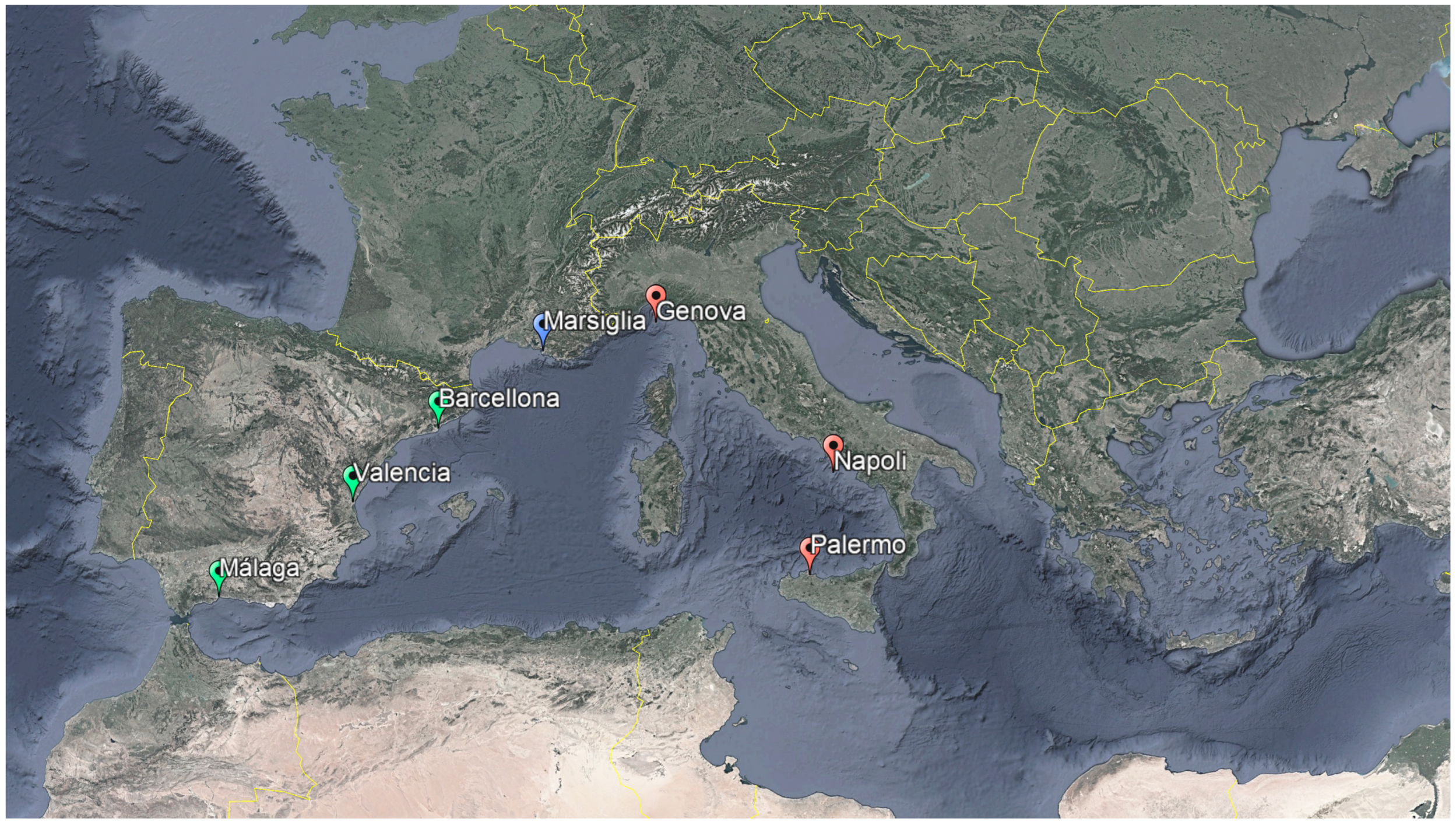
Figure 2.
The wide Prado coastal park, with large open spaces for sports and bathing and commercial functions. Behind, the green area of Parc Borély (from Wikimedia Commons, licensed under CC BY-SA 4.0, author: Hilader, 2019).
Figure 2.
The wide Prado coastal park, with large open spaces for sports and bathing and commercial functions. Behind, the green area of Parc Borély (from Wikimedia Commons, licensed under CC BY-SA 4.0, author: Hilader, 2019).
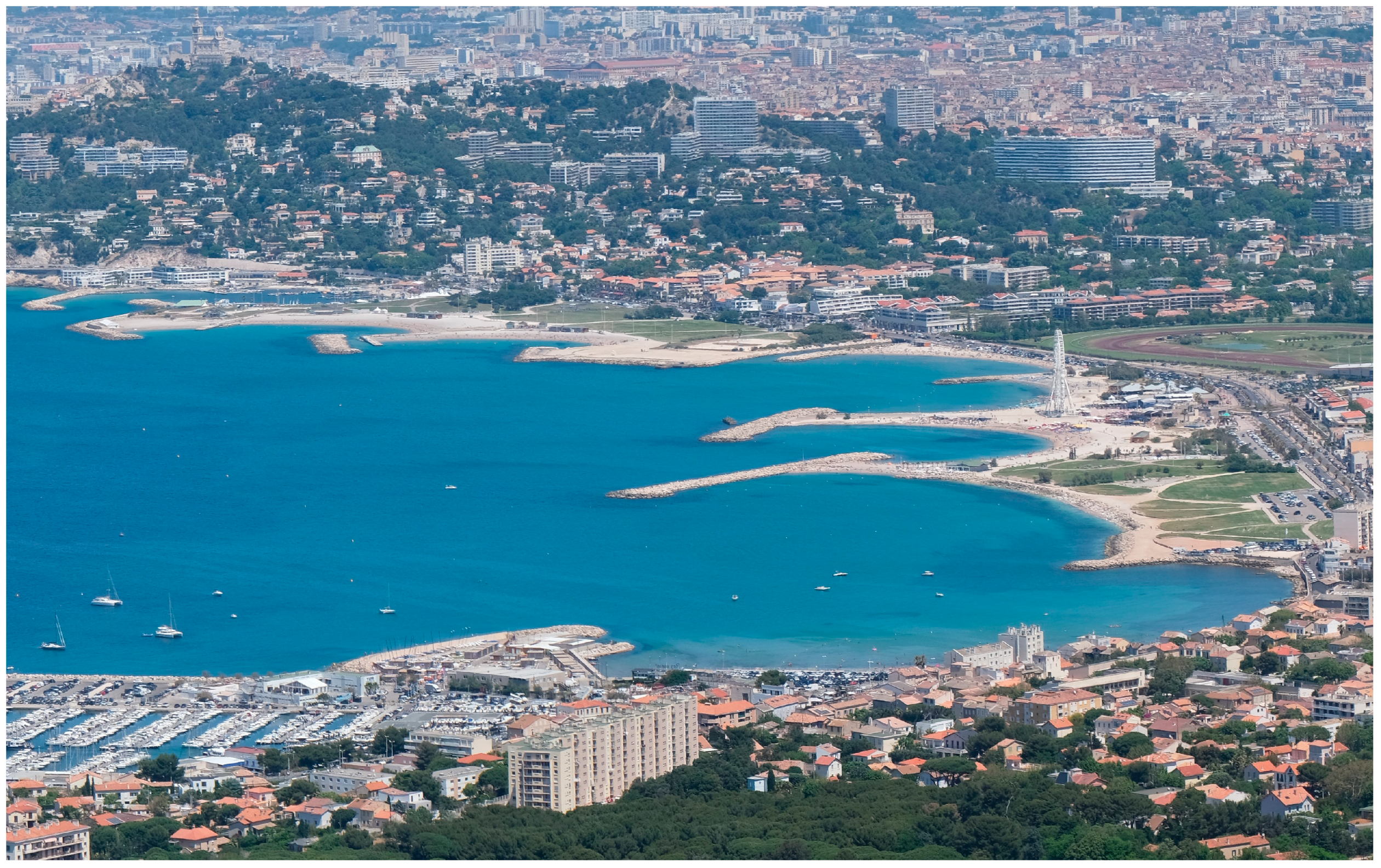
Figure 3.
Besides the bathing area, the Pointe Rouge site has a space dedicated to boat storage, connected to the adjacent homonymous tourist port. Here’s a view from the developed project for the area (source: https://ateliermira.fr/index.php/portfolio-item/pointe-rouge/).
Figure 3.
Besides the bathing area, the Pointe Rouge site has a space dedicated to boat storage, connected to the adjacent homonymous tourist port. Here’s a view from the developed project for the area (source: https://ateliermira.fr/index.php/portfolio-item/pointe-rouge/).
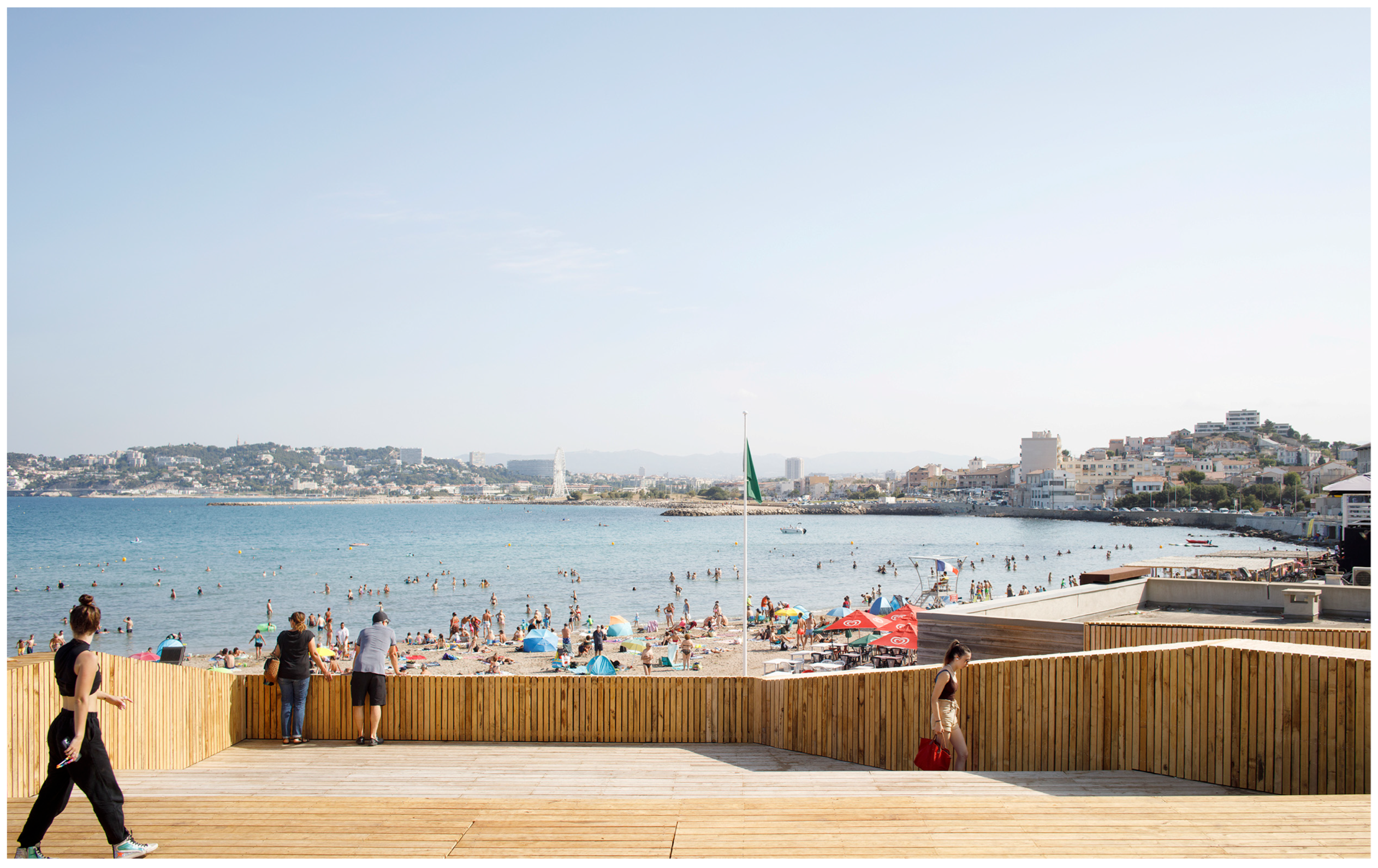
Figure 4.
Details from the regeneration project for Poitne Rouge: (a) on the left, the redesigned entrance to the beach area; (b) on the right, the new facilities for bathing and restoration services (pictures by I. Pistone, 2021).
Figure 4.
Details from the regeneration project for Poitne Rouge: (a) on the left, the redesigned entrance to the beach area; (b) on the right, the new facilities for bathing and restoration services (pictures by I. Pistone, 2021).
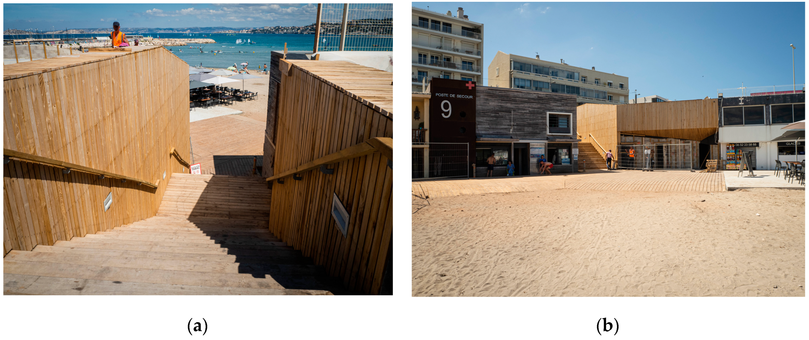
Figure 5.
Masterplan of the main coastal intervention in the Euromediterranée framework. It is clear the aim to build a littoral green infrastructure (source: https://www.euromediterranee.fr/).
Figure 5.
Masterplan of the main coastal intervention in the Euromediterranée framework. It is clear the aim to build a littoral green infrastructure (source: https://www.euromediterranee.fr/).
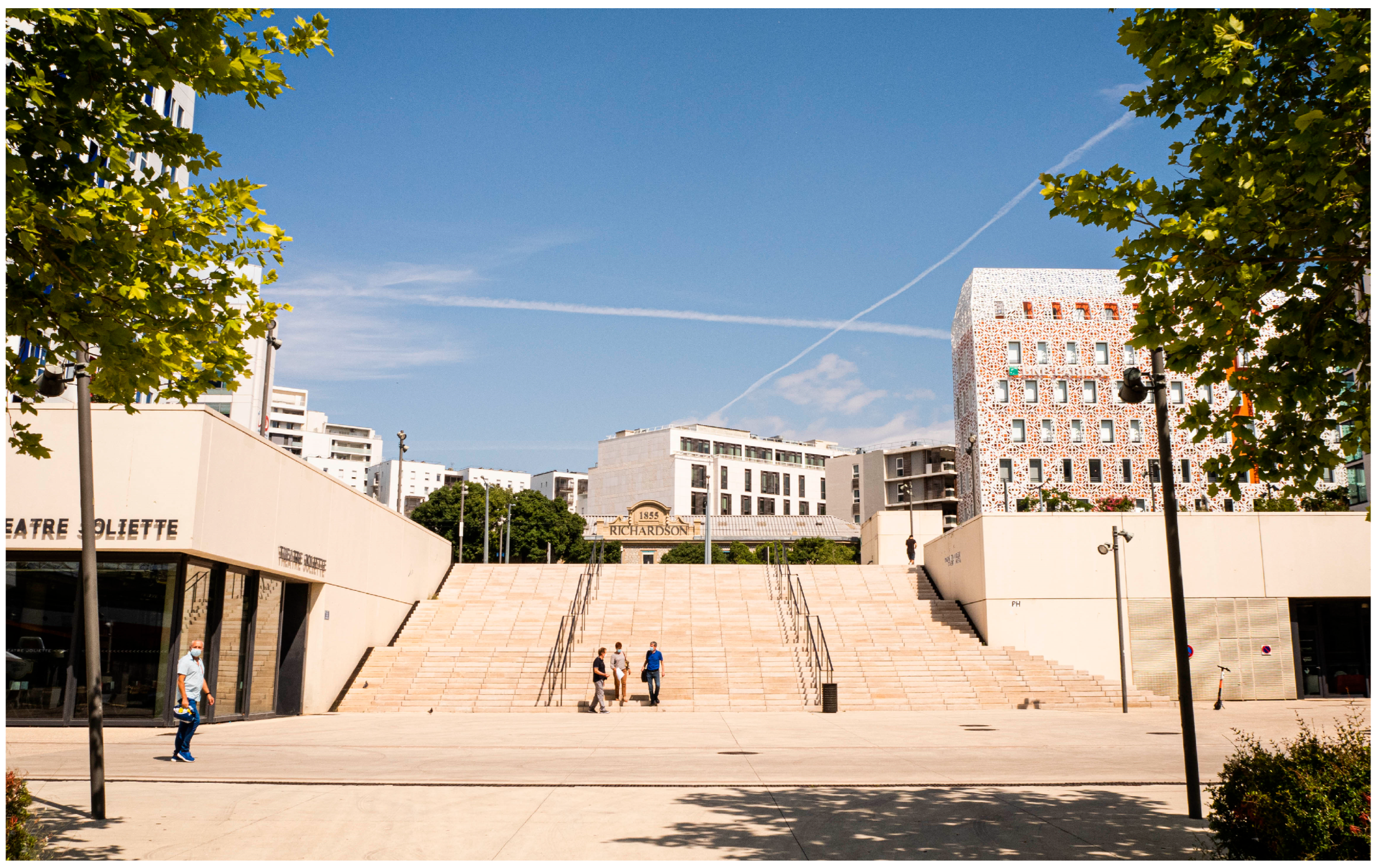
Figure 5.
Place Henri Verneuil represents an important node of the Euroméditerranée district, as it connects various accommodation, cultural and administrative functions: however, it often appears not very frequented (source: https://www.euromediterranee.fr/).
Figure 5.
Place Henri Verneuil represents an important node of the Euroméditerranée district, as it connects various accommodation, cultural and administrative functions: however, it often appears not very frequented (source: https://www.euromediterranee.fr/).
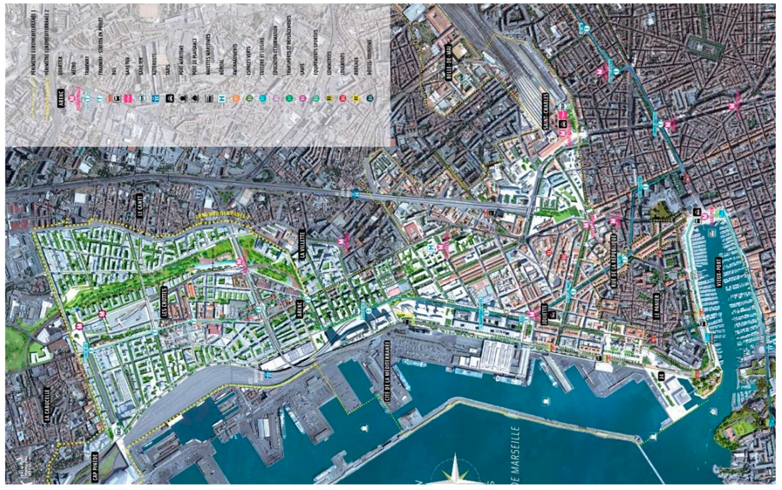
Figure 7.
The panoramic terrace that gives its name to the multifunctional center Les Terrasses du Port is freely accessible. Users usually go there to observe the cruise ships docking and the urban sea, against the background of the Euroméditerranée skyscrapers (picture by I. Pistone, 2021).
Figure 7.
The panoramic terrace that gives its name to the multifunctional center Les Terrasses du Port is freely accessible. Users usually go there to observe the cruise ships docking and the urban sea, against the background of the Euroméditerranée skyscrapers (picture by I. Pistone, 2021).
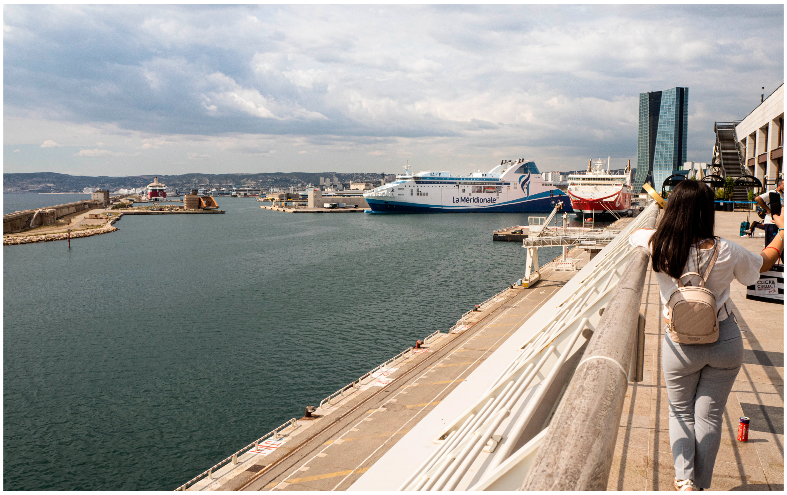
Figure 8.
The area linking the Euromediterranée and the port shows a fracture between the new district and the sea which is physically and visually unreachable (picture by I. Pistone, 2021).
Figure 8.
The area linking the Euromediterranée and the port shows a fracture between the new district and the sea which is physically and visually unreachable (picture by I. Pistone, 2021).
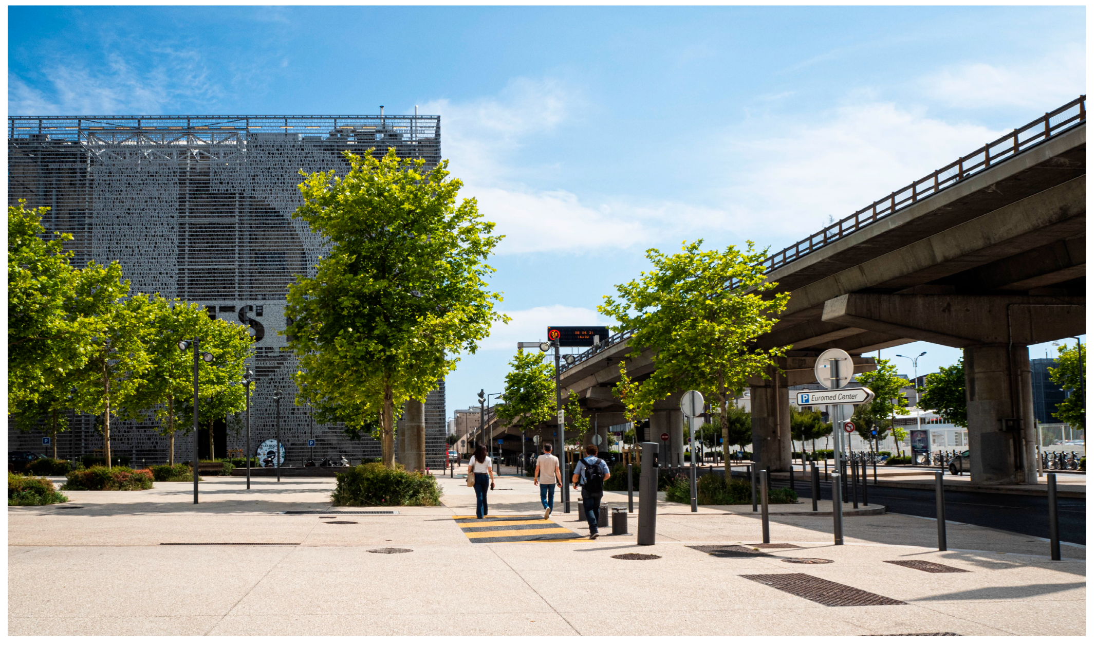
Figure 9.
Plage des Catalans is perfectly set in the urban environment, offering a space with a high frequency of visits by the inhabitants of Marseille: (a) on the left, the arcade hosted fee-based services, now closed; (b) on the right, playgrounds on the sand and the Tour Lazaret, from which a sea promenande starts (pictures by I. Pistone, 2021).
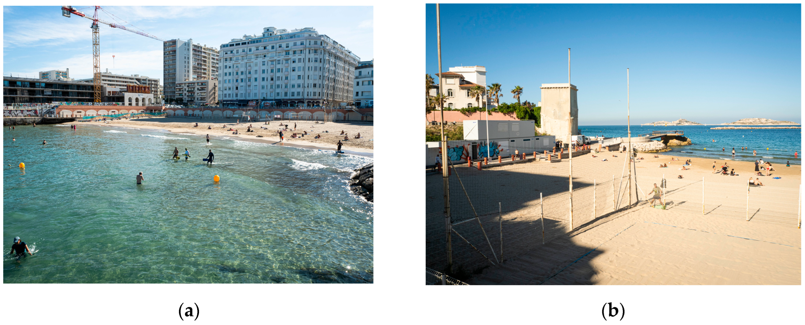
Figure 10.
One of the accesses to the Corbières bathing system. It is shown the terraced steps within the public garden: it is used as a social meeting place, although it is affected by a certain degree of neglect and denotes difficult accessibility (picture by I. Pistone, 2021).
Figure 10.
One of the accesses to the Corbières bathing system. It is shown the terraced steps within the public garden: it is used as a social meeting place, although it is affected by a certain degree of neglect and denotes difficult accessibility (picture by I. Pistone, 2021).
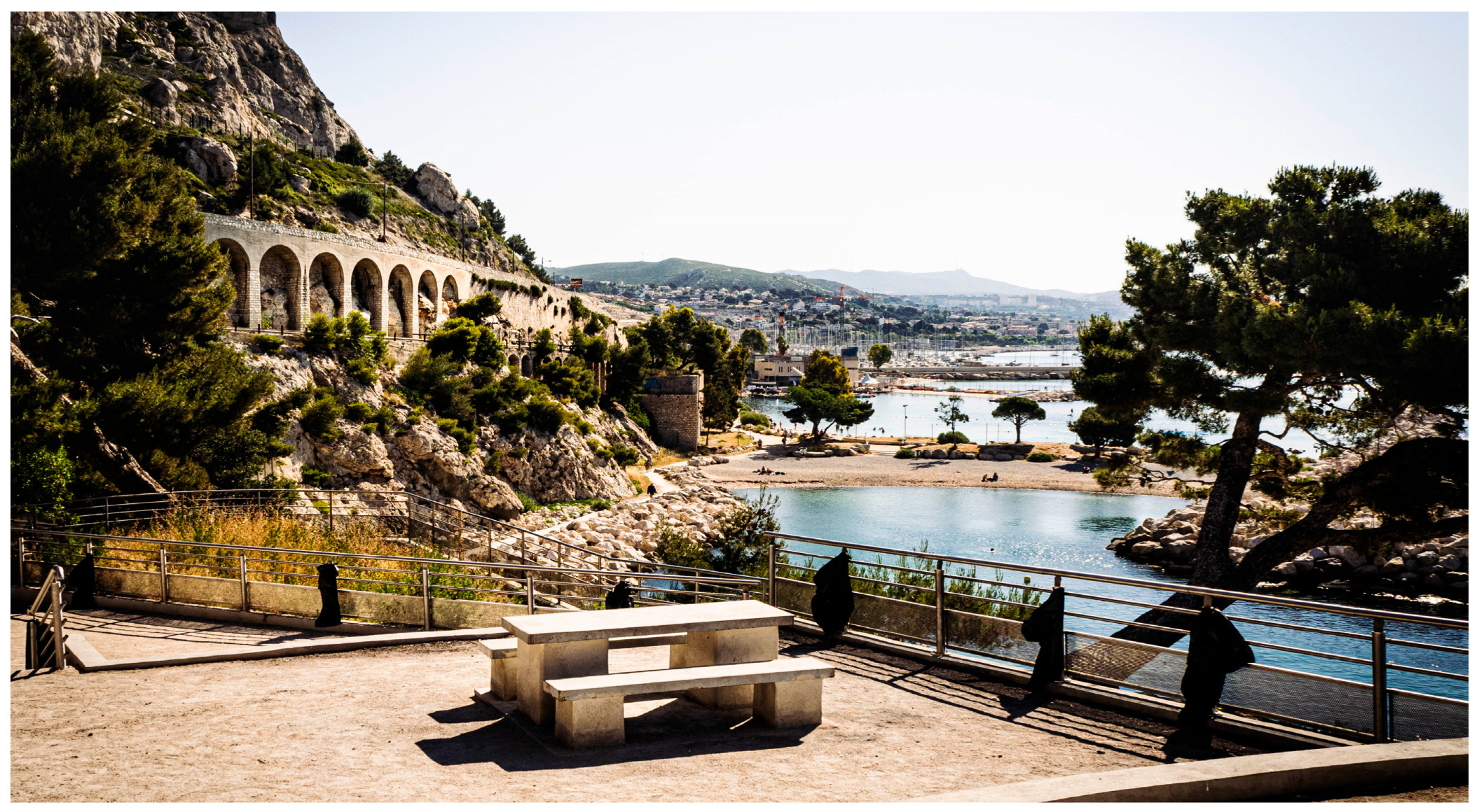
Figure 11.
(a) on the left, the coastal promenade of Passeig Maritim has the dual function of facilitating the use of the city-sea interface and connecting the Barceloneta seaside area to the city; (b) on the right, the Barceloneta beach from above (from Wikimedia Commons, licensed under CC BY 2.0).
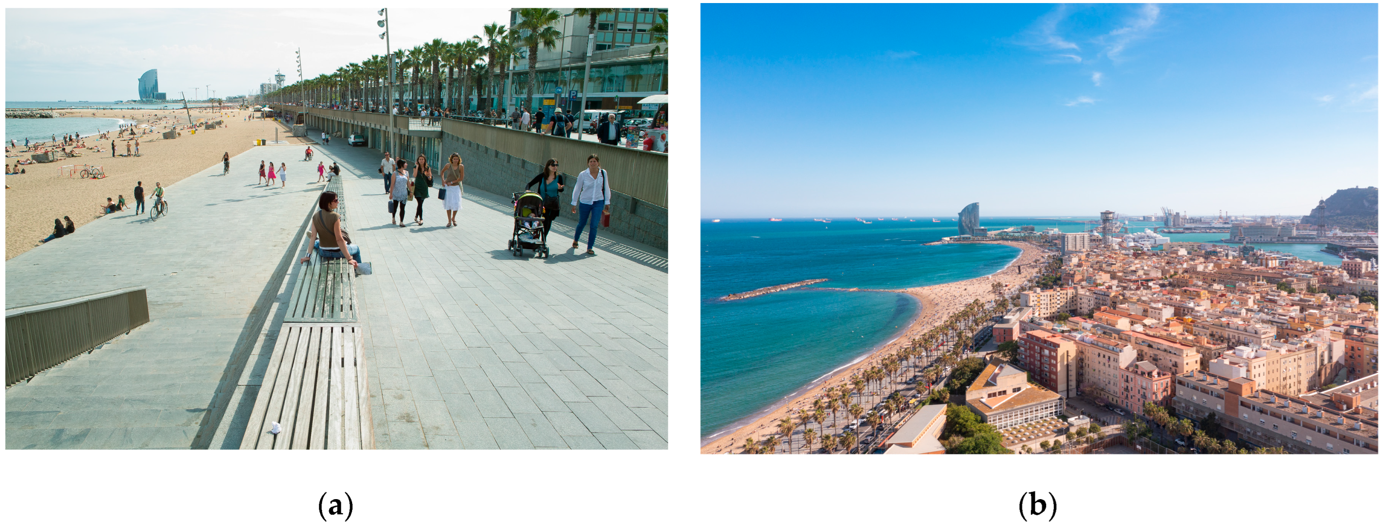
Figure 12.
The urban complex of Diagonal Mar i el Front Marítim del Poblenou takes on the features of a major transformation project linked to a great event, even without fully integrating itself on a functional level into the city system (from Wikimedia Commons, licensed under CC BY 3.0).
Figure 12.
The urban complex of Diagonal Mar i el Front Marítim del Poblenou takes on the features of a major transformation project linked to a great event, even without fully integrating itself on a functional level into the city system (from Wikimedia Commons, licensed under CC BY 3.0).
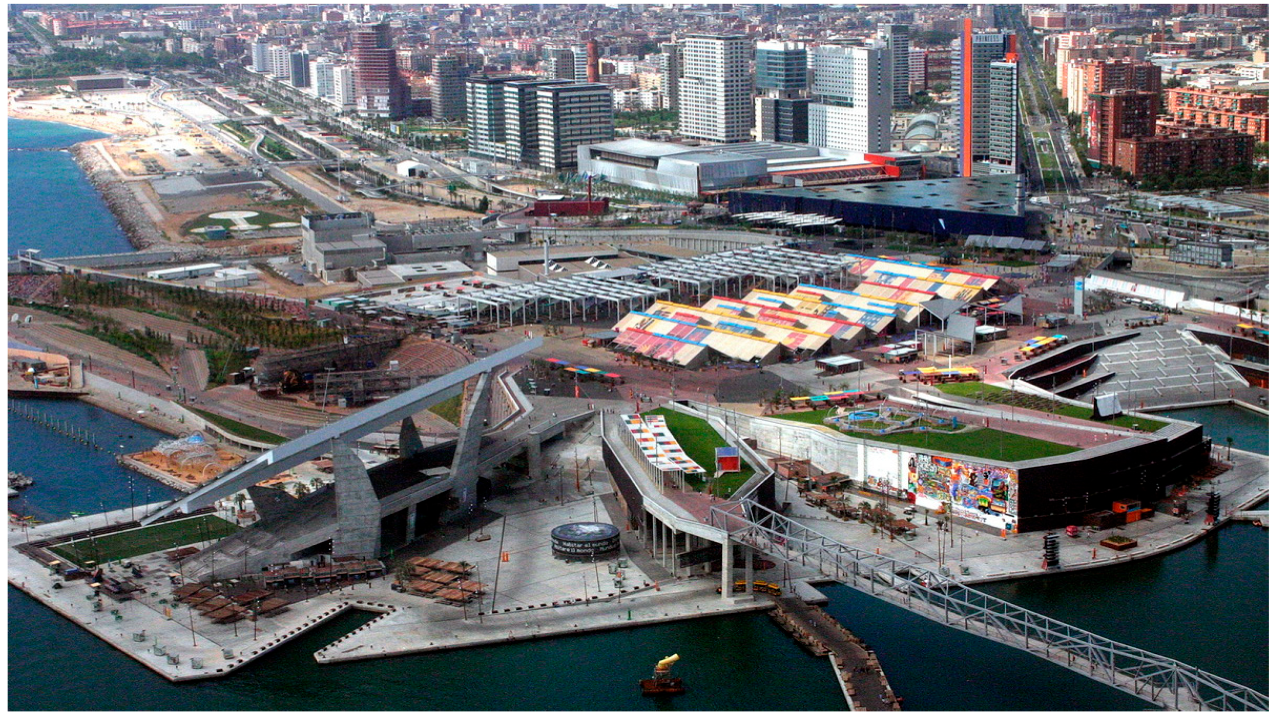
Figure 13.
The Marina Real Juan Carlos I follows the Valencian coastal profile, offering the possibility for users to get in touch with the sea resource (source: www.comunitatvalenciana.com).
Figure 13.
The Marina Real Juan Carlos I follows the Valencian coastal profile, offering the possibility for users to get in touch with the sea resource (source: www.comunitatvalenciana.com).
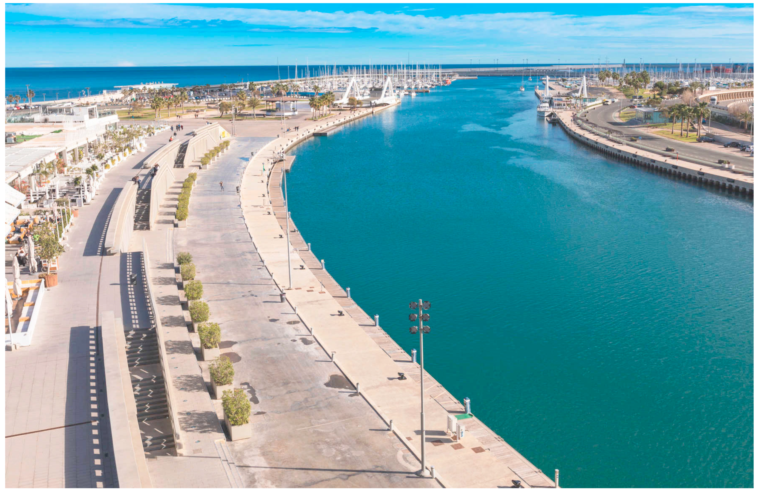
Figure 14.
The proposal from Atelier Jean Nouvel for the development of the Marina: in red, the draft highlights new built area, c while a sinuous green corridor accompanies users towards the sea (source: https://www.jeannouvel.com/en/projects/valencia-littoral/).
Figure 14.
The proposal from Atelier Jean Nouvel for the development of the Marina: in red, the draft highlights new built area, c while a sinuous green corridor accompanies users towards the sea (source: https://www.jeannouvel.com/en/projects/valencia-littoral/).
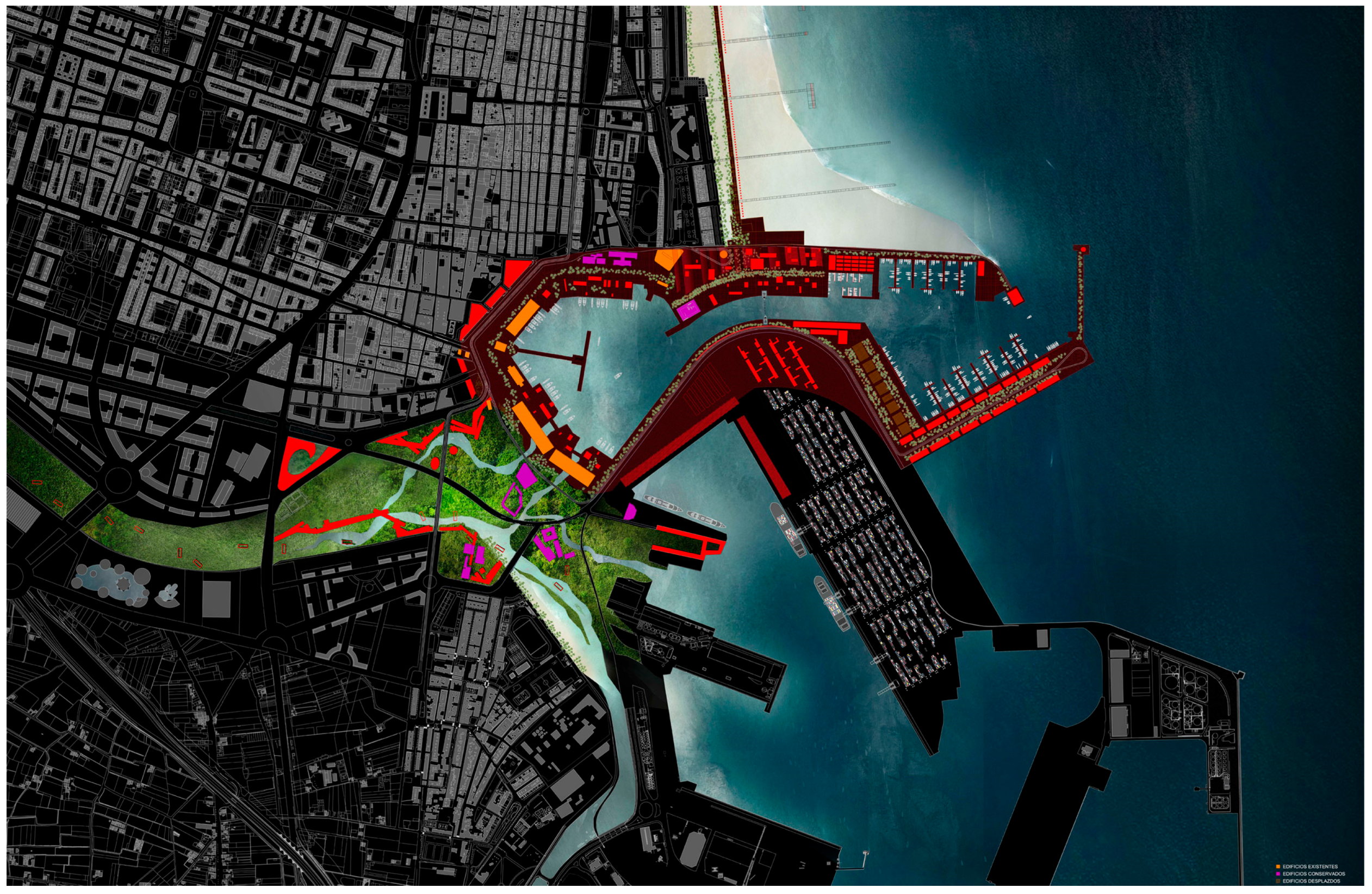
Figure 15.
The pocket beaches system in the Pedralejo area, with its characteristic artificial reefs that help preserve the strips of coastal land used for bathing. On the left, The beach in the Baños del Carmen area, with its old thermal building. To date, this infrastructure is used for recreational and cultural purposes (source: Google Earth).
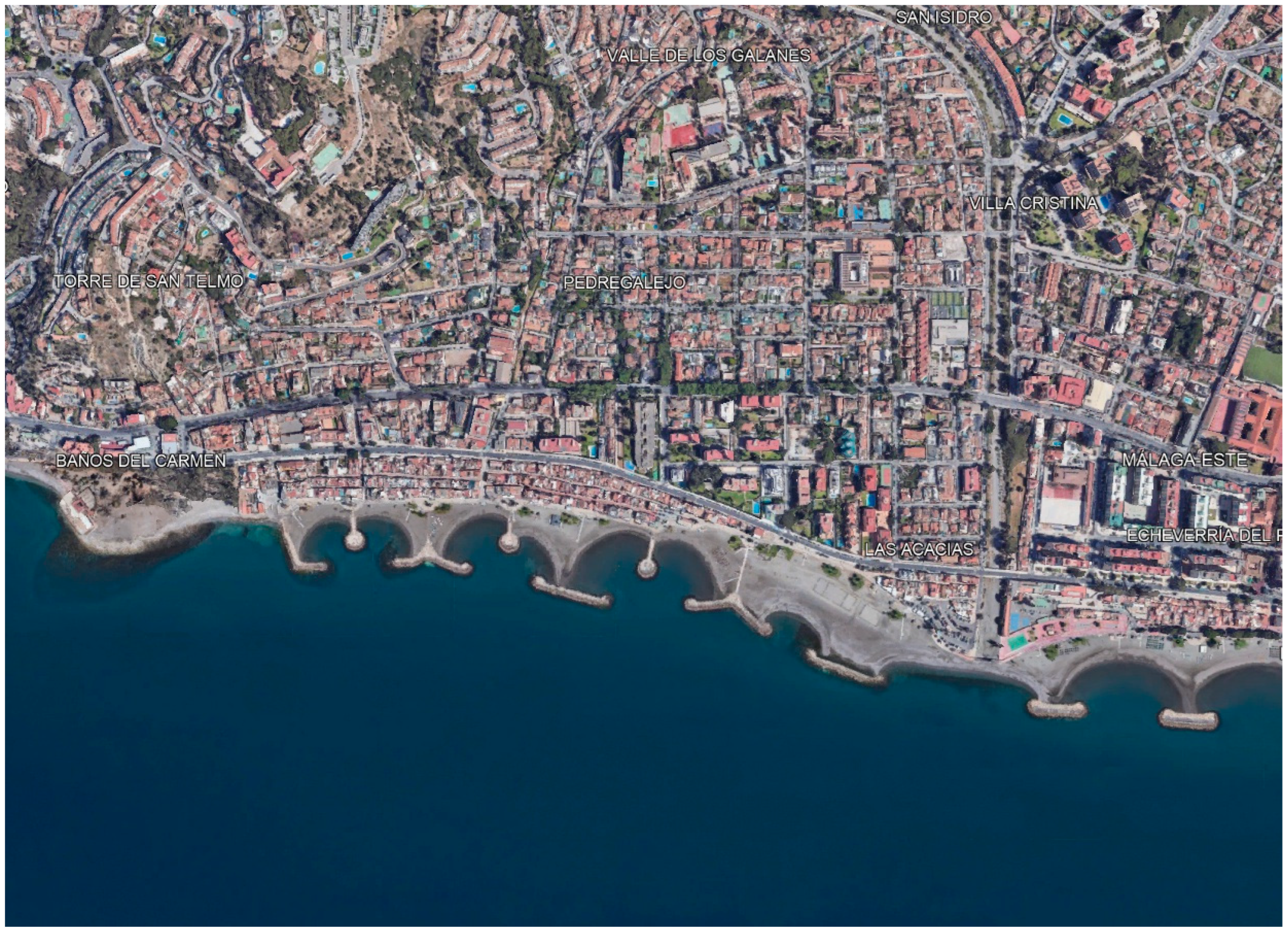
Figure 16.
Calatrava's harbour defines the pedestrian space of Palmeral de las Sorpresas along the coast of Malaga, bordering both the sea and the adjacent urban green area of the Parque de Malaga (on the left) (source: https://arquitecturaviva.com/).
Figure 16.
Calatrava's harbour defines the pedestrian space of Palmeral de las Sorpresas along the coast of Malaga, bordering both the sea and the adjacent urban green area of the Parque de Malaga (on the left) (source: https://arquitecturaviva.com/).
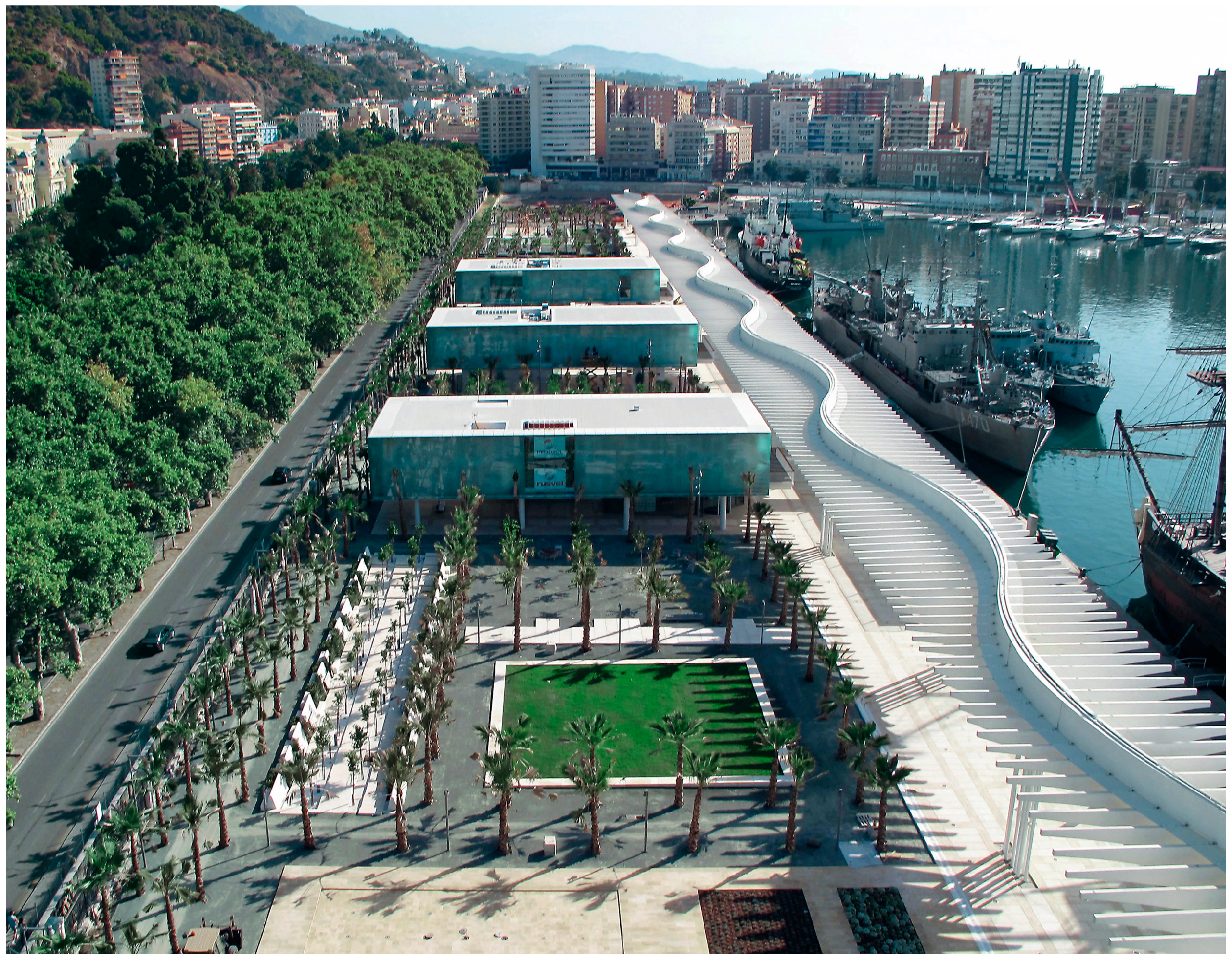
Figure 17.
One of the new public spaces envisaged for the filtering line between the port infrastructure and the urban area along the coastal interface of Naples, proposing a juxtaposition between logistic and social uses of the coast (source: https://arquitecturaviva.com/).
Figure 17.
One of the new public spaces envisaged for the filtering line between the port infrastructure and the urban area along the coastal interface of Naples, proposing a juxtaposition between logistic and social uses of the coast (source: https://arquitecturaviva.com/).
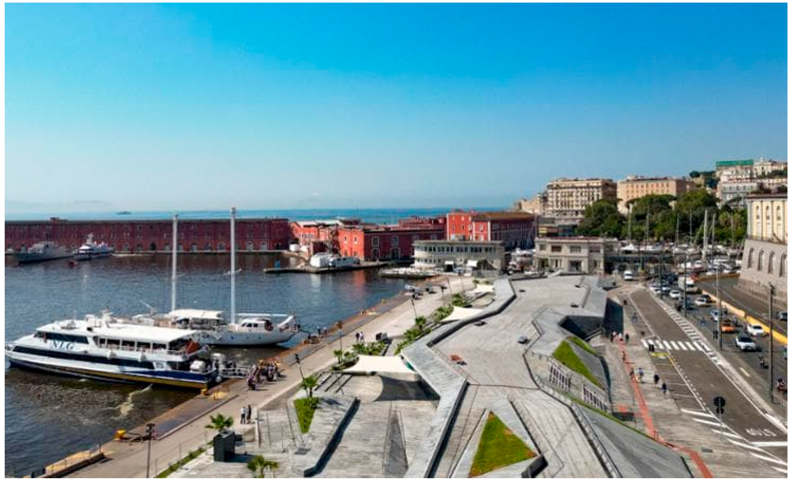
Figure 18.
Aerial view of the winning project of the call the transformation of the former productive area. There is an intention to create a vast urban park and to work on the contact with the sea, sacrificing the local scale of intervention (source: https://www.invitalia.it/).
Figure 18.
Aerial view of the winning project of the call the transformation of the former productive area. There is an intention to create a vast urban park and to work on the contact with the sea, sacrificing the local scale of intervention (source: https://www.invitalia.it/).
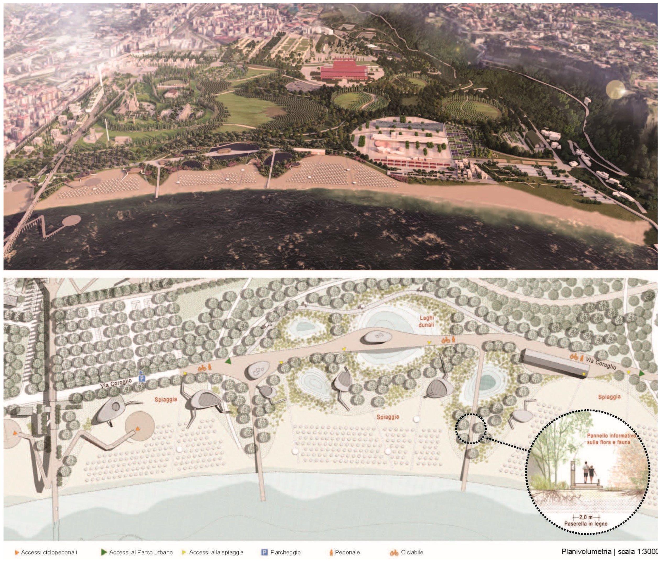
Figure 19.
Masterplan of the port of Palermo, identifying areas for sport and leisure activities (in purple and light blue), an area with high landscape-ecological value (in green) and an area dedicated to the specific connection between city and sea (in grey) (source: www.adsppalermo.it).
Figure 19.
Masterplan of the port of Palermo, identifying areas for sport and leisure activities (in purple and light blue), an area with high landscape-ecological value (in green) and an area dedicated to the specific connection between city and sea (in grey) (source: www.adsppalermo.it).
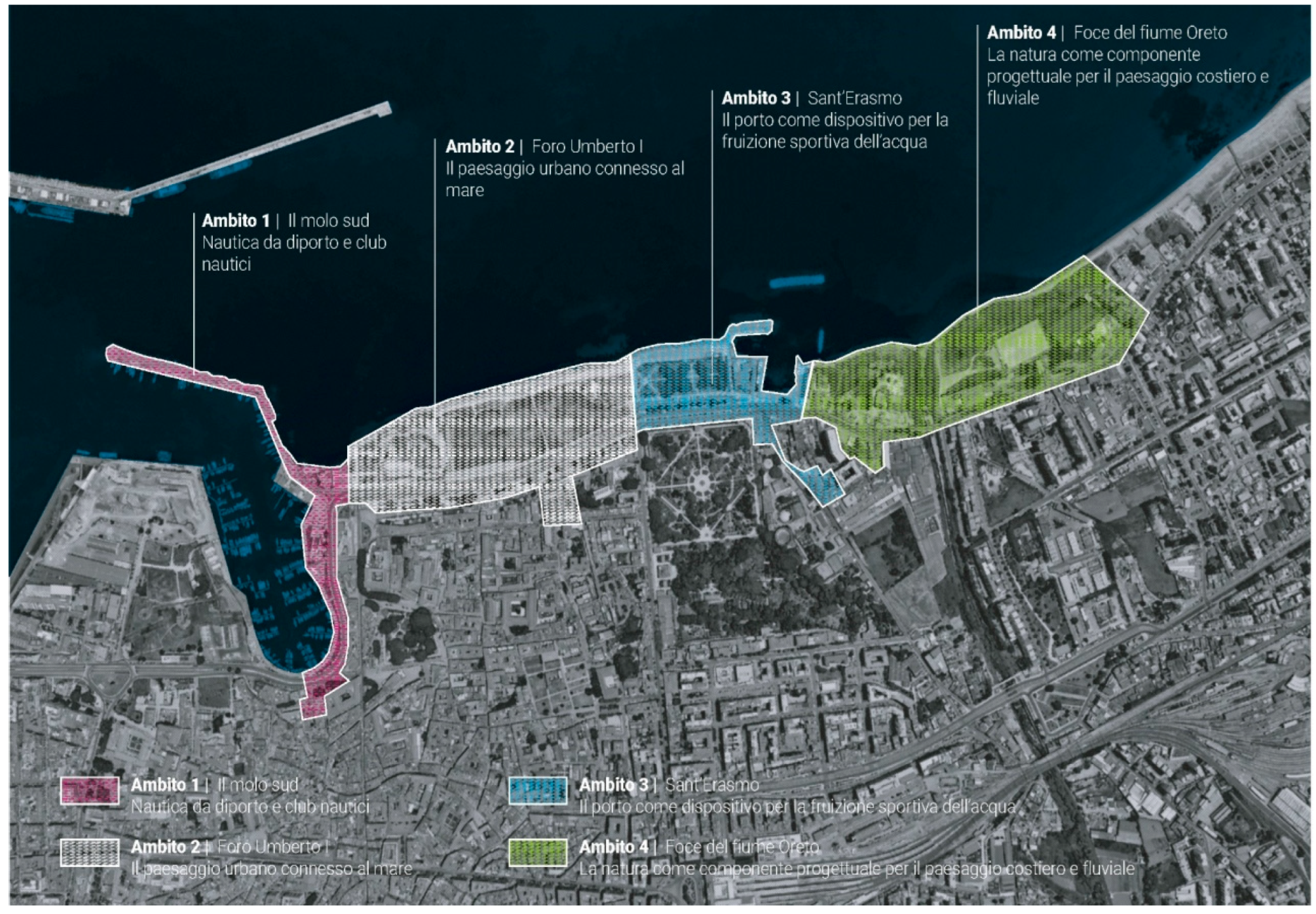
Figure 20.
Detail of the transformation project of the Palermo coastal interface as a connection between the port and the city, through the implementation of architectural quality and the creation of green spaces (source: www.adsppalermo.it).
Figure 20.
Detail of the transformation project of the Palermo coastal interface as a connection between the port and the city, through the implementation of architectural quality and the creation of green spaces (source: www.adsppalermo.it).
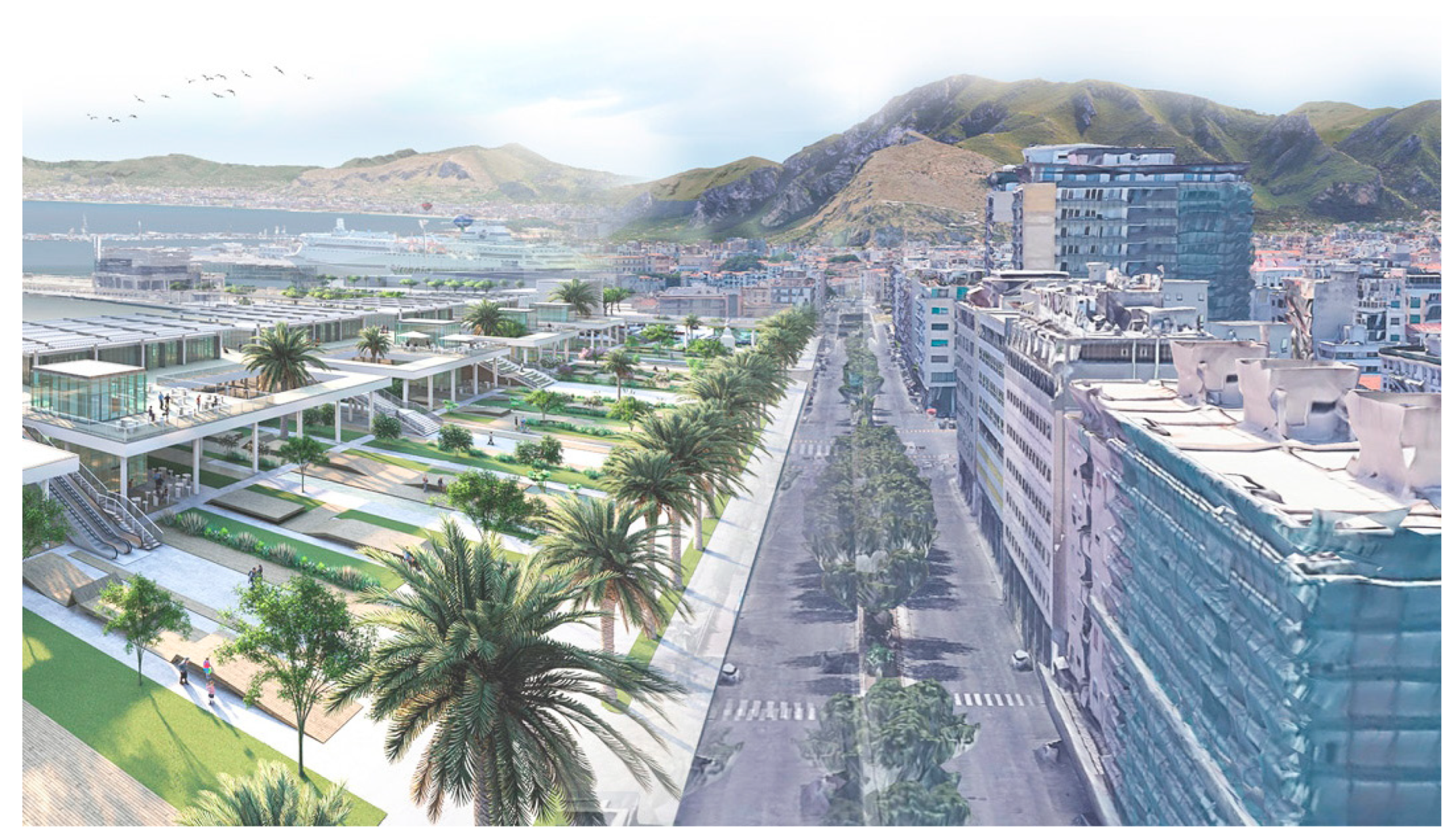
Figure 21.
The operations on the Porto Antico in Genoa have remodeled the harbour area of the city-sea interface through the creation of public spaces and some landmark buildings. (from Wikimedia Commons, licensed under CC BY-SA 3.0, author: A. Sbarbaro).
Figure 21.
The operations on the Porto Antico in Genoa have remodeled the harbour area of the city-sea interface through the creation of public spaces and some landmark buildings. (from Wikimedia Commons, licensed under CC BY-SA 3.0, author: A. Sbarbaro).
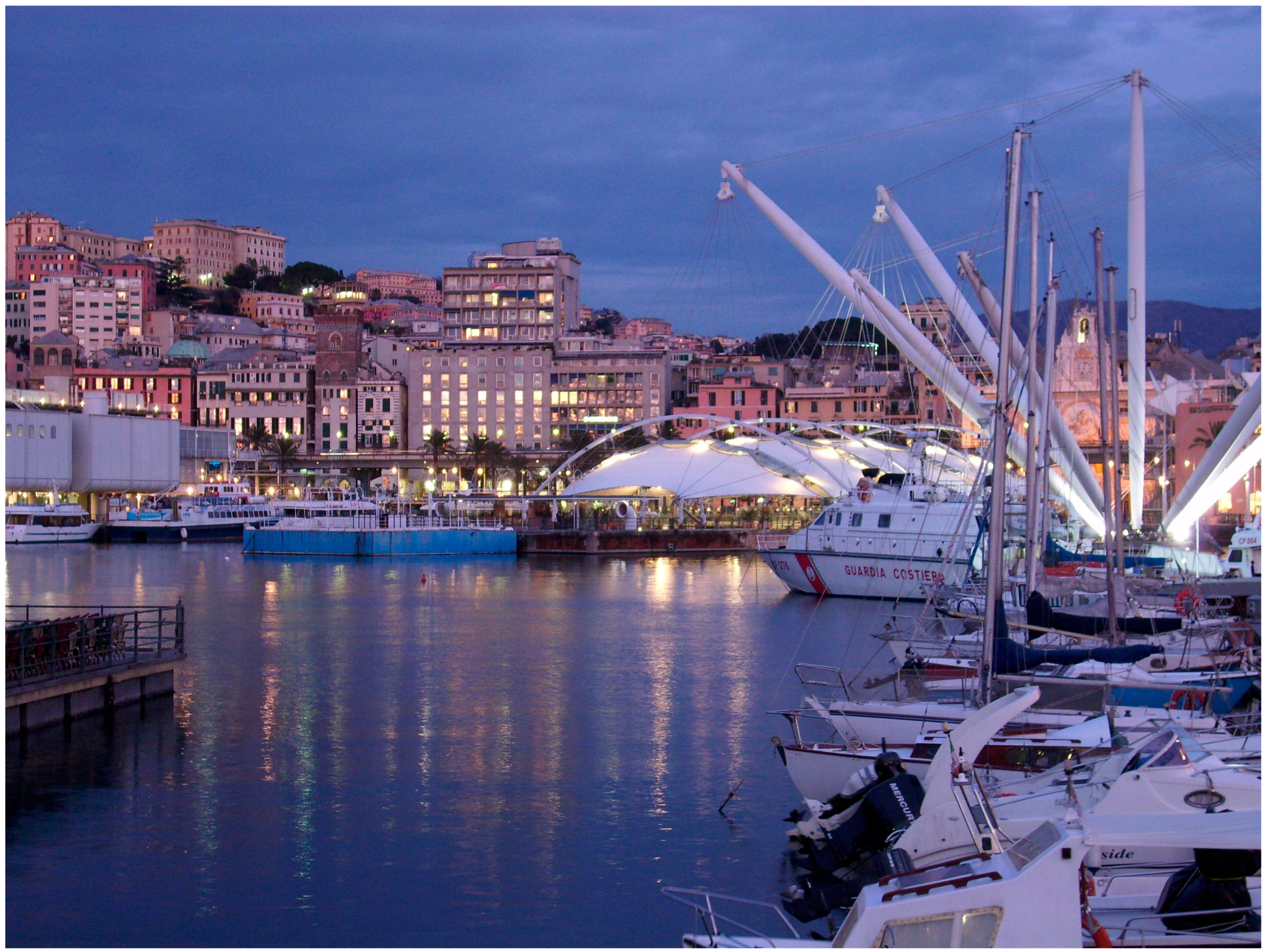
Figure 22.
The Parco delle Dune and the pedestrian walkway of Genova-Prà fits into the urban context as an environmental and noise filtering element between the port infrastructure and the sea (source: https://www.portsofgenoa.com/).
Figure 22.
The Parco delle Dune and the pedestrian walkway of Genova-Prà fits into the urban context as an environmental and noise filtering element between the port infrastructure and the sea (source: https://www.portsofgenoa.com/).
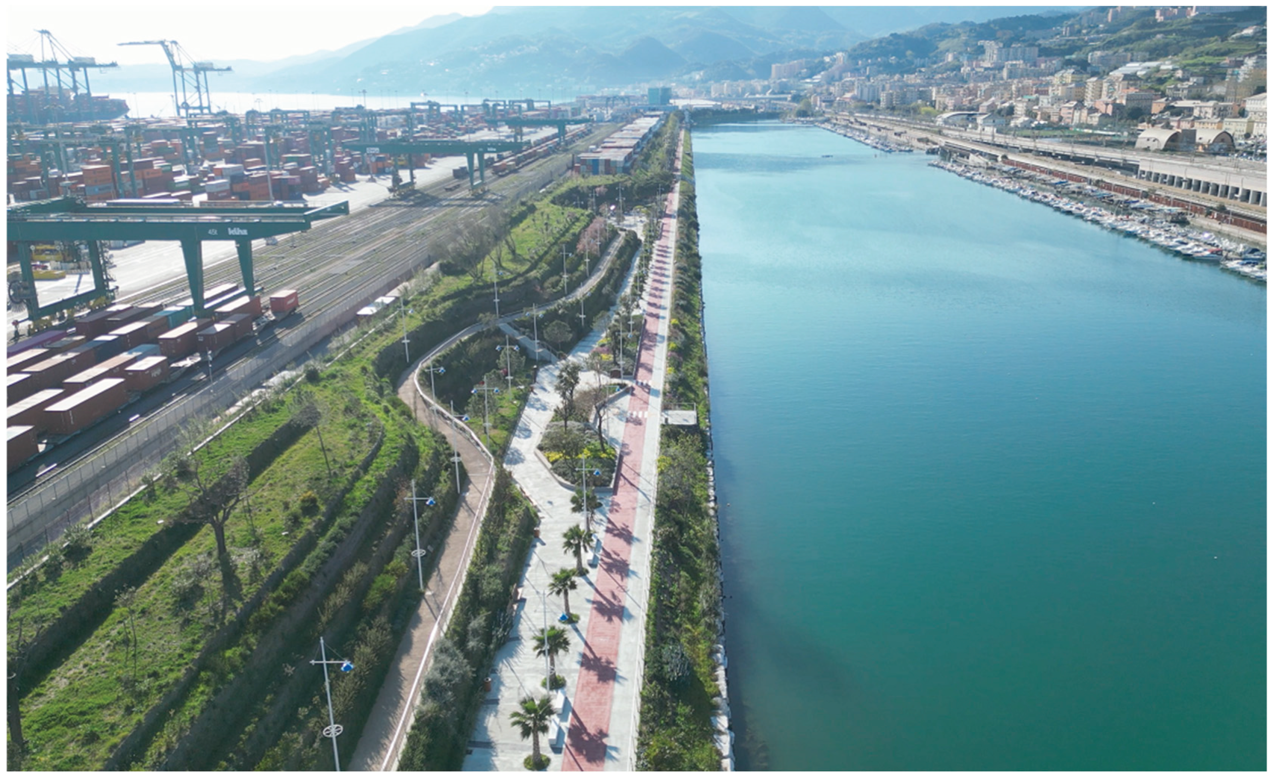
Figure 23.
Benchmarking among the main cathegories of intervention for the regeneration of coastal public spaces (elaboration of I. Pistone).
Figure 23.
Benchmarking among the main cathegories of intervention for the regeneration of coastal public spaces (elaboration of I. Pistone).
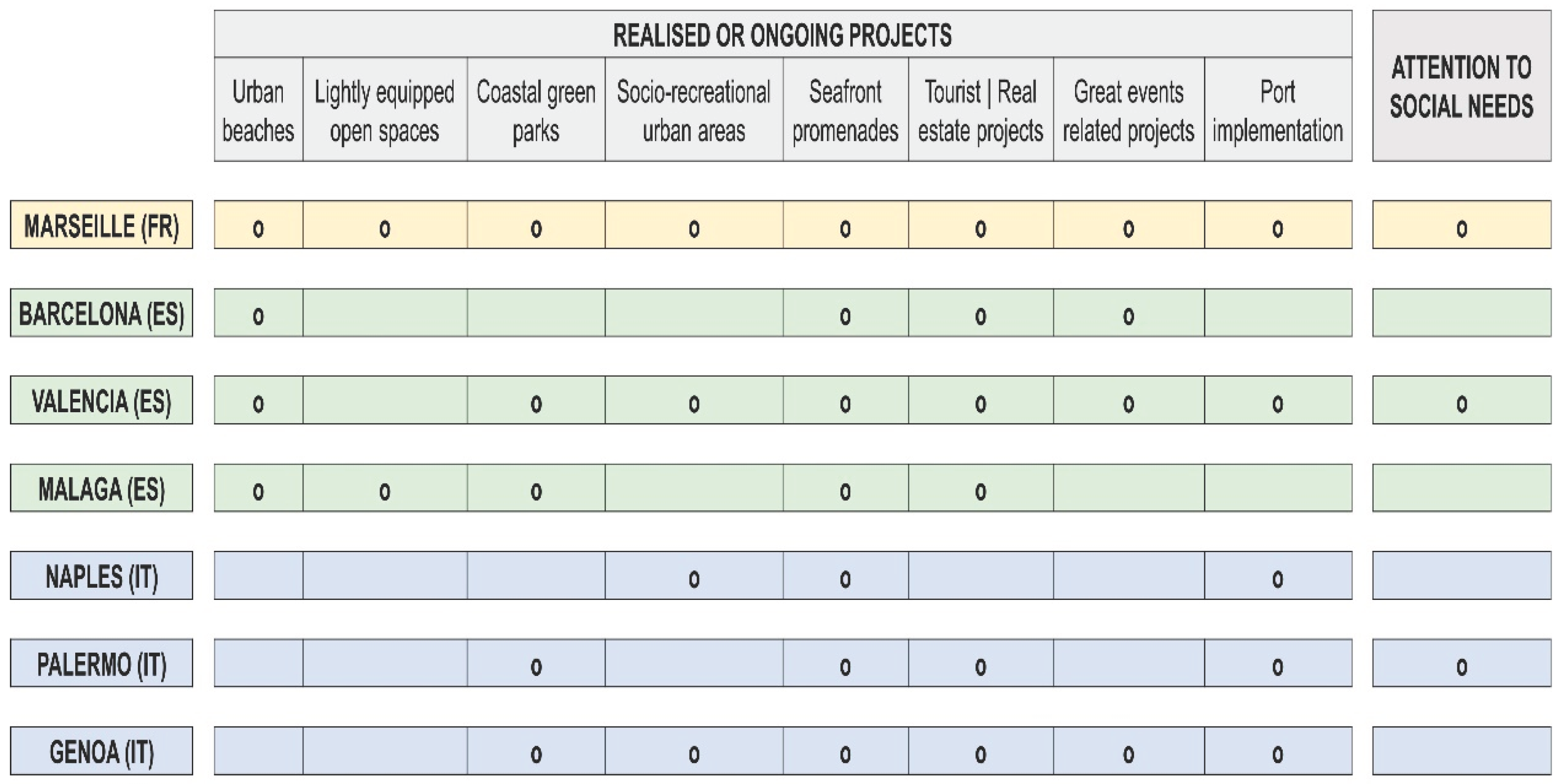
Disclaimer/Publisher’s Note: The statements, opinions and data contained in all publications are solely those of the individual author(s) and contributor(s) and not of MDPI and/or the editor(s). MDPI and/or the editor(s) disclaim responsibility for any injury to people or property resulting from any ideas, methods, instructions or products referred to in the content. |
© 2025 by the authors. Licensee MDPI, Basel, Switzerland. This article is an open access article distributed under the terms and conditions of the Creative Commons Attribution (CC BY) license (http://creativecommons.org/licenses/by/4.0/).
Copyright: This open access article is published under a Creative Commons CC BY 4.0 license, which permit the free download, distribution, and reuse, provided that the author and preprint are cited in any reuse.


