
Submitted:
07 June 2025
Posted:
10 June 2025
You are already at the latest version
Abstract
Understanding forest cover change and its drivers is vital for global forest management and policy development. This study analysed perceptions of historical drivers behind land use land cover change (LULCC) and forest change in gazetted forests from 1966 to 2020 and evaluated the human activities around the gazetted forest reserves, comparing three forests in Nasarawa State, North Central Nigeria. Data were collected through questionnaires, interviews, and focus group discussions. Three gazetted forests were sampled to represent the three senatorial districts of the state. SPSS, NVivo, and Python 3 were used for data analyses to generate statistics and code themes. Results show that changes were perceived to be triggered by sixteen drivers (direct and indirect) related to social, economic, environmental, policy/institutional, and technological elements. Agricultural expansion, lumbering, and charcoal production were the most reported direct drivers, while population growth, poverty, and government policies were the most perceived indirect drivers. The results showed variations in human activities across forest sites. For example, agricultural expansion, lumbering, and grazing were more widespread while construction and settlement activities differed between forests. Risha saw agriculture expansion ahead of other drivers, Doma saw population growth above other drivers, and Odu saw lumbering aiding other drivers that led to change. Implementation of policies focusing on these key drivers must match local priorities to engage people in forest conservation. These efforts could ensure effective forest protection that is vital for achieving global biodiversity and climate targets and safeguarding local livelihoods. The specific drivers of changes in each forest need to be targeted in conservation efforts.
Keywords:
land use driver
; gazetted forest reserves
; local perceptions
; forest conservation policy
; human-environment interaction
; Nigeria-Africa
1. Introduction
Human-caused alterations of the Earth's surface frequently lead to the destruction of forests and woodlands, as well as the degradation of forested areas [1,2,3]. The primary issues around forest conservation and livelihood change issues are attributed to land use and human interactions [4,5,6]. These human activities are linked to deforestation and forest degradation which work against the protection of forests and their management systems [7,8]. Assessing these are vital for effective local, regional, and global development of environmental settings [9,10]. The impact of land use change and the factors that drive it have been shown to affect forest cover and biodiversity negatively, which has important implications as biodiversity sustains the livelihoods that people depend on to survive [11,12,13].
It is important to evaluate drivers that contribute to changes and degradation in forest cover and protect areas from the local perspective [10,14]. This approach ensures that interventions are relevant to the specific context, garner community support, address root causes, and adapt to changing conditions, ultimately leading to better outcomes for both forests and the local people who depend on them, often directly, for their livelihoods [15,16]. Incorporating a local perspective enables the consideration of both environmental and human aspects of forest management. Forests play a crucial role as a valuable resource, providing a diverse array of ecosystem services, including timber, food, fuel, and non-timber bioproducts [17]. Additionally, they contribute to the maintenance of ecological functions, including carbon storage, nutrient cycling, water and air purification, and the preservation of wildlife habitat; services that are essential for promoting human well-being and supporting life [18,19,20]. Human activities have led to a 60% decrease in ecosystem services globally, according to the Millennium Ecosystem Assessment [21], reiterated by [14,22]. As the primary means of subsistence for people living in poverty, they rely heavily on these services, so often lose the most in terms of ecosystem service losses [23,24,25].
According to the Millennium Ecosystem Assessment [21], when a driver has an evident influence, it is referred to as a "direct driver". When it underlies or leads to a "direct driver," it is referred to as an "indirect" (underlying) driver. Direct drivers have a clear and straightforward cause-and-effect relationship with the observed changes. They comprise activities or actions that directly affect forest cover and land use, such as agriculture, urban expansion, mining, logging, livestock grazing, and forest fires, among others [2,26,27]. Indirect drivers encompass complex political, socio-economic, cultural, and technological interactions [13,28,29]. Further indirect drivers contributing to deforestation include corruption, inadequate governance, population growth, climate change, and ambiguous land tenure arrangements [15,30,31]. According to Geist and Lambin [32] and the Millennium Ecosystem Assessment [21] indicate that changes in these drivers influence not only the land cover but also change the forest although the drivers and their impacts differ regionally.
In most developing nations of Latin America, Asia, and Africa, the key driver of deforestation is the conversion of forest land to agriculture (commercial and subsistence) linked to activities such as logging, charcoal, collecting fuelwood and forest fires and livestock grazing [10,33,34].
In Nigeria, research has been conducted on LULCC, and the drivers of it using remote sensing and survey data [35,36,37], but there has been limited research on the current drivers of protected and forest reserves changes, particularly in North Central Nigeria [35,38,39]. Although remote sensing data and GIS applications have been used in quantifying the extent of changes in land use and forest change in many regions [40,41,42,43], it cannot explain the rationale behind the anthropogenic drivers that are felt or perceived by the stakeholders in the forest communities. Understanding perceptions is important as it affects how people behave and their attitudes towards the forest. Gaining this understanding demands quantitative and qualitative approaches for detailed understanding beyond just the observation of the change. This paper aims to evaluate the perceived drivers of forest change using an empirical perspective at the local community level including those populations living close to the gazetted forest reserves. The study assesses the socio-economic activities in the gazetted forest-dependent community, evaluates direct and indirect drivers that influence the gazetted forest reserves change and compares the drivers and human activities across the three forest regions in the state.
2. Research Design and Methods
This section describes the geographical setting of the research area, the methods used, procedures employed, and the techniques used to gather and analyse data. This study was carried out in Nasarawa State (Figure 1).
The choice to carry out this research in Nigeria was driven by its strategic position in the West African Guinea savanna region (Figure 1), which is renowned for its economy based on natural resources and rich biodiversity [44]. Nasarawa State, located in North Central Nigeria within the Guinea savanna zone, was selected due to migration caused by conflicts between farmers and herders, prompting people to seek safety and livelihoods in Nasarawa State [45,46,47,48]. This influx has enhanced Nasarawa's reputation as a significant national food producer, supporting a variety of food and cash crops and drawing individuals in search of sustainable livelihoods [49,50]. As observed worldwide, the expansion of farmland is the leading cause of deforestation [51]. The state exhibits characteristics of both Southern and Northern Guinea, with Northern Guinea grass species resembling those of the southern region, featuring grasslands and woody shrubs [52,53]. This vegetation is subjected to annual fires caused by human activity [54,55], with species such as Parkia biglobosa (African locust bean tree), Vitellaria paradoxa (Shea butter tree), Milicia excelsa (Iroko tree) Burkea africana (wild syringa), Anogeisses leiocarpa (African, birch satin wood) Afromosia, (African teak) are resistant to fire [55,56]. Additionally, the area's vegetation has evolved over centuries due to selective tree harvesting based on their utility to the local population and ongoing fire damage [35,54], with trees developing long taproots and thick bark for survival [55,57].
Nasarawa State receives between 1100 and 2000mm of annual rainfall, with moderate to heavy precipitation during the wet season supporting agriculture and vegetation [52,54,57]. The dry season, spanning from November to March, brings lower humidity, higher temperatures, and Harmattan winds that affect temperature and visibility [57]. The vegetation and climate of Nasarawa State shape agricultural practices, with land use ranging from agricultural to urban. Agriculture is the primary economic activity, with land allocated for crops and livestock. The communities engage in subsistence farming reliant on seasonal rainfall [29]. The state's fertile soils and climate support crops such as yams, maize, rice, and cassava, even within designated forest reserves [35,58].
Nasarawa State is home to 41 officially recognized forest reserves (Figure 2), which were established and charted in 1966 with legal documentation, although some were proposed without complete legal authorization [59]. Due to varying years of official recognition, not all were mapped. These reserves are distributed across the Nasarawa North, South, and West Senatorial districts (Figure 2.1), with the majority located in the southern region, followed by the northern and western areas. They were officially recognized under the Benue Plateau State of Nigeria gazetted supplement part B to N.R gazetted No.8 vol. 2, 1966. While local residents were prohibited from clearing vegetation, forest communities retained the right to access resources while maintaining the forest cover. They could gather water, thatching grass, dead wood, stones, fruits, and medicinal plants important to their culture. However, resource extraction was restricted to personal domestic use and not for commercial purposes, ensuring no harm to the vegetation cover [59]. Three forests- Doma, Risha, and Odu were chosen to represent each geopolitical zone: Doma in the south, Risha in the north, and Odu in the west (Figure 2). This selection ensures a comprehensive approach by encompassing ecological zones, cultural landscapes, and socioeconomic activities. Doma Forest is characterized by rich biodiversity, tropical trees, and wildlife. It holds cultural importance for indigenous communities engaged in traditional farming and fishing, with riverine and lowland forests bolstering local economies (55, 35). The community is ethnically diverse, with the Alago-speaking tribe being predominant. Risha Forest, located in the northern study area, serves as a transition between savanna and woodland ecosystems. It supports agricultural and grazing activities for pastoralist communities and acts as a barrier against desertification, sustaining local economies [35,54]. The Mada ethnic group is predominant in this area, although other groups are also present.
Nasarawa State is home to 41 officially recognized forest reserves (Figure 2), which were established and charted in 1966 with legal documentation, although some were proposed without complete legal authorization [59]. Due to varying years of official recognition, not all were mapped. These reserves are distributed across the Nasarawa North, South, and West Senatorial districts (Figure 1 and Figure 2), with the majority located in the southern region, followed by the northern and western areas. They were officially recognized under the Benue Plateau State of Nigeria gazetted supplement part B to N.R gazetted No.8 vol. 2, 1966. While local residents were prohibited from clearing vegetation, forest communities retained the right to access resources while maintaining the forest cover. They could gather water, thatching grass, dead wood, stones, fruits, and medicinal plants important to their culture. However, resource extraction was restricted to personal domestic use and not for commercial purposes, ensuring no harm to the vegetation cover [59]. Three forests- Doma, Risha, and Odu were chosen to represent each geopolitical zone: Doma in the south, Risha in the north, and Odu in the west (Figure 2). This selection ensures a comprehensive approach by encompassing ecological zones, cultural landscapes, and socioeconomic activities. The selected process also considered ecological similarity, cultural significance, and geographic distribution, representing various ecological zones and forest types of different sizes with comparable biodiversity [35,54,55].
Figure 2 illustrate the 1966 forest boundaries for the state, and the selection of forest sites took into account security threats, including kidnapping, farmer-herdsmen conflicts, inter-community crises, and cultural barriers. Prior to field visits, consultations were held with the Nigeria security services at the state divisional headquarters in Lafia, the capital of Nasarawa State, to obtain relevant security information before travelling to the area, making our final selections and data collection.
2.1. Data Source and Methodology
The study employed a mixed-methods research design [60,61], combining household surveys, key informant interviews (KII), and focus group discussions (FGD) to understand the perceived historical drivers and human activities that contribute to the trajectory of the gazetted forest reserve change in the study area. The data collection process involved a household survey, stakeholder interviews and focus group discussions (Table 1).
2.1.1. Household Survey
The survey comprised a set of structured questions, which were specifically designed to gather insights from the local community living near the forest reserves. The primary goal of the household survey was to capture a comprehensive range of perspectives from the targeted gazetted forest communities. The household survey was purposefully designed to survey a large population; ultimately, data were collected from a total of 252 respondents (Table 1), providing a robust basis for analyzing the communities’ views. It was nevertheless difficult to obtain precise figures and data on the villages and communities surrounding the forest reserves, which resulted in challenges in establishing what was a valid sample. Since the study area's population was unknown, multi-stage sample approaches were used to choose household survey respondents [62, 63). This involved selecting respondents through a series of stages, typically narrowing down from larger, more general groups to smaller, more specific groups.
Three communities within each selected forest reserve area were chosen from a list of all the communities in the Local Government Areas. Doma forest villages included Doma, Dogon Kurmi, and Yelwa Doma. Risha forest selected villages were Risha, Nggazu and Tidde Rinze while the Odu forest villages were Karmo Mission, Karma Sabo and Karm Oguwa. The household survey was conducted during June and July 2022 in the wet season. As some of the participants could not adequately read and write in English, questions were translated into the Hausa language with assistance from the field research team. All participants were adults (over 18 years old), and their informed verbal consent was obtained. The data collectors spoke directly with respondents at the point of collection. However, measures were taken to ensure the confidentiality of the data.
Three research assistants were recruited and trained on standardization of procedures, diverse perspectives in identifying and clarifying any subjective interpretations. This enabled a balanced approach and shared understanding of data collection protocols to minimize bias and ensured data was collected in a consistent manner. The household survey was administered face-to-face in English and Hausa when required, with respondents’ answers recorded in hard copy.
The activities of the research assistants were supervised by the first author. Since some of the respondents agreed to be contacted by giving their phone numbers, a random sample of participants across six villages was called to verify if they participated. The responses from the participants were tallied with the hardcopy household survey completed by the research assistants. The research field team met together every day, both before and after the data collection, to reconcile, back up, and discuss any challenges that arose in the field activities.
2.1.2. Key Informant Interviews (KIIs)
Key informant interviews were conducted to gather in-depth insights from individuals with significant knowledge, experience and expertise related to forest use, management, and conservation. A total of 40 stakeholder participants were recruited for KIIs using the snowball sampling method, with the help of the community heads and local contacts.
The local community groups were selected based on their experience with forest resource use, their understanding of land use change, and their active involvement in forest-related activities (Table 1 and Table 2). Semi-structured interviews were conducted in English and Hausa, allowing participants to share their perspectives on the drivers, human activities, and benefits of ecosystem services provided by the gazetted forests. Hausa responses were later translated into English for analysis. These interviews provided valuable qualitative data to understand the complexities of historical drivers and human activities from the local communities around the gazetted forests area.
2.1.3. Focus Group Discussions (FGDs)
To complement the household surveys and key informant interviews, eight focus group discussions (FGDs) were conducted with community members from the same stakeholder groups who participated in the KIIs (Table 1 and Table 2).
Focus Group Discussions (FGDs) were conducted to foster deeper engagement and dialogue, enabling participants to share communal perceptions, experiences, and evaluate the historical drivers and their trajectory of human activities to lead to the gazetted forest reserve change and the decline of conservation of forest ecosystem services. The same participants from the Key Informant Interviews (KIIs) were invited to participate in the FGDs, ensuring continuity and cost-effectiveness in participant recruitment. Their prior familiarity with the topic facilitated deeper engagement, allowing for the validation and triangulation of findings. This approach proved valuable for understanding community dynamics, social norms, and areas of stakeholder consensus or divergence.
The discussions were conducted in both English and Hausa to accommodate participants’ language preferences. Informed consent was obtained from all participants for audio recording. Field notes were also taken to capture non-verbal cues, contextual factors, and other relevant observations. This strategy provided a comprehensive dataset, which facilitated a detailed and nuanced analysis of the participants’ responses. Audio recordings were subsequently translated from Hausa into English and transcribed for analysis. Ethical approval for the study was obtained from the Environment and Geography Department Ethical Review Committee at the University of York, UK, prior to the commencement of the research.
2.2. Data Analysis
Data were analysed using statistical packages for social science (SPSS) Version 21 and NVivo was used to generate descriptive statistics, code themes and extract relevant narrative data analyses. The process started with the use of Microsoft Excel to create spreadsheets to facilitate the creation of a structured database of variables, allowing for the systematic entry of information. This included entering the quantitative data collected from the household questionnaires. The descriptive statistics were generated in SPSS, and Python software was used to generate bar graphs and analysis summarised in tables and figures, providing a comprehensive report of all quantitative information.
The qualitative data derived from Key Informant Interviews (KIIs) and Focus Group Discussions (FGDs) were coded and analysed using NVivo software. This process was conducted in two stages. The initial stage of coding produced numerous categories without limiting the number of codes, in line with the grounded theory approach proposed by Charmaz [63] and further elaborated by Ganesha [62]. Emerging ideas were identified, relationship diagrams were developed, and frequently cited keywords were utilised to formulate key themes aligned with the study's research objectives. In the second stage, the initial codes were refined through the elimination, amalgamation, or subdivision of categories, with emphasis placed on recurring concepts and broader thematic patterns [63]. Direct quotations from participants, as extracted through NVivo, were employed to substantiate and support the narrative within the research storylines, based on the categories underpinning each theme.
3. Results
This section presents the results of the community household survey, KII and FGD on perceived historical drivers of gazetted forest changes and human activities around the three forest reserves (Doma Risha and Odu) in Nasarawa State.
3.1. The Household Survey Respondents on Socioeconomic Responses from the Gazetted Forest Change Across the Three Study Forests in Nasarawa State
A socioeconomic survey conducted among 252 respondents around forest reserves of the study area indicates that 80% of the participants are male, with a predominant age range of 18–55 years (69%) (Appendix A Figure 1). The majority possess secondary or tertiary education, although a portion has limited or no formal education. Notably, 95% of the respondents earn non-salaried incomes, with 65% earning less than N60,000 (USD 40) per month. Farming is the primary livelihood for 81% of the respondents, supplemented by civil service and trading, with a substantial reliance on forest resources for subsistence. In the regions of Doma, Risha, and Odu, the proportion of non-salaried income earners is 98%, 96%, and 90%, respectively, indicating that agricultural activities are most prevalent in Risha and Doma (81%). Commonly cultivated crops across the three study forest areas include yams, maize, cassava, and Guinea corn, with Doma exhibiting greater crop diversity.
These findings underscore the widespread poverty and informal livelihoods, highlighting the significant pressure exerted by high forest dependence on human activities within the communities surrounding the gazetted forest reserves. This emphasises the necessity for integrated forest reserve governance and sustainable development strategies.
3.2. Households’ Perceived Responses of the Drivers and Human Activities That Affect the Gazetted Forest Change in the Three Forests (Doma, Risha and Odu) in Nasarawa State
The results of the household survey of the community perceptions of the drivers and human activities that contribute to the gazetted forest reserve change in their community are shown in Figure 3 and Figure 4. Multiple options were given to the respondents so they could select any number of possible drivers of the change. In terms of direct drivers, all respondents identified agricultural expansion and lumbering across the three forests. Fuelwood/charcoal production was another top driver of forest change. Other drivers were natural disaster/ climate change, grazing, settlement, and construction across the three forests (Doma, Risha and Odu (Figure 3 and Figure 4).
To understand more details on the human activities that led to the change of the gazetted forest in the study area, the household survey further evaluated local community activities around the gazetted forest communities (Figure 4). This also was to relate their perception of the drivers and human activities in the area. Respondents identified agriculture, grazing, hunting, residential, mining, fishing, and infrastructural development as human activities around the gazetted forest area which influence the drivers that cause the changes in the gazetted forest across the three forests in the study area.
3.3. Comparison of (Households’) Perceived Responses of the Drivers and Human Activities That for the Gazetted Forest Change in the Three Forests in Nasarawa State
The comparative result of drivers of the LULCC in the three gazetted forests is shown in Figure 3, and that of human activities is presented in Figure 4. All the respondents (100%) in the three gazetted forests indicated agriculture expansion as the major driver of change, while 99% of the respondents identified agriculture as human activities (Figure 4 and plate 1). From the household survey sample, respondents also identified grazing, hunting, residential, mining (quarry), fishing, and infrastructural development as key human activities around the three gazetted forest areas (Figure 4). However, construction and settlement were perceived by far fewer people as driving the forest change across the three reserves. Doma had the highest construction response (47%) with Risha followed while Odu had the least (Figure 3). 76% of respondents in Doma identified settlement as one of the major drivers while only a few in Risha and Odu considered it as a driver for forest change in the area (Figure 3). Over 90% of respondents in all three forest reserves identified lumbering as one of the major drivers of the gazetted forest change in their communities (Figure 3, 4). Fuelwood and charcoal production were similar in the three forest reserves with over 90%, however, this was slightly higher in Doma, with Risha next and Odu being the least among the three reserves. In terms of respondents' perceptions of disaster and climate change, more than 70% of respondents in the three forest communities (as shown in Figure 3) agreed that these drivers had contributed to changes in their gazetted forest reserves. Grazing was a commonly identified driver across the three forest reserves noted by 81% of respondents in Risha and 79% in Doma and 69% in Odu (Figure 3). Similarly, grazing activities were common over the three reserves, over 60% identified grazing as human activities in the survey (Figure 4). Other findings comparing results linked to perceptions of hunting, mining, fishing are presented in Figure 4.
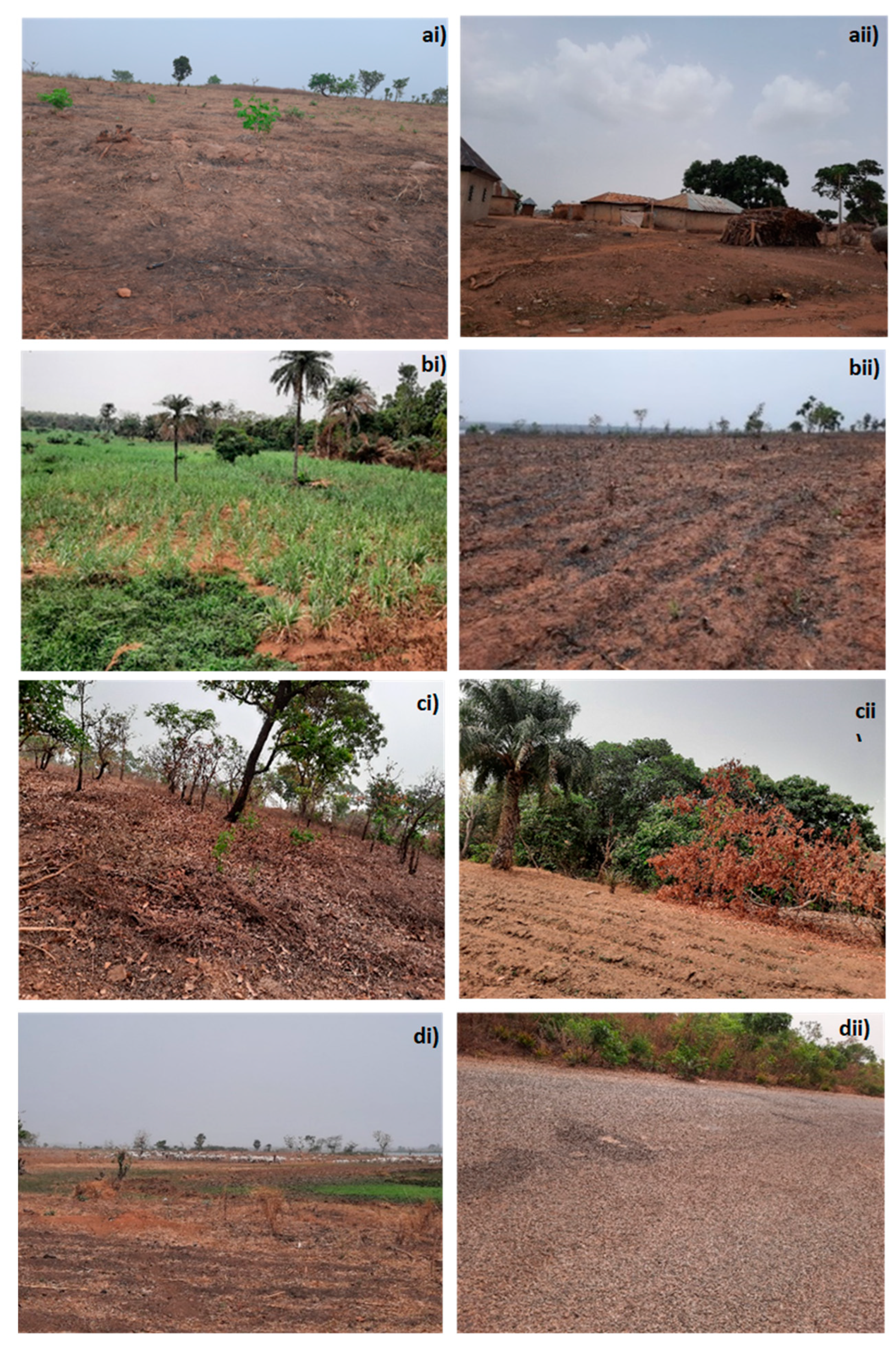
Plate 1. Evidence of identified land use activities around the gazetted forest reserves in the study sites. From top right: ai, ii) clearing primary forest land for agriculture activities and settlement in Odu Forest; bi, bii) Agriculture cultivation and fuelwood cultivation in Doma forest; ci, cii) clearing of forest area for farming activities and cultivation in Risha forest reserve; di, dii) show grazing activities in Doma and construction along Risha forest reserves. Sources: Fieldwork July, 2023.
This comparative analysis sheds light on the multifaceted nature of human activities and the drivers within the three gazetted forest reserves in Nasarawa State. The findings provide valuable insights into the varying degrees of engagement in agriculture, residential living, grazing, mining, hunting, fishing, and infrastructural development across the surveyed areas, contributing to a more comprehensive understanding of the human-environment dynamics in these forest reserves (Figure 3 and Figure 4).
3.4. Underlying (Indirect) Drivers of the Gazetted Forest Change in Nasarawa
Themes derived from quantitative data analysis, as mapped through NVivo project coding based on KII and FGD indicate interconnected factors such as population increase, poverty, climate change, corruption, governance, government policies, insecurity, land grabbing, and migration.
Figure 5.
Nvivo mapping codes from all stakeholders across the forest sites, showing perceived underlying drivers of forest change, as collected using KII and FGDs.
Figure 5.
Nvivo mapping codes from all stakeholders across the forest sites, showing perceived underlying drivers of forest change, as collected using KII and FGDs.
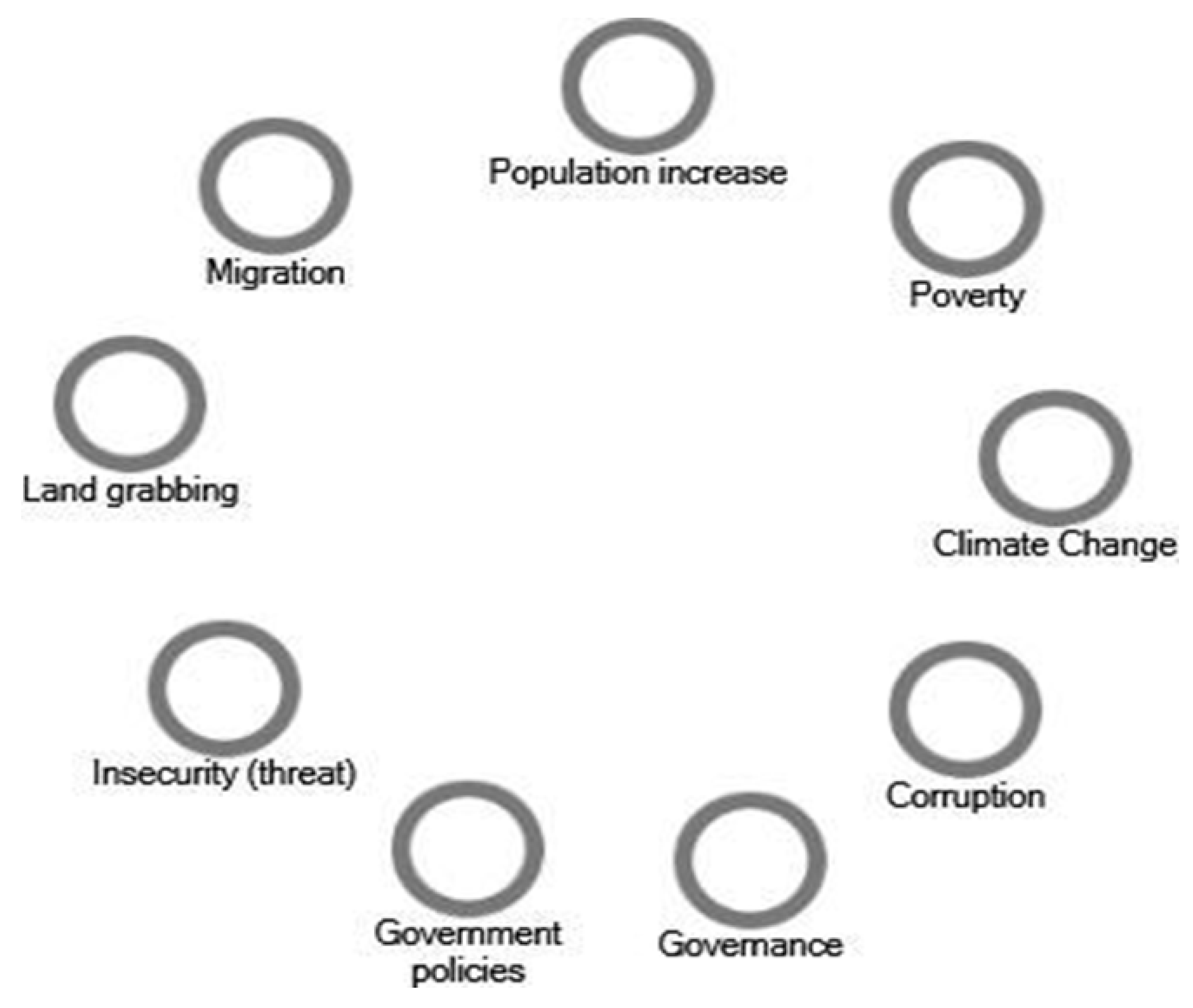
These codes represent the perceived underlying drivers of forest change identified during data collection. These drivers encapsulate the multifaceted and dynamic pressures contributing to forest degradation and alterations in surrounding communities. This analysis emphasizes the systemic nature of the challenges and provides a framework for understanding stakeholder perspectives on the underlying causes of forest changes.
3.5. Community Perceived Historical Drivers of Gazetted Forest Changes and Human Activities Around the Forest in Nasarawa State: Insights from Stakeholders (1966–2022) Across the Three Forests (Doma, Risha and Odu)
Understanding the variety of factors driving forest changes over time is critical for informed forest management and conservation strategies. This section examines stakeholders’ perceptions of the historical and contemporary drivers of forest change in Nasarawa State, Nigeria, between two distinct timeframes: 1966–2000 (the past) and 2001–2022 (the present) and the trajectories for the perceived drivers, and processes of change. This section also sheds light on the interplay of socio-economic, political, and environmental factors influencing forest cover, biodiversity and ecosystem change in the three gazetted forests. Appendix B: Table 1, Table 2, Table 3 and Table 4 show relevant quotes from the key stakeholders’ KII identifying perceived drivers while section 3.5.1–3.5.4. show the FGD summaries of stakeholders’ perceptions of the historical drivers of forest change trajectories and processes of change for gazetted forest reserve change.
3.5.1. Summary of Stakeholder FGD Comparative Content Analysis on the Trajectories, Perceived Drivers, and Processes of Change in the Doma Gazetted Forest Reserve Community
The local people and leaders FGD revealed that from the 1960s to 2000, Doma forest reserves were dense, biodiverse ecosystems with tall trees, vital wildlife, and minimal degradation. Between 2000 and 2022, deforestation intensified, resulting in significant biodiversity loss, wildlife extinction, and reduced forest cover. By 2022, the reserves had nearly disappeared, leaving degraded ecosystems and diminished community benefits. Both groups highlighted population growth as a major driver, leading to forest encroachment. Logging and timber extraction were significant factors, fueled by urbanization and state revenue policies. Agricultural expansion took a large permanent portion of the forest reserve mentioned by the two stakeholder groups. Community leaders pointed to charcoal production and commercial logging as key contributors, while community people mentioned government-issued orders for timber extraction. Leaders noted bushfires and overgrazing as major contributors, less emphasized by the local community. Both FGDs acknowledged extensive wildlife and biodiversity loss due to habitat destruction and hunting and emphasized neglect of management including inadequate enforcement of forest policies. On change processes, both groups agreed that population pressure and economic activities directly fueled forest clearing without reforestation. Leaders added that unsustainable grazing practices introduced invasive species and degraded the ecosystem further. Lack of enforcement, combined with local and state policy gaps, allowed extensive degradation to continue. Overall, the Doma forest reserve's decline is rooted in population pressure, agriculture expansion, economic exploitation, and policy failures, with nuanced variations between the two groups. Both acknowledged the urgent need for sustainable management to reverse the trend in the study area.
3.5.2. Summary of Stakeholder FGD Comparative Content Analysis on the Trajectories, Perceived Drivers, and Processes of Change in the Risha Gazetted Forest Reserve
From the 1960s to 2000, the Risha gazetted forest had dense vegetation, abundant wildlife, and flowing streams. Agricultural activities and human settlement were minimal, with government control preserving biodiversity. Species included lions, baboons, crocodiles, pythons, and tree species like mahogany and Terminalia spp. By 2001 to 2022, rapid forest degradation occurred due to agricultural expansion, deforestation, and near-total loss of forest cover. Biodiversity significantly declined, with many species disappearing or retreating. Open spaces replaced dense vegetation, streams dried up, and ecosystems were disrupted. Local community and leaders FGD identified key drivers: population growth and increased settlement driven by agricultural expansion into forest reserves. Deforestation for crop production converted forests into farmland. Economic pressures led to timber extraction, charcoal production, and firewood harvesting. Bush burning contributed to hunting, land clearing, and farming, causing forest destruction. Overgrazing by Fulani herders caused soil compaction, tree damage, and loss of tree cover and grassland as revealed in the two FGDs. However, it is noteworthy that Fulani herders were not included as participants in these FGDs due to their inaccessibility, which precluded the opportunity to gain insights into their perspectives regarding the impact of their activities on forest degradation.
The local community FGD revealed deforestation from logging, agricultural expansion, and firewood/charcoal extraction led to habitat destruction and biodiversity loss. This displaced wildlife, with animals fleeing and species like crocodiles, pythons, and buffalo disappearing. Cultural and economic shifts transformed forests from traditional conservation areas to sources of short-term economic gains. The transformation of the Risha forest reserve is attributed to direct and indirect interconnections such as social, economic and environmental factors that have altered the forest reserve cover, ecosystem, and biodiversity.
3.5.3. Summary of Stakeholder FGD Comparative Content Analysis on the Trajectories, Perceived Drivers, and Processes of Change in the Odu Gazetted Forest Reserve
For Odu between 1960–2000, the local community FGD revealed that forests remained largely intact due to low population density, strict traditional laws, and minimal economic reliance on forests. Wildlife and valuable tree species thrived under traditional regulation. However, community leaders noted that forest size began to reduce gradually from logging for local and commercial use, additionally driven by agricultural expansion and bushfires, while fauna and flora species started depleting due to weak enforcement. 2001-2022, the local community explained that forest degradation accelerated due to economic pressures. Deforestation was driven by timber operations, agricultural expansion, charcoal production, and bush burning, leading to habitat loss, reduced wildlife, and insecurity. Community leaders attributed the change to rapid forest degradation from population growth, poverty, and weak forest management. Overexploitation for fuel, farming, and urbanisation led to forest cover and biodiversity loss, soil erosion, and a decline in forest resilience. The community revealed that processes of change between the 1960s and 2000 were characterised by traditional forest protection systems giving way to unsustainable practices, leading to significant forest cover change and biodiversity loss. Community leaders pointed out weak governance and lack of reforestation led to unsustainable exploitation, while rapid urbanisation and reliance on forest resources due to poverty further accelerated degradation. The local community focused on unregulated timber extraction (sawmills) and shifting cultivation as key drivers, while community leaders highlighted urbanisation and population growth, poverty, and lack of effective forest governance as critical causes, also noting climate change's influence on forest change.
3.5.4. FGD Content Analysis for Government Officials and Expert Stakeholder Groups on the Trajectories, Drivers, and Processes of Change in Gazetted Forest Reserves in the Study Area
During the period from the 1960s to 2000, both Government and Expert Focus Group Discussions (FGDs) noted gradual deforestation, driven by population growth, agricultural expansion, and timber extraction. Infrastructure development contributed to forest degradation, albeit slower compared to subsequent years. Experts highlighted bushfires as a significant contributor. Biodiversity loss commenced, with declining flora (e.g., Parkia) and fauna (e.g., primates, elephants). From 2001 to 2022, both groups emphasised accelerated deforestation driven by rapid population growth, agricultural expansion, urbanisation, and economic pressures. Charcoal production, commercial timber harvesting, and mining were identified as major drivers. Experts highlighted rising energy costs leading to increased firewood and charcoal use. Both groups noted the impact of climate change, policy inconsistencies, and inadequate reforestation efforts. Faunal extinction became more pronounced, with large mammals and valuable tree species experiencing drastic declines. In summary, government officials and experts revealed that processes of change between the 1960s and 2000 were characterised by gradual degradation due to farming, timber harvesting, and infrastructure development, while 2001-2022 processes exhibited accelerated deforestation caused by expanded agricultural activities, unsustainable resource exploitation, and urbanisation. Both groups identified the interplay of population growth, economic need, and policy failures as primary drivers of forest degradation. Experts provided additional ecological insights and highlighted specific socio-economic factors as contributors to the change. Table 3, Table 4 and Table 5 present the overview comparison, similarities and differences in stakeholder FGD insights and perspectives.

Table 3.
Overview of stakeholder perspectives for the FGD content analysis of findings on forest reserve changes and drivers.
Table 3.
Overview of stakeholder perspectives for the FGD content analysis of findings on forest reserve changes and drivers.
| Forest Reserve | 1960-2000 | 2001-2022 | Key Drivers of Change | Processes of Change |
|---|---|---|---|---|
| Doma | Dense, biodiverse forests with tall trees and abundant wildlife. Minimal degradation. | Significant deforestation, biodiversity loss, and near disappearance of reserves. | Population growth, agricultural expansion, logging, charcoal production, bushfires, overgrazing, weak policy enforcement. | Loss of vegetation cover, economic exploitation, lack of reforestation, Habitat destruction, invasive species, and inadequate enforcement. |
| Risha | Rich vegetation, wildlife, and water bodies with strong government control. | Near-total forest cover loss, ecosystem disruption, species extinction, water body depletion. | Agricultural expansion, timber/charcoal extraction, firewood harvesting, and overgrazing. | land clearing, Hunting, changing cultural attitudes towards conservation, and economic pressures. |
| Odu | Intact forests with strong traditional laws limiting exploitation. | Accelerated degradation, habitat loss, soil erosion, reduced resilience. | Logging, agricultural expansion, urbanization, timber extraction, overgrazing, weak governance, climate change. | Shift from traditional conservation to unsustainable exploitation, changing cultural attitudes towards conservation, population pressure, and economic reliance on forest resources |
Table 4.
Comparative analysis of the trajectories, drivers, and processes for the government and expert FGDs.
Table 4.
Comparative analysis of the trajectories, drivers, and processes for the government and expert FGDs.
| Time Period | Government and Expert Observations | Key Drivers | Processes of Change |
|---|---|---|---|
| 1960-2000 | Gradual deforestation due to farming, timber harvesting, and infrastructure development. Biodiversity loss began. | Population growth, agricultural expansion, timber extraction, charcoal/ fuelwood extraction, infrastructure projects, bushfires. | Slow but steady degradation, early signs of habitat and species decline. |
| 2001-2022 | Accelerated deforestation, faunal extinction, and significant ecological decline. | Rapid population growth, agriculture expansion, urbanization, economic pressures, increased reliance on firewood/charcoal, mining, weak governance, and reforestation efforts. | Unsustainable resource exploitation, policy failures, climate change impacts. |
Table 5.
Similarities and differences among stakeholders' FGDs on the perceived drivers, impacts and process of change of the gazetted reserves.
Table 5.
Similarities and differences among stakeholders' FGDs on the perceived drivers, impacts and process of change of the gazetted reserves.
| Aspect | Similarities | Differences |
|---|---|---|
| Time Period | Government and Expert Observations | Key Drivers |
| Perceived Drivers | All stakeholders identify population growth and urbanization, agriculture, logging, and weak governance as primary drivers. | Local communities emphasize immediate livelihood needs, while the government and experts highlight policy failures and economic exploitation. |
| Impact on Biodiversity | All agree on significant biodiversity loss and ecosystem disruption. | Experts provide detailed ecological insights, while local stakeholders focus on visible wildlife disappearances. |
| Processes of Change | Generally, the consensus socio-economic (livelihood) activities accelerate deforestation. | Government officials acknowledge policy gaps, whereas communities highlight economic survival needs. |
| Solutions & Management | Recognition of the need for sustainable management, reforestation, and policy enforcement. | Experts advocate scientific conservation approaches, while local leaders stress traditional conservation methods. |
The comparative stakeholder analysis highlights the stakeholder perspectives on forest reserve changes, and the narratives from FGDs across stakeholder groups underscore diverse perspectives on forest reserve trajectories, drivers of change, and processes shaping forest ecosystems across the three gazetted forest communities. Each group's viewpoint is rooted in their interaction with and reliance on the forests, as well as their capacity for control over forest resources.
Local communities and leaders depicted dense, biodiverse forests in the 1960s, gradually transforming into degraded landscapes due to population growth, economic pressures, and weak enforcement. Their perspectives blend personal experience and direct reliance on forest resources, emphasizing agricultural expansion, charcoal production, and timber extraction as primary drivers of deforestation. Community leaders also highlighted policy failures and urbanization as accelerants of forest loss, with nuanced variations in emphasis on issues like overgrazing and bushfires.
Government officials and experts provided a broader policy-oriented and ecological perspective. They aligned with local accounts of deforestation drivers but enriched the analysis with insights into the interplay between climate change, energy demand, and governance challenges. Experts, in addition, highlighted the ecological consequences of forest degradation, including biodiversity loss and species extinction, offering a systems-level understanding of socio-economic and environmental transformations.
Consistent themes emerged across all FGDs: population pressure, economic exploitation of forest resources, and governance failures were identified as central drivers of deforestation and biodiversity loss. However, the analysis revealed the need for disaggregating perspectives. Local communities emphasized immediate livelihood challenges, while experts provided more long-term and systemic analyses of forest degradation. This divergence underscores the importance of considering each group's unique vantage point to design inclusive and sustainable forest management strategies. The findings emphasize the urgency of integrating local knowledge, expert insights, and governance reforms to reverse forest decline. Effective management must address underlying drivers such as poverty, urbanization, and policy gaps while promoting reforestation, agroforestry and sustainable resource use. An integrated approach that combines policy reform, community engagement, and scientific conservation is essential for the sustainable management of the Doma, Risha, and Odu forest reserves and beyond.
3.6. Population Growth and Climate Change Variable (Temperature and Precipitation) of Nasarawa State
To evaluate the population growth and climate variable of the study area as consistently revealed across stakeholder perceptions, Figure 6, Figure 7 and Figure 8 indicate that over the years covered in this study (1986-2020), Nasarawa State has experienced significant climate variability with an overall trend of increasing temperatures and fluctuating rainfall. Simultaneously, the population has seen substantial growth, more than tripling from 1986 to 2020. These changes may have implications for the region's forest cover, agriculture activities, ecosystem services and overall sustainability of the gazetted forest reserve, and indeed, were noted by stakeholders.
3.7. Community Evaluation of Key Drivers and Human Activities Behind Changes in the Gazetted Forest Reserves Across the Three Study Areas
This section examines and evaluates the perceived primary factors (key drivers and human activities) identified and recognised by local communities and stakeholder participants across the three (Doma, Risha and Odu) forest reserves (Figure 3 and Figure 4). Data from KIIs are in Appendix A Table 1–5; FGD Section 3.6.1–3.6.3 and Table 3, Table 4 and Table 5.
3.7.1. Doma Forest Reserve
a) Agricultural Expansion
In Doma forest reserve’s household survey, agricultural expansion was perceived by most of the respondents as the largest driver of forest cover changes. Qualitative insight from content analysis of Doma stakeholder KIIs (Appendix B Table 1 and section 3.5.1) revealed that farming activities, initiated in the 1970s, have led to widespread deforestation, with trees felled to create farmland for crops like yam, maize, guinea corn and beans (Appendix B Table 1 and section 3.5.1). FGDs and KIIs confirmed this trend, with participants noting that the increasing demand for farmland and settlements has driven deforestation in Doma (Table 3, 4). Moreover, field observations in 2022 by the researcher further revealed ongoing agricultural activities in and around the reserve, contributing to deforestation (plate 1).
Overall, household survey data support the qualitative findings, indicating that agricultural expansion is the principal driver of forest loss in Doma as perceived by the community. The community describes a situation where people on the agricultural frontier actively clear land to make room for farming.
Stakeholders also observed that land is initially cleared because of valuable resources, particularly timber. Agriculture then gradually follows, degrading the forest over time. Eventually, agricultural activities rapidly occupied the cleared space permanently.
Stakeholders also noted that land is first cleared because it contains a valuable resource (timber) and the agriculture moves in behind on the processes gradually degrade the forest and agriculture moves in rapidly to occupied permanent space on the reserve between 2001 and 2020, indicating that agricultural activities influence the substantial change to the reserve area.
b) Lumbering
Lumbering is another key driver and human activity of the gazetted forest change in Doma, as shown in the household survey (Figure 3, Appendix B Table 1 and section 3.5.1). The KII and FGD revealed that the primary activity of lumbering is timber extraction, which is carried out through non-commercial and commercial logging by the community people and the government. The extraction of selected important tree species for both commercial and non-commercial timber purposes has targeted species such as Iroko, Obeche, and mahoganies found in the forest reserves. This could impact forest quality, composition, and size, leading to a decrease in forest cover.
Clear-cutting practices contribute directly to forest degradation, with agricultural expansion taking over areas previously degraded by timber extraction. Qualitative data (Appendix B Table 1-4) and sections 3.5.1-3.5.4. reveal this trend.
KIIs and FGDs noted that increasing population pressures have led to higher demand for timber for construction purposes, further exacerbating deforestation within the reserve. Participants reported that clear-cutting practices and selective logging of valuable tree species have significantly altered the forest composition in Doma. For example, within the KII, a participant explained that; “The practice of timber extraction has persisted for decades of years, focusing on economically valuable tree species like Iroko, mahogany, obeche, shear butter trees. These trees have been harvested to meet the substantial demand for timber exports, serving diverse applications abroad and within local communities. This industry includes forest-dwelling individuals and private commercial enterprises, generating revenue for governmental bodies. Consequently, these logging operations have significantly altered the designated forest reserve” (Doma Local People KII 003, June 2022).
c) Fuelwood/Charcoal Production
Fuelwood/charcoal production was identified and perceived as one of the primary drivers and anthropogenic activities contributing to forest change and degradation in Doma, according to 94% of survey respondents. These activities are essential for household energy and income generation. In the qualitative results from FGD, the local people confirmed that specific tree species are harvested for fuelwood and to produce charcoal, resulting in a reduction of forest cover over time (Appendix B Table 1 and section 3.5.1). One of the leader participants from Doma KII further elaborated: "Local communities frequently harvest trees, such as Vitellaria paradoxa (shea tree), Daniellia oliveri (African Copaiba balsam tree), and Prosopis africana, for firewood and high-quality charcoal due to their dense wood and high calorific value. This targeted harvesting has significantly contributed to the depletion of forest cover and resources in the reserve, driven by domestic use and economic necessities" (Doma, local community leader KII 004, June 2022). Observations during fieldwork confirmed the ongoing exploitation of the forest for fuelwood, which aligns with household survey, KII and FGD findings (Plate 1).
d) Grazing
Grazing by livestock, particularly cattle and cows was perceived to be a driver that contributed to forest degradation in Doma as identified by 81% of respondents (Figure 3, 4). FGDs revealed that herdsmen allow livestock to graze on croplands and grasslands and cut some specific tree species to feed their livestock within the reserve, which reduces forest cover and grassland composition. Cattle trampling and cutting of branches for fodder further exacerbate the problem. Additionally, herders have been reported to clear forested areas to build camps, adding to deforestation pressures noted by both the local people and leader stakeholders (Appendix B Table 1 and section 3.5.1). The KII participants from the local community in Doma elaborated and further confirmed that "Grazing by herdsmen contributes to the destruction of the forest reserve; they move into the forestry area and cut down the trees and grasses to feed their animals', this reduces the composition and size of the forest reserves; their activities affect forest growth and cover" (Doma, Community people KII 003, June 2022), Appendix B Table 1.
3.7.2. Risha Forest Reserve
The results of the household survey in Risha considering perceptions of the drivers and human activities that contribute to the gazetted forest reserve change in their community are presented in Figure 3,4.
a) Agricultural Expansion
In Risha forest reserve, agricultural expansion was perceived by most of the respondents as one of the substantial drivers that influence the forest cover change in the area. This was cropland expansion observed to expand and cover permanent areas of the reserve (fieldwork, 2022). Qualitative insight from the stakeholders (Appendix B Table 2 and section 3.5.2) revealed that by 2001 to 2022, rapid forest degradation had occurred due to agricultural expansion and near-total loss of forest cover in this forest reserve, as observed during the fieldwork.
Local community and community leaders participating in KIIs and FGDs reported that agricultural expansion began several decades ago and remains a critical driver of deforestation and the forest cover change in Risha. Agricultural expansion is a primary driver of major changes in forest areas, directly leading to the permanent conversion of forests into agricultural land. This process involves communities clearing forests to create new cropland and expand settlements, with cropland almost entirely replacing the reserve's original forest cover before other factors contributed to further changes. For example, one of the participants further reiterated that “The forest reserve has changed due to agriculture expansion because we are farming there. We farm crops like yam, groundnut, melon, maize, guinea corn, beans, and soya beans and so on” (Risha Local leaders KII 001, June 2022) (Appendix B Table 2 and section 3.5.2). The local community stakeholders' insights from the FGD further elaborated on how cropland expansion on the forest reserve was observed from the initial stage and the characteristics behind the change (Section 3.5.2).
b) Lumbering
The household survey identified lumbering as a major contributor to forest decline in Risha (Figure 3). The qualitative data from the content analysis revealed that a large number of trees were degraded for timber extraction for construction and other uses, leading to significant forest loss in Risha. Selective logging of valuable species like Gmelina, Obeche, Mahogany and Iroko has reduced forest quality and composition. These species are selectively logged due to their economic and commercial value, though they cause excessive exploitation that leads to deforestation and loss of biodiversity in the reserve. FGD participants (Table 3 and section 3.5.2) further noted that as the population grows, the demand for timber increases, driving unsustainable logging practices in the reserve, one of the key contributors to forest decline in Risha. One of the local stakeholders reiterated that: "Lumbering is one of the key contributors to human activities that lead to the degradation of the forest reserve in this area. People are often felling or cut down trees in and around protected forest areas, particularly to obtain timber for construction materials such as roofing houses. Over time, this persistent practice not only depletes tree populations but also undermines efforts to maintain the ecological balance and biodiversity within this reserve” (Risha, Local people KII 004, June 2022) (Appendix B Table 2 and section 3.5.2)
c) Fuelwood/Charcoal Production
Fuelwood/charcoal production was perceived as one of the critical drivers and human activities for livelihoods in Risha, with 90% of household survey respondents acknowledging their role in forest cover change and degradation. The qualitative results from FGD elaborated that the communities cut down trees from the reserves which are the sources of their energy use at home and also they sell them for their economic gain as a source of income for their families. Community leaders confirmed that tree cutting for fuelwood/charcoal production is a common practice, reducing the forest’s ecological integrity (Table 3 and section 3.5.2). A KII participant reiterated this perspective, stating; “Most of our people “indigenes” cut down trees to produce charcoal and firewood; also, the trees provide us with construction materials which we construct our houses and also sell to generate income for ourselves and our families, and I think it could be a crucial driver for the gazetted forest reserve changes” (Risha Community Leader KII 004, June 2022) (Appendix B Table 2 and section 3.5.2). Observations during fieldwork in 2022 revealed active woodlot and charcoal production sites around the reserve (Plate 1).
d) Grazing
Grazing activities in Risha were perceived to have notably impacted the forest reserve as identified by a large proportion (90%) of the respondents (Figure 3, 4). Qualitative insight from the FGDs for both the local people and the community leaders highlighted that cattle graze on remaining cropland stalks and grasslands within the reserve, which diminishes forest cover, trees and grassland cover. Livestock overgrazing causes new trees not to regenerate and compacts the soil, while tree cutting for fodder further reduces forest composition. Both the stakeholder groups emphasized the challenges posed by herdsmen clearing trees for grazing purposes and building camps within the reserve, which trigger the fast loss of forest cover within the reserve areas. For example, one of the stakeholders from the community in Risha KII further added that: “Fulani herdsmen's livestock grazing practices, including overgrazing causes overgrazing on grasslands and damages regenerated trees, trampling on soil by compaction and destruction of tree roots by trampling and cutting down trees for fodder and camp construction, significantly contribute to forest degradation within this forest reserve” (Risha, Local people KII 002, June 2022) (Appendix B Table 2 and section 3.5.2)
3.7.3. Odu Forest Reserve
The results of the household survey for Odu gazetted forest community perceptions for the drivers and human activities that contribute to the gazetted forest reserve change are shown in Figure 3 and Figure 4 and the qualitative results are presented in (Appendix B Table and section 3.5.3). The respondents perceived agricultural expansion, lumbering, and fuelwood/charcoal production as higher among the other drivers (100%, 90% and 80%) respectively, however they also perceived natural disasters/ climate change, grazing, settlement, and construction to contribute to the change (Figure 3, 4).
a) Agricultural Expansion
Agricultural expansion was perceived as the prevalent driver influencing forest change in the Odu forest reserve by most respondents from the surrounding forest communities (Figure 3 and Figure 4). According to qualitative information from FGD (Table 3 and Section 3.5.3) farmers were practising shifting agriculture as a traditional way of agriculture by increasing farmland on existing established farms left over the years that followed, cultivating crops such as yam, maize, beans, and cassava, contributing to forest clearing and change in the reserve. Furthermore, the FGDs for both the local community and local leaders revealed that agricultural land expansion, with shifting cultivation (agriculture) driven by population growth and livelihood needs, influences changes in the reserves, including biodiversity loss (Table 3, section 3.5.3). More also, in a KII, one of the participants further that: "Agriculture has contributed to forest changes here since 1970s, as we depend on farming and forest resources for income and survival, with no alternative livelihoods" (Odu, Local Community People, KII 003, June 2022) (Appendix B Table 3)
b) Lumbering
Timber extraction and logging has also contributed to deforestation and forest cover loss in Odu as a driver (Figure 3 and Figure 4). The qualitative data revealed the trend, with participants reporting extensive logging of species like Obeche, opepe, African Copaiba, Iroko and Mahogany for construction and furniture making (Appendix B Table 3 and Section 3.5.3). KIIs and FGDs highlighted that increased demand for timber in the growing population has intensified forest exploitation. This has reduced the availability of valuable tree species and altered the reserve’s ecological balance. Community leaders in FGDs (Table 3 and Section 3.5.3) noted that the forest size began to reduce gradually from logging for local and commercial use, additionally driven by agricultural expansion and other drivers. In a KII, another participant from the local community added that “Trees like mahogany, iroko and so on, I don’t know their names, were selected and massively cut out for timbers for houses, roofing and other constructions, affecting tree cover in the forest and even wild animals and other valuable trees, now hardly you seem them in the forest” (Odu, Community People, KII 002, June 2022).
c) Fuelwood/Charcoal Production
Fuelwood/charcoal production contributed a considerable role in the gazetted forest degradation and change perceived by a substantial numbers of household survey respondents in Odu (Table 3, 4). Community leaders in FGD confirmed that many residents rely on these activities for energy and income generation. Specific tree species are targeted for charcoal production, which has further reduced the forest’s size and composition (Table 3 Section 3.5.3). In a KII, one of the participants further elaborated that: “Some of our people cut down trees for firewood and charcoal, targeting specific trees, which has depleted forest covers and resources from this reserve. For instance, tree species such as Vitellaria paradoxa (commonly known as shea tree), Daniellia oliveri (African Copaiba balsam tree), and Prosopis africana are frequently harvested for high-quality charcoal due to their dense wood and high calorific value. The widespread cutting and burning of these trees for charcoal for domestic use and economic gain” (Odu, Local Community People K II 005, June 2022) Appendix B Table 3.
d) Grazing
Grazing was perceived as one of the key drivers and human activities that affected change in forest cover in the Odu forest by over 69% of household survey respondents (Table 3), although the impact appears less severe compared to Doma and Risha from the community stakeholders' narrative. FGDs reported that Fulani herdsmen rearing livestock such as cattle and cows overgraze the land, trampling of soil and young regenerating trees, and the cutting of trees for fodder contribute to forest degradation. Focus Group Discussions (FGDs) reported that Fulani herdsmen, while rearing livestock such as cattle, contribute to forest degradation through overgrazing, trampling of soil and young regenerating trees, and the cutting of trees for fodder. One of the participants from the KII (Appendix B Table 3) further revealed that “Animals have been grazing around the reserve by Fulani [Herdsmen] over the parcel of land within the forest reserve area. The cattle and cows’ footsteps are overstepping the forest by feeding on the grass within the reserve area and cutting down branches of trees for their animals to feed on, and at times they even cut down the trunks for grazing purposes. Again, they cut down the trees to build their camps (houses), and now they are even going to the roots to uproot the trees (Odu, Local people KII 001, June 2022) (Appendix B Table 3 and section 3.5.3)
3.8. Evaluation of Underlying (Indirect) Drivers of the Gazetted Forest Change in Nasarawa State
In addition to direct drivers that lead to the forest change, the KII and FGD revealed underlying (indirect) drivers of land use and gazetted forest reserves change in the study area, identifying population growth, poverty, government policies, poor governance, and corruption which are similar across the three forest reserves (Figure 5, Appendix B Table 1–4 and section 3.5.1–4). Other indirect drivers are climate change and disasters (unreliable rainfall and temperature). The results are shown in Figure 5, from the NVivo mapping across the themes and Figure 7 and Figure 8. The details of some of the key indirect drivers are discussed as follows.
a) Population growth
The majority of the KII and FGD participants from the local people, leaders, government officials and experts perceived the population of the area had increased over the studied period, thereby influencing human activities, particularly agricultural land expansion on the reserves, with the interaction of other drivers such as settlement which led to high demand for timber and other forest resources in the area. The population trend of the state had shown a significant increase for the period covered by this study (Figure 6). The increasing population pressure leads to increased demand for farmland, placing increasing demands on forest resources and increasing activities that lead to forest change. FGDs and KIIs confirmed that population increase in the area influences the direct drivers that led to a significant change in the forest reserves (Appendix B Table 1–4 and section 3.5.1–3.5.4). For example, a stakeholder participant stated that “Population growth has significantly impacted forest cover and ecosystem change, interacting with other environmental pressures and direct drivers. For example, the demand for livelihood sources is influenced by population growth. Prior to 1960, the population that led to extraction and degradation remained low. However, since 2000, deforestation has escalated, largely driven by rapid population growth within the state and local communities” (Doma Local people, KII 002, July 2022). Another participant further explained in Risha that “Due to population increase around this area, people started claiming ownership and open agricultural land for farming purposes around 1998 to date that led to significant forest cover change of the forest reserves area” (Risha forest, Local person 003, (Female) KII July 2022). One of the expert stakeholder participants added that “Due to the consistent ever-increasing human population in this area, it results in increasing demand from people for other land use and human activities for livelihood, which is the key driving force of the forest change" (Expert KII 004, June 2022) (Appendix B Table 1–4 and section 3.5.1–3.5.4)
To confirm the community’s perception of population growth, the study area population data from 1986 to 2020 was analysed (Figure 6). The population experienced a substantial growth of 75% between the years 1986 and 2020, rising from 939,471 to 2,895,432 individuals, with this rapid growth driven by birth rate trends and migration. During this period, the average annual increase was 2.5 % (https://www.nationalpopulation.gov.ng). The consistent rise in the population depicted in Figure 6 over time demonstrates this growth trend, remaining apparent despite the unavailability of precise statistical population data for the gazetted forest community.
b) Poverty
Poverty was one of the underlying drivers mentioned in the study area that influenced the land use and forest change in both the KII and FGDs across the three forest reserve areas. This was corroborated with demographic characteristics from the household survey (Appendix A, Figure 1, Table 1–4). Many of the gazetted forest communities are farmers and villagers living in low socioeconomic conditions, which made them dependent on forest resource as a means of attaining a livelihood, which in turn, exerts pressure on the resource and leads to changes in the forest reserves. The KII and FGD participants explained this underlying driver in detail (Appendix B: Table 1–4 and section 3.5.1–5.4). For example, in Risha forest reserve, one of the participants stated that “Poverty is one of the major drivers that led to changes in the forest reserves: we expand our agricultural land in the forest to get our livelihood since we have no good way of getting food or money to survive” (KII Risha Local person 005, June 2022). Moreover, a community leader in Doma emphasised that “Poverty is a significant driver of changes in the forest reserve. People exploit this forest to sustain their livelihoods and meet economic needs, with community members often clearing parts of the forest to access and utilize its resources” (KII Doma Local person 005, June 2022) (Appendix B Table 1–4 and section 3.5.1–5.4). One of the participants further explained the government's understanding: " One of the main reasons for changes to the forest reserve is poverty and this is a fact. The fact is that community members need money for their livelihoods and economic survival, which leads them to clear the forest around them for resources access and use” (KII Government official 005, June 2022) (Appendix B Table 4 and section 3.5.1–5.4). In addition, the household survey ( Section 3.1, Appendix A, Figure 1) showed that the individual households in the study communities rely predominantly on non-salaried sources of income, with a substantial proportion earning insufficient income. The study's findings indicated that many of the respondents were farmers who did not have reliable sources of income to supplement their monthly earnings and sustain their livelihoods. This is consistent with the participants' statements, who highlighted that poverty in the study area is a contributing factor to the overexploitation of forest resources in the absence of alternative means of subsistence. This conclusion is supported by the KII and FGD content analysis presented in (Appendix B Table 1–4 and sections 3.5.1–5.4). Poverty has also increased the rate of deforestation and forest degradation in the study area due to increased demand for fuelwood and other domestic uses in the study area as reported by the local community findings in this study. This is because these communities are heavily dependent on natural resources to meet their daily needs. The forest is therefore frequently subject to unsustainable exploitation due to the heightened demand for woodfuel for use and generating income and other forest resources that are essential for their immediate survival and economic stability.
c) Poor Governance/policies and corruption
Poor governance was among the hurdles limiting the success of conserving forests and their associated biological diversity in the study area and contributed to the decline in forest reserves as identified by many participants from the KII and FGD across the three forest communities (Appendix B Table 1–4 and section 3.5.1–5.4). Poor governance includes issues such as corruption and embezzlement of funds, which have adversely affected the performance of the forest conservation sector. This is exemplified by the detrimental consequences of management and monetary issues, as well as the accelerating violation of natural resource conservation laws among others, which greatly influence the changes in the forest reserves of the area. This was particularly the case in Doma where community leaders reiterated this problem. For example, one of the stakeholders revealed that “Before now, government do take good care of the reserves but now less attention is given, so people go into the reserves and cut down trees in the reserve any time without any taken proper permission” (Doma local people KII 005, June 2022) (Appendix B Table 1).
Poor governance for instance can affect the policy implementation that contributed to the change of the gazetted forest in the study area. Government policies governed the establishment of the PAs and forest reserves which were intended to help reduce the overall forest loss and degradation, limiting the areas in which concessions could be granted. However, many of the PAs and reserves were poorly managed and limited in resources and capacity due to the policy's failure in terms of implementation. This affects other drivers that interplay and that contribute significantly to the gazetted forest reserves in the study area, as explained by the participants in the KII and FGD (Appendix B: Table 1–4 and section 3.5.1–5.4) across the stakeholder groups. For example, a government participant stated: “Government policies are often contributing to deforestation in forest reserves. This is because these policies are not always implemented in a manner that aligns with the needs of the people for conservation. For instance, Nigeria's high cost of natural gas, cooking gas, and kerosene has led to a situation where poor residents in forest communities are forced to resort to forests for their energy needs. This has resulted in the degradation of the ecosystem and a change in the forest cover” (Government official KII 002, June 2022). (Appendix B Table 1–4 and section 3.5.1–5.4) gives other details of some of the KII and FGD insights on policy as a driver for the forest change.
Poor governance and policies were also perceived to influence corruption by some of the forest officials in the study area. For instance, when it comes to obtaining permits or documents, bribes were reportedly necessary. This includes using bribes to secure access to forest reserves for farming, timber, and other uses, as well as to obtain agricultural concessions in these reserves. In some cases, domestic companies may even pay bribes to subcontract and overharvest logging concessions, and members of local communities and government officials are involved affecting the governance for the protection of the forest particularly noted in the Risha forest community (Appendix B Table 4). A participant in one of the forest communities, the Risha revealed that: “The government forest officers assigned to monitor, manage, and enforce the forest laws against encroachments in this forest reserve encourage the community and even foreigners by collecting small bribes from them and then allowing them to enter the forest and degrade it for timber extraction, agricultural, and other uses, which leads to a high rate of cutting forest trees and a change in the forest reserves” (Risha local people KII 004, June 2022) (Appendix B Table 2).
Furthermore, the stakeholders for both the KII and FGD expert and government official groups perceived similarly driver emphasised accelerated deforestation to change around this gazetted forest driven by rapid population growth, urbanisation, and economic pressures such as agricultural expansion, lumbering and fuelwood/fuel across around the forest reserve. Additional underlying (indirect) factors contributing to changes in the forest reserve in the area, as identified in the KII, include migration and insecurity (terrorism threats). However, they do not seem to have as much impact as other drivers on the gazetted forest change according to the stakeholders’ perceptions.
3.9. Correlation of the Key Insights for the Household Survey KIIs and FGD for the Study
In Doma Forest, a significant number of local community members and leaders identified agricultural expansion, lumbering, fuelwood collection/charcoal production, and grazing as the primary direct drivers of forest change. Similarly, in Risha, local households, community members, and leaders perceived these same direct drivers as being closely linked to livelihood needs (Appendix B Table 1–4). In contrast, in Odu, while similar direct drivers were identified, lumbering was perceived as the first most influential driver, followed by agriculture, fuelwood/charcoal collection, and grazing.
Across all three forests, a substantial number of participants and stakeholders recognized human population growth, poor forest governance, and poverty as the key underlying drivers of forest degradation. These factors emerged as dominant concerns among local community members including the government and experts KIIs, and FGDs.
Notably, while most respondents from Doma, Risha, and Odu were farmers, they primarily linked forest change to economic necessity. On the other hand, stakeholders with higher education, including government officials and experts, shared a similar perception of the drivers but also emphasised policy failures and weak enforcement as critical factors influencing forest degradation.
In summary, the analysis reveals that while all three forest reserves in Nasarawa State face similar drivers of forest change, the qualitative data shows that their perceived intensity, trajectories and scale vary. Risha and Doma were perceived to exhibit the highest levels of agricultural expansion and forest degradation in the reserve, as evidenced by all data sources, while Odu's forest community perceived cultural controls of the traditional land use pattern of shifting cultivation. In Risha and Doma reserves, individuals on the agricultural frontier actively cleared land for permanent agriculture, as perceived by the community. In Odu reserve, the community revealed that land was initially cleared for valuable timber, with agriculture subsequently encroaching, later, while various drivers and processes (e.g., population growth, poverty, and grazing) gradually contributed to the change in the degraded forest, leading to rapid agricultural expansion in some decades. However, Odu is currently experiencing a gradual to rapid recovery as observed from the fieldwork by the researcher, also reported by the stakeholder, attributed to a shift in traditional agriculture.
Stakeholders from expert and government officials KII and FGD perceived similar drivers and human activities, noting agricultural expansion driven by population growth and timber extraction as gradual or fast causes of deforestation and forest cover change around the reserves. Underlying drivers such as population growth, poverty, poor governance, and corruption are perceived to be common across all reserves. Population growth has increased pressure on forest resources, while poverty has driven communities to exploit forests for livelihoods. Poor governance and weak policy implementation have exacerbated deforestation in all reserves. However, these underlying drivers are perceived more widely in Risha and Doma, where forest degradation is more extensive compared to Odu from the revealed perception of these areas (Table 1–4 and section 3.5.1–5.4). Addressing these drivers requires targeted interventions for conservation and management, including improving governance, providing alternative livelihoods, and promoting sustainable land use practices.
4. Discussion and Implications
4.1. Interplay Between Social and Biophysical Drivers of Forest Change
The intricate relationship between social and biophysical processes that drive land-use changes, particularly those impacting forest cover, is influenced by a combination of direct and underlying factors, often stemming from human activities [8,65]. This dynamic was evident in the current research, where most participants from gazetted forest communities attributed forest change primarily to this interplay between socio-economic factors and biophysical processes. Most of the historical drivers and human activities that drive the gazetted forest change were similar across the three gazetted forests (Figure 3 and Figure 4). However, perceptions differed of construction and settlement drivers in terms of their contributions to change in the forest across the three sites surveyed. Each group's viewpoint is rooted in their interaction with and dependence on the forests, as well as their capacity for control over forest resources.
4.2. The Impact of Forest Loss on Livelihoods and Socioeconomic Dynamics
Understanding socioeconomic drivers and forest change reveals how incentives and constraints shape human interactions with forest ecosystems. The research highlights those socioeconomic drivers of forest change in the studied areas, with findings consistent with those of previous studies, such as Sahuri et al. [67], which reported on changes in the Bukit Suligi Protected Forest Area. Communities around the forest reserves in the study area experience economic challenges (poverty), which may impact the exploitation of forest resources across the three forest reserves, with 81% of respondents being farmers, this creates pressure on gazetted forests through extensive clearing. Activities like agricultural expansion, fuelwood/charcoal production and lumbering, driven by poverty and population growth, create a deforestation cycle in the PAs in the three study reserves. However, Wibowo et al. [68], suggest that socioeconomic activities, when managed properly, can have positive outcomes, suggesting a dual nature of these activities in protecting forests.
Agricultural expansion remains the perceived driver of deforestation, particularly in Risha and Doma as revealed by the study area participants, consistent with studies across Africa and globally. Studies by [5,8,69], echoing similar findings in Malawi, Tanzania, and Ghana report high rates of protected forest conversion to agricultural land. This pattern, noted by [27,70], impacts biodiversity and ecosystem services. These patterns highlight the need to balance food production with conservation through strategies like buffer zones and integrated national policies. Alternative livelihoods, agroforestry, and tree farming could reduce reliance on forest resources and support sustainable development [71,72,121].
Lumbering activities was perceived as one of the key drivers of forest cover change, as identified in this study and supported by research in Ghana, Kenya, and Malawi [8,73,74]. Moreover, our findings also align with previous research by [74] in Western Kenya, which found that demand for timber and building poles has led to illegal chainsaw logging of indigenous tree species, causing forest degradation in the protected area. The consistency with other studies suggests that lumbering is a pervasive issue across different geographical locations, emphasizing its widespread impact on forest reserves and PAs. However, promoting sustainable wood products through tax incentives, stricter import regulations, and public awareness campaigns could foster market demand for certified timber and encourage eco-friendly practices aligned with the SDGs.
The findings show charcoal and fuelwood use significantly contributes to forest degradation in the study area, a trend reported across Africa. Studies by [8,75,76,77,78], demonstrate that fuelwood and charcoal demand are significant drivers of forest cover change. Their study highlighted the negative impact on forest cover and biodiversity in protected areas. While communities recognize the negative impacts, poverty and lack of alternatives drive continued reliance on these practices [79]. The introduction of improved charcoal technology in Nepal has shown reduced fuelwood consumption and positive forest conservation impacts [80]. Transitioning to clean cooking fuels and subsidizing alternatives are crucial steps to protect forest reserves [81,82]. Subsidies for cookstoves and gas cylinders can minimize tree cutting [82]. Expanding energy options and creating forest reserves for biodiversity conservation and community livelihood sustainability can help preserve forests and vegetation cover [83,84].
Grazing practices were found to exacerbate forest degradation in this study, as also documented by [5,8,85,86] research. Inadequate grazing systems contribute to environmental issues including drought, climate change, erosion, and species extinction. Grazing within protected areas affects wildlife habitats, species behavior, and soil degradation [87,88]. Implementing strict grazing control, quotas, and monitoring programs is crucial for biodiversity conservation and sustainable forest management [89,90].
4.3. Infrastructure Development and Settlement Expansion
Infrastructure development and settlement expansion contribute to forest change, aligning with studies across Africa and Asia documenting forestland loss due to urbanization [1,12,91,92,93]. Urban expansion leads to encroachment into forest reserves [94]. Infrastructure in forest-dependent communities must be provided while implementing land-use strategies that minimize environmental impacts. These activities cause habitat fragmentation and biodiversity loss, requiring environmental assessments in development projects [65,95,96]. Effective land allocation and promotion of non-timber forest products can support conservation amid urbanization [81,97,98].
4.4. Governance and Policy Challenges
Research across Africa, Asia, and Latin America links weak governance and poor policy implementation to illegal logging in PAs [26,99,100,101,102]. In African contexts, corruption among officials contributes to forest resource exploitation [27,103,104,105]. These challenges are worsened by poverty and inadequate monitoring [1,106,107]. These findings emphasize the need for integrated conservation approaches considering environmental and socio-political factors. While Morales-Hidalgo et al. [108] reported growth in PAs, declining primary forests in tropical regions indicate designation alone is insufficient without effective governance. Despite legislative efforts [19,100], conservation success requires addressing fundamental governance challenges.
4.5. Security Threats and Forest Degradation
One finding was that forest communities face security threats, leading to vegetation clearing around protected forest reserves for defence purposes, as mentioned in FGDs. This aligns with Ladan's [109] study in northern Nigeria, where protected forests in Falgore, Rumah/Kukar Jangarai, Idu, and Gwagwa were cleared due to security threats from criminals, armed groups, and terrorists. Lunstrum and Ybarra [110] in South Africa reported similar PA decline. These threats restrict conservation activities, reduce protection effectiveness, and damage forest reserves, resulting in biodiversity loss and ecosystem degradation. Implementation of official policies may displace local protection forms, increasing resource exploitation within protected forests and sacred areas. Addressing security threats is essential for PA sustainability and biodiversity conservation [111,112].
4.6. Climate Change and Forest Dynamics
Climate change threatens biodiversity and protected forest areas, though not the primary driver of gazetted forest change in the study area. The area shows climatic variability with decreased rainfall and increased temperature, potentially impacting forest reserves and biodiversity. While no extreme weather events occurred during the study period, research shows climate change could cause over 70% species loss in PAs [113]. It intensifies habitat fragmentation and affects species distribution [114,115]. Though vital for conservation, PAs may inadequately buffer climate change impacts [83,89]. Adaptive strategies and expanded conservation efforts are essential [84,116]. The Nigeria Forest Policy (2020) implementation and Collaborative Forest Management will support sustainable practices and enhance resilience against climate impacts [84,117].
4.7. Broader Implications of Forest Change
The relationship between the number and complexity of proximate and underlying drivers and forest decline is complex and debatable. However, researchers have conducted numerous studies using various indicators to establish clear cause-and-effect linkages between these factors and human activities in the protected forest areas [2,84]. This resonates with the case in this study around these specific forest reserve communities' evidence, as shown in plate 1.
Generally, the implications of this study's findings on the reasons for the gazetted forest change suggest that there is a loss of forest cover, with implications for forest composition, biodiversity, and related ecosystems, while the impact of climate change will increase these effects. As the population grows and human activities such as deforestation, urbanization, and other activities rise, these would continue to have many negative impacts on forests [10,106]. The ongoing human activities and these drivers of change create more impacts which can include the extinction of plant and animal species in the study area, as also reiterated by other scholars’ [2,118].
Continuing LULC dynamics due to human activities and the drivers in the gazetted forest reserves and landscape nevertheless have different implications. For instance, the significant loss of forest cover in the area has led to increased pressure on the remaining forest patches due to human activities such as agricultural expansion, lumbering, charcoal/fuelwood production, and animal grazing, which hinder natural regeneration and forest sustainability [24]. Ongoing forest conversion could directly or indirectly contribute to the loss of high-conservation priority indigenous tree species of the study landscape in forest reserve areas [119,120,121]. The continued conversion of forests or transformation of woodlands within these designated forest reserve areas may result in the loss of these crucial vital tree species. Such loss could occur through direct means, such as the physical removal of trees from their habitats, or indirectly, by modifying the surrounding environment in ways that render it unsuitable for these species to thrive. These indirect effects might include shifts in the local climate, degradation of soil conditions, or the encroachment of non-native species.
This research finding indicates that individuals in the Nasarawa forest reserve communities continue to use forest resources, even in a protected area where there is no longer any closed-canopy forest. This suggests that degraded forest stands are essential to these individuals' livelihoods, and the prevailing perception among the stakeholders, local communities, and policymakers of these lands as worthless is a key driver of deforestation. As local drivers and human activities continue to increase their impact on these protected gazetted forest-dependent communities, the consequences become more severe. Clearly, intervention strategies are necessary to safeguard forest areas from the change and prevent negative environmental and socio-economic consequences in the long term. Although international agreements such as the 2030 Agenda on Sustainable Development and the Paris Agreement on Climate Change address land use and forest change, signatory countries are required to prioritize land use and forest conservation in their national policies and development planning processes. The governmental bodies in charge of the gazetted forest in Nasarawa State of Nigeria need to acknowledge the key drivers and human activity patterns that led to the degradation of this gazetted forest, as revealed in this research, to develop policies that incorporate the forest use needs of the local population. For example, Indonesia has implemented various policies related to the various human activities and the drivers associated with community land use titles, including Hutan Hak, Hutan Adat, Hutan KeMasyarakatan, Hutan Desa, and Hutan Tanaman Rakyat (Akiefnawati et al., 2010) that help reduce the forest cover loss and to retain the ecological integrity of the protected forest. It is crucial to conduct more research of this nature to determine if local communities in Nasarawa State and Nigeria can possess agency in shaping their environment and if governing bodies genuinely intend to incorporate their desires and aspirations into policy-making processes.
5. Conclusions
Most studies investigating LULCC rely on remote sensing to identify patterns of change over time. However, additional approaches, such as field observations, focus groups, interviews and stakeholder surveys, are essential for accurate fact-checking. These methods are particularly important because they can reveal the perceived magnitude and socioeconomic factors that indirectly drive change and were employed in this study to examine the direct and underlying drivers of LULCC and forest reserve change in the three forest reserves of Nasarawa State's three geo-political zones over a 34-year period.
The study found that drivers of LULCC included agricultural expansion, lumbering for fuelwood/charcoal production, population growth, poverty, and government policies similar in all three forest reserves, though intensity, process and scale vary. Risha and Doma show the highest perceived levels of agricultural expansion of forest degradation, while Odu's forest revealed cultural controls of traditional shifting cultivation around the reserve. In Risha and Doma reserves, individuals clear land for permanent agriculture; in Odu, land was initially cleared for timber, with agriculture subsequently encroaching. Additionally, a range of drivers (e.g., population growth, poverty, and grazing) gradually influenced the degraded forest, leading to rapid agricultural expansion and now shifting cultivation, which allows gradual to rapid recovery of forest cover experienced in Odu forest, as revealed by the community. Agricultural expansion, lumbering and fuelwood/charcoal production were the most cited direct drivers linked to human activities, while population growth, poverty, and government policies were the main underlying drivers from community stakeholders in Doma, Risha and Odu, including experts and government officials.
The study concluded that the four decades of LULCC in the gazetted forest reserves in Nasarawa State were primarily driven by the direct and underlying interactions around these 16 drivers. Despite geographical variations, drivers and land use were similar across the three regions, with minor differences in respondents' perceptions. Agriculture activities and population emerged as primary drivers, with increased household participation in farming. Local people influenced LULCC dynamics in response to drivers for survival and livelihood, with similar patterns expected in subsistence agriculture areas. Implementing policies focusing on these key drivers is necessary to prevent unfavorable LULCC shifts in forest reserves and PAs in north-central Nigeria. Forest reserves and PAs depend on governance, management, socioeconomic factors, and human pressures for sustainability. Forest protection is crucial for biodiversity, climate goals, and local livelihoods, given limited land resources. Land use changes impact future generations, making sustainable forest management essential for sustainable societies. Understanding local contexts that influence forest cover changes helps identify interventions supporting forest protection and local development. Assessing forest resources is crucial for evaluating sustainable forest management practices and informing policy and management initiatives, as well as guiding investments from both the public and private sectors. Securing sufficient forest resources for future generations to fulfil social, economic, and environmental roles is vital for sustainable development.
Author Contributions
Conceptualization, B.T.C.; data curation, B.T.C; formal analysis, B.T.C.; Funding acquisition B.T.C.; Investigation, B.T.C. Methodology, B.T.C.; Project administration, B.T.C.; R. A. M.; resources, B.T.C.; software, B.T.C.; supervision, R. A. M.; E.K.K.J; L.C.S; validation, B.T.C.; R. A. M.; E.K.K.J; L.C.S; visualization, B.T. C; R. A. M.; E.K.K.J; L.C.S; writing-original draft, B.T.C.; writing-review and editing, B.T.C; R.A.M.; E.K.K.J; L.C.S. All authors have read and agreed to the published version of the manuscript.
Funding
This research was supported by the Tertiary Education Trust Fund (TETFUND) in Nigeria, award TETF/UNIV/KEFFI/TSAS/2019.
Institutional Review Board Statement
Questionnaire survey data are not publicly available in order to protect participant privacy, as promised during data collection and detailed in our ethical approval. The authors have no competing interests to declare.
Informed Consent Statement
Ethics approval for research involving human participants was granted by the Environment Department Ethical Review Committee, University of York, UK, with due consideration afforded to informed consent and data privacy.
Data Availability Statement
The original contributions presented in the study are included in the article, further inquiries can be directed to the corresponding author.
Acknowledgments
I express my gratitude to Nasarawa State University, Keffi, for sponsoring my research project through TETFUND, Nigeria. I also extend my sincere appreciation to the Department of Environment and Geography at the University of York, UK, for their training and support in the completion of my PhD research.
Conflicts of Interest
The authors have no competing interests to declare.
Appendix A. Figure 1. Household Survey on Socioeconomic Variables of the Gazetted Forest Reserves Study Communities in Nasarawa State
Figure 10.
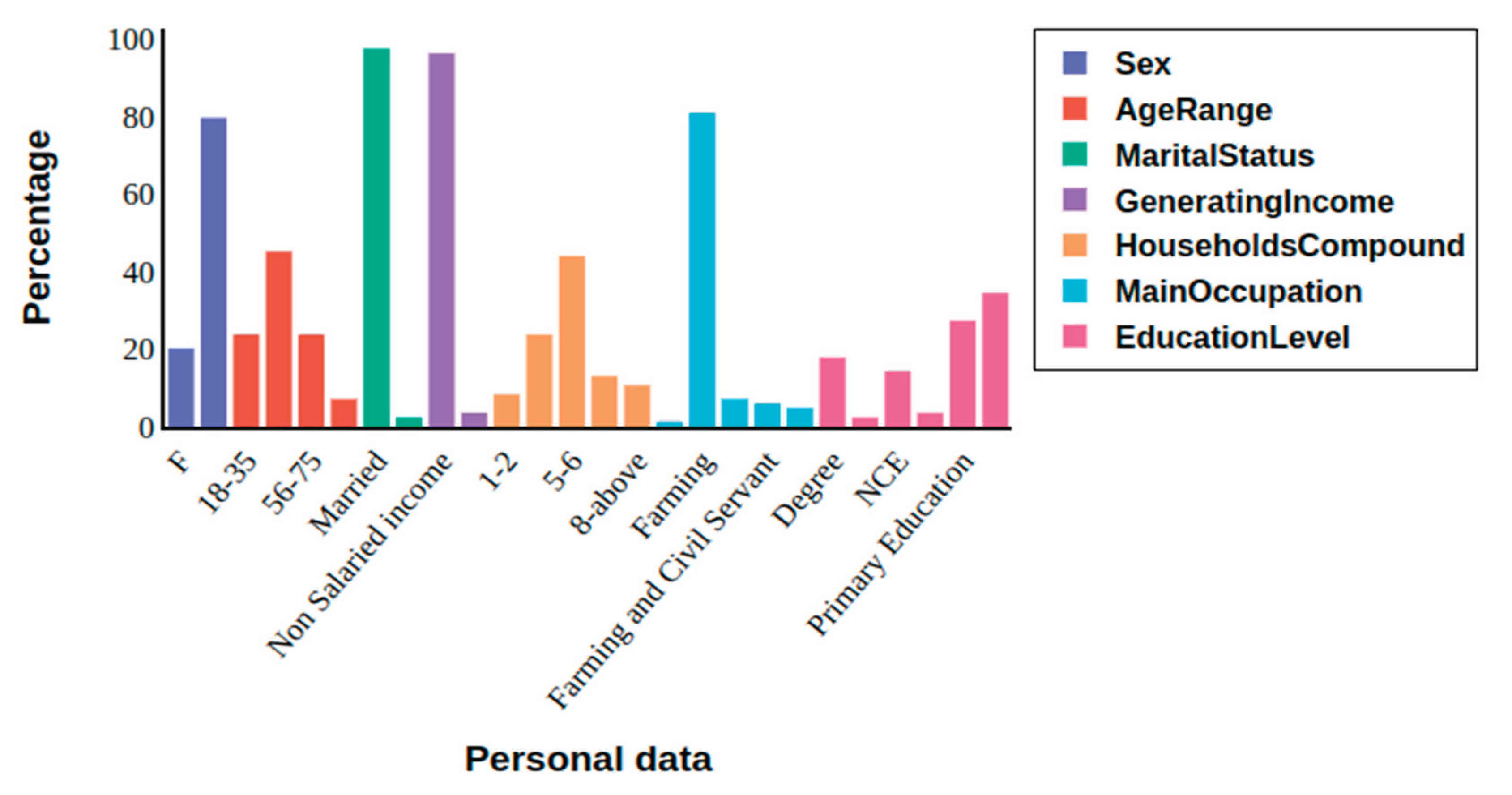
Appendix B. Table 1. Doma Key Stakeholders Quotes Identifying Their Perceived Drivers of Forest Change in The Study Area from 1966–2000 (the Past) and from 2001–2022 (the Present), Based on Data from KII
| Participants’ Group | Key response (s) Agriculture |
| Local People | "The forest reserve has undergone substantial changes primarily due to the expansion of agricultural activities, as it has become a site for farming. Local communities cultivate a variety of crops in the area, including yam, groundnut, melon, maize, guinea corn, beans, soya beans, and others. This agricultural activity has contributed to the transformation of the forest landscape, reflecting a shift in land use driven by local livelihoods and subsistence needs" (Doma Local People KII 001, June 2022) |
| Local Leaders | “Agriculture is the major driver for the forest changes in this area because trees have been cut down to give space for farming activities since the 1960s until date; it is the source of livelihood for our communities, which is why we exploit these forest reserve resources and cultivate crops within the area. We, the community, have no alternative sources of income for our livelihoods. We depend on the forest reserve for our source of income and livelihood” (Doma Local leaders KII 001, June 2022) |
| Key response (s) poverty | |
| Local people | “Poverty is a significant driver of changes in the forest reserve. People exploit this forest to sustain their livelihoods and meet economic needs, with community members often clearing parts of the forest to access and utilize its resources” (KII Doma Local person 005, June 2022). |
| Key response (s) Lumbering | |
| Local people | The practice of timber extraction has persisted for thousands of years, focusing on economically valuable tree species like Iroko, mahogany, ebeche, shear butter trees. These trees have been harvested to meet the substantial demand for timber exports, serving diverse applications abroad and within local communities. This industry includes forest-dwelling individuals and private commercial enterprises, generating revenue for governmental bodies. Consequently, these logging operations have significantly altered the designated forest reserve (Doma Local People KII 003, June 2022) |
| Key response (s) Fuelwood/Charcoal | |
| Local Community Leaders | "Local communities frequently harvest trees, such as Vitellaria paradoxa (shea tree), Daniellia oliveri (African Copaiba balsam tree), and Prosopis africana, for firewood and high-quality charcoal due to their dense wood and high calorific value. This targeted harvesting has significantly contributed to the depletion of forest cover and resources in the reserve, driven by domestic use and economic necessities" (Doma, local community leader K II 004, June 2022) |
| Key response (s) Grazing | |
| Local people | "Grazing by herdsmen contributes to the destruction of the forest reserve; they move into the forestry area and cut down the trees and grasses to feed their animals', this reduces the composition and size of the forest reserves.; Their activities affect forest growth and cover" (Doma, Community people KII 003, June 2022) |
| Key response (s) Population | |
| Local Community Leaders | “Population growth has significantly impacted forest cover and ecosystem change, interacting with other environmental pressures and direct drivers. For example, the demand for livelihood sources is influenced by population growth. Prior to 1960, the population that led to extraction and degradation remained low. However, since 2000, deforestation has escalated, largely driven by rapid population growth within the state and local community areas” (Doma, local community leader KII 005, June 2022) |
| Key response (s) Government policies/ Governance |
|
| Local people | “Before now, government do take good care of the reserves but now less attention is given, so people go into the reserves and cut down trees in the reserve any time without any taken proper permission” (Doma local people KII 005, June 2022). |
| Key response (s) Settlement/Construction | |
| Local Leader | “Residential building is among other land uses that contribute to the change of the forest reserve because the first need of a man is shelter. Our people build within the forest reserve area before using the resources available on the reserves such as agriculture, timber and with the increasing of human population people clear forest area for more building” (Doma local leader, 002, June 2022) |
| Key response (s) Migration | |
| Local People | “People migrate from rural to rural areas for a greener pasture. For example, people migrate to our community in Doma, and we allow them to live with us, contributing to the pressure we receive on our forest cover and the forest resources for a livelihood. This help in contributing to the change in the forested area” (Doma local person KII 002, June 2022) |
| Key response (s) Corruption | |
| Local leaders | “The government forest officers assigned to monitor, manage, and enforce the forest laws against encroachments in this forest reserve encourage the community and even foreigners by collecting small bribes from them and then allowing them to enter the forest and degrade it for timber extraction, agricultural, and other uses, which leads to a high rate of cutting forest trees and a change in the forest reserves”. Doma local leader KII 003, June 2022) |
Appendix B. Table 2. Risha Key Stakeholders Quotes Identifying Their Perceived Drivers of Forest Change in the Study Area from 1966–2000 (the Past) and from 2001–2022 (the Present), Based on Data from KII
| Participants’ Group | Key response (s) Agriculture |
| Local People | "Agriculture activities have been the primary driver of forest changes in this reserve. Since the 1970s, extensive tree cover has been cut down to give space for farming activities. These practices are deeply intertwined with the livelihoods of local communities, as agriculture serves as the primary source of income and sustenance for many families. The community's reliance on forest resources is rooted in a lack of alternative economic opportunities, leading to the exploitation of the forest reserve for both agricultural cultivation and other livelihood needs". (Risha Local people KII 001, June 2022). |
| Community Leaders | “The forest reserve has changed due to agriculture expansion because we are farming there. We farm crops like yam, groundnut, melon, maize, guinea corn, beans, and soya beans and so on” (Risha Local leaders KII 001, June 2022) |
| Key response (s) Lumbering | |
| Local people | "Lumbering is one of the key contributors to human activities that lead to the degradation of forest reserve in this area. People often felling or cut down trees in and around protected forest areas, particularly to obtain timber for construction materials such as roofing houses. Over time, this persistent practice not only depletes tree populations but also undermines efforts to maintain the ecological balance and biodiversity within this reserve” (Risha, KII 004, June 2022). |
| “Valuable tree species, including mahogany, iroko, and others less commonly recognized, were heavily exploited by the community and the government for timber to meet housing, roofing, and construction demands. This large-scale deforestation significantly reduced forest cover, disrupting the ecological balance. The loss of these trees has had cascading effects on biodiversity, including wildlife displacement and depletion of other valuable species. As a result, these trees are now scarce around the reserve, highlighting the long-term consequences of unsustainable logging practices” (Risha, KII 002, June 2022) | |
| Key response (s) Charcoal production | |
| Local leaders | “Most of our people “indigenes” cut down trees to produce charcoal and firewood; also, the trees provide us with construction materials which we construct our houses and also sell to generate income for ourselves and our families, and I think it could be a crucial driver for the gazetted forest reserve changes” (Risha Community Leader KII 004, June 2022). |
| Key response (s) Population growth | |
| Local People | “Due to population increase, people started claiming ownership of land for farming purposes around 1998 to date of the forest reserves area” (Risha forest, Local person 003, (Female) KII July 2022). |
| Key response (s) Poverty | |
| Local people | “Poverty is one of the major drivers that led to changes in the forest reserves: we expand our agricultural land in the forest to get our livelihood since we have no good way of getting food or money to survive” (KII Risha Local people 005, June 2022) |
| Local leaders | "We can say poverty serves as a key driver of changes in forest reserves, as economically disadvantaged communities often resort to clearing forests to meet immediate needs. This includes expanding agricultural land to grow crops for subsistence and income generation, as well as extracting resources from forests to support livelihoods. These activities are frequently undertaken to ensure economic survival in the face of limited alternatives” (KII Risha Local leader 005, June 2022) |
| Key response (s) Government policies/ Governance | |
| Local people | “The government forest officers assigned to monitor, manage, and enforce the forest laws against encroachments in this forest reserve encourage the community and even foreigners by collecting small bribes from them and then allowing them to enter the forest and degrade it for timber extraction, agricultural, and other uses, which leads to a high rate of cutting forest trees and a change in the forest reserves” (Risha local people KII 004, June 2022). |
Appendix B. Table 3. Odu key Stakeholders Quotes Identifying Their Perceived Drivers of Forest Change in the Study Area from 1966–2000 (the Past) and from 2001–2022 (the Present), Based on Data from KII
| Participants’ Group | Key response (s) Agriculture |
| Local People | "Agriculture has contributed to forest changes here since the 1970s, as we depend on farming and forest resources for income and survival, with no alternative livelihoods" (Odu, Local Community People, KII 003, June 2022). |
| Community Leaders | “Agriculture is the major driver for the forest changes in this area because trees have been cut down to give space for farming activities since the 1960s until date; it is the source of livelihood for our communities, which is why we exploit these forest reserve resources and cultivate crops within the area. We, the community, have no alternative sources of income for our livelihoods. We depend on the forest reserve for our source of income and livelihood” (Doma Local leaders KII 001, June 2022) |
| Key response (s) Lumbering | |
| Local Community People | “Trees like mahogany, iroko and so on I don’t know their names, were selected and massively cut out for timbers for houses, roofing and other constructions, affecting trees cover in the forest and even wild animals and other valuable trees, now hardly you seem them in the forest” (Odu, Community People, KII 002, June 2022) |
| Local Community leaders | "There was an extensive exploitation of forest resources particularly trees such as mahogany, iroko, Parkia biglobosa, Gmelina, opepe and others whose names I cannot recall were selectively and extensively harvested for timber used in housing, roofing, and other construction purposes. This has significantly reduced tree cover in the forest, adversely affecting wildlife and other valuable tree species. Today, these trees are scarcely found in the forest" (Odu, Local People, KII 002, June 2022). |
| Key response (s) Fuelwood/Charcoal | |
| Local Community People | “Some of our people cut down trees for firewood and charcoal, targeting specific trees, which has depleted forest covers and resources from this reserve. For instance, tree species such as Vitellaria paradoxa (commonly known as shea tree), Daniellia oliveri (African Copaiba balsam tree), and Prosopis africana are frequently harvested for high-quality charcoal due to their dense wood and high calorific value. The widespread cutting and burning of these trees for charcoal for domestic use and economic gain” (Odu, Local Community People K II 005, June 2022). |
| Community leaders | “Our people cut and burn some of the tree species for charcoal., there are specific trees that we have for producing charcoal, and this may have contributed to the reduction of the forest” (Odu, Community leader K II 003, June 2022) |
| Key response (s) Grazing | |
| Local people | “Animals have been grazing around the reserve by Fulani [Herdsmen] over the parcel of land within the forest reserve area. The cattle and cows’ footsteps are overstepping the forest by feeding on the grass within the reserve area and cutting down branches of trees for their animals to feed on, and at times they even cut down the trunks for grazing purposes. Again, they cut down the trees to build their camps (houses), and now they are even going to the roots to uproot the trees (Odu, Local people KII 001, June 2022) |
| Local leaders |
Appendix B. Table 4. Government and Expert KII Key Stakeholders Quotes Identifying Their Perceived Drivers of Forest Change in the Study Area from 1966–2000 (the Past) and from 2001–2022 (the Present), Based on Data from KII.
| Participants’ Group | Key response (s) Agriculture |
| Government officials | “Farmlands are expanded in the reserve areas, and even the government has allowed Tungiya farming in the reserve, which was supposed to be protected. As such, most people begin to farm again around the area. Before the farm, they clear trees by cutting off trees’ vegetation cover and even burning them, which degrades the forest cover and also destroys soil organisms on the forest lands, which affects the growth of the forest trees in this forest reserves area (Government official KII 003,) June 2022). |
| Experts | |
| Key response (s) Lumbering | |
| Government official | “As forest communities population increases, people are erecting structures, they fell trees to produce timber to roof their houses, so this has contributed to the decline of the forest reserve in this area” (Government official, KII 002, June 2022) |
| Experts | "Logging activities have been there for thousands of years now, targeting some particular economic trees. They have been cut down due to high demand for these timbers' export for different uses and for the communities' uses. This activity involves both the individual in the forest communities and the private commercial that generate revenue for the government, which has a significant impact on the gazetted forest change in these areas" (Expert KII 001, June 2022). |
| Key response (s) Poverty | |
| Government official | “The one major activity for the forest reserve change is just poverty and that is the fact, the community people need money for livelihoods and economic means which result to clear forest around them for the resources uses” (KII Government official 005, June 2022) |
| Key response (s) Population growth | |
| Experts | "Population around this forest reserve areas has changed from 1959 till today in the forest communities. For example, the increased expansion and urbanization comes in; as a result, some of the villages that are used to be 300 square meters now will be 3000 square meters, also likely 500 people then, but today the population of the same place may be like 3500 persons, so as such, with human population increases, settlements growth is bound to occur, and settlements growth means encroaching into other land uses that were not residential, because the first need of a man is shelter, and in a shelter and then production which is within the forest reserve to extract raw material for the production of housing, timbers and leading to other activities as increasing human population results to increasing demand from people for other land use and human activities for livelihood which is the key driving forces of the forest change" (Expert KII 004, June 2022) |
| Key response (s) Government policies/ Governance | |
| Government Official | “Government policies are often contributing to deforestation in forest reserves. This is because these policies are not always implemented in a manner that aligns with the needs of the people for conservation. For instance, Nigeria's high cost of natural gas, cooking gas, and kerosene has led to a situation where poor residents in forest communities are forced to resort to forests for their energy needs. This has resulted in the degradation of the ecosystem and a change in the forest cover” (Government official KII 002, June 2022) |
| Key response (s) Settlement/Construction | |
| Government official | “Road construction and housing development, particularly around forest reserves like Doma and Risha, has increased due to growing socio-economic activities requiring infrastructure. This has led to significant degradation of these reserves through logging and timber use, causing extensive deforestation and heavily degrading parts of the forest for settlement and infrastructure development” (KII Government official 005, June 2022) . |
| Expert | “Recently, road construction in Nasarawa State has tended to increase around some forest reserves linked to socio-economic activities that lead to the demand of facilities such as stores, houses, and built-up products to help with socio-economy activities. This utilization of wood logs and timbers for construction affects our forest reserves. For Example, Doma road opens to Yalwa, which passes through the forest reserves, and massive destruction of forest for the road construction was done. This has greatly affected some portion of the forest in this area” (Expert KII 002, June 2022). |
| Key response (s) Insecurity thread | |
| Expert | "Some of these forests are the hiding place for criminals in the hiding zone. These people cut down vegetation cover around their communities to see their surroundings clearly for defend purposes" (Expert KII 001 June 2022). |
References
- Makunga, J.E.; Misana, S.B. The Extent and Drivers of Deforestation and Forest Degradation in Masito-Ugalla Ecosystem, Kigoma Region, Tanzania. Open Journal of Forestry 2017, 07, 285–305. [Google Scholar] [CrossRef]
- Dibaba, W.T.; Demissie, T.A.; Miegel, K. Drivers and implications of land use/land cover dynamics in Finchaa Catchment, Northwestern Ethiopia. Land 2020, 9, 1–20. [Google Scholar] [CrossRef]
- Seyam, M.M.H.; Haque, M.R.; & Rahman, M.M.; Rahman, M. M. Identifying the land use land cover (LULC) changes using remote sensing and GIS approach: A case study at Bhaluka in Mymensingh, Bangladesh. Case Studies in Chemical and Environmental Engineering 2023, 7, 100293. [Google Scholar] [CrossRef]
- Deng, M.; Hu, F.; Ma, W.; Yang, W.; & Luan, X.; Luan, X. Drivers and Dynamics of Forest and Grassland Ecosystems in the Altai Mountains: A Framework for National Park Conservation. Land 2024, 14, 48. [Google Scholar] [CrossRef]
- Oduro Appiah, J.; Agyemang-Duah, W.; Sobeng, A.K.; Kpienbaareh, D. Analysing patterns of forest cover change and related land uses in the Tano-Offin forest reserve in Ghana: Implications for forest policy and land management. Trees, Forests and People 2021, 5, Elsevier B. [Google Scholar] [CrossRef]
- Eludoyin, A.O. & Iyanda, O.O. Land cover change and forest management strategies in Ife nature reserve, Nigeria. GeoJournal 2019, 84, Springer Netherlands. [Google Scholar] [CrossRef]
- Arcidiaco, L.; & Corongiu, M.; Corongiu, M. Analysis of LULC Change Dynamics That Have Occurred in Tuscany (Italy) Since 2007. Land 2025, 14, 443. [Google Scholar] [CrossRef]
- Phiri, M.; Nyirenda, H. Assessment of land use change in the Thuma forest reserve region of Malawi, Africa. Environmental Research Communications 2022, 4, IOP Publishing. [Google Scholar] [CrossRef]
- Munthali, M.G.; Kindu, M.; Adeola, A.M.; Davis, N.; Botai, J.O. Solomon, N. (2022). Variations of ecosystem service values as a response to land use and land cover dynamics in central Malawi. Environment, Development and Sustainability, (June). [Online]. [CrossRef]
- Amoah, A.; Korle, K.; Kwablah, E. Asiama, R.K. Sustaining Protected Forests and Forest Resources in Ghana: An Empirical Evidence. Journal of Sustainable Forestry 2022, 00, Taylor & Francis.; 1–19. [Online]. [CrossRef]
- Keenan, R.J.; Reams, G.A.; Achard, F.; de Freitas, J.V.; Grainger, A.; Lindquist, E. Dynamics of global forest area: Results from the FAO Global Forest Resources Assessment 2015. Forest Ecology and Management Elsevier B.V.; 9–20. 2015, 352. [Google Scholar] [CrossRef]
- Ahammad, R.; Stacey, N.; Eddy, I.M.S.; Tomscha, S.A.; Sunderland, T.C.H. Recent trends of forest cover change and ecosystem services in the eastern upland region of Bangladesh. Science of the Total Environment 2019, 647, 379–389. [Google Scholar] [CrossRef]
- Diep, N.T.H.; Nguyen, N.T.; Diem, P.K.; & Nguyen, C.T.; Nguyen, C. T. Benefits and Trade-Offs from Land Use and Land Cover Changes Under Different Scenarios in the Coastal Delta of Vietnam. Land 2025, 14, 1063. [Google Scholar] [CrossRef]
- Meijaard, E.; Abram, N.K.; Wells, J.A.; Pellier, A.S.; Ancrenaz, M.; Gaveau, D.L.A.; Runting, R.K.; Mengersen, K. (2013). People’s Perceptions about the Importance of Forests on Borneo. PLoS ONE, 8. [Online]. [CrossRef]
- Zhang, M.; Chen, S.; & Liu, W.; Liu, W. Disentangling the complexity of regional ecosystem degradation: Uncovering the interconnected natural-social drivers of quantity and quality loss. Land 2023, 12, 1280. [Google Scholar] [CrossRef]
- Moutouama, F.T.; Biaou, S.S.H.; Kyereh, B.; Asante, W.A.; Natta, A.K. Factors shaping local people’s perception of ecosystem services in the Atacora Chain of Mountains, a biodiversity hotspot in northern Benin. Journal of ethnobiology and ethnomedicine 2019, 15, 1–10. [Google Scholar] [CrossRef] [PubMed]
- Ahrens, D.; Benedikter, S.; Giessen, L. ; (2025). Rethinking Synergies and Trade-Offs at the Forest-Sustainable Development Goals (SDGs) Nexus A Systematic Review. Sustainable Development.
- Capitani, C.; Van Soesbergen, A.; Mukama, K.; Malugu, I.; Mbilinyi, B.; Chamuya, N.; Kempen, B.; Malimbwi, R.; Mant, R.; Munishi, P. ; Scenarios of Land Use and Land Cover Change and Their Multiple Impacts on Natural Capital in Tanzania. Environmental Conservation 2019, 46, 17–24. [Google Scholar] [CrossRef]
- Sotirov, M.; Pokorny, B.; Kleinschmit, D.; Kanowski, P. (2020). International forest governance and policy: Institutional architecture and pathways of influence in global sustainability. Sustainability (Switzerland), 12. [Online]. [CrossRef]
- Scullion, J.J.; Vogt, K.A.; Drahota, B.; Winkler-Schor, S.; Lyons, M. (2019). Conserving the Last Great Forests: A Meta-Analysis Review of the Drivers of Intact Forest Loss and the Strategies and Policies to Save Them. Frontiers in Forests and Global Change, 2 (October), 1–12. [Online]. [CrossRef]
- Assessment, M.E. (2005). Ecosystems and human well-being: wetlands and water. World resources institute.
- Yang, W.; Dietz, T.; Kramer, D.B.; Ouyang, Z.; Liu, J. An integrated approach to understanding the linkages between ecosystem services and human well-being. Ecosystem health and sustainability Taylor & Francis. 2015, 1, 1–12. [Google Scholar] [CrossRef]
- Carpenter, A.; Peponis, J. Poverty and connectivity. The journal of space syntax 2010, 1, 108–120. [Google Scholar]
- Cantarello, E.; Lovegrove, A.; Orozumbekov, A.; Birch, J.; Brouwers, N.; Newton, A.C. Human impacts on forest biodiversity in protected walnut-fruit forests in Kyrgyzstan. Journal of Sustainable Forestry Taylor & Francis. 2014, 33, 454–481. [Google Scholar] [CrossRef]
- Jew, E.K.K.; Burdekin, O.J.; Dougill, A.J.; Sallu, S.M. Rapid land use change threatens the provisioning of ecosystem services in Miombo woodlands. Natural Resources Forum 2019, 43, 56–70. [Google Scholar] [CrossRef]
- Fasona, M.J.; Akintuyi, A.O.; Adeonipekun, P.A.; Akoso, T.M.; Udofia, S.K.; Agboola, O.O.; Ogunsanwo, G.E.; Ariori, A.N.; Omojola, A.S.; Soneye, A.S.; et al. (2020). Recent trends in land-use and cover change and deforestation in south–west Nigeria. Geo Journal, (October). [Online]. [CrossRef]
- Lim, C.L.; Prescott, G.W.; De Alban, J.D.T.; Ziegler, A.D.; Webb, E.L. Untangling the proximate causes and underlying drivers of deforestation and forest degradation in Myanmar. Conservation Biology 2017, 31, 1362–1372. [Google Scholar] [CrossRef]
- Guerra, A.; Roque, F. de O.; Garcia, L.C.; Ochao-Quintero, J.M.O.; Oliveira, P.T.S. de, Guariento, R.D.; Rosa, I.M.D. (2020). Drivers and projections of vegetation loss in the Pantanal and surrounding ecosystems. Land Use Policy, 91 (April 2020). [Online]. [CrossRef]
- Rheynaldi, P.K.; Endri, E.; Minanari, M.; Ferranti, P.A.; & Karyatun, S.; Karyatun, S. Energy price and stock return: Evidence of energy sector companies in Indonesia. International Journal of Energy Economics and Policy 2023, 13, 31–36. [Google Scholar] [CrossRef]
- Chunwate, B.T.; Yahaya, S.; Samaila, I.K.; Ja’afaru, S.W. Analysis of Urban Land Use and Land Cover Change for Sustainable Development: A Case of Lafia, Nasarawa State, Nigeria. Journal of Geographic Information System 2019, 11, 347–358. [Google Scholar] [CrossRef]
- Wehkamp, J.; Aquino, A.; Fuss, S.; & Reed, E.W.; Reed, E. W. Analyzing the perception of deforestation drivers by African policy makers in light of possible REDD+ policy responses. Forest Policy and Economics 2015, 59, 7–18. [Google Scholar] [CrossRef]
- Geist, H.J.; Lambin, E.F. Proximate Causes and Underlying Driving Forces of Tropical Deforestation Tropical forests are disappearing as the result of many pressures, both local and regional, acting in various combinations in different geographical locations. Bio Science Oxford University Press. 2020, 52, 143–150. [Google Scholar]
- Hosonuma, N.; Herold, M.; De Sy, V.; De Fries, R.S.; Brockhaus, M.; Verchot, L.; Angelsen, A.; Romijn, E. (2012). An assessment of deforestation and forest degradation drivers in developing countries. Environmental Research Letters, 7. [Online]. [CrossRef]
- Chirwa, P.W.; Mahamane, L.; Kowero, G. Forests, people, and environment: some African perspectives. Southern Forests 2017, 79, 79–85. [Google Scholar] [CrossRef]
- Soul, M. (2016). Impact of Land Use and Climate Change on Vegetation Dynamics of Doma Forest Reserve in Nasarawa State, Nigeria Dynamics of Doma Forest Reserve in Nasarawa State, Nigeria by West African Science Service Centre on Climate Change and. (September 2015).
- Fasona, M.; Adedoyin, B.; Sobanke, I. (2020b). Status and Drivers of spatial change of forest reserves and protected areas in the Selected State of Southwest Nigeria: A case study of Ogun, Osun and Oyo state Nigeria. 3.
- Olorunfemi, I.E.; Fasinmirin, J.T.; Olufayo, A.A.; Komolafe, A.A. GIS and remote sensing-based analysis of the impacts of land use/land cover change (LULCC) on the environmental sustainability of Ekiti State, southwestern Nigeria. Environment, Development and Sustainability Springer Netherlands. 2020, 22, 661–692. [Google Scholar] [CrossRef]
- Geidam, K.K.; Adnan, N.A.; Alhaji Umar, B. Analysis of Land Use Land Cover Changes Using Remote Sensing Data and Geographical Information Systems (GIS) at an Urban Set up of Damaturu, Nigeria. Journal of Science and Technology 2020, 12, 24–37. [Google Scholar] [CrossRef]
- Adedeji, O.H.; Tope-Ajayi, O.O.; Abegunde, O.L. Assessing and Predicting Changes in the Status of Gambari Forest Reserve, Nigeria Using Remote Sensing and GIS Techniques. Journal of Geographic Information System 2015, 07, 301–318. [Google Scholar] [CrossRef]
- Gong, P.; Li, X.; Wang, J.; Bai, Y.; Chen, B.; Hu, T.; Liu, X.; Xu, B.; Yang, J.; Zhang, W.; et al. (2020). Annual maps of global artificial impervious area (GAIA) between 1985 and 2018. Remote Sensing of Environment, 236 (October 2019), Elsevier.; p.111510. [Online]. [CrossRef]
- Thasi, K.; Martin, T.; Gueguim, D. Spatial and temporal dynamics of anthropogenic threats on the biodiversity of Virunga National Park. International Journal of Forest, animal and Fisheries Research 2021, 5, 10–17. [Google Scholar] [CrossRef]
- Walters, B.B. Explaining land use and forest change: more theory or better methodology? Landscape Ecology Springer Netherlands. 2022, 2. [Google Scholar] [CrossRef]
- Valcourt, N.; Walters, J.; Carlson, S.; Safford, K.; Hansen, L.; Russell, D. . & Kroner, R.G. Mapping drivers of land conversion among smallholders: A global systems perspective. Agricultural Systems 2024, 218, 103986. [Google Scholar]
- Inuwa, N.; Adamu, S.; Sani, M.B.; Modibbo, H.U. Natural resource and economic growth nexus in Nigeria: a disaggregated approach. Letters in Spatial and Resource Sciences Springer. 2022, 15, 17–37. [Google Scholar] [CrossRef]
- Atim, G.; Gbamwuan, A. (2022). Farmer-Herder Conflicts and the Socio-Economic Predicaments of Women in North Central Nigeria. Advances in Social Sciences Research Journal, 9.
- Chunwate, B.T.; Simon Yerima, Y.; Samuel, A. A.; Simon Yerima, C.B.; & Samuel, Ρ. A. Y. ; & Samuel, Ρ. A. Y. (2021). Analysis of land-use conflict between farmers and pastoralists in Gwagwalada Area Council of Abuja, Nigeria.
- Madu, I.A.; & Nwankwo, C.F. Spatial pattern of climate change and farmer–herder conflict vulnerabilities in Nigeria. GeoJournal 2021, 86, 2691–2707. [Google Scholar] [CrossRef]
- Ogu, M.I. (2020). Resurgent Violent Farmer-Herder Conflicts and ‘Nightmares’ in Northern Nigeria.
- Ihemezie, E.J.; Dallimer, M. (2021). Stakeholders’ perceptions on agricultural land-use change, and associated factors, in Nigeria. Environments - MDPI, 8. [Online. [CrossRef]
- Okoli, A.C.; & Atelhe, G.A. Nomads against natives: A political ecology of herder/farmer conflicts in Nasarawa state, Nigeria. American international journal of contemporary research 2014, 4, 76–88. [Google Scholar]
- FAO. (2020). Food and Agriculture Organization of the United Nations: Global Forest Resources Assessment 2020: Terms and Definition FRA. Global Forest Resources Assessment -Terms and Definitions, p.32. [Online]. Available online: http://www.fao.org/forestry/58864/en/.
- Agidi, V.; Hassan, S.; Baleri, T.; Yilgak, J. Effect of Inter-annual Rainfall Variability on Precipitation Effectiveness in Nasarawa State, Nigeria. Journal of Geography, Environment and Earth Science International 2018, 14, 1–21. [Google Scholar] [CrossRef]
- Ahungwa, G.T.; Umeh, J.C.; Muktar, B.G. Empirical analysis of food security status of farming households in Benue state, Nigeria. OSR Journal of Agriculture and Veterinary Science 2013, 6, 57–62. [Google Scholar]
- Fabolude, G.O.; David, O.A.; Akanmu, A.O.; Nakalembe, C.; Komolafe, R.J.; & Akomolafe, G.F. Impacts of anthropogenic disturbance on forest vegetation cover, health, and diversity within Doma forest reserve, Nigeria. Environmental Monitoring and Assessment 2023, 195, 1270. [Google Scholar] [CrossRef]
- Buba, T. Impact of Different Types of Land Use on Pattern of Herbaceous Plant Community in the Nigerian Northern Guinea Savanna. Journal of Agriculture and Ecology Research International 2015, 4, 151–165. [Google Scholar] [CrossRef]
- Federal Department of Forestry Nigeria. (2019). National Forest Reference Emission Level (FREL) for the Federal Republic of Nigeria. (December), 1–54.
- Saidu, S.; Yahaya, T.I. (2020). Spatio-temporal Variations in Mean Heavy Rainfall Days over the Guinea Savanna Ecological Zone of Nigeria. 1, 1–13.
- Abdulaziz, H.; Johar, F.; Majid, M.R.; Medugu, N.I. Protected area management in Nigeria: A review. Journal Teknologi (Sciences & Engineering) 2015, 77, 31–40. [Online]. [CrossRef]
- Forest law, B.P.S. of N. G. (1968). Forest law, Benue Plateau State of Nigeria Gazetted No.8, Vol.2, 14. 2.
- Shrestha, K.; Shakya, B.; Adhikari, B.; Nepal, M.; & Shaoliang, Y. Ecosystem services valuation for conservation and development decisions: A review of valuation studies and tools in the Far Eastern Himalaya. Ecosystem Services 2023, 61, 101526. [Google Scholar] [CrossRef]
- Gao, H.; Xiao, Y.; Van Koppen, C.S.A.; & Ouyang, Z. Local perceptions of ecosystem services and protection of culturally protected forests in southeast China. Ecosystem Health and Sustainability 2018, 4, 299–309. [Google Scholar] [CrossRef]
- Ganesha, H.R.; & Aithal, P.S. How to Choose an Appropriate Research Data Collection Method and Method Choice Among Various Research Data Collection Methods and Method Choices During Ph.D. Program in India? International Journal of Management, Technology, and Social Sciences 2022, 7, 455–489. [Google Scholar] [CrossRef]
- Muhati, G.L.; Olago, D.; Olaka, L. Land use and land cover changes in a sub-humid Montane Forest in an arid setting: A case study of the Marsabit forest reserve in northern Kenya. Global Ecology and Conservation 2018, 16, Elsevier Ltd. [Google Scholar] [CrossRef]
- Charmaz, K. “With constructivist grounded theory you can’t hide”: Social justice research and critical inquiry in the public sphere. Qualitative inquiry 2020, 26, 165–176. [Google Scholar] [CrossRef]
- Mammides, C.; Ma, J.; Bertzky, B.; Langner, A. Global Patterns and Drivers of Forest Loss and Degradation Within Protected Areas. Frontiers in Forests and Global Change 2022, 5, Frontiers. [Google Scholar] [CrossRef]
- Sahuri, S.; Fikri, S.; Fikri, D.; Armi, I. An Identification of Deforestation in Protected Forest Areas Using Land Cover mapping (A Case Study of Bukit Suligi Protected Forest). The South East Asian Journal of Advance Engineering and Technology 2023, 1, 1–9. [Google Scholar] [CrossRef]
- Worboys, G.L.; Lockwood, M.; Kothari, A.; Feary, S.; Pulsford, I. (2015). Protected area governance and management, Anu Press.
- Kayombo, C.J.; Ndangalasi, H.J.; Mligo, C.; Giliba, R.A. Analysis of Land Cover Changes in Afromontane Vegetation of Image Forest Reserve, Southern Highlands of Tanzania. Scientific World Journal 2020, 2020, Hindawi. [Online]. [CrossRef]
- Kissinger, M. Herold, V.D.S. (2017). Drivers of Deforestation and Forest Degradation in Bhutan. A synthesis report for REDD+ Policymakers, 6 (March). [Online]. Available online: http://www.era-mx.org/biblio/Drivers of deforestation and forest degradation.pdf.
- Martini, E.; Pagella, T.; Mollee, E.; van Noordwijk, M. (2023). Relational values in locally adaptive farmer-to-farmer extension: how important? Current Opinion in Environmental Sustainability, 65 (Figure 1), Elsevier.; p.101363. [Online]. [CrossRef]
- Pancholi, R.; Yadav, R.; Gupta, H.; Vasure, N.; Choudhary, S.; Singh, M.N.; & Rastogi, M. The role of agroforestry systems in enhancing climate resilience and sustainability-a review. Int. J. Environ. Clim. Change 2023, 13, 4342–4353. [Google Scholar] [CrossRef]
- Ankomah, F.; Kyereh, B.; Ansong, M.; Asante, W. (2020). Forest management regimes and drivers of forest cover loss in forest reserves in the high forest zone of Ghana. International Journal of Forestry Research, 2020. [Online]. [CrossRef]
- Kimutai, D.K.; Watanabe, T. Forest-cover change and participatory forest management of the lembus forest, Kenya. Environments 2016, 3, MDPI. [Google Scholar] [CrossRef]
- Orimoogunje, O.O.I. Forest cover changes and land use dynamics in Oluwa forest reserve, Southwestern Nigeria. Journal of Landscape Ecology(Czech Republic) 2014, 7, 25–44. [Google Scholar] [CrossRef]
- Jeminiwa, O.R.; Jeminiwa, M.S.; Taiwo, D.M.; Dauda, M.; Olaotilaaro, S.O. Assessment of Forest Degradation Indices in Mokwa Forest Reserve, Niger State, Nigeria. Journal of Applied Sciences and Environmental Management 2020, 24, 1351–1356. [Google Scholar] [CrossRef]
- Sedano, F.; Silva, J.A.; Machoco, R.; Meque, C.H.; Sitoe, A.; Ribeiro, N.; Anderson, K.; Ombe, Z.A.; Baule, S.H.; Tucker, C.J. The impact of charcoal production on forest degradation: A case study in Tete, Mozambique. Environmental Research Letters 2016, 11, IOP Publishing. [Google Scholar] [CrossRef]
- Ekpo, A.S.; Mba, E.H. (2020). Assessment of Commercial Charcoal Production Effect on Savannah Woodland of Nasarawa State, Nigeria. Journal of Geography, Environment and Earth Science International, (April), 74–82. [Online]. [CrossRef]
- Alhassan, J.; Ofosu, A.; Iddrisu, S.; Kofi Garsonu, E. Wood fuel producers’ insight on the environmental effects of their activities in Ghana. Journal of Sustainable Forestry Taylor & Francis. 2023, 42, 607–623. [Google Scholar] [CrossRef]
- Kattel, D.B.; Yao, T.; Yang, W.; Gao, Y.; Tian, L. ; Comparison of temperature lapse rates from the northern to the southern slopes of the Himalayas. International Journal of Climatology 2015, 35, 4431–4443. [Google Scholar] [CrossRef]
- Felix, L.; Houet, T.; Verburg, P.H. ; Mapping biodiversity and ecosystem service trade-offs and synergies of agricultural change trajectories in Europe. Environmental Science & Policy 2022, 136, 387–399. [Google Scholar]
- Salisu, A.T.; Barau, A.S.; Carr, J.A.; Chunwate, B.T.; Jew, E.K.K.; Kirshner, J.D.; Marchant, R.A.; Tomei, J.; Stringer, L.C. The forgotten bread oven: local bakeries, forests and energy transition in Nigeria. Regional Environmental Change 2024, 24, Springer Berlin Heidelberg. [Online]. [CrossRef]
- John, E.; Bunting, P.; Hardy, A.; Roberts, O.; Giliba, R.; Silayo, D.S. Modelling the impact of climate change on Tanzanian forests. Diversity and Distributions Wiley Online Library. 2020, 26, 1663–1686. [Google Scholar] [CrossRef]
- Del Socorro, L.F. Guardians of the green: An essay on the impacts of climate change on forest ecosystems and its mitigation. Davao Research Journal 2023, 14, 108–112. [Google Scholar] [CrossRef]
- Rotich, B. Forest conservation and utilization in Embobut, Cherangani hills, Kenya. International Journal of Natural Resource Ecology and Management 2019, 4, 7. [Google Scholar] [CrossRef]
- Kariuki, R.W.; Western, D.; Willcock, S.; Marchant, R. (2021b). Assessing interactions between agriculture, livestock grazing and wildlife conservation land uses: A historical example from east Africa. Land, 10, 1–19. [Online]. [CrossRef]
- Antoneli, V.; Thomaz, E.L.; Bednarz, J.A. The Faxinal System: Forest fragmentation and soil degradation on the communal grazing land. Singapore Journal of Tropical Geography 2019, 40, 34–49. [Google Scholar] [CrossRef]
- Chen, X.; Shang, X.; Fan, F.; Zheng, Y.; Zhao, L.; Sun, H.; Li, S.; Zhang, L. (2023). Impacts of livestock grazing on blue-eared pheasants (Crossoptilon auritum) survival in subalpine forests of Southwest China. Integrative Conservation, Wiley Online Library.
- MacKinnon, K.; Richardson, K.; MacKinnon, J. Protected and other conserved areas: ensuring the future of forest biodiversity in a changing climate. International Forestry Review Commonwealth Forestry Association. 2020, 22, 93–103. [Google Scholar] [CrossRef]
- Chen, Y.; & Xu, E. ; & Xu, E. (2023b). The Spatiotemporal Change in Land Cover and Discrepancies within Different Countries on the Qinghai–Tibet Plateau over a Recent 30-Year Period. Land, 12, 1797.
- Matlhodi, B.; Kenabatho, P.K.; Parida, B.P.; Maphanyane, J.G. Evaluating land use and land cover change in the Gaborone dam catchment, Botswana, from 1984–2015 using GIS and remote sensing. Sustainability 2019, 11, 5174. [Google Scholar] [CrossRef]
- Mucova, S.A.R.; Leal Filho, W.; Azeiteiro, U.M.; Pereira, M.J. Assessment of land use and land cover changes from 1979 to 2017 and biodiversity & land management approach in Quirimbas National Park, Northern Mozambique, Africa. Global ecology and conservation 2018, 16, e00447. [Google Scholar]
- Jellason, N.P.; Robinson, E.J.Z.; Chapman, A.S.A.; Neina, D.; Devenish, A.J.M.; Po, J.Y.T.; Adolph, B. A systematic review of drivers and constraints on agricultural expansion in sub-Saharan Africa. Land 2021, 10, 1–17. [Google Scholar] [CrossRef]
- Ojiija, F.; Swai, E.; Mwakalapa, E.B.; Mbije, N.E.J. Impacts of emerging infrastructure development on wildlife species and habitats in Tanzania. Journal of Wildlife and Biodiversity 2024, 8, 365–384. [Google Scholar]
- Alamgir, M.; Campbell, M.J.; Sloan, S.; Suhardiman, A.; Supriatna, J.; Laurance, W.F. High-risk infrastructure projects pose imminent threats to forests in Indonesian Borneo. Scientific reports 2019, 9, 140. [Google Scholar] [CrossRef]
- Ojija, F.; Nicholaus, R. Impact of Climate Change on Water Resources and its Implications on Biodiversity: A Review. East African Journal of Environment and Natural Resources 2023, 6, 15–27. [Google Scholar] [CrossRef]
- Fischer, J.; Riechers, M.; Loos, J.; Martin-Lopez, B.; Temperton, V.M. ; Making the UN decade on ecosystem restoration a social-ecological endeavour. Trends in ecology & evolution 2021, 36, 20–28. [Google Scholar]
- Joppa, L.N.; Pfaff, A. Global protected area impacts. Proceedings of the Royal Society B: Biological Sciences 2011, 278, 1633–1638. [Google Scholar] [CrossRef] [PubMed]
- Robson, J.P.; Klooster, D.J. Migration and a New Landscape of Forest Use and Conservation. Environmental Conservation 2019, 46, 1–8. [Google Scholar] [CrossRef]
- Ward, C.; Stringer, L.; Holmes, G. (2018b). Changing governance, changing inequalities: Protected area co-management and access to forest ecosystem services: a Madagascar case study. Ecosystem Services, 30 (January), The Authors.; 137–148. [Online]. [CrossRef]
- Domínguez, L.; Luoma, C. Decolonising conservation policy: How colonial land and conservation ideologies persist and perpetuate indigenous injustices at the expense of the environment. Land 2020, 9, 11–14. [Google Scholar] [CrossRef]
- Bertzky, B.; Corrigan, C.; Kemsey, J.; Kenney, S.; Ravilious, C.; Besançon, C.; Burgess, N. (2012). Protected Planet Report 2012: tracking progress towards global targets for protected areas. Protected Planet Report 2012: tracking progress towards global targets for protected areas.; Chemical Programme of the United Nations Environment Programme.
- Duguma, L.A.; Atela, J.; Ayana, A.N.; Alemagi, D.; Mpanda, M.; Nyago, M.; Minang, P.A.; Nzyoka, J.M.; Foundjem-Tita, D.; Ntamag-Ndjebet, C.N. (2018). Community forestry frameworks in sub-Saharan Africa and the impact on sustainable development. Ecology and Society, 23. [Online]. [CrossRef]
- Olaniyi, O.E.; Akinsorotan, O.A.; Zakaria, M.; Martins, C.O.; Adebola, S.I.; Oyelowo, O.J. (2019). Taking the edge off host communities’ dependence on protected areas in Nigeria. IOP Conference Series: Earth and Environmental Science, 269. [Online]. [CrossRef]
- Plata-Rocha, W.; Monjardin-Armenta, S.A.; Pacheco-Angulo, C.E.; Rangel-Peraza, J.G.; Franco-Ochoa, C.; Mora-Felix, Z.D. Proximate and underlying deforestation causes in a tropical basin through specialized consultation and spatial logistic regression modeling. Land 2021, 10, 1–18. [Google Scholar] [CrossRef]
- Munthali, M.G.; Davis, N.; Adeola, A.M.; Botai, J.O.; Kamwi, J.M.; Chisale, H.L.W.; Orimoogunje, O.O.I. Local perception of drivers of Land-Use and Land- Cover change dynamics across Dedza district, Central Malawi region. Sustainability (Switzerland) 2019, 11, 1–25. [Google Scholar] [CrossRef]
- Nerfa, L.; Rhemtulla, J.M.; Zerriffi, H. Forest dependence is more than forest income: Development of a new index of forest product collection and livelihood resources. World Development 2020, 125, Elsevier Ltd. [Google Scholar] [CrossRef]
- Morales-Hidalgo, D.; Oswalt, S.N.; Somanathan, E. Status and trends in global primary forest, protected areas, and areas designated for conservation of biodiversity from the Global Forest Resources Assessment 2015. Forest Ecology and Management 2015, 352, Elsevier. [Google Scholar] [CrossRef]
- Ladan, S.I. Forests and Forest Reserves as Security Threats in Northern Nigeria. European Scientific Journal December 2014 edition 2014, 10, 120–142. [Google Scholar]
- Lunstrum, E.; Ybarra, M. Deploying difference: Security threat narratives and state displacement from protected areas. Conservation and Society 2018, 16, JSTOR. [Google Scholar] [CrossRef]
- Brandt, J.S.; Butsic, V.; Schwab, B.; Kuemmerle, T.; Radeloff, V.C. The relative effectiveness of protected areas, a logging ban, and sacred areas for old-growth forest protection in southwest China. Biological Conservation Elsevier. 2015, 181, 1–8. [Google Scholar] [CrossRef]
- Isyaku, U. (2021). What motivates communities to participate in forest conservation? A study of REDD+ pilot sites in Cross River, Nigeria. Forest Policy and Economics, 133 (February), Elsevier B.V.; p.102598. [Online]. [CrossRef]
- Miranda, L.S.; Imperatriz-Fonseca, V.L.; Giannini, T.C. Climate change impact on ecosystem functions provided by birds in southeastern Amazonia. Plos one 2019, 14, Public Library of Science San Francisco, CA USA.; p.e0215229.
- MacKinnon, K.; Dudley, N.; Sandwith, T. Natural solutions: protected areas helping people to cope with climate change. Oryx Cambridge University Press. 2011, 45, 461–462. [Google Scholar] [CrossRef]
- Ranius, T.; Widenfalk, L.A.; Seedre, M.; Lindman, L.; Felton, A.; Hämäläinen, A.; Filyushkina, A.; Öckinger, E. Protected area designation and management in a world of climate change: A review of recommendations. Ambio 2023, 52, 68–80. [Google Scholar] [CrossRef]
- Senganimalunje, T.C.; Chirwa, P.W.; Babalola, F.D.; Graham, M.A. Does participatory forest management program lead to efficient forest resource use and improved rural livelihoods? Experiences from Mua-Livulezi Forest Reserve, Malawi. Agroforestry Systems 2016, 90, 691–710. [Google Scholar] [CrossRef]
- Bhatt, R.P. (2022). Impact on Forest and vegetation due to human interventions. In: Vegetation dynamics, changing ecosystems and human responsibility. IntechOpen.
- Indarto, J.; Mutaqin, D.J. (2016). An overview of theoretical and empirical studies on deforestation. Journal of International Development and Cooperation, 22 (1 & 2), 107–120. [Online].
- Scheren, P.; Tyrrell, P.; Brehony, P.; Allan, J.R.; Thorn, J.; Chinho, T.; Katerere, Y.; Ushie, V.; Worden, J.S.; Oliveira Cruz, C.; et al. (2021). Defining Pathways towards African Ecological Futures. [Online]. [CrossRef]
- Tesfaye, G.; Teketay, D.; Fetene, M.; & Beck, E. Regeneration of seven indigenous tree species in a dry Afromontane forest, southern Ethiopia. Flora-Morphology, Distribution, Functional Ecology of Plants 2010, 205, 135–143. [Google Scholar] [CrossRef]
- Ngurno, A.W.; Pagella, T.; Mollee, E.; & Stringer, L.C. (2025). A trilateral network for agroforestry and integrated regenerative landscape management to support climate resilient development and food security.
Figure 1.
Map of Africa with Nigeria showing the geographical position of Nasarawa State and its administrative subdivisions.
Figure 1.
Map of Africa with Nigeria showing the geographical position of Nasarawa State and its administrative subdivisions.
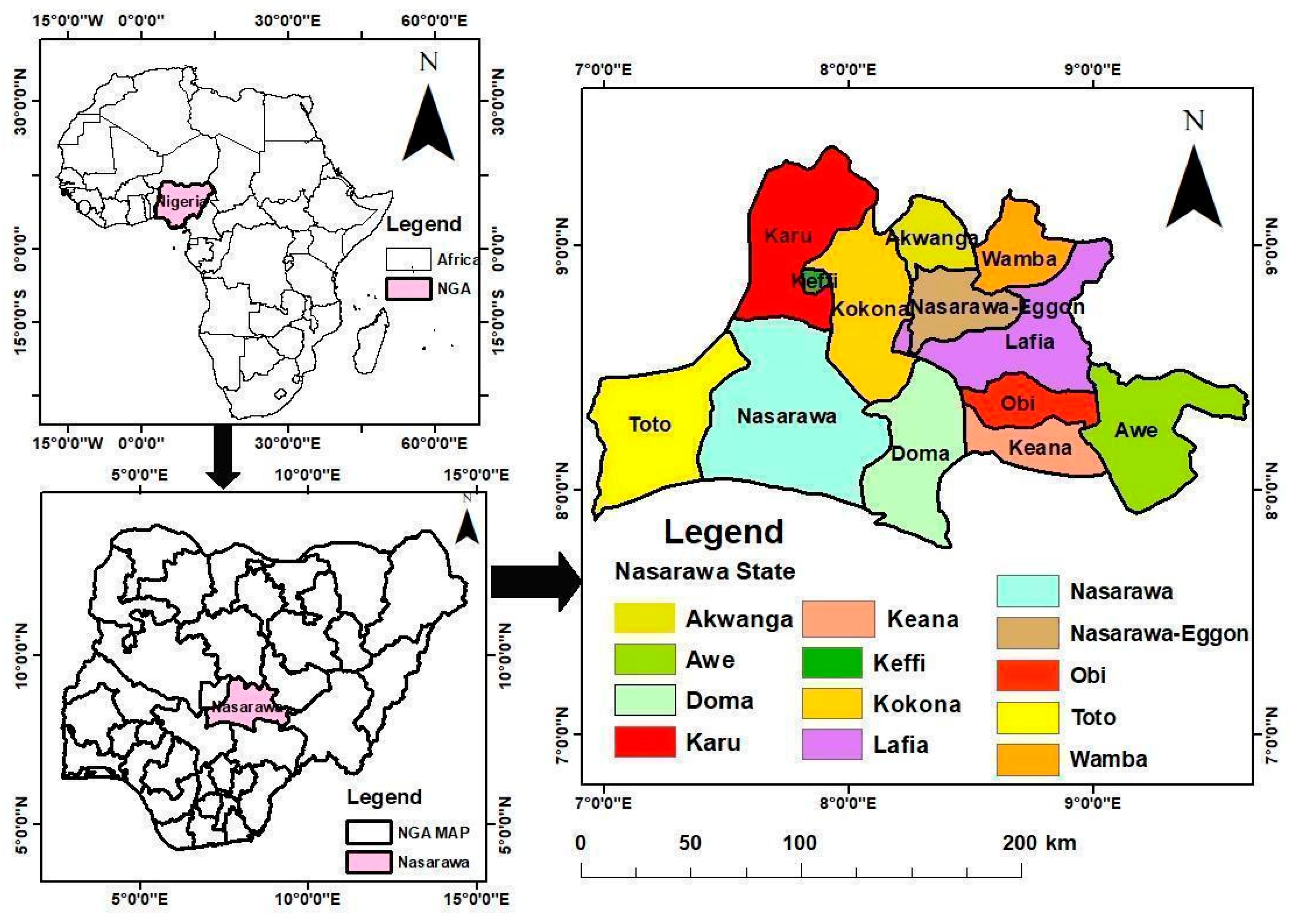
Figure 2.
Nasarawa State map showing the gazetted forest reserve distribution for 1966. This was an extraction from the Nasarawa shapefile from the Ministry of Environment, Abuja, and Nasarawa Geographic Information Service, 2020.
Figure 2.
Nasarawa State map showing the gazetted forest reserve distribution for 1966. This was an extraction from the Nasarawa shapefile from the Ministry of Environment, Abuja, and Nasarawa Geographic Information Service, 2020.
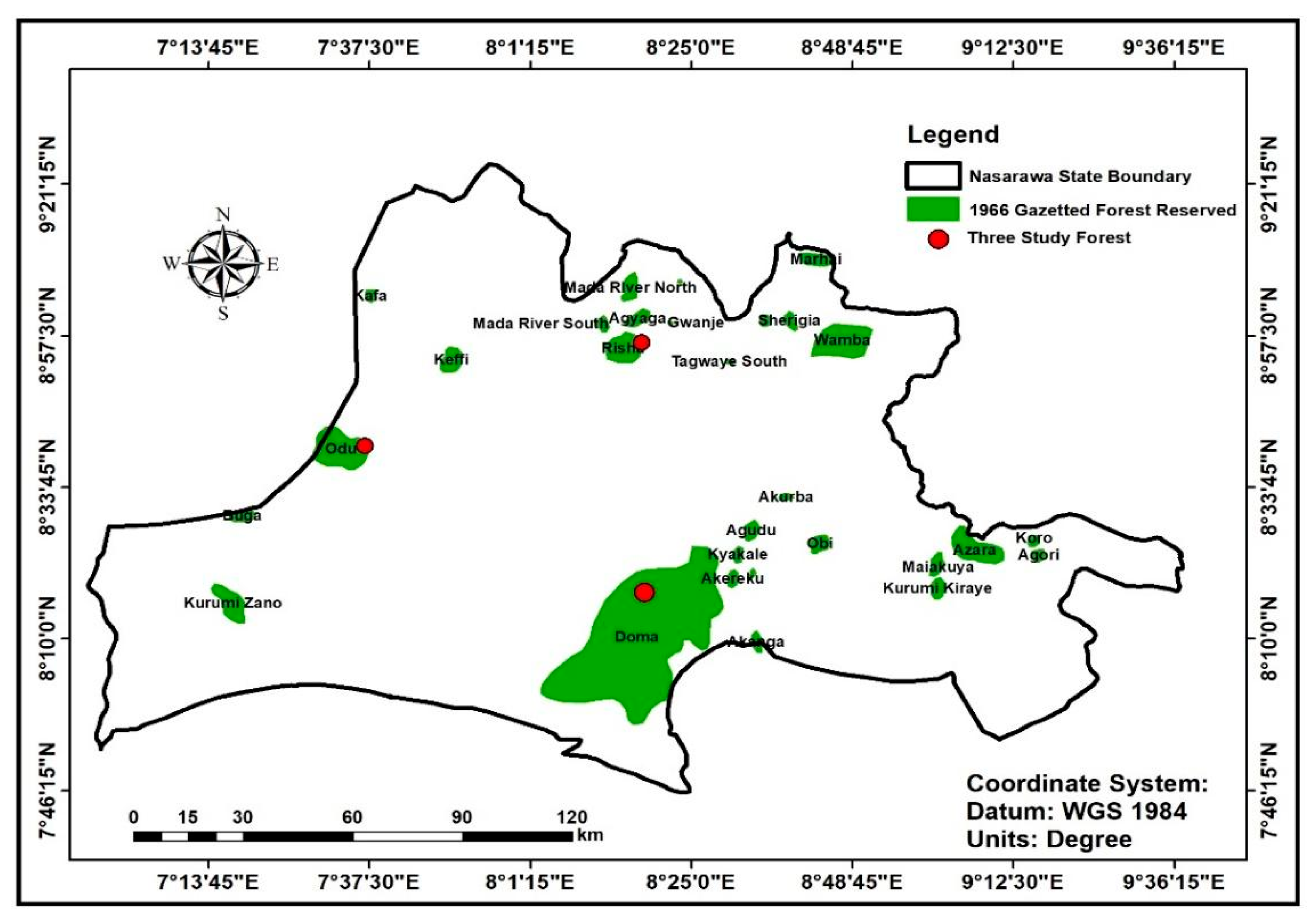
Figure 3.
Comparative responses on the perceived major direct drivers of gazetted forest change in the three gazetted forests in Nasarawa State.
Figure 3.
Comparative responses on the perceived major direct drivers of gazetted forest change in the three gazetted forests in Nasarawa State.
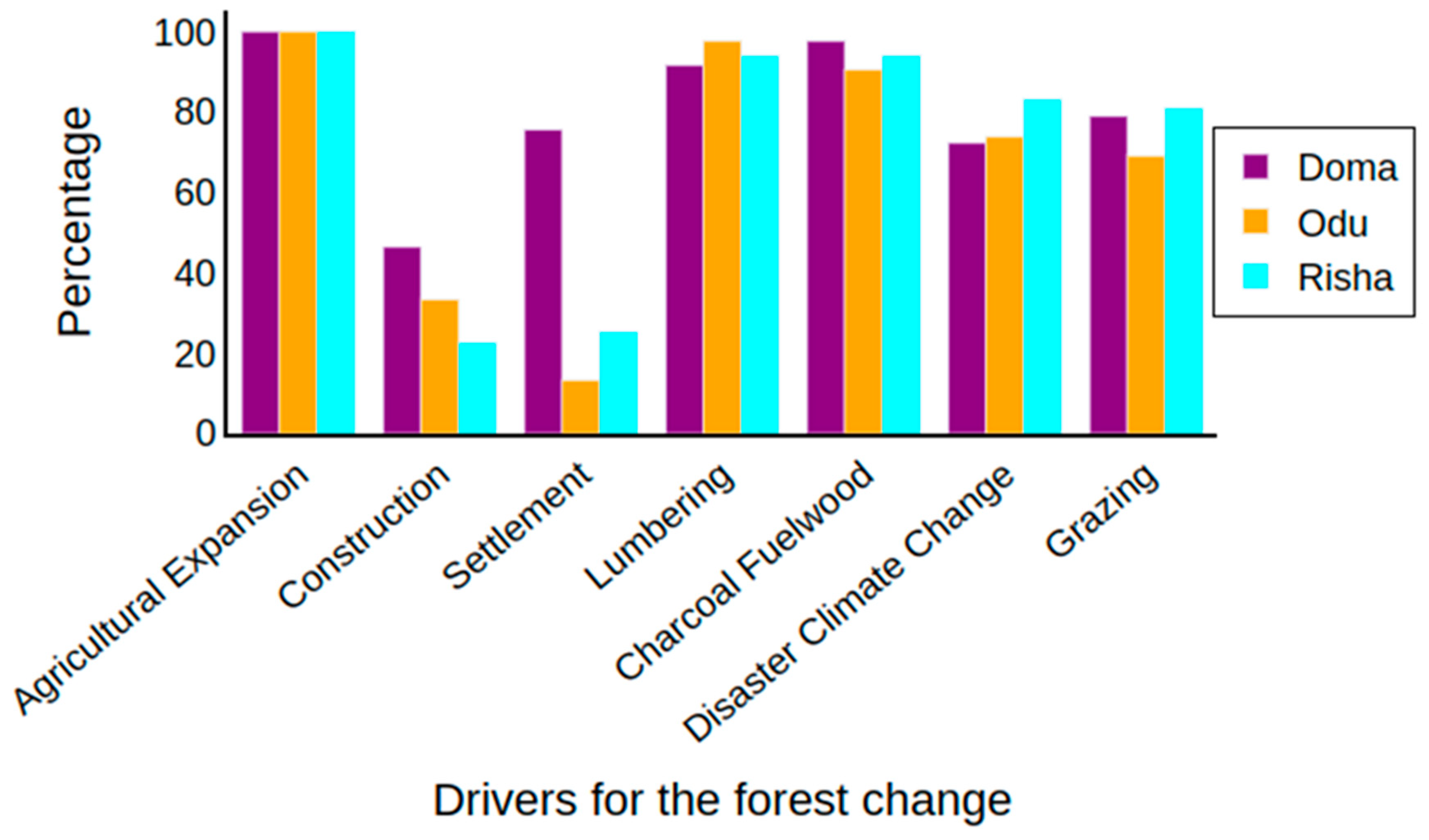
Figure 4.
Comparative responses analysis of human activities around the three gazetted forest reserves in Nasarawa State.
Figure 4.
Comparative responses analysis of human activities around the three gazetted forest reserves in Nasarawa State.
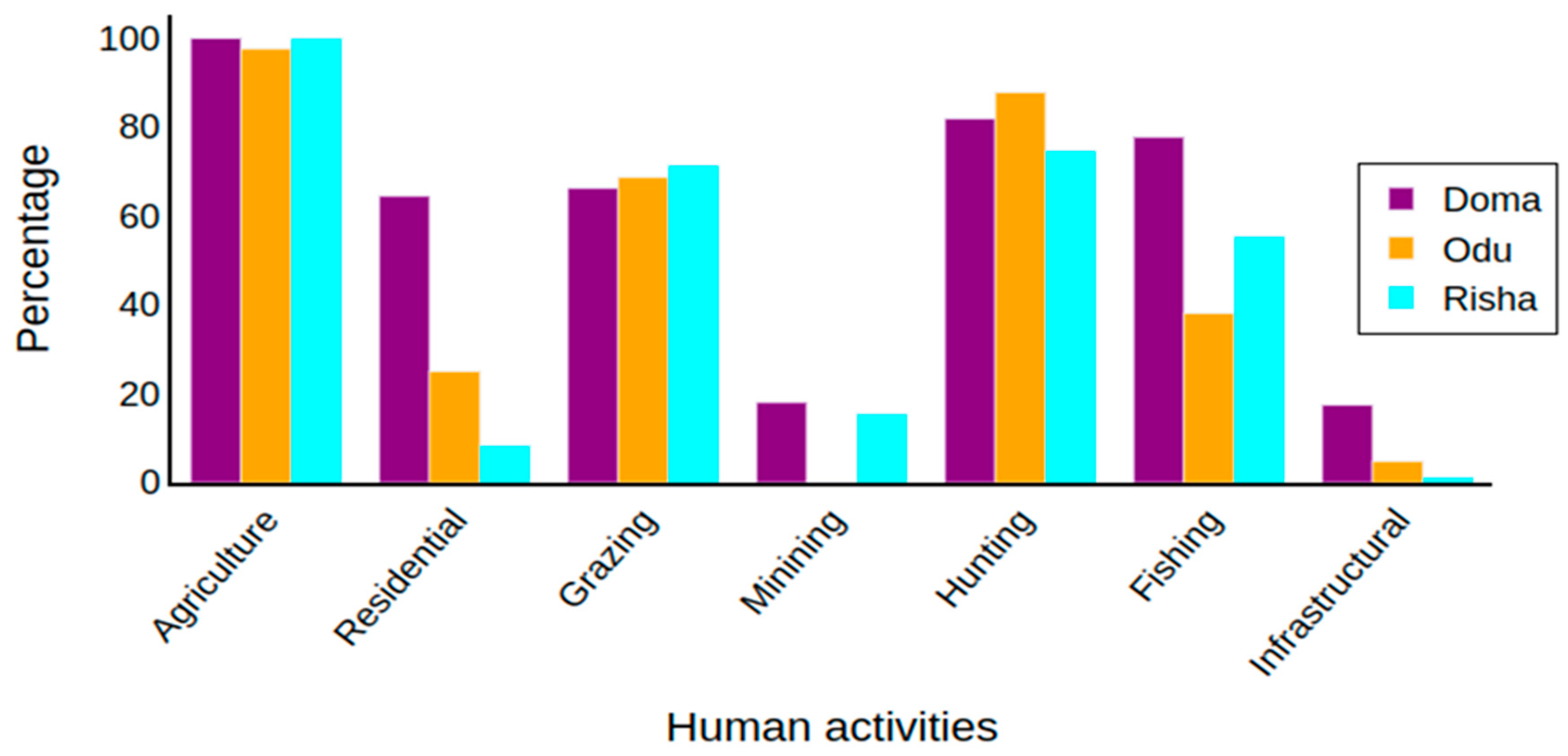
Figure 6.
Population trends for the study area (Nasarawa state) for the study years, 1966-2020.Sources: website: https://www.nationalpopulation.gov.ng.
Figure 6.
Population trends for the study area (Nasarawa state) for the study years, 1966-2020.Sources: website: https://www.nationalpopulation.gov.ng.
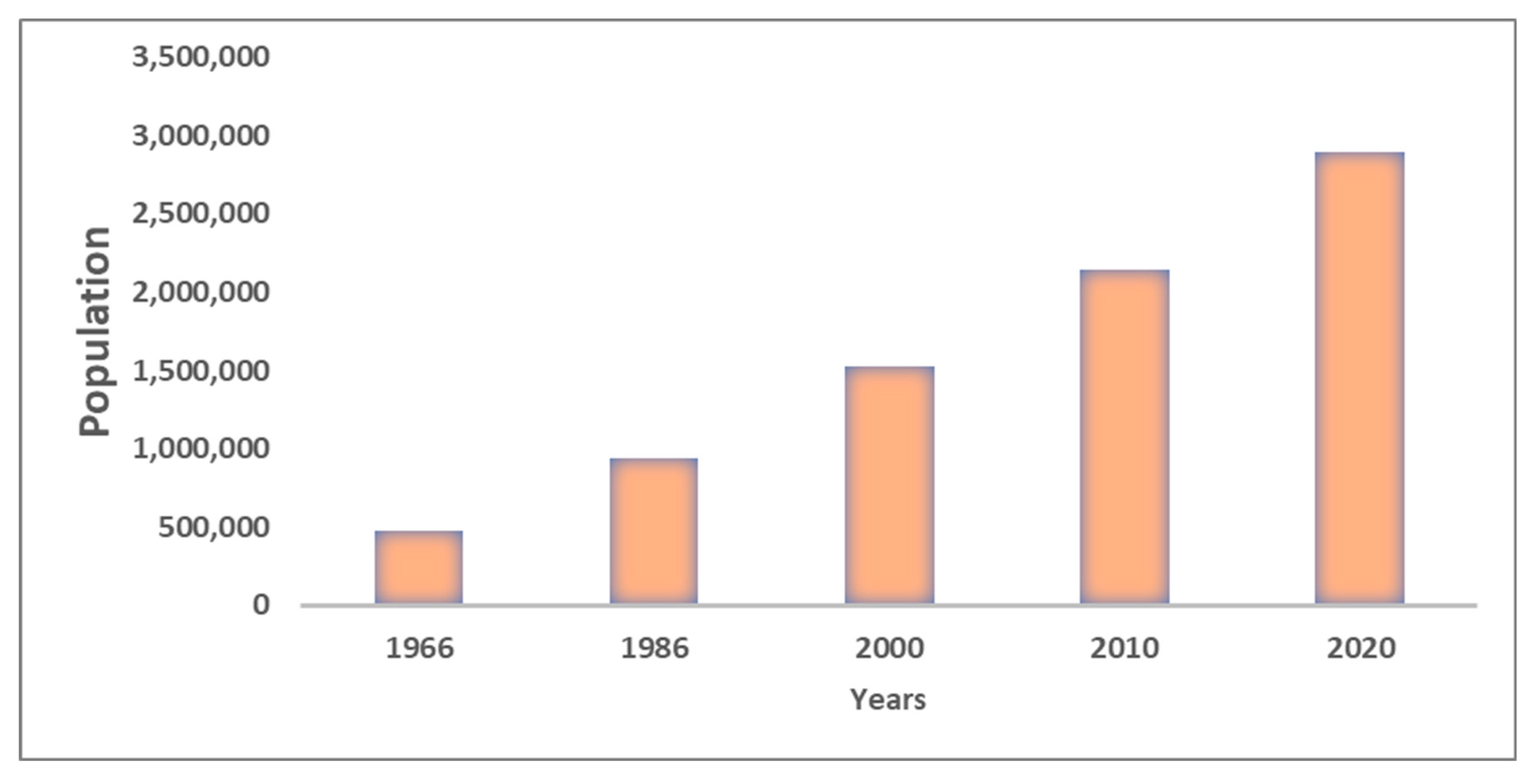
Figure 7.
The study area’s annual rainfall trend for 1986-2020 (Lafia Station). Source: Nigeria Meteorological Agency, Abuja, 2022.
Figure 7.
The study area’s annual rainfall trend for 1986-2020 (Lafia Station). Source: Nigeria Meteorological Agency, Abuja, 2022.
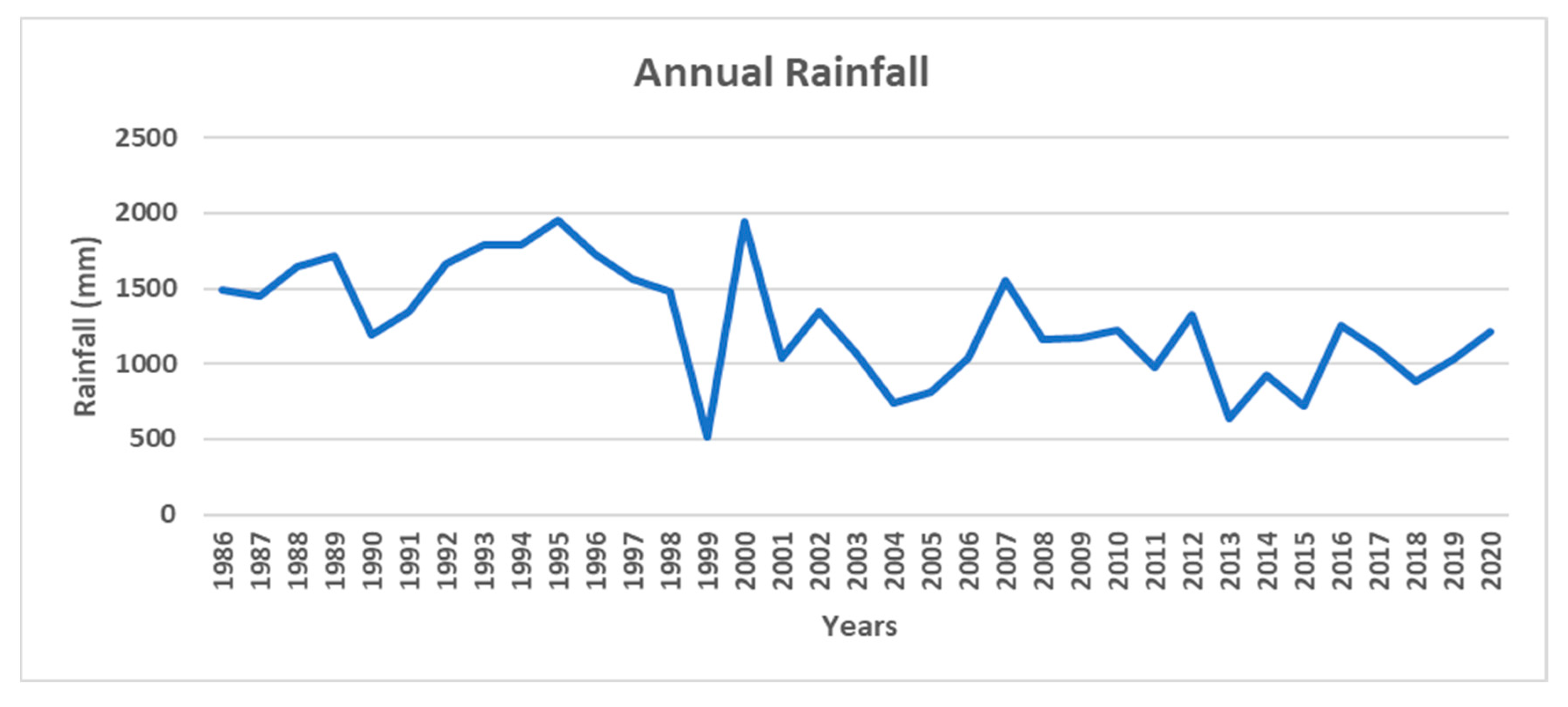
Figure 8.
The study area’s annual temperature trend for 1986-2020 (Lafia Station). Source: Nigeria Meteorological Agency, Abuja, 2022.
Figure 8.
The study area’s annual temperature trend for 1986-2020 (Lafia Station). Source: Nigeria Meteorological Agency, Abuja, 2022.
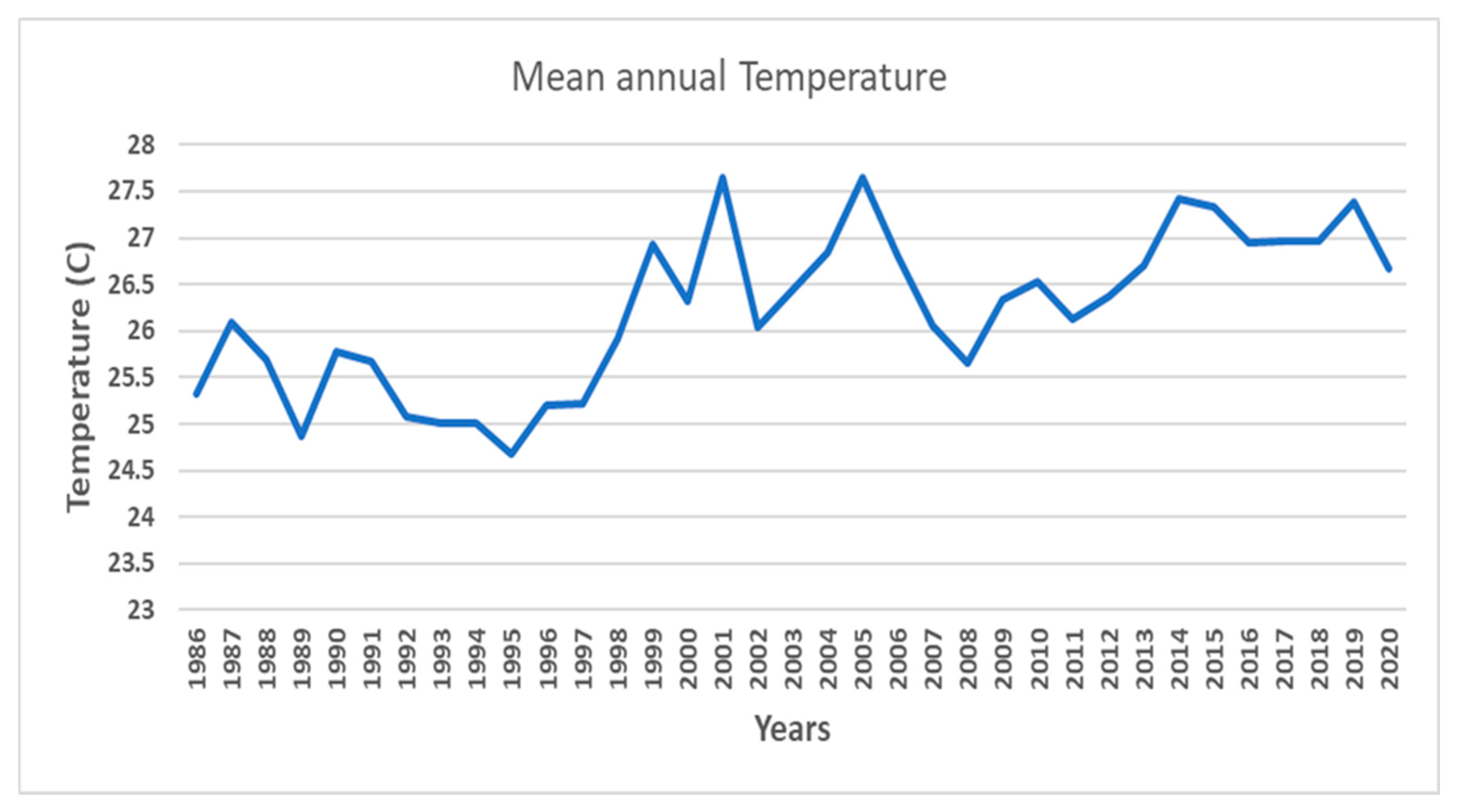
Table 1.
Data collection methods and sampling for the Household Questionnaire, the Key Informant Interviews (KIIs) and Focus Group Discussion (FGDs) used in the study.
Table 1.
Data collection methods and sampling for the Household Questionnaire, the Key Informant Interviews (KIIs) and Focus Group Discussion (FGDs) used in the study.
| Method | Type of respondent | Sample size and number of participants |
Sampling approach |
|---|---|---|---|
| Interviews | Four Groups’ Stakeholders | Local leaders 15 Local people 15 Policymakers 5 Experts 5 Total 40 |
Snowball sampling method |
| FGDs | Four Group Stakeholders | Local leaders 15 Local people 15 Policymakers 5 Experts 5 Total 40 |
Snowball sampling method |
| Household Questionnaire | Local Community Household survey | Doma Forest Reserve 84 Risha Forest Reserve 84 Odu Forest Reserve 84 Total 252 |
Multi-stage sample method |
Table 2.
Stakeholder groups involved in KII and FGDs and their description.
| Stakeholder Groups | Description of the stakeholder group |
|---|---|
| Local people | These are the forest users in the communities; they interact frequently with the forest for resources to derive immediate benefits for their livelihoods within their forest communities and include farmers, hunters, charcoal producers and timber contractors |
| Local leaders | These stakeholders are responsible for protecting their local environment, through management of forest use, land ownership and disputes, and local regulations. This group includes Traditional Rulers, Village Heads, Youth Leaders, Women Leaders and Market Leaders. |
| Government officials | These are government custodians who monitor and analyse forest uses, generate funds for the government, maintain forest-designated areas, record forest activities and take legal action against forest law violations. The participants from this group were from Nasarawa State Ministry of Environment and Natural Resources |
| Experts | These are independent experts that advocate for forest and land use for sustainability and advise the government and the people to understand forest policy implementation strategies, considering their impact on the environment, and particularly the importance and role of forests in environmental sustainability. This group includes land-use planners, environmentalists, geographers, and foresters in academic and forestry institutions. |
Disclaimer/Publisher’s Note: The statements, opinions and data contained in all publications are solely those of the individual author(s) and contributor(s) and not of MDPI and/or the editor(s). MDPI and/or the editor(s) disclaim responsibility for any injury to people or property resulting from any ideas, methods, instructions or products referred to in the content. |
© 2025 by the authors. Licensee MDPI, Basel, Switzerland. This article is an open access article distributed under the terms and conditions of the Creative Commons Attribution (CC BY) license (http://creativecommons.org/licenses/by/4.0/).
Copyright: This open access article is published under a Creative Commons CC BY 4.0 license, which permit the free download, distribution, and reuse, provided that the author and preprint are cited in any reuse.


