
Submitted:
22 April 2025
Posted:
22 April 2025
You are already at the latest version
Abstract
This study presents findings from an ongoing investigation of the recently discovered Rhizolith Petrified Forest of Chania, located at Stavros in the Akrotiri peninsula of Crete, Greece. Unlike most known petrified forests that primarily preserve tree trunks, this site uniquely features an abundance of rhizoliths—fossilized root systems preserved through calcium carbonate mineralization. The rhizoliths exist within aeolianite formations along the coastal front, with diverse morphologies and sizes ranging from small trace-like forms to massive, branched structures exceeding one meter in length. The site also contains in-situ petrified trunks, calcrete formations, and biokarstic dissolution features that further enhance its scientific value. Microscopic examination of rhizolith samples has revealed valuable information about their internal structure, showing clear biogenic characteristics. The exceptional preservation of both below-ground and above-ground plant components provides critical insight into the Quaternary paleoenvironment, including vegetation structure, soil stabilization processes, and paleoclimatic conditions. The alternating layers of aeolianites and paleosols suggest cyclical environmental changes, with periods of active dune formation alternating with more stable conditions allowing soil development and vegetation establishment. This comprehensive study places the Stavros rhizoliths in a global context, comparing them with similar features documented at other sites worldwide, and establishes the site as one of substantial paleoenvironmental and geological importance.
Keywords:
Rhizoliths
; Petrified Forest
; aeolianite
; fossilized root systems
; historical quarry
1. Introduction
Bronze Age antiquities in the Chania region of Crete, Greece have been studied since the late 19th century, but significant archaeological discoveries began primarily in the mid-1960s. The Akrotiri peninsula, surveyed extensively through the Chania Archaeological Survey Project, has revealed over 245 prehistoric sites. Initial settlements date to the Neolithic era, including the earliest known site in western Crete. While the Neolithic era saw relative isolation, by the Final Neolithic period there was evidence of increased interaction with regions such as the Cyclades and Anatolia, indicated by new pottery forms. The Early Bronze Age marked a period of heightened activity on Akrotiri, with increased settlements indicating emerging social hierarchies and extensive regional and interregional contacts. The presence of imported pottery and abundant Melian obsidians further confirm extensive external interactions during this time. Although the Middle Bronze Age exhibited reduced external contact, Akrotiri still experienced internal prosperity, indicated by the expansion and proliferation of settlements. During the Late Bronze Age, activity on Akrotiri peaked, with settlement numbers reaching approximately 150. This period saw significant urban development and economic vibrancy, highlighted by archaeological finds such as Linear A and B tablets. However, rural settlements declined, potentially due to urban migration or settlement nucleation, reflecting changes in settlement patterns and population dynamics [1].
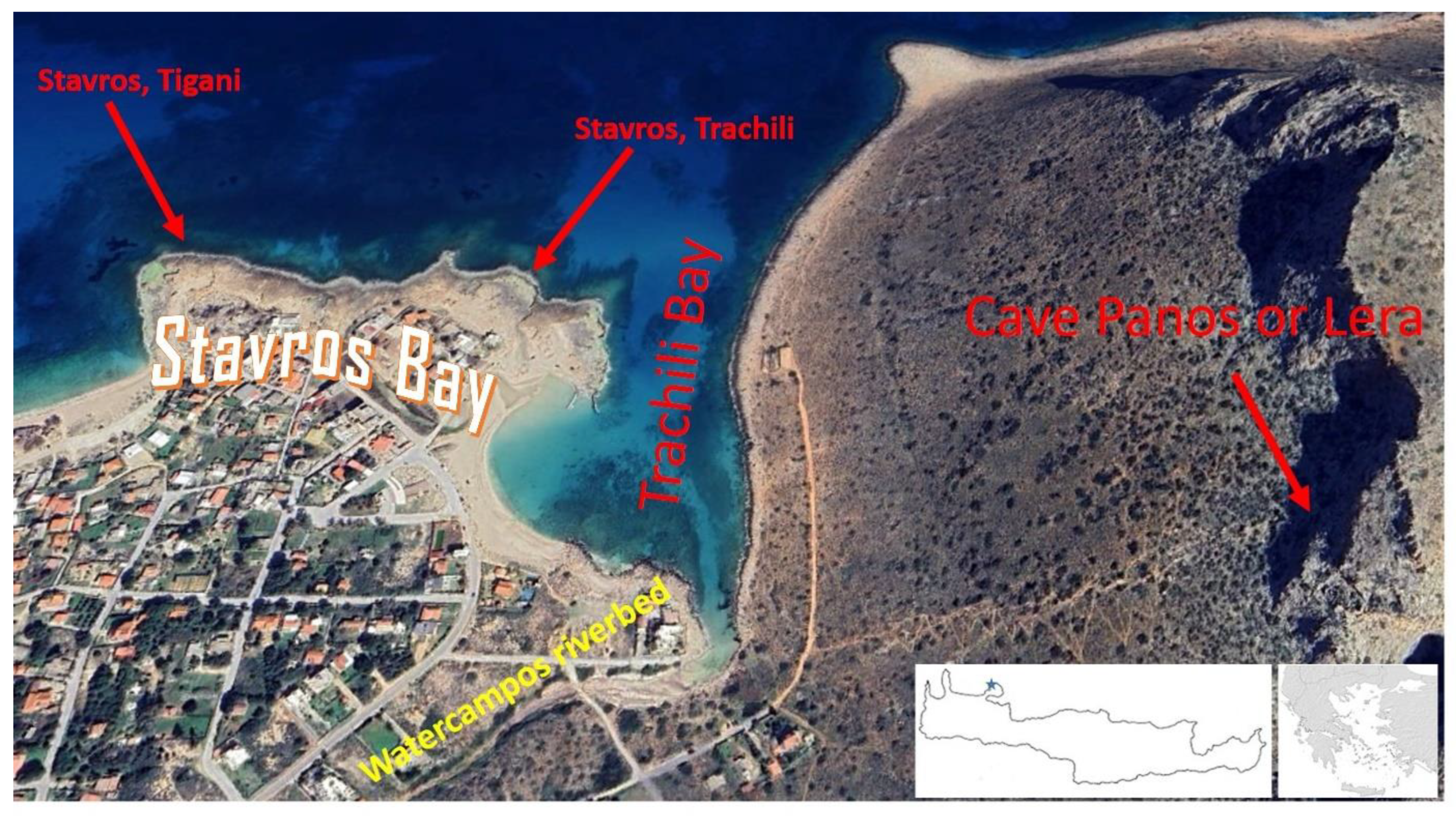
Figure 1.
The settlement of Stavros in the northwestern area of Akrotiri. On the right is the mountain range that
hosts the Panos or Lera cave, on the west the bay of Trachili where the river Nerokampos (Watercampos) flows
and the two parts (east and west) of the aeolianite quarry. Modified background from Google Earth.
The Lera Cave, located on the steep mountain massif of Bardia east of the closed Trachili Bay, served as an important cult site dedicated to the Nymphs and Pan. Archaeological evidence from the 5th-4th century BC reveals numerous ceramic materials with graffito dedications to these deities, found around the cave’s internal freshwater lake and spring. The assemblage includes Attic red-figure and black-gloss pottery, locally produced cups, lamps, and terracotta figurines. Most terracotta figurines came from Attic workshops, depicting primarily seated female deities, Silenoi, and „temple boy” figures. The cult at Lera shows strong similarities to Attic counterparts, which were also situated near caves and freshwater springs and characterized by similar offerings. The archaeological evidence suggests that an older indigenous fertility cult was replaced by this Attic-influenced worship of the Nymphs and Pan around the 5th century BC. After the 4th century BC, dedications ceased, making it difficult to trace the cult’s further development [2].
In the northwestern area of the Akrotiri peninsula, the coastal zone surrounding the settlement of Stavros, west of Trachili Bay, has come to be called Stavros Bay. Τhe wider Stavros bay area hosts one of Crete’s most significant quarry region. Extractive operations at this site trace their origins to the Minoan period, continued through the Middle Ages under Venetian oversight [3,4] and persist into the modern era. This quarry region is documented in the Corpus of ancient quarries with two locations: „417. Location: Stavros, Tigani” and „418. Location: Stavros, Trachili” [5].
The iconic Stavros quarry region—famed as a filming location for Zorba the Greek during the 1960s—has yielded aeolianite, a porous calcareous sandstone. This distinctive lithology formed through aeolian processes and the lithification of skeletal remains from marine organisms, shaping the region’s unique geomorphology.
This site is particularly noteworthy for its extensive preservation of root systems (rhizoliths) rather than just trunks, making it unique among Greek petrified forests and rare globally. The discovery occurred within and adjacent to Venetian quarries, where coastal aeolianites have preserved these ancient plant remains. The latter has been interpreted as vestiges of a coastal „alsyllion” - a paleo-woodland that once thrived in this region [6]. Petrified forests provide crucial windows into past ecosystems, preserving evidence of ancient flora and environmental conditions. While Greece hosts several documented petrified trees and forests, most notably in Lesvos, Limnos, Evros, and Kastoria [7,8,9] these primarily consist of silicified tree trunks preserved through volcanic processes. The recently identified Rhizolith Petrified Forest at Stavros in the Akrotiri peninsula of Chania presents a distinctly different preservation mechanism, with calcium carbonate mineralization as the primary fossilization process.
This paper presents a relatively wide range of findings from an ongoing investigation of a newly discovered Rhizoliths Petrified Forest of Chania, at Stavros, in the Akrotiri peninsula, Chania, Greece. Unlike most known petrified forests that primarily preserve tree trunks, this site uniquely features an abundance of rhizoliths—fossilized root systems preserved through calcium carbonate mineralization The rhizoliths exist within aeolianite formations along the coastal front, with diverse morphologies and sizes. Various biokarstic features, including dissolution pipes, rock pools, as well as calcrete horizons, and fossilized trunks, stumps and tree branches further characterize this site.
2. Geological Outline of the Akrotiri Peninsula
The Akrotiri peninsula, located near Chania on the island of Crete, extends northeastwards and covers about 100 km². The peninsula’s geomorphology comprises three distinct regions: rugged mountainous terrain in the northeast, a karstified stepped plain called „kampos” in the southwest, and a predominantly steep, rocky coastline with scattered sandy beaches and small harbors. Geologically, Akrotiri is divided into two main areas: the northeast consists primarily of karstified Mesozoic age recrystallised carbonate rocks, characterized by dramatic landscapes including sinkholes and dolines. The southwest is dominated by Neogene marly limestones (Figure 2 and Figure 3).
The study area is specifically located in the northwestern part of the Akrotiri peninsula, around Stavros village, within and around the Venetian quarry, extending along the coastal front over an area exceeding 700 meters in the western part of Trachili Bay. More specifically, the impermeable basement in the wider area of Akrotiri consists of a sequence of marble layers with metachert nodules of variable size and shape belonging to the metamorphic sequence of the Plattenkalk Group. This basement is in tectonic contact with the highly fractured overlain carbonates of the Trypali Unit [10]. Based on newer work for the wider study area [11] and personal field work, the surrounding hills to the east of the area are composed of recrystallized carbonate rocks with intense fragmentation and texture resembling the semi-metamorphosed carbonate formations of the Trypali Unit, rather than the limestones of the Tripolis zone as indicated on the existing geological map of the Chania sheet (produced by the former Institute of Geology and Subsurface Research (IGSR) [12] (Figure 2).
The geological boundary between the older Mesozoic carbonate rocks and the younger Mio-Pliocene deposits stretches along the middle of an extensive plane surface, having a general SE-NW direction and dipping to the NW. The northeastern half of the peninsula consists of Mesozoic limestones of the Trypali Unit, overlain by sections of the Phyllite Nappe cover and underlain by marbles of the Plattenkalk Group, while the southwestern half is covered by marly limestones of the Neogene. Neogene sediments cover about 50% of the peninsula and are mostly made up of the Akrotlri Formation. For the most part it seems to overlie Mesozoic limestones and therefore has a conglomerate base [13]. The Trypali Unit at Akrotiri are mainly composed of gray, intensely karstified metamorphic limestones. These limestones also appear extensively across the main massif of the White Mountains. Locally, they can be breccia-conglomeratic, vary in color from white-gray to bluish, and are partially dolomitized. Beyond these two major rock categories (Alpine and post-Alpine), which as shown on the geological map contribute nearly equally to the area’s structure, a notable group of clastic deposits appears along the western coast of Akrotiri to Chania Bay: Pleistocene beachrocks, red paleosols, and aeolianites [14].
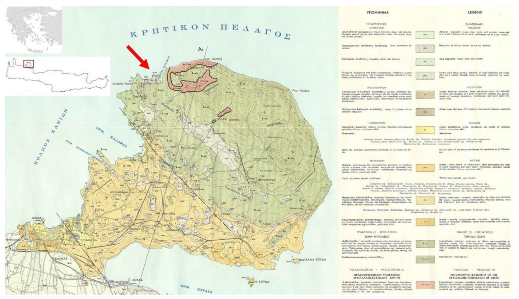
Figure 2.
Part of the basic geological map of Greece at a scale of 1:50,000, sheet Chania [12]accompanied by the map’s legend. The red arrow indicates the exact location of the study area.
Figure 2.
Part of the basic geological map of Greece at a scale of 1:50,000, sheet Chania [12]accompanied by the map’s legend. The red arrow indicates the exact location of the study area.
As noted by Zamani & Maroukian [14] „Remnants of reddish-brown and yellow calcareous sandstones, believed to be beachrock, overlie aeolianites and are observed along the western coast from Stavros to Chania.” (Figure 3). The aeolianites and beachrocks mentioned above belong to the same formation and contain shell fragments. This formation occurs in two depositional environments: The first is directly linked to the land-sea interface, where beachrock comprises coarse to very coarse sand with abundant whole shell remains. The relative age of these deposits cannot be determined by fossil fauna, as the same species still inhabit the area. This part of the formation is poorly sorted, slopes seaward, and is currently observed up to 5 m above sea level. The second part overlies the beachrock and extends up to 18 m in elevation. Locally, it covers red soils and limestones. The aeolianite (known in Greece as “poros - πόρος» or „porolithos - πωρόλιθος”) exhibits: a) coarse to medium calcareous sand, b) crossbedding with near-horizontal to steeply inclined laminations, including abundant mollusk shell fragments and c) extensive distribution around dune-like structures in the Stavros area, overlying Mesozoic age formations. Chronologically, the beachrock likely formed during a lower sea-level phase at the onset of the last glacial period (Tyrrhenian III). Aeolianite deposition in the area along Akrotiri’s western coast is attributed to the cold, arid conditions and prevailing northwestern winds of this period[14].
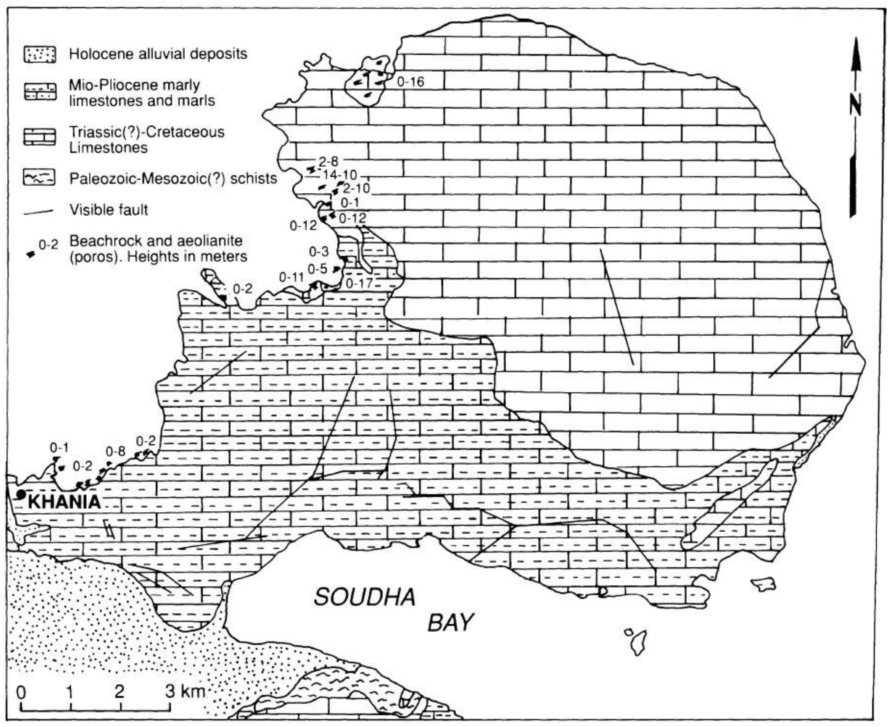
Figure 3.
Generalized geological map of Akrotiri peninsula with the spatial distribution of beachrock and aeolianite sites along the west coast[14].
Figure 3.
Generalized geological map of Akrotiri peninsula with the spatial distribution of beachrock and aeolianite sites along the west coast[14].
While Zamani and Maroukian [14] suggest both beachrocks and aeolianites formed during the early last glacial period, Fytrolakis [15] indicates a sequential formation. Beachrocks formed gradually during sea level retreat, with aeolianites developing later when the retreat reached maximum recession. Supporting evidence includes the 2–4-meter thick aeolianite deposits overlying beachrocks, with significant portions currently below sea level or subject to wave action.
The tectonic history of the region is complex and has significantly influenced the current morphology of the peninsula. The morphotectonic evolution of Akrotiri has been significantly influenced by the regional tectonics of the southern Aegean. From the Oligocene to the Middle Miocene, Crete was part of a much larger landmass in the present-day southern Aegean. Beginning in the Middle Miocene, Crete experienced tectonic subsidence, leading to shallow marine and brackish water sedimentation, followed by open marine deposition until the Late Pliocene. In the Akrotiri area, this period saw the deposition of marls and marly limestones and the formation of a marine planation surface south of the present northern massif. A short hiatus occurred at the end of the Miocene during the Messinian „salinity crisis” of the Mediterranean when gypsiferous deposits were laid down. Such deposits are locally observed in the marly limestones of the peninsula. From the Late Pliocene through the Middle Pleistocene, renewed faulting and emergence of several fault blocks due to differential vertical movements gave Crete its present configuration. The formation of Souda Bay occurred during this period. The marine terrace and the Mio-Pliocene deposits were uplifted and tilted to the northwest and northeast. The steepness of slopes along the northeastern and eastern coasts suggests that faulting remained active until at least the Middle Pleistocene. By the end of the Middle Pleistocene, the break-up of the marine terrace had occurred, forming the steep escarpments of eastern Akrotiri. This tectonically active period was followed by a phase of relative stability. A break in slope between the 80 to 100 m contours in the west suggests a prolonged sea level stand after the Middle Pleistocene, probably during the Günz-Mindel interglacial. More recent geological features include notches and benches formed at various elevations (40-60 m, 16-20 m, and 5-7 m) along the western coasts, indicating different sea level stands during the Late Pleistocene. The formation of shallow, low dolines is placed during the Tyrrhenian II of the last interglacial, while beachrock deposits likely formed during a lower sea level stand at the beginning of the last glacial epoch (Tyrrhenian III) [13,14].
The most notable recent event was the uplift along the coasts of Western Crete during the 365 CE earthquake [16]. Historical records indicate that from approximately 4200 years BP until the fourth century AD, this area experienced gradual tectonic submergence followed by a sudden uplift of 1.5 to 2 m. The notches and benches formed during this short period are observed throughout all the western and parts of northern and southern Akrotiri. Although the seabed of the Akrotiri area likely emerged by 0-2 m during this event, it remains partly submerged due to a subsequent sea-level rise exceeding 1 m [17].
The drainage networks of Akrotiri are characterized by intermittent flow and morphologically very young valleys. There is only one spring of very low discharge in the east between the Mesozoic limestones and Neogene marly limestones. The hydrological network formed discharges the surface water into the sea with an ephemeral river Nerokampos (Watercampos), located to the east of the study area (Figure 1).
3. The Stavros Quarry at Akrotiri
In Stavros Bay, aeolianites form a distinctive protrusion that divides the bay into two smaller ones. In this wider area of Stavros Bay, a quarry region is documented in the Corpus of Ancient Quarries of Greece with two locations: „417. Location: Stavros, Tigani” and „418. Location: Stavros, Trachili” [5]. This partially submerged coastal quarry extends over approximately 6 hectares and represents one of the most significant examples of aeolianite extraction on the island. Aeolianites are widely distributed along the coastal front, displaying distinctive crossbedding and representing the primary extraction material from the quarry. These biogenic wind-deposited calcareous sandstones are composed mainly of marine fossils including foraminifera, lamellibranches, echinoid spines, and small shells of the dwarf sea urchin Echinozyamus pusillus, as well as fragments of calcareous algae [18]. The cross-bedded structures in the aeolianites are not equally apparent in all locations along the coastal front. However, they exist intraformationally, and this slight differentiation should be systematically examined through measurements of stratification surfaces in the fossilized dunes (Figure 4 a-b). The aeolianites overlie beachrock and extend to an elevation of 16 m. They locally cover the red soil and, in places, the limestones. Over time there have been significant sea level changes affecting the quarry. Ιn the southwest of Stavros Bay, the land has risen by approximately 1 meter. Conversely, a large portion of the eastern quarry’s base is typically covered with shallow water. A tidal notch at 0.50-0.60m height inside the quarry serves as evidence of this submersion, corresponding to organic remains of Vermetus arenaria reaching up to 0.6m above water level [18].
The eastern quarry shows evidence of systematic extraction progressing from inland toward the sea. A protective wall approximately 1 meter high was left facing the sea, from which up to three layers have been removed. In total, four layers have been extracted, with evidence of four additional layers being removed in the western section of the eastern quarry to continue extraction in that direction. The western quarry covers a significantly larger area than the eastern one. The aeolianite forms a dam-like front toward the sea. In the northeastern part, only two layers have been extracted, while in the western section, the number of extraction steps increases to three, and in the western coast area, up to five layers have been removed. Evidence of different extraction techniques is preserved in various parts of the quarry. The working face preparation was done using a) oblique strikes, and b) herringbone pattern strikes. Quarrying channels still visible in some areas of the quarry floor were opened with a tool having a straight edge approximately 0.02m wide. In other areas, there is evidence of sewage and small, dense oblique strikes for smoothing the working faces. The total thickness of the aeolianite rock excavated in both parts of the quarry is more than 16 m thick. This information can be extracted from measurements and comparisons at various locations within the quarry, but mainly from the almost square carved „witnesses” (Figure 4a-b).
In the eastern quarry, a square „witness pillar” was left uncut to serve as a reference point, similar to the obelisk found in the Clot del Mèdol quarry in Catalonia, which Figure 2. This is a figure. Schemes follow the same formatting are definitively Roman in origin. The height of the stone blocks removed from the Stavros quarry is approximately 0.40-0.50m [3]. Similar „witness pillars” are found in the western quarry. An intriguing question raised by these dual monuments of nature and extraction technology is whether the „witness blocks” were only calculation positions or are also monuments of respect for the fossilized roots that were revealed during quarrying. ‘Witnesses’ were defined as remnants of the mining process that remained intact. If one examines the ‘witnesses’ in detail, one will notice that in all of them there are remains of rhizoliths, i.e. fossilized roots, but also of trunks. Starting from the question of why the area with the many obvious rhizoliths was not mined (because aeolian material with an increased presence of paleo-soils was mined nearby), we are led to the question raised by these double monuments of nature and historical mining technology: Were the „witnesses” simply sites of calculation, or were they also historical natural monuments, monuments of respect to the fossilized roots and trunks revealed during the quarrying of the aeolianites.
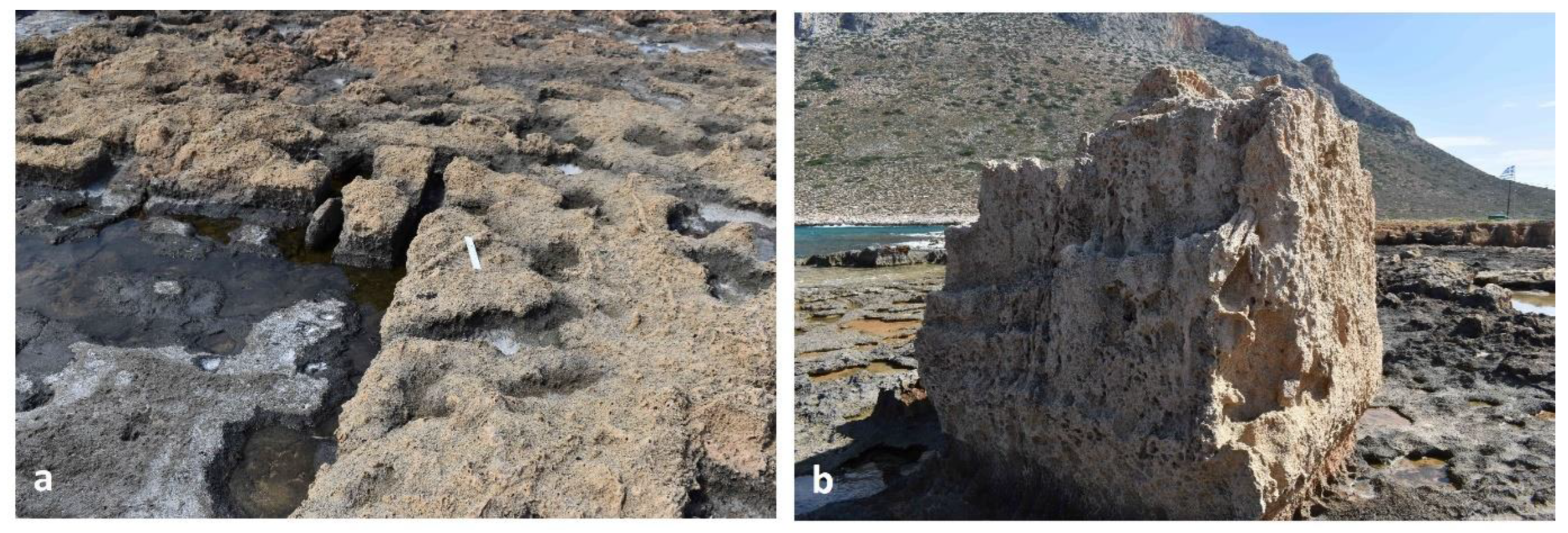
Figure 4.
(a) The figure depicts a partially submerged coastal aeolianite quarry at Stavros, in the area known as „Trachili”. The surface is relatively flat, with clear extraction grooves visible. The area has undergone subsidence, evidenced by the presence of shallow water filling some of the quarry’s depressions. The white ruler 25 cm long used as a scale indicator, emphasizing the scale and dimensions of the extraction grooves and the general morphology of the quarry floor; (b) A prominent „witness” block (unquarried square pillar) of aeolianite is depicted here. This pillar was intentionally left unquarried, serving as a reference point or marker („witness”) indicating the original height and thickness of the quarried layers, which is approximately 2 meters. At its base, a distinct tidal notch caused by wave erosion is visible, indicating previous higher sea levels and marine erosion activity. The surrounding landscape includes eroded surfaces and partially submerged sections, emphasizing both the historical quarrying processes and the natural erosional forces that have shaped the site. In all places there are visible remains of rhizoliths.
The quarry’s exploitation dates to the Minoan period and intensified during the Medieval period by the Venetians [3]. Venetian archives document the extraction of building materials from Stavros quarry, particularly during the later period when the walls of Chania were expanded and reinforced [19]. Moody [19]does not exclude the possibility that this quarry was used as early as the Bronze Age. The small height of some extraction steps could suggest medieval quarrying activity, as cuboid stones of that period typically had lower heights. On the floor of the Stavros quarry, the aeolianite debris created from the quarrying works has been cemented together with fragments of clay vessels. This diagenesis barely differs, if at all, from the diagenesis of the aeolianite. This is due to the influence of seawater that floods the quarry floor (Figure 4a) during waves, carrying foraminifera shells with it.
Modern exploitation of the quarry is evidenced by blast marks and electric wheel traces in the western quarry. Unfortunately, parts of this valuable archaeological site are at risk of encroachment by unauthorized housing developments. The site gained international recognition as a filming location for Michael Cacoyannis’s iconic 1964 film „Zorba the Greek”.
3.1. Mineral Composition of the Aeolianites and Beach Sands
As mentioned above, the name that has prevailed not only for the beach but for the whole area and which comes from the name of the local community is Stavros Bay and is used in various scientific publications. Within this area, Trachili Bay is a small pocket beach located west of the alpine formation, is only 0.2 km long and hosts a sandy coast (Figure 1). The beach sediments at Trachili Bay consist mainly of medium and coarse sand, with grain size measurements showing moderately well or well-sorted samples that are symmetrical or slightly negatively skewed, and mesokurtic or leptokurtic in distribution. The mineral composition at Trachili Beach reveals an exceptionally high carbonate content (90%), making it one of the beaches with the highest carbonate proportion among the 22 studied beaches in Crete. Low-Mg calcite is the dominant mineral in these sediments. This high carbonate content is consistent with the beach’s location in a nearly pure limestone area, where coastal formations serve as the primary sediment source. The area experiences summer winds called Etesians or Meltemi, which are mainly from the NW direction. These winds are typically light to moderate and remarkably steady in direction. Winter winds are more variable but generally from NW with a secondary W mode. The predominant waves reach Stavros and Trachili Bay from the NNE direction, affecting sediment transport patterns. Interestingly, Trachili Beach exhibits an unusual pattern where non-carbonate grains show better roundness than carbonate grains, contrary to the pattern observed at most other beaches of Crete the results of which are presented in the same study. There is also a river discharging onto the beach, which contributes to the sediment composition and transport dynamics. The beach features dunes in its backshore area, with a width ranging from 8-20 m and a moderate beach face slope of 4-13° [20].
In addition to the analyses on sands from Trachili beach, grain size and chemical analyses have been carried out on a total of 14 samples of aeolianites from Stavros Bay. According to the results of this study, the proximity to the coast facilitates the transfer of new material from beach sand, particularly foraminifera shells. Both beach sand and aeolian deposits consist predominantly of these shells. Aragonite similarly shows a decreasing trend from coast to interior, with sample 5 being an exception. This anomaly may result from enrichment with light fragments of organic materials, as sample 5 originates from the most remote aeolian deposits and has the finest grain size. The total carbonate content (including clastic, organic, and cement components) reaches 97%. Quartz predominates in insoluble material, with illite and kaolinite also present. Magnesium calcite appears in noticeable quantities, and these aeolianites exhibit excellent diagenesis [15].
4. Rhizoliths
Rhizoliths are diverse organosedimentary structures formed and resulting from complex biogeochemical interactions between plant roots, microorganisms, and surrounding sediments, exhibiting distinctive morphologies classified into several principal types based on their detailed characteristics and typically preserved through mineralization processes such as calcification, silicification, or gypsum precipitation [21,22,23].
Their formation involves root physiological activities, including transpiration and respiration, producing elevated concentrations of CO₂ and organic acids, leading to the localized dissolution and re-precipitation of carbonate minerals [24,25,26]. Soil moisture and evapotranspiration play critical roles in rhizolith genesis, influencing the precipitation of secondary minerals by controlling mineral saturation states and ionic availability in the rhizosphere [26,27,28]. The resulting structures typically exhibit distinct concentric zoning composed primarily of micrite and sparite, indicative of repeated cycles of mineral precipitation and dissolution under fluctuating environmental conditions [29,30,31]. Preservation of rhizoliths is highly dependent on post-depositional conditions; intact, in-situ rhizoliths are rare, typically found preserved within subsurface horizons, protected from extensive surface weathering and erosion, whereas those exposed at the surface often undergo fragmentation and chemical alteration, complicating paleoenvironmental interpretations [26,32]. Diagnostic criteria for distinguishing rhizoliths from animal burrows involve detailed analyses of morphology, branching patterns, internal structures, and mineralogical composition [32,33,34]. Rhizoliths typically exhibit tapering branching patterns with progressively decreasing diameters away from main vertical axes, indicative of their botanical origin, whereas animal burrows often maintain relatively constant diameters along their lengths and branches [31,35]. Additionally, rhizoliths frequently show internal concentric zonation due to successive mineralization events related to root metabolic activity, microbial influence, and fluctuations in soil moisture and geochemical conditions, a feature rarely seen in animal burrows [26,36]. Microscopic characteristics such as calcified root hairs, fungal hyphae, cellular-level preservation of original root tissues (e.g., cell walls, epidermal layers), and micritic structures further support their biogenic origin, distinguishing rhizoliths clearly from faunal burrows, which typically lack these fine-scale biological features [37,38].
4.1. Rhizoliths Morphology and Classification
The classification and morphological typology of rhizoliths has evolved significantly since Klappa’s [21] original framework, which established five primary categories: root moulds (tubular voids left after root decay), root casts (sediment-filled moulds), root tubules (cemented cylinders around moulds), rhizocretions (mineral accumulations around roots), and root petrifactions (mineral replacement preserving anatomical features). This foundational classification has been expanded through detailed micromorphological and petrographic investigations revealing internal structures such as concentric micritic and sparitic zoning, microbial filaments, and calcified root hairs frequently preserved in rhizocretions and tubules [32]. Additional specialized morphotypes include compound rhizoliths, which form through superposition of multiple growth and mineralization phases within the same root trace, often displaying cross-cutting relationships, overprinted fabrics, and complex diagenetic zonation [34]. Rhizohaloes represent another distinct type, characterized by subtle discoloration zones around roots caused by geochemical diffusion during active root respiration and decay, commonly occurring in association with more solid rhizolith forms [32]. Integrated classification frameworks now distinguish between primary in-situ rhizoliths, which retain original growth position and relationship to soil horizons, and secondary rhizoliths, which have been reworked, compacted, or chemically altered beyond their initial pedogenic context [26,32,39]. The recognition of micro-rhizoliths, including mineralized root hairs and cellular structures, has further expanded the classification into microscale features, requiring thin section petrography and scanning electron microscopy for identification [37,40]. Based on mineral composition, rhizoliths may be categorized as calcitic (most common), siliceous, gypsiferous, or containing iron-manganese oxides, each reflecting distinct biogeochemical conditions during formation. Mn-bearing rhizocretions, identified in the Willwood Formation of Wyoming, exemplify the importance of redox-sensitive trace elements in rhizolith development [41], while gypsum rhizoliths found in the Algerian Sahara form under hyperarid conditions with sulfate-rich soils [22]. Morphologically, rhizoliths may be classified according to their branching patterns, with vertical, horizontal, and dendritic forms recognized in various sedimentary contexts. Megarhizoliths or rhizocretion networks are particularly prominent in aeolianite deposits of coastal environments such as the Canary Islands, Crete, and Gran Canaria, often emerging in erosional relief due to differential cementation [6,42]. Finaly some rhizoliths, locally exhibit bulbous swellings which were identified as rhizobial root nodules [43]. The classification system also considers the degree of anatomical preservation, with some exceptionally preserved specimens retaining cellular-level details of vascular tissues, epidermal cells, and root hairs, particularly in silicified examples from geothermal environments [21,44]. The combination of field observations—such as orientation, branching pattern, and stratigraphic position—with laboratory analyses, including thin section petrography, SEM imaging, cathodoluminescence, stable isotope geochemistry, and trace element profiling, allows for precise differentiation between rhizolith types and related biogenic structures [45].
4.2. Related Work: Global Distribution of Rhizoliths Studies
Rhizoliths have been comprehensively investigated across diverse continental regions and throughout numerous geological epochs. The present synthesis documents the global distribution of rhizolith investigations, elucidating the varied geological chronologies and depositional regimes in which these significant paleoenvironmental proxies occur. The Iberian Peninsula constitutes a notable locus of rhizolith research. Klappa [21] conducted examinations of specimens obtained from littoral zones of continental Spain and the Balearic archipelago (Ibiza and Mallorca), with particular emphasis on terrestrial carbonate formations, specifically calcretes and aeolianites of Quaternary chronology. McLaren [28] analyzed aeolianites and elevated beach sediments dating to the Late Pleistocene from southern mainland Spain and Mallorca in a comparable investigation. Esperante et al. [31] undertook investigations of rhizolith-containing strata within the Cariatiz Formation in the Sorbas Basin, Almería Province (southeastern Spain). Within the Canary archipelago, Alonso-Zarza et al. [46] catalogued Pleistocene megarhizoliths occurring in the dune complex of Tufia on Gran Canaria. Germanic territories have produced significant rhizolithic investigations, particularly within loessic depositional contexts. Gocke et al.[24] procured rhizolith and loess specimens from a Late Pleistocene loess-palaeosol stratigraphic succession at Nussloch in southwestern Germany. Italy has Pleistocene rhizoliths, as noted by Nascimento et al. (2019). Denmark contains numerous caliche nodules with rhizoliths in the Upper Triassic Kegeröd Formation on Bornholm (Knaust, 2015). France has been the site of several rhizolith investigations. Jaillard et al. [47] collected calcified roots from multiple locations in southern France, particularly in Languedoc near Montpellier and the southern Alps near Barcelonnette. In a more extensive analysis, Becze-Deák et al. [48] incorporated Germanic localities (Wallertheim) within their comprehensive examination of Quaternar loess paleosol sites distributed throughout the European loess belt, thereby contextualizing the regional significance of these pedogenic features. Other European countries with documented rhizolith studies include Austria (Stratzing), the Czech Republic (Dolni Vestonice), and Romania (Mitoc) as part of Becze-Deák et al.’s [48] research on Quaternary loess paleosols. Kozłowska [49]studied rhizoliths within paleosols in the Old Red succession of Podolia, Ukraine. Greece has rhizoliths in cylindrical and cone-shaped tube structures within Quaternary and Neogene coastal arenitic limestones near Neapolis as well as the rhizoliths described briefly within aeolianites at the ancient quarry of Stavros Akrotiri Chania Greece [6,50]. Horizontal rhizoliths have been documented within laminated oolitic aeolianite deposits near Istanbul, Turkey [51]. In a separate study, Eren et al. [52] examined Quaternary calcretes prevalent in the Mersin and Adana regions, providing a comprehensive review of previous research on Turkish calcretes.
Russia has yielded rhizoliths from various geological periods. Golubtsova et al. [38] investigated carbonate rhizoliths formed in Early Holocene dune sands in the Belaya River valley in the Upper Angara Region, Russia. Karasev et al. [39] described fossil roots of two morphotypes from Upper Permian deposits near Vyazniki in the Vladimir region. Shumilov and Tel’nova [35] studied paleosol horizons with numerous in situ roots in Devonian deposits in the Middle Timan Ridge. Alekseeva [53] collected in situ rhizoliths from Devonian and Early Carboniferous paleosols in the southern part of the Russian Platform. China has been extensively studied for rhizoliths, particularly in desert environments. Sun et al. [54] studied rhizoliths found in the late Quaternary paleolake Zhuyezhe beds in the Minqin Basin, central Tengeri Desert. Sun et al. [55] analyzed field characteristics of dune rhizoliths in the Badain Jaran Desert to investigate formation mechanisms and paleoenvironmental significance. Li et al. [56] documented rhizoliths in the Shihhotse Formation in the Xingcheng area in the northern part of the North China Plate. India has rhizoliths in various settings. Hendry [57] presented findings on silica and calcium carbonate replacement of plant roots in Quaternary coastal sediments of southeastern India. Purnachandra Rao and Thamban [58] described calcareous deposits on the western continental shelf of Bhatkal at 50 to 58 m water depths. Iran has rhizoliths in one of the most complete Quaternary successions in the country, located in the central Iran structural zone in Semnan province [42].
Kenya has been an important location for rhizolith studies. Cohen [59] examined fossil roots and root casts from obtained from the Pleistocene Upper Member of the Koobi Fora Formation deposited within the East Turkana Embayment of the Lake Turkana Basin. Owen et al. [44] documented a wide range of rhizoliths around the margins of Lake Bogoria, Kenya Rift Valley, composed of various minerals, including opaline silica, calcite, zeolites, fluorite, and possibly fluorapatite. Egypt has yielded rhizoliths from several geological periods. Matteucci et al. studied the environmental changes during the late Holocene in the coastal southern [60] Somalia inferred from the Achatina and rhizolites Bown [61] studied ichnofossils and rhizoliths of the Oligocene Jebel Qatrani Formation in the northern part of the Fayum Depression in Egypt. At the same site Badawy [62] studied the preserved termite nest and galleries structures and rhizoliths indicating tropical to subtropical forest environments. Abdel-Fattaha and Gingras [63] recognized three types of rhizoliths in the upper middle Eocene in Eocene strata of Wadi El-Hitan universal heritage area, Fayum, Egypt. South Africa has been the site of rhizolith studies, with Cramer and Hawkins [64] collecting root casts and Morella cordifolia from Vergaderingskop near Still Bay in the Western Cape. Algeria has rhizoliths in carbonate shells found in gypsum and limestone formations of medium Quaternary age in the Ziban oases at the piedmont of the Boughzel Mounts in the Algerian Sahara [22]. Tanzania has yielded important rhizolith studies. Habermann et al. [65] discovered fossil rooted tree stumps in Lower Bed I from the western Olduvai Basin, providing direct evidence of living trees at Olduvai Gorge from approximately 2.038 to 1.88 Ma. Morocco has Paleozoic deposits with ichnofossils, including rhizoliths, in the Jebilets of Marrakech, specifically in the hills of Koudiat Sidi Boumediane and Koudiat Oulad Abid of upper Visean age [66]. Tunisia has Tyrrhenian eolianites with root traces indicating semi-permanent vegetation during coastal eolian deposition [67].
The United States has numerous rhizolith studies across various states. Wang [68] found rhizoliths in Peoria Loess in Illinois. Liutkus [69] documented calcitic plant stem molds on the playa surface at Pilot Valley in eastern Nevada. Woody et al. [41] described siltstone and sandstone columns preserved in Wyoming’s paleosols of the Willwood Formation. Hembree and Hasiotis [70] studied ichnofossil-rich paleosols in Colorado’s upper Eocene to middle Oligocene White River Formation. Gregory et al. [71] investigated Quaternary coastal-terrestrial deposits from Sapelo Island, Georgia. Hembree and Nadon [72] examined ichnofossil-bearing paleosols in the Conemaugh Group of southeastern Ohio. The Bahamas has been studied for rhizoliths in several locations. McLaren [36] and [73] included North Andros, San Salvador and New Providencer Island in studies of Late Pleistocene aeolianites, raised beach deposits and root-related calcretes from the Bahamas. Curran [74] documented trace fossils, including rhizoliths on Upper Pleistocene caliche surfaces on San Salvador Island. Jones and Booker [45] described well-preserved rhizoliths up to 12 cm in diameter in the Pleistocene Ironshore Formation on the Cayman Islands. Canada has documented root traces in the Fort Prével Member of the Battery Point Formation (late Early Devonian, Emsian) in Gaspé Bay, Québec [75]. Brazil has rhizoliths in paleosols of the Marília Formation of Maastrichtian age (Cretaceous) in the western portion of Minas Gerais, southeastern Brazil [33,34]. Argentina has been studied for rhizoliths in various geological contexts. Bedatou et al. [76] surveyed localities in Santa Cruz Province belonging to the Deseado Massif with Jurassic-Cretaceous continental volcaniclastic sedimentation. Genise et al. [77] studied the Chubut Group in Estancia El Dinosaurio, about 250 km west of Trelew city in Chubut Province, where Cretaceous rocks overlay Jurassic volcanic rocks.
New Zealand has yielded rhizolith studies from various settings. Jones et al. [23] documented siliceous rhizoliths and rhizocretions in diatomaceous sediments at Loop Road hot springs on the North Island. Gregory et al. [71] investigated Quaternary coastal-terrestrial deposits from the Aupouri and Karikari Peninsulas on the North Island. Australia has remarkable pinnacle karst in the southwestern coastal part of Western Australia, with pinnacles up to 5 m high in the Pleistocene Tamala Limestone [78,79,80].
The chronostratigraphic distribution of documented rhizolithic structures spans an extensive temporal range across the Phanerozoic. Within the Paleozoic, significant occurrences include Devonian specimens from the Middle Timan Ridge in Russia [35] and the Battery Point Formation in Gaspé Bay, Québec, Canada [75]; Carboniferous examples from the southern Russian Platform [53] and the Shihhotse Formation in China [56]; and Permian specimens from the Vyazniki deposits in Vladimir region, Russia [39] and the Abo Formation of New Mexico [81]. Mesozoic occurrences encompass Triassic specimens from the Kegeröd Formation in Bornholm, Denmark [82]; Jurassic-Cretaceous examples from the Deseado Massif in Santa Cruz Province, Argentina [76] and Cretaceous specimens from the Marília Formation in Minas Gerais, Brazil[33] and the Chubut Group in Chubut Province, Argentina [77]. The Cenozoic epoch is represented by Eocene specimens from Wadi El-Hitan, Egypt [63] and the White River Formation in Colorado, USA [70]; Oligocene examples from the Jebel Qatrani Formation in the Fayum Depression, Egypt [61,62] and the White River Formation in Colorado, USA [70]; Miocene specimens from Spain [29,83]; and extensive Pliocene-Pleistocene and Quaternary occurrences distributed across multiple continental regions [21,24,36,45,54] and numerous others. Rhizoliths have been studied in numerous works focusing on trace fossils in various formations, as well as indirectly in studies with different objectives. For instance, in Abdel-Fattah’s research [84] examining the morpho-sedimentary characteristics and generated primary sedimentary structures on the modern microtidal sandy coast of eastern Nile Delta, Egypt, as well as in Golab et al.’s [85] investigating bioturbation-influenced fluid pathways within a carbonate platform system in the Lower Cretaceous (Aptian–Albian) Glen Rose Limestone, Central Texas Platform.
The depositional regimes in which rhizolithic structures have been documented exhibit considerable diversity. Littoral environments, including aeolianites, beach deposits, and coastal dunes, are represented in Spain [21,36] the Bahamian archipelago [36,73,74], Tunisia [67], Greece [6,50] Turkey [51]and New Zealand [71]. Arid environmental settings, encompassing dune complexes and paleolacustrine systems, are documented in northwestern China [54,55], Egypt [63], Morocco [66], Algeria [22]. Fluvial depositional systems, including floodplains and alluvial accumulations, are represented in Egypt [61,62] and various localities within the United States [41,70,72], and Denmark [82]. Paleosols or ancient pedogenic profiles are extensively documented in Russia [34,35], Brazil [33]), the United States [70,72], and numerous additional localities. Lacustrine depositional contexts, including lake margins and playa accumulations, are represented in Kenya [44,59], and China [27,54]. Marine-influenced environments, such as shallow marine shelf settings, are documented in India [58].
This comprehensive global synthesis demonstrates that rhizoliths represent ubiquitous geological phenomena that exhibit remarkable preservation across diverse continental regions, extensive geological chronologies, and varied depositional regimes. Consequently, these structures constitute invaluable proxies for paleoenvironmental reconstruction and interpretation, providing significant insights into ancient ecological conditions, hydrological regimes, and pedogenic processes throughout Earth’s history
4.3. Rhizoliths Within Carbonate Aeolianites
Rhizoliths within carbonate aeolianites [86,87] commonly occur as distinctive organosedimentary structures resulting from the interplay between root systems and highly porous, carbonate-rich dune substrates under varying pedogenic and ecological conditions [36,55]. The formation of rhizoliths in these settings primarily involves plant-driven evapotranspiration, microbial activity, and capillary-driven precipitation of calcium carbonate from vadose-zone water, all contributing to local fluctuations in chemical equilibrium [26,64]. The most common rhizolith types include root tubules, which are typically vertically oriented cylindrical structures with micritic or sparitic carbonate linings that formed around decaying or living roots, often preserving original root diameter and texture [21,23,49]. In dune systems of China, India, and the Mediterranean, these tubules typically form under semi-arid to arid regimes, where plant roots act as nucleation points for carbonate precipitation [6,27,58]. Rhizocretions appear as irregular to nodular carbonate masses surrounding the former root axis, frequently exhibiting concentric internal zonation that indicates episodic mineral accretion due to fluctuating soil moisture and microbial activity. This concentric zonation reflects successive phases of calcification influenced by cyclical variations in moisture availability, evapotranspiration intensity, and microbial decomposition processes [24,63]. Root casts, which form when the root cavity is infilled by sediment or carbonate, are also prevalent and may occur as hollow or solid forms that replicate the external morphology of the root, often embedded within calcrete nodules or indurated paleosol horizons developed in stabilized dunes [33]. Microscopic and petrographic analyses consistently reveal characteristic features, including calcified root hairs, fungal hyphae, microbial filaments, and micritic carbonate cementation surrounding sediment grains, confirming their biological origin [29]. Megarhizoliths, defined by their large diameters (typically exceeding 10 cm) and complex branching morphologies, represent fossilized remains of robust root systems of shrubs or trees in well-developed paleosols [5,63]. In coastal environments such as the Canary Islands, Crete, and Gran Canaria, these megarhizoliths or rhizocretion networks often emerge in erosional relief due to differential cementation and long-term exposure, serving as key indicators of vegetation density, soil stability, and climatic phases during dune stabilization [6,31,46]. Rhizoliths formed in aeolian dune systems often exhibit shallow lateral distribution with low-angle branching and sparse vertical development due to moisture limitation and shallow rooting, as observed in studies from the Badain Jaran and Tengeri Deserts in China, as well as coastal dunes in India and Spain [31,55,58]. The presence of siliceous rhizoliths within aeolian settings is rare but has been reported in association with volcanic dune systems or post-depositional silicification, preserving cellular structures due to rapid mineral replacement [51]. Preservation of rhizoliths is commonly associated with semi-closed, redox-variable environments within sandy substrates at specific depths, conditions favorable to rapid mineral precipitation and long-term preservation [22,23,65]. The type and extent of diagenesis also contribute to rhizolith diversification in aeolianites, with early vadose cementation favoring micritic preservation and late-stage phreatic cementation producing coarser sparry fabrics, often obliterating primary biological structures, a pattern observed in aeolianites from the Bahamas and Gran Canaria [36,46].
In all cases, rhizolith morphology in aeolianites is strongly influenced by substrate composition, climatic regime, vegetation type, and groundwater dynamics, with carbonate-rich environments favoring micritic coatings and sparitic infillings. These organosedimentary features within aeolian sediments thus serve as valuable proxies for paleoenvironmental interpretations, highlighting past biogeochemical interactions, ecological dynamics, soil moisture conditions, and sedimentary processes characteristic of desert landscapes [26,36,38,55,58].
5. Methodology and Restrictions
The study area in Stavros Βαυ, Akrotiri, belongs to a protected archaeological site. Therefore, field work can be conducted after obtaining permission, but in situ samples cannot be taken. The samples that can be collected for scientific research are fragments of rhizoliths that break off due to sea erosion, primarily during the winter and spring seasons. Beyond the fact that these samples require significant time to locate, they are naturally limited in both size and number. During the fieldwork, the photographs in the field were taken with a digital camera (Nikon D 3500). Τhe thin sections were made by the staff of the „Lithos” laboratory of the Hellenic Geological and Mineral Exploration Authority. Detailed observations of the microstructure of the rhizoliths were made with a Zeiss Stemi 2000-C stereoscope. The intralux® 5100 cold light source from a Harvard Apparatus was used as a light source. This device has been specially developed for the illumination of Stereo Microscopes. Mineralogic studies were made using 12 specimens, representing 6 rhizoliths. Optical photomicrographs were made using a Zeiss petrographic microscope equipped (Zeiss Axioskop 40, Pol Research Polarized Light Microscope) with a 5-megapixel digital camera (Unibrain Fire-i™ 400 industrial camera).
6. Findings
The coastal site of Stavros Akrotiriou in western Crete hosts a uniquely significant geoheritage monument, recently recognized after a brief presentation [6] as the “Petrified Forest of Chania.” Situated within and around a historic Venetian quarry, the area contains an exceptional concentration of rhizoliths, preserved in aeolianite dunes formed according to Zamani and Maroukian [14] during Quaternary glacial periods. These rhizoliths, ranging from small trace-like forms to massive, branched structures exceeding one meter in length, display outstanding preservation and diversity. In addition to rhizoliths, in-situ petrified trunks, calcrete formations, and biokarstic dissolution features further enrich the site’s scientific value.
6.1. Paleosols, Beachrock, Aeolianites and Calcretes
In the broader Stavros region of Cape Akrotiri, the geological framework is primarily composed of Alpine basement rocks belonging to the Trypali Unit [10]. These rocks consist of semi-metamorphosed, fractured, and highly fragmented carbonates, predominantly limestones and dolomites. The Trypali Unit is extensively exposed along the eastern sector of Stavros and notably reappears further westward along Pachia Ammos beach, particularly west of the Tigani locality. The carbonate rocks exhibit extensive fracturing due to tectonic activities linked to the complex geodynamic history of Crete, shaped predominantly by the Hellenic arc’s subduction and associated compressional tectonics [88]. These tectonic processes facilitated significant weathering and erosion, contributing to the formation of soil horizons upon these carbonate substrates. Directly overlaying these carbonates, thin layers of terra rossa soil developed. Although it is generally assumed that parts of the present land cover in Crete are the shallow remnants of formerly complete soil profiles that have been degraded by anthropogenic land use over the last millennia [89], recent studies help to understand the Terra Rossa soils in western Crete [90,91]. Terra rossa is typical Mediterranean soil characterized by an association of the Mediterranean climate, high internal drainage (due to the karstic nature of the underlying hard limestone) and neutral pH conditions. As residual soil type is rich in iron oxides, which imparts a characteristic reddish coloration [92]. Unlike typical Mediterranean reddish-brown soils formed through clay illuviation, soil-sediment profiles on Cretan slopes show remarkably weak Holocene pedogenesis. Analysis of various profiles reveals that discontinuities result primarily from geomorphological processes rather than in-situ pedological development. The main pedogenic process observed is bioturbation, alongside surprisingly high organic carbon content. A key finding is the significant influence of Saharan dust inputs, identified through characteristic peaks in clay and silt grain size distributions. These inputs create unexpectedly homogeneous geochemical conditions across otherwise diverse landscapes [93]. In Stavros, the terra rossa is typically thin, rarely exceeding 0,5 meters thick, reflecting relatively limited durations of subaerial exposure and pedogenic processes in these particular stratigraphic intervals. Pedogenic diagenesis subsequently transformed these thin terra rossa layers into consolidated paleosol horizons. These horizons act as clear indicators of distinct paleoenvironmental episodes, characterized by periods of soil stability and limited sediment input, allowing for significant soil development [94]. Above these paleosols, discontinuous accumulations of beachrock occur as thin, bedded conglomeratic deposits. These beachrock are particularly noteworthy due to their unique genetic and depositional attributes.
Formed in the intertidal zone, beachrocks are cemented coastal sediments typically composed of sand-sized and gravel-sized clastic particles bound by carbonate cement precipitated from seawater [95]. In the Stavros area, beachrocks vary substantially in their geometry, with each bed displaying distinct spatial variations in thickness, lateral extent, and inclination. These variations reflect not only the paleogeographic position of the shoreline during their formation but also the local hydrodynamic regime, including wave energy, tidal ranges, and nearshore sediment supply dynamics [96]. Specifically, the beachrocks west of the river mouth Watercampos (Figure 1) occur intercalated with terra rossa paleosols and the underlying fragmented carbonates of the Trypali Unit. Their characteristic geometry involves discrete, elongated benches several meters in length and width, with marked variations in elevation relative to the present sea level. Such vertical and lateral positional differences indicate multiple beachrocks generations associated with historical sea-level stands. Furthermore, beachrocks at the eastern part of Stavros beach developed atop sediments delivered by a significant alluvial fan system, itself intensely fractured and partially overlaying the in-situ Trypali Unit carbonates. This complex interplay between terrestrial sediment influx, tectonic fracturing, and marine cementation highlights the intricate and dynamic geological history of the Stavros region (Figure 5 a,b).
Paleosols represent a fundamental element of the Stavros Bay promontory stratigraphy, functioning as the primary substrate for rhizolith development. These fossilized soils, preserved within the geological record after formation during earlier periods, offer invaluable insights into paleoenvironmental conditions and ancient ecosystem dynamics [97]. Within the Stavros area, paleosols are prominently characterized by their distinctive reddish coloration—commonly described as terra rossa. Such coloration typically arises from the pedogenic alteration of carbonate-rich parent materials under Mediterranean climatic conditions, leading to the concentration of iron oxides and hydroxides [98]. The terra rossa soils at Stavros appear repeatedly throughout the stratigraphic sequence, usually at the basal contacts of aeolianite layers, highlighting episodic cycles of pedogenesis interspersed with phases of aeolian sedimentation. These cycles suggest alternating environmental conditions, where stable climatic phases allowed prolonged soil formation, later interrupted by active deposition periods associated with aeolian dynamics [99]. According to the classification system introduced by Birkeland [98], the paleosols at Stavros clearly fall under the category of buried paleosols—soils that were previously exposed at the earth’s surface but subsequently buried beneath younger sedimentary deposits. Their stratigraphic positioning and preservation within the aeolianites strongly indicate that after substantial pedogenesis and development of soil profiles, subsequent aeolian deposition episodes covered and effectively fossilized these terrestrial surfaces. The repetitive appearance of these buried paleosols suggests a rhythmicity in the paleoclimatic conditions, involving multiple episodes of climatic stability alternating with active aeolian sediment transport and accumulation. This cyclicity underscores complex climatic fluctuations throughout the geological history of the region, likely influenced by shifting wind patterns, sea-level changes, and regional climatic variations [99].
The horizons of these paleosols in the Stavros Bay promontory area are distinct, traceable, and well-defined throughout the site’s stratigraphy. The upper portions of these paleosol profiles frequently exhibit well-developed calcrete horizons, strongly indicative of intense pedogenic carbonate accumulation. Calcrete horizons form primarily through the vertical translocation and precipitation of calcium carbonate from percolating soil waters, facilitated by seasonal moisture variations characteristic of semi-arid climatic regimes.
Their thickness, hardness, and the degree of cementation generally reflect prolonged exposure at or near the surface, enabling significant pedogenic modification and calcification [98,99]. Some of the results of the above physical processes can also be seen in Figure 6 (a,b). In Figure 6a, the paleosol appears prominently within the aeolianite sequence and exhibits clear horizonation with well-differentiated layers. The soil profile is approximately 50-70 cm thick, measured against the scale provided by the stick (1 m). It consists of a reddish-brown horizon at the base that is suggestive of advanced pedogenesis, likely associated with oxidizing conditions and prolonged exposure. This basal horizon shows a strongly developed iron-rich layer, typical of Mediterranean terra rossa soils, characterized by iron-oxide coatings on grains and extensive carbonate dissolution features indicative of intense chemical weathering [29]. Above this distinct basal horizon, the paleosol grades upwards into lighter brownish-beige sandy materials representing reduced pedogenic alteration, reflecting weaker chemical weathering processes or shorter soil-forming intervals. The upper boundaries of this paleosol are diffused and irregular, indicative of erosional truncation or depositional hiatus before the deposition of overlying aeolian sediment [36]. In image 6b, the paleosol is exposed as a well-defined layer underlying porous aeolianite deposits. The paleosol is about 25-35 cm thick, as indicated by the 25 cm ruler for scale, and presents a reddish-brown coloration characteristic of terra rossa paleosols commonly found in Mediterranean environments, developed under warm and humid conditions [100]. The upper boundary between the paleosol and the overlying carbonate-rich aeolian sediment is sharp and irregular, indicating a clear interruption in sedimentation and pedogenesis. Within this paleosol, there are abundant features of soil development including distinct aggregates, rhizoliths, and occasional lithoclasts. The presence of abundant rhizoliths signifies active vegetation cover during paleosol formation, suggesting a vegetated land surface with significant biological activity [36,38]. The paleosol layer is densely cemented by carbonate, which indicates periodic wetting and drying cycles typical of semi-arid to sub-humid climatic conditions during soil formation [27].
Aeolianites constitute another essential lithological unit within the geological sequence of Stavros, forming significant sedimentary accumulations above beachrocks deposits or directly atop paleosol layers. These aeolianite deposits, originating from windblown carbonate-rich sands, reflect prolonged periods of arid to semi-arid conditions, along with significant aeolian activity and sediment transport [86]. The aeolianites in Stavros Bay exhibit pronounced stratification characterized by cross-bedded structures, indicative of dominant wind directions and sediment transport pathways prevailing during deposition [101].
According to Zamani and Maroukian [14], the deposition of beachrock and overlying aeolianites along the western coast from Stavros to Chania likely occurred during the beginning of the last glacial period (Tyrrhenian III). The aeolianites represent ancient coastal dunes formed during periods of lower sea levels. The cold, dry conditions of this period, combined with the action of prevailing northwestern and western winds, facilitated the formation of these deposits. The aeolianite formations consist primarily of bioclastic material, including foraminiferal remains, bivalve shell fragments, echinoid spines (including the dwarf sea urchin Echinozyamus pusillus), and calcareous algae [18]. These materials indicate the marine origin of the carbonate sand that was subsequently transported by wind to form the dune systems. The aeolianites display characteristic cross-bedding structures, particularly evident in the quarry exposures, reflecting their aeolian depositional nature. The total thickness of aeolianites at Stavros is challenging to determine precisely due to limited exposure and laterally varying depositional patterns; however, their cumulative observable thickness consistently exceeds four meters, with the greatest accumulations evident in the western sections of the area. These thicker aeolian deposits suggest spatial variations in wind intensity, sediment availability, and topographic control during their formation.
The aeolianite exposures at Stavros quarry region, Akrotiri peninsula, exhibit distinctive sedimentological and morphological characteristics indicative of wind-mediated carbonate deposition processes. The outcrops demonstrate pronounced stratification heterogeneity, with bedding orientations ranging from horizontal to inclined, accompanied by significant porosity gradients and differential cementation patterns. Figure 4a presents an aeolianite sequence characterized by well-defined stratification with predominantly carbonate composition manifested in sandy textures of beige to pale brown hues, reflecting pedogenic influence during formation. The aeolianite formation demonstrates advanced lithification and weathering phenomena with extensive dissolution-induced cavities and channels; this lithofacies presents darker grey to brown chromatographic signatures attributable to enhanced biological activity and microbial colonization. The vertical stick (1 meter) provides scale reference.
Interbedded within the aeolianites are paleosol horizons, commonly only a few ten centimeters thick, which often preserve well-formed calcretes (pedogenic carbonate horizons). Calcrete, also known as „caliche,” describes a surface or subsurface accumulation primarily of calcium carbonate (CaCO₃) in unconsolidated sediments, sedimentary rocks, and soils [102].These horizons represent former land surfaces upon which vegetation stabilized the dunes, allowing soil formation processes to develop. Calcretes occur in various morphologies: laminar crusts, nodular aggregates, and massive hardpans. Their genesis, as supported by Goudie [102] and Wright and Tucker[99] involves the vertical and/or upward migration of carbonate-rich solutions in semi-arid climates, leading to precipitation and cementation of CaCO₃ in the soil profile. In some cases, rhizogenic calcretes formed directly around root systems, contributing to the preservation of rhizoliths. These root-related calcareous accumulations are especially abundant in the red aeolianites and calcrete zones of the Stavros site, where dozens of vertical and horizontally oriented rhizoliths penetrate the paleosol-aeolianite interface. Calcrete formations represent significant carbonate accumulations within soil profiles that provide valuable paleoenvironmental information, particularly about prevailing arid to semi-arid conditions during their formation [29,99,103].
At Stavros Beach Akrotiri, extensive calcrete formations have been documented within aeolianite deposits, playing a crucial role in preserving rhizolith structures and recording the region’s paleoenvironmental history. The calcretes at Stavros Akrotiri appear in various morphological forms, including hardpan crusts (surface-hardened layers several centimeters thick, forming extensive platforms), nodular calcretes (concretionary masses within the sediment), and laminar calcretes (thin, layered carbonate deposits exhibiting distinct laminations). These formations align with Wright and Tucker’s concept [99] of rhizogenic (root-formed) calcrete, where carbonate concentration is attributed primarily to root activity. The calcification process may have occurred either intracellularly in plants or extracellularly around roots, with both processes potentially contributing to the diverse calcrete morphologies observed at the site [104,105]. At Stavros Akrotiri, calcrete crusts range in thickness from a few centimeters up to 25 cm and exhibit different colorations—those found directly above paleosols have a reddish color, while those within the gray aeolianites maintain their gray coloration. The largest occurrences of rhizoliths, preserved within these calcrete formations, are found on surfaces exceeding 50 square meters in the red calcrete crusts (Figure 8). These areas contain the largest branched rhizoliths and mega-rhizoliths, representing significant paleoenvironmental archives. The site features extensive exposures of carbonate coastal platforms with prominent calcrete horizons that display characteristic textures and structures resulting from pedogenic and diagenetic processes. Relatively flat, indurated carbonate surfaces form extensive calcrete horizons exhibiting pronounced hardpan development with distinctive irregular microrelief and surface crusting. Such features typically develop under semi-arid to arid climates through cyclic episodes of carbonate precipitation, infiltration, and subsequent cementation within soil horizons, indicating prolonged subaerial exposure and landscape stability [103]. At Stavros Bay, Akrotiri, evidence suggests that rhizogenic processes played a dominant role in calcrete formation, with plant roots facilitating carbonate precipitation through both direct and indirect mechanisms [21,104]. The presence of extensive calcrete horizons indicates periods of soil development under semi-arid conditions with seasonal moisture availability—conditions conducive to calcrete formation. The preservation of rhizoliths within these calcrete crusts provides additional evidence of past vegetation cover, allowing for reconstruction of plant communities that once inhabited this area. The varied morphologies of the calcrete formations further suggest multiple phases of development under fluctuating environmental conditions throughout the Quaternary period. The calcrete formations within aeolianites at Stavros Akrotiri offer valuable insights into the paleoenvironmental history of the region. These features record periods of landscape stability, vegetation establishment, and specific climatic conditions that prevailed during their formation. The calcrete crusts have played a critical role in preserving rhizolith structures, particularly in areas where extensive calcrete development has protected these features from erosion. Further investigations of these calcrete horizons and associated structures may provide additional details about the timing and environmental conditions of their formation.
6.2. Rhizoliths
At Stavros Akrotiriou in Crete, an exceptional abundance of rhizoliths has been identified within aeolianite formations, representing one of the most significant localities for studying ancient root systems preserved through calcification processes. Rhizoliths represent the common term for all trace fossils of plant roots formed through plant-substrate interactions [21]. When plant roots decay, they leave behind trace fossils that document these interactions and indicate the relative position of vadose or phreatic zones [32,106]. The preservation of root traces in the form of rhizoliths is commonly associated with palaeosols and induces physical and chemical changes in the host sediments[71]. The formation of rhizoliths at Stavros followed a complex sequence involving initial root growth as coastal vegetation developed on dune systems in alternation with thin soils, followed by mineral accumulation as the interaction between plant roots, soil water, and carbonate created conditions favorable for calcium carbonate precipitation within and around the root structures. This process was likely enhanced by microbial activity in the rhizosphere, the zone immediately surrounding plant roots where complex plant-microbe interactions occur. After plant death, the decomposition process may have been interrupted by rapid burial under new dune deposits, allowing for exceptional preservation of the original root structures. Two primary mechanisms explain rhizolith formation: higher water uptake than Ca²⁺ by roots, associated with high CO₂ from rhizomicrobial respiration, leading to CaCO₃ supersaturation, and release of HCO₃⁻ by roots, increasing soil pH and causing CaCO₃ precipitation [107]. This root encrustation process is considered relatively rapid, occurring over years to decades during or shortly after the plant’s life [24,30].
Klappa [21] identified five basic types of rhizoliths: root molds (tubular voids outlining the positions of former, now decomposed roots), root casts (root molds filled with sediment and/or cement), root tubules (cemented cylinders around root molds), rhizocretions (pedogenic accumulations of minerals around living or dead plant roots), and root petrifactions (replacements of the original organic matter where anatomical features have been preserved). The rhizoliths at Stavros primarily represent root casts and root petrifactions, with many exhibiting excellent preservations of external morphological features. They occur less frequently root molds. Their occurrence within the aeolianites indicates that vegetation periodically stabilized the dunes, allowing for sufficient moisture infiltration and carbonate precipitation around the roots, reflecting climatic conditions characterized by pronounced seasonality and variable moisture availability. Mineral accumulation, such as calcium carbonate around root structures, reflects repeated wetting and drying cycles [29].
The rhizoliths at Stavros Bay can be classified by their host material (within paleosols, at the paleosol-aeolianite interface, within aeolianites, and in calcrete), morphology and size, and orientation. Based on morphology and size, four main types can be identified: 1) small-sized rhizoliths (few centimeters); 2) medium-sized rhizoliths (several centimeters) representing the most common biogenic structures within the aeolianites and displaying clear root morphology with primary, secondary, and tertiary branching patterns; 3) mega-rhizoliths (>1 meter long) with impressive diameters often reaching several centimeters creating spectacular displays particularly in the gray aeolianites; 4) branched mega-rhizoliths (>1 meter long) forming extensive networks covering several square meters with significant branching patterns.
The rhizoliths at Stavros Bay offer crucial information about past environmental conditions. In a broader context, the Stavros Bay rhizoliths can be compared with similar features documented at other sites worldwide. Calcareous rhizoliths are associated with drier soil conditions and arid to semiarid climates and are typical of well-drained environments. The extensive root systems suggest a relatively stable dune environment that supported substantial vegetation, likely during periods of more favorable climate conditions. The presence of calcification as the preservation mechanism indicates episodic drying of the soil for sufficiently long periods. The alternating layers of aeolianites and paleosols suggest cyclical environmental changes, with periods of active dune formation alternating with more stable conditions allowing soil development and vegetation establishment. The formation of calcite in and around root channels occurs during episodic drying of the soil for a sufficiently long period [32]
The first category includes rhizoliths that resemble trace fossils but show not only characteristic branching patterns of the roots but also a characteristic internal structure that can be distinguished macroscopically and the phloem and the inner part of the root, with diameters ranging from 1 mm to 4 cm. These resemble trace fossils but show characteristic root branching patterns with de-creasing diameter in secondary and tertiary branches. They appear in limited areas several tens of square meters, mainly in the western Tigani area within gray aeolianites, creating what resembles fossilized grasslands of similar plant species. These structures vary in diameter from 1 mm to 4 cm. Similar structures have been interpreted either as burrows [109] or as sea grass roots [63]. The basic components of the relatively well-preserved root structures include epidermal and cortical tissues. The good preservation of the morphology of many roots, at least of the structures and external morphology, shows that calcification occurred mainly before the death and destruction of the plants (Figure 9a,b). Rhizoliths of this type are found within aeolianitic strata that have been strongly eroded. Their occurrence within the aeolianites indicates that vegetation periodically stabilized the dunes, allowing for sufficient moisture infiltration and carbonate precipitation around the roots, reflecting climatic conditions characterized by pronounced seasonality and variable moisture availability [29].
Τhe second category includes rhizoliths embedded in the eroded outer surfaces of calcretes (Figure 8a,b). These represent the most common biogenic structures within the aeolianites, particularly abundant in the reddish layers. They display extensive branching with size reduction from primary to tertiary order branches, forming cylindrical structures with either smooth or distinctly rough, nodular external surfaces. In most cases, these root fossils within the Stavros aeolianites appear so „alive” in their external form that they resemble living roots. These rhizoliths appear either as autonomous root segments or as clusters with different orders of branching. The external coloration varies and depends on the coloration of the surrounding aeolianite. The fossilization method varies from root to root. Following Wright’s [108] classification system of micromorphological features created by abiogenic and biogenic processes in pedogenic limestones, many of the samples show characteristic B-type (biogenic) microstructures. However, some root microstructures within the Stavros Akrotiri aeolianites are ring-type structures with a hole in the center or holes with rings, which are the result of preferential calcification of the cortical cells [110]. Ιn addition to those described above, rhizoliths of this category are found scattered within the aeolianites and at the interfaces between fossilized soils and aeolianites throughout the entire coastline. In places they form clusters of a few tens of rhizoliths. They number several hundred and are of various morphologies and are scattered over the whole area of the aeolianites. The diversity in spatial arrangement and density of the rhyolites within the aeolianites reflects the distribution of vegetation in ancient sandstone landscapes and the degree of soil formation during the periods of sandstone stabilization. Dense clusters of vertically and subvertically oriented tubules mark zones of former root mats or shrub thickets, often confined to specific stratigraphic horizons associated with paleosol development or interdune deposits [31]. These concentrations contrast with isolated rhizoliths scattered within cross-bedded dune units, which indicate ephemeral colonization and limited soil development during short periods of landscape stability [55].
The third and fourth categories could be one, but there is an essential difference in the size of non-branching and branching rhizoliths. Alonso-Zarza [46]has described the megarhizoliths as different macromorphologies exposed as vertical columns in the field: (a) hollow cylinders with a cavity ranging from 1.5 cm to 15 cm, in some cases eccentrical, and only part of the most external wall preserved; (b) with more than one cavity containing micrite tubes; (c) with no cavity at all; or (d) with a cavity having a single central tube. Some specimens show lateral tubes that cut across the wall of the structure. In other cases, more than one cavity or micrite tube is included in the same structure. The most complex specimen observed shows a central cavity including a micrite tube with radiating ones that crossed the surrounding cavity and penetrated the external wall, a second smaller specimen connected laterally, and two rings of remaining indurated rock matrix. In contrast to the megarhizoliths observed in the Tufia columnar structures, the megarhizoliths observed in Stavros Bay are fossilized tree roots larger than one meter that preserved the morphological characteristics of the roots entirely during the fossilization process. The mechanisms of root cast formation share similarities with those observed in South African coastal dunes [64], and the preservation of different root morphologies is comparable to rhizoliths observed in arid environments in northwestern China’s Badain Jaran and Tengeri deserts [27,54].
Τhe pronounced differences in the morphology of the fossil roots are shown in Figure 10 (a-b and 11 (a,b): In Figure 10 (a), branching mega-rhizoliths (>1 meter long) are visible within a rough, irregular aeolianite, illustrating typical branching and interconnectedness, indicative of root system development in paleosols. The complexity and branching patterns suggest former terrestrial conditions that supported extensive plant growth, subsequently replaced by carbonate mineralization [21]. These create extensive networks covering several square meters, with significant branching patterns. The most impressive aspect of these structures is not just their overall length and diameter but the extensive branching patterns that in some places create structures covering many square meters, while in other cases they appear in straight lines of many meters always with intense branch ramifications. Figure 10 (b) reveals fossilized roots extending horizontally across the calcrete surface, partially buried within sandy material. These rhizoliths suggest a dynamic depositional and erosional context, reflecting environmental changes between terrestrial vegetation growth and sedimentary deposition episodes, typical of coastal paleoenvironments [36,71]. Figure 11 (a) shows a clear vertical exposure of unbranched fossilized roots penetrating through layers of aeolianite, indicative of plant colonization during soil formation phases and subsequent lithification processes [103]. These rhizoliths appear robust, cylindrical, and slightly curved, representing the preserved traces of ancient vegetation. Lastly, Figure 11 (b) presents a prominent isolated carbonate structure where rhizoliths clearly stand out as white, cylindrical features embedded within the rock. The preservation is excellent, with visible continuity and clear differentiation from the surrounding matrix, confirming their biogenic origin and subsequent mineralization processes associated with subaerial exposure and pedogenic alteration.
By orientation, the rhizoliths can be broadly divided into vertical forms growing through aeolianite layers and horizontal forms, extending laterally through the strata. The orientation likely reflects the original growth patterns of the plant roots in response to water availability and physical barriers within the dune system. Rhizoliths can be differentiated from invertebrate burrows by several characteristics, particularly downward conicity and branching into second and third-order branches with diameter reduction, whereas invertebrate burrows, even those that branch like Ophiomorpha and Thalassinoides, display uniform and consistent diameters [63].
Ιn contrast to horizontally spreading branching megarhizoliths (Figure 10 a,b), the megarhizoliths developed vertically (Figure 11 a,b), frequently penetrate multiple aeolianite strata, suggesting long-lived vegetation with deep root systems capable of exploiting moisture from lower sedimentary units, and they are often accompanied by well-developed calcrete horizons, desiccation cracks, and root trace assemblages indicative of mature soil profiles [36]. These impressive structures extend vertically through the aeolianite layers, as described by Alonso-Zarza et al. [46]. This subcategory does not refer to the small-sized rhizoliths that appear by the hundreds in a vertical position, but to large root fossils with diameters above 10 cm and lengths exceeding 1 meter.
6.3. Microstructural Analysis
Microscopic examination of thin sections from rhizolith samples has revealed valuable information about their internal structure and formation processes. Key observations include internal zonation, with many rhizoliths showing concentric layering. A central void (the original root channel) is often surrounded by layers of calcite deposits that formed as the root decomposed or was gradually replaced by mineral precipitation. Some specimens preserve cellular structures from the original plant roots, particularly in their inner zones. Brown micritic cement appears as a significant component of many rhizoliths, closely associated with root structures and likely resulting from the enhanced activity of soil microorganisms that lived symbiotically with plant roots [111,112].
Following Wright’s [108] classification of microstructures in pedogenic carbonates, many of the features observed in the Stavros rhizoliths can be categorized as biogenic (B-Type) rather than abiogenic (A-Type). This supports the interpretation that calcification occurred primarily before the death and destruction of the plants, allowing for excellent preservation of root morphology. The differential preservation of root tissues likely relates to the nutrient uptake mechanisms of plant roots from surrounding soils, with preferential calcification often occurring in cortical cells.
In microscopic examinations using transmitted light microscopy, the biogenic structures of the rhizolith within the aeolianite are clearly visible. In many places within the Stavros Bay aeolianites, rhizoliths are identifiable from residual voids (holes) of sub-millimeter size that are traces of small and larger roots. Some holes of centimeter size or isolated spots with brown micritic cement in concentric patterns are the traces of the walls from relatively larger roots. The brown micrite is an important part of the rhizoliths and is closely connected with the root structures [112].
All Figure 12 (a-f) show distinct micritic laminations, characterized by alternating lighter and darker micrite-rich laminae. These laminations likely reflect cyclic or episodic deposition of carbonate material around former root channels, driven by variations in groundwater chemistry, microbial activity, or plant-root metabolism. Furthermore, scattered throughout the carbonate matrix, angular to sub-rounded detrital grains of varying mineral composition are observed (Figure 12 d-f), exhibiting bright interference colors under cross-polarized light. Such grains are indicative of clastic input into the rhizolith formation, suggesting incorporation of surrounding sediment during root penetration or infilling processes. Locally, biofragmental components (such as fossil shell fragments or ostracods) are recognizable, implying mixed terrestrial-marine depositional conditions (particularly Figure 12 a-c). These two clear microbands delineate the transition from A to B type structures, representing the periphery of the root.
Figure 13 (a-f) depict well-developed, micritic root-related structures, characterized predominantly by circular to elliptical shapes with clear boundaries and internal concentric zoning. These features indicate carbonate accumulation associated with former root activity, exhibiting central micrite-rich cores surrounded by successive carbonate laminae of variable thickness and micritic content. Small, rounded to sub-rounded pores or cavities appear as dark voids within these structures, indicative of secondary porosity likely related to dissolution processes post-carbonate precipitation. Some of these pores exhibit geopetal features, partially filled by sediment or secondary carbonate. The surrounding carbonate sediment displays micritic to peloidal textures, suggesting pedogenic and microbial processes contributing to carbonate precipitation and subsequent cementation. Such detailed textures and microstructures reflect complex interactions involving root decay, microbial activity, groundwater fluctuations, and localized chemical conditions typical of pedogenic calcretes and rhizolith formation in coastal carbonate paleosol environments [29,30,113]. Following Wright’s [108] classification system of micromorphological features created by abiogenic and biogenic processes in pedogenic limestones, many of the samples show characteristic B-type (biogenic) microstructures. The basic components of the relatively well-preserved root structures include epidermal and cortical tissues. The good preservation of the morphology of many roots, at least of the structures and external morphology, shows that calcification occurred mainly before the death and destruction of the plants. However, some root microstructures within the Stavros Bay aeolianites are ring-type structures with a hole in the center or holes with rings, which are the result of preferential calcification of the cortical cells.
6.4. Fossilized Trunks, Stumps and Tree Branches
Beyond rhizoliths and associated sedimentary features, the Stavros site also contains actual petrified plant remains. These include small, petrified trunks (in-situ, standing specimens representing smaller shrub-like plants), standing petrified trunks (larger tree specimens preserved in their growth position), inclined petrified trunks, and petrified branches showing various branching patterns. The presence of fossilized upright tree trunks at Stavros Bay provides robust evidence of rapid burial events, essential to preserving woody tissues before decomposition could proceed extensively [31]. Standing petrified trunks (Figure 14 and Figure 15) vary in size, some representing shrub-like vegetation only a few centimeters thick and others much larger—up to half a meter or more in diameter—indicating mature trees. These fossilized trunks, preserved in their original growth positions, underscore episodes of rapid aeolian sediment accumulation that entombed the vegetation, facilitating calcification rather than the more commonly observed processes of silicification or carbonization [31,114].
Calcification as a preservation mechanism involves precipitation of calcium carbonate around or within decaying plant tissues, resulting in exceptional three-dimensional preservation of anatomical detail within coastal carbonate environments [58].
In addition to upright trunks, Stavros features an abundance of inclined and horizontally preserved woody branches (Figure 16) that are typically larger and more robust than the associated root structures. These branches maintain relatively uniform diameters, generally ranging between five and ten centimeters, and exhibit distinct branching nodes consistent with aerial woody plant parts rather than subterranean root structures. The preserved surfaces of these fossilized branches are characterized by rugged, porous textures resulting from differential carbonate precipitation, subsequent weathering, and exposure-related recrystallization processes. Such textures highlight prolonged interaction between the buried organic material and carbonate-rich solutions, driven by fluctuations in groundwater levels, periodic exposure to subaerial conditions, and microbial-mediated calcification processes common in coastal dune settings. The calcified branches observed at Stavros exhibit cylindrical geometry and prominent robust features, differentiating them clearly from rhizoliths, which typically display tapering morphology and fine concentric micro-zonation patterns resulting from gradual carbonate precipitation around roots. The fossil branches, instead, present a clear signature of woody stems preserved through pervasive mineral precipitation that infiltrated the organic tissues during early stages of decomposition [38,113].
The wider area thus offers an integrated record of multiple ecological levels—from subterranean root systems forming rhizolithic networks to upright trunks and large aerial branches. Each component provides critical insight into the Quaternary paleoenvironment, including the vegetation structure, soil stabilization processes, diagenetic regimes, and the periodic rapid sedimentation events typical of coastal dune ecosystems. The extensive rhizolith networks and calcified woody structures indicate repeated phases of dune stabilization, vegetation colonization, and subsequent entombment by carbonate sands, marking cycles of pedogenesis and sedimentological dynamics [106,110]. The exceptional preservation of plants remaining at Stavros Bay through calcification provides a valuable paleoecological dataset. This information significantly enhances the understanding of plant-sediment interactions in coastal carbonate environments, particularly in reconstructing the ecological dynamics and environmental changes experienced during the Quaternary period. The comprehensive nature of these fossilized structures, spanning below-ground and above-ground plant components, distinguishes Stavros Bay as a site of substantial paleoenvironmental and geological importance.
6.5. Dissolution Pipes
Another significant feature of the site at Stavros Bay (Figure 17), is the extensive presence of dissolution pipes (solution pipes), vertical cylindrical karst dissolution structures developed within aeolianite formations. These cylindrical features are primarily generated by carbonate dissolution, triggered by percolating acidic waters, often facilitated by biological activity, notably plant roots. The presence of abundant rhizoliths (fossil root traces) within and around these dissolution pipes highlights the significant influence of vegetation on their formation. Roots and plant stems enhance carbonate dissolution by producing organic acids and elevated CO₂ levels in the rhizosphere, thus intensifying chemical weathering processes [78]. Several formation mechanisms for dissolution pipes have been proposed and documented globally. These include:
- Stemflow, whereby rainfall is directed down tree trunks, concentrating infiltration at the tree base, which then accelerates dissolution due to the enriched acidity and CO₂ from organic matter decomposition;
- Roots play a critical role by creating macropores and fissures in soils that facilitate downward water movement, and upon decay, leave tubular voids that promote further water infiltration. The high levels of CO₂ produced by root respiration greatly enhance the dissolution capacity of infiltrating water [115];
- Surface hollows concentrate infiltrating water, creating focal points for intensified dissolution beneath these depressions;
- Variations in the porosity of the hard-pan layers direct subsurface water flow toward areas of original porosity, creating preferential dissolution routes [79].
Dissolution pipes are characterized by their cylindrical morphology, sometimes narrowing towards their base, creating cigar-shaped profiles. Typically, these structures form above paleosols and within aeolianite clusters. Their dimensions can vary significantly, with diameters exceeding 4 meters and depths surpassing 100 meters. The maximum depth for pipes developed in vadose conditions is generally controlled by the depth of the water table or sea level [115].
At Stavros Bay these dissolution pipes often feature distinct secondary calcite linings several centimeters thick. These linings, composed predominantly of microsparite and micritic carbonate, form concentric layers that follow the internal shape of the pipes. Due to their reduced porosity and enhanced resistance to weathering, these calcrete linings frequently persist as prominent features following the erosion of adjacent, less resistant host rock.
The genesis of dissolution pipes typically commences in aeolian deposits. While earlier deposits lithify, subsequent sediments may remain as loose sand. Enhanced by vegetation, infiltrating water rich in CO₂ begins dissolving carbonate cements, forming preferential flow routes. Climatic shifts characterized by brief rainy intervals and prolonged droughts further promote the formation of calcrete crusts, fossilizing these tubular structures and stabilizing their form [115].
Interestingly, some dissolution pipes within aeolianite at Stavros Bay (Figure 16 b) exhibit cross-cutting by small faults featuring developed calcareous crusts. This evidence indicates that dissolution pipes predate faulting events in their host aeolianites, offering valuable chronological constraints on the geomorphological evolution of the site.
The interaction of biological and hydrological processes plays a pivotal role in dissolution pipe formation. Tree roots, evidenced by rhizoliths, significantly contribute through biological activity. However, the extent of their necessity is debated. Some researchers suggest that smaller vegetative patches can also initiate pipe formation under suitable moisture conditions, challenging the notion that large trees are essential. This debate underscores the complexity and variability in pipe genesis mechanisms across different environments [79,116].
Ιt has been generally accepted that dissolution pipes represent an intricate interaction of geological, hydrological, and biological processes. Their formation is primarily driven by chemical dissolution facilitated by vegetation, although exact mechanisms vary significantly based on local conditions and the interplay of multiple environmental factors.
Particularly interesting structures identified at the Stavros Bay include what appear to be „rock pools” or tree pit structures like those documented at the Longcraig Limestone in Catcraig, Scotland [117]. These cavities (Figure 17), which are surrounded and containing calcified residues of rhizoliths, represent the positions of tree-sized plants that belonged to a petrified forest. Several dozens of these cavity structures have been identified along the eastern coastal front at Stavros Bay. Many of these cavities are filled with remnants of fossilized roots and rhizoliths, further supporting their interpretation as tree pits rather than simple erosional features. This interpretation aligns with similar findings in other Quaternary carbonate-rich environments where vegetation has played a significant role in landscape development.
7. Discussion
The Rhizolith Petrified Forest of Chania at Stavros Bay represents a fundamentally different preservation mechanism compared to most known petrified forests of the World. While typical petrified forests preserve tree trunks through silicification processes associated with volcanic activity, the Stavros site uniquely shows fossilized root systems preserved through calcium carbonate mineralization within Pleistocene aeolianites[6,14]. This calcification process involved precipitation of calcium carbonate not around but within plant tissues, resulting in exceptional three-dimensional preservation of anatomical details. The site features Greece’s first and only documented location with extensive megarhizoliths—fossilized roots exceeding one meter in length—with distinctive morphological and structural characteristics. Ιn comparison with other areas where rhizoliths have been studied, four principal rhizolith types are identified based on morphology and dimensions: small-sized specimens (few centimeters), medium-sized formations (several centimeters), mega-rhizoliths exceeding one meter, and branched mega-rhizoliths with extensive branching patterns sometimes covering many square meters. Additionally, a new class of microrhizoliths was studied. According to microscopic examination and Wright’s [108] classification, many features observed in the Stavros Bay microrhizoliths can be categorized as biogenic (B-Type) rather than abiogenic (A-Type), supporting the interpretation that calcification preceded substantial plant decay. The site contains exceptional diversity of petrified plant remains beyond the rhizoliths, including small, petrified trunks representing shrub-like vegetation, standing petrified trunks preserved in growth position, inclined petrified trunks, and petrified branches with various branching patterns. This comprehensive preservation of both below-ground and above-ground plant components provides compelling evidence of a genuine fossilized forest rather than isolated specimens. The presence of fossilized upright tree trunks indicates rapid burial events essential for preserving woody tissues before extensive decomposition[31]. Associated geological phenomena include dissolution pipes (solution pipes)—vertical cylindrical karst dissolution structures developed within aeolianite formations. These structures result from carbonate dissolution triggered by percolating acidic waters, often facilitated by biological activity and plant roots. The abundant rhizoliths within and surrounding these dissolution pipes emphasize vegetation’s substantial influence on their formation [78]. Additional biokarstic features including „rock pools” further illustrate the complex geological history and provide valuable evidence for understanding biokarstic formation mechanisms [78,80,116]. As paleoenvironmental indicators, the Stavros Bay rhizoliths provide crucial insights into past ecological conditions. The calcification preservation mechanism indicates episodic soil drying periods [32], while alternating aeolianite, calcrete horizons and paleosol layers suggest cyclical environmental changes—periods of active dune formation alternating with more stable conditions allowing soil development and vegetation establishment. The rhizosphere characteristics clearly indicate terrestrial conditions and/or subaerial exposure in what were likely marine sediments. Although some researchers suggest most rhizoliths inadequately preserve plant morphological structures [118], the exceptional lithification quality, substantial size, morphological diversity, and abundance at Stavros Bay enable meaningful determinations regarding past vegetation patterns. The global distribution of rhizolith types facilitates their application in correlating paleosols and terrestrial stratigraphic units where traditional markers are absent. Their morphological consistency, association with specific pedogenic horizons, and geochemical signatures allow rhizoliths to function as indicators of soil development, vegetation dynamics, and paleo-hydrological regimes[25,26]. This analytical approach has proven valuable for identifying climatic phases in arid systems, as demonstrated in Chinese desert sequences where rhizolith morphology and cementation style correlate with shifts in precipitation and evapotranspiration balance [27,55]. The Stavros Bay rhizoliths offer similar potential for Mediterranean paleoclimatic reconstruction. The presence of in situ tree trunks, which provide comprehensive spatiotemporal information about fossilized plant community paleoecology, represents another remarkable aspect given their exceptional rarity in the fossil record. Even small remnants have become research subjects globally, exemplified by the Longcraig Limestone at Catcraig, Scotland [117]. The paleosols associated with the Stavros Bay rhizoliths constitute important information sources regarding this dynamically changing region.
The Stavros Bay geotope integrates substantial historical and cultural heritage elements alongside its geological significance. Located within a Venetian quarry used from Minoan through medieval periods, the site displays ancient and medieval quarrying traces. The quarry gained recognition as the filming location for „Zorba the Greek” (1964), adding cultural significance. This integration of geological, historical, and cultural elements parallels other significant rhizolith sites including Egypt’s Wadi El-Hitan UNESCO site [63], Tanzania’s Olduvai Gorge [65], Kenya’s Lake Turkana Basin [59], and Australia’s Pinnacle Karst at Nambung National Park [79]. While the Venetian quarry receives protection under archaeological legislation, the extraordinary geological value necessitates recognition and protection as a distinct natural monument capable of attracting scientific investigation, educational interest, and sustainable geotourism development. Certain locations require immediate implementation of environmentally appropriate restrictive access measures to protect these unique but friction-sensitive fossilized structures. In conclusion, the Rhizolith Petrified Forest of Chania constitutes a site of exceptional paleoenvironmental and geological significance, providing invaluable insights into ancient ecological conditions, hydrological regimes, and pedogenic processes during the Quaternary period.
8. Conclusions
The Rhizolith Petrified Forest of Chania at Stavros Bay represents a valuable component of Crete’s and Greece’s natural and cultural heritage, emphasizing the connection between geological history and human activities, and preserving the memory of the landscape. This discovery not only will gradually enrich our knowledge of Crete’s paleobotanical history but also adds a unique site to Greece’s inventory of geological and paleontological heritage deserving preservation and scientific study. The conservation and scientific study of this site align with global geoheritage preservation efforts. As demonstrated by the successful management of similar sites worldwide (zouros…), the Rhizolith Petrified Forest of Chania has potential not only for scientific research but also for educational programs and sustainable geotourism development that could benefit the local community while ensuring the site’s preservation for future generations.
The rhizoliths of the Stavros Bay and others petrified plant remains represent a significant paleobotanical discovery that warrants comprehensive documentation and protection. The abundance, diversity, and excellent preservation of these fossilized root systems make this site unique in Greece and rare worldwide. Future research should focus on detailed mapping of the site, comprehensive documentation of rhizolith morphologies, potential identification of parent plant species, precise dating, and integration with regional paleoenvironmental records to enhance our understanding of Mediterranean paleoecology during the formation period of this remarkable Rhizoliths Petrified Forest of Chania.
Funding
The Tourism Department of the Regional Unit of Chania, of the Region of Crete, funded the relevant research for one year (2023). The management of the program «Research-study for the promotion of Petrified Forest of Chania” with code 82861 was carried out by the Special Account for Research Funding of the Technical University of Crete.
Data Availability Statement
Specimens used in this study are archived in E.M.’s research collection at the School of Mineral Resources Engineering, Technical University of Crete; they are available for study by other researchers.
Acknowledgments
The photography of thin sections was carried out with the help of Dr. George Triantafyllou, Laboratory Teaching Staff at the School of Mineral Resources Engineering, Technical University of Crete.
Conflicts of Interest
The author declares no competing interests.
References
- Moody, J.; Rackham, O.; Rapp, G. Environmental Archaeology of Prehistoric NW Crete. J Field Archaeol 1996, 23. [Google Scholar] [CrossRef]
- Melfi Milena Cretan Nymphs: An Attic Hypothesis. In Essays in Classical Archaeology for Eleni Hatzivassiliou 1977-2007; Kurtz D, Meyer C, Saunders D, Tsingarida A, Harris N, Eds.; The Beazley Archive and Archaeopress, 2008; Vol. IV, pp. 221–227.
- Tziligkaki, E. The Ancient Quarries of Crete. PhD Thesis, University of Crete: Rethymno, 2014.
- Tziligkaki, E. Quarrying the Coasts of Crete in Antiquity; Some Geoarchaeological Considerations. Bulletin of the Geological Society of Greece 2018, 53. [Google Scholar] [CrossRef]
- Kokkorou-Alevras, G.; Poupaki, E.; Chatziconstantinou, A.; Efstathopoulos, A. Corpus of Ancient Greek Quarries. Asmosia VII. Actes du VIIe colloque international de l’ASMOSIA . Organisé par l’École française d’Athènes, le National Center for Scientific Research “DIMOKRITOS”, la 18e éphorie des antiquités préhistoriques et classiques (Kavala) et l’Institute of Geolo 2009.
- Manoutsoglou E. Rhizoliths within Aeolianites at the Ancient Quarry of Stavros Akrotiri Chania Greece. In Proceedings of the Proceedings of 16th International Congress of the Geological Society of Greece, Patras, Greece, October 17-19, 2022, Bulletin of the Geological Society of Greece, ; 2022; p. 193.
- Velitzelos, E.; Petrescu, I.; Symeonidis, N. Tertiäre Pflanzenreste Aus Der Ägäis. Die Makroflora Der Insel Lesvos (Griechenland). Ann. Géol. Pays Hellén, 1981, 30, 500–514. [Google Scholar]
- Zouros, N.C. Geomorphosite Assessment and Management in Protected Areas of Greece Case Study of the Lesvos Island – Coastal Geomorphosites. Geogr Helv 2007, 62, 169–180. [Google Scholar] [CrossRef]
- Velitzelos, D.; Iamandei, S.; Iamandei, E.; Velitzelos, E. Palaeoxylotomical Studies in the Cenozoic Petrified Forests of Greece. Part One – Palms. Acta Palaeobotanica 2019, 59. [Google Scholar] [CrossRef]
- Masi, U.; Azzaro, E.; Kyriakopoulos, K.; Magganas, A. Geochemical Features of the «plattenkalk» Series from the Hordaki Area (Western Crete, Greece). Periodico di Mineralogia 2000, 69. [Google Scholar]
- Economou, N.; Kritikakis, G.; Manoutsoglou, E.; Vafidis, A. Fast and Efficient Void Detection in Carbonates by Combined ERT and Borehole Data: A Case Study from Chania Airport in Greece. Leading Edge 2022, 41. [Google Scholar] [CrossRef]
- Karageorgiou, D.; Tsaila - Monopolis, S. Basic Geological Map of Greece, Scale 1:50.000, Khania Sheet, 1971, . Geological map 1971.
- Freudenthal, T. Stratigraphy of Neogene Deposits in the Khania Province, Crete, with Special Reference to Foraminifera of the Family Planorbulinidae and the Genus Heterostegina. Utrecht Micropaleontological Bulletins 1969, 1, 1–208. [Google Scholar]
- Zamani, A.; Maroukian, H. A Morphotectonic Investigation in Northwestern Crete: The Peninsula of Akrotiri. Zeitschrift fur Geomorphologie, Supplementband 1981, 40. [Google Scholar]
- Fytrolakis, Ν. Geological Investigation of Certain Occurrences of Aeolian Sediments in Crete. Bulletin of the Geological Society of Greece 1986, 18, 243–267. [Google Scholar]
- Stiros, S.C. The 8.5+ Magnitude, AD365 Earthquake in Crete: Coastal Uplift, Topography Changes, Archaeological and Historical Signature. Quaternary International 2010, 216. [Google Scholar] [CrossRef]
- Mourtzas, N.; Kolaiti, E.; Anzidei, M. Vertical Land Movements and Sea Level Changes along the Coast of Crete (Greece) since Late Holocene. Quaternary International 2016, 401. [Google Scholar] [CrossRef]
- Kelletat, D. Geomorphologische Studien an Den Küsten Kretas. Beiträge zur regionalen Küstenmorphologie des Mittel-meerraumes. Abhandlungen der Akademie der Wissenschaften in Göttingen, Mathematisch-Physikalische Klasse, Dritte Folge 1979, 32, 1–105. [Google Scholar]
- Moody, J.A. The Environmental and Cultural Prehistory of the Khania Region of West Crete: Neolithic through Late Minoan III. Ph.D. Thesis, , University of Minnesot : Minnesota, 1987.
- Pyökäri, M. Beach Sediments of Crete: Texture, Composition, Roundness, Source and Transport. J Coast Res 1999, 15. [Google Scholar]
- Klappa, C.F. Rhizoliths in Terrestrial Carbonates: Classification, Recognition, Genesis and Significance. Sedimentology 1980, 27. [Google Scholar] [CrossRef]
- Khechai, S.; Daoud, Y. Characterization and Origin of Gypsum Rhizoliths of Ziban Oases Soil-Algeria. World Appl Sci J 2016, 34. [Google Scholar]
- Jones, B.; Renaut, R.W.; Rosen, M.R.; Klyen, L. Primary Siliceous Rhizoliths from Loop Road Hot Springs, North Island, New Zealand. Journal of Sedimentary Research 1998, 68. [Google Scholar] [CrossRef]
- Gocke, M.; Kuzyakov, Y.; Wiesenberg, G.L.B. Rhizoliths in Loess - Evidence for Post-Sedimentary Incorporation of Root-Derived Organic Matter in Terrestrial Sediments as Assessed from Molecular Proxies. Org Geochem 2010, 41. [Google Scholar] [CrossRef]
- Gocke, M.; Gulyás, S.; Hambach, U.; Jovanović, M.; Kovács, G.; Marković, S.B.; Wiesenberg, G.L.B. Biopores and Root Features as New Tools for Improving Paleoecological Understanding of Terrestrial Sediment-Paleosol Sequences. Palaeogeogr Palaeoclimatol Palaeoecol 2014, 394. [Google Scholar] [CrossRef]
- Sun, Q.; Zamanian, K.; Huguet, A.; Bayat, O.; Wang, H.; Badawy, H.S. Genesis and Soil Environmental Implications of Intact In-Situ Rhizoliths in Dunes of the Badain Jaran Desert, Northwestern China. Acta Geochimica 2022, 41. [Google Scholar] [CrossRef]
- Sun, Q.; Zamanian, K.; Huguet, A.; Fa, K.; Wang, H. Characterization and Formation of the Pristine Rhizoliths around Artemisia Roots in Dune Soils of Tengeri Desert, NW China. Catena (Amst) 2020, 193. [Google Scholar] [CrossRef]
- McNear, D.H. The Rhizosphere-Roots, Soil and Everything In Between Meeting the Global Challenge of Sustainable Food, Fuel and Fiber Production. Nature Education Knowledge 2013, 4. [Google Scholar]
- Alonso-Zarza, A.M. Study of a Modern Calcrete Forming in Guadalajara, Central Spain: An Analogue for Ancient Root Calcretes. Sediment Geol 2018, 373. [Google Scholar] [CrossRef]
- Gocke, M.; Pustovoytov, K.; Kühn, P.; Wiesenberg, G.L.B.; Löscher, M.; Kuzyakov, Y. Carbonate Rhizoliths in Loess and Their Implications for Paleoenvironmental Reconstruction Revealed by Isotopic Composition: Δ13C, 14C. Chem Geol 2011, 283. [Google Scholar] [CrossRef]
- Esperante, R.; Rodríguez-Tovar, F.J.; Nalin, R. Rhizoliths in Lower Pliocene Alluvial Fan Deposits of the Sorbas Basin (Almería, SE Spain). Palaeogeogr Palaeoclimatol Palaeoecol 2021, 567. [Google Scholar] [CrossRef]
- Kraus, M.J.; Hasiotis, S.T. Significance of Different Modes of Rhizolith Preservation to Interpreting Paleoenvironmental and Paleohydrologic Settings: Examples from Paleogene Paleosols, Bighorn Basin, Wyoming, U.S.A. Journal of Sedimentary Research 2006, 76. [Google Scholar] [CrossRef]
- Luciano do Nascimento, D.; Batezelli, A.; Bernardes Ladeira, F.S. First Record of Lobed Trace Fossils in Brazil’s Upper Cretaceous Paleosols: Rhizoliths or Evidence of Insects and Their Social Behavior? J South Am Earth Sci 2017, 79. [Google Scholar] [CrossRef]
- do Nascimento, D.L.; Batezelli, A.; Ladeira, F.S.B. The Paleoecological and Paleoenvironmental Importance of Root Traces: Plant Distribution and Topographic Significance of Root Patterns in Upper Cretaceous Paleosols. Catena (Amst) 2019, 172. [Google Scholar] [CrossRef]
- Shumilov, I.K.; Tel’nova, O.P. In Situ Root Systems in the Devonian Paleosols of the Middle Timan. Eurasian Soil Science 2024, 57. [Google Scholar] [CrossRef]
- McLaren, S.J. Early Carbonate Diagenetic Fabrics in the Rhizosphere of Late Pleistocene Aeolian Sediments. Journal - Geological Society (London) 1995, 152. [Google Scholar] [CrossRef]
- Alonso-Zarza, A.M.; Sanz, M.E.; Calvo, J.P.; Estévez, P. Calcified Root Cells in Miocene Pedogenic Carbonates of the Madrid Basin: Evidence for the Origin of Microcodium b. Sediment Geol 1998, 116. [Google Scholar] [CrossRef]
- Golubtsov, V.A.; Khokhlova, O.S.; Cherkashina, A.A. Carbonate Rhizoliths in Dune Sands of the Belaya River Valley (Upper Angara Region). Eurasian Soil Science 2019, 52. [Google Scholar] [CrossRef]
- Karasev, E. V.; Sennikov, A.G.; Mizintsev, D.S. Rhizoliths and Signs of Pedogenesis in the Late Permian of Central Russia. Paleontological Journal 2023, 57. [Google Scholar] [CrossRef]
- Huguet, A.; Bernard, S.; El Khatib, R.; Gocke, M.I.; Wiesenberg, G.L.B.; Derenne, S. Multiple Stages of Plant Root Calcification Deciphered by Chemical and Micromorphological Analyses. Geobiology 2021, 19. [Google Scholar] [CrossRef] [PubMed]
- Woody, D.T.; Smith, J.J.; Kraus, M.J.; Hasiotis, S.T. Manganese-Bearing Rhizocretions in the Willwood Formation, Wyoming, U.S.A.: Implications for Paleoclimate during the Paleocene-Eocene Thermal Maximum. Palaios 2014, 29. [Google Scholar] [CrossRef]
- Bagheri, M.; Feiznia, S.; Arian, M.; Shabanian, R.; Mahari, R. Continental Trace Fossils in the Semnan Area (Northern Iran). Open Journal of Geology 2013, 03. [Google Scholar] [CrossRef]
- Pokorný, R. Rhizobial Root Nodules in Aeolian Sandstones on Madeira (Piedade Beds, Pleistocene) and Their Significance for Palaeonvironmental and “Originator” Hypotheses. Rev Palaeobot Palynol 2022, 306. [Google Scholar] [CrossRef]
- Owen, R.A.; Owen, R.B.; Renaut, R.W.; Scott, J.J.; Jones, B.; Ashley, G.M. Mineralogy and Origin of Rhizoliths on the Margins of Saline, Alkaline Lake Bogoria, Kenya Rift Valley. Sediment Geol 2008, 203. [Google Scholar] [CrossRef]
- Jones, B.; Booker, S. Diagenetic Development of Rhizoliths in the Ironshore Formation (Pleistocene) of the Cayman Islands. Sediment Geol 2024, 465, 106635. [Google Scholar] [CrossRef]
- Alonso-Zarza, A.M.; Genise, J.F.; Cabrera, M.C.; Mangas, J.; Martín-Pérez, A.; Valdeolmillos, A.; Dorado-Valiño, M. Megarhizoliths in Pleistocene Aeolian Deposits from Gran Canaria (Spain): Ichnological and Palaeoenvironmental Significance. Palaeogeogr Palaeoclimatol Palaeoecol 2008, 265. [Google Scholar] [CrossRef]
- Jaillard, B.; Guyon, A.; Maurin, A.F. Structure and Composition of Calcified Roots, and Their Identification in Calcareous Soils. Geoderma 1991, 50. [Google Scholar] [CrossRef]
- Becze-Deák, J.; Langohr, R.; Verrecchia, E.P. Small Scale Secondary CaCO3 Accumulations in Selected Sections of the European Loess Belt. Morphological Forms and Potential for Paleoenvironmental Reconstruction. Geoderma 1997, 76. [Google Scholar] [CrossRef]
- Kozłowska, M. Paleosols and Their Sedimentary Setting in the Old Red Succession of Podolia, Ukraine. Palaeogeogr Palaeoclimatol Palaeoecol 2019, 514. [Google Scholar] [CrossRef]
- Moraiti, E.; Alexopoulos, A. Geopark of Aghios Nikolaos – Neapolis, Lakonia, Peloponnese. In Proceedings of the 15th International Congress of the Geological Society of Greece, Bulletin of the Geological Society of Greece, Sp. Pub. 7 Ext. Abs. GSG2019; Athens, 2019; pp. 376–376. [Google Scholar]
- Polymeris, G.S.; Kitis, G.; Kiyak, N.G.; Theodosoglou, E.; Tsirliganis, N.C.; Ertek, A.; Erginal, A.E. Dating Fossil Root Cast (Black Sea Coast, Turkey) Using Thermoluminescence: Implications for Windblown Drift of Shelf Carbonates during MIS 2. Quaternary International 2016, 401. [Google Scholar] [CrossRef]
- Eren, M.; Kaplan, M.Y.; Kadir, S.; Kapur, S. Biogenic (β-Fabric) Features in the Hard Laminated Crusts of the Mersin and Adana Regions, Southern Turkey and the Role of Soil Organisms in the Formation of the Calcrete Profiles. Catena (Amst) 2018, 168. [Google Scholar] [CrossRef]
- Alekseeva, T. V. Rhizoliths in Devonian and Early Carboniferous Paleosols and Their Paleoecological Interpretation. Eurasian Soil Science 2020, 53. [Google Scholar] [CrossRef]
- Sun, Q.; Wang, H.; Zamanian, K. Radiocarbon Age Discrepancies between the Carbonate Cement and the Root Relics of Rhizoliths from the Badain Jaran and the Tengeri Deserts, Northwest China. Catena (Amst) 2019, 180. [Google Scholar] [CrossRef]
- Sun, Q.; Huguet, A.; Zamanian, K. Outcrop Distribution and Formation of Carbonate Rhizoliths in Badain Jaran Desert, NW China. Catena (Amst) 2021, 197. [Google Scholar] [CrossRef]
- Li, X.; Zhong, W.; Wang, Y.; Reisz, R.R. Late Permian Paleoenvironmental Changes in the Xingcheng Area, Liaoning Province, China: Sedimentary Succession and Root Systems. Palaios 2020, 35. [Google Scholar] [CrossRef]
- Hendry, D.A. Silica and Calcium Carbonate Replacement of Plant Roots in Tropical Dune Sands, SE India. Geol Soc Spec Publ 1987, 35. [Google Scholar] [CrossRef]
- Rao, V.P.; Thamban, M. Dune Associated Calcretes, Rhizoliths and Paleosols from the Western Continental Shelf of India. Journal - Geological Society of India 1997, 49. [Google Scholar]
- Cohen, A.S. Paleoenvironments of Root Casts from the Koobi Fora Formation, Kenya. J Sediment Petrol 1982, 52. [Google Scholar] [CrossRef]
- Matteucci, R.; Belluomini, G.; Manfra, L. Late Holocene Environmental Change in the Coastal Southern Somalia Inferred from Achatina and Rhizoliths. Journal of African Earth Sciences 2007, 49. [Google Scholar] [CrossRef]
- Bown, T.M. Ichnofossils and Rhizoliths of the Nearshore Fluvial Jebel Qatrani Formation (Oligocene), Fayum Province, Egypt. Palaeogeogr Palaeoclimatol Palaeoecol 1982, 40. [Google Scholar] [CrossRef]
- Badawy, H.S. Termite Nests, Rhizoliths and Pedotypes of the Oligocene Fluviomarine Rock Sequence in Northern Egypt: Proxies for Tethyan Tropical Palaeoclimates. Palaeogeogr Palaeoclimatol Palaeoecol 2018, 492. [Google Scholar] [CrossRef]
- Abdel-Fattah, Z.A.; Gingras, M.K. Origin of Compound Biogenic Sedimentary Structures in Eocene Strata of Wadi El-Hitan Universal Heritage Area, Fayum, Egypt: Mangrove Roots or Not? Palaeogeogr Palaeoclimatol Palaeoecol 2020, 560. [Google Scholar] [CrossRef]
- Cramer, M.D.; Hawkins, H.J. A Physiological Mechanism for the Formation of Root Casts. Palaeogeogr Palaeoclimatol Palaeoecol 2009, 274. [Google Scholar] [CrossRef]
- Habermann, J.M.; Stanistreet, I.G.; Stollhofen, H.; Albert, R.M.; Bamford, M.K.; Pante, M.C.; Njau, J.K.; Masao, F.T. In Situ ~2.0 Ma Trees Discovered as Fossil Rooted Stumps, Lowermost Bed I, Olduvai Gorge, Tanzania. J Hum Evol 2016, 90. [Google Scholar] [CrossRef]
- El khounaijri, H.; Algouti, A.; Algouti, A.; Essemani, M.; Hadach, F.; Aboulfaraj, A.; Ezzahzi, S.; Baid, S. The Ichnofacies from the Upper Visean of the Eastern Jebilet, Marrakech, Morocco. Iraqi Geological Journal 2024, 57, 105–121. [Google Scholar] [CrossRef]
- Plaziat, J.C.; Mahmoudi, M. The Role of Vegetation in Pleistocene Eolianite Sedimentation: An Example from Eastern Tunisia. Journal of African Earth Sciences 1990, 10. [Google Scholar] [CrossRef]
- Wang, H.; Ambrose, S.H.; Fouke, B.W. Evidence of Long-Term Seasonal Climate Forcing in Rhizolith Isotopes during the Last Glaciation. Geophys Res Lett 2004, 31. [Google Scholar] [CrossRef]
- Liutkus, C.M.; Wright, J.D. The Influence of Hydrology and Climate on the Isotope Geochemistry of Playa Carbonates: A Study from Pilot Valley, NV, USA. Sedimentology 2008, 55. [Google Scholar] [CrossRef]
- Hembree, D.I.; Hasiotis, S.T. Paleosols and Ichnofossils of the White River Formation of Colorado: Insight into Soil Ecosystems of the North American Midcontinent during the Eocene-Oligocene Transition. Palaios 2007, 22. [Google Scholar] [CrossRef]
- Gregory, M.R.; Martin, A.J.; Campbell, K.A. Compound Trace Fossils Formed by Plant and Animal Interactions: Quaternary of Northern New Zealand and Sapelo Island, Georgia (USA). In; 2004.
- Hembree, D.I.; Nadon, G.C. A Paleopedologic and Ichnologic Perspective of the Terrestrial Pennsylvanian Landscape in the Distal Appalachian Basin, U.S.A. Palaeogeogr Palaeoclimatol Palaeoecol 2011, 312. [Google Scholar] [CrossRef]
- Košir Adrijan Calcium Carbonate Biomineralisation in Plant Roots and the Rhizosphere: Processes, Products and the Fossil Record, Cardiff University: Cardiff, 2022.
- Curran, H. Allen Sinuous Rhizoliths Mimic Invertebrate Trace Fossils on Upper Pleistocene Caliche Surfaces, San Salvador Island, Bahamas. In Proceedings of the ICHNIA III conference; 2015; pp. 63–72. [Google Scholar]
- Elick, J.M.; Driese, S.G.; Mora, C.I. Very Large Plant and Root Traces from the Early to Middle Devonian: Implications for Early Terrestrial Ecosystems and Atmospheric p(CO2). Geology 1998, 26. [Google Scholar] [CrossRef]
- Bedatou, E.; Melchor, R.N.; Genise, J.F. Complex Palaeosol Ichnofabrics from Late Jurassic-Early Cretaceous Volcaniclastic Successions of Central Patagonia, Argentina. Sediment Geol 2009, 220. [Google Scholar] [CrossRef]
- Genise, J.F.; Alonso-Zarza, A.M.; Krause, J.M.; Sánchez, M.V.; Sarzetti, L.; Farina, J.L.; González, M.G.; Cosarinsky, M.; Bellosi, E.S. Rhizolith Balls from the Lower Cretaceous of Patagonia: Just Roots or the Oldest Evidence of Insect Agriculture? Palaeogeogr Palaeoclimatol Palaeoecol 2010, 287. [Google Scholar] [CrossRef]
- Lipar, M.; Webb, J.A.; White, S.Q.; Grimes, K.G. The Genesis of Solution Pipes: Evidence from the Middle-Late Pleistocene Bridgewater Formation Calcarenite, Southeastern Australia. Geomorphology 2015, 246. [Google Scholar] [CrossRef]
- Lipar, M.; Webb, J.A. The Formation of the Pinnacle Karst in Pleistocene Aeolian Calcarenites (Tamala Limestone) in Southwestern Australia. Earth Sci Rev 2015, 140. [Google Scholar] [CrossRef]
- Lipar, M. Pinnacle Syngenetic Karst in Nambung National Park, Western Australia. Acta Carsologica 2009, 38. [Google Scholar] [CrossRef]
- Hetherington, A.J.; Dimichele, W.A.; Lucas, S.G.; Voigt, S. Tiny Rhizomorphic Rooting Systems from the Early Permian Abo Formation of New Mexico, Usa. Int J Plant Sci 2019, 180. [Google Scholar] [CrossRef]
- Knaust, D. Trace Fossils from the Continental Upper Triassic Kågeröd Formation of Bornholm, Denmark. Annales Societatis Geologorum Poloniae 2015, 85. [Google Scholar] [CrossRef]
- Rodríguez-Aranda, J.P.; Calvo, J.P. Trace Fossils and Rhizoliths as a Tool for Sedimentological and Palaeoenvironmental Analysis of Ancient Continental Evaporite Successions. In Proceedings of the Palaeogeography, Palaeoclimatology, Palaeoecology; 1998; Vol. 140.
- Abdel-Fattah, Z.A. Morpho-Sedimentary Characteristics and Generated Primary Sedimentary Structures on the Modern Microtidal Sandy Coast of Eastern Nile Delta, Egypt. Journal of African Earth Sciences 2019, 150. [Google Scholar] [CrossRef]
- Golab, J.A.; Smith, J.J.; Clark, A.K.; Morris, R.R. Bioturbation-Influenced Fluid Pathways within a Carbonate Platform System: The Lower Cretaceous (Aptian–Albian) Glen Rose Limestone. Palaeogeogr Palaeoclimatol Palaeoecol 2017, 465. [Google Scholar] [CrossRef]
- Brooke, B. The Distribution of Carbonate Eolianite. Earth Sci Rev 2001, 55. [Google Scholar] [CrossRef]
- Frébourg, G.; Hasler, C.A.; Le Guern, P.; Davaud, E. Facies Characteristics and Diversity in Carbonate Eolianites. Facies 2008, 54. [Google Scholar] [CrossRef]
- Mountrakis, D.; Kilias, A.; Pavlaki, A.; Fassoulas, C.; Thomaidou, E.; Papazachos, C.; Papaioannou, C.; Roumelioti, Z.; Benetatos, C.; Vamvakaris, D. Neotectonic Study of Western Crete and Implications for Seismic Hazard Assessment. Journal of the Virtual Explorer 2012, 42. [Google Scholar] [CrossRef]
- Squatriti, P.; Rackham, O.; Moody, J. The Making of the Cretan Landscape; 1998; Vol. 102.
- Paepe, R.; Mariolakos, I.; Van Overloop, E.; Nassopoulou, S.; Hus, J.; Hatziotou, M.; Markopoulos, T.; Manutsoglu, E.; Livaditis, G.; Sabot, V. QUATERNARY SOIL-GEOLOGICAL STRATIGRAPHY IN GREECE. Bulletin of the Geological Society of Greece 2018, 36, 856. [Google Scholar] [CrossRef]
- Moraetis, D.; Lydakis-Simantiris, N.; Pentari, D.; Manoutsoglou, E.; Apostolaki, C.; Perdikatsis, V. Chemical and Physical Characteristics in Uncultivated Soils with Different Lithology in Semiarid Mediterranean Clima. Appl Environ Soil Sci 2016, 2016. [Google Scholar] [CrossRef]
- Yaalon, D.H. Soils in the Mediterranean Region: What Makes Them Different? Catena (Amst) 1997, 28. [Google Scholar] [CrossRef]
- Kirsten, F.; Heinrich, J. Soil-Sediment-Configurations on Slopes of Central and Western Crete (Greece) and Their Implications for Late Holocene Morphodynamics and Pedogenesis – A Conceptual Approach. Catena (Amst) 2022, 214. [Google Scholar] [CrossRef]
- Retallack, G.J. Field Recognition of Paleosols. Special Paper of the Geological Society of America 1988, 216. [Google Scholar] [CrossRef]
- Vousdoukas, M.I.; Velegrakis, A.F.; Plomaritis, T.A. Beachrock Occurrence, Characteristics, Formation Mechanisms and Impacts. Earth Sci Rev 2007, 85. [Google Scholar] [CrossRef]
- Mauz, B.; Vacchi, M.; Green, A.; Hoffmann, G.; Cooper, A. Beachrock: A Tool for Reconstructing Relative Sea Level in the Far-Field. Mar Geol 2015, 362. [Google Scholar] [CrossRef]
- Jenny Hans Factors of Soil Formation, a System of Quantitative Pedology; McGraw-Hill Book Company, Inc.: New York, 1941.
- Birkeland P., W. Soil and Geomorphology; Oxford University Press: New York, 1999. [Google Scholar]
- Wright Paul; Tucker Maurice Calcretes: An Introduction. In Calcretes; John Wiley & Sons, 1991; pp. 1–22.
- Candy, I.; Black, S. The Timing of Quaternary Calcrete Development in Semi-Arid Southeast Spain: Investigating the Role of Climate on Calcrete Genesis. Sediment Geol 2009, 220. [Google Scholar] [CrossRef]
- Abegg, F.E.; Loope, D.B.; Harris, P.M. Carbonate Eolianites - Depositional Models and Diagenesis. In Modern and Ancient Carbonate Eolianites; 2001.
- Goudie, A. Calcrete. In Chemical Sediments and Geomorphology; Goudie, A.S., Pye, K., Eds.; Academic Press 932131: London, 1983; pp. 93–131. [Google Scholar]
- Alonso-Zarza, A.M.; Wright, V.P. Chapter 5 Calcretes. In; 2010; pp. 225–267.
- Klappa, C.F. A Process-Response Model for the Formation of Pedogenic Calcretes. Geol Soc Spec Publ 1983, 11. [Google Scholar] [CrossRef]
- Alonso-Zarza, A.M. Palaeoenvironmental Significance of Palustrine Carbonates and Calcretes in the Geological Record. Earth Sci Rev 2003, 60. [Google Scholar] [CrossRef]
- Retallack, G.J. Soils of the Past; 2001.
- Zamanian, K.; Pustovoytov, K.; Kuzyakov, Y. Pedogenic Carbonates: Forms and Formation Processes. Earth Sci Rev 2016, 157. [Google Scholar] [CrossRef]
- Wright, V.P. A Micromorphological Classification of Fossil and Recent Calcic and Petrocalcic Microstructures. Developments in Soil Science 1990, 19. [Google Scholar] [CrossRef]
- Gee, C.T.; Sander, P.M.; Peters, S.E.; El-Hennawy, M.T.; Antar, M.S.M.; Zalmout, I.S.; Gingerich, P.D. Fossil Burrow Assemblage, Not Mangrove Roots: Reinterpretation of the Main Whale-Bearing Layer in the Late Eocene of Wadi Al-Hitan, Egypt. Paleobiodivers Paleoenviron 2019, 99. [Google Scholar] [CrossRef]
- Zhou, J.; Chafetz, H.S. Biogenic Caliches in Texas: The Role of Organisms and Effect of Climate. Sediment Geol 2009, 222. [Google Scholar] [CrossRef]
- Alonso-Zarza, A.M.; Jones, B. Root Calcrete Formation on Quaternary Karstic Surfaces of Grand Cayman. Geologica Acta 2007, 5. [Google Scholar]
- Jones, B.; Ng, K.C. The Structure and Diagenesis of Rhizoliths from Cayman Brac, British West Indies. Journal of Sedimentary Research 1988, 58. [Google Scholar] [CrossRef]
- Liutkus, C.M. Using Petrography and Geochemistry to Determine the Origin and Formation Mechanism of Calcitic Plant Molds; Rhizolith or Tufa? Journal of Sedimentary Research 2009, 79, 906–917. [Google Scholar] [CrossRef]
- Alonso-Zarza, A.M.; Silva, P.G.; Goy, J.L.; Zazo, C. Fan-Surface Dynamics and Biogenic Calcrete Development: Interactions during Ultimate Phases of Fan Evolution in the Semiarid SE Spain (Murcia). Geomorphology 1998, 24. [Google Scholar] [CrossRef]
- De Waele, J.; Mucedda, M.; Montanaro, L. Morphology and Origin of Coastal Karst Landforms in Miocene and Quaternary Carbonate Rocks along the Central-Western Coast of Sardinia (Italy). Geomorphology 2009, 106. [Google Scholar] [CrossRef]
- Grimes, K.G. Syngenetic Karst in Australia: A Review. Helictite 2006, 39. [Google Scholar]
- Alekseeva, T. V.; Mitenko, G. V.; Alekseev, A.O. The Ecology of a Late Visean Forest at Catcraig (East Lothian, Scotland) Based on Multiproxy Study of Paleosol and Root-Casts. Palaeoworld 2021, 30. [Google Scholar] [CrossRef]
- Sarjeant, W.A.S. Plant Trace Fossils. In The Study of Trace Fossils. Springer Berlin Heidelberg: Berlin, Heidelberg, 1975; pp. 163–179. [Google Scholar]
Figure 5.
(a) highlights inland or slightly elevated karstified carbonate terrains with terra rossa infill, likely representing older, uplifted coastal or shallow marine limestones now exposed to meteoric alteration; (b) shows the present-day coastal setting with actively forming or recently lithified beachrock, documenting ongoing interaction between sedimentary processes and marine diagenesis. The horizontally placed stick (1 meter) used as a scale indicator.
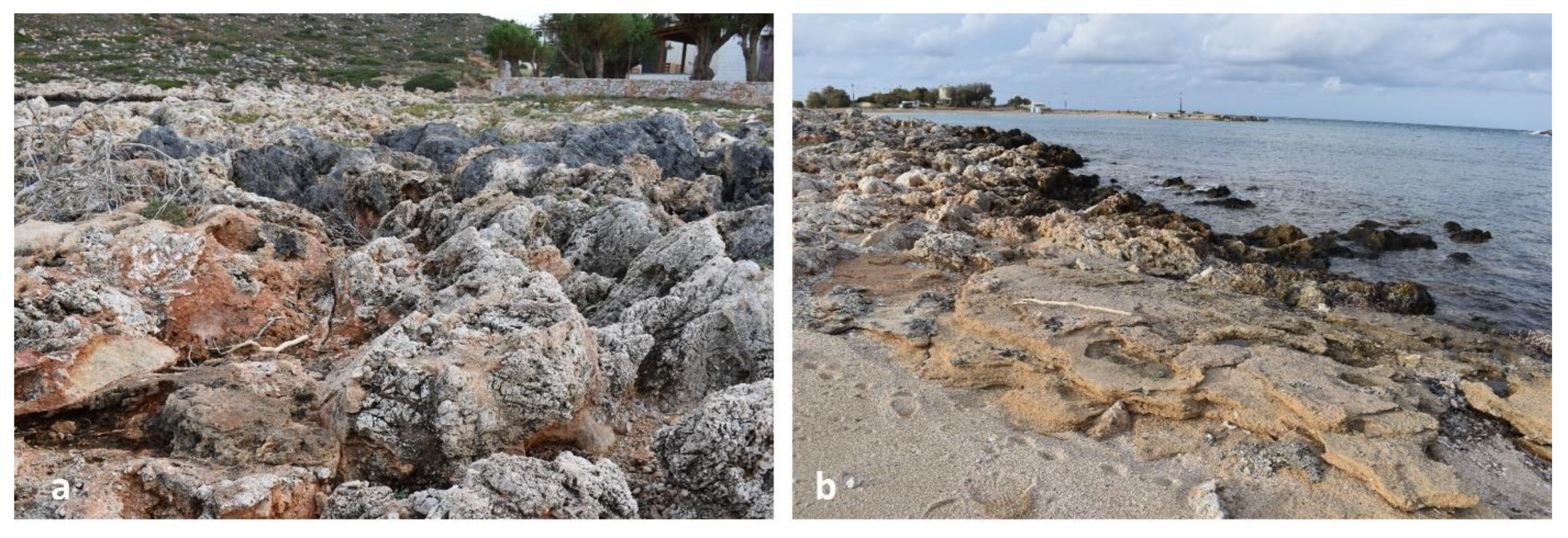
Figure 6.
The two figures (a,b) from the quarry at Stavros Bay, Akrotiri, Crete, illustrate detailed sections of paleosols preserved within aeolianite deposits, reflecting distinct stages of pedogenesis and varying environmental conditions during their formation. The white ruler is 25 cm long and the vertical stick (1 meter) used as a scale indicator. .
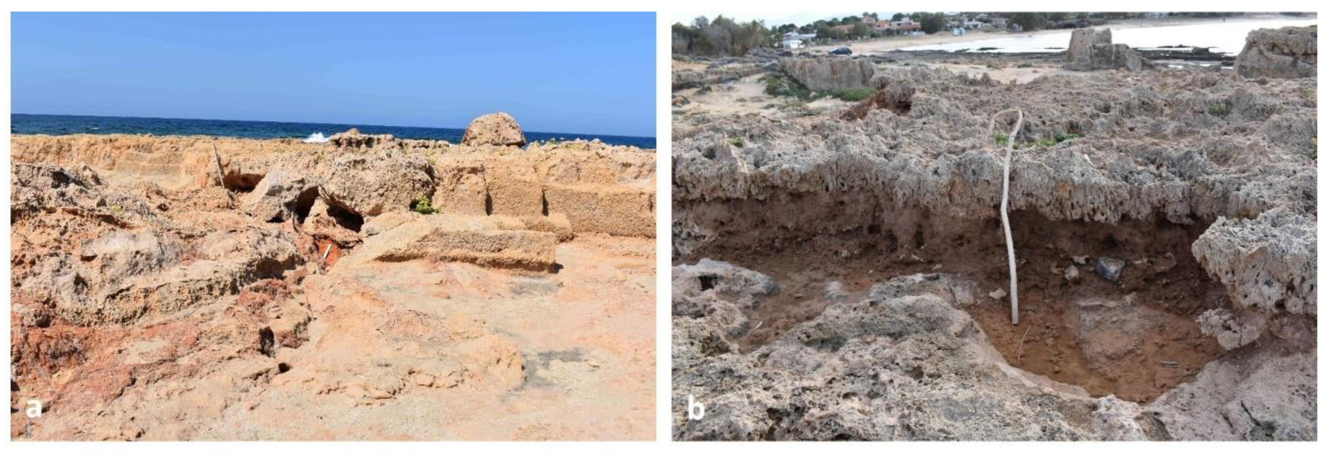
Figure 7.
(a) Cross-bedded aeolianite exposure showing well-developed horizontal and inclined laminations, indicative of dune foreset structures. The pitted surface texture reflects selective weathering of partially cemented carbonate sands. The presence of vertical root traces suggests colonization by vegetation during periods of dune stabilization, supporting rhizolith formation and early pedogenesis; (b) Densely cemented aeolianite outcrop with horizontal stratification and evidence of post-depositional bioturbation. The compact, micritic matrix and undisturbed bedding suggest advanced diagenesis under stable surface conditions. Vertical root penetration highlights the influence of vegetation on dune stabilization and the development of rhizogenic carbonate features. The vertical stick (1 meter) provides scale reference.
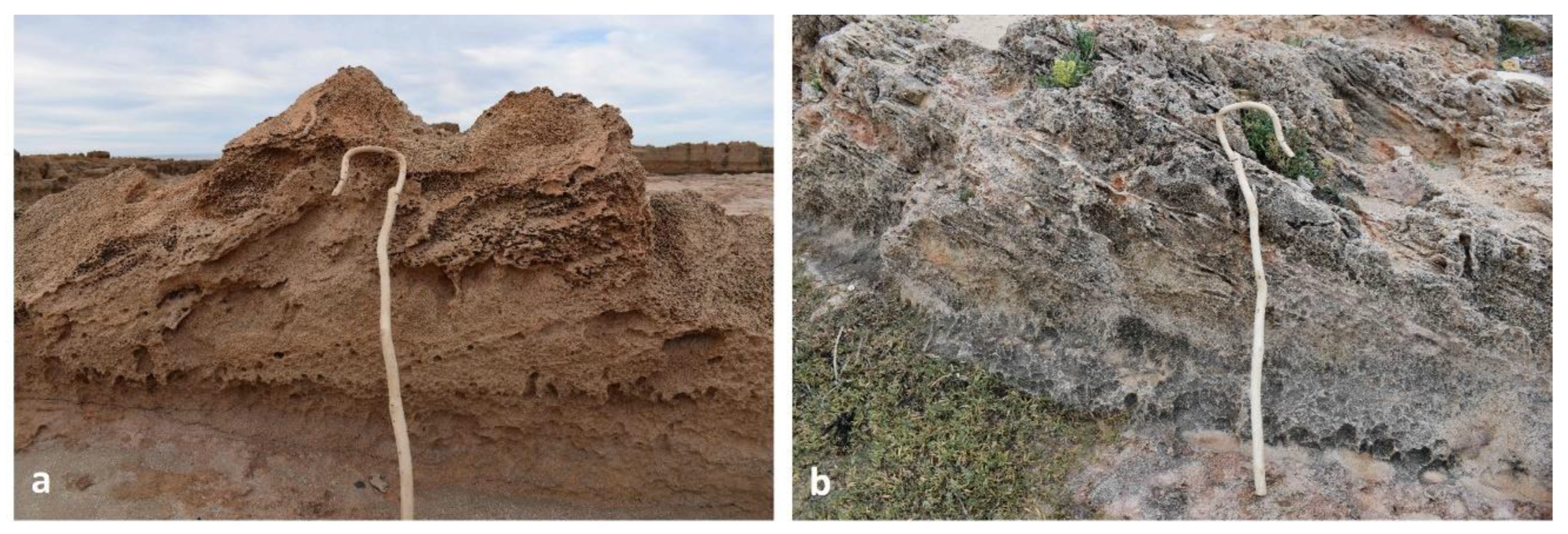
Figure 8.
Figure (a) shows a complex structure where multiple rhizoliths are preserved within a hardened calcrete matrix (hardpan). The rhizoliths appear as elongated, lighter-colored tubular structures embedded within the brownish-tan sedimentary deposit. One particularly prominent rhizolith extends across the surface, with a 25 cm measuring ruler placed alongside it for scale. The surrounding matrix shows the characteristic rough, nodular texture of calcrete, which has been formed through pedogenic processes in this coastal environment. Figure (b) presents a view of individual rhizoliths in profile within a calcrete horizon. Roots’ structures retain their original morphology, including the branching and what appears to be a slight curve typical of plant roots penetrating through soil. The surrounding sediment shows distinct layering with reddish-brown calcrete horizons.
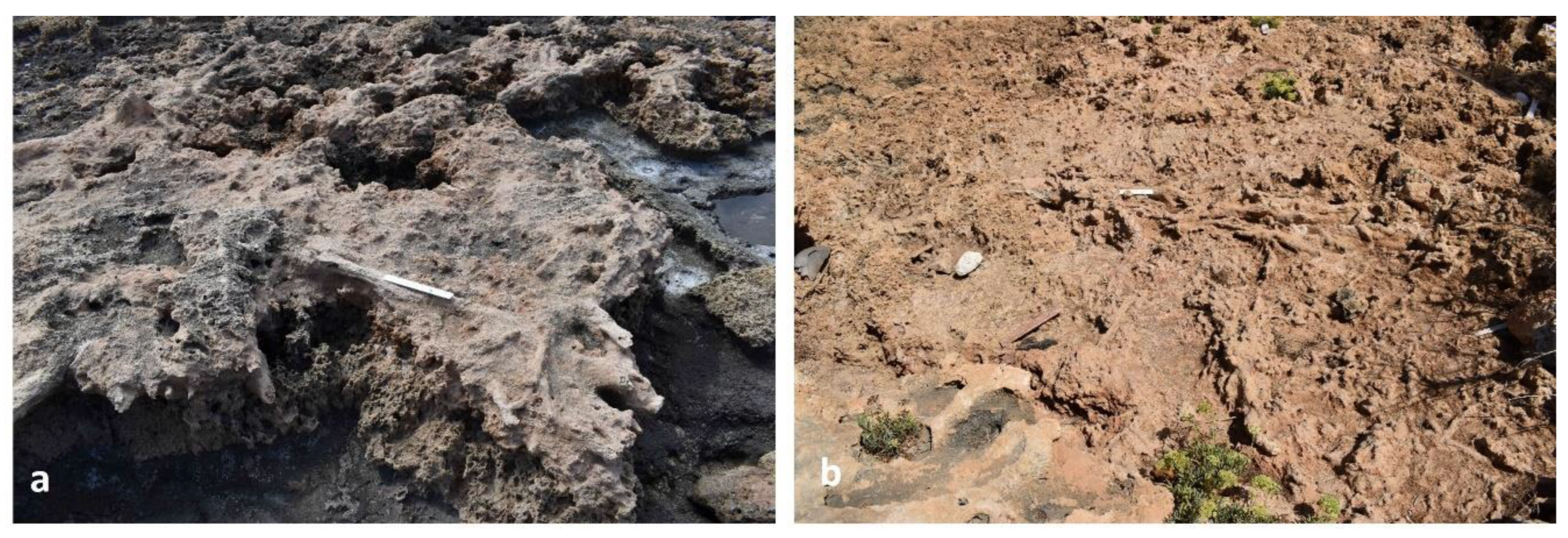
Figure 9.
The figures (a,b) illustrate particularly well-developed tubular rhizoliths embedded within a porous and strongly weathered carbonate substrate. Both figures intricate networks of interconnected cylindrical root casts, indicative of dense past vegetation cover and intense pedogenic processes within the host paleosol [21,108]. These rhizoliths are characterized by cylindrical morphology and exhibit excellent preservation of the original root system geometry. Τhe smooth, tube-like morphology correspond to the definition of a root cast according to Klappa [21], reflecting early cementation of host dune sands following root decay. The ruler 35 cm long is used as a scale indicator.
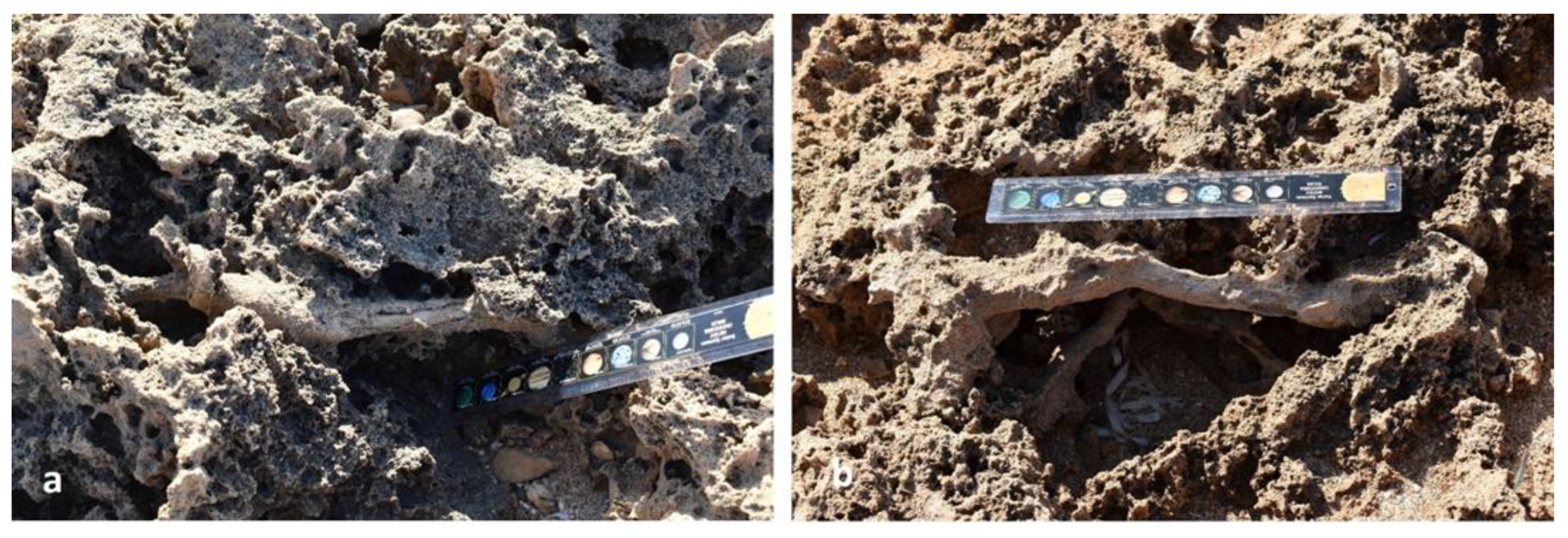
Figure 10.
(a) Extensive laterally branching fossilized root system (rhizolith) exposed on the surface of α hardpan. The calcified roots preserve complex bifurcating architecture consistent with in-situ vegetation, with micritic carbonate precipitated around living or decaying roots; (b) Well-preserved network of horizontally sprawling fossilized roots forming a rhizocretionary system in friable carbonate-rich aeolianite. The branching morphology and preservation indicate early diagenetic calcification in a vegetated dune setting. the rhizoliths in both fotos are fossilized roots sensu Klappa [21], reflecting prolonged surface stabilization and root-soil interaction The white ruler 25 cm long used as a scale indicator.
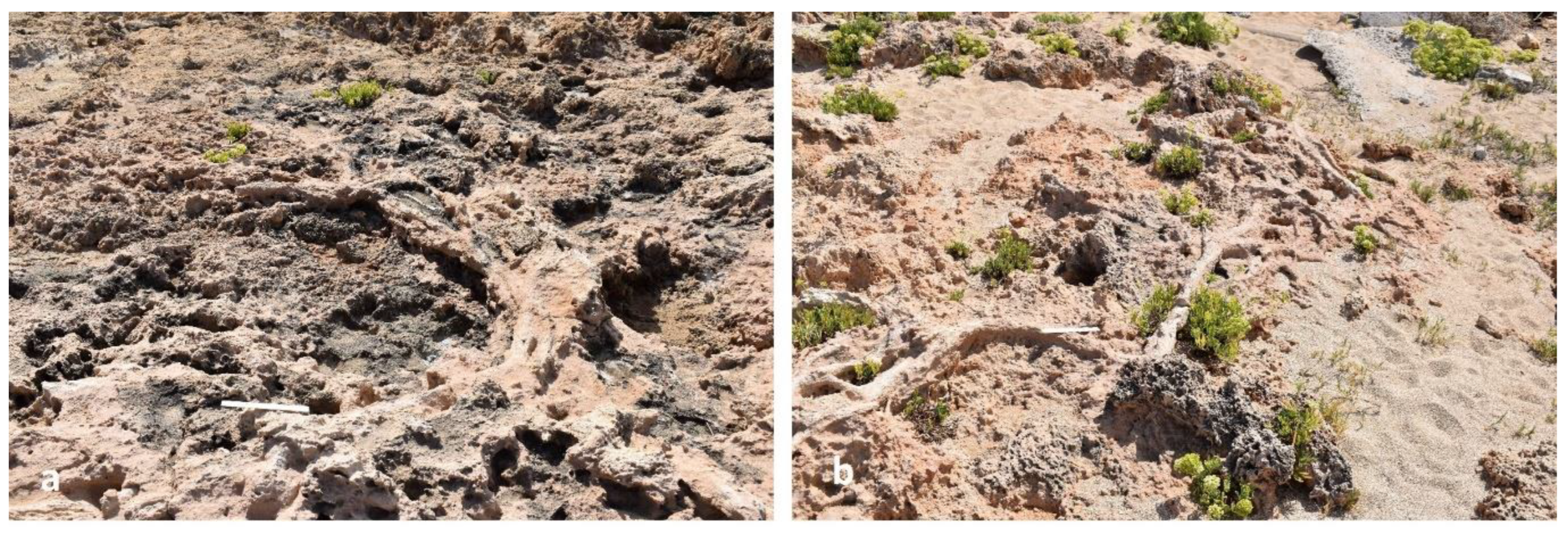
Figure 11.
The structures exhibit in-situ geometry with downward tapering and micritic carbonate coatings, indicative of early diagenetic calcification around active root channels during phases of surface stabilization (fossilized roots sensu Klappa [21]). (a) Vertically oriented, branching fossilized root system preserved beneath a well-developed hardpan horizon. The root system displays multiple lateral branches extending outward and downward from a central axis, indicating a complex, biologically active rhizosphere. The complex lateral branching and micritic carbonate encrustation indicate in-situ calcification under stable pedogenic conditions, consistent with fossilized roots; (b) Thick, unbranched fossilized roots arranged in parallel orientation within a friable aeolianite matrix. Unlike the root in image a, there is no visible branching, suggesting they represent primary roots of larger plants or trees that developed in more compact or quickly buried conditions. Their size and spacing suggest deep-rooting vegetation, with early carbonate cementation preserving the roots as massive, fossilized structures. The white ruler is 25 cm long and the vertical stick (1 meter) is used as a scale indicator.
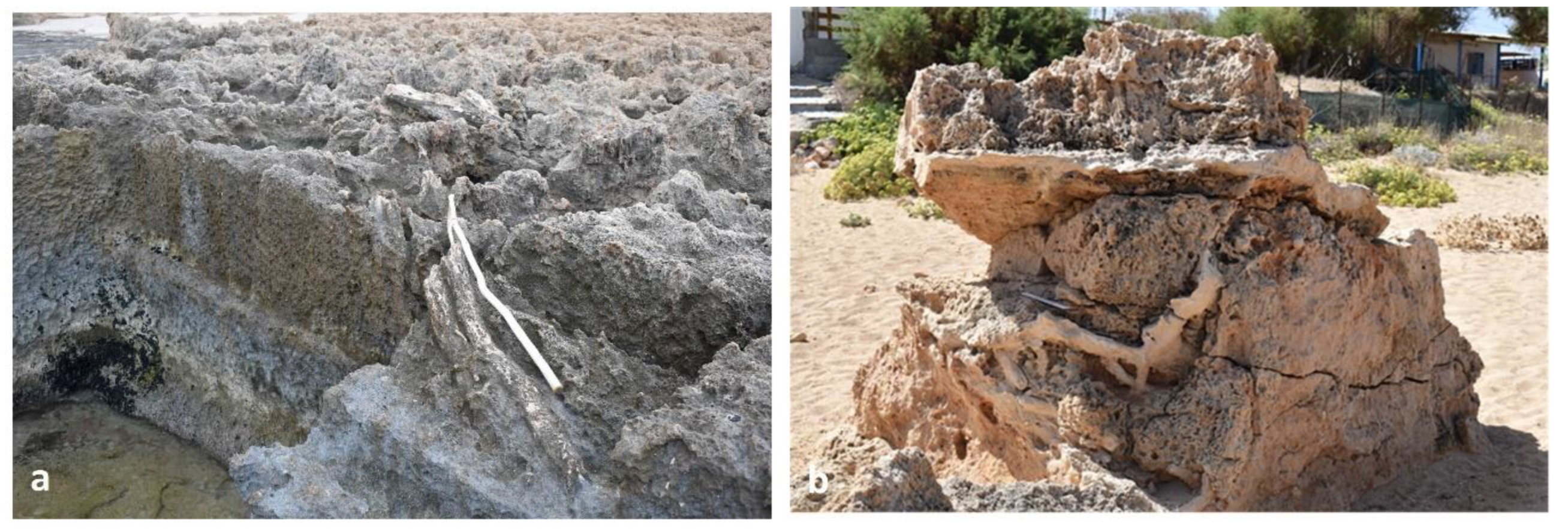
Figure 12.
These microphotographs (a-f), likely from thin sections under polarized light, reveal detailed internal features of carbonate rhizoliths. Notable structures include ring-like patterns, remnants of roots that have partially dissolved, leaving voids or slightly filled central channels [110]. Some areas clearly show internal stratification, possibly representing preserved epidermal or cortical root tissues. Such microstructures are characteristic of biogenic calcification and offer insight into the preservation of plant organics during early diagenesis. Their identification helps reconstruct the biological and environmental processes that led to their formation. For scale the red line below the numbering is 1 mm.
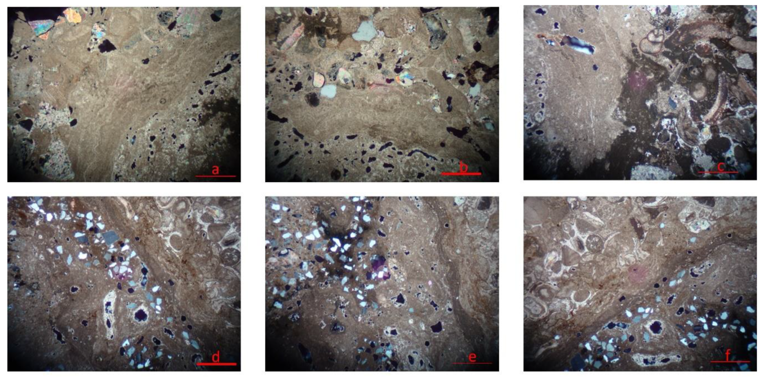
Figure 13.
All images (a-f) also depict carbonate rhizoliths in thin section under polarized light, with red scale bars indicating a length of 1 mm. The rhizoliths exhibit clear zonation, alternating between micritic and microsparitic calcite, which is typical of rhizoliths formed under fluctuating soil moisture conditions. The concentric zoning and micritic envelopes reflect episodic changes in groundwater chemistry and carbonate saturation, with variations possibly driven by seasonal or climatic shifts [29]. The fine preservation of internal microstructures further supports the interpretation of these features as root-derived, secondary carbonate accumulations formed under semi-arid pedogenic regimes [30,32].
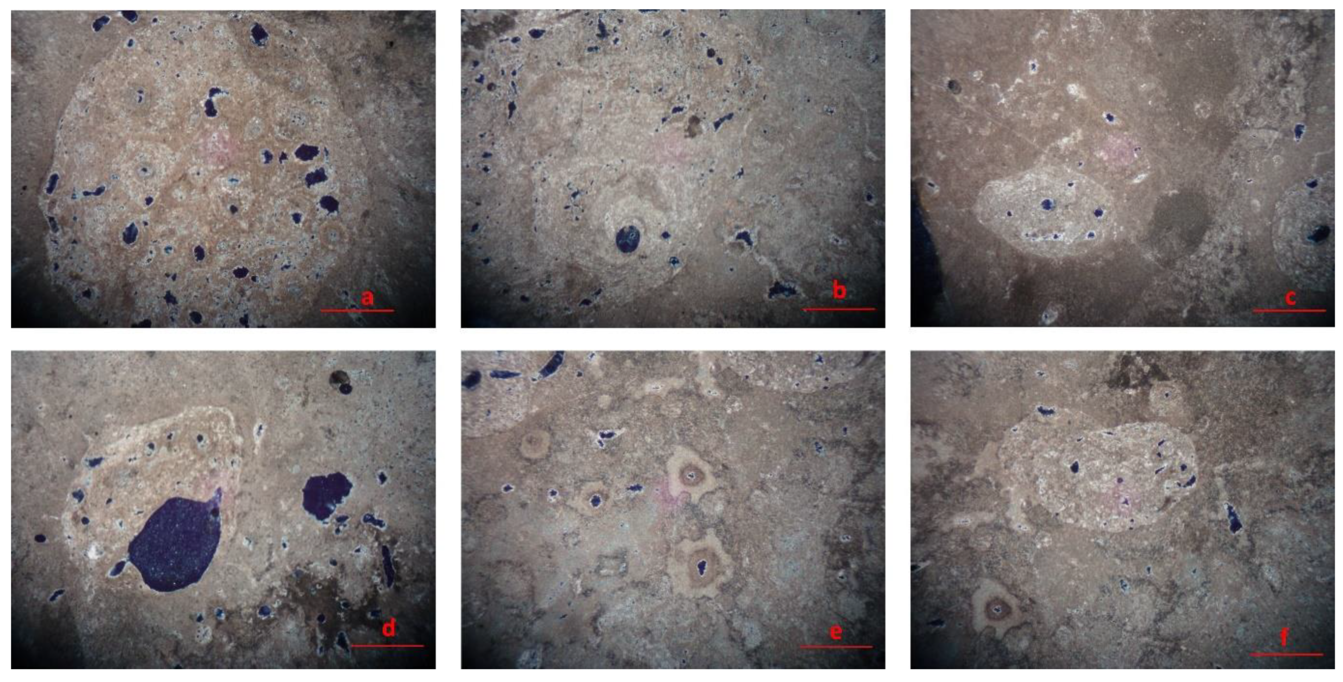
Figure 14.
(a) Irregular depressions in lithified coastal carbonate rocks interpreted as tree pits—erosional remnants of in-situ fossilized tree bases. These cavities likely formed around calcified trunks and roots that were later removed or eroded, leaving behind hollow biogenic molds. The surrounding substrate consists of cemented aeolianite, shaped by subaerial exposure and diagenetic alteration; (b) Calcified tree stump preserved in vertical position within friable carbonate-rich aeolianite. The structure retains branching morphology and appears in association with rhizolith fragments scattered on the surface. These features reflect in-situ calcification of woody vegetation within a vegetated coastal dune system, followed by partial exhumation and erosion.
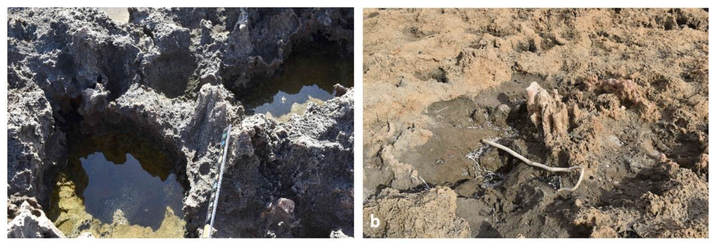
Figure 15.
(a) In-situ upright fossilized tree trunks preserved in growth position within carbonate aeolianite. The vertical orientation and clustering of the trunks indicate rapid burial—likely by aeolian sands—prior to decomposition, supporting their interpretation as part of a Rhizolith petrified forest formed under coastal dune conditions. Calcification, rather than silicification, facilitated the preservation of both below-ground and above-ground plant structures; (b) Close-up of a calcified fossil trunk surface showing fine preservation of cortical texture and concentric structural features. The granular micritic to microsparitic carbonate matrix reflects low-energy burial conditions and gradual mineralization, consistent with pedogenic calcification in a coastal dune environment.
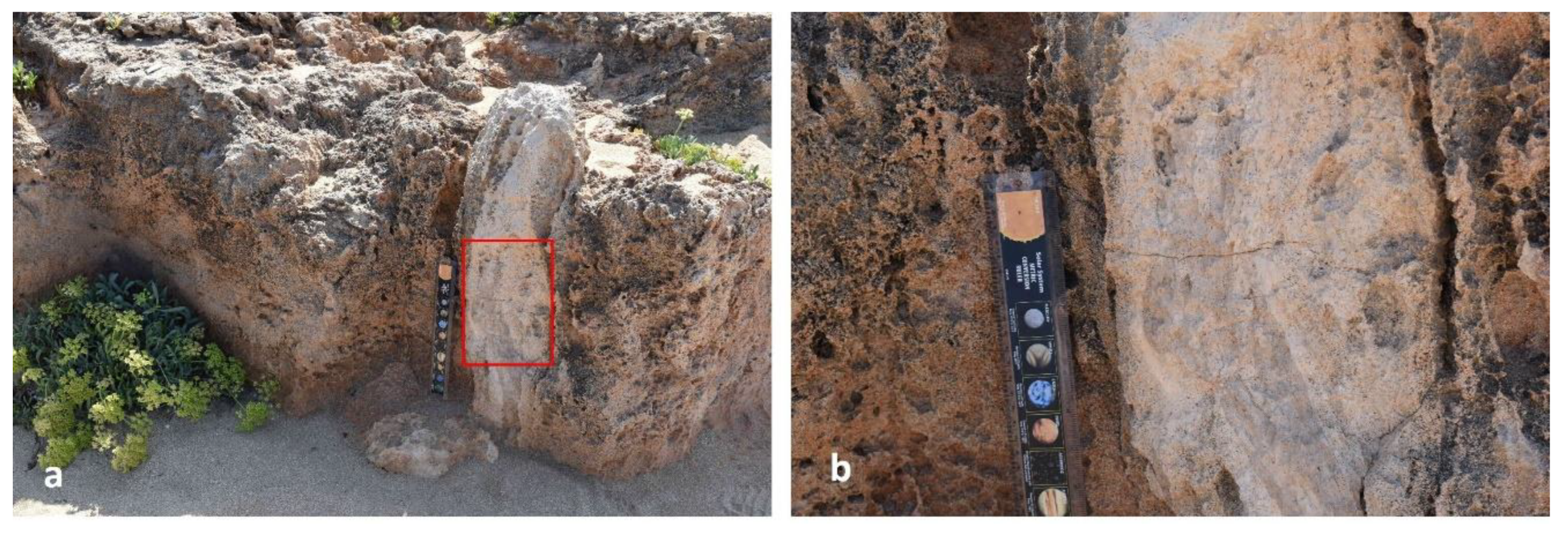
Figure 16.
The figures illustrate elongated, robust fossilized structures identified clearly as fossilized tree branches preserved within carbonate-rich aeolian deposits, distinguished morphologically and dimensionally from typical rhizoliths.
Figure 16.
The figures illustrate elongated, robust fossilized structures identified clearly as fossilized tree branches preserved within carbonate-rich aeolian deposits, distinguished morphologically and dimensionally from typical rhizoliths.
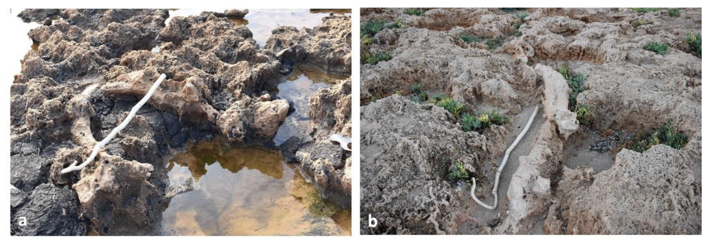
Figure 17.
Vertical solution pipes within aeolianites at Stavros Bay, Akrotiri, partially infilled and contain fossilized rhizoliths. These root traces likely initiated localized carbonate dissolution, forming the pipes under semi-arid conditions with episodic soil formation.
Figure 17.
Vertical solution pipes within aeolianites at Stavros Bay, Akrotiri, partially infilled and contain fossilized rhizoliths. These root traces likely initiated localized carbonate dissolution, forming the pipes under semi-arid conditions with episodic soil formation.
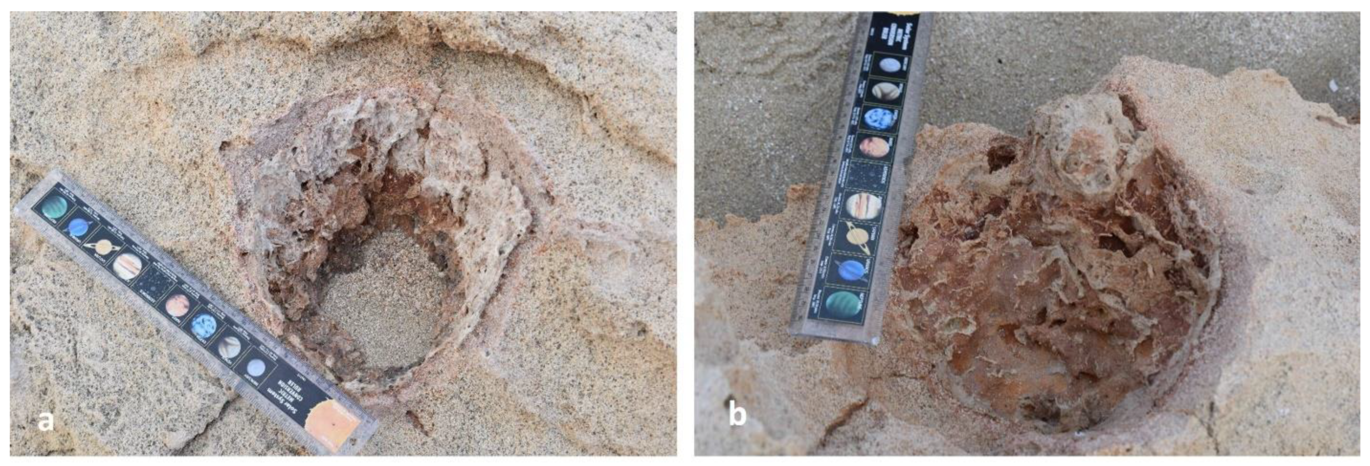
Figure 18.
“Rock pools” or tree pit–like depressions in aeolianites at Stavros Bay, Akrotiri, resembling root hollows from the Late Visean fossil forest at Catcraig, Scotland [117]. Likely formed by root growth and decay, these features reflect early pedogenesis and vegetative stabilization of the substrate.
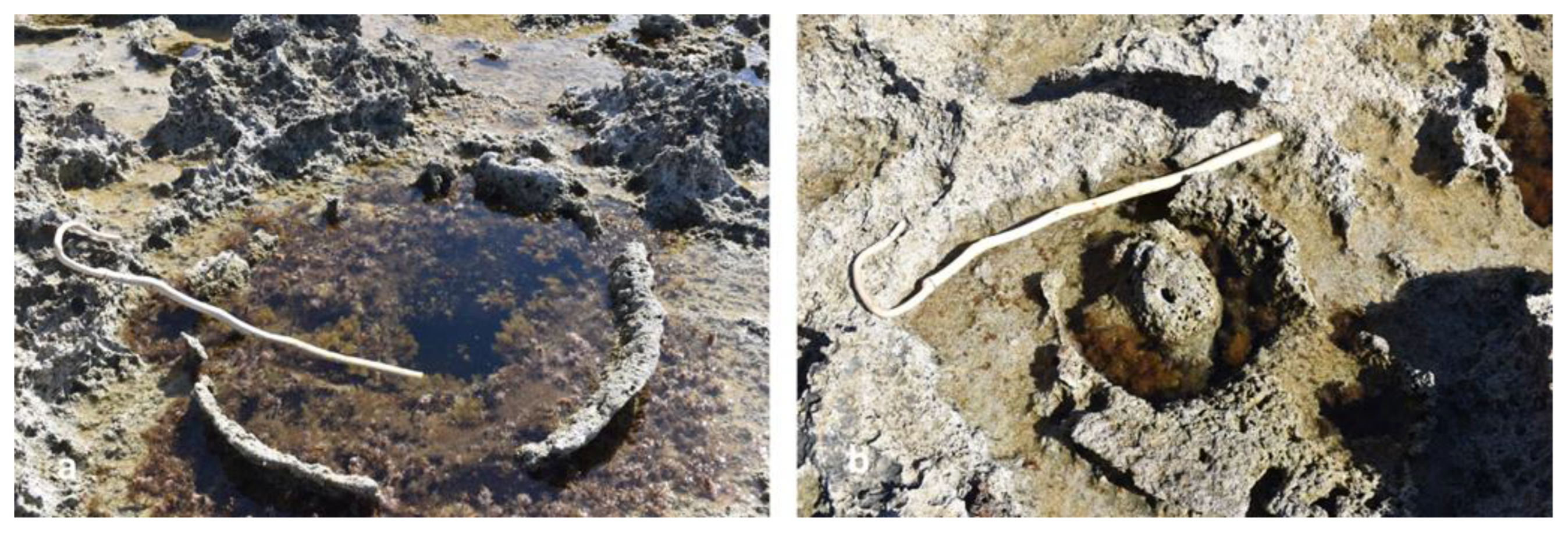
Disclaimer/Publisher’s Note: The statements, opinions and data contained in all publications are solely those of the individual author(s) and contributor(s) and not of MDPI and/or the editor(s). MDPI and/or the editor(s) disclaim responsibility for any injury to people or property resulting from any ideas, methods, instructions or products referred to in the content. |
© 2025 by the authors. Licensee MDPI, Basel, Switzerland. This article is an open access article distributed under the terms and conditions of the Creative Commons Attribution (CC BY) license (http://creativecommons.org/licenses/by/4.0/).
Copyright: This open access article is published under a Creative Commons CC BY 4.0 license, which permit the free download, distribution, and reuse, provided that the author and preprint are cited in any reuse.


