
Submitted:
04 April 2025
Posted:
08 April 2025
Read the latest preprint version here
Abstract
The main focus is on the cultural, solar, and environmental large-scale contexts that impact small traditional agricultural plots, following the technical input data of agrivoltaics solar power or fish-friendly micro hydropower, considering the cultural landscape. The case study on an existing polder addresses several environmental issues, risk management concerns, energy requirements, and aspects of renewable energy transition, including potential solutions and their impact. Cultural landscape, agricultural plot management, and ecology focusing on traditionally inspired design in rural wetland areas in Romania, Technical vs. Humanistic as a solving path through some inspiring "Dyads" is emphasised in the proposed paper.
Keywords:
Holistic Framework
; Energy – Nature – Built
; Solar Regeneration
; Solar Photovoltaics
; Agrivoltaics
; Solar Storage
; Traditional plot landscape
; River landscape
| Desirable Small-Scale Solar Power Production in a Global Context: Local Tradition-Inspired Solutions to Global Issues | 1 |
| Introduction | 3 |
| Methodology | 4 |
| Methodology - Knowledge vs. Understanding Solar Regeneration-related Dyads | 4 |
| NATURE — Regenerative Dyad “Tradition vs. Technology” | 6 |
| BUILT — Regenerative Dyad “Humanist vs. Technical” | 8 |
| ENERGY —Regenerative Dyad “Passive vs. Active” | 9 |
| New BUILT [S-SV] vs [Z-AR] Regenerative Dyad “Humanist vs. Technical” | 10 |
| Traditional rural plots [S-SV] vs [Z-AR] Antropocen agricultural plots | 10 |
| BUILT [S-SV] Study case Traditional rural plots – Boroaia, Suceava county, Romania | 9 |
| BUILT [Z-AR] Study case Anthropocene Agricole plots - Zerind Polder, Arad County, Romania | 11 |
| New NATURE [Z-AR] Regenerative Dyad “Tradition vs. Technology” | 16 |
| New ENERGY [Z-AR] Regenerative Dyad “Passive vs. Active” [Z-AR] | 17 |
| Agrivoltaics production | 19 |
| Photovoltaic covering irrigation canals | 20 |
| Solar storage potential | 27 |
| Conclusion | 29 |
| Discussions | 31 |
| Acronyms | 32 |
| Acknowledgements | 32 |
| Bibliography | 25 |
Introduction
The cultural landscape presents a visual, auditory, and olfactory mosaic of material, defined phenomenologically through experiences and events that generate and reveal its history. The rural regions to be analysed are located in two distinct areas of Romania: Zerindu polder, Arad County, Romania [Z-AR], as agricultural plots, and a family plot from Săcuţa locality, Boroaia, Suceava County, Romania [S-SV]. The conventional wetland, located in Arad County, was designed as a non-permanent water accumulation area. [Z-AR]2 vs [S-SV] Suceava County, an area at the confluence of two watercourses with fluctuating flows, naturally creates a temporary wetland. The connection between the two sites seems coincidental, following an exodus of over 150 families from a village in Banat, located in the Suceava area, due to a plague epidemic in the 15th century. We can only assume that some of them or their know-how was transmitted by some C. family members, according to the words of some old Boroaia teacher and details that are not very specific in the village monograph.
The area of the village of Boroaia [S-SV] has relatively unproductive agricultural lands. For this reason, and due to the morphological environment, some risk management works related to the watercourse are considered risk management according to current norms. However, the hydrotechnical works in [S-SV] Boroaia, Suceava County, were determined by the eloquently named watercourse, Seaca/tr Drought, which presents torrent-like flow fluctuations. Such techniques are not specific to the Moldova River basin’s ethnological or morphological geographical area. They seem to have emerged by acquiring technical Knowledge from migrants from a traditional wetland area, such as Arad County. The migrants implemented secular agricultural practices, including water management systems, which were traditional in the distinct support areas with a Neolithic history. However, they could find this locally, having transferred know-how from the Arad area, specifically from or near the Zerind polder area. So the other location to be analysed, Zerind Polder [Z-AR]3, is a temporary dam area enclosed by dikes, which demonstrates human adaptation to the conditions of wetlands through traditional Anthropocene engineering but which can also be historically documented as the implementation of landscape-specific techniques (ditches as crop boundaries, plots linked to dwellings/households delimited by arranged ditches). A network of rivers and streams characterises both sites, and the creation and management of water channels have shaped a cultural landscape with a specific set of traditional activities over time. Traditional property boundaries mark the landscape, and agricultural plots reflect historical land use patterns through the design and management of indigenous ditches versus modern Anthropocene adaptations of flood risk management, such as the construction of dikes and polders.
The Boroaia traditional rural plots and the Zerind Polder case studies offer a rich contrast, showcasing how traditional Knowledge can design modern sustainable practices. The Boroaia case examines historical land use patterns, water management systems, and indigene cultural practices conserved in a vernacular village, Sacuta. At the same time, the Zerind Polder [Z-AR]4 represents a more contemporary approach to agricultural production within the Anthropocene era.
The final sections of the paper delve into the technical specifics of solar energy production and storage in agricultural settings. The research will provide a detailed analysis of various agrivoltaic configurations. The final sections of the paper delve into the technical specifics of solar energy production and storage in agricultural settings. The research provides a detailed analysis of various agrivoltaic configurations, their efficiency, and their integration with traditional farming practices. They also explore the potential of green hydrogen production and fish-friendly micro hydropower as complementary energy storage solutions.
The paper’s conclusion synthesises the key findings, revisiting the core dyad relationships and presenting a comprehensive SWOT analysis of the technical strengths of their hybrid approaches, such as the successful integration of agrivoltaic systems and modernised temporary dam systems. On the humanistic side, they highlight the preservation of cultural landscapes and traditional farming knowledge. The paper presents a comprehensive study on integrating indigenous and conventional agricultural practices with modern renewable energy systems. The study examines how cultural heritage and local Knowledge can inform sustainable energy solutions, focusing on agrivoltaics and restoring the existing polder systems with nature-based solutions.
Methodology
The paper begins by establishing the study’s theoretical foundation, drawing on Bennett’s Systematics and the concept of the Solar Regeneration Monad5. The research introduces three key dyads to guide their analysis: Technology vs. Tradition, Technical vs. Humanist, and Active vs. Passive. These dyads are presented not as contradictory forces but as complementary elements that must be understood and balanced for effective and sustainable development.
The methodology section outlines the research approach to analysing these dyads across multiple scales, from individual agricultural plots to global contexts. They emphasise the importance of integrating traditional Knowledge and modern technical Understanding, using a spiral process to move from “Knowledge” to “Understanding” in each domain.
The chapter on the NATURE dyad explores the relationship between traditional and technological approaches in environmental management. The research focuses on biodiversity metrics, carbon sequestration potential, and the integration of conventional and indigenous water management systems with modern agricultural technologies. A particular focus is placed on the role of wetlands and their preservation in the face of Anthropocene-driven changes.
The BUILT dyad examines the intersection of humanistic and technical approaches in agricultural infrastructure and energy production. The research examines the assessment of cultural heritage, traditional building practices, and the adaptation of rural structures for the integration of renewable energy. Case studies of traditional rural plots in Boroaia and Anthropocene agricultural plots in the Zerind Polder highlight how this balance can be achieved.
The ENERGY dyad explores the relationship between passive and active energy systems, analysing carbon footprint, water footprint, and the potential for renewable energy generation. The research presents detailed assessments of agrivoltaic systems, translucent photovoltaic coverings for irrigation canals, and the integration of fish-friendly micro-hydropower.
Dyad proposed it related to a Monad after Bennett Systematics was “Knowledge vs. Understanding.” 6
Dyads proposed related to a “Solar Regeneration” Monad are as follows:
- “Technical vs. Humanist” as BUILT Criteria
- “Technology vs. Tradition” as NATURE Criteria
- “Active vs. Passive” as ENERGY Criteria
The theme relevant in the DYAD-related context is “vs.” or “Together despite opposites’“. “Knowledge” without “Understanding” is somewhat equivalent to “Technical” / “Technology” / “Active” without their opposites: “Humanist” /” Tradition”/”Passive”, all opposites together without prioritisation.
The Dyad needs the impulse to move in a Triad understanding process. The spiral is proposed as a process to achieve a monad; the impulse required, in addition to the Dyad opposing terms, is the grow-degrow impulse. A process is required to translate the “Knowledge” criteria into “Understanding”. Bennett’s systematics offers a set of regulations applicable to the abstract, an academic way of reaching “Understanding” - through the antithesis-thesis (Dyad) to the Hegelian dialectic (thesis, antithesis, synthesis), similar to the impulses of Bennett’s Triad. The Hegelian dialectic offers a way of developing in a one-way spiral. But Bennett’s Triads provide a way of gaining and re-gaining through a double-way spiral covering the “Knowledge” necessary for achieving “Understanding” and making a multicriteria decision essential in any holistic solution. The spiral way sketches note the equal weight of the knowledge metaphors in the creation of the rosette: B—BUILT+ E—ENERGY+ N—NATURE on the scales from small to large, O—Object, L—Locality, T—Territory, G—Global, applied for projects on any starting points.
Methodology - Knowledge vs. Understanding Solar Regeneration-related Dyads
Dyads - Knowledge vs Understanding as Technology vs. Tradition / Technical vs. Humanist / Active vs. Passive
“Knowledge vs. Understanding “ is the Dyad according to the views of Bennett, who detailed systematics to make the transition from “Knowledge” to “Understanding”, which usually requires experimentation.
So the “vs”/versus inside the main Dyads means “opposite but together” and represents the research Gaps of the “Solar Regeneration” Monad we try to whole. We can develop a “3—Active vs. Passive” Dyad related to the Energy transition from Energy Criteria or the same “2—Technology vs. Tradition” Dyad in the Ecological transition of Nature Criteria; a “1—Technical vs. Humanist” Dyad related to an Urban metabolism for the Built Criteria.
KNOWLEDGE is defined through TECHNICAL criteria for NATURE – BUILT - ENERGY7 and is somewhat partially related to ENVIRONMENT-SOCIAL-GOVERNANCE in many ways.
Figure 1.
Methodology Dyads related + growth-degrow process required as follows8: Regenerative Monad: Dyad, according to Bennett,9 “—Knowledge” learned or transmitted requires a grow-degrow process for achieving “—Understanding” that typically involves experimentation. 1—Nowadays, Regenerative, the New Dyad “1—Tradition” needs to be perfected after many “1—Technology” implementations on different scales in a growth-degrow fine-tuning process. 2—Nowadays, Regenerative, the New Dyad “2—Humanist” needs more “2—Technical” accomplishments, which are often repeated in the same fine-tuning grow-degrow process. 3—Nowadays, Regenerative, the New Dyad “3—Passive” achievement is flawless through an optimal “3—Active” after a growth-degrow fine-tuning process.
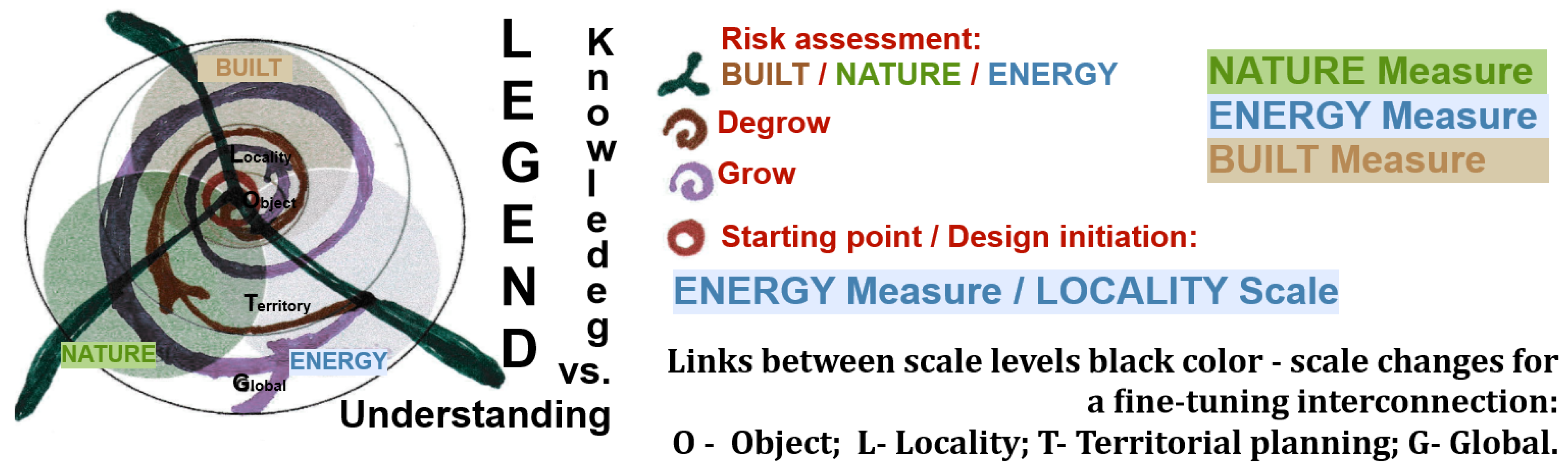
Figure 2.
Methodology Dyad Knowledge vs Understanding, “the Knowledge vs Understanding diagram”10: Legend Scales O Object; L Locality; T Territory; G Global/ N Nature + B Built +E Energy; Grow – Degrow process
from a Starting point, as Locality scale – polder / ENERGY area; Inflexion point from Grow to Degrow at Global / ENERGY scale level.
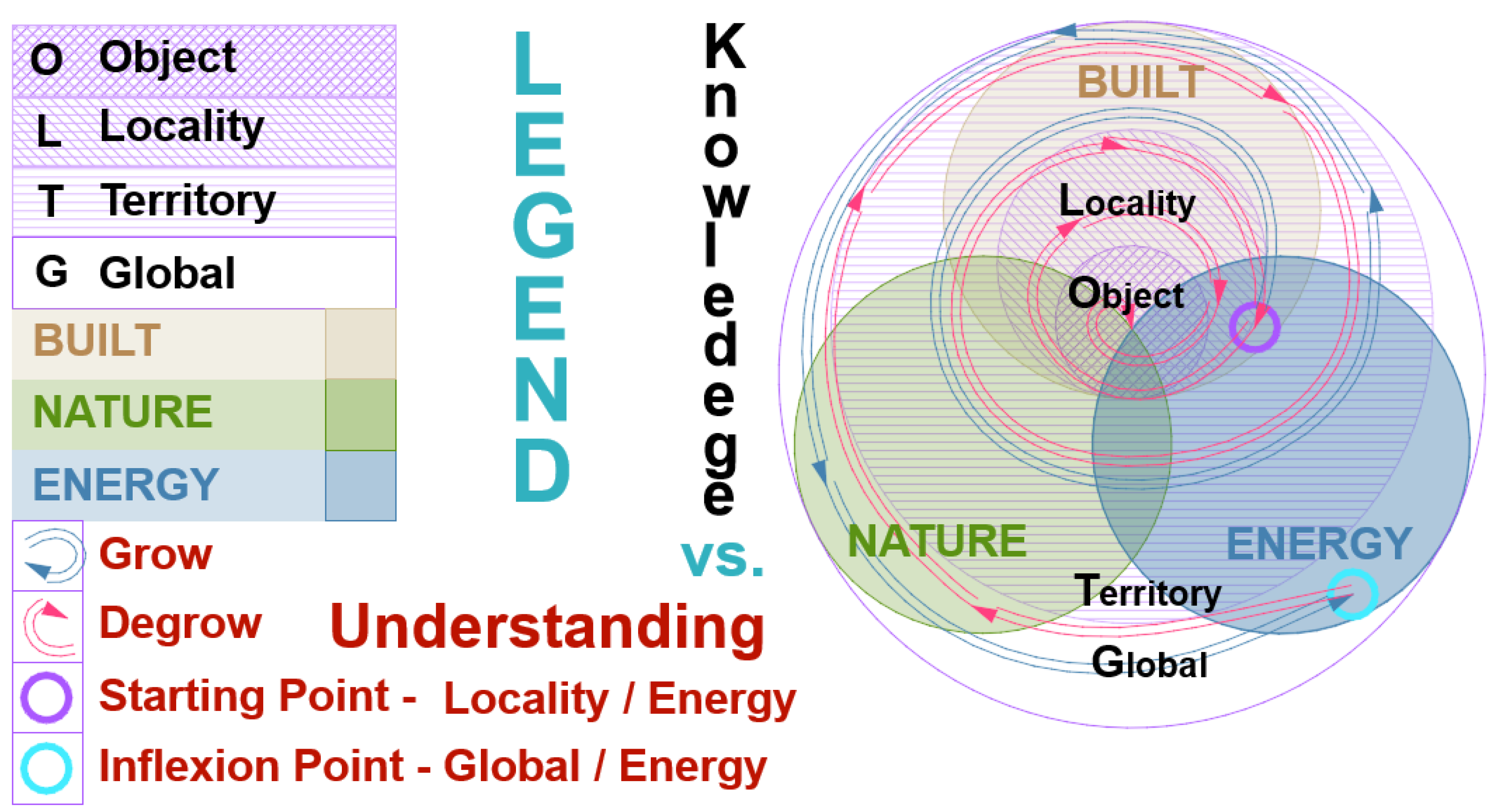

Table 1.
Criteria related to Knowledge like/ 1-Technology, 2- Technical, 3–Active to achieve 1-Tradition, 2-Humanist, 3-Passive/as Understanding.
Table 1.
Criteria related to Knowledge like/ 1-Technology, 2- Technical, 3–Active to achieve 1-Tradition, 2-Humanist, 3-Passive/as Understanding.
| Acronym | measure↓ | LEGEND - MEASURE/SCALE | |
|---|---|---|---|
| N - O | Nature - Object | NATURE Technology | OBJECT plot scale |
| N - L | Nature - Locality | NATURE Technology | LOCALITY dam/polder scale |
| N - T | Nature - Territory | NATURE Technology | TERRITORY hydrologic basin scale |
| N - G (*) | Nature - Global (*) | NATURE Tradition | GLOBAL scale (*) |
| B - O | Built - Object | BUILT Technical | OBJECT plot scale |
| B - L | Built - Locality | BUILT Technical | LOCALITY dam/polder scale |
| B - T | Built - Territory | BUILT Technical | TERRITORY hydrologic basin scale |
| B - G (*) | Built - Global (*) | BUILT Humanist | GLOBAL scale (*) |
| E - O | Energy - Object | ENERGY Active | OBJECT plot scale |
| E - L | Energy - Locality | ENERGY Active | LOCALITY dam/polder scale |
| E - T | Energy - Territory | ENERGY Active | TERRITORY hydrologic basin scale |
| E – G (*) | Energy – Global (*) | ENERGY Passive | GLOBAL scale (*) |
| (*) The Global scale is the “correct assessment,” including sine qua non-design principles, and the Humanist related to Understanding. | |||
Table 1.
EU Taxonomy criteria 11DNSH principle [Do No Significant Harm]
| 1 | DNSH Climate change mitigation | renewable energy production | Substantial contribution |
| 2 | DNSH Climate change adaptation | flood protection | Substantial contribution |
| 3 | DNSH The sustainable use and protection of water and marine resources | Polder - wetland | Substantial contribution |
| 4 | DNSH The transition to a circular economy | recycled materials, preserved built works | DNSH |
| 5 | DNSH Pollution prevention and control | attention needed - materials | DNSH |
| 6 | DNSH The protection and restoration of Biodiversity and ecosystems | Wildlife corridors with biocapacity/biodiversity - wetland impact | Substantial contribution |
NATURE12 — Regenerative Dyad “Tradition vs. Technology”
The Dyad examines the relationship between traditional and technological approaches in natural contexts, focusing on Biodiversity, agriculture, and environmental management. The research analyses how traditional agricultural practices and modern technological solutions can be integrated to enhance Biodiversity and ecological sustainability. The analysis is conducted across different scales, from individual plots to entire ecosystems. Specific attention is given to the role of wetlands, traditional water management systems, and their integration with modern agricultural technologies. The chapter includes a detailed assessment of biodiversity metrics, carbon sequestration potential, and the impact of different land management approaches on natural systems.
Table 3.
NATURE 1—Nowadays, the New “1—Tradition” needs to be perfected after many “1—Technology” implementations on different scales in a growth-degrow process.
Table 3.
NATURE 1—Nowadays, the New “1—Tradition” needs to be perfected after many “1—Technology” implementations on different scales in a growth-degrow process.
| Scale Global correct assessment | |||||
| Green | Agriculture | Blue | Biodiversity | Soil | Risks related |
| Increased Biodiversity of local species measures (after invasive species issues). | Following the Anthropocene-specific era of industrial agriculture, locally adapted cultures for regenerative, Pesticide-free European agriculture. | Water management - longitudinal connectivity & transversal connectivity related to wild corridors (after Anthropocene excessive Hydropower measures, excessive micro hydro number). | Wetland areas and longitudinal watercourse connectivity (following the Antropocene’s decreased Biodiversity). | Soil health measures are needed after Antropocene-specific soil degradation. | Risks relevant to energy production are to be evaluated. |
| Scale Object - plot | |||||
| Green | Agriculture | Blue | Biodiversity | Soil | Risks related |
| Increasing biocapacity/ biodiversity | Increasing Biodiversity | Irrigation canals needed/ ponds needed | Increasing biodiversity measures | Pesticide-free crop rotation | Energy production to be evaluated. |
| Scale Locality - dam/polder | |||||
| Green | Agriculture | Blue | Biodiversity | Soil | Risks related |
| Increasing biocapacity/ biodiversity | Increasing Biodiversity | Irrigation canals needed/ ponds needed | Biodiversity improvement measures, such as meander renaturation | Pesticide-free crop rotation in agricol community | Water/ Energy production to be evaluated. |
| Scale Territory - Hydrological Basin | |||||
| Green | Agriculture | Blue | Biodiversity | Soil | Risks related |
| Increasing biocapacity/ biodiversity | Increasing Biodiversity | Irrigation canals/ ponds needed | Increasing biodiversity measures | Soil health improvement measures | Energy production to be evaluated. |
BUILT13 — Regenerative Dyad “Humanist vs. Technical”
This Dyad analyses the intersection of humanistic and technical approaches in built environments. The research examines how cultural heritage, traditional building practices, and modern technical solutions can be integrated into agricultural and Energy infrastructure. The analysis covers heritage value assessment, cultural landscape preservation, and social aspects of development. Particular attention is paid to adapting traditional rural structures for modern energy production while maintaining their cultural significance. The chapter thoroughly examines how indigene/traditional property boundaries and land use patterns can be preserved while incorporating modern renewable energy systems.
Table 4.
BUILT 2—Nowadays, the New “2—Humanist” needs more “2—Technical” accomplishments, which are often repeated in the same grow - degrow process.
Table 4.
BUILT 2—Nowadays, the New “2—Humanist” needs more “2—Technical” accomplishments, which are often repeated in the same grow - degrow process.
| Scale Global correct assessment | |||||
| Recyclable | Heritage Value |
Cultural Landscape |
Social | Degrowth | Risks related |
| The existing built environment that supports PV systems. | Revitalising the traditional household after vernacular heritage-specific degradation in the Anthropocene. | Revitalising the cultural landscape after a possible Anthropocene-specific degradation | Traditional agricultural plots are needed for energy / agrarian communities’ circular metabolism community.14 |
Revitalising an intangible heritage through measures specific to traditional culture encompasses daily life routines that follow the circadian cycle and agricultural activities that follow the lunar cycle. | Risks relevant to energy production are to be evaluated. |
| Scale Object - plot | |||||
| Recyclable | Heritage Value |
Cultural Landscape |
Social | Degrowth | Risks related |
| Built environment rehabilitation - photovoltaic support | Industrial dams – evaluated as industrial/technical heritage value | Traditional landscape design | Social Impact of Agrarian/ Energy Communities | Agrarian/Energy communities according to a traditional design | risk of aggressive intervention in the cultural landscape |
| Scale Locality - dam/polder | |||||
| Recyclable | Heritage Value |
Cultural Landscape |
Social | Degrowth | Risks related |
| circular metabolism on a large scale as a metropolitan/ basin scale15 | Thematic heritage visit route basinal scale | Cultural heritage preservation | Human-centred measures large-scale, infrastructure interventions with social impact evaluated | Degrowth and interconnectivity in large-scale infrastructure interventions | Energy production / Biodiversity to be evaluated |
| Scale Territory - hydrological basin | |||||
| Recyclable | Heritage Value |
Cultural Landscape |
Social | Degrowth | Risks related |
| Heritage preservation as a circular economy measure | Heritage studies | Cultural landscape studies | circular metabolism16 /Energy/ Agrarian communities | Heritage preservation as a degrow measure | Energy production to be evaluated. |
ENERGY17,18 —Regenerative Dyad “Passive vs. Active”
The Dyad explores the relationship between passive and active energy systems in agricultural contexts. The research analyses different energy generation and consumption approaches, examining carbon footprint, water footprint, renewable energy potential, and energy consumption patterns across various scales. The study includes a detailed assessment of how traditional passive energy systems can be integrated with active solar power generation. The analysis covers specific metrics for energy efficiency and environmental impact, including carbon sequestration potential and water usage efficiency in different agricultural systems.
Table 5.
ENERGY 3—Nowadays, the New “3—Passive” achievement is achieved through an optimal “3—Active” process after a growth-degrowth process.
Table 5.
ENERGY 3—Nowadays, the New “3—Passive” achievement is achieved through an optimal “3—Active” process after a growth-degrowth process.
| Scale Global correct assessment | ||||
|
Carbon footprint |
Water footprint |
Renewable Energy |
Energy Consumption |
Risks related |
| Carbon sequestration through nature-based solutions measures | Related to hydrogen production and hydropower production | Agrivoltaics, translucent solar panels on irrigation canals, micro-hydro fish-friendly | Hydrogen production | Water / Energy / Built / Biodiversity risks related |
| Scale Object - plot | ||||
|
Carbon Footprint |
Water Footprint |
Renewable Energy |
Energy Consumption |
Risks related |
| Plot Carbon footprint / Carbon storage to be assessed | Irrigation needed | PV production to be assessed | Irrigation pump consumption to be evaluated | Water / Energy / Built risks related |
| Scale Locality - dam/polder | ||||
|
Carbon Footprint |
Water Footprint |
Renewable Energy |
Energy Consumption |
Risks related |
| Carbon footprint / Carbon storage to be assessed | Hydrogen and hydropower production to be evaluated Irrigation needed, Biodiversity wetland needs | Hydrogen production/PV production to be assessed | Irrigation pumps consumption/ Consumption in Hydrogen production to be evaluated | Water / Energy / Built risks related. |
| Scale Territory - hydrological basin | ||||
|
Carbon Footprint |
Water Footprint |
Renewable Energy |
Energy Consumption |
Risks related |
| Carbon storage to be assessed | Hydrogen and hydropower production and other consumers to be evaluated | Production to be assessed/ potential production | Consumers/potential consumers | Water / Energy / Built risks related |
New BUILT [S-SV] vs [Z-AR] Regenerative Dyad “Humanist vs. Technical”
Traditional rural plots [S-SV] vs [Z-AR] Antropocen agricultural plots
This Dyad presents detailed case studies of two contrasting agricultural settings: traditional rural plots in Boroaia, Suceava County [S-SV] vs [Z-AR] Anthropocene agricultural plots of Zerindu Polder. The research examines historical land use patterns, traditional water management systems, and cultural practices in Boroaia, dating back to the older centuries. The Zerind Polder [Z-AR] analyses modern agricultural practices, water management systems, and the potential for renewable energy integration. The comparison highlights how traditional Knowledge can inform modern sustainable practices while addressing contemporary agrarian production and energy generation challenges.
Romanian history significantly shaped the region’s rural settlement patterns and agricultural traditions. The uprising led to the widespread reorganisation of rural communities, establishing distinctive property boundaries and traditional farming plots that remain visible in today’s cultural landscape. In its aftermath, many communities adopted specific agricultural practices and land management approaches, particularly in areas like Boroaia, where traditional plot layouts and water management systems reflect this historical influence. The uprising’s legacy is evident in the spatial organisation of rural settlements, the preservation of communal farming traditions, and the cultural emphasis on maintaining traditional agricultural Knowledge alongside technological advancement. This historical event created enduring patterns in how local communities approach land use, water management, and the balance between traditional practices and modern development, making it particularly relevant to contemporary discussions about sustainable agricultural development and cultural preservation in Romanian rural areas.
The ancestral agricultural and water management practices, developed over millennia in Romania’s rural wetlands, represent a sophisticated environmental adaptation and sustainable resource management systems. These practices evolved through generations of careful observation and accumulated wisdom. The agricultural system features carefully planned field patterns following natural topography, utilising terraced slopes and drainage channels. Farmers traditionally divide the land into small, irregular plots that work with rather than against the natural water flow patterns. This approach helps prevent soil erosion while maximising water retention in drier periods. Water management practices are particularly noteworthy in wetland regions, where communities developed intricate networks of channels, retention ponds, and natural filters. These systems demonstrate remarkable efficiency in managing seasonal flooding, directing excess water away from crops while retaining enough moisture for dry periods. Traditional Knowledge includes precise water release and retention timing based on seasonal patterns and crop needs. The practices incorporate sophisticated crop rotation patterns that maintain soil fertility naturally, with specific combinations of plants chosen for their mutual benefits and adaptation to local conditions. Traditional field boundaries often feature specific vegetation for multiple purposes: marking property lines, providing windbreaks, and supporting local wildlife. These systems represent more than mere practical solutions - they form an integral part of the cultural heritage, with specific traditions, customs, and ceremonies associated with different agricultural activities throughout the year. The Knowledge is traditionally passed down through generations, with each community maintaining its unique variations adapted to its specific microclimate and terrain.
Figure 3.
[S-SV] Secuta Cimec archaeological map Tumular necropolis Daco-Roman period (3rd - 4th century) RAN 147081.01 LMI code SV-I-s-B-0539819.
Figure 3.
[S-SV] Secuta Cimec archaeological map Tumular necropolis Daco-Roman period (3rd - 4th century) RAN 147081.01 LMI code SV-I-s-B-0539819.
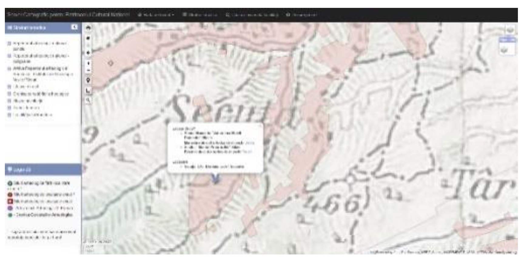
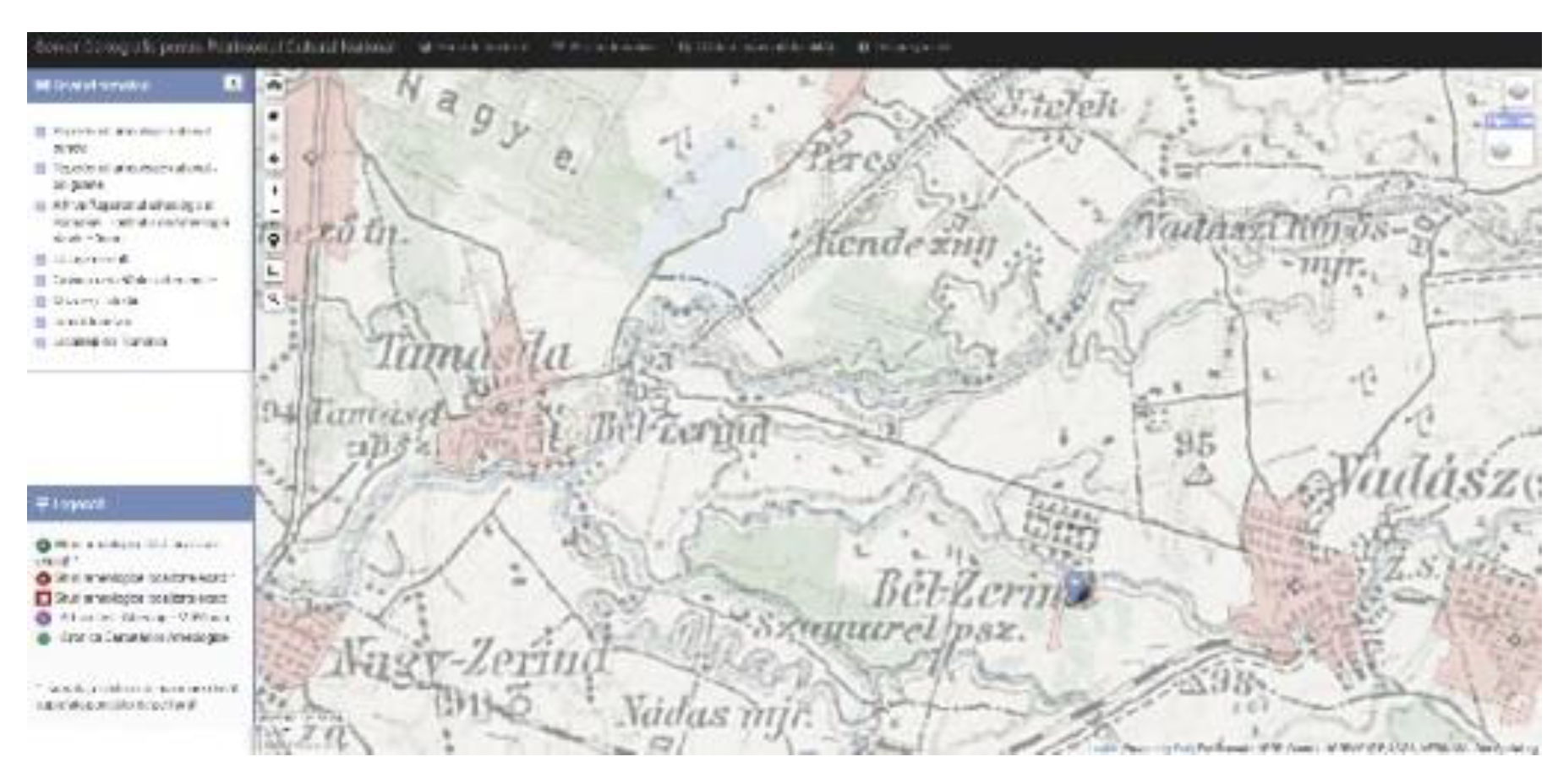
Figure 4.
[Z-AR] Zerindu/Tămasda Cimec archaeological map, the Josephine Map, 1782-8520.
BUILT [S-SV] Study case Traditional rural plots – Boroaia, Suceava county, Romania
Traditional rural plot - Historical assessment21,22
The origin of the Boroaia village name is based on the “hypothesis of transfer from Transylvania.” This hypothesis is also mentioned in the monograph of the locality, which considers it reasonably certain.23 The Banat area is remembered for the 150 families that left the village of Macea, Arad County, for Moldova, near Suceava.24 Boroaia and Sacuta are from 1772-1774, but their documentation is unavailable.
Historical, village monography reveals some dates: “Boroaia is also a prehistoric locality (...) and on the terrace of the Tîrziu stream, (...) Neolithic (Cucuteni phase A). “25 archaeological protected – near Boroaia village Tumular necropolis Daco-Roman period (3rd - 4th century)26
“Hydrological data. Săcuţa village27 / Secuta in Moldavia (1892-1898) map is related to the Romanian Seaca river (name translation as Dry, Drain), a temporary flowing river. Decreasing the scale, a family plot area, “the names of some families (...) C. family name”28,29, appears as one of them, and teacher Nicolae Cercel30 remembered this family origin is from the Banat area, Transylvania31. The plot for the first family member, named C., dated 189932, bears the same name as that of other villages in the same county, such as SV3-Brosteni, a village with inhabitants of Transylvanian origin. The same origin of the relocated inhabitants was noticed for SV7-FunduMoldovei village, SV8-Malini, where the ditches appear as plot limits a particular measure for a wetland landscape, SV9 - Paltinoasa, SV12—Stuplicani, SV15—Vatra Moldovitei, and Sv18 - Brodina de Sus.33 Banat is a known wetland that is scarce in warm periods. The family origin seems to import the know-how for managing a related confluence of the rivers with wetlands areas in rainy times of the year and scarcity in warm periods. Diches on property limits, as well as landscape management related to different plot areas, ponds, springs and fountains, vegetation near flowing water, and related temporary wetlands, are some specificities related to an extended area of one family origin.The period related to the Anthropocene was well focused on agricultural production, and these land works were significant in one year, with specific traditions and cultural immaterial heritage. In the 2000s the village was decreasing its activities through relative abandonment. The reduced maintenance of land works affected the landscape and caused landslides near the watercourse. Still, it also widened vegetation in a wilding measure that transformed the wetland areas into protected areas, a desirable post-Anthropocene regenerative design34. This evolution is also documented on GIS maps.
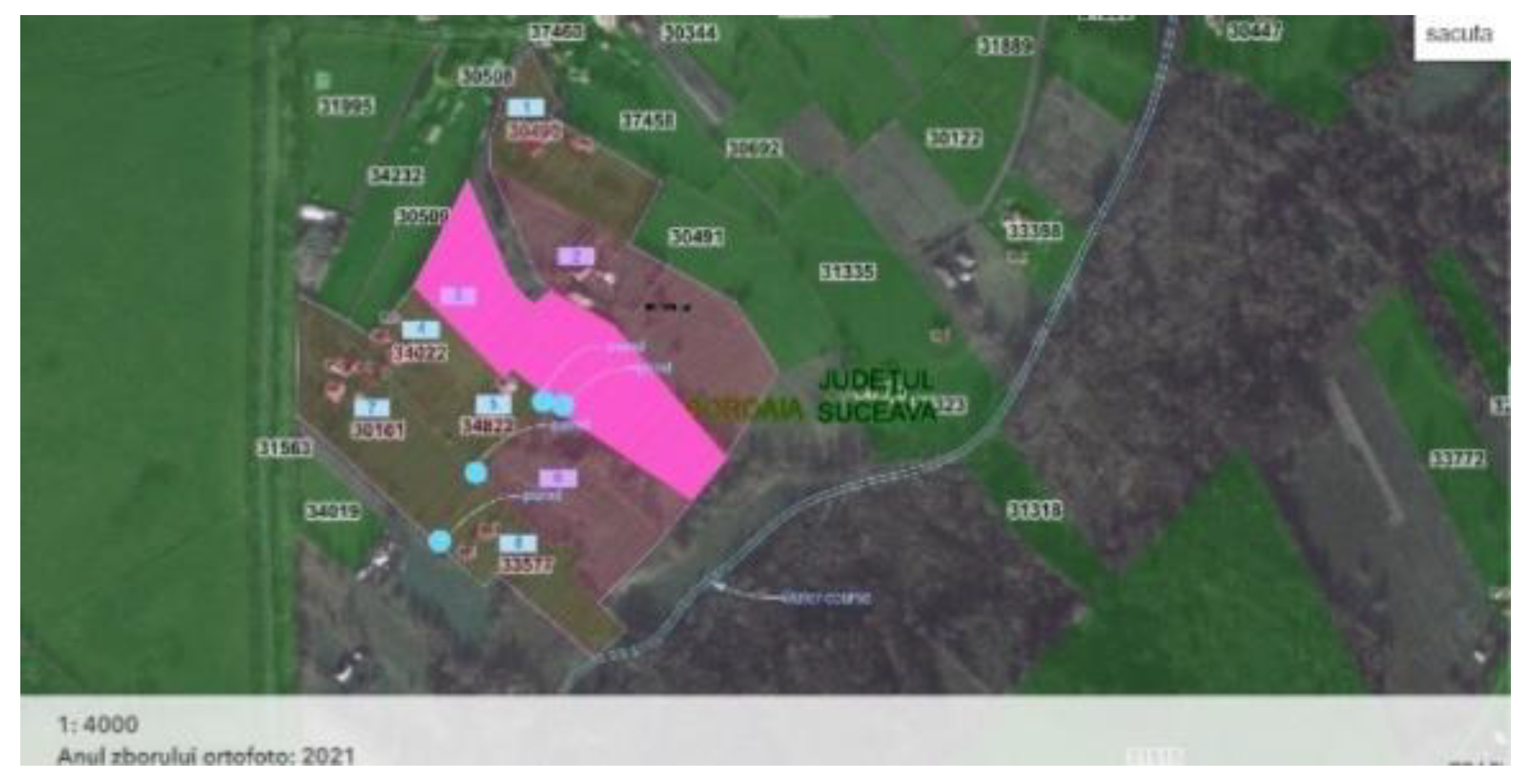
Figure 15 is on the cadastral support image ancpi/geoportal map [S-SV], with areas related to the extended family marked with numbers. Ponds are also marked to define a blue-green corridor visible on the anterior map plans (Figure 5 to Figure 9) with decreased/increased green spaces related to the year affiliated - GIs maps from 2005 till 2024. Figures 10 Sentinele 2 land cover 2017’th year and 11 Sentinele 2 land cover 2024,th year compared, land cover evolution for plot 3 No marked in the context of changed land use. If the two Sentinel 2 maps reveal a decreased green area for the entire Sacuta locality, the blue-green corridor increased can be noticed.
Figure 5.
[S-SV] 2005 year.
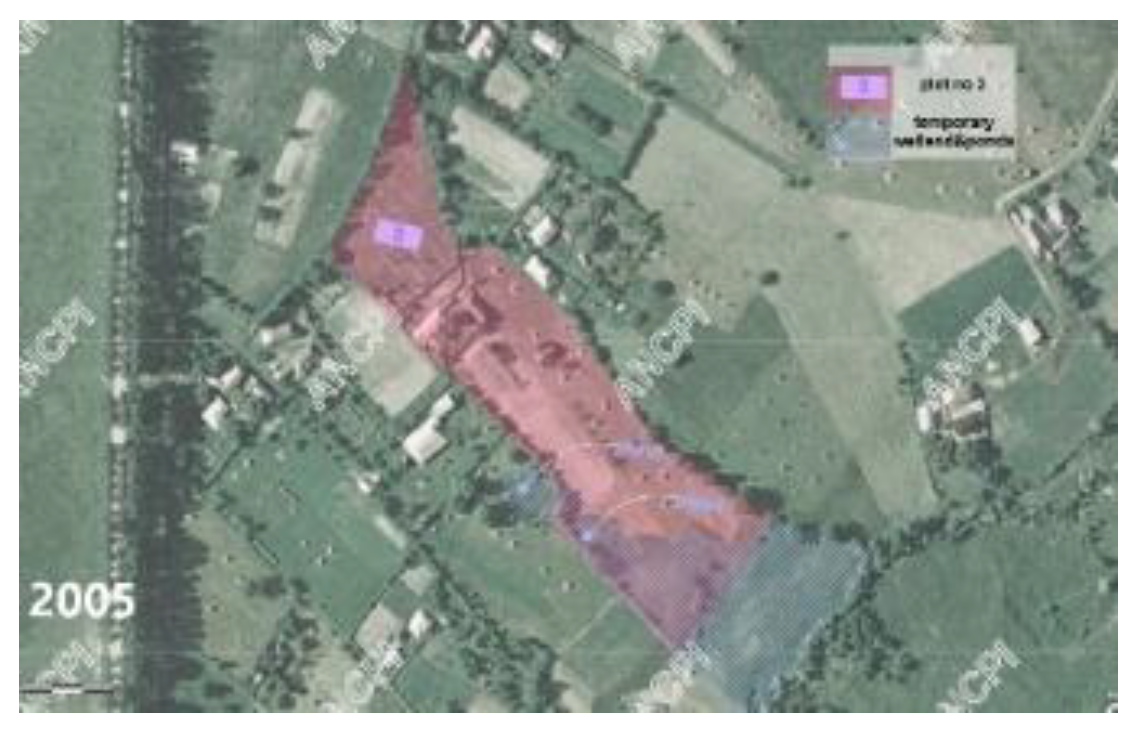
Figure 6.
Figure 6. [S-SV] 2009 year.
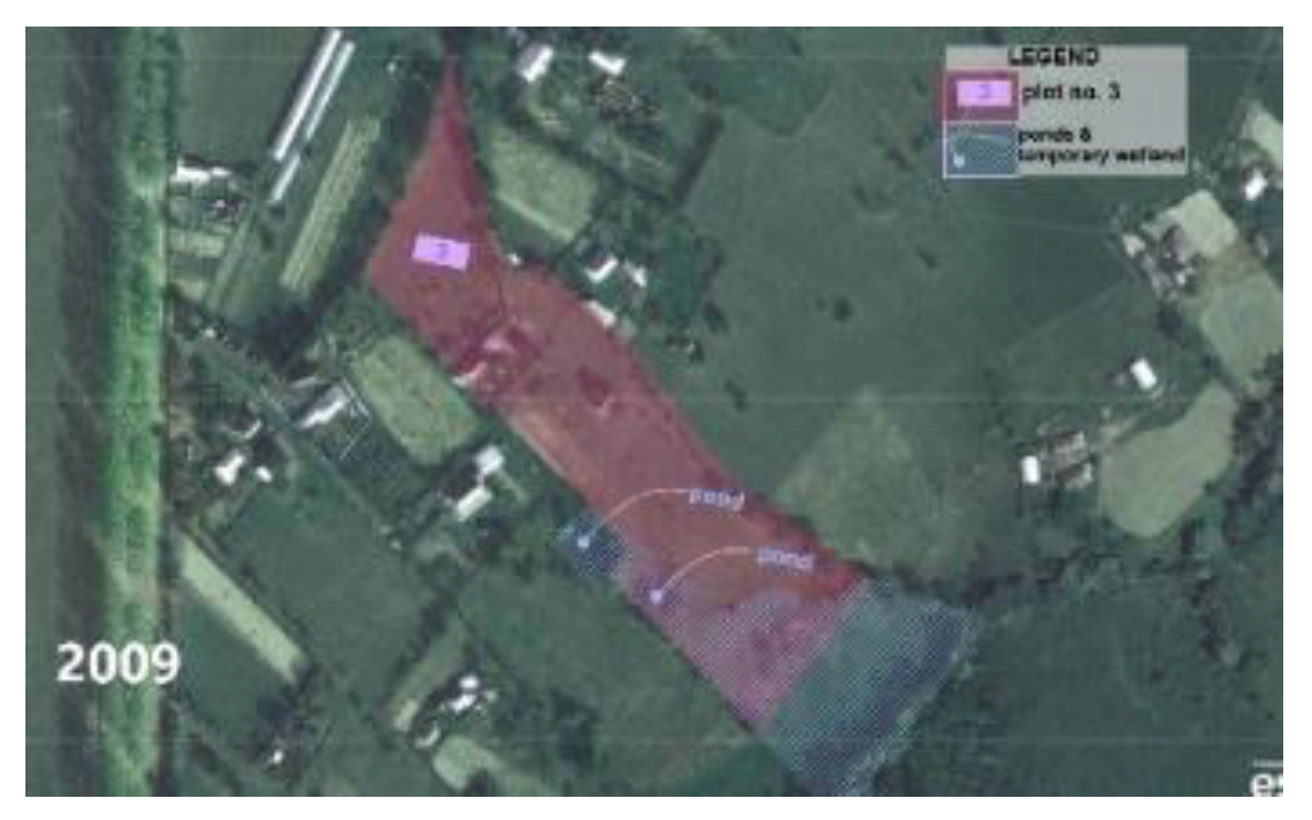
Figure 7.
[S-SV] 2012 year.
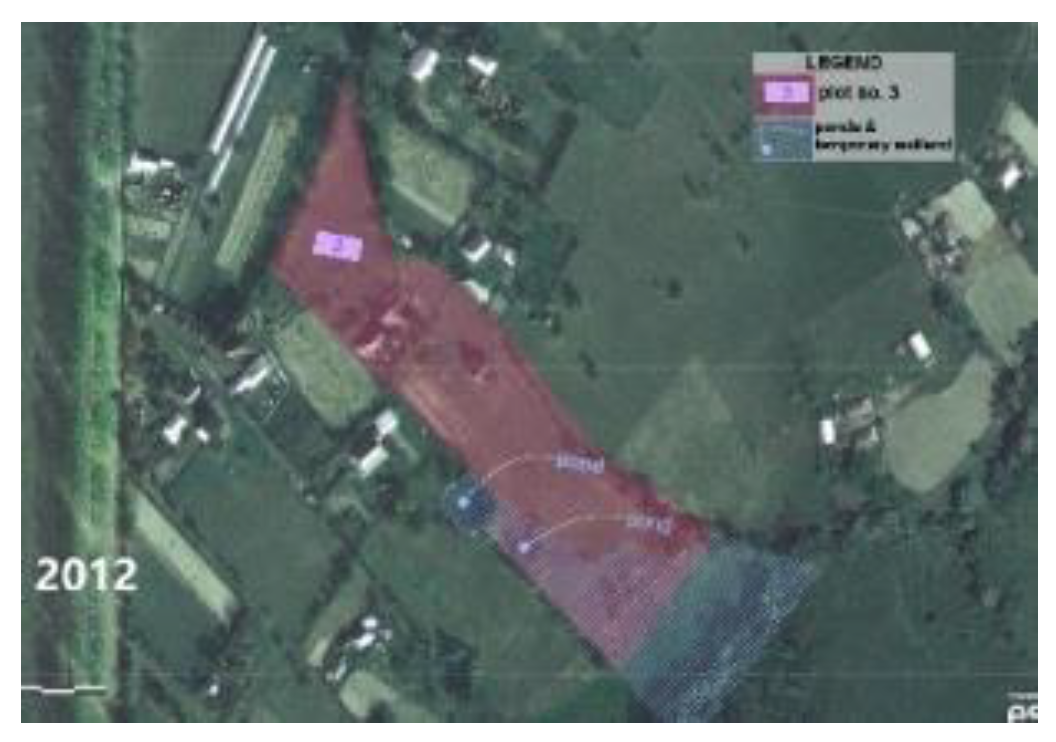
Figure 8.
[S-SV] 2017.
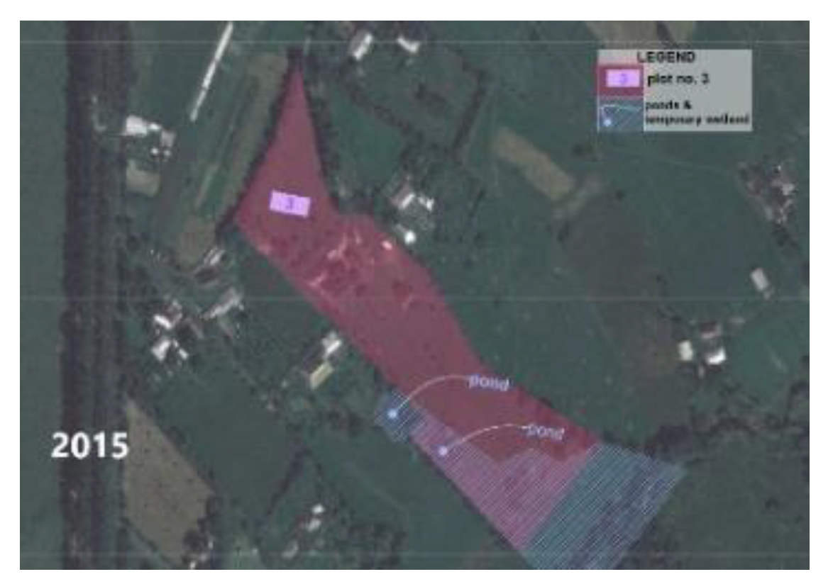
Figure 9.
[S-SV] 2024.

Figure 10.
[S-SV] Sentinele 2 land cover lot marked, Sacuta, 201735.
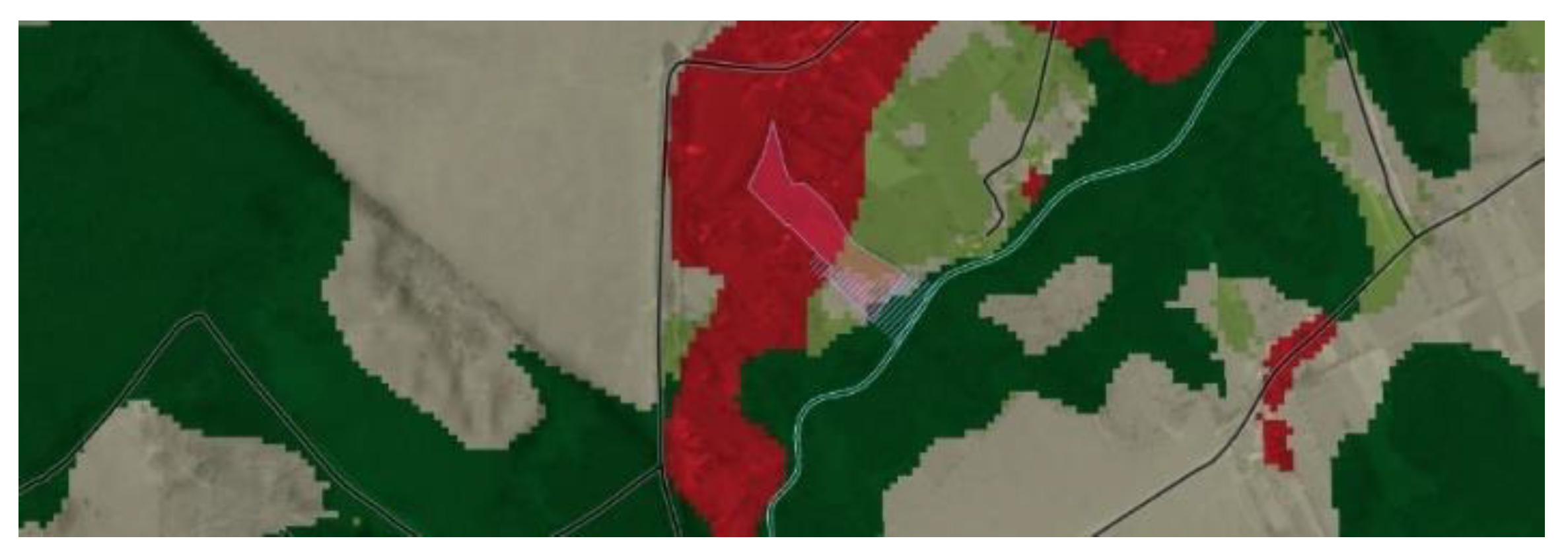
Figure 11.
[S-SV] Sentinele 2 land cover lot marked, Sacuta, 202436.
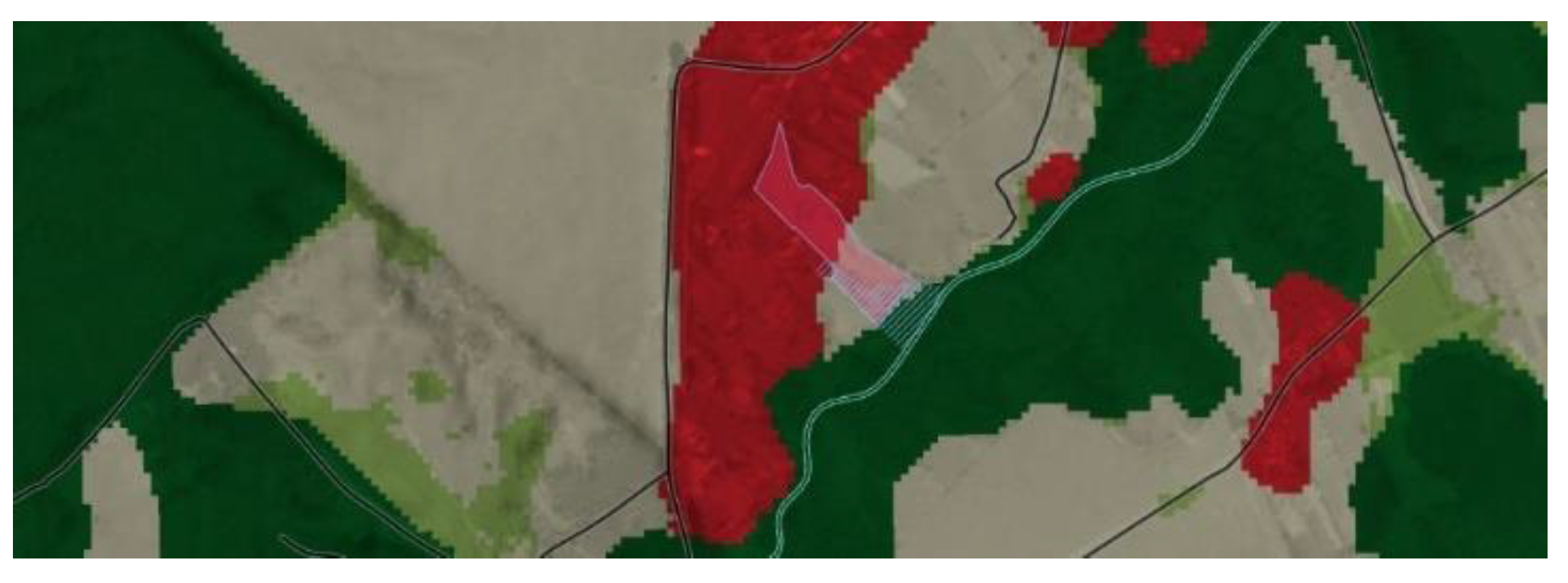
Figure 12.
[S-SV] planimetric sketch.
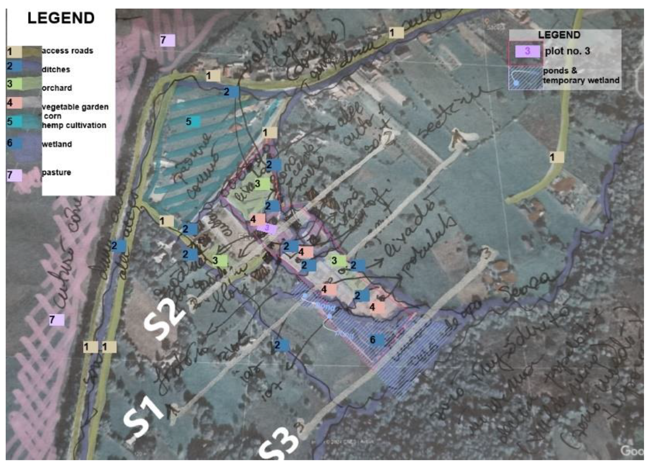
Figure 13.
[S-SV] dated photos.
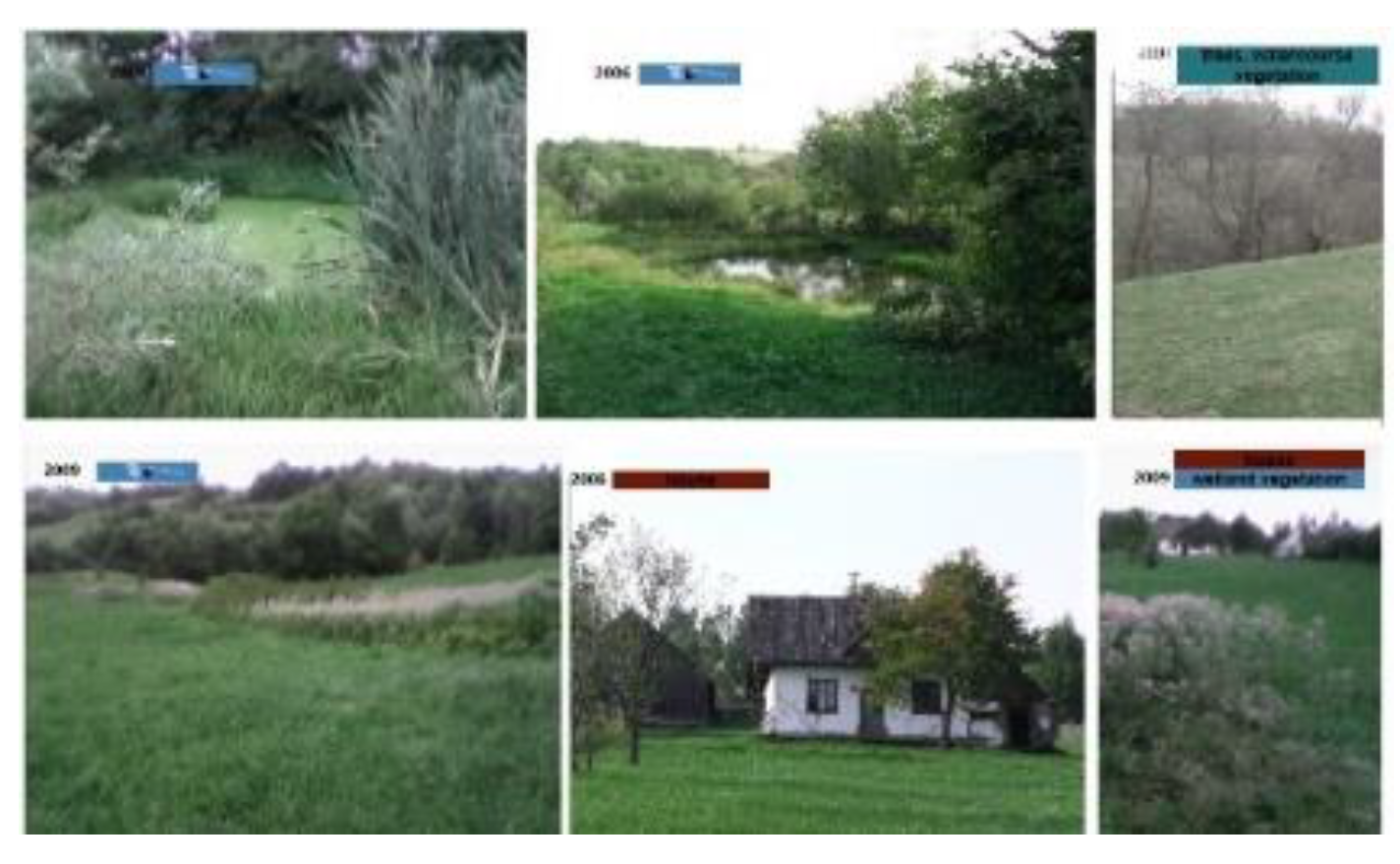
Figure 14.
[S-SV] Sections sketch with ponds and ditches, particular measures for a wetland landscape.
Figure 14.
[S-SV] Sections sketch with ponds and ditches, particular measures for a wetland landscape.
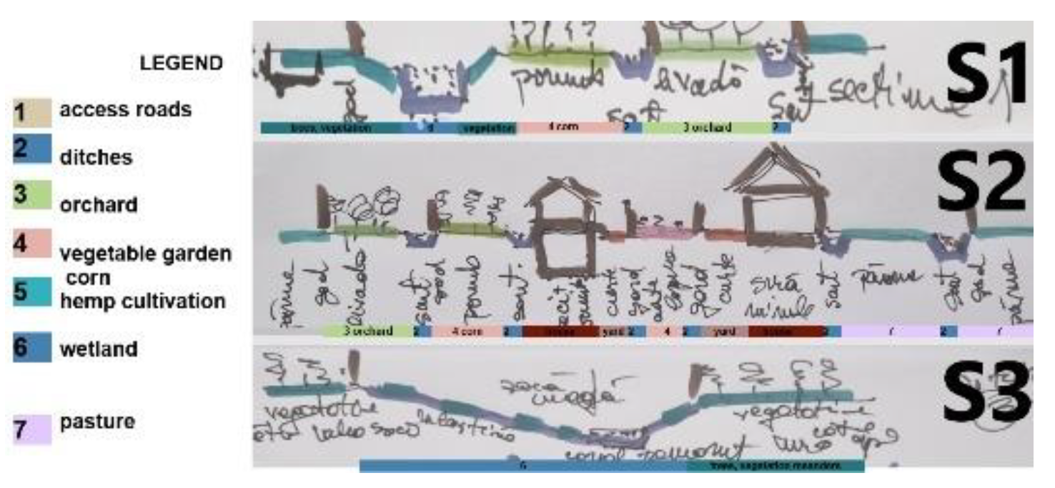
Figure 12 [S-SV] Planimetric sketch and the Figure 14 [S-SV] other sketches of the No. 3 plot, Ilie C.’s plot traditional landscaping – sketched plan, land sections, and Figure 13 [S-SV] photos of the pond and watercourse wetland area. Every part of the 3 no. The plot was situated in a family-oriented urban environment, featuring a house with a front flower garden in the yard, a vegetable garden, a beehive yard, cornfields, and pasture, all areas delimited by numerous ditches. This pond continues to be a pond set of neighbours until the watercourse, with a natural wetland for most of the year boundaried by the Seaca watercourse.
Figure 15.
[S-SV] Area related to C. name family with ponds marked blue colour - families same name & origin37 1. Gheorghe C. ; Cad. No. 30490 ; 2. Ion C.; no Cad. No. ;3. Ilie C. V. – pond & fountain; no Cad. No. ; no Cad. No.; pink color underlined; 4. Ion C.; Cad. No. 34022;5. Costache C.- pond; Cad. No. 34822; 6. Ion C.; no Cad. No. ;7. Mihai C.- pond; Cad. No. 30161;8. Gheorghe C. V. – pond; Cad. No. 33577.
BUILT [Z-AR]38 Study case Anthropocene Agricole plots - Zerind Polder, Arad County, Romania39
The TRIAD for small-scale regeneration proposes re-Naturalisation for NATURE, rehabilitation for BUILT, and solar energy production for ENERGY in the particular Romanian polder. NATURE - As wetlands by restoring the courses of the old meanders and replacing the inner dykes space in the polders as canals with wetland landscape works. Depending on how the population assimilates the new measures, smaller channels along the property boundaries are proposed to delimit areas with the same agricultural culture. Changing the culture will develop communities within the polders for ecological agriculture without pesticides, replacing them with temporary land flooding. Some agricultural plots will be agrivoltaics to achieve a proper particular for some specific cultures and renewable energy production.
Figure 1.
[Z-AR] Sentinele 2 land cover, 202440
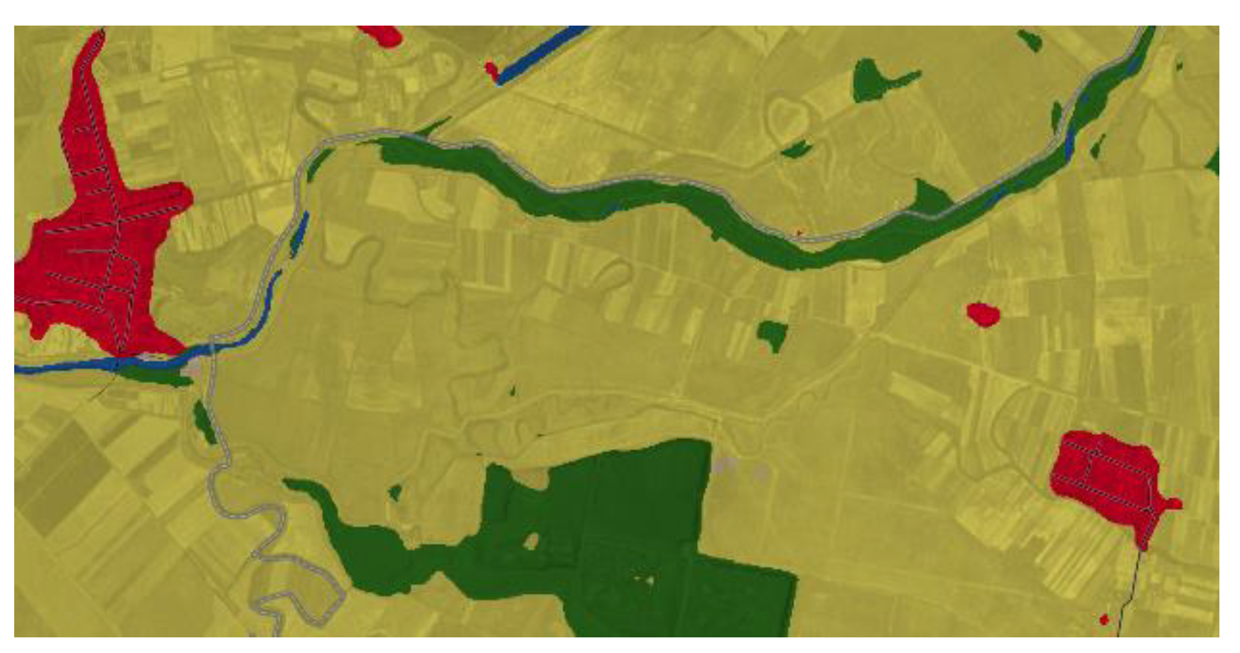
Figure 17.
[Z-AR] Old meanders needed renaturation, as noticed on the Copernicus Sentinel map41.
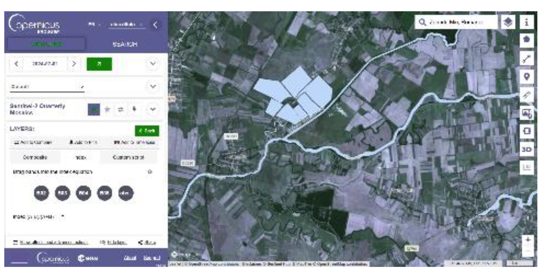
Figure 16 Sentinele 2 land cover, 2024 very similar to Sentinele 2 land cover map since 2017, and Figure 17 Copiernicus Sentinele 2 for wetland areas, where can be still noticed Old meanders needed for renaturation, with impacy in Biodiversity, Biocapacity as will be detailed NATURE Regenerative Dyad. The ENERGY areas (Figures 30) for agriculture are marked by canals on property boundaries, which will provide access to water during dry periods (Irrigation) and minimal protection against crop flooding during rainy periods, which appear as plot boundaries in the traditional wetland area landscape42. There are also well-known NBS [Nature Based Solutions] that address various challenges, from food security to natural disaster risks. Among the benefits of wetlands, we can mention the increase in Biodiversity, the expansion of carbon storage, the restoration of water reserves, protection against floods and drought, and the ecological agriculture seen in these polders. Polder’s area dates back to the 20th century, and we already admitted that the traditional family plot landscape with dikes is part of the cultural heritage of Banat wetlands areas also. 43
New NATURE [Z-AR] Regenerative Dyad “Tradition vs. Technology”
Table 9, on Biodiversity and Carbon Sequestration, is essential for a technical evaluation of different land covers. We can notice that the Wetlands area per ha unitary surface has the best Carbon sequestration/year, as an Overall vegetation + Soil. Suppose the Forest is better at vegetation Sequestration, with a value of 120 tonnes of Carbon per year. In that case, Soil sequestration puts the Wetlands in the first, best option, with a large difference: overall 686 tonnes per year compared to the overall 243 tonnes for the temperate forest.
Table 9.
Biodiversity & Carbon Sequestration 44.
| Carbon Sequestration (Tones of carbon per year) |
Boreal Forest | Temperate Forest | Temperate Grassland | Tropical Forest | Desert and semi-desert | Tundra | Wetland | Tropical Savana | Croplands |
|---|---|---|---|---|---|---|---|---|---|
| Surface (ha) | 1 | 1 | 1 | 1 | 1 | 1 | 1 | 1 | 1 |
| Vegetation Carbon Sequestration | 64 | 120 | 7 | 120 | 2 | 6 | 43 | 29 | 2 |
| Soil Carbon Sequestration | 344 | 123 | 236 | 123 | 42 | 127 | 643 | 117 | 80 |
| Overall Carbon Sequestration | 408 | 243 | 243 | 243 | 44 | 133 | 686 | 146 | 82 |
Carbon Sequestration is needed as a measure for incorporating biodiversity, as measured by Table 10 Biodiversity metrics, into any budget that assumes carbon Credits in cases where biodiversity credits are needed but not available.
The more accurate Biodiversity metrics comparative de G-res tool for dams and polders (Figure 19) is similar to those available in the United Kingdom, but not with the same level of accuracy. There appears to be a Gap in implementing local Biodiversity tools and Biodiversity credits.
Table 10.
Biodiversity metrics45 vs G-res tool biodiversity metrics46.
| Biodiversity metrics |
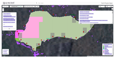 Figure 19
[Z-AR] Zeridu polder - G-res Arch. Nina Ditoiu’s image in the G-res online tool as a comparative for biodiversity land use47
Figure 19
[Z-AR] Zeridu polder - G-res Arch. Nina Ditoiu’s image in the G-res online tool as a comparative for biodiversity land use47
|
G-res tool metric |
| Cropland | Cropland | |
| Grassland | Grassland/Shrubland | |
| Heathland and shrub/ Tundra | Grassland/Shrubland | |
| Intertidal Hard Structures | Bare area | |
| Intertidal sediment | Permanent snow/Ice | |
| Lakes | Waterbodies | |
| Sparsely vegetated land | ||
| Urban | Settlements | |
| Woodland and forest | Forest | |
| Coastal Saltmarsh | Drained Peatlands | |
| Rivers | Wetland |
The Figure 3 is the concept for the polder with the relevant works proposed in a regenerative design – NATURE with Biodiversity works , ENERGY measures also noted as in Table 10:
1. Watercourse’s longitudinal connectivity with minimal interventions like fish-friendly micro hydropower; 2. polder boundary preservation of built dykes - internal polder contour channel; 3. old meander renaturation; 4. The old internal polder dike was abolished and designed as a canal with a wetland area landscape; 5. Agricultural landscape inner polder with dykes on property boundaries - specific New / ReBuild as “cultural” boundaries also as irrigation canals (Green Concrete material irrigation canals covered by translucent photovoltaic panels Energy Production & Energy Consumption through pumped water irrigation); 6. agrivoltaic properties with trees and specific culture needed solar shading- Solar PV Energy Production; 7. Fish-friendly micro hydropower as Solar PV Energy Storage & Energy Production/ Green Hydrogen Production - PV Energy Consumption;
Figure 20.
ENERGY & NATURE & BUILT48.
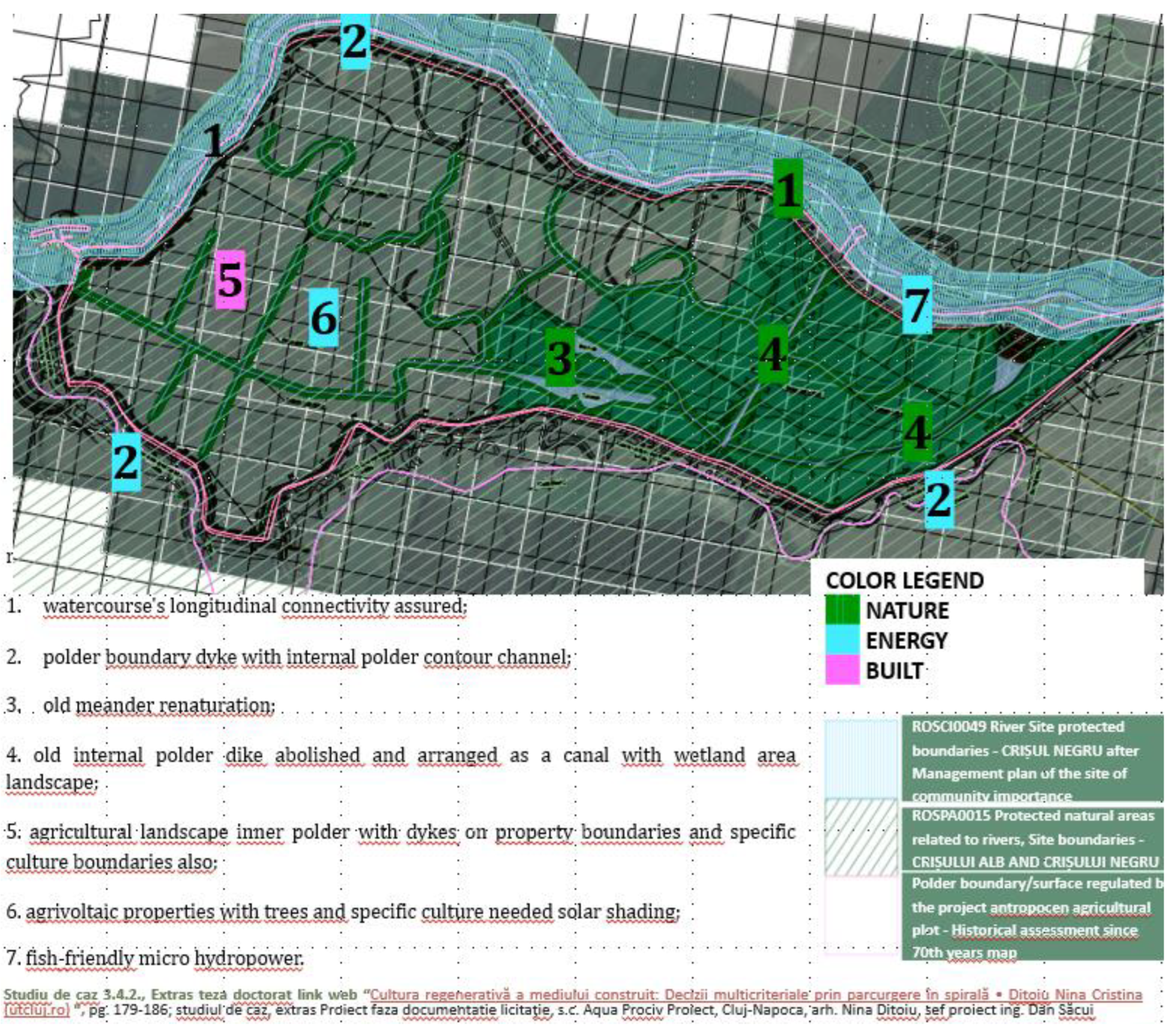
Figure 20 presents the Zerindu site plan [Z-AR], the support drawing plan with site-protected areas, such as the CRIȘUL NEGRU river and pink color line representing the polder dikes boundaries. The measures for the three dyads NATURE-ENERGY-BUILT are noted as color codes (gree, blue, pink) for increased visual visibility.
New ENERGY [Z-AR] Regenerative Dyad “Passive vs. Active” [Z-AR]
Table 10.
Energy Production / Consumption - Storage.
| PRODUCTION49 | CONSUMPTION - STORAGE50 |
| Solar Photovoltaic Energy Production Agrivoltaics Energy Production |
Solar Energy Consumption for Green Hydrogen Production Hydrogen Production as Energy Consumption |
| Green concrete material irrigation canals with translucent photovoltaic panels, covering solar PV production and consumption through pumped water irrigation. Fish-friendly Micro hydropower as Solar Energy Storage & Energy Production | |
Agrivoltaics production
During the 21st century, as Earth’s population continues to grow, the demand for food and energy is also expected to rise. To obtain food, agricultural land will become one of the most sought-after assets on the planet. The trend to generate as much renewable energy as possible will also need to continue in order to combat climate change and ensure our descendants a more sustainable and climate-neutral future. As an example, calculations by the Fraunhofer Institute for Solar Energy Systems (ISE) show that the installed PV capacity in Germany needs to increase by six to eight times by 2045 if the country’s energy system is to become climate-neutral51. The proposal to combine land areas from polders used for agriculture with renewable energy production is one way to address food and energy demand concerns.
As already presented in Table 5 for the ENERGY dyad “Passive vs. Active”, the renewable energy-related assessment identified agrivoltaics, translucent solar panels on irrigation canals, micro-hydro fish-friendly facilities, and possible smaller-scale green hydrogen production facilities as potential production sources. The expected energy consumers might be the agriculture-specific installations needed for growing the crops, like the irrigation pumps, but also the green hydrogen production facilities, if considered. Additionally, depending on the particularities of the territory or even locality scale of the land used for the polder, there can be identified also solutions for the connections to the power grid, in which case the surplus renewable energy generated into the polder might be exported into the rural power grid, while the eventual lack of energy in the polder might be imported as energy supply from the power grid. Since the PV production is variable, depending both on the location, season, time of day, shading and other variables, to ensure a certain “in-band” production capability for the polder the use of storage systems will be also necessary.
It is obvious that renewable energy requires land area, either if it is solar or wind based. Solar energy is quite land intensive – for example, for a solar plant of 1 MWp it is necessary a ground area of at least 10,000 sqm or 1 hectare (around 2.5 acres), with no shade52. Other older sources consider even larger ground areas of 4-5 acres53 or even 6-8 acres54 needed for 1 MWp, but since the efficiency of photovoltaic panels increased, the 10,000 sqm figure seems more accurate nowadays. The ground area will have to accommodate also the other elements needed to build a PV system (inverters, cables, single-axis, tracking systems, access roads, connection to the grid, etc.). The overall average direct impact area for wind parks is 0.3 ± 0.3 hectares/MW for permanent impact and 0.7 ± 0.6 hectares/MW for temporary impact, or a total direct surface area disruption of about 1.0 ± 0.7 hectares/MW55. The previously mentioned estimation is based on the fact that the entire land is used for renewable generation.
However, intensive agriculture for ensuring food safety competes for land with renewable energy sources for providing the power. Luckily, especially for solar power, colocation is possible. For combining energy and agricultural production on the same area, agrivoltaics or agri-PV has been proposed. Given climate change threats, agrivoltaics may reduce inter-annual economic outcome fluctuation due to the frost and high-temperature negative effects on crops by generating economic outcomes through energy production56. Using agrivoltaics technology can also provide some benefits for crops as it can create a specific microclimate beneath the solar panels by altering factors like air temperature, relative humidity, wind speed, wind direction and soil moisture. The panels shield crops from both excessive solar radiation and adverse weather conditions like strong rains and hail, potentially also reducing water consumption and stabilising yields during dry years. Since different crops can be grown on the same land, agrivoltaics also support Biodiversity and contribute to climate change mitigation through sustainable agricultural practices44.
Polders are land plots well suited, especially on their wetlands, for agrivoltaics. That way, polders can be beneficial not only for water management and flood defence but also for conserving Biodiversity and growing certain agricultural crops while generating renewable energy at the same time.
However, while for solar energy generated by PV panels located on land plots used only for renewable energy generation the specific values already mentioned for energy production might be around 1 MW / hectare or even less, in the case of colocation, when the same land plot is used both for agriculture by growing specific crops and for energy production, the value of MW / hectare would decrease, but even so, agrivoltaics can increase yields for some specific types of crops, like fruits and berries, by up to 16%57. Using the land within the plots in this way makes it more efficient thanks to combined electricity and food production.
Within the polders the solar panels will be placed in a way that does not affect significantly the crops - either above crops that benefit from shading, like berries (see Figure 21), or between crops to enable the use of farming machinery (see Figure 22). While in the first case, for fruits and berries, there is rather an increase in yields, in the latter case, the revenues from the sales of generated electricity compensate the reduction in crop yields.
Figure 4.
Horizontal PV panels installed for specific crops like orchards, fruits, and berries.

Figure 5.
Horizontal PV panels installed for specific crops like orchards, fruits, and berries.
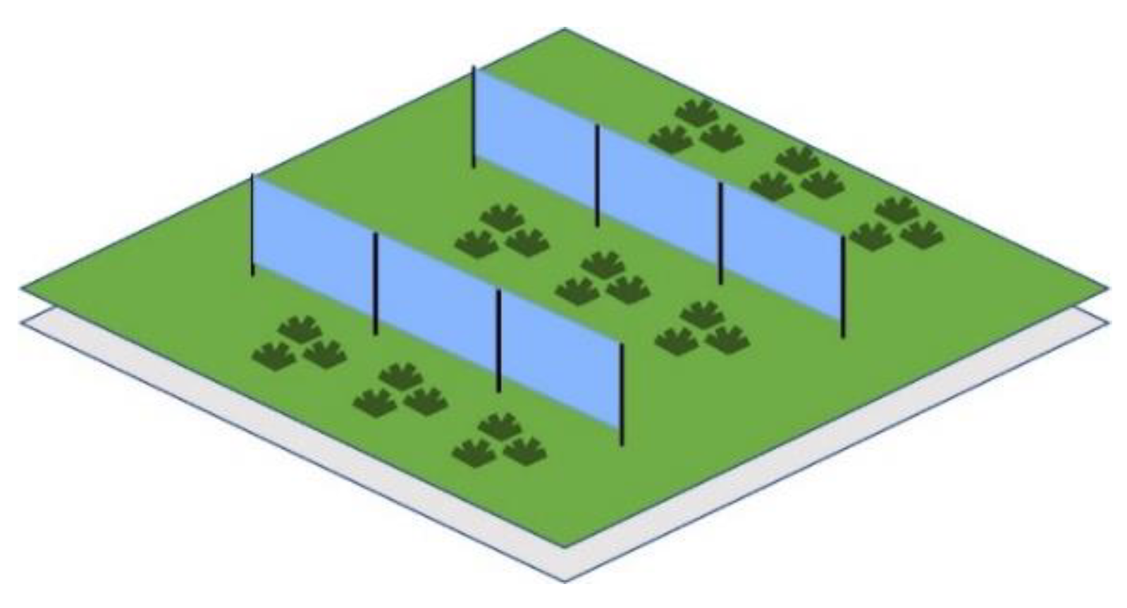
Agrivoltaic systems can range from overhead solar used especially for fruit orchards and berry plantations to interspaced vertical solar between main crops like roots, wheat or oats, in the latter case also allowing access space for farming machinery (tractors, ploughs, etc.).
In overhead agrivoltaic systems, a clearance of sufficient size (usually 2-4 m) ensures adequate space for the plants underneath. In interspaced agrivoltaic systems, row-to-row spacing can exceed 10 m to accommodate farming machinery. Sometimes, inter-spaced agrivoltaic systems might also comprise solar photovoltaic panels (PVP) installed at a certain tilt angle or even solar trackers, which vary the position of the panels in relation to the sun to optimise both electricity production and crop shading patterns, depending on the crop used.
Usually, agri-photovoltaic (APV) panels are east-west oriented, allowing their daily electricity generation profile to be quite wide compared to south-facing panels. They also exhibit higher efficiencies, even during cooler times of the day. As a result, even without energy storage added to a polder where east-west oriented APV panels are used, due to their wider generation profile such systems can be used for grid balancing easier, reducing curtailment and energy exports during the time of day when electricity prices are higher57.
Vertical PV systems, used especially for interspaced agrivoltaics, have the added benefit of fully utilising the bifacial features of modern solar panels, reaching capacity factors similar to traditional ground-mounted solar farms, despite an east-west orientation57.
While apparently colocation of solar energy and farming seems to decrease the yields in lands, studies57,58 showed that they can increase yields for specific categories of plants, depending on location and weather: crop yields for berries or fruits can increase by 15-16% under 35% shade, compared to an unshaded reference, being a perfect fit for overhead agrivoltaic systems (see Figure 23).
Figure 6.
Overhead APV effects on different crops yields, shading 35%57,58.
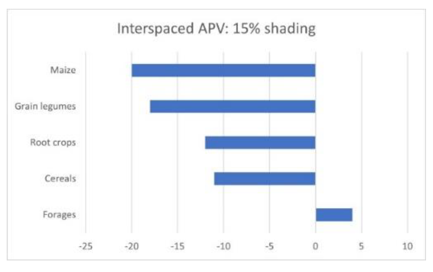
Figure 7.
Interspaced APV effects on different crop yields, shading 15%57,58.
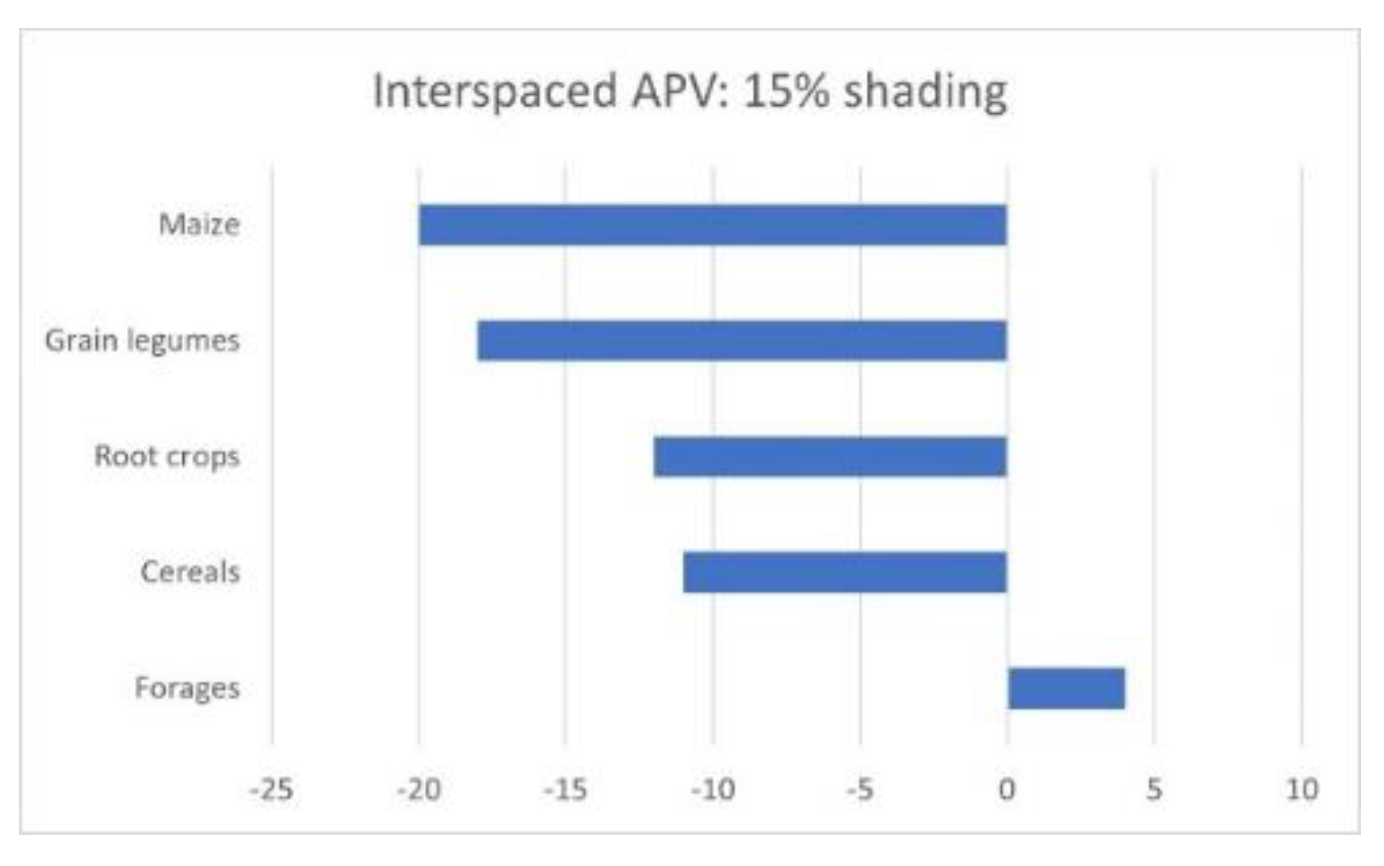
The same EMBER study57 conducted for Central European countries, using data from another research58, showed that crops such as cereals (e.g., wheat, rye, oats), maise and root vegetables, are more sensitive to shading. The study concluded that with 15% shading, cereals will decrease yield by only 11%, root crops by only 12%, and maise by over 20%. By contrary, forages (such as grasses) can actually increase by 4%. Interspaced agrivoltaic PV system row-to-row spacing of about 10 m limits the shading to between 10% and 20% and could combine all those crops, ensuring at least a level of 80% crop yields compared to a reference (see Figure 24).
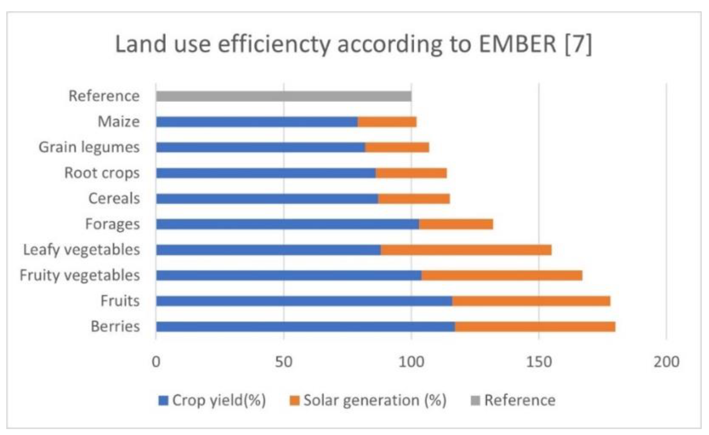
Even though the yields of different types of crops can be reduced, one significant advantage of agrivoltaic systems resides in their higher productivity, resulting from the combined production of food and electricity, meaning that the efficiency of land use is significantly increased compared to the use of land just for farming or just for producing renewable energy. Land use efficiency is measured as the sum of solar electricity generation compared to a traditional ground-mounted solar farm plus the crop yield compared to an unshaded reference57. Depending on the crop type, the results can reach 170-180% for berries, fruits and fruity vegetables and 110-130% for root vegetables, cereals and forages. Even the least shade-tolerant crop, maise, reaches 104% land use efficiency, showing that agrivoltaics will be more productive than the traditional approach of separating ground-mounted solar and farming57. A synthetic view of the land use efficiency for different types of crops is illustrated in Figure 25:
Figure 25.
Land use efficiency for different types of crops57.
Agrivoltaic solar generation varies depending on multiple parameters, including height, row spacing, tilt, geographic location, panel orientation, transparency, bifaciality ratio, and tracking. The relative generation compared to a traditional solar farm ranges from 25% for interspaced agri-PV to 63% for overhead agri-PV. The lower solar generation is predominantly because less solar capacity can be installed per hectare. Considering a capacity of 1 MW per hectare is assumed for traditional solar farms, agrivoltaic systems can achieve capacities ranging from 0.3 MW/ha to 0.7 MW/ha51, as confirmed by shading analysis performed using the AGRIPV tool59. Capacity factors were calculated during the study57 conducted in Central European countries, using the Python package for calculating renewable power potentials and time series Atlite60, assuming bifacial east-west vertical panels for interspaced agrivoltaics and 15 degrees tilted east-west for the overhead system.
The EMBER study57 also showed that the capital expenditure (CAPEX) for agrivoltaic projects is significantly higher than for traditional ground-mounted solar farms due to the particularities of the mounting system. An estimate of the levelized cost of electricity (LCoE) over twenty years shows that overhead agrivoltaics (with clearance heights of 2.1/2.5 to 4 m) can be approximately 40% more expensive than ground-mounted PV systems. In contrast, for interspaced agrivoltaics, this increase is only about 11%. However, both agrivoltaic systems are considerably cheaper (40-50%) than rooftop solar used in regular households or industrial projects.
Romania shares many similarities with countries in Central Europe regarding the specificities of agrivoltaics, which are intended to avoid energy demand competing with food demand for land use. Even if it was not considered in the EMBER57 document, other research papers have studied the agrivoltaic potential of the country. One such example61 is analysing a case study for a land plot of approximately 16.2 hectares located in southeastern Romania, used for cereal production (mainly wheat), with an average productivity of 2.74 t/ha/year. The region is known for its flatness, and the land plot that was analysed also has a maximum slope of 2 degrees, making the installation of PV mounting structures easier and less expensive.
The scenarios analysed were one in which bifacial monocrystalline PV modules adding up to 8.58 MWp were considered to be installed vertically in the interspaced APV configuration, a second one in which the panels were installed in the overhead APV configuration on a fixed mounting structure at a 30-degree tilt angle, calculated so that the modules wouldn’t shade the crops over a certain period, adding up to 13.2 MWp and the reference scenario was considered for conventional PVP with a 30-degree tilt, adding up to 23.1 MWp. Based on the quotations received from the local market, the research61 showed that an average specific cost for developing the project was around 850 EUR/kWp for the conventional PVP scenario, 950 EUR/kWp for the interspaced APV scenario and 1,300 EUR/kWp for the overhead APV scenario, figures which are roughly quite similar to the ones mentioned in the EMBER57 study. The research61 performed a technic-economic analysis based on the Net Present Value (NPV), the Internal Rate of Return (IRR), the Simple Payback Period (SPV) and the Benefit-Cost Analysis. The analysis has been performed for a 25-year lifetime of the investment and used input data such as the discount rate (14%/year), the export electricity price (considered for Romania as 90 EUR/MWh, taking all relevant markets into account, such as the Day Ahead, Intra Day and the Balancing Market) with a specific escalation rate (7.5% / year), the wheat price (330 EUR / ton) and its escalation rate (2.5% / year). A fourth scenario has been considered in the analysis (BAU or Business As Usual) for exploiting the land only for agricultural purposes. Table 11 shows some of the results of the study61:
| Scenario | NPV {EURO) |
IRR (%/year) |
SPP (years) |
BCA (-) |
|---|---|---|---|---|
| BAU | 23,327 | 37 | 4.38 | 1.25 |
| Interspaced APV | 1,914,339 | 17 | 8.38 | 1.22 |
| Overhead APV | 4,632,501 | 17 | 8.20 | 1.26 |
| Conventional PVP | 18,287,612 | 23 | 6.12 | 1.86 |
According to these findings, for specific input data which are also dependent on local market conditions, the NPV, IRR and SPP values for a conventional PVP project are significantly better than for the two agrivoltaic scenarios, while between the two agrivoltaics scenarios, the overhead APV one provides better values than the interspaced APV one. The conclusion is that a conventional PVP project will be more profitable than an APV project. However, since agricultural land is essential for ensuring food safety, to preserve the agricultural function of the land legislators should act in the sense to limit the use of land only for energy production, or to encourage through incentives the use of agrivoltaics systems to generate both food and electricity, or to use both approaches simultaneously. A more focused approach might be to enable agricultural companies or agricultural cooperatives to have access to financing toward implementing agrivoltaic projects from which those companies might benefit directly for the needs of growing their crops (like Irrigation, running electric farming types of machinery, different processing stages requiring power, etc.). The previously mentioned Romanian research paper61 estimated, depending on location and crop type, an average need of 4,260 m3 of water for each hectare of arable land required for Irrigation, which implies a demand of around 1.2 MWh/ha/year for electricity needed for water extraction and pumping. At the same time, if using electric farming machinery, their need for power consumption might also be ensured by the renewable energy produced on-site if properly configured. If the grown crop is wheat, the arable land would need a minimum of three farming machinery passes per year61 – the first for preparing the soil for seeding, the second for seeding and the final for harvesting the crop. Considering that the farming machinery are electric vehicles (e.g., tractors, ploughs, combine harvesters, etc.) and their power consumption might be around 80 kWh/km, respectively around 0.8 kWh/ha/pass, this adds up to a power consumption of only 2.4 kWh/ha/year12 for the farming machinery. Even if considering it an order of magnitude more significant, the value (0,024 MWh/ha/year) remains still small compared to the power needed for Irrigation (1.2 MWh/ha/year), adding to a total of 1.224 MWh/ha/year. Since the interspaced APV configuration analysed in the mentioned paper61 has been estimated at an energy production of around 9,732 MWh/year (using PVSyst), it can be seen that even this less efficient configuration does ensure a power production capability to provide power for several thousands of hectares of agricultural land.
In Romania, the installed capacities in PVP are intended to be increased by 3,665.84 MW in the near future61,62. Considering the required land mass for 1 MWp conventional PVP as 1 hectare, the increase in capacity will need at least 3,666 ha of land. Romania has a good solar potential for developing PVP projects, with solar irradiance values ranging between 1,000 to even more than 1,350 kWh/m2/year61, depending on the location. However, the agricultural potential of Romania overlaps in many areas with the solar potential map, meaning that the most profitable solar parks will have to compete with land plots with significant agricultural production capacities.
Polders are land plots which are usually considered for water defence and management purposes, where conventional PVP are not suitable to be installed, because some areas can be intentionally or non-intentionally flooded, so in this case the fact that both APV solutions are less profitable than conventional PVP configuration is less relevant. As a result, the idea to use agrivoltaics for such zones which otherwise wouldn’t be used at all for solar production allows a very constructive coexistence between energy production and agriculture for those plots, even if the capacity factors are significantly smaller, depending on the selected APV system, compared to conventional PV systems. Obviously, since portions of the land in polders are intentionally flooded sometimes, the APV system which best suits such land plots is the overhead APV.
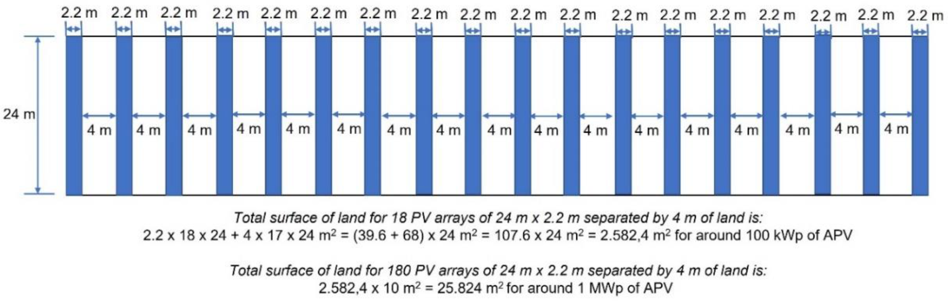
For polders, where the land can be used both for Biodiversity and agricultural production plus energy production through agrivoltaics, this research considered the simulation of around 1 MWp overhead APV system installed on the plot by using 180 rows of around 24 m length resulting in a total of 1,800 bifacial solar panels of 560 Wp (having a bi-faciality factor of around 80%), installed at 2.2 meters above the crop using a light structure to pose less shade on the crop. This configuration results in a land plot use in Figure 26 of 25.824 m2 for about 1 MWp, or roughly around 2,5 ha for 1 MWp, which is significantly higher than the land use for traditional PV systems (1 ha for 1 MWp), meaning that the overhead APV land use for energy production is about 40% compared to the land use for energy production of a traditional PV system. The necessary land surface has been determined according to the example shown in Annex 4 of the French Government Instruction technique DGPE/SDPE/2025-93 regarding “Application of the regulatory provisions relating to ground-based photovoltaic and agrivoltaic installations in natural, agricultural and forest areas”63.
Figure 26.
Land plot surface used for overhead APV.
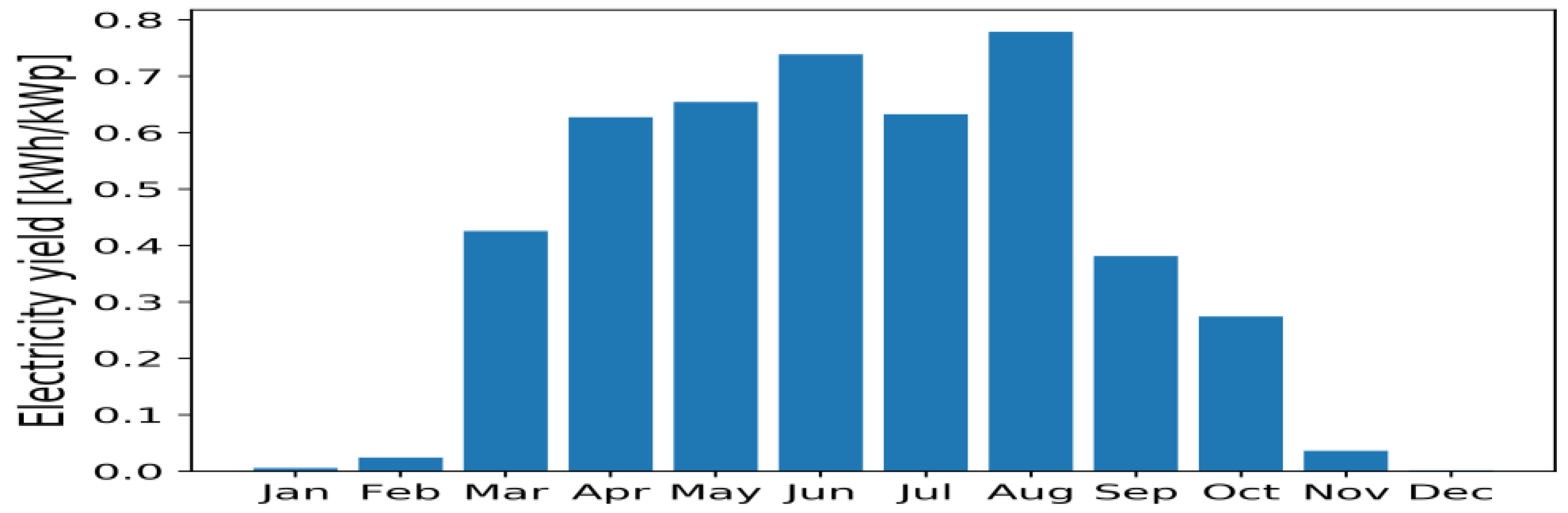
The proposed APV system orientation is east-west, and the tilt angle is 15 degrees, while the module transparency is 40%. The behaviour of the APV system has been simulated using the web tool59 developed by the KU Leuven University from Belgium as part of a Horizon 2020 project (however, considering a system ten times smaller, with only 18 rows of overhead APV panels instead of 180 rows, due to simulation limitations). The specific energy yield resulting from the simulation is 3.98 kWh/kWp/year, while the monthly distribution of produced energy is shown in Figure 27.
Figure 27.
Monthly distribution of specific solar yield in the polder59.
According to the simulation tool’s notes, it uses the weather data input based on Typical Meteorological Year data format (TMY) collected from PVGIS (2006-2016)64, the albedo of the field is fixed at 0.3, the tracking angles are limited from -50° to +50° and a backtracking algorithm is active to minimise row-to-row shading, the crop simulations are based on relative crop yield curves58 and only the shade caused by the PV modules is simulated in detail. For the shade caused by the support structure, the tool uses fixed parameters.
The remaining PAR percentage represents how much Photosynthetically Active Radiation (PAR) still reaches the crops on average compared to a reference area without agrivoltaics – this value has been estimated by the web tool to be around 97%.
In the context of growing berries on the land plot considered in the polder, the relative crop yield (compared to a reference land without solar) is shown in Figure 28:
Figure 28.
Relative crop yield vs remaining PAR in the polder59 for berries and fruits.
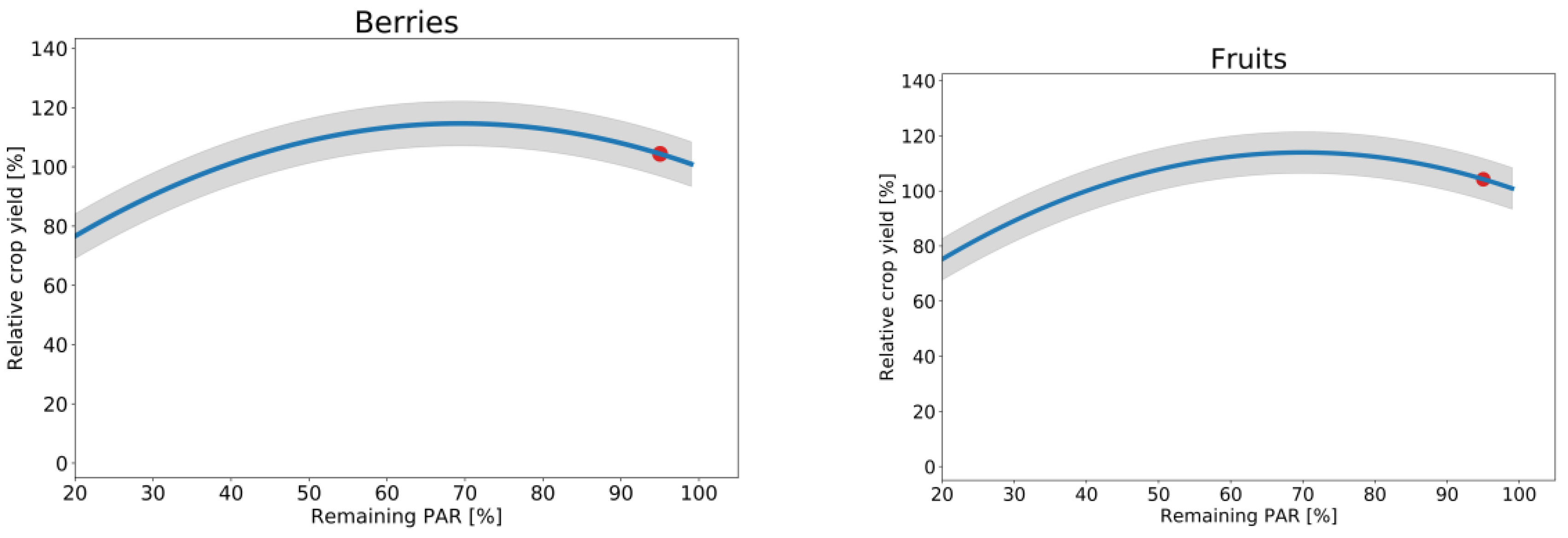
It is worth mentioning that for the calculated remaining PAR of 97%, the relative crop yield is 104%, meaning that in the presence of overhead APC, for specific crops like berries, the yield is greater than in the absence of shading from the overhead APC, making crops like berries suitable for being grown in the polder. A similar simulation shows that for fruit orchards, the relative crop yield at a remaining PAR of 97% remains at 104%, identical to that of berries.
Since the relative crop yields are significantly lower for root crops, the access of farming machinery on wetlands as the ones in the polders is more difficult due to the nature of the soil and the interspaced APV systems would be prone to flooding, in the polders the growability of root vegetables has been considered less suitable than berries or fruit orchards, which can be more easily grown on lands with collocated overhead APV systems whose structures makes them less prone to flooding. For berry and fruit orchards, the power consumption of any specific machinery used inside the polders will be negligible compared to the power produced, meaning that the energy generated in the polders will be usable mainly for Irrigation. Since the polders do usually have enough space to extend the overhead APV systems, the installed peak power might be expanded significantly to approach also other possible energy-intensive applications like small-scale green hydrogen electrolysis using water taken from the river near the polders, if the prerequisite conditions for water use and consumption might be met. If the local grid conditions allow, the overhead APV systems to be used together with berries or fruit production on the same land plot might also be connected to the grid, serving local communities or exporting the surplus power further into the grid.
Photovoltaic covering irrigation canals
Originally developed to address water loss in agricultural regions, the panels covering irrigation canals evolved into canal-covering technologies in the late Anthropocene. The technology is adapted for areas with extensive irrigation networks, mainly where traditional water management systems require modernisation without complete reconstruction, and for aquatic biodiversity, translucent photovoltaics were chosen. Agricultural communities, such as those in polders, became Energetic & Agricultural communities. This can also introduce unique, adapted design modalities that better fit local farming practices and/or traditional irrigation patterns. Semi-transparent photovoltaic panels, designed for covering irrigation canals, are recommended in arid areas, as [Z-AR], but are not for sure recommended for covering meanders re-naturated to increase Biodiversity.
Implementing translucent solar panels is transforming water management in agriculture while generating green Energy. These panels reduce water evaporation from covered canals, thereby conserving water in agricultural regions that are vulnerable to severe drought. Reduced evaporation and algae growth in the covered canals have improved water quality. The electricity generated supports the local farming community, which becomes an energy community while maintaining traditional farming practices that a family can implement on a specific rural plot of indigene traditional landscape design. At the same time, as will be noticed in Figure 30 with a replicability study in Tămaşda polder, Bihor county, NATURE area for BIODIVERSITY is not similar to the ENERGY area, where this kind of covered irrigation channels appears.
Solar storage potential
Solar storage could include green hydrogen production and fish-friendly micro hydropower, but a more detailed technical design is needed to be implemented in a future design proposal.
The Dyad related to ENERGY may examine various approaches to solar energy storage in agricultural settings, as in Figure 30. A fish-friendly microhydro power plant associated with a lateral dam or water reserve area near the water course could be considered for one of the two discussed polders. However, this research stage analyzes the possible and desirable aspects without detailing technical solutions, focusing solely on the potential for green hydrogen production and the potential of fish-friendly micro-hydropower systems. The study includes more a list than lists and technical specifications. It analyzes the potential, rather than the feasibility, of green hydrogen production for the implementation of fish-friendly micro-hydropower systems, without detailing technical solutions or specifications for different storage methods.
Figure 29 is concept sketche the study case [Z-AR] Zerindu polder, Arad county and the related replicability case study - Tămasda polder, Bihor county with measures noted, both on Crisu Negru river.
Figure 29.
[Z-AR] sketch, replicability case study - Tămasda polder, Bihor county & Study case - Zerindu polder, Arad county: planimetric sketch, Polders Zerind & Tămaşda Sketch65, the two polders with solving related to the legend. 1. watercourse; 2. polder boundary dike with inner polder contour channel; 3. old rehabilitated canal; 4. old pier inside the polder dismantled and arranged as a canal/wetland; 5—inland agricultural land for polders 6. Biodiversity /water level digitalization.
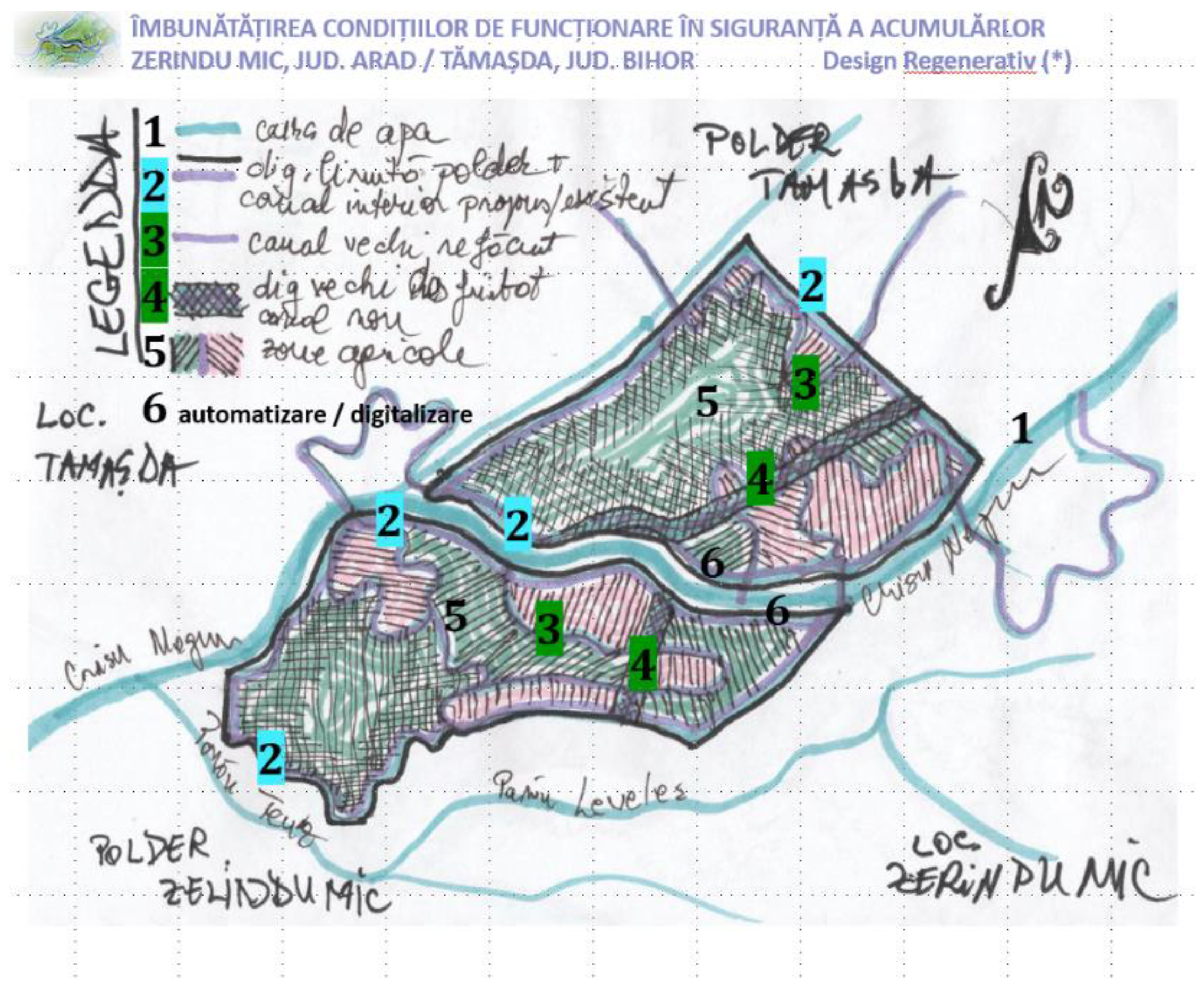
Figure 30.
Replicability study case - Tămasda polder, Bihor county, and study case – [Z-AR] Zerindu polder, Arad county, with the same proposed measures:.
Figure 30.
Replicability study case - Tămasda polder, Bihor county, and study case – [Z-AR] Zerindu polder, Arad county, with the same proposed measures:.
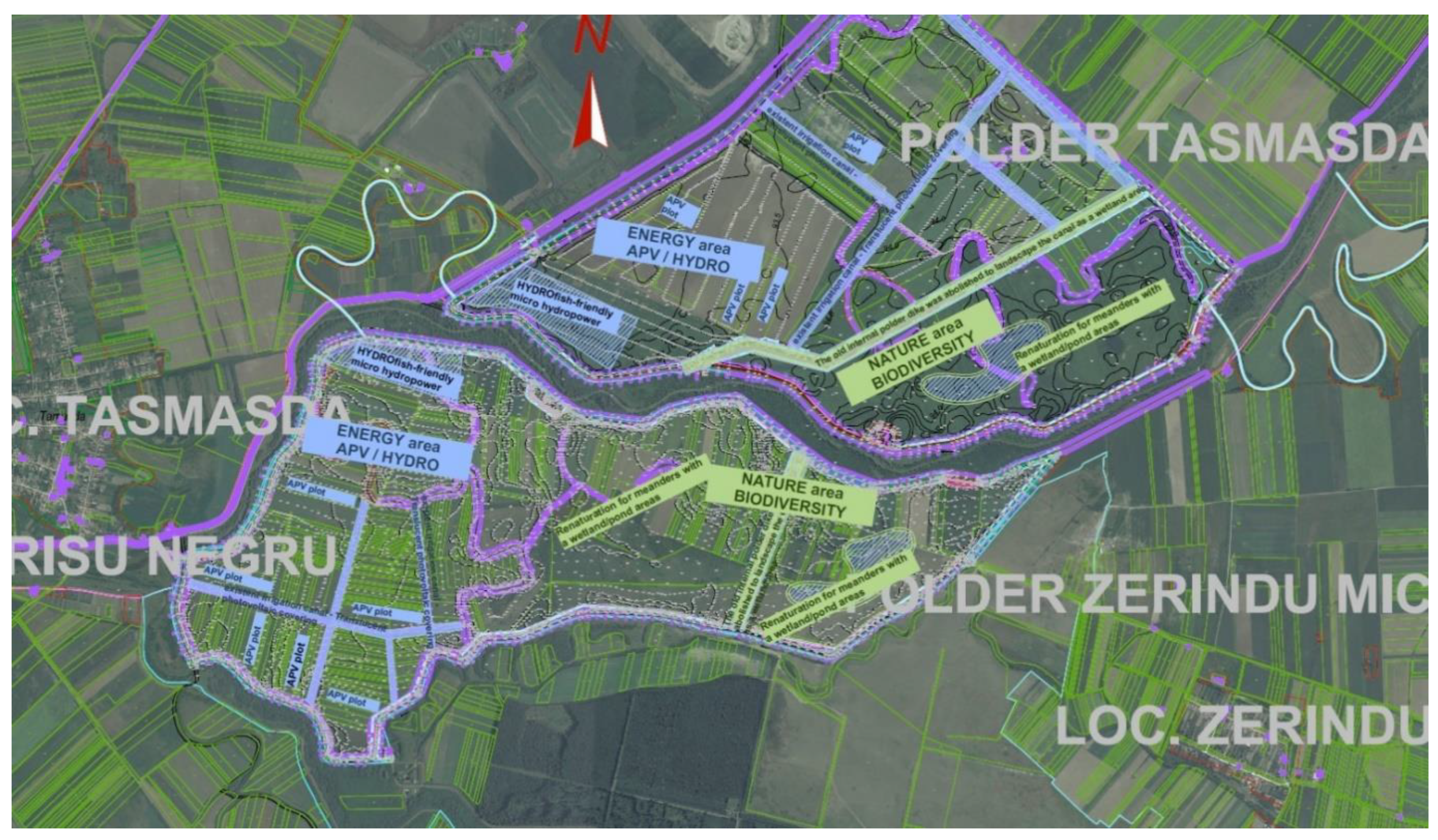
- ENERGY AREA: APV plots, fish-friendly micro-hydropower, and existing irrigation canal—transparent photovoltaic covering;
- NATURE AREA: Renaturation for meanders with wetland/pond areas. The old internal polder dike was removed to transform the canal into a wetland area
Conclusion
The practical main findings on integrating traditional agricultural approaches with modern renewable energy systems primarily focus on the case studies of traditional residential plot [S-SV] Boroaia, Suceava county and the related agrarian plots in Polderul Zerindu Mic, Arad county [Z-AR], with a replicability in Tămaşda older, Bihor county. The gaps that need to be closed relate to the Dyads involving Solar Regeneration Monad, the holistic design and the Humanistic versus Technical approach.
Table 12.
Evaluation with a similar SWOT method.
| Strengths | Weaknesses |
|---|---|
Technical:
P. Kindel’s biomorphic urbanism principles in design69 Circular metabolism’s70 implementation with Carlos Tapias’s humanist measures71 |
Technical: Weaknesses EU Taxonomy hydropower restrictions. Failure to capitalise on existing opportunities related to NbS, Biodiversity, cultural landscape, green wave, and energy transition72. Lack of studies on agricultural registry 73 Humanist: Christopher Alexxander’s ”Order as Mechanism”: „It is almost impossible to view a Mozart symphony as a machine wihich has certain kinds of behavior”. 74 Lack of Aristide Athanassiadis’s circular metabolism75 implementation with Carlos Tapias’s humanist measures76 lack of „circularity strategies (...) formulated and implemented” 77 |
| Opportunities | Threats |
|
Technical: Blue-green corridor development promotes native species and increases biocapacity78, Biodiversity, Human Well-being, Wildlife Corridors part of Green Infrastructure79. Digitalisation is necessary to develop energy grids that incorporate renewable energy production and achieve balance through storage and dam management. Assessment of green hydrogen production. Photovoltaic energy production Agrivoltaics. Hydropower production environmental impact technologies - fish-friendly turbines micro hydropower80; Relevant cultural heritage elements of the wider area and specific enhancement measures. Relevant contribution to the “green wave” measures and energy transition81,82. Humanist: “Beauty Project: A maniffesto”83, „Pretty is never enough. Useful is never enough. (...) Design can create beauty for everyone, ebverywhere.” David Seamon’s Place-Making Opportunity „The invention of the rivers” as „Waters of Eden” after a „River colonialism” 84 |
Technical: Financing issues. Timely synchronisation of measures among all involved actors. The environmental impact of potential applications, including photovoltaics, hydropower, and hydrogen production, must be assessed. Population options about Development of Agricol / Energetical Communities Humanist: M. Heidegger’s standing - reserved form, related to technology implementation after a “very insistent asking for delivery” 85,86 vs Neil Leach’s “sacrifice as a form of vitalisation” 87 “Beauty Project: A maniffesto”88, „We like what we know” Threats in Identity versus Sustainability89 David Seamon’s Place-Making and relevance of ”place identity’90 |
| Discussions | |
| The need for a balance between Technical and Humanistic perspectives and between Energy and Nature is crucial. This discussion highlights the differences in the interdisciplinary authors’ team. The necessity for precise measurements, such as accurate figures in energy production or budgeting, and the importance of preserving Biodiversity, which can be accounted for through biodiversity credits or carbon credits as part of the same budget. Additionally, the topic encompasses the concept of double materiality, a widely discussed concept internationally. Understanding the reasons that drive the need for a taxonomy with environmental DNSH principles, the Knowledge vs Understanding spiral that expands and contracts scales and metrics in Nature, Energy, and Built environments, involving relevant multidisciplinary experts, is about conquering Understanding through multidisciplinary Knowledge. There is no single best option. It’s about making compromises, rechecking, and reviewing the spiral as often as necessary. | |
The fundamental relationships explored in the dyads are Technology vs Tradition (Nature), Technical vs Humanistic (Built), and Active vs. Passive (Energy). Each Dyad can effectively combine traditional Knowledge and modern technological solutions to create sustainable and culturally appropriate systems. In conclusion, a similar SWOT (Strengths, Weaknesses, Opportunities, Threats) analysis assesses the technical and humanistic aspects of the studied systems. The technical strengths identified include successfully integrating agrivoltaic systems with traditional agricultural practices and efficient water management through modernised older systems. The technical weaknesses focus on the higher initial costs and the complexity of implementing hybrid systems.
On the humanistic side, strengths include preserving cultural landscapes and traditional agricultural Knowledge, while weaknesses include potential resistance to change from local communities. Opportunities highlighted in the SWOT analysis include the potential for extending these hybrid approaches to other regions and the possibility of developing new technological solutions that better integrate with traditional practices. Threats are examined from both technical and humanistic perspectives (such as the impact of climate change and the loss of indigenous Knowledge). The research presents a comprehensive overview of a global study examining small-scale solar energy for energy production as a sine qua non principle after DNSH (Table 2).
The primary conclusion pertains to cultural traditions and local approaches that can inform energy solutions and technologies. The study explicitly examines agrovoltaics and the integration of solar energy into traditional agricultural practices. A case study of a polder (hydro-technical work, temporary non-permanent dam limited by dikes) is presented, demonstrating how environmental challenges, risk management and the transition to renewable Energy can be addressed while preserving a cultural landscape - an Anthropocene polder through a vernacular traditional similar family plot landscape design. The research highlights the importance of traditionally inspired design in relation to historically studied ethnographic support, underscoring the need to balance technical and humanistic approaches, as well as the importance of Energy & Nature principles after DNSH.
Acknowledgements
The case studies related to this research, including the Renaturation of Zerind Polder, Arad County, and the replicable case study of Tămasda Polder, Bihor County, were conducted by the Aquaprociv Proiect company in Cluj-Napoca, Romania, and underscore the significant relevance of the Aquaprociv Proiect team’s specific research on design.91
Acronyms
| [DNSH] | Do No Significant Harm; |
| [NBS] | Nature Based Solutions; |
| [S-SV] | Săcuţa locality, Boroaia, Suceava county, Romania; lat. 47313130o N, long. 26283486o E, +423m ; |
| [Z-AR] | Zerindu Mic polder, Arad County, Romania; lat. 46641100o N, long. 21586112oE, +92m; |
| [N] Nature; [E] Energy; [B] Built; [O] Object; [L] Locality; [T] Territory; [G] Global. | |
References
- Alexander, Christopher, “The Phenomenom of Life”, “The nature of order- An Essey on the Art of Building and the Nature of the Universe”, ed. The Center for Enviromental Structure, Berkeley, California, 2014, first ed. 1980.
- Bellstedt, Carolin, Ezequiel, Gerardo, Carreño, Martín, Athanassiadis, Aristide, Chaudhry, Shamita, CityLoops - D4.4 - Urban Circularity Assessment Method, Metabolism of Cities, version 1.0 (2022-05-31).
- Bennett, J.G., Elementary systematics – a tool for understanding wholes, Bennett Books, the Estate of J.G. Bennett, United States of America, 1993.
- Brown, Martin, “FutuRestorative – Working towards a new sustainability, “RIBA Publishing, 2016.
- Czyżak, Paweł, Mindeková, Tatiana, EMBER Empowering farmers in Central Europe: the case for agri-PV Unlocking the vast potential of agri-PV brings benefits for farmers and energy systems in Central European countries, 2024.
- Dilip da Cunha, “The invention of the rivers, Alexander Eye of Ganga’s Descent,” University of Pennsylvania Press, Philadelphia, 2019.
- Dițoiu, Nina-Cristina, Ph. D. Thesis – Summary „The regenerative culture of the built environment: Multicriteria decisions in the double-way spiral”, 2023.
- Diţoiu Nina- Cristina, Mihaela Ioana Maria Agachi, Mugur Balan, “Newness touches conventional history: the research of the photovoltaic technology on a wooden church heritage building,”12.10.2020, Part of ISSN: 1757-899X, iopscience.iop.org/article/10.1088/1757-899X/960/2/022055; .
- Droege, Peter - ed., “Urban Energy Transitio– Renewable strategies for cities and regions,” Elsevier, 2018 .
- Gheorghiu,C, M. Scripcariu, G. Sava, M. Gheorghiu, A. Dina., EMERG, Volume VIII, Issue 3/2022 ISSN 2668-7003, ISSN-L 2457-5011, Agrivoltaics potential in Romania – A symbiosis between agriculture and energy.
- Ghinoiu Ion (coord. Gen) „Habitatul Răspunsuri la chestionarele Atlasului Etnografic Român”, Volumul IV Moldova, ISBN 978-973-8920-23-1 Ed. Etnologică, București, 2017.
- Ghinoiu Ion (coord. Gen) „Habitatul Răspunsuri la chestionarele Atlasului Etnografic Român”, Volumul II Banat, Crisana, Maramures, ISBN 978-973-8920-21-7 Ed. Etnologică, București, 2010.
- Hawken, Paul, „Regeneration – Ending the climate crisis in one generation”, Penguin Books, UK, 2021.
- Heidegger, Martin, Basic Writings, David Farrell Krell (ed.), New York: Harper Collins, 1993, “The Question Concerning Technique,” .
- Heidegger, Martin, “Originea operei de arta”, “Intrebare privitoare la tehnica”, translated by Gabriel Liiceanu after “Die Frage nach der Technik” Vortrage und Aufsatze, Teil I, Neske, Pfullingen, 1967, Humanitas, Bucuresti, 2011.
- Honeck, E. Sangue A. t, Martin , Schlaepfer A., Wyler N, Anthony Lehmann, “Methods for identifying green infrastructure,” S.N. Applied science 2020 .
- Kindel, Peter J., “Biomorphic Urbanism: A Guide for Sustainable Cities – Why ecology should be the fondationa of urban development”, 18.04.2019, Biomorphic Urbanism: A Guide for Sustainable Cities | by SOM | Medium;
- Laub M., Pataczek L., Feuerbacher, S. Zikeli, Högy P. Agronomy for Sustainable Development (2022) 42: 51, Contrasting yield responses at varying levels of shade suggest A. different suitability of crops for dual land-use systems: a meta-analysis.
- Leach, Neil, “Uitati-l pe Heidegger/Forget Heidegger,” bilingual edition, Editura Paideia, Bucuresti, Romania, 2006.
- Lin, David, Hanscom, Laurel, Murthy, Adeline C, Galli Alessandro, Evans Mikel Cody, Neill Evan, Mancini Maria Serena, Martindill Jon, Medouar Fatie-Zahra, Huang Shiyu, Wackernagel Mathis, „Ecological Footprin Accounting for Countries Updates and_Results of the National Footprint Accounts 2012-2018”, September 2018, 7(3):1-22, DOI: License CC, https://www.researchgate.net/publication/327703842_Ecological_Footprint_Accounting_for_Countries_Updates_and_Results_of_the_National_Footprint_Accounts_2012-2018/link/5b9ff14792851ca9ed11adbc/download?_tp=eyJjb250ZXh0Ijp7ImZpcnN0UGFnZSI6Il9kaXJlY3QiLCJwYWdlIjoicHVibGljYXRpb24iLCJwcmV2aW91c1BhZ2UiOiJfZGlyZWN0In19.
- Sagmeister, Stefan, Walsh, Jesssica, “Beauty”, 2018 Phaidon Press Limited, London.
- Scripcariu, Gheorghe, Boroia, o reintoarcere in spirit, Monografie reeditata comuna Boroaia, ISBN 973-98476-5-X, 2013.
- Seamon, David, “Life takes place– Phenomenology, Lifeworlds, and Place-Making,” Routledge, Taylor&Francis Group, New York and London, 2018 .
- Seamon, David, “Place, Place Identity, and phenomenology: a triadic Interpretation based on J.G. Bennett’s Systematics,” The role of place identity în perception, understanding, and design built environment, Hernan Casakin and Fatima Bernardo (Eds), Bentham Science Publishers, 2012.
- Tapia, Carlos, Bianchi, Marco, Zaldua, Mirari, Courtois, Marion, O’brien Meghan, „CIRCTER - Circular Economy and Territorial Consequences” Applied Research, Final Report, 09.05.2019, ESPON, 2019 .
- Widmer, B. Christ, J. Grenz, L. Norgrove, Agrivoltaics, a promising new tool for electricity and food production: A systematic review, J. Renewable and Sustainable Energy Reviews 192 (2024) 114277. [CrossRef]
- Fraunhofer Institute for Solar Energy Systems ISE, Agrivoltaics: Opportunities for Agriculture and the Energy Transition, A Guideline for Germany, February 2024.
- VERS UN CADASTRE SOLAIRE 2.0, note no. 148, aprilie 2019, APUR (atelier parisien d’urbanisme) Directrice de la publication: ALBA, Dominique, Note réalisée par: Gabriel SENEGAS, Sous la direction de : Olivier RICHARD, Cartographie et traitement statistique: Apur, www.apur.org.
- Vallee de la Seine, enjeux& perspectives, Dynamiques agricoles et al.imentaires, document realizat de către Coopération des agences d’urbanisme APUR, AUCAME, AURBSE, AURH, LȚINSTITUTE, Vallée de la Seine, contrat de plan inter- régional État-Régions Vallée de la Seine, 2021.
- Land-Use Requirements of Modern Wind Power Plants in the United States, P. Denholm, M. Hand, M. Jackson, S. Ong, Technical Report NREL/TP-6A2-45834, August 2009.
- Romanian Government, “The National Integrated Plan for Energy and Climate Change 2021-2030, 2020.
- Gouvernement de France, Ordre de méthode: Instruction technique DGPE/SDPE/2025-93 18/02/2025, Objet: Application des dispositions réglementaires relatives aux installations agrivoltaïques et photovoltaïques au sol dans les espaces naturels, agricoles et forestiers.
- https://map.cimec.ro/Mapserver/.
- https://maps.arcanum.com/en/map/romania-1892/?layers=22&bbox=2968946.7689266833%2C6061625.993676056%2C2975910.6244568615%2C6064161.797620838,.
- https://www.comunaboroaia.ro/muzeul-neculai-cercel/.
- https://dragusanul.ro/povestea-asezarilor-sucevene-boroaia/.
- https://geoportal.ancpi.ro/imobile.html.
- https://dataspace.copernicus.eu/.
- https://livingatlas.arcgis.com/landcoverexplorer/.
- https://blog.feniceenergy.com/land-requirements-for-setting-up-a-1-mw-solar-plant/.
- https://ecohappy.co.uk/solar-panels/how-many-solar-panels-needed-to-generate-1-megawatt/.
- https://www.greentechmedia.com/articles/read/how-to-make-money-from-your-land-as-a-solar-developer.
- https://iiw.kuleuven.be/apps/agrivoltaics/tool.html.
- https://www.wkcgroup.com/tools-room/carbon-sequestration-calculator/.
- https://www.biodiversity-metrics.org/understanding-biodiversity-metrics.html.
- https://www.grestool.org/.
- https://re.jrc.ec.europa.eu/pvg_tools/en/.
- https://www.turbulent.be/projects.
- https://ec.europa.eu/sustainable-finance-taxonomy/home.
- https://www.hydrogrid.ai/g-resources/resilience-in-hydropower-operations?utm_source=p[?]m=hydro-review&utm_campaign=resilience-hydropower-whitepaper.
- https://www.circularmetabolism.com/.
- https://circulareconomy.europa.eu/platform/sites/default/files/circter_fr_main_report.pdf.
| 1 | Bennett, J.G., Elementary systematics – a tool for understanding wholes, Bennett Books, the Estate of J.G. Bennett, United States of America, 1993 |
| 2 | Renaturation of Zerind, Tămasda polders, Arad and Bihor counties - Renaturation of Zerind, Tămasda polders, S.C. Aqua Prociv Cluj-Napoca, Romania Team, Project: Architecture Concept Sketch , Arch. Nina-Cristina Dițoiu; Cad Drawings & Hidrotechnical Design Eng. Dragos Gros, Coordinator Eng. Dan Săcui |
| 3 | ibidem |
| 4 | ibidem |
| 5 |
https://doctorat.utcluj.ro/theses/view/OZxZ2SPxgn5edlY60K2Gi3FKCdAH5uP4XDqNfXmH.pdf, Dițoiu, N. C,, Ph. D. Thesis – Summary „The regenerative culture of the built environment: Multicriteria decisions in the double-way spiral”, 2023 |
| 6 | Bennett, J.G., Elementary systematics – a tool for understanding wholes, Bennett Books, the Estate of J.G. Bennett, United States of America, 1993 |
| 7 |
Dițoiu, N. C,, Ph. D. Thesis – Summary „The regenerative culture of the built environment: Multicriteria decisions in the double-way spiral”, 2023 |
| 8 | Ibidem, Diţoiu N.-C.’s Sketch |
| 9 | Bennett, J.G., Elementary systematics – a tool for understanding wholes, Bennett Books, the Estate of J.G. Bennett, United States of America, 1993 |
| 10 | Diţoiu N.-C.’s Drawing&Concept |
| 11 | |
| 12 |
https://ec.europa.eu/sustainable-finance-taxonomy/home Related to 4 taxonomy criteria: DNSH The protection and restoration of biodiversity and ecosystems; DNSH Climate change mitigation; DNSH Climate change adaptation; DNSH The sustainable use and protection of water and marine resources. |
| 13 |
https://ec.europa.eu/sustainable-finance-taxonomy/home Related to 3 taxonomy criteria: DNSH Climate change mitigation; DNSH Climate change adaptation; DNSH The transition to a circular economy |
| 14 | Aristide Athanassiadis https://www.circularmetabolism.com/ |
| 15 | ibidem |
| 16 | ibidem |
| 17 |
https://doctorat.utcluj.ro/theses/view/OZxZ2SPxgn5edlY60K2Gi3FKCdAH5uP4XDqNfXmH.pdf, Dițoiu, N. C,, Ph. D. Thesis – Summary „The regenerative culture of the built environment: Multicriteria decisions in the double-way spiral”, 2023 |
| 18 |
https://ec.europa.eu/sustainable-finance-taxonomy/home Related essential to one taxonomy criteria: DNSH Climate change mitigation |
| 19 | ran.cimec.ro cimec map Tumular necropolis Daco-Roman period (3rd - 4th century) RAN 147081.01 LMI code (List of Historical Monuments) List of Historical Monuments from 2010, SV-I-s-B-05398 |
| 20 | ibidem |
| 21 | Scripcariu, Gheorghe, Boroia, o reintoarcere in spirit, Monografie reeditata comuna Boroaia , ISBN 973-98476-5-X, 2013, pg. 87-88, 90 „Numele unor familii (...) C.”Boroaia „ipoteza de transfer din Ardeal” „cuvinte ardelenesti la locuitorii satului (dar-ar, lual-ar, mancai-ar, basna, ciubar, flacau(...)pisti, limba, casa, amu, etc.)” (...) „de la un oarecare Bora si sotia lui Boroaia, cu care taranii au emigrat din Ardeal.” |
| 22 | Ghinoiu Ion (coord. Gen) „Habitatul Răspunsuri la chestionarele Atlasului Etnografic Român”, Volumul IV Moldova, ISBN 978-973-8920-23-1 Ed. Etnologică, București, 2017; |
| 23 | Scripcariu, Gheorghe, Boroia, o reintoarcere in spirit, Monografie reeditata comuna Boroaia , ISBN 973-98476-5-X, 2013, p. 39 [tr.n.]„Undoubtedly, the name of the village comes from a man named Bora from Transylvania, with which the population took refuge in this area on the estates of the Risca and Neamt monasteries after Horia's uprising, and Bora, which derives from Bor, imposes itself as a purely Romanian word."
|
| 24 | Ghinoiu Ion (coord. Gen) „Habitatul Răspunsuri la chestionarele Atlasului Etnografic Român”, Volumul II Banat, Crisana, Maramures, ISBN 978-973-8920-21-7 Ed. Etnologică, București, 2010, p114."In 1480, it is said that Macea had 4800 souls, who mostly disappeared after a plague, about 50 families remained. 150 families left Moldova, near Suceava: Ar 8” |
| 25 | Scripcariu, Gheorghe, Boroia, o reintoarcere in spirit, Monografie reeditata comuna Boroaia , ISBN 973-98476-5-X, 2013, p. 25"in Drăguşeni, the archaeological excavations of V. Ciurea discovered (...) concludes that Boroaia is also a prehistoric locality (...) and on the terrace of the Tîrziu stream, N. Zaharia also found fragments of bones, anthropic and zoomorphic figurines and a flat stone axe belonging to the developed Neolithic (Cucuteni phase A).”
|
| 26 | ran.cimec.ro cimec map Tumular necropolis Daco-Roman period (3rd - 4th century) RAN 147081.01 LMI code (List of Historical Monuments) List of Historical Monuments from 2010, SV-I-s-B-05398 |
| 27 |
Secuta, Moldavia (1892-1898) map https://maps.arcanum.com/en/map/romania-1892/?layers=22&bbox=2968946.7689266833%2C6061625.993676056%2C2975910.6244568615%2C6064161.797620838, „The groundwater is at a depth of 6-18 m, and in some places, it reaches 30 m. (...) The Moldova River has an unstable riverbed and often causes floods. Also, on the commune's territory, the Risca stream is confluent with the Moldova River, which increases the risk of these floods. The hydrographic network is formed by the Moişa and Săcuţa streams that flow into Saca, the latter into the Risca River and Risca into the Moldova River. When it rains, the flow of these streams is very high, and when there is drought, the streams dry up completely (hence the name) due to the bed formed by very permeable rocks."[1] „”
|
| 28 |
Ghinoiu Ion (coord. Gen) „Habitatul Răspunsuri la chestionarele Atlasului Etnografic Român”,Volumul IV Moldova, ISBN 978-973-8920-23-1 Ed.Etnologică, București, 2017;
|
| 29 |
https://dragusanul.ro/povestea-asezarilor-sucevene-boroaia/ „Although the uric of August 4, 1400, by which Alexander the Good (...) "A village, of Berea" appeared, not only through name to Boroaia (...)1796: (...) When it is concluded that the Saca Valley (Sacuta location) (...) located between Bogdăneși and Boroaia (at that time - the proof that the current hearth of Boroaia is later), (...) commands them to move to these estates in Saca Valley.”
|
| 30 | https://www.comunaboroaia.ro/muzeul-neculai-cercel/ |
| 31 | http://boroaia.uv.ro/5.htmthe „inhabitants of Boroaia village came from Transylvania between 1742 and 1774, which constitute two certain historical references; One (1742) that does not include the Boroaia among the estates of the monasteries Râzca, Neamt and Secu, another that includes (1774) as the estates of these three monasteries, when their captain, Bora, dying, remained the woman of Boroaia (Bora's feminine).” |
| 32 |
https://dragusanul.ro/povestea-asezarilor-sucevene-boroaia/ "1899: It is published towards the general knowledge that, on November 18, 1899, 11 hours, will be held, in the premises of the City Hall of the respective communes on which each of the goods noted below, oral public auction for leasing the lands, of hay and of the mountain hollows for the pasture, by their land, Boroaia: (...) C. Family name (7 ha, 8000 sqm)"
|
| 33 |
Ghinoiu Ion (coord. Gen) „Habitatul Răspunsuri la chestionarele Atlasului Etnografic Român”,Volumul IV Moldova, ISBN 978-973-8920-23-1 Ed.Etnologică, București, 2017, p. 39, p 140, pp. 143-144, pp 451-454;
|
| 34 | Brown, Martin, "FutuRestorative – Working towards a new sustainability, "RIBA Publishing, 2016 |
| 35 | |
| 36 | ibidem |
| 37 | https://geoportal.ancpi.ro/imobile.html |
| 38 | Renaturation of Zerind, Tămasda polders, Arad and Bihor counties - Renaturation of Zerind, Tămasda polders, S.C. Aqua Prociv Cluj-Napoca, Romania Team, Project: Architecture Concept Sketch , Arch. Nina-Cristina Dițoiu; Cad Drawings & Hidrotechnical Design Eng. Dragos Gros, Coordinator Eng. Dan Săcui |
| 39 | Renaturation of Zerind, Tămasda polders, Bihor & Arad counties - Renaturare poldere Zerind, Tamasda, S.C. Aqua Prociv Proiect: schiță concept arh. Dițoiu Nina- Cristina; coordonator specialități, consultant specialitate ing. Dan Săcui; |
| 40 | |
| 41 | |
| 42 |
Ghinoiu Ion (coord. Gen) „Habitatul Răspunsuri la chestionarele Atlasului Etnografic Român”,Volumul II Banat, Crișana, Maramureș, ISBN 978-973-8920-21-7 Ed.Etnologică, București, 2010;Volumul III Transilvania, ISBN 978-973-8920-31-6, Ed. Etnologică București, 2011
|
| 43 | Ghinoiu Ion (coord. Gen) „Habitatul Răspunsuri la chestionarele Atlasului Etnografic Român”, Volumul II Banat, Crișana, Maramureș, ISBN 978-973-8920-21-7 Ed. Etnologică, București, 2010; Volumul III Transilvania, ISBN 978-973-8920-31-6, Ed. Etnologică București, 2011 |
| 44 | |
| 45 | |
| 46 | |
| 47 | ibidem |
| 48 | Renaturation of Zerind, Tămasda polders, Arad and Bihor counties - Renaturation of Zerind, Tămasda polders, S.C. Aqua Prociv Cluj-Napoca, Romania Team, Project: Architecture Concept Sketch- Arch. Nina-Cristina Dițoiu; Cad Drawings & Hidrotechnical Design - Eng. Dragos Gros, Coordinator Eng. Dan Săcui |
| 49 | Hawken, Paul, „Regeneration – Ending the climate crisis in one generation”, Penguin Books, UK, 2021, pp198-201, pp 212- 213 |
| 50 | ibidem, pp 210-211 |
| 51 | Fraunhofer Institute for Solar Energy Systems ISE, Agrivoltaics: Opportunities for Agriculture and the Energy Transition, A Guideline for Germany, February 2024. |
| 52 | |
| 53 | |
| 54 | |
| 55 | Land-Use Requirements of Modern Wind Power Plants in the United States, P. Denholm, M. Hand, M. Jackson, S. Ong, Technical Report NREL/TP-6A2-45834, August 2009. |
| 56 | Agrivoltaics, a promising new tool for electricity and food production: A systematic review, J. Widmer, B. Christ, J. Grenz, L. Norgrove, Renewable and Sustainable Energy Reviews 192 (2024) 114277 |
| 57 | EMBER Empowering farmers in Central Europe: the case for agri-PV Unlocking the vast potential of agri-PV brings benefits for farmers and energy systems in Central European countries. Published date: 29.08.2024, Authors: Dr Paweł Czyżak and Tatiana Mindeková |
| 58 | Agronomy for Sustainable Development (2022) 42: 51, Contrasting yield responses at varying levels of shade suggest different suitability of crops for dual land-use systems: a meta-analysis, M. Laub, L. Pataczek, A. Feuerbacher, S. Zikeli, P. Högy. |
| 59 | |
| 60 | |
| 61 | EMERG, Volume VIII, Issue 3/2022 ISSN 2668-7003, ISSN-L 2457-5011, Agrivoltaics potential in Romania –A symbiosis between agriculture and energy, C. Gheorghiu, M. Scripcariu, G. Sava, M. Gheorghiu, A. Dina. |
| 62 | Romanian Government, “The National Integrated Plan for Energy and Climate Change 2021-2030, 2020. |
| 63 | Gouvernement de France, Ordre de méthode: Instruction technique DGPE/SDPE/2025-93 18/02/2025, Objet: Application des dispositions réglementaires relatives aux installations agrivoltaïques et photovoltaïques au sol dans les espaces naturels, agricoles et forestiers |
| 64 | |
| 65 | Renaturation of Zerind polders, Arad county Tămaşda, Bihor county, Aqua Prociv Proiect company, Cluj-Napoca, Romania, Arch. Ditoiu Nina’s sketch, coordinator Eng. Dan Sacui; |
| 66 | Lin, David, Hanscom, Laurel, Murthy, Adeline C, Galli Alessandro, Evans Mikel Cody, Neill Evan, Mancini Maria Serena, Martindill Jon, Medouar Fatie-Zahra, Huang Shiyu, Wackernagel Mathis, „Ecological Footprin Accounting for Countries Updates and_Results of the National Footprint Accounts 2012-2018”, September 2018, Resources 7(3):1-22, DOI: License CC BY 4.0, |
| 67 | CADASTRE SOLAIRE 2.0, note no. 148, aprilie 2019, APUR (atelier parisien d'urbanisme) Directrice de la publication: ALBA, Dominique, Note réalisée par: Gabriel SENEGAS, Sous la direction de : Olivier RICHARD, Cartographie et traitement statistique: Apur, www.apur.org
|
| 72 | |
| 73 | similar to Apur document about Seine Valley - Agricultural and food dynamics/ Vallee de la Seine, enjeux& perspectives, Dynamiques
agricoles et alimentaires, document realizat de către Coopération des agences d’urbanisme APUR, AUCAME, AURBSE, AURH, LȚINSTITUTE,
Vallée de la Seine, contrat de plan inter- régional État-Régions Vallée de la Seine, 2021, |
| 74 | Alexxander, Christopher, "The Phenomenom of Life", "The nature of order- An Essey on the Art of Building and the Nature of the
Universe", edh The Center for Enviromental Structure, Berkeley, California, 2014, first edh 1980h ph15 |
| 75 | Athanassiadis, Aristide, https://www.circularmetabolism.com/ |
| 68 | Hawken, Paul, „Regeneration – Ending the climate crisis in one generation”, Penguin Books, UK, 2021, pp 84-85, pp 88-89, pp 96-99, pp198-201, pp210-211, pp 212- 213 |
| 69 |
Kindel, Peter J., “Biomorphic Urbanism: A Guide for Sustainable Cities – Why ecology should be the fondationa of urban development”, 18.04.2019, Biomorphic Urbanism: A Guide for Sustainable Cities | by SOM | Medium; |
| 70 | Athanassiadis, Aristide, https://www.circularmetabolism.com/ |
| 71 | Tapia, Carlos, Bianchi, Marco, Zaldua, Mirari, Courtois, Marion, O’brien Meghan, „CIRCTER - Circular Economy and Territorial Consequences” Applied Research, Final Report, 09.05.2019. https://circulareconomy.europa.eu/platform/sites/default/files/circter_fr_main_report.pdf ESPON, 2019, p 7 |
| 76 | Tapia, Carlos, Bianchi, Marco, Zaldua, Mirari, Courtois, Marion, O’brien Meghan, „CIRCTER - Circular Economy and Territorial Consequences” Applied Research, Final Report, 09.05.2019. https://circulareconomy.europa.eu/platform/sites/default/files/circter_fr_main_report.pdf ESPON, 2019, p 7 |
| 77 | Bellstedt, Carolin , Ezequiel, Gerardo, Carreño, Martín, Athanassiadis, Aristide , Chaudhry, Shamita, CityLoops - D4.4 - Urban Circularity
Assessment Method, Metabolism of Cities, version 1.0 (2022-05-31), p. 35 |
| 78 | File:World map of countries by ecological deficit (2013).svg - Wikipedia 12.06.2023; |
| 79 | Erica Honeck, Arthur Sanguet, Martin A. Schlaepfer, Nicolas Wyler, Anthony Lehmann, "Methods for identifying green infrastructure,"
S.N. Applied science 2020, https://link.springer.com/article/10.1007%2Fs42452-020-03575-4; |
| 80 | |
| 81 | |
| 82 | Droege, Peter- ed., "Urban Energy Transitio– Renewable strategies for cities and regions," Elsevier, 2018, pp. 31- 49, 85- 113; |
| 83 | Sagmeister, Stefan, Walsh, Jesssica, "Beauty", 2018 Phaidon Press Limited, London, p269 |
| 84 | Dilip da Cunha, "The invention of the rivers, Alexander Eye of Ganga's Descent," University of Pennsylvania Press, Philadelphia, 2019 chapter Waters of Eden pp123-136 describes four rivers sourced in paradisep126; the city manipulates only the earth surfacep155 pp 273-294 After rivers (...) extreme hydraulic engeneering p 290 |
| 85 | Heidegger, Martin, “Originea operei de arta”, “Intrebare privitoare la tehnica”, pp. 120-169 , translated by Gabriel Liiceanu after “Die Frage nach der Technik” Vortrage und Aufsatze, Teil I, Neske, Pfullingen, 1967, Humanitas, Bucuresti, 2011, p. 134; |
| 86 | Heidegger, Martin, Basic Writings, David Farrell Krell (ed.), New York: Harper Collins, 1993, "The Question Concerning Technique," pp. 311- 341; |
| 87 | Leach, Neil, “Uitati-l pe Heidegger/Forget Heidegger,” bilingual edition, Editura Paideia, Bucuresti, Romania, 2006, translated by Magda Teodorescu, Dana Vais, English edition: pp. 33-34, p. 66; |
| 88 | Sagmeister, Stefan, Walsh, Jesssica, "Beauty", 2018 Phaidon Press Limited, London, p 25 |
| 89 |
Diţoiu Nina- Cristina, Mihaela Ioana Maria Agachi, Mugur Balan, "Newness touches conventional history: the research of the photovoltaic technology on a wooden church heritage building,"12.10.2020, Part of ISSN: 1757-899X, iopscience.iop.org/article/10.1088/1757-899X/960/2/022055;
|
| 90 | Seamon, David, "Place, Place Identity, and phenomenology: a triadic Interpretation based on J.G. Bennett's Systematics," The role of place identity în perception, understanding, and design built environment, Hernan Casakin and Fatima Bernardo (Eds), Bentham Science Publishers, 2012 |
| 91 | Renaturation of Zerind, Tămasda polders, Arad and Bihor counties - Renaturation of Zerind, Tămasda polders, S.C. Aqua Prociv Cluj-Napoca, Romania Team, Project: Architecture Concept Sketch- Arch. Nina-Cristina Dițoiu; Cad Drawings & Hidrotechnical Design - Eng. Dragos Gros, Coordinator Eng. Dan Săcui |
Disclaimer/Publisher’s Note: The statements, opinions and data contained in all publications are solely those of the individual author(s) and contributor(s) and not of MDPI and/or the editor(s). MDPI and/or the editor(s) disclaim responsibility for any injury to people or property resulting from any ideas, methods, instructions or products referred to in the content. |
© 2025 by the authors. Licensee MDPI, Basel, Switzerland. This article is an open access article distributed under the terms and conditions of the Creative Commons Attribution (CC BY) license (http://creativecommons.org/licenses/by/4.0/).
Copyright: This open access article is published under a Creative Commons CC BY 4.0 license, which permit the free download, distribution, and reuse, provided that the author and preprint are cited in any reuse.


