
Submitted:
31 March 2025
Posted:
02 April 2025
You are already at the latest version
Abstract
Research on the locations and orientations of ring borgs in Denmark has yet to include “close mapped” land surveyed geometry that may have defined the group as a “system” – beyond ideas of road visibility and adjacency to water courses. Aside from accurate geometric elements and the possibility of random phenomena, revealed are more complex planning patterns of azimuths that locate seven sites, and orient the axes of four. The azimuth of the Jelling ship setting to Himmelbjerget, a key natural spiritual feature in the ring borg system, suggests political, territorial motivations, though this ritual alignment may have changed direction north to a point in a Yggdrasil-like earlier spiritual pattern of prominent natural features and largest memorial mounds in Norway and Sweden – not unlike Aggersborg’s meridian alignment to Snøhetta. Questions arise about a territorial, military interpretation of the Viking “fortresses”. Despite conversions to Christianity, the motivation of ring borg builders may have been less tied to new beliefs --- strikingly absent in the rings—than synchronic inclusion with and defense of a more ancient religious landscape based on ritual rather than textual forms of symbolic process.
Keywords:
prehistoric sacred landscape
; land surveying
; “Trelleborg” rings
; Viking
1. Introduction
This writer is not an archaeologist, but a professionally licensed architect with graduate academic background in social anthropology. Interdisciplinary dissertation work mapped ritual meanings at small scales of medieval farms in Norway [1]. Years later after collecting copious anthropological drawings of small-scale ritual spaces in dwellings and settlements, investigation turned to mapping not dissimilar patterns at larger scales in cultural landscapes, given some literature and field exercises documenting simple technologies of land surveying [2,3,4].
Recognizing that even smaller numbers of sites, built and natural, can randomly create quite accurate alignments, cardinal pairs, and right angles, it became necessary to test formal patterns against any generated by equivalent numbers of random points in the same landscape. All work presently cited and more fully described have been tested to a limited extent [5,6,7,8,9,10].
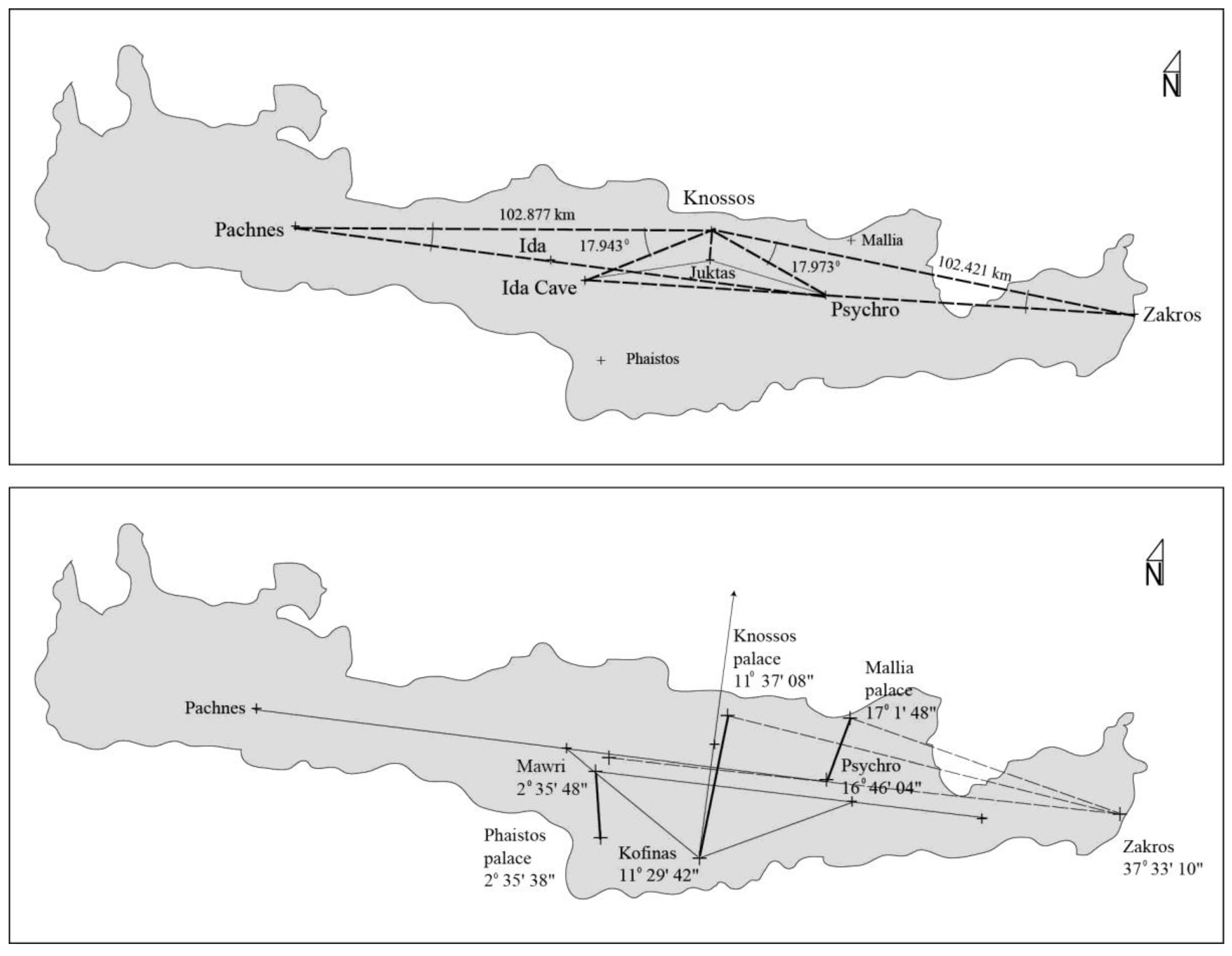
The best example of archaeological citation of close mapping has been the patterns of palace location and orientation on Minoan Crete [11], Figure 1. Rather than continue long held assumptions about classical palaces as territorial locations of powerful rulers, and architectural history claims of orientation to prominent natural features in the immediate viewshed, the location of Knossos was determined by the formal geometry of most prominent mountains and caves at island scale. While the peak sanctuary on Juktas played a ritual role in earlier Minoan culture, Knossos does not orient to this visible mountain feature. The orientations of all three central “palaces” were determined by their relationship to three natural features of larger pattern. This article includes the theoretical reversal of ideas that many historical or prehistorical monuments were located for territorial reasons, and only after oriented buildings to prominent natural features. Termed “extension”, this compared to its opposite of “intention” where geometric formalities in the large landscape were laid out first, and subsequently used for both location and orientation.
Figure 1.
Theoretical “intension” on Minoan Crete in the classical period, where formal patterns among most prominent natural features preceded the location and orientation of “palaces” [11].
Figure 1.
Theoretical “intension” on Minoan Crete in the classical period, where formal patterns among most prominent natural features preceded the location and orientation of “palaces” [11].
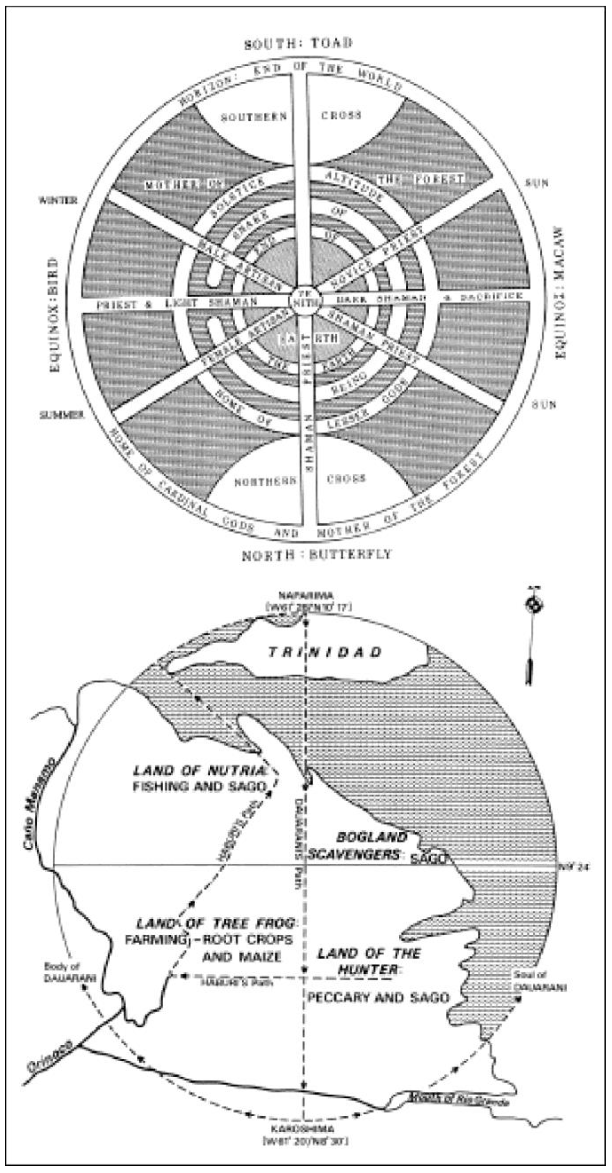
While Classic and Preclassic Mesoamerican archaeologists have more than enough to keep them occupied at domestic and urban scales, they have yet to investigate obvious technological abilities to land survey larger landscapes. An exception here comes from the cultural anthropologist, Johannes Wilbert [12]. His documentation of the relatively “primitive” Warao tribe living in the jungle lowlands of the Orinoco Delta in Venezula stands as one of the most complete understandings of how spatial structure of native religion reached out from shaman practice in the communal round house to a known, land surveyed large scale cosmos, Figure 2. While not primarily focusing on this geographic aspect of their religion, Wilbert reported shaman visits to distant natural features and managed to verify from a light aircraft the accuracy of cardinal axes, off less than one degree across a space well over one hundred kilometers.
Figure 2.
Formal structure of ritual space at all scales of Warao religion: cosmos to communal round house with central pillar [11], (pg. 89 above, pg. 11 below).
Figure 2.
Formal structure of ritual space at all scales of Warao religion: cosmos to communal round house with central pillar [11], (pg. 89 above, pg. 11 below).
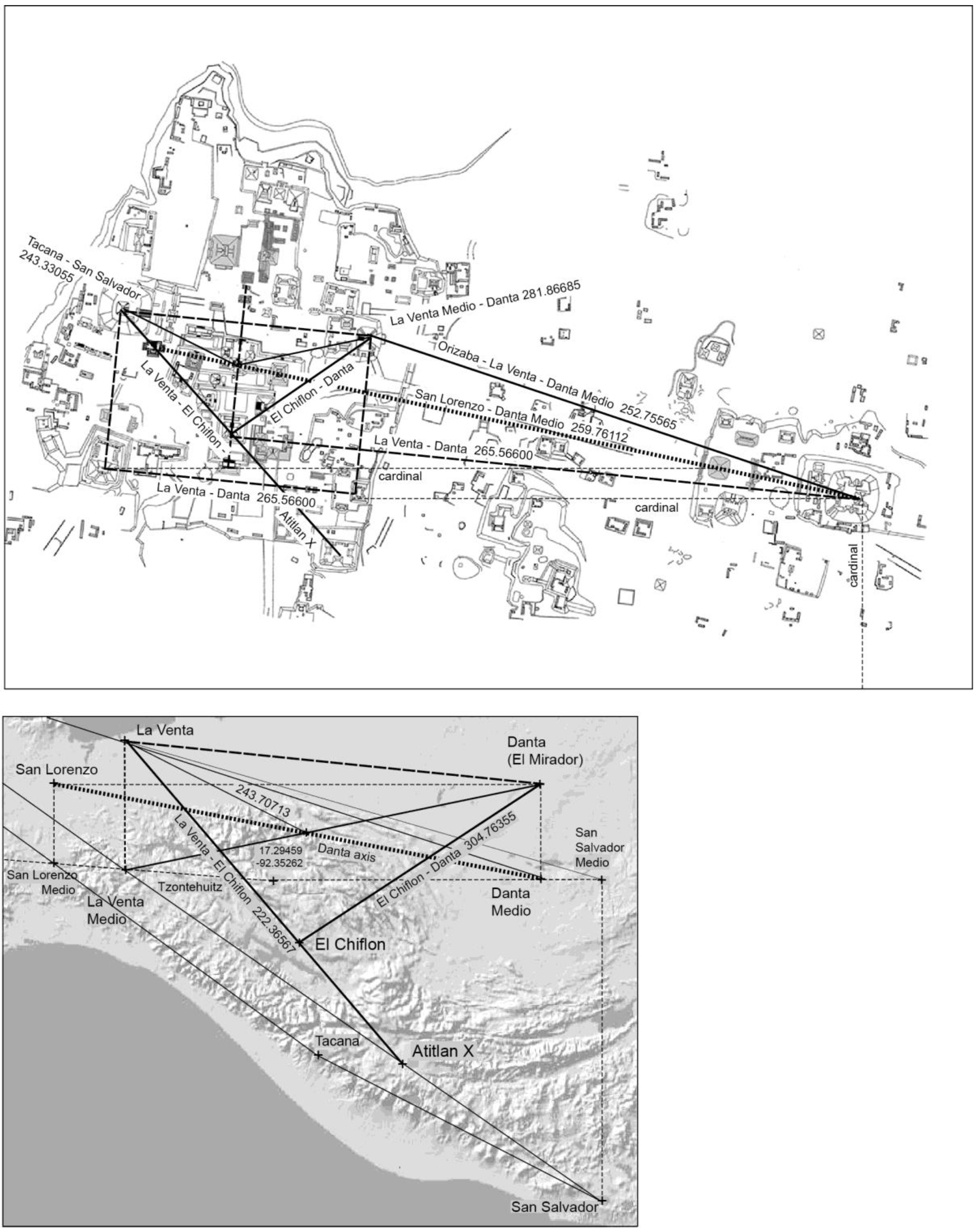
Any review of Mesoamerican religion, however, quickly illustrates not dissimilar “cosmic” underpinning of Olmec and Mayan ethnography and archaeology, the Warao example most likely influenced by ancient landscapes to their north. Close mapping these settings, beginning with the Olmec, finds a powerful devotion to accurate meridians and alignments among towering volcanos in the Mexico valley where Teotihuacan was eventually built. Hypothetically, this “primordial” pyramid shaped landscape organizing several accurate coincidental alignments into the pattern was reproduced by Olmecs at La Venta, integrating the layout into not dissimilar coincidental equinox alignments of mountains in a landscape between Mexico valley and Atitlán. The location and orientation of La Venta -- tested against random phenomena -- serves to locate early Mayan urban ceremonial sites such as El Mirador with its pyramid La Danta, considered one of the largest in the world, Figure 3.
Figure 3.
Pyramidal shaped Maya landscape evolved from Olmec pattern at La Venta; site location of El Mirador and reproduction of landscape pattern at its urban scale [5].
Figure 3.
Pyramidal shaped Maya landscape evolved from Olmec pattern at La Venta; site location of El Mirador and reproduction of landscape pattern at its urban scale [5].
Probability tests comparing existing with random geometry in this work demonstrate that individual elements as alignments, cardinals and right-angles often exist in simple numbers well above the purely coincidental. Testing of more complex formal patterns can provide design related evidence, see comparison of Ancestral Pueblo (Chaco), Mayan (Tikal) and Adena/Hopewell (Ohio River) landscapes in [9].
2. Materials and Methods: Yggdrasil as Map?
While large scale Mesoamerican landscapes are yet to be close mapped, New World historians and archaeologists would doubtfully question the technical abilities of the Maya, or even Olmec to craft simple plumb bob transits to lay out accurate geometry of ceremonial structures. The same might be said of scholars investigating 10th century “Trelleborgs”. Yet assumptions that master builders didn’t use survey tripods beyond the scale of a ring remain latent. This in part because current publications conclude that ring borg locations are primarily rhetorical territories along road viewsheds – with the exception perhaps of Aggersborg’s position on a waterway [13,14,15]. Nor have the five interior cross axes been extended as azimuths into the larger landscape (including Lembecksburg).
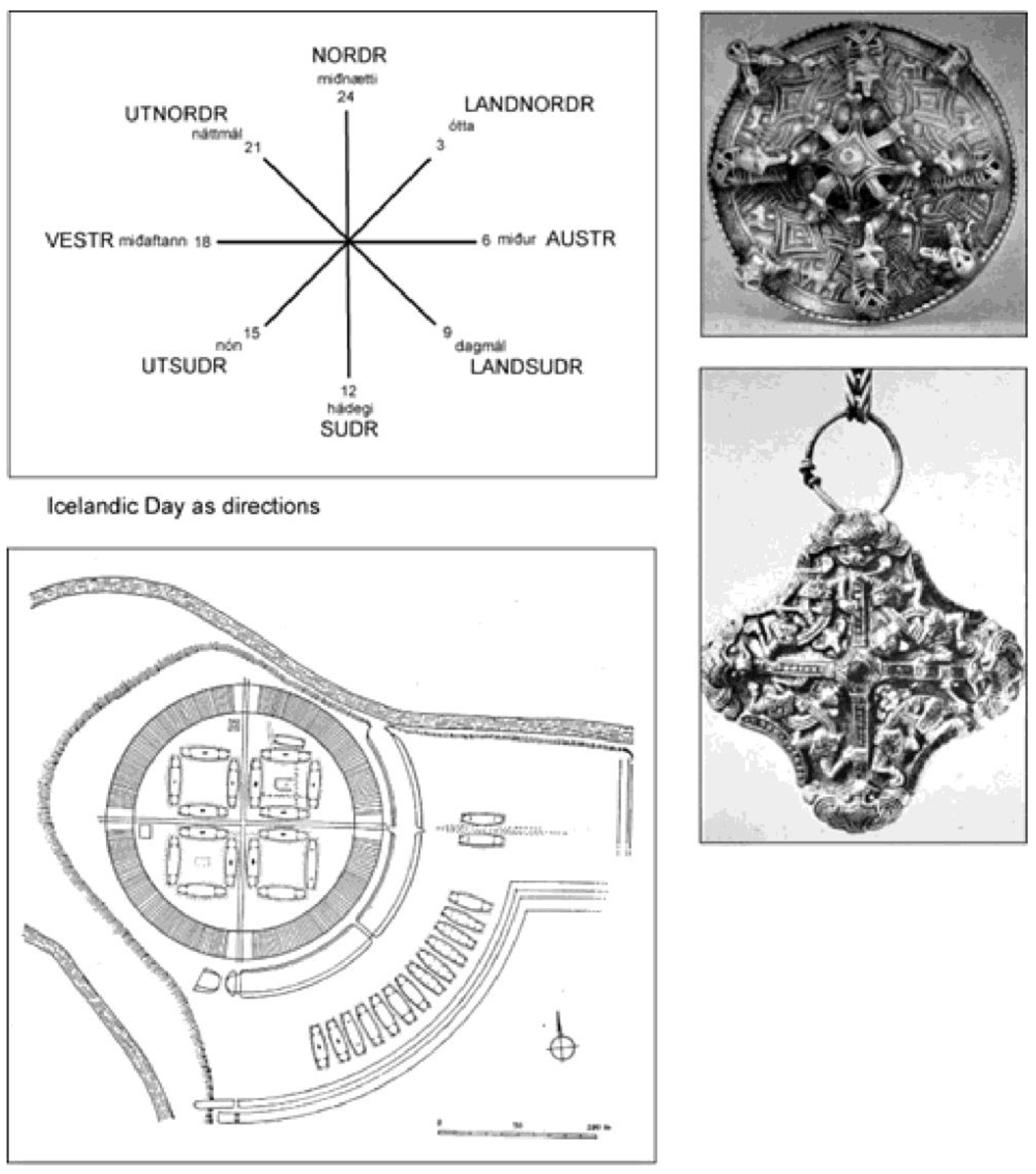
The formal geometry shown in other cultures above were likely religious symbols, even though some pattern elements may be naturally coincidental. Conceptually they do not differ from the Scandinavian cross designs in Figure 4. Not imaged here is the saga defined cross structure of the universe as Yggdrasil, scholars maintaining this pattern only existed as myth and folklore [16,17,18]. Yet ring borg geometries could have evoked this mythology. So before illustrating mapped patterns within and among the ring borgs, the stage needs to be set for their possible extensions into some earlier formalized Yggdrasil cross in the greater Scandinavian landscape, origins of borg occupants [19].
Figure 4.
Cross structures as Icelandic time, Swedish Historical Museum (brooches/pendants) Viking ring borgs, and pendants.
Figure 4.
Cross structures as Icelandic time, Swedish Historical Museum (brooches/pendants) Viking ring borgs, and pendants.
The author’s search for a Scandinavian cross a decade ago involved first testing whether the most prominent natural features and largest “memorial” mounds created pattern (whether anyone was buried or not). See list of Figure 5. Sites in Norway and Sweden were found in archaeological literature along with histories of prominent natural features. Denmark’s far greater number of large mounds, surpassing 50 meters in diameter, posed a greater challenge. Finally, a young IT employee at Slots og Kulturstyrelsen was persuaded to search for this size among the thousands listed in their database. Surprisingly, only sixteen made the list, not considering pairs of mounds close to this limit. The fee for this service was four bottles of Chardonnay delivered to the front desk of an imposing building in the center of Copenhagen.
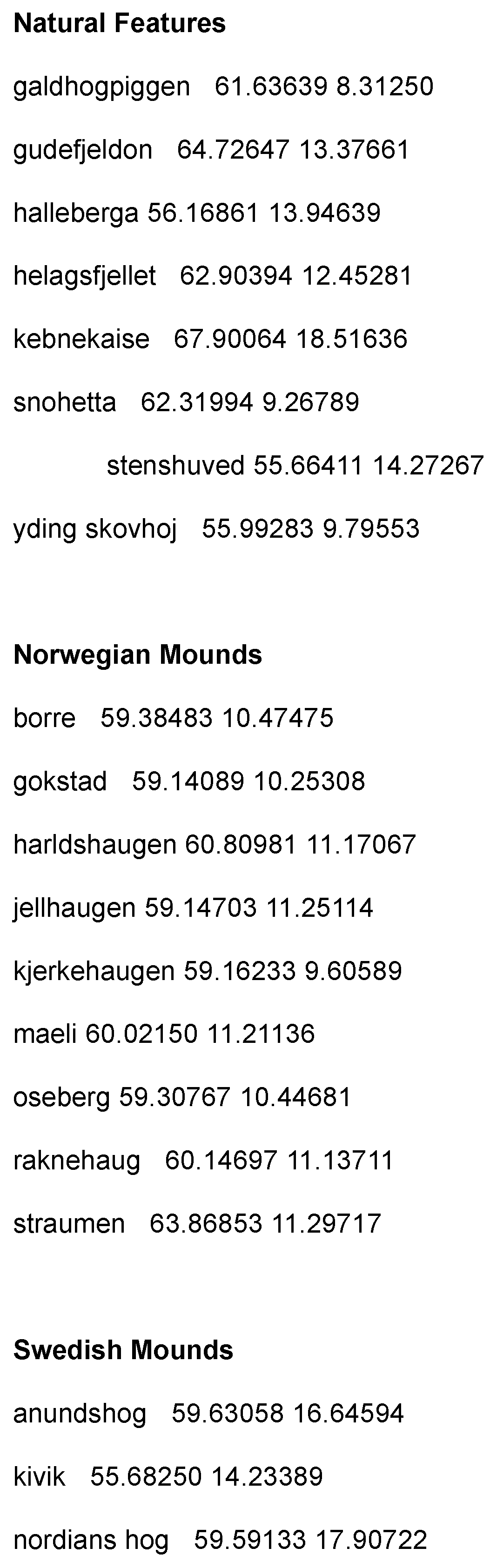
When one tests the list, the number of accurate existing geometric “elements” clearly exceeds the random in a large number of substitution sets. Then, given background in the SW Ancestral Pueblo and Minoan Crete, could one find and test a larger more complex “cosmic” pattern? The following is one of several unpublished tests for design intent. Was there a Scandinavian cosmos resembling a Yggdrasil tree with three axes [20,21]?
A “top” of this cross runs from the highest mountain benchmark in Norway (Galdhøpiggen) to the highest in Sweden (Kebnekaise), with an aligned natural threshold at Straumen (strait). Figure 6. Also shows how other, more visually impressive natural features can be found to express possible end points of three axes: SW – NE, NW – SE, and cardinally N -S. Twelve natural features, including Straumen, create alternatives of three cross axes. What then is the likelihood that largest mounds in three areas where greatest numbers occur, will align with any of the cross elements (shaded areas on the possible cross axes).
Replacing existing mounds with identical numbers located randomly in test areas one first seeks points that align within 0.06° with axes. Visual acuity with the unaided eye, is 0.017°. To sense the size of this deviation, consider the Straumen inlet on the 848.278 km line between Galdhøpiggan and Kebnekaise. Its average deviation (considering the angles from both ends) is 0.058°, a distance off about 295 meters.
Figure 6.
Possible large-scale cross lines between most prominent natural features on which either existing or randomly located mounds may accurately align.
Figure 6.
Possible large-scale cross lines between most prominent natural features on which either existing or randomly located mounds may accurately align.
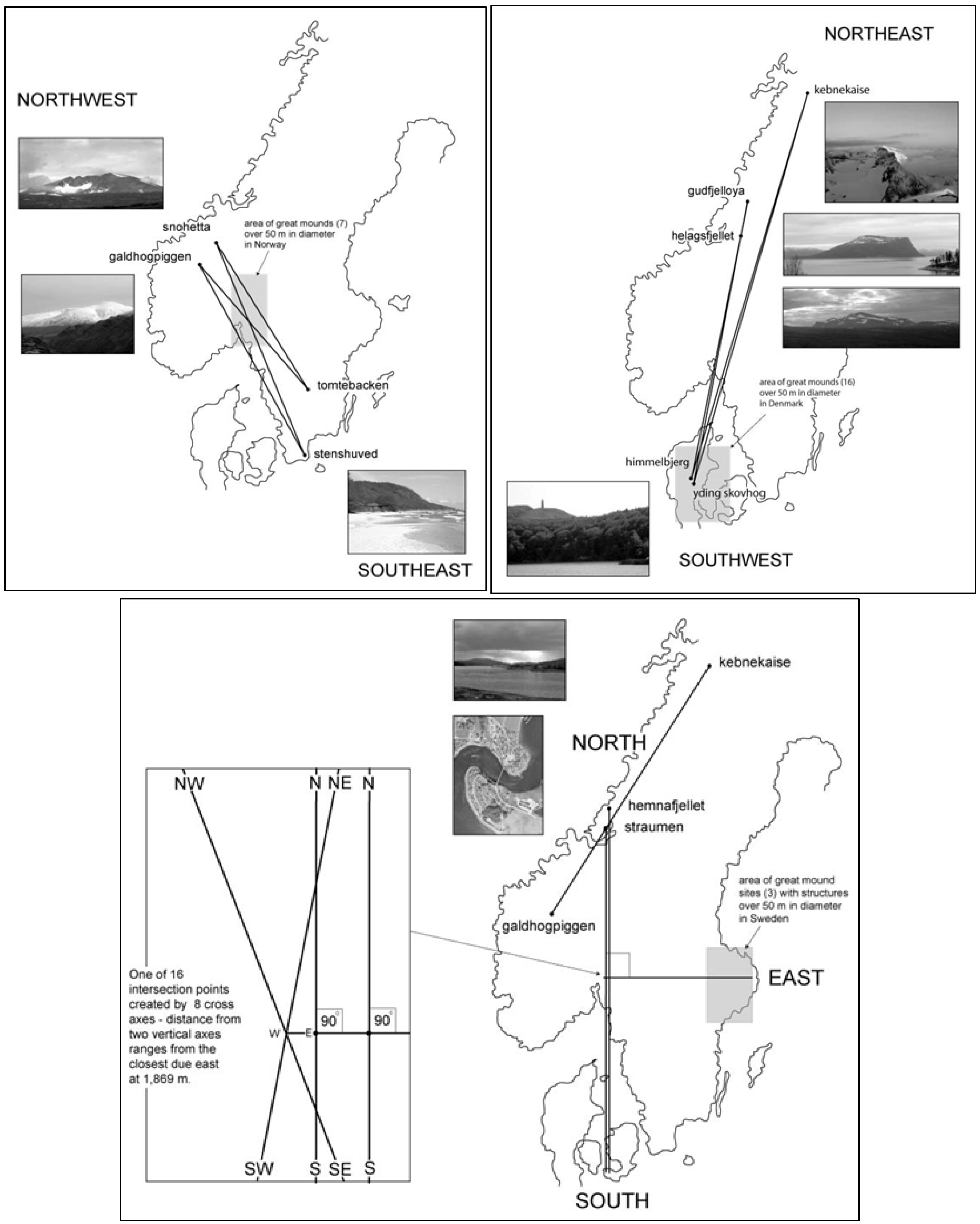
Ten thousand trials examine sets of random points numerically equaling the existing number of great mounds distributed in each of the three test areas (12, 8 and 3). In Denmark, the probability of one of the 12 random points aligning with one of the four possible intercardinal lines is 0.051 (1 in 19.6 sets or 1 in 235.2 points in total). Up in Norway, the probability of one of the 8 random points aligning with a NW – SE line is about the same at 0.057 (1 in 17.5 sets or 1 in 140 in total). Threesomes of random points in the Swedish test area create a perpendicular with either of the meridian pair (each with a North site plus unifying point) at a much less frequent rate of 0.006 (1 in 166.7 sets or 1 in 500.1 random points in total). Multiplying statistically these three figures, one arrives at the probability of a potential unified cross pattern forming at the 0.06° level. The odds of two mounds in Danish and Norwegian test areas aligning on two cross axes – all intersect -- are 0.0029 (1 in 344.8 times), while those of a ninety connection to one of the two meridians are 0.000017 (1 in 58,823 times). This, however, does not measure odds that the Swedish cardinal will align with the particular cross axes intersection.
To partially solve this problem, only the two intersecting cross alignments and perpendicular using the largest mounds are tested, Hohøj (0.016° 72m) in Denmark, Raknehaug (0.029° 77m) in Norway, and Uppsala (270.07768° 70m x 3) in Sweden (Jelling, because of its late Viking date is excluded). In this scenario, the cross-intersection point is fixed and provides a target for a Swedish perpendicular. When one runs 10,000 such trials – using the precise existing accuracies – a random point replaces Hohøj in the Danish test area at a rate of 0.0053 (1 in 189 tests), and Raknehaug in the Norwegian area at a rate of 0.0076 (1 in 132 tests), and a perpendicular random point replaces Uppsala in the Swedish test area at a rate of 0.0019 (1 in 526 tests). None of these random points align with each other in the same set or roll of the dice. Statistically multiplying these three numbers together gives a microscopically small likelihood that all three of the largest of mounds align with these cross lines coincidentally at the same time.
2.1. New Large-Scale Maps of Ring Borg Locations and Orientations
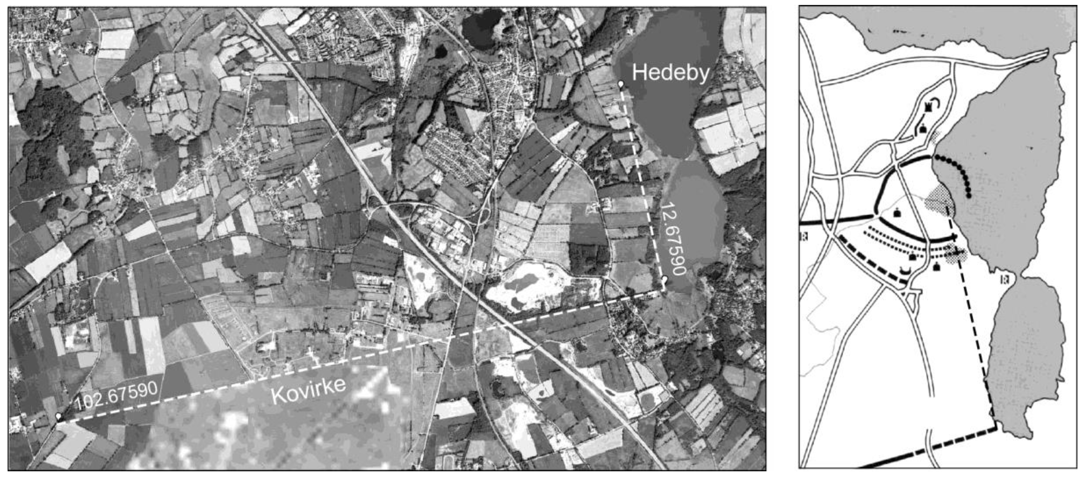
Centuries earlier, Romans located a string of watch towers across hilly terrain in Germany [22]. The greatest deviation of any tower along the Neckar River was two meters (deviation of about 0.016° at an average distance between towers of about 7,000 meters). This distance is just about the length of the arrow straight piece of the Danevirke called “Kovirke”, Figure 7. When one calculates with custom mapping software the azimuth north from the point where the Korvike meets the lake, it forms a seemingly accurate right angle to the center of the trading town of Hedeby. This azimuth must have been laid out by craftsmen with land surveying ability, undoubtedly using tripods and plumb bobs. The instruments seem likely used at Ravning Enge. Was the geometry of the Hedeby right angle symbolic, and similarly why were the Romans interested in very straight lines, not necessary for communication between towers?
Figure 7.
Right angle relationship between eastern terminus of Kovirke and center of Hedeby.
Not unrelated to this symbolism, may be the orientations of the ship setting and palisade walls at Jelling, Figure 8. Most evident is the very accurate larger-scale alignment of the ship setting and great mounds to the high landscape point of Himmelbjerget, over 42 km. Also, the two west/east sides of the palisade do not point to Himmelbjerget but run quite accurately to the center of the Fyrkat borg. The azimuth of the east wall reads 347.41600°, while that from Jelling center point to Fyrkat’s center is 347.42143° (present software uses a counterclockwise rotation from north as 0 or 360). The azimuth of the north palisade is 272.53011, not pointing to any site. But given the other walls orientation to Fyrkat, what about Aggersborg? The azimuth from Jelling’s central mound to the center of Aggersborg is 4.15152°, as a ninety-degree perpendicular, this possibility is close but less accurate than Fyrkat’s, i.e., off 1.62141°.
Figure 8.
Orientation of Jelling ship setting to Himmelbjerget; east – west parallelogram sides orient accurately to Fyrkat, north – south sides are possible perpendicular to Aggersborg.
Figure 8.
Orientation of Jelling ship setting to Himmelbjerget; east – west parallelogram sides orient accurately to Fyrkat, north – south sides are possible perpendicular to Aggersborg.
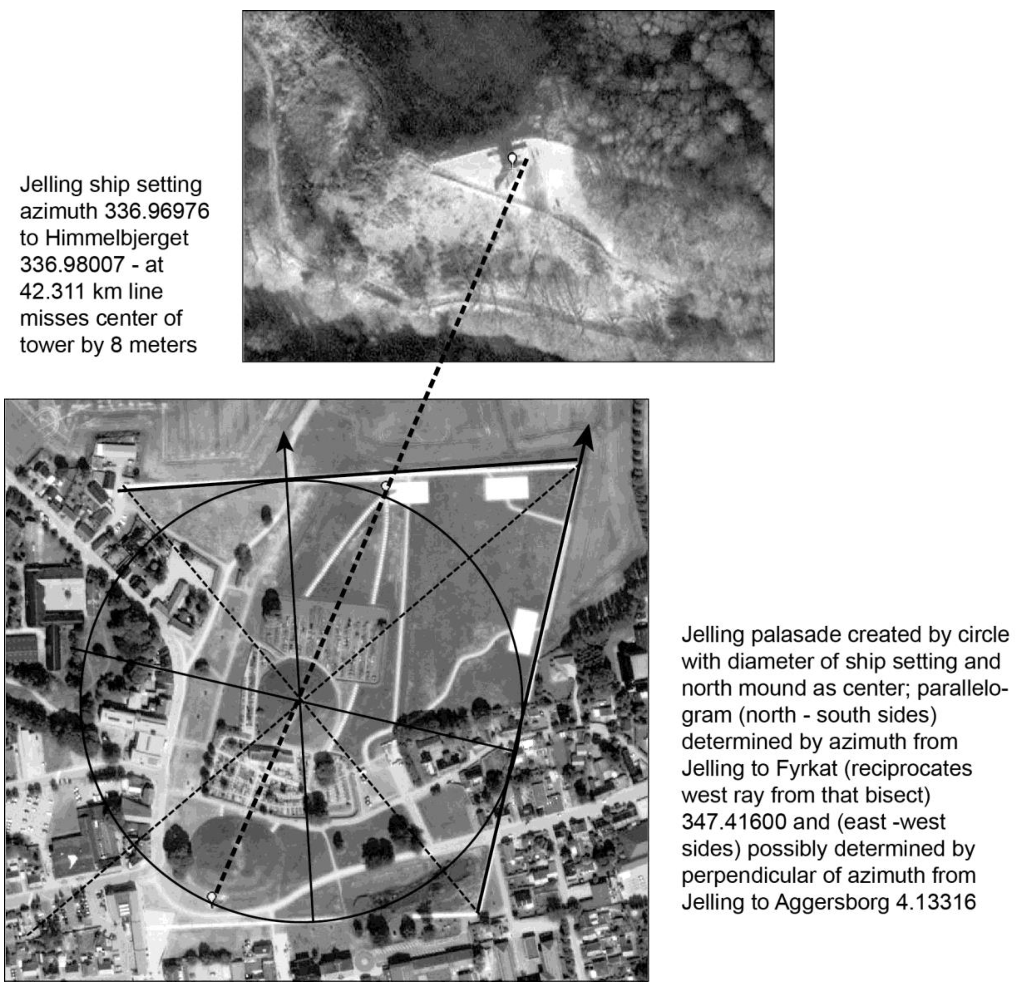
Hypothetically, if Jelling’s palisade azimuths symbolized a kind of spiritual protection by what ever the ring borgs intended—perhaps because Jelling’s location was determined in an earlier landscape—then analysis of borg location and orientation should logically include large-scale azimuths.
2.2. Aggersborg
Beginning with the largest of the ring structures, its location is the only one of the six suggested by archaeologists to have been positioned for transportation purposes. Yet when one maps large-scale azimuths, this water linked topography also lies quite accurately as a meridian prolongation south from the summit benchmark of the historically regarded highest mountain in Norway, Snøhetta, the NW terminus of the cross axis tested above. If craftsmen had land-surveyed the 593.184 km line as a meridian, they missed the Aggersborg center by 179.92343°, or 792 meters to the west, Figure 9.
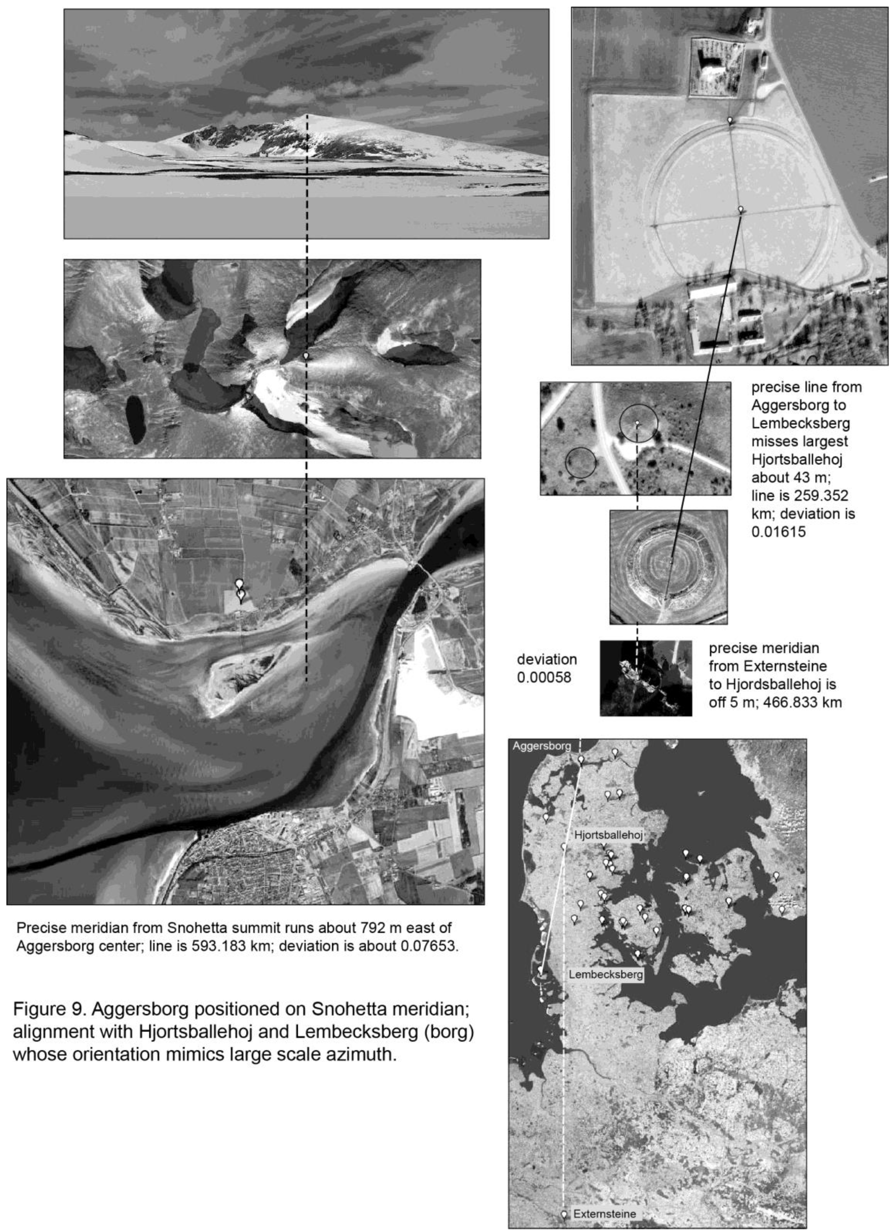
If this logically highly symbolic meridian was the only determining longitude for Aggersborg, water access might have provided a second intersecting consideration. But a different symbolic element exists in an accurate three-point alignment running from the center of Aggersborg to the center of the smaller Lembecksberg, with an intermediary Hjortsballehøj mound. Lembecksberg’s orientation emulating the line provides a key pattern component to the concept. Hjortsballehøj (together with its slightly smaller partner) dates to “Oldtid” [23]:
“Høj, “Hjortsballehøj”, 4,5 x 49 m. Stor hulning i top fortsættende med kløft mod øst og vest. Siden ujævn. Lynggroet på åben plads i plantage. (Nær østre fod et mindesmærke for Hedeselskabet)”.
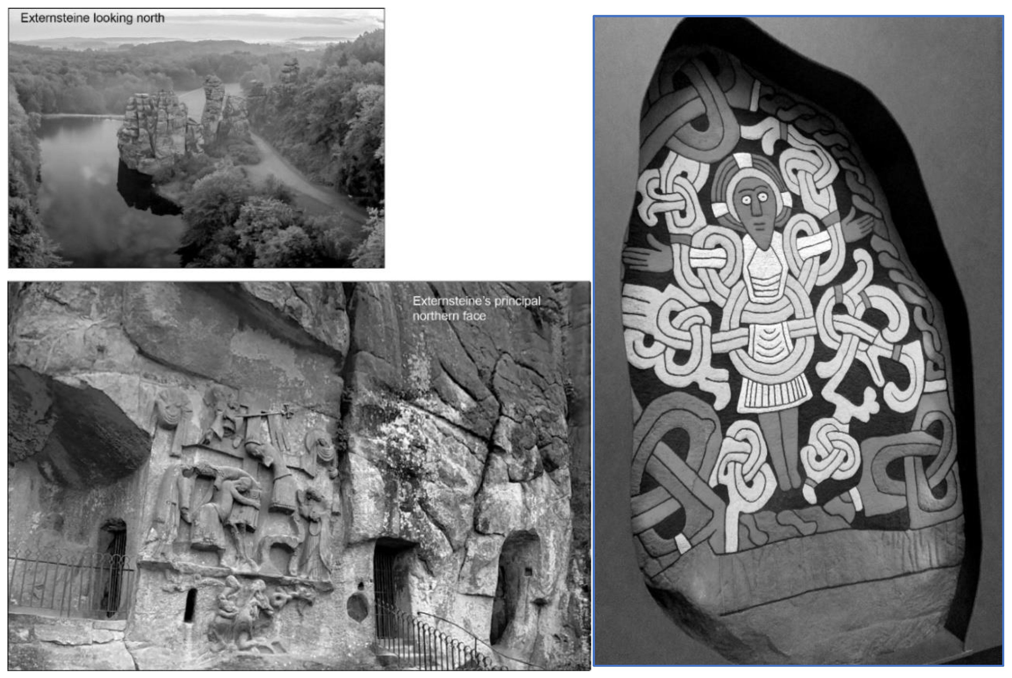
A second patterned element exists with the early medieval Germanic/Christian site of Externsteine that forms a very accurate meridian to Hjortsballehøj in an extension of an Aggersborg “construct”; the azimuth from Externsteine 466.822 km to Hjortsballehøj is 0.00053°. Again, any individual element, however accurate, could be random. While popular folk conceptions of Externsteine history are extensive, archaeological excavation in the 1930’s determined its earliest use as a spiritual site in the 10th century [24]. Discourse about the early Christian fusion of Irminsul and Yggdrasil tree image in the disposition of Christ, and differences between the two shows in Figure 9. See Murphy’s [25] piece on the Extersteine relief and later chapter on the Jelling stone introducing related Yggdrasil symbolism on Norwegian stave churches, Bornholm round churches among other examples [26]; or that from archaeologist Andren describing burials in oak trees and the like [27].
Figure 10.
Germanic/Christian natural formation Externsteine showing the descent from the cross supported by a tree (left); related iconography from Jelling Stone where Christ is not on cross but in the branches of a great tree. Robert Hale medieval.ucdavis.edu (right).
Figure 10.
Germanic/Christian natural formation Externsteine showing the descent from the cross supported by a tree (left); related iconography from Jelling Stone where Christ is not on cross but in the branches of a great tree. Robert Hale medieval.ucdavis.edu (right).
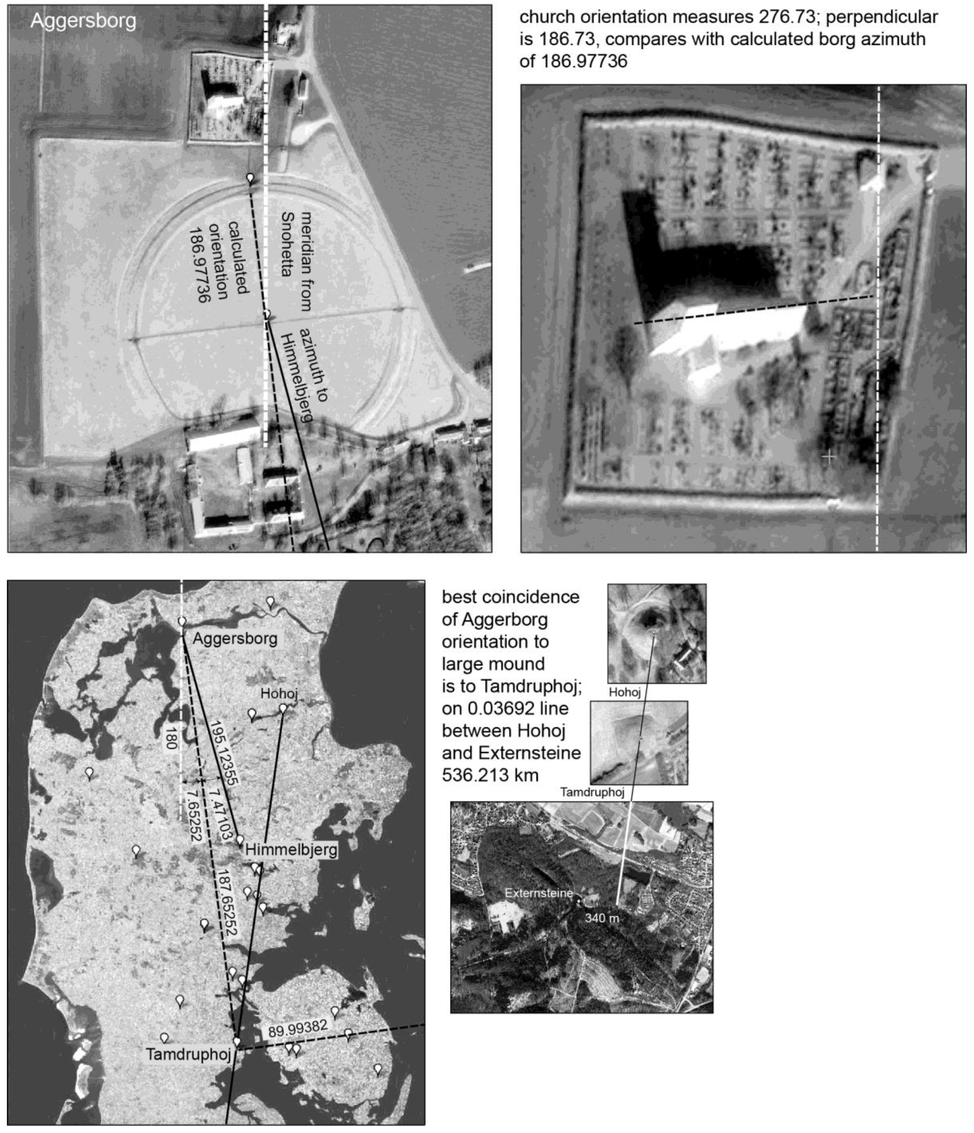
Placing software markers on the internal axis of Aggersborg, its azimuth runs about 186.97736° south. Searching the list of largest mounds in Denmark, the best fit is to Tamdruphøj at an azimuth from Aggersborg’s center of 187.65252°, Figure 11. No dating is listed for this only 43-meter mound (included in the original IT search). The 0.03692° average deviation alignment from Externsteine to the terminus of the SW – NE cross Hohøj (excluding Yding Skovhøj) runs 536.217 km missing Tamdruphøj about 99 meters to the west. Additional pattern complexity exists as the azimuth to Tamdruphøj forms a modest bisector to a 180° meridian and azimuth to Himmelbjerget from the Aggersborg center. This bisect has an error of about 0.090745° and would be about twice as inaccurate if the precise meridian from Snøhetta to Aggersborg were used.
Figure 11.
Aggersborg orientation in relation to Tamdruphøj, bisect with meridian and Himmel-bjerget, alignment with Externsteine and Hohøj.
Figure 11.
Aggersborg orientation in relation to Tamdruphøj, bisect with meridian and Himmel-bjerget, alignment with Externsteine and Hohøj.
A very accurate right angle also exists between Tamdruphøj as vertex with Aggersborg and the paired site of Galgebakken / Hashøj vertically close to Trelleborg, Raevhøj and Bavan on the southern terminus of the cross meridian. The number here is 89.993829° to the northern of the pair.
When the stone church was positioned immediately north of Aggersborg, about one hundred and forty years after the ring was built, it accurately reproduced the cross ring’s orientation (bisect to Tamdruphøj?) but left intact a possible spiritual flow on the Snøhetta meridian.
2.3. Trelleborg at the Cross Meridian
The intersection of the two best “Yggdrasil” cross axes, Figure 6, occurs about 4.457 km west of the Straumen meridian. Raknehaug, a Migration Period (400-550 A.D.) structure stands about 11.601 km farther to the northwest on the Snøhetta-Stenshuved line. Dualistically, one would expect a partner to Raknehaug in a similar position on the opposed Gudfjelløya-Helagsfjãllet-Hohøj (Yding Skovhøj) axis. One possibility is an uncompleted “platform” (site description) about 76 m by 40 m on the Mæli farm, on which eventually were built 5-6 grave mounds ranging from 20 m to 6 m (Askeladdan # 42319). The Mæli feature sits 3.284 km from the cross axes intersection point, closer and asymmetrical compared to Raknehaug’s 11.601 km distance. Topographically the line from Gudfjelløya to Yding Skovhøj misses the center point of the platform by about 272 m, an average deviation of 0.032°. If the line was older than the mounds on them, the position of “Mæli” could have been prolonged from Gudfjelløya through Helagsfjället, with its more precise 0.009° to Gudfjelløya-Mæli.
The latitude of the cross-axis intersection point was in earlier work projected 4,457 meters east to its intersection point on the Straumen meridian near the small farm Jultonstua in Sørum. Nothing in the archaeological record mentions any central ceremonial place here or at related Julton farms. Topographically interesting is Jultonåsen (åsen = ridge). Local history describes a Jotun or mythical giant residing in this north-south feature [28] (503). Unconfirmed local stories tell of a cloister of monks in the Julton farm area. The farm name, according to Oluf Rygh derives from the plantname “jol”, combined with “ton” or flat place. Rygh says that the derivation of the winter solstice “Jul” from the plant name is not dissimilar to the linkage with the Julton name. Could “Julton” have been a winter ritual setting, not unlike that at Uppsala [29]. The most analytically interesting aspect of a hypothetical “Julton” point, however, is its right-angle vertex with the Straumen meridian and Uppsala, the largest great mound(s) of the Swedish test area, 90.007°.
Trelleborg’s “meridian” location 359.90444°, though cardinally close does not seem to compete with the more precise relationship of Raevhøj and Baven to Straumen noted in Figure 12. A more accurate pattern may have located this ring at the center, via a relationship to Raknehaug on the Snøhetta – Stenshuved axis—and its cross relation to Julton. Trelleborg’s orientation leads us in this direction. The “east – west” azimuth of Trelleborg is about 259.40046. Earlier work [30] dispelled the idea of archaeoastronomical reasons behind orientations of three of the ring borgs, not yet considering the Borgring, they conclude:
“There is no doubt that the Danish ring fortresses were built in accordance with advanced geometrical and metrological rules. However, this does not at first hand seem to apply to the orientations, although it is conceivable that the orientations could have been set out after formulas we do not know about” pg. 69.
Their theodolite sunshot of Trelleborg’s orientation to the east gate is 100° 58’ (259.033333° using this paper’s azimuthal system). They don’t describe where the instrument was positioned or whether any existing site benchmarks were involved. Present software calculates highly accurate large scale great circle azimuths based on the earth’s ellipsoid geometry (NOAA). While placing markers on center points of borgs and other sites some distance apart is highly accurate, using markers positioned on satellite images at site scales will not be as accurate as a professionally surveyed process.
The author’s azimuth orientation of Trelleborg is 259.40046° and prolongs west to the best large mound, Tårup (to Trelleborg 260.77351°). Here, as elsewhere, archaeological expertize is needed. The latitude – longitude point provided by the IT specialist shows up in the middle of a modern highway, while within a few hundred meters in this forest area three smaller mounds are all labled Tårup. Earliest maps in Slots og Kulturstyrelsen show the lat/long in question at a considerably larger symmetrical mound-like topographical feature, apparently leveled for the highway.
If Tårup existed as a sizeable monument, how could it have served to locate Trelleborg? First, a right-angle exists between Tårup as vertex with the center of Trelleborg and Raknehaug, 89.94652°. Next recording the azimuth from Trelleborg to Aggersborg, looking for a pattern with Tårup, that line runs from the middle long house of the thirteen outside of the primary ring embankment through the center of the ring. Marking the 45° bisect of the cross quadrant, one subtracts 45° from the azimuth from Tårup to Trelleborg’s center 260.77351 – 45 = 215.77351°. Now adding the azimuth from Aggersborg through the Trelleborg center to the middle long house, 215.82869°, the azimuths of the two large scale lines create a bisect within about 0.056° (or 0.028° divided by two).
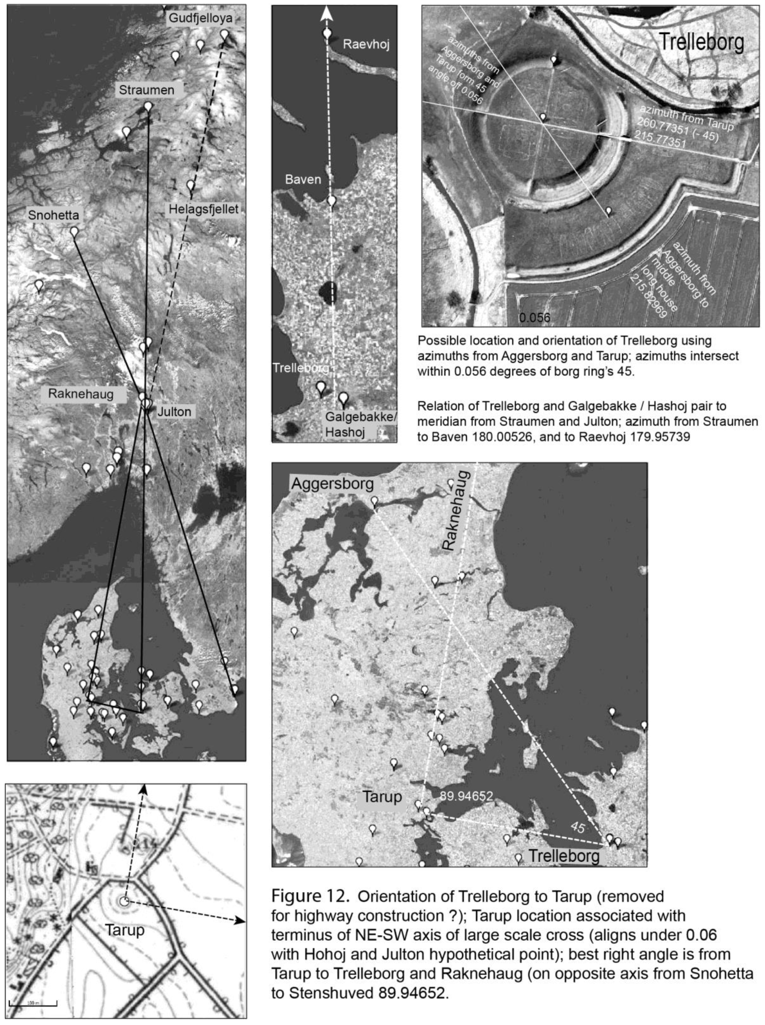
The pattern of this large-scale bisect similar to the Trelleborg cross axis suggests that the azimuth from Tårup, knowing its right angle to Raknehaug near Julton, may have been prolonged east to the vicinity of the Straumen meridian. A second line might have begun at an estimated point just northwest of Galgebakke / Hashoj and prolonged 45° from the Tårup azimuth toward Aggersborg. Stringing survey stations at intervisible points between the start point and Aggersborg, surveyors could have straightened the line moving sequentually back and forth across the full length of the line signting from one station to its two adjacent ones —adjusting the start point to maintain 45°. Did surveyors understand a cognitive map of Denmark, perhaps even on parchment by which to initially estimate azimuths? Again one assumes a hard freeze during winter allow work across stretches of water.
2.4. Trelleborg E (Sweden)
The azimuth from Trelleborg to its namesake in Skåne is somewhat close to cardinal, 269.81398°, but doesn’t compare to most map elements in the range of 0.06° or less deviation. Alternatively, surveyors would have known Trelleborg’s relation to the Straumen meridian was only approximate, compared to older mounds on the central axis. They could have religiously decided to survey an accurate central axis from Trelleborg up to a Julton point (hypothetical). A right angle with this new axis, might then run east to create the first line of a Trelleborg E location 89.98903°, Figure 13. This pattern of the two ring borgs with a meridian north may have captured the cross symbolism between Julton intersect and largest mound site east at Uppsala.
Figure 13.
Right angle pattern between Trelleborg, Trelleborg E. and the hypothetical cross center point, “Julton”; replicates cardinal geometry from center to Uppsala.
Figure 13.
Right angle pattern between Trelleborg, Trelleborg E. and the hypothetical cross center point, “Julton”; replicates cardinal geometry from center to Uppsala.
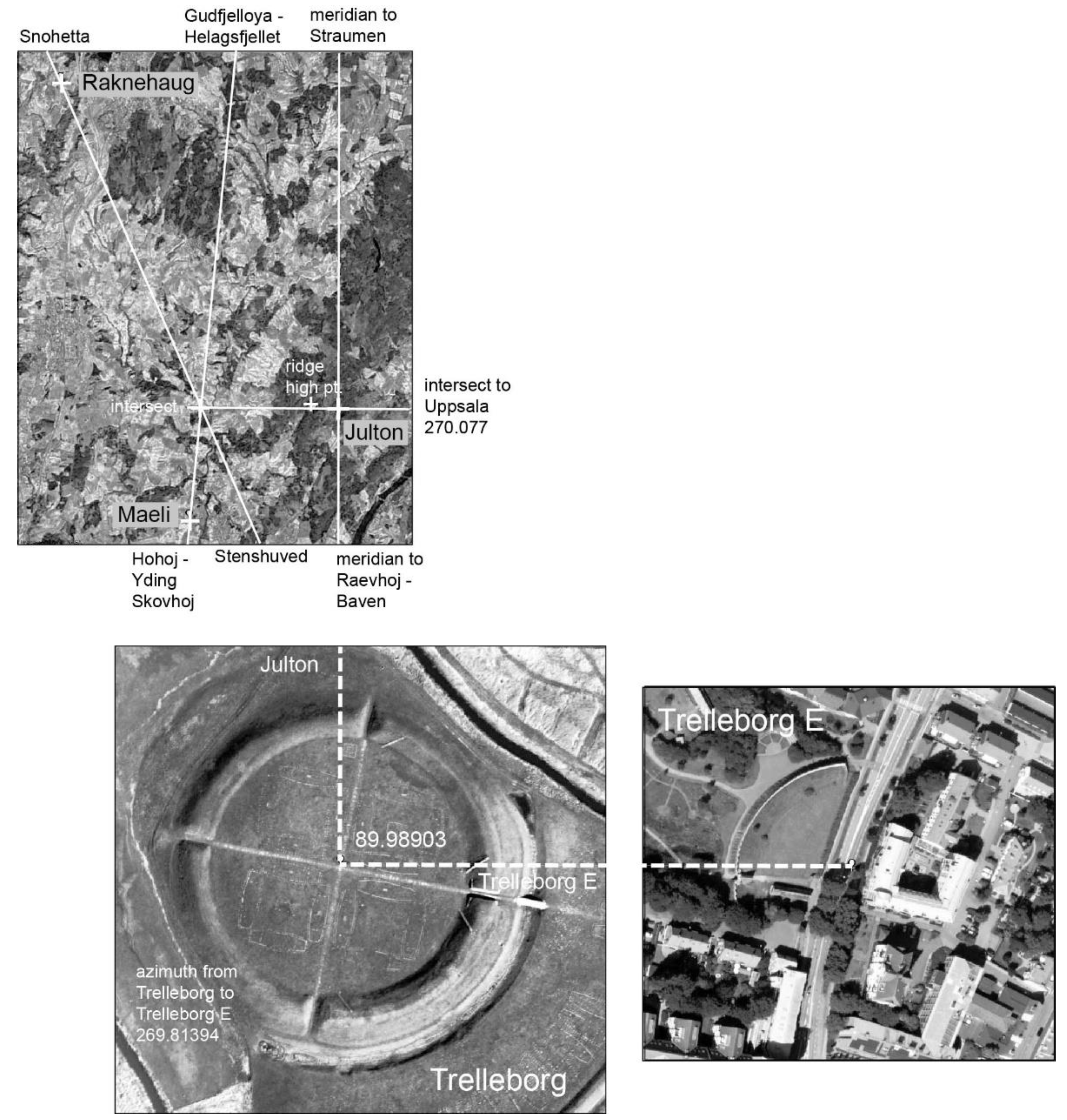
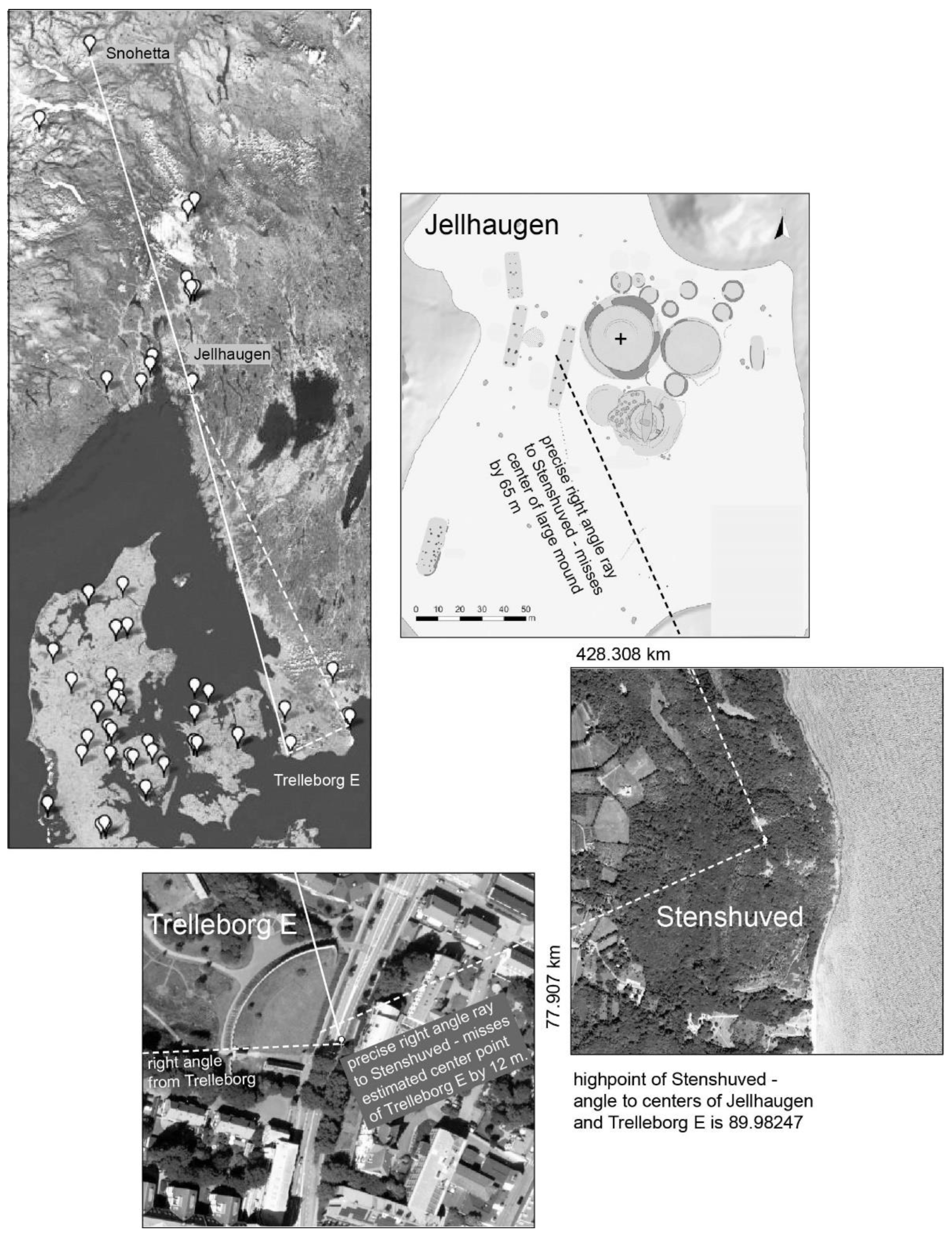
Gjellestad, an important late Nordic Iron Age central place [31] might have provided two possibilities for a second line to position the Swedish Trelleborg. First is a 0.054195° average deviation three-point alignment from Snøhetta through Gjellestad to Trelleborg E. If surveyed from Snøhetta, this deviation across 804.896 km would have positioned Trelleborg E. off about 822 meters west of the line. Alternatively, this location could have been determined without the symbolically important line to Snøhetta. Using the SE terminus of the Snøhetta – Raknehaug cross axis, Stenshuved, a line from Gjellestad to this natural feature as vertex could have created a right angle ray down to Trelleborg E, 89.98247°. The right angle from Stenshuved has more pattern than the simple alignment from Snøhetta, and could have connected the easternmost ring borg with the SE terminus of this cross axis seemingly preferenced by master builders.
Satellite imagry doesn’t enable estimation of Trelleborg E’s orientation.
Figure 14.
Right angle with vertex at Stenshuved, SE terminus of cross axis to Raknehaug and Snøhetta: rays to Trelleborg E. and Gjellestad.
Figure 14.
Right angle with vertex at Stenshuved, SE terminus of cross axis to Raknehaug and Snøhetta: rays to Trelleborg E. and Gjellestad.
2.5. Borgring
This recently documented ring borg may have been aligned at an average deviation of 0.05143° with one of the very largest mounds, Buskehøj, and the NW-SE southern terminus of Stenhuved, Figure 15. From Slots og Kulturstyrelsen:
| Rundhøj, Oldtid (dateret 250000 f.Kr. - 1066 e.Kr.) |
| Syd for Glamsbjerg og med udsigt over Helnæsbugten ligger en samling af Danmarks største og mest imponerende gravhøje. Kun fire høje kan ses i dag (Buskehøj, Bohøj, Drengehøj og Lusehøj), men på disse morænebakker med udkig over Helnæs Bugt har tidligere tronet mange andre høje. Omkring storhøjene Lusehøj, Bohøj og Buskehøj er alene 10 mindre høje sløjfet på marken. |
| Høj, “Buskehøj” Meget stor rundhøj, 9 m høj, 90 m (Ø/V) x 75 m (N/S). Fladt topplateau, ca. 12 m i diameter; i østkanten af dette en recent, mindre nedgravning, 0,4 m dyb, 2 x 4 m. Hele vejen rundt om højen, i niveau 1-2 m over terræn, ses en omløbende, ca. 2 m bred afsats. |
What geometry provides a second, intersecting line to locate Borgring? One first looks at azimuthual coincidence of two distant points closest to the measured orientation of its east-west cross axis, 71.24057° -- to Hjortsballehøj 70.49477° and Holger Danskes Høj 71.80960°. The complex pattern at Hjortsballehøj makes this option initially interesting, though a precise right angle exists from Buskehøj as vertex to Stenshuved and Holger Danskes Høj, 89.99244°.
Given the positioning of Trelleborg, was Aggersborg similarly determining at Borgring, considering the azimuth between the two looking north, 45.12476° and recalling this angle involved as surveyors straightened the line from to Aggersborg? Surveyors would have required knowledge of approximately where on the Buskehøj – Stenshuved line this 45 would begin. They also may have measured the angle from Hjortsballehøj to Aggersborg and Himmelbjerget, 72.92971°. Then, wishing to use this angle between two of the most powerful points to connect Borgring to Aggersborg, they could have surveyed and straightened the line using the angle to mark a bisect between Buskehøj and Aggersborg.
Figure 15.
Borgring’s position on Buskehøj – Stensfuved line and 45° azimuth to Aggersborg; bisect of this angle with azimuth to Buskehøj is Borgring axis.
Figure 15.
Borgring’s position on Buskehøj – Stensfuved line and 45° azimuth to Aggersborg; bisect of this angle with azimuth to Buskehøj is Borgring axis.
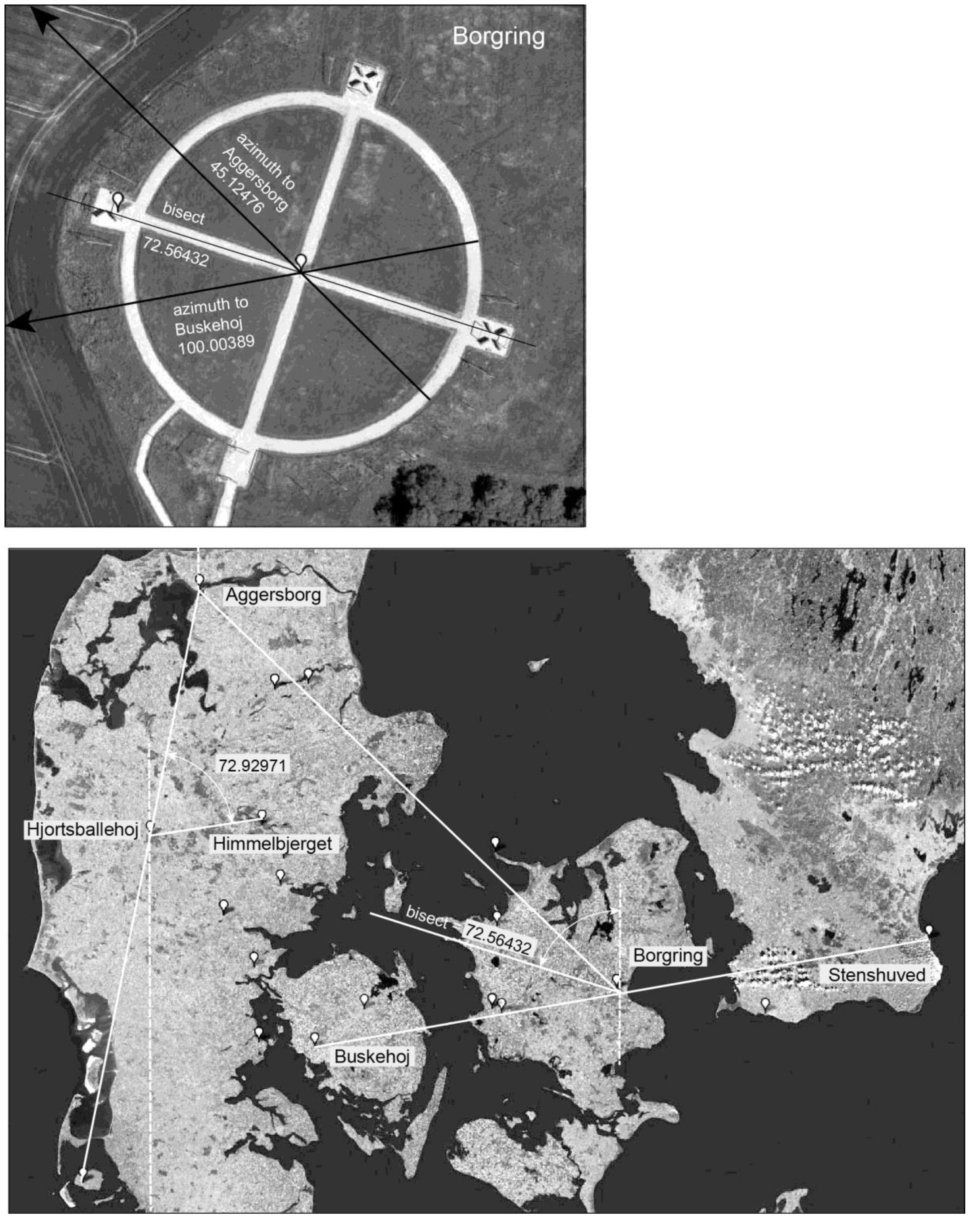
However they did it, the existing bisect between Buskehøj and Aggersborg, 72.56432° lays out relatively accurately as the Borgring visual cross axis. Was Hjortsballehøj also symbolically integrated in this 45° related pattern between Borgring and Aggersborg?
2.6. Nonnebakken
Trelleborg’s location offers a line due west to Nonnebakken, 89.95500°, missing the center of Nonnebakken by 44 meters at a distance of 55.505 km, Figure 16. While a precise line from the center of Nonnebakken to Trelleborg E. will hit the edge of the inner ring embankment at Trelleborg, about 93 meters from the center, this average deviation of 0.07052°, would likely have been more accurate if intentional, and furthermore is not symbolically a cardinal east-west.
Figure 16.
Nonnebakken’s position cardinal west from Trelleborg intersecting with three-point. alignment with Raknehaug and Bertnem.
Figure 16.
Nonnebakken’s position cardinal west from Trelleborg intersecting with three-point. alignment with Raknehaug and Bertnem.
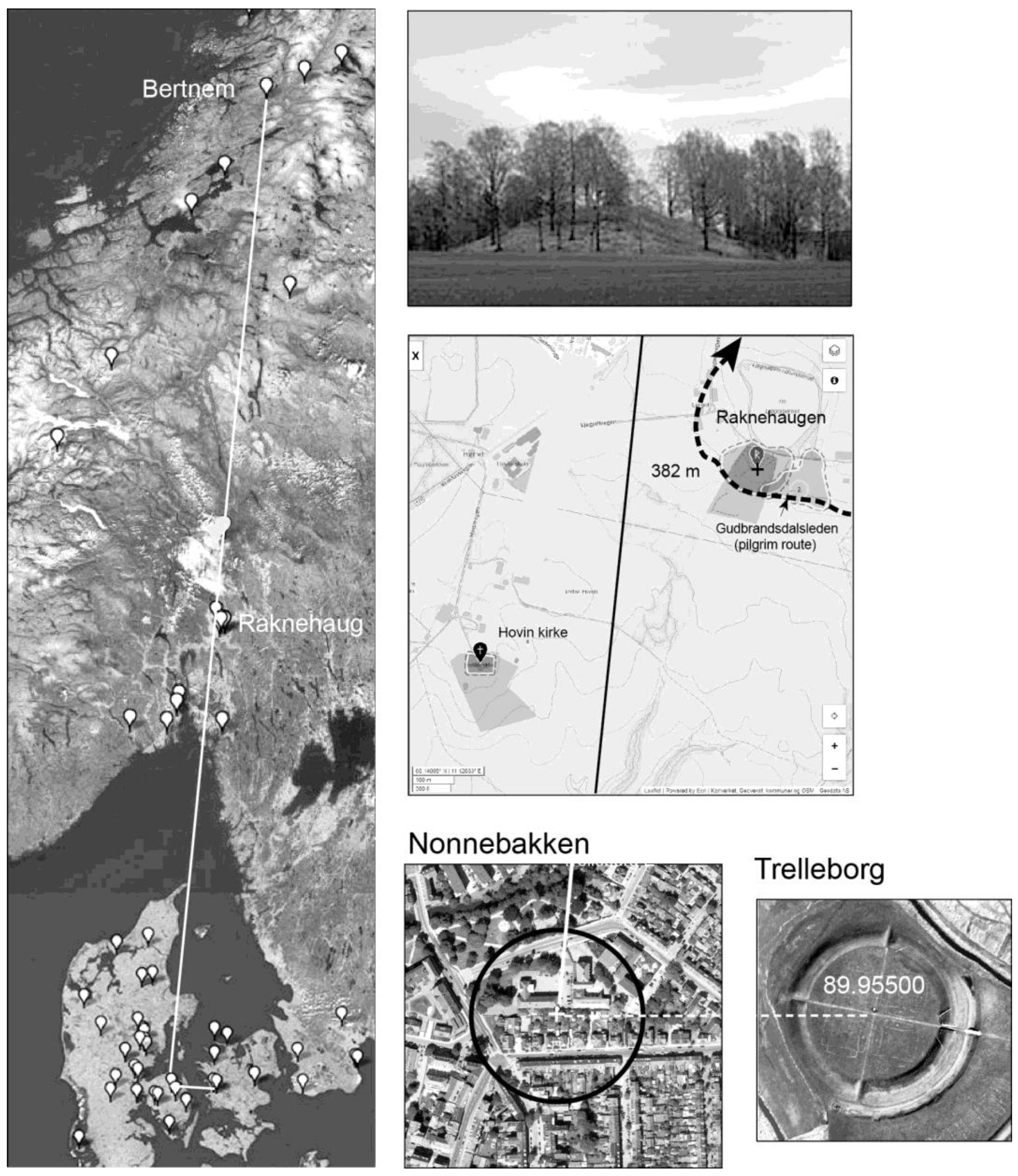
A second line locating Nonnebakken might have again involved Raknehaug, furthering ring borg associations with the Snøhetta cross axis. About two centuries later during the location and orientation of stone parish churches in Norwegian pilgrimages to St.Olav [6], Raknehaug’s meridian north coincides with the natural threshold point (Eidet) of Ytterøy island in Trondheimsfjord. Here it intersects with the axis from Frostating and Logtun running through the church of Maere up to the benchmark on the peak of Heimdalshaugen, most visible in Trondheimsfjord. This axis continues past the Eidet through the Straumen threshold at the apex of the “Yggdrasil” cross, Figure 19.
Earlier, Heimdalshaugen may have played a threshold role as the precise interim point on an alignment from what actually may be the largest mound site in Norway (three aligned 40-50 meter mounds), Bertnem, to Gudfjelløya, northern terminus of the SW – NE cross axis, Figure 17. The 69.729 km line from Gudfjelløya and Heimdalshaugen misses the middle of the center Bertnem mound by less than one meter; angular deviation an overly accurate 0.0003°. The first recorded source for “Tunnsjøguden” at Gudfjelløya is from 1723 describing a carved god figure as the “Tonsie Gud”, the focus of a cult site well known among the Sami. They left their reindeer alive, tethered near the ravine in the rocks for the gods to consume. The ravine on the top of the island is described in 1909 as possibly penetrating down to the level of the lake, so deep that it doesn’t freeze over in the winter. The Ostersunds-Posten (1953) describes a flat rock wedged in the cleft, on which offerings are left at solstice times (solverv). The ethnographer Manker’s own investigation of the island [38] describes the “sprickan” or crevasse as running in an east-west direction about 20 m at a width of from 20-50 cm. The depth could not be determined, but the sound of dropped stones reverberated for some time. He concludes that Gudfjelløya gives the highest convincing impression (of a natural sacred place) with its pronounced elevation and its “459 meter” rock face down into the lake.
Figure 17.
Precise alilgnment of line from Gudfjelløya through Heimdalshaugen benchmark o three mounds at the Bertnem farm.
Figure 17.
Precise alilgnment of line from Gudfjelløya through Heimdalshaugen benchmark o three mounds at the Bertnem farm.
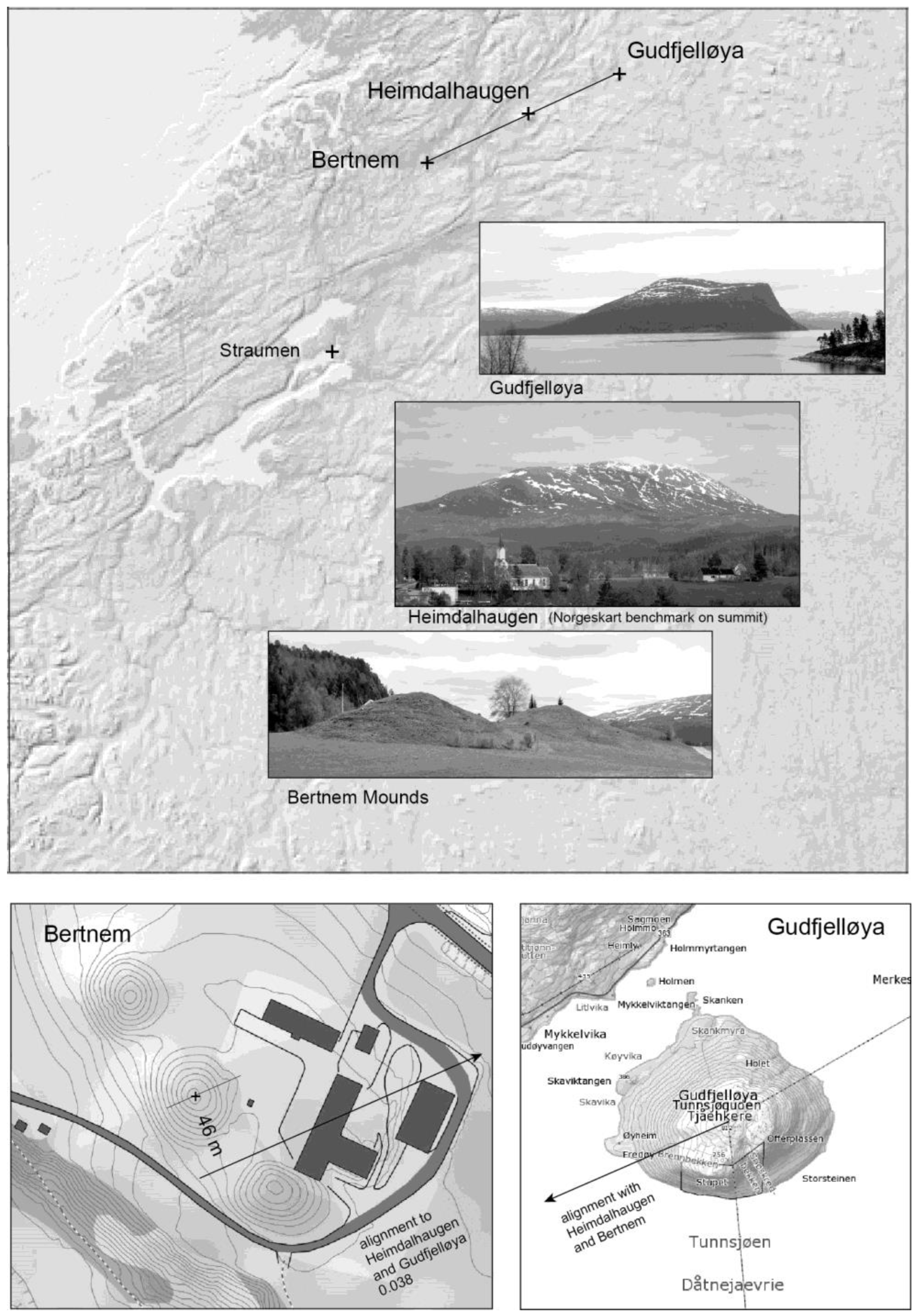
Bertnem, the Uppsala-like site from about 400-700 AD [32] contains the ruins of an unusually large longhouse 50 x 80 meters, contemporaneous with the mounds. Lack of clear funerary evidence suggests Bertnem as a pilgrimage destination. No simple seat of a powerful “king” of Namdalen, the longhouse resembles no others in the Trondheim region. It has Danish or English components, perhaps built by pilgrims worshiping a sacred Heimdalshaugen and Gudfjelløya. While not included in today’s popular pilgrimage routes, new close mapping of the Kystleden (coastal route) finds two long accurate alignments to Bertnem: one from Stavanger cathedral through Snøhetta, Vang gravefield (one of the largest in Northern Europe), and the Eidet; the other from the saga Sejle cult cave through Kvernes stavechurch and the large 43-meter mound of Ørland, on to Bertnem.
A surveyed line from Nonnebakken to Bertnem at 1,015.559 km would have been organizationally demanding among ring borg engineering. Not impossibly, a 10th century alignment from Raknehaug directly up to Bertnem might have existed, though pre-Olav pilgrims would have traveled mostly by ship up the Namsen fjord/river. A new total line might have been particularly symbolic for the ring borg “system”. Starting at Bertnem, considerable social participation could have supported the survey down to the Julton area and specifically Raknehaug. Continuing across the Skagerrak during a hard winter freeze, this three-point alignment has an average deviation of 0.04524°; with end points set at Bertnem and Nonnebakken, the line misses Raknehaug by about 382 meters.
One cannot orient Nonnebakken from published documents [33].
2.7. Fyrkat
Aside from Lembecksberg, the string of Nonnebakken, Trelleborg and Trelleborg E. forms a west-east line farther north from the Danevirke and the Kovirke alignment. And while the two Trelleborgs might have been linked to a developing overall pattern via a meridian with Borgring, systematic linkage might not have stopped east at Nonnebakken. It forms a remarkable addition to pattern associated with Hjortsballehøj, Figure 18. Assuming that Nonnebakken was positioned before Fyrkat, the very precise bisect vertex from Hjortsballehøj to Himmelbjerget creates an equivalent side ray that misses the Fyrkat center by about 18 meters. The deviation of the bisect is 0.006°. Together with the Hjortsballehøj pattern with Aggersborg and Lembecksburg, the Nonnebakken/Fyrkat bisect connects all ring borgs. The fact that the angles are less than a degree from 45° may not have been lost on designers.
Though only 14.334 km west of the considered largest mound in Denmark, Hohøj, Fyrkat wasn’t water related, its location requiring an additional azimuth besides the bisect ray. Here greatest symbolism and technical accuracy may overlap. The most spiritually powerful point in the “Yggdrasil” cross might not have been Julton, but the most northerly point on the meridian axis, Straumen, Figure 19. Most historically evident today is the medieval church of Saxhaug, wisely kept intact in 1871 after building a New Saxhaug. Much less known is the complex geometry of church locations and orientations in relation to the two 40-meter plus mounds flanking the strait.
Only a century ago Sakshaug parishioners located the new church very accurately on the late Iron Age alignment from Frostating (and adjacent Logtun church) thorough Maere to Heimdalshaugen. More significant, however, was the location, orientation and interior layout of the 1184 stone church. It integrates with a perhaps ancient bisect pattern from a large “bygdeborg” to the two strait mounds. Its nave axis forms a bisect vertex to the center of the strait (mound determined) and the two interior pillars flanking the altar.
In the middle of the 10th century, only a few decades before King Olav was martyred beside Trondheimsfjord--on the same latitude as the Raknehaug and Heimdalshaugen related Eidet threshold—master Viking builders may have designed a Jelling connection to Straumen, using the rhombus palisade orientation and Fyrkat location as intermediary along with Himmelberget. The very short distance from Fyrkat to Himmelberget, 57.928 km, compared to that from Fyrkat to Straumen, 811.598 km, seems a huge undertaking, though again linkage from Straumen to Himmelbjerget (and Jelling) could have been extremely symbolic. The Straumen – Fyrkat – Himmelbjerget line has an average deviation of 0.02851°, missing the Fyrkat center point about 54 meters to the east.
Figure 18.
Bisect vertex from Hjortsballehøj to Himmelbjerget with rays to Nonnebakken and Fyrkat completes integration of all ring borgs; second line to position Fyrkat aligns with Himmelbjerget and Straumen.
Figure 18.
Bisect vertex from Hjortsballehøj to Himmelbjerget with rays to Nonnebakken and Fyrkat completes integration of all ring borgs; second line to position Fyrkat aligns with Himmelbjerget and Straumen.
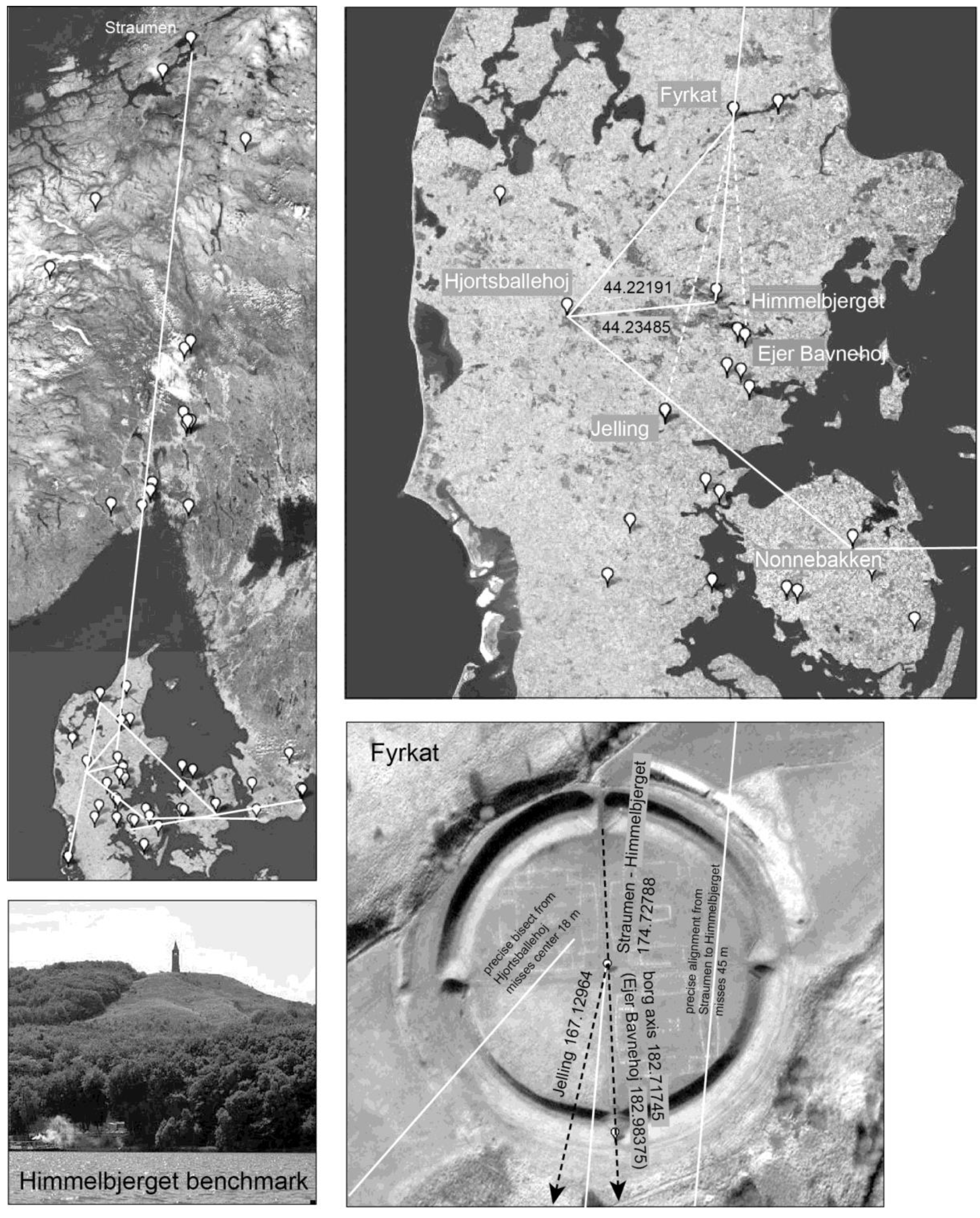
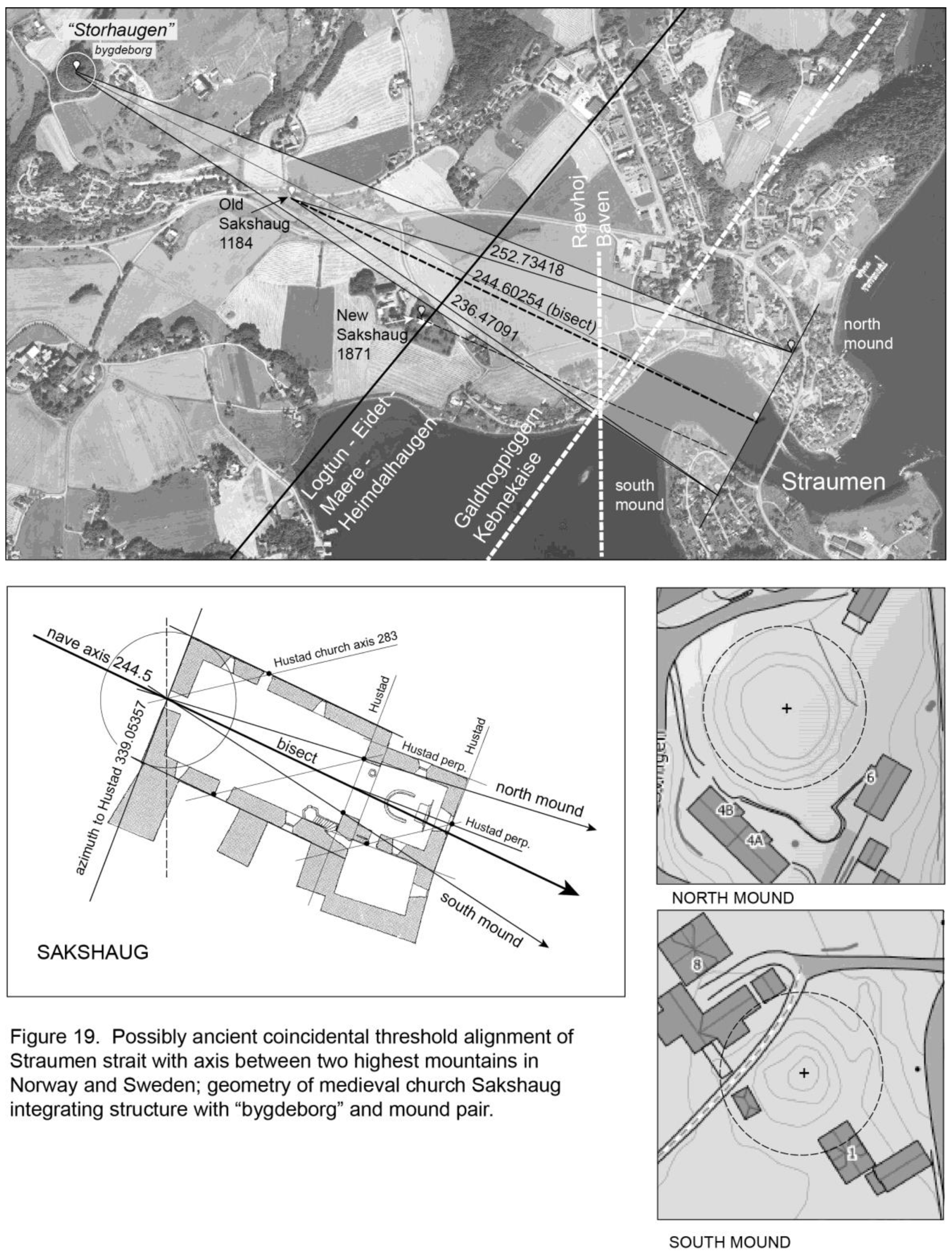
Mapping from satellite images measures Fyrkat’s “north-south” axis as 182.71745°. The closest azimuth south is the modern highest point in Denmark, Møllehøj 182.77035° (Ejer Bavnehøj 182.98375, Yding Skovhøj 181.27601). Using the two azimuths from Fyrkat’s center to Himmelbjerget and Jelling one determines a logical ideal bisect accuracy. The azimuth to Jelling, and the orientation of its two rhombus palisade sides, is again 167.12964°, and to Himmelbjerget 174.72788°, giving a bisect of about 7.59824°, and a precise eastern ray of 182.32612°, compared to the measured site axis of 182.71745° off about 0.4°
No eastern ray of this bisect may have extended south, perhaps avoiding symbolic dissonance pairing with Jelling across the Himmelbjerget – Straumen line as bisect vertex. The possible error in Fyrkat’s orientation might have been caused either by an inaccurate present measure without professional sun shots, or more simply that a time lag existed between the positioning of Fyrkat, and the layout of its cross axes.
3. Discussion: Ring Borgs as Pattern of Systemic Integration and Possible Linkage to Yggdrasil as Map?
The geometric layout of ring borg locations and five orientations in Figure 20 does not claim to have proven all elements as designed. Any accurate element—alignments, cardinals and right angles—could be coincidental. More important, however, and more difficult to statistically test, are patterns of elements that suggest some overall systematic concept:
Figure 20.
Ring borg locations and orientations as system (left); egalitarian layout of dwellings in Trelleborg representation.
Figure 20.
Ring borg locations and orientations as system (left); egalitarian layout of dwellings in Trelleborg representation.
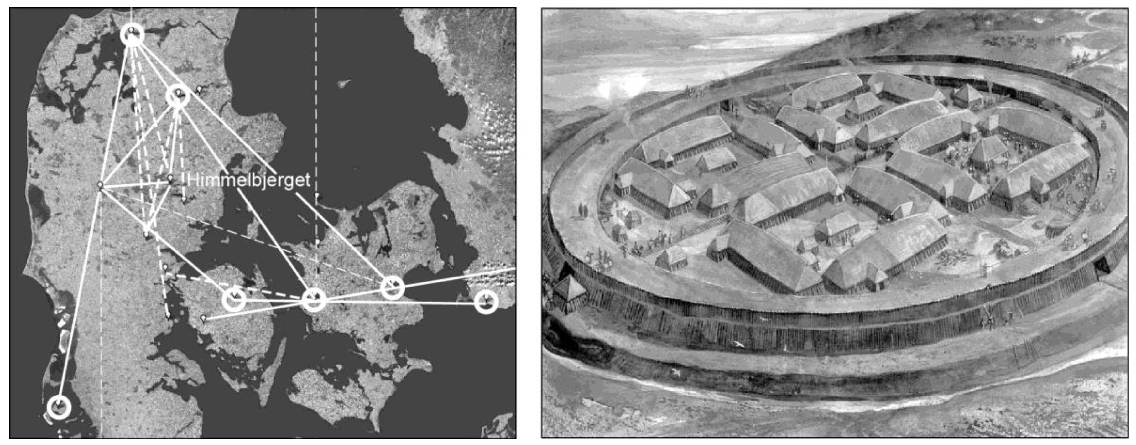
At the level of patterns, possibly defined are two primary territorial lines or edges to the “system”, one from the largest and most northerly Aggersborg, down to the smallest Lembecksberg. The second may have replicated the Danevirke with Nonnebakken, Trelleborg and Trelleborg E. running west-east. Connecting these two lines is the bisect from the junction point of the vertical line, Hjordsballehøj, to Himmelbjerget, with rays to Nonnebakken and Fyrkat. Borgring’s territorality may be related to the Øresund; its linkage to the system relying on its axis involving the 45° to Aggersborg, and the transported angle from Hjortsballehøj to Himmelbjerget and Aggersborg. Borgring’s location also connects to the east-west line through a bisect from a meridian perhaps used to originally position it, Figure 15, to the two Trelleborgs; the precise bisect azimuth at Borgring 179.88594°.
Strongly indicating design, Lembecksburg’s site orientation agrees with its azimuth to Aggersborg. Design pattern at the pivotal Hjortsballehøj also seems very likely at the bisect to Himmelbjerget with rays connecting Fyrkat and Nonnebakken. How could Hjortsballehøj coincidentally work with positioning of six of the seven borgs, even possibly the seventh, considering Borgring’s cross axis? Architecturally persuasive as well are the two pairs of large-scale azimuths that locate Trelleborg and Borgring, working geometrically to create their cross axis orientations, one azimuth in each running to Aggersborg.
Given the architectural likelihood that much of this layout was designed and laid out by master surveyors, did the system socially influence primarily by territorial power, considering that Danes, and other Scandinavians working and living there [19] may have conceptualized the total layout? Assuming that Aggersborg’s location was determined primarily by the need for water access, and that Hjortsballehøj was an earlier religious element with its meridian down to Externsteine, how might the spiritual power of Himmelbjerget played into to the system? Pattern links to Aggersborg and Fyrkat seem clear, as is the monumental flow of spirituality from the Jelling ship setting to Himmelbjerget that include the “framing” orientations of the two rhombus palisade azimuths. But was this the limit of Danish landscape spirituality? How did Himmelbjerget connect to Nonnebakken, Trelleborg, Borgring, and Trelleborg E?
Even if Himmelbjerg had been religiously vital to at least part of the layout, the system still would remain a seemingly territorial enterprise with primarily military purpose—even without water access for almost all borgs. Most important, however, may be the recognition that the Danish system strongly implies the existence of master surveyors. This it is not necessarily illogical to search for connections to more powerful Norse spirituality that could have motivated participation from wider Scandinavia.
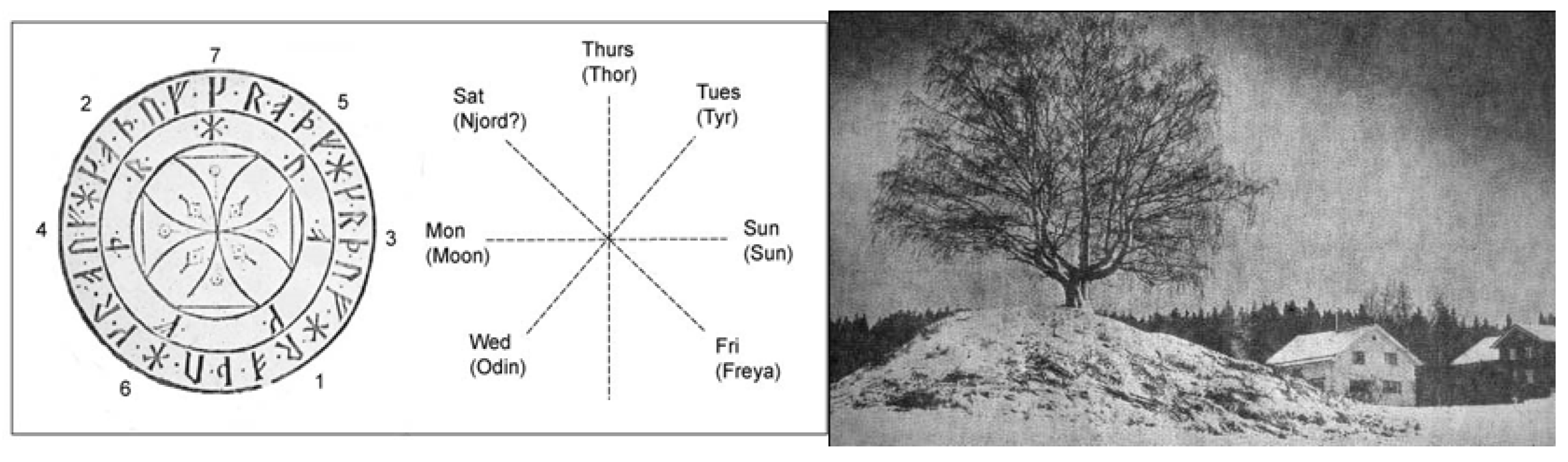
At architectural scale, ring borgs reveal little hierarchy or territoriality, no ranking is evident between occupying families (for such traditions of Scandinavian cooperative work and living settings see [35] (Intro Chapter). The meaning of the opposed directions of long houses may be similar to patterns on Scandinavian farms in pre-Viking Iron Age and the Medieval, whether on Gotland, Iceland or the valleys in Norway—see chapter IV [1]. In Norway one direction meant social cooperation (stue) and the other competition (loft). Lindström’s ideas of systematic right-angled grave orientations in Scandinavia are interesting here [36]. Yet at farm scale dwellings were symbolically defined as related to the hierarchical family, opposed to some natural spiritual feature where the spirit of the farm lived, [1] Figure 21. Thus, if one considers the ring borgs as “dwelling” they should be spatially and symbolically opposed to natural features in the landscape.
Figure 21.
“Tun” tree and prehistoric burial mound from Hammar, Norway (Aftenposten Dec. 8, 1976 (photo); Olaus Worms’ 17th century reproduction of a Swedish runstave from the 1300’s [34]; seven runes on inner circle designate days of the week, their sequence creates a spatialized cross structure of time with Thor’s day as the vertical axis mundi.
Figure 21.
“Tun” tree and prehistoric burial mound from Hammar, Norway (Aftenposten Dec. 8, 1976 (photo); Olaus Worms’ 17th century reproduction of a Swedish runstave from the 1300’s [34]; seven runes on inner circle designate days of the week, their sequence creates a spatialized cross structure of time with Thor’s day as the vertical axis mundi.
The spiritual power of the ancient Scandinavian landscape, e.g., Himmelbjerget, Snøhetta, Straumen, Raknehaug, Bertnem, Hjortsballehøj, Buskehøj and even Externsteine has probably too long been misrepresented, particularly interpreting large mounds as expressions of territorial power and big men. Even without considering the possibility of prehistoric mound location in sacred Scandinavian frameworks one can see archaeological reinterpretations of the overall funeral process in a more Norse socio-spatial context. Looking closer at the ritual sequence at Lusehøj near Voldtofte outlined by Svanberg [39], one sees a strong symbolic statement about the relationship between hierarchies, whether of chiefs or ordinary “husbonder”, and collectivities. Goldhahn’s excavation of a 20 meter “storhog” at Sagaholm, south of lake Vättern, Sweden [40,41], describes a related tripartite horizontal structure of concentric rings interpreted as organizing a ritually used, liminal sequence. The ritual climax occurs as the competitive or authoritarian element (dwelling) is covered up by its symbolic opposite, a large mountain of earth requiring cooperative labor to construct.
What if then, the ring borg system, though laid out defensively to the south, intended to collect spiritual energy from an older large-scale, still extant, landscape system -- this to silently gird or frame the imminent addition of new hegemonic Christianity, as seen most clearly in the accommodating location of the Aggersborg church (which likely replaced a more disposable wooden one). While the linkage of ring borgs to points in Yggdrasil as Map logically cannot be as systematic, patterns can be described beyond accurate large-scale elements.
Most suggestive is Aggersborg’s location on a meridian to what historically was considered central and southern Scandinavia’s most visually prominent mountain, Snøhetta – northern terminus of the NW – SE cross axis. Combining at Hjortsballehøj with a precise meridian down to Externsteine, via the oriented alignment with Lembeckberg clearly expresses the spirituality of most prominent mountains and North-South meridians or axes mundi. Why is the largest of borgs most northerly in Jutland, particularly if water access was also not an important locator? In addition to Trelleborg and Borgring’s 45° site orienting lines to Aggersborg, a cross related surveyed line from Snøhetta down through Gjellestad could have framed the full eastern extent of the system to Trelleborg E.
Figure 22.
Possible surveyed lines to Yggdrasil cross points from all ring borgs except Lembecksburg.
Figure 22.
Possible surveyed lines to Yggdrasil cross points from all ring borgs except Lembecksburg.
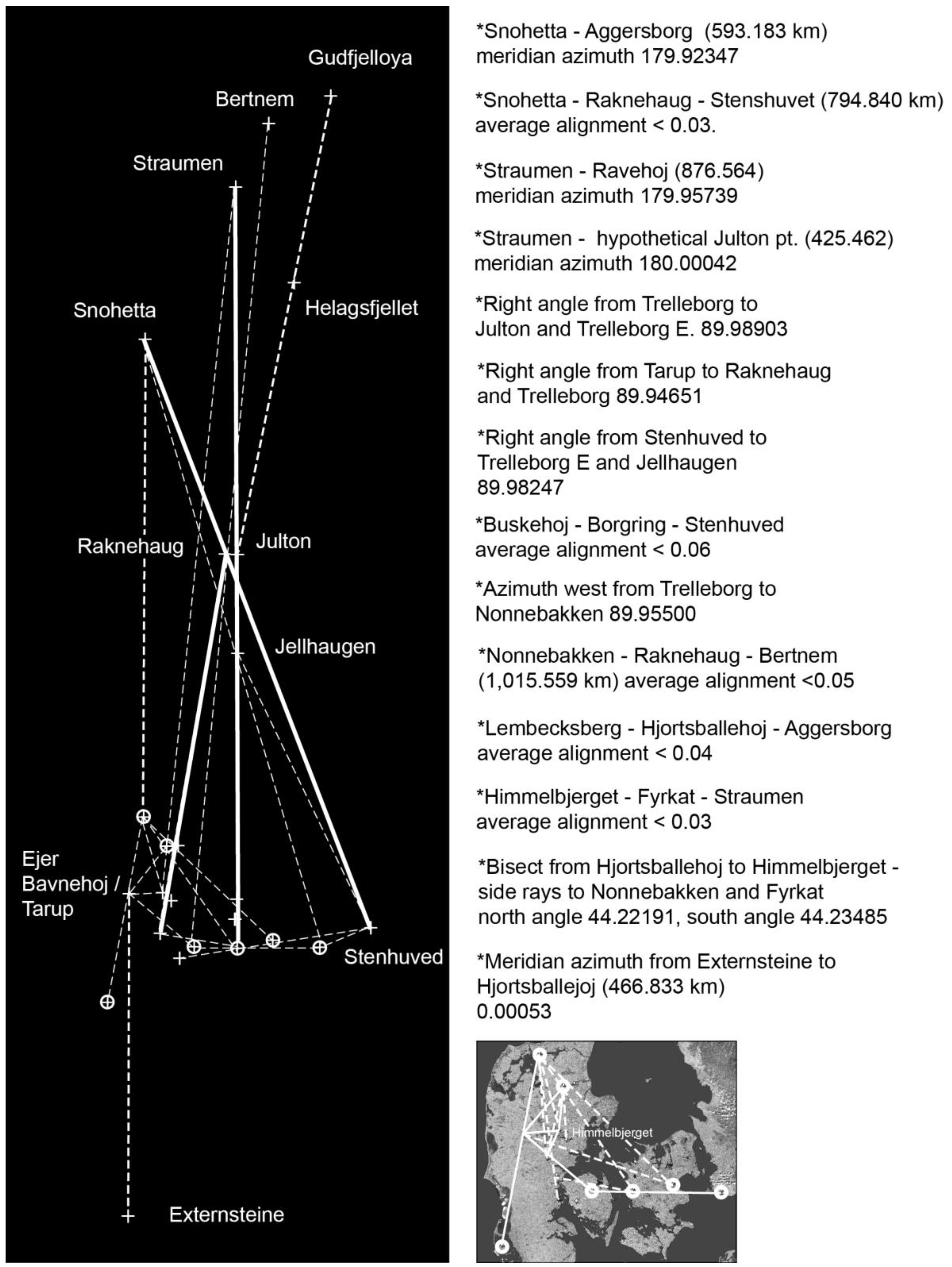
Contrary to Yggdrasil’s NE - SW cross axis as it runs down through Hohøj and a highest point in Denmark, ring borg emphasis of Snøhetta’s role as northern terminus of the opposite SE – NW axis, may have been politically motivated. Snøhetta’s aligned center mound, Raknehaug (to Stenhuved) may have cemented the preference of this axis. Raknehaug provides a central Yggdrasil location for Trelleborg, as well as an interim point for a Nonnebakken - Bertnem line which ultimately may have ritually connected to the terminus of the NE - SW cross axis and Gudfjelløya. The right angle of the two Trelleborgs up to a hypothetical Julton point on the central Yggdrasil meridian may be less probable. But the line from Himmelbjerget slicing through the Fyrkat ring, on to Straumen symbolically connects the power of the Jelling site orientation to the climax threshold of all three cosmic tree axes.
To a certain extent possible large-scale elements surveyed by designers to help locate ring borg centers define the principal points of Yggdrasil cross pattern, particularly using Raknehaug as the primary center element. This symbolism becomes quite clear in the tested pattern of the Gudbrandsdal medieval pilgrimage to sacred sites in Trondheimsfjord, above all the Eidet threshold as Raknehaug meridian terminus on the axis from Frostating/Logtun to Heimdalshaugen, the threshold between Bertnem and Gudfjelløya [6].
References
- Doxtater, D. The Symbolism, Structure and Politics of “Center” in the Old Scandinavian Farm Culture. Dissertation: University of Michigan, Ann Arbor 1981.
- Dilke, O.A.W. The Roman Land Surveyors. Newton Abbot: David & Charles. 1971.
- Lekson, S. The Chaco Meridian. Altimira Press, Walnut Creek 1999.
- Gallo, I.M. Roman Surveying. Proceedings of the European congress “Las Obras Públicas Romanas”. Tarragona, Spain 2004.
- Doxtater, D. Mesoamerican Pyramidal Shaped Landscapes as Maps in Urban Ceremonial Sites: “Close Mapping” Analysis of Spatial Homologs. intechopen.com 2024.
- Doxtater, D. Close mapping of St. Olav’s Pilgrimage path through Gudbrandsdal Norway: probabilities of a designed, land surveyed concept of a large-scale Christianized landscape. International Journal of Religious Tourism and Pilgrimage 2023, 11, 83–117. [Google Scholar]
- Doxtater, D. Pilgrimage to the “Vi” Center of Bulverket’s Water Square: the Location and Orientation of Gotland Churches. In Experiences, Advantages, and Economic Dimensions of Pilgrimage Routes, Vitor João Pereira Domingues Martinho, João Lucia de Jesus Pato, Liliana Andrade de Matos, Augusto Guerra da Rocha Nunes, Maria Castilho, eds. IGI Global, 2023. pp 143-190.
- Doxtater, D. Land surveying in early medieval Norway: a St. Olav pilgrimage means of creating an integrated Christian society in a Viking landscape? Landscape Research. Published online 21 November 2022. [CrossRef]
- Doxtater, D. Probabilities of designed locations of ceremonial foci: the Chaco Meridian, temple IV at Tikal, and a large-scale sacred Adena river landscape. Time and Mind. 2021, 14, 283–326. [Google Scholar] [CrossRef]
- Doxtater, D. A Report on Geopatterns Software: describing and analyzing large-scale geometry between Chacoan and natural sites. In Jeffrey T. Clark and Emily M. Hagemeister, Editors. Digital Discovery: Exploring New Frontiers in Human Heritage. CAA 2006. Computer Applications and Quantitative Methods in Archaeology, 2007. [Google Scholar]
- Doxtater, D. Rethinking the Sacred Landscape: Minoan Palaces in a Georitual Framework of Natural Features on Crete. Landscape Journal Vol. 28-1, Spring, 2009. 1-21.
- Wilbert, J. Mystic Endowment: Religious Ethnography of the Warao Indians. Harvard University Center for the Study of World Religions 1993.
- Goodchild, H. Holm, N. & Sindbæk, S.M. Borgring: the discovery of a Viking Age ring fortress. Antiquity 2017, 91, 1027–1042. [Google Scholar]
- Ulriksen, J. Mortensen, Schultz, M. F. Dominating the Landscape – the emblematic Setting of Borgring and the Viking Age Ring Fortresses of Denmark. Danish Journal of Archaeology 2020, 9, 1–22. [Google Scholar]
- Hald, M.M. Jessen, C. Henriksen, P.S. & Ulriksen. J. (). The lost landscape of Borgring: geoarchaeological investigations into the navigation to, and location of, the Danish Viking Age ring fortress. Danish Journal of Archaeology 2021, 10, 1–14. [Google Scholar]
- Wellendorf, J. Homogeneity and heterogeneity in Old Norse cosmology. In Andrén, Anders; Jennbert, Kristina; and Raudvere, Catharina (eds) Old Norse Religion in Long-Term Perspective. Lund: Nordic Academic Press 2006.
- Hastrup, K. Culture and History in Medieval Iceland. Oxford: Clarendon Press 1985.
- Storaker, J. T. Elementerne. Kristiania (Oslo): Norske Folkeminnelag 1924.
- Price D., T. , Frei K.M., Dobar A. S., Lynnerup N., Bennike P. (). Who was in Bluetooth’s army? Strontium isotope investigation of the cemetery at the Viking Age fortress at Trelleborg, Denmark. Antiquity 2011, 85, 476–489. [Google Scholar] [CrossRef]
- Meletinskij, E. (). Scandinavian Mythology as a System, I & II. Journal of Anthropology, No. 1 & 2. 1973.
- Dumezil, G. Gods of the Ancient Northmen. Berkeley: University of California Press 1973.
- Söderman, I. Från lertavla till satellitbild. Uppsala: Geographica 1989.
- Danish archaeological interactive map. https://slks.dk/english/work-areas/cultural-heritage/sites-and-monuments/register.
- Treude, E.; Zelle, M. Externsteine (German). Lippischer Heimatbund, 2012. pg. 46-48.
- Murphy, G. Ronald, SJ. (). The Extersteine Relief of the Deposition from the Cross: A Germanic-Christian Interpretation in the light of the Heliand and the Elder Edda. Worship 2020, 94, 346–355. [Google Scholar]
- Murphy, G. Ronald Tree of Salvation: Yggdrasil and the Cross in the North. UK: Oxford 2013.
- Andrén, A. I skuggan av Yggdrasil. In A. Andrén, K. Jennbert, and C. Raudvere (eds) Ording mot kaos. Vägar to Midgård 4: 2004. 389-430. Lund: Nordic Academic Press.
- Horgen, J. E. Sørum Bygdebok, Vol. 1. Sørum Kommune 2003.
- Henriksson, G. The pagan Great Midwinter Sacrifice and the ‘royal’ mounds at Old Uppsala. In Blomberg, M, Blomberg, P. and Henriksson G. (eds), Calendars, Symbols, and Orientations: Legacies of Astronomy in Culture. Uppsala: Uppsala Astronomical Observatory Report No. 59 2003.
- Pcisztor, E. & Roslund, C. Orientation of Danish geometrical Viking fortresses. In Oxford VI and SEAC 99 “Astronomy and cultural diversity”, Cesar, E. & Belmonte, J. A. editors, 1999. pp. 65 – 70.
- Gustavsen, L. Gjesvold, P.E.Per Erik, Gundersen, S.M. Hinterleitner, A. Nau1, E. & Paasche, K. Gjellestad: a newly discovered ‘central place’ in south-east Norway. Antiquity 2020, 94, 1520–1537. [Google Scholar]
- Farbregd, O. Perspektiv på Namdalens jernalder. Viking XLIII. 1979 Oslo.
- Runge, M. New archaeological investigations at Nonnebakken. Jesper Hansen & Mette Bruus editors, The fortified Viking Age: 36th interdisciplinaryViking Symposium. Odense, 2018. pp. 44–59.
- Brynjulf, A. Dag Og Merke. Oslo: Universitetsforlaget 1970.
- Doxtater, D. “The Spatial Basis of Swedish History.” (chapter 1) Architecture, Ritual Practice and Co-determination in the Swedish Office. Routledge, 1994, 2025, 18–51.
- Lindström, Jonathan. . The Orientation of Ancient Monuments in Sweden: A Critique of Archaeoastronomy and an Alternative Interpretation. Current Swedish Archaeology 1997, 5, 111–125. [Google Scholar]
- Lindström, Jonathan. . Påsk, höstblot och jul: sambandet mellan årliga högtider och forntida gravars orienteering. Fornvännen 2005, 100, 13–28. [Google Scholar]
- Manker, E. Lapparnas Heliga Ställen. Nordiska Museet: Acta Lapponica, Uppsala:Almqvist & Wiksells 1957.
- Svanberg. F. House symbolism in aristocratic death rituals of Bronze Age. In Artelius, T. &Svanberg, F. (eds) Dealing with the dead. Archaeological perspectives on prehistoric Scandinavian burial ritual. Riksantikvariea Ämbetets Arkeologiska undersökningar. Skrifter no. 65. Stockholm. 2005. pp. 73–98.
- Goldhahn, J. Sagaholm. Studia Archaeologica Universitatis Umensis 11. Jönköpings Läns Museums Arkeologiska Rapportserie 41 1999.
- Goldhahn, J. Från Sagaholm till Bredarör—hällbildsstudier 2000-2004. Gotarc Serie C. Arkeologiska Skrifter No. 62. Göteborg 2005.
Disclaimer/Publisher’s Note: The statements, opinions and data contained in all publications are solely those of the individual author(s) and contributor(s) and not of MDPI and/or the editor(s). MDPI and/or the editor(s) disclaim responsibility for any injury to people or property resulting from any ideas, methods, instructions or products referred to in the content. |
© 2025 by the author. Licensee MDPI, Basel, Switzerland. This article is an open access article distributed under the terms and conditions of the Creative Commons Attribution (CC BY) license (https://creativecommons.org/licenses/by/4.0/).
Copyright: This open access article is published under a Creative Commons CC BY 4.0 license, which permit the free download, distribution, and reuse, provided that the author and preprint are cited in any reuse.


