

Submitted:
17 March 2025
Posted:
18 March 2025
You are already at the latest version
Abstract
Urban greenery and cooling initiatives have become top priorities for municipalities worldwide, as they contribute to improved environmental quality and urban resilience. This study leverages advancements in remote sensing (RS) and cloud-based processing to assess and monitor changes in public urban green spaces (PUGS) in Sanandaj, Iran. Using high-resolution Sentinel-2 imagery (10 m) processed in Google Earth Engine (GEE), we calculated and mapped the normalized difference vegetation index (NDVI) across 20 major PUGSs over a five-year period from 2019 to 2023. A total of 507 Sentinel-2 images were analyzed, offering a comprehensive view of seasonal and annual greenness trends. Our findings reveal that May is the peak month for greenery, while February consistently shows the lowest NDVI values, indicating seasonal greenness variability. Specifically, the mean NDVI of PUGSs decreased significantly between 2019 and 2022, with values recorded at 0.735, 0.737, 0.622, 0.417, and 0.570 in the greenest month of each respective year, highlighting a noticeable decline in vegetation health and extent. This reduction can be attributed to water scarcity and suboptimal management practices, as evidenced by dried or underperforming green spaces in recent years. Our results underscore the potential of integrating NDVI-based assessments within urban development frameworks to more accurately define and sustain PUGSs in Sanandaj. This methodology provides a replicable approach for cities aiming to optimize urban greenery management through RS technology.
Keywords:
environmental health
; urban green spaces
; remote sensing
; google earth engine
; sentinel-2 imagery
; NDVI
; urban greening
; climate adaptation
1. Introduction
In recent decades, rapid urbanization has led to over half of the world’s population living in urban areas [1]. Cities encompass various land uses—such as residential, educational, and commercial spaces—that significantly influence environmental quality [2,3]. However, urban areas often act as focal points for global warming and contribute to the urban heat island (UHI) effect, a phenomenon when urban centers are warmer than surrounding rural areas [4]. The UHI effect is particularly severe in cities with limited vegetation, amplifying environmental issues like air pollution [5], urban flooding [6], and increasing temperatures, which diminish climate resilience [7,8]. Urban green spaces (UGS) play a crucial role in urban planning by mitigating these effects, reducing air pollution, aiding flood management, and enhancing residents' well-being, including better sleep quality and academic performance [9,10,11,12,13,14,15,16,17]. Given their importance, conserving urban vegetation is critical [18], especially as unplanned urbanization and conversion from green to grey spaces, prevalent in developing countries like Iran, severely degrade natural resources [19].
As urban greenery benefits the social, physical, and environmental health of cities [20], its preservation has become a priority for local governments [21]. Monitoring UGS dynamics is essential for effective urban planning and contributes to achieving the United Nations Sustainable Development Goal 11 (SDG 11), which seeks to make cities inclusive, safe, resilient, and sustainable by 2030 [22,23]. This need is particularly pressing in arid and semi-arid regions, where vegetation lowers ambient temperatures [24] and enhances carbon sequestration [25].
Landscape vegetation in UGSs consists of diverse species of trees, shrubs, and grasses, creating varied microclimates [26]. Monitoring green space changes demands detailed landscape knowledge and reliable data sources [27]. In-situ measurements, while useful, are often impractical in developing countries due to high costs and time requirements [28,29,30]. RS technologies offer a cost-effective solution for monitoring urban greenness, providing comprehensive and repeatable data collection for urban vegetation analysis [31,32]. RS enables efficient mapping of urban vegetation patterns, a vital need in resource-limited settings such as Iran [33]. Among various RS methods, the normalized difference vegetation index (NDVI) is widely adopted to quantify vegetation health and greenness, proving useful for assessing ecological responses, soil conservation, and monitoring urban development, among other applications [31,34,35,36,37,38,39,40,41,42,43,44,45,46].
In recent years, several satellite platforms, including Landsat, WorldView, and Sentinel, have been used to monitor UGSs, allowing for large-scale assessments and detailed spatial analysis [47,48,49,50]. Research has shown the value of studying UGSs at different temporal and spatial scales, revealing insights into the distribution and impact of green spaces within cities. For example, studies have demonstrated that unplanned urban expansion can fragment green spaces, reducing ecological connectivity [22,27,33]. Furthermore, spatial analyses suggest that the benefits of UGSs may vary seasonally, with green areas providing cooling benefits primarily in warmer months, as observed in studies of urban cooling islands (UCI) [51,52].
This study is distinct in its focus on multi-temporal analysis of large parks (over 10,000 m2) in Sanandaj, using high-resolution Sentinel imagery over a five-year period (2019-2023) to capture seasonal, monthly, and annual greenness variations. Sanandaj’s low per capita green space (~5 m2, compared to the WHO recommendation of 9 m2) poses environmental challenges that necessitate strategic planning.
The novelty of this research lies in conducting over five years at different temporal scales (monthly, seasonally, yearly) for the large parks (>10,000 m2) separately using high-resolution satellite data i.e. Sentinel. It gives more details about the greenery of Sanandaj and it contributes to the comparison between the quality of greenness of different UGSs.
The primary aim of this research is to assess the vegetative health and greenness of PUGSs in Sanandaj, to mitigate the UHI effect and enhance urban thermal comfort. Specifically, this study seeks to analyze changes in greenness across public urban green spaces (PUGS) in Sanandaj from 2019 to 2023, categorize these spaces based on their cooling effectiveness, and develop actionable strategies for municipal authorities to help reduce UHI impacts. To achieve these objectives, the study explores which months demonstrate the highest and lowest greenness, identifies which PUGSs have minimal cooling effects on their surroundings, and evaluates the extent to which these spaces contribute to improved thermal comfort. Additionally, strategies to enhance the cooling impact of UGSs and improve urban livability in Sanandaj are proposed.
2. Study Area, Methods, and Data Sources
2.1. Study Area
This research was conducted in Sanandaj, the capital city of Kurdistan province, Iran (Figure 1a). As the largest city in the province, Sanandaj has a population of approximately 450,000 [53]. According to the De Martonne and IRIMO (I.R. of Iran Meteorological Organization) methods, the city has a semi-arid climate with moderate rainfall [52]. Between 1992 and 2023, the highest annual precipitation in Sanandaj reached 645 mm in 1994, while the lowest recorded was 166 mm in 2021. Over this period, the mean annual precipitation of Sanandaj was approximately 370 mm (Figure 1b).
As shown in Figure 1c, the long-term maximum monthly mean temperature in Sanandaj fluctuated widely between 1992 and 2023. According to data from the IRIMO, the hottest month occurred in July 2018, with a temperature of 30.06°C, while the lowest maximum monthly mean temperature was recorded in July 1992, at 26.62°C. Moreover, based on the long-term data (1992-2023), the dry season in Sanandaj spans from May to the end of September (Figure 1d).
2.2. Data Sources
In this study, we selected 20 PUGSs in Sanandaj (Figure 2) based on specific criteria derived from three primary sources: Google Earth Engine (GEE), the Sanandaj Detailed Urban Plan (SDUP), and expert judgment. GEE is a cloud-based platform recognized as a multidisciplinary tool with diverse applications across various fields, particularly in vegetation monitoring [54,55]. These criteria are related to two factors:
- (i)
- Area: For classifying the PUGSs according to their area, we defined three categories: Small PUGSs (with an area greater than 0 and up to 100 m2), Medium PUGSs (with an area greater than 100 m2 and up to 10,000 m2), and Large PUGSs (with an area greater than 10,000 m2). In this research, we focused on selecting only the PUGSs categorized as "Large" (i.e., with an area greater than 10,000 m2). In a city like Sanandaj, large green spaces have a substantial impact on the overall greenness, making them representative for studying urban greenness. By evaluating these large parks, we can derive meaningful insights into the changes in greenness across the entire city.
- (ii)
- Function of Parks: Although the SDUP designates several large lots (larger than 10,000 m2) as parks, expert evaluation determined that some of these spaces should not be classified as PUGSs in this study. This exclusion was due to two main reasons: first, the functions of certain "parks" differ significantly, such as those designated as cemeteries; second, some of these areas lack vegetation (trees or grass), making them more similar to vacant lots than functional green spaces.
2.3. Satellite Data
To obtain urban greenery data for the 20 selected PUGSs in Sanandaj from 2019 to 2023, RS techniques were employed across multiple temporal scales (monthly, seasonal, and yearly) at a high spatial resolution. A total of 507 Sentinel-2A images were extracted and corrected using GEE platform [56] for this analysis. To do so, cloud, shadow, and snow removal was applied to the images. Table 1 provides a breakdown of the number of Sentinel-2A images available for each year within the study period. Urban greenery data were derived using the NDVI, a vegetation index, to assess vegetation health and coverage. The choice of Sentinel-2A imagery was based on two key reasons: (i) it offers imagery with a spatial resolution of 10 meters, which is well-suited for detecting changes in greenness at the city level, and (ii) in addition to monitoring vegetation growth, it is effective in mapping land cover changes [57].
2.4. Extracting NDVI Maps
During the period 2019–2023, monthly, seasonal, and annual NDVI values were calculated using Sentinel-2A images at a spatial resolution of 10 m. The NDVI can be calculated as:
NDVI = (NIR – RED) / (NIR + RED)
After applying various masks and corrections (for cloud, shadow, and snow) to the Sentinel images on the GEE platform, the maximum NDVI maps were extracted. Based on the method by Aryal et al. [21] and an observational approach, pixels with an NDVI value ≥ 0.4 were considered PUGSs (Figure 3), which are ecologically capable of mitigating the UHI effect and improving the surrounding environment. Visualization of the results were conducted in Quantum Geographic Information System (QGIS) [58].
2.5. Defining Dynamic and Static Borders for PUGSs
Regarding the borders of the PUGSs, greenery in Sanandaj can be evaluated in two different ways: (i) using a dynamic border (DB) during the study period (for assessing drought and the lack of water resources to irrigate PUGSs); (ii) using a static border (SB) over the five years of the study (for calculating the NDVI of the PUGSs, estimating Evapotranspiration (ET) of PUGSs, and analyzing changes in greenness during a specific period). Therefore, to assess the greenness of PUGSs comprehensively, it is important to have a clear definition of their borders. In the first case (DB), the border of each PUGS for each year is determined by using the greenest month in that year. To do so, the maximum NDVI map of the greenest month in a year is extracted in GEE by applying the maximum value composite (MVC) [39], and then pixels with NDVI < 0.4 are removed from the map. Finally, the resulting map is defined as the border of the PUGS in that year. In Sanandaj, this DB varies from one year to another. On the other hand, to determine an SB for each PUGS, we extracted the maximum NDVI map for each PUGS over the five years of the study period, and then we excluded pixels with NDVI < 0.4 from the map. The result is considered the SB of the PUGS for all years of the study period.
2.6. Visual Language for Tracking Changes in Greenness
Cartographic representation of changes in greenness in cities provides useful information for local governments to make clear policies regarding urban greenery. To map changes in greenness in 20 PUGSs, we used the PUGS Anomaly Map (PUGSAM) for each year. Over the five years of the study, the PUGSAM for one year (e.g., 2019) was calculated as follows:
PUGSAM2019 = NDVI map 2019 – X
2.7. Classifying UGSs to Analyze Urban Greenery
To assess greenness in urban areas, it is crucial to distinguish urban parks, as each PUGS has a different impact on the environment. Based on field observations, in Sanandaj, we found that there are different types of PUGSs according to the major landscape and type of irrigation. Among the 20 PUGSs in this research, there are 5 forest parks and 15 urban parks. The irrigation system of urban parks is the Full Irrigation System (FIS), and for watering forest parks, the Sanandaj municipality uses the Supplementary Irrigation System (SIS). According to major landscapes, the selected parks are divided into two groups: MG (mostly covered with grass) and MT (mostly covered with trees) (Table 2).
3. Results
3.1. Monthly Mean NDVI of PUGSs in Sanandaj (2019-2023)
Figure 4 shows the monthly mean NDVI of PUGSs in Sanandaj from 2019 to 2023. The highest levels of greenery occurred in May 2020 and May 2019, with NDVI values of 0.737 and 0.735, respectively. In contrast, the lowest NDVI value was recorded in February 2023, with a value of 0.167. Throughout the study period, May was consistently the greenest month in Sanandaj, except for 2022, when April was the greenest month, with an NDVI of 0.433. On the other hand, February was consistently the driest (i.e., the least green) month in Sanandaj between 2019 and 2023. Comparing the greenest month (May), the NDVI values significantly declined from 2019 to 2022, reaching a low of only 0.417 in 2022. However, in 2023, there was an approximately 37% increase in NDVI compared to 2022, largely due to a significant rise in annual precipitation (see Figure 1b). During the winter months (especially in 2022 and 2023), the NDVI value notably decreased, likely due to snowy weather, lower temperatures, and the dormancy of certain species.
3.1.1. Monthly Mean NDVI of PUGSs Based on Irrigation System Type
In Sanandaj, there are two types of irrigation systems used for PUGSs: FIS and SIS. Figure 5 illustrates the impact of these irrigation systems on the NDVI values of the PUGSs over the study period. FIS has a more significant positive effect on urban greenery compared to SIS. The highest NDVI value in PUGSs equipped with FIS was observed in May, reaching an NDVI of 0.646. In contrast, the lowest level of greenery was observed in the PUGSs irrigated with SIS in September, with an NDVI of 0.307. For the PUGSs maintained with SIS (forest parks), the NDVI value was consistently below 0.4 in all months, except for January (0.408), April (0.460), and May (0.525). In other words, forest parks have limited potential to mitigate the UHI effect, particularly during the hottest months (July, August, and September).
3.1.2. Monthly Mean NDVI of PUGSs According to Major Landscape Types
Calculating NDVI of the PUGSs according to major landscapes, as shown in Figure 6, is a pivotal factor in analyzing urban greenery in Sanandaj. Figure 6 demonstrates that the percentage of greenness in the PUGSs mostly covered with grass (MG) is higher than those mostly covered with trees (MT) in all months. This difference is likely related to the case study's climate and vegetation characteristics. As expected, the maximum NDVI value occurred in May for both landscape types, with NDVI values of 0.642 and 0.595 for MG and MT, respectively. On the other hand, February was consistently the driest (i.e., the least green) month for both landscape types throughout the study period.
3.2. Changes in Greenness of PUGSs
Table 3 compares changes in the area of PUGSs across four different seasons over the study period. During this period, the greenest season in Sanandaj was spring, while the driest (most non-green) season was summer. The total area of the PUGSs in summer was 163.5 ha, about 50% of the total area in spring. From 2019 to 2022, in spring, the greenest season, the area of the PUGSs dropped markedly from 126.9 ha to 31.5 ha. Between 2022 and 2023, the total area in spring increased slightly, resulting from precipitation in 2023 (see Figure 1.b), but in comparison to the early years of the study period (2019 and 2020), the area reduced sharply in 2023. Therefore, the development in Sanandaj is not in line with the concept of urban greenery.
3.2.1. Seasonal Changes in Greenness of PUGSs Based on Irrigation Type
Seasonal changes in the greenness of PUGSs based on two types of irrigation (FIS and SIS) are shown in Figure 7. Greenness in both groups varied by season. In the PUGSs irrigated with FIS (Figure 7a), greenery was highest during the spring months in all years of the study period except for 2021, and it was lowest in the winter months, except for 2019. Similarly, in the other group (PUGSs irrigated with SIS), the area of greenery was high in the spring months throughout the study period, except for 2022, and low in the summer months (Figure 7b). Therefore, PUGSs in Sanandaj are dynamic areas that experience continuous seasonal changes.
It is significant that in the PUGSs irrigated with SIS, there was a noticeable decline in the area in 2022, with the area of these PUGSs during the spring season, the greenest season, dropping to only 11 ha. It is crucial to note that all of these PUGSs are the largest forest parks in Sanandaj, which could have a profound effect on climate change mitigation.
Figure 8 illustrates the annual change in the area of one of the forest parks in Sanandaj. It shows a significant decrease in the area of Neshteman Forest Park in the later years of the study period (2021, 2022 and 2023) compared to the early years (2019 and 2020). In 2019, the area was 15 ha, but by 2022, it had diminished significantly to only 3.9 ha.
3.2.2. Seasonal Changes in Greenness of PUGSs Based on Major Landscape
Figure 9 depicts seasonal changes in the area of the PUGSs according to two major landscapes (MG and MT) over the study period. It shows that the PUGSs covered with trees comprise a significant proportion of urban greenery in Sanandaj, making these PUGSs a priority for the municipality in mitigating the UHI effect. In both groups (MG and MT), the spring season was the greenest, therefore, the assessment of changes in the area of the PUGSs during this season provides the most reliable data. As Figure 9 shows, the trend of changes in the two major landscapes during spring was consistent over the study period. In the two aforementioned categories, the area of the PUGSs declined between 2019 and 2022, while it increased from 2022 to 2023. Changes in the area during the spring season in the first group (Figure 9a) were nearly negligible, but the situation was different in the latter group (Figure 9b), where the area in 2022 was approximately one fifth of the area in 2019.
According to Table 3, 2019 was the greenest year in the study period; therefore, we consider 2019 as the baseline year for comparison. Table 4 provides a valid comparison of 20 PUGSs during the given period regarding changes in their areas. It categorizes the data according to the type of PUGS (forest parks and urban parks), the irrigation system type (FIS and SIS), and the major landscape (MT and MG). As shown in Table 4, there was a significant decline in the area of greenery within the last three years of the study period, with almost all cases showing a reduction in urban greenery compared to the baseline i.e., 2019. The highest percentage of urban greenery loss was observed in forest parks. Among these, Keshavarz Forest Park experienced a catastrophic decline in urban greenery in the last three years of the study period. For instance, there was a 93.3% reduction in 2021 and an 82.2% reduction in 2022. Moreover, in 2021 and 2022, more than half of the greenery in all forest parks was lost. The results indicate that there has been no improvement in the level of greenery in forest parks in the last three years of the study period compared to 2019. However, these parks continue to play an important role in ameliorating the thermal comfort effect in Sanandaj. On the other hand, a similar trend is observed urban parks. For example, in Raoufi Park, one of the most important parks in Sanandaj, there was a dramatic drop in greenery in the last three years of the study period, with losses of 58.2%, 64.5%, and 36.4% in 2021, 2022, and 2023, respectively, compared to the baseline year.
3.3. Anomaly Map of PUGSs
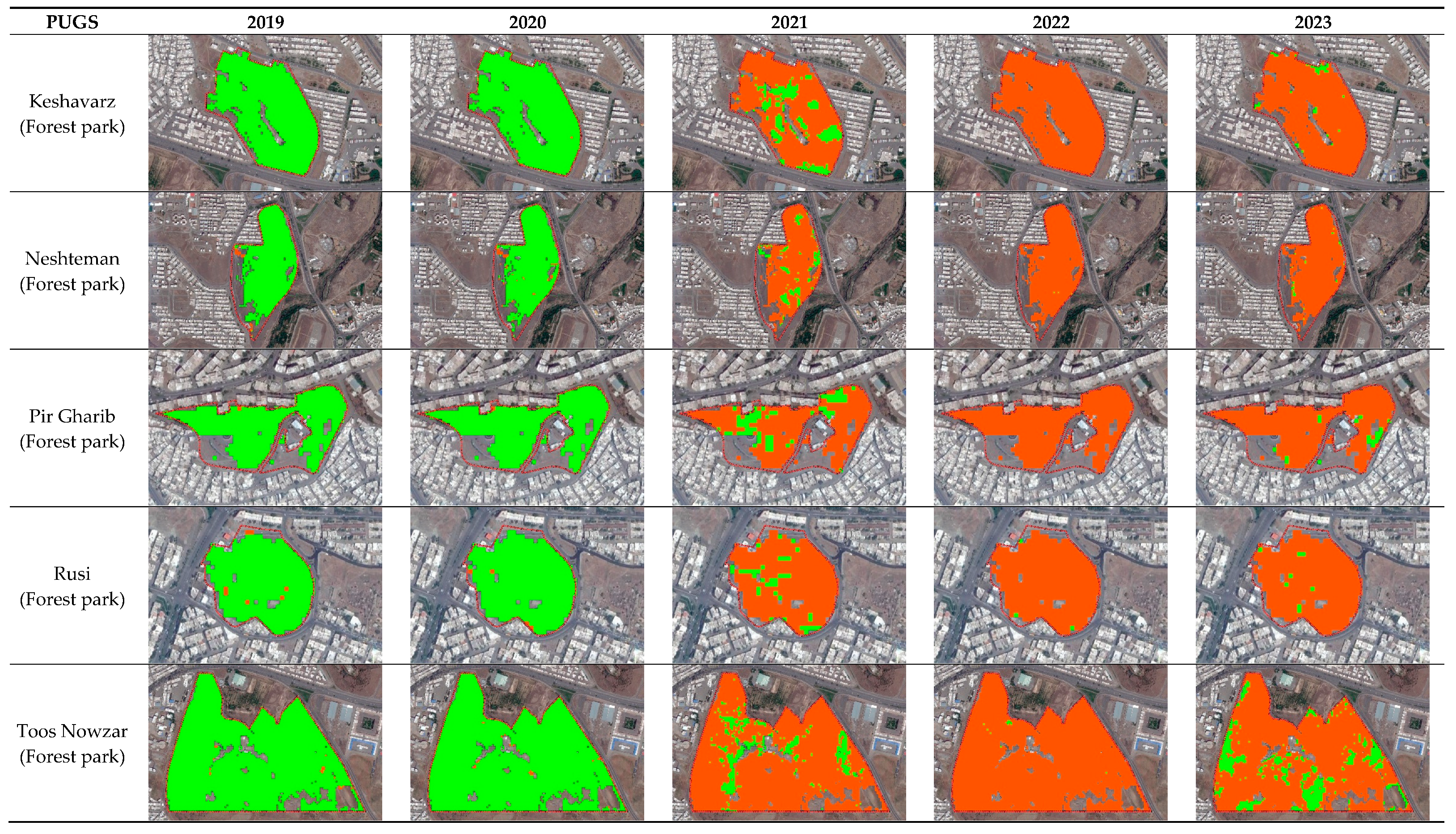
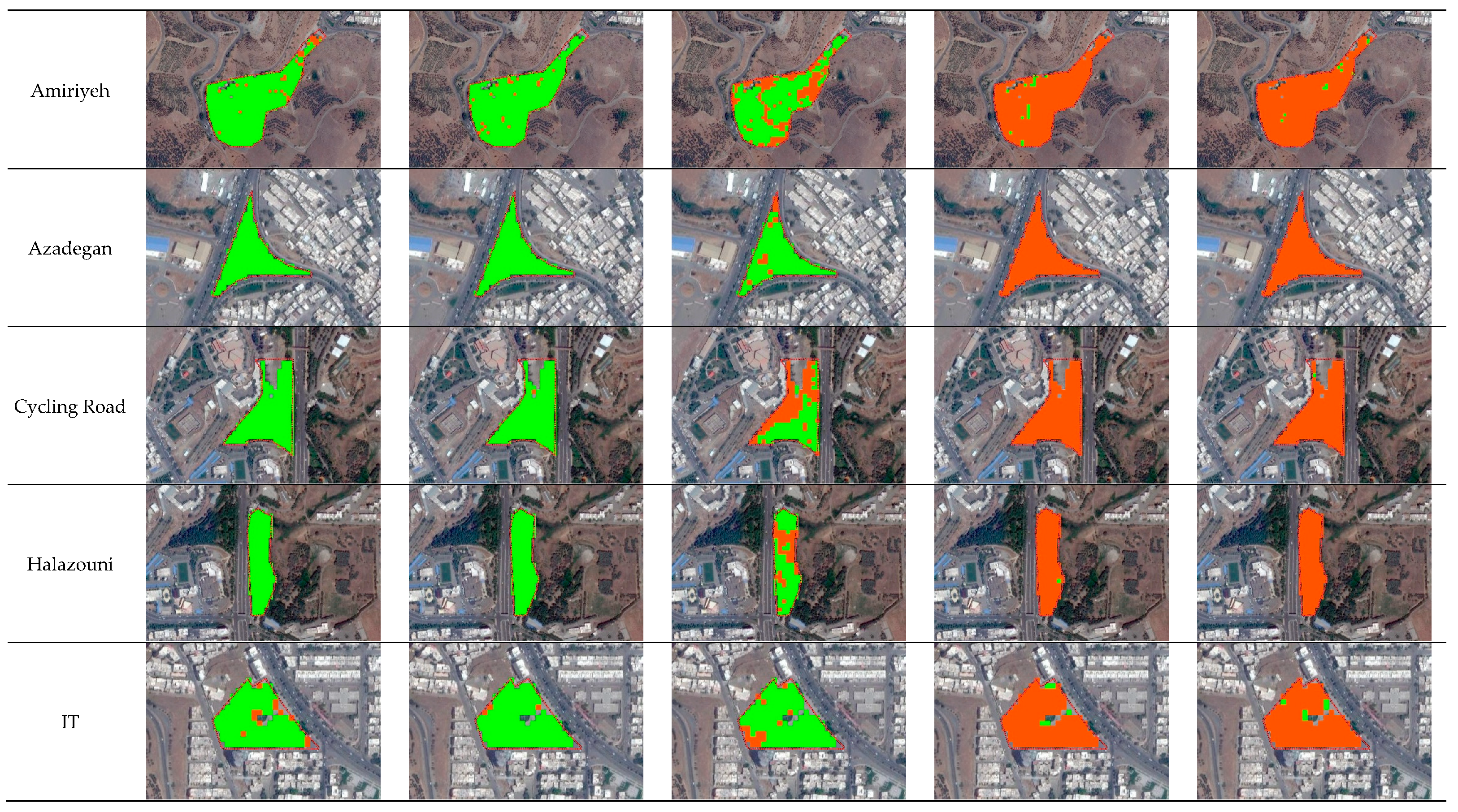
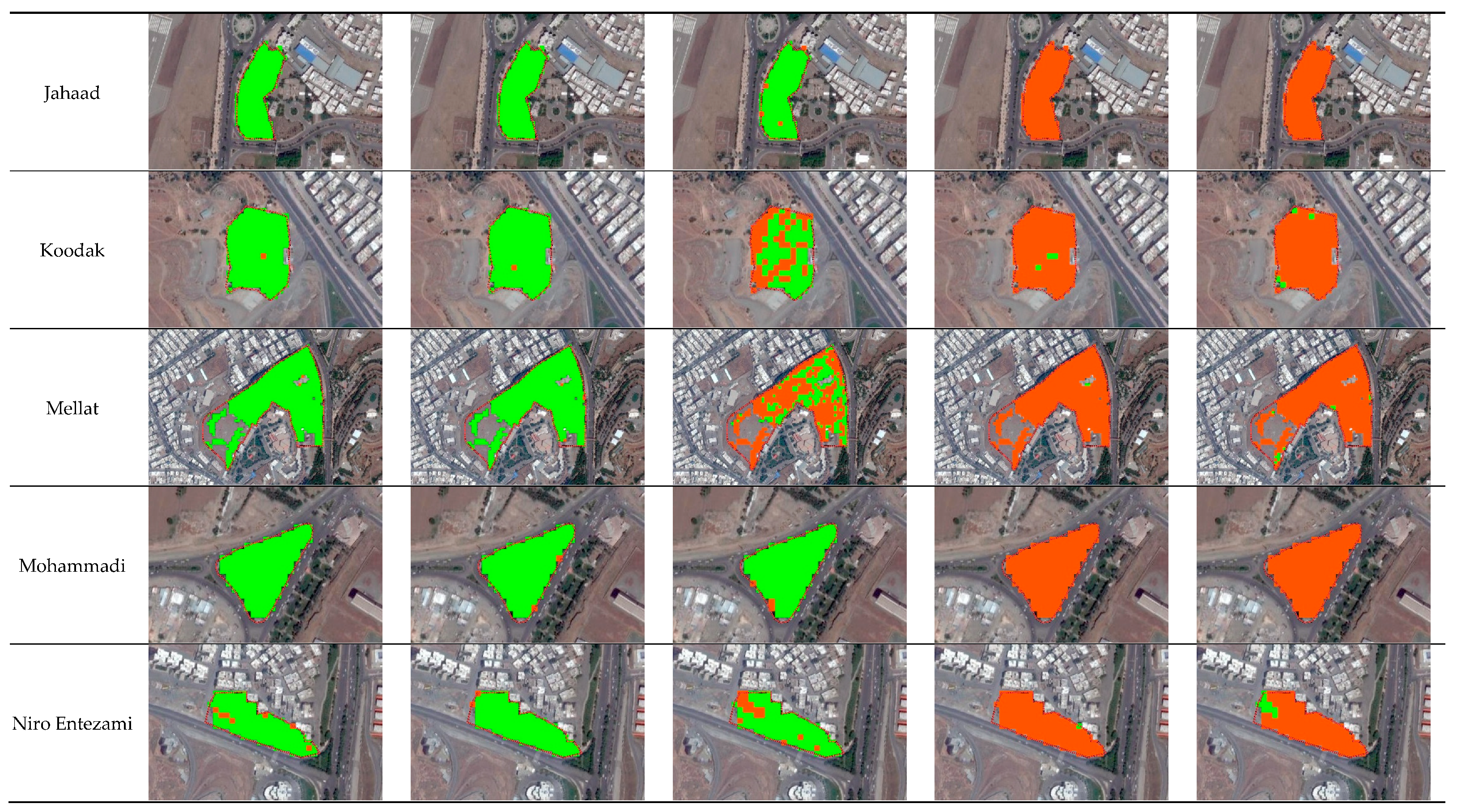
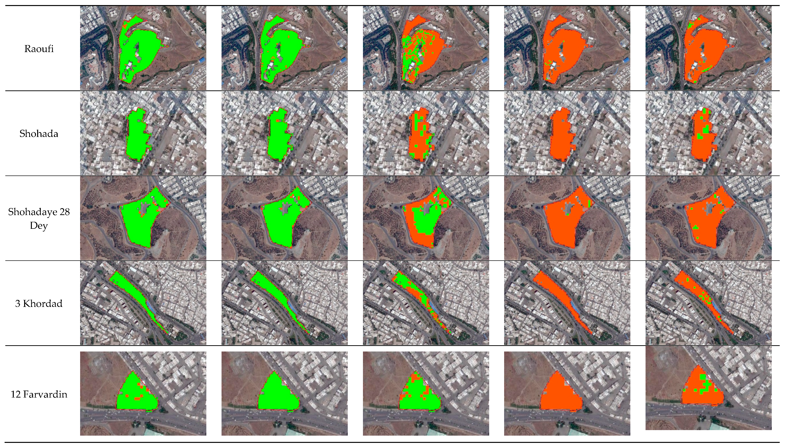
Change detection is of vital importance in assessing urban greenery. Table 5 shows the anomaly map of NDVI for all PUGSs over the study period. Based on the anomaly maps, the greenery of Sanandaj has declined sharply from 2021 onwards. This decline is particularly evident in forest parks, which can no longer be defined as PUGSs because, in this condition (pixels < 0 in anomaly maps), a PUGS has no cooling effect on the surrounding areas. In comparison to forest parks, other PUGSs have somewhat better conditions. Therefore, to improve urban greenery in Sanandaj, developing a novel plan to conserve forest parks should take priority over other parks.
4. Discussion
This study assessed urban greenery in Sanandaj, revealing a significant decline in the greenness of both trees and grass over the study period. In Sanandaj, there was no study which analyzed greenness of PUGSs using Sentinel-2 images.
To assess greenery in a city, it is vitally important to evaluate each UGS separately. To the best of author’s knowledge, this research is the first work in which the most important UGSs in a city were analyzed one by one. Previous studies have evaluated all UGSs in an entire city or a region [22,59,60] as a whole.
Classifying UGSs into different categories in terms of kind of irrigation and major landscapes is another important step in monitoring greenness in a city. Our results show that the NDVI value in PUGS (MG) is higher than the other type (MT). This is in line with the findings of Vulova et al. [61]. To the knowledge of the authors, there was no study on classifying UGSs according to type of irrigation (SIS vs FIS) to evaluate their greenery and make a detailed comparison between them.
Moreover, analyzing urban greenery temporally (monthly, seasonally and yearly) can be an effective tool for policy makers to get accurate information regarding the performance of UGSs during a specific study period. Overall, we found that Sanandaj has a dynamic green area. This is consistent with the study on Beijing, China [62]. Our findings show that spring and May is the greenest season and month in Sanandaj, respectively. In contrast, in summer time, the city has the lowest percentage of greenery.
The findings highlight the urgent need for effective strategies to improve the greenery in Sanandaj's PUGSs. Addressing this issue requires identifying the underlying causes of urban greenery loss in the city. The primary reason for the decline in greenery is poor management. Over recent years, the number of horticulturists has decreased significantly, despite their critical role in the conservation of PUGSs. For example, in four PUGSs, including Neshteman, Shohadaye 28 Dey, Amiriyeh, and Koodak, the number of horticulturists has decreased from 41 to just 14 during the study period. This reduction reflects a broader trend of declining attention to urban green space management, which is a significant contributor to the loss of greenery. Moreover, the change in urban park usage is a peculiar phenomenon in some PUGSs, especially in Toos Nowzar and Shohada parks, where people from all walks of life have become reluctant to visit. This shift not only limits access to green spaces but also has a negative impact on public safety within these parks. Therefore, revitalizing the social function of parks is essential for their sustainability. Another key issue is related to the species composition in urban parks. In cities like Sanandaj, which have a semi-arid climate, one of the critical factors in selecting species for urban parks is water demand. However, as shown in Table 6, in all 20 PUGSs, except Rusi and Shohada, there is at least one species with high water requirements, meaning that only 10 percent of PUGSs are optimally suited in terms of water efficiency. Therefore, the application of the landscape design concept "right plant, right place" as the novel green challenge in urban planning [63] is crucial. Silver berry, Nettle tree, and Sumac, native species of Sanandaj, are not represented in the main species of PUGSs, further exacerbating water demand issues.
Overall, when comparing natural climate variability with human-induced climate change, it is clear that the latter plays a significant role in the decline of urban greenery in Sanandaj. Human activities, particularly in urban planning and resource management, have accelerated the loss of urban greenery, compounding the impacts of climate change. This is in line with the findings of Dutta et al. [19].
In the context of PUGS boundaries, evaluating the greenness of these areas is a crucial factor in determining their cooling effect. In Sanandaj, relying on the proposed boundaries from the city’s detailed plan for PUGSs across all years can lead to erroneous assessments of greenery. Thus, it is essential to define specific thresholds for PUGSs based on their annual greenery levels. Without this, we risk incorrectly classifying some areas as UGSs. This issue is especially relevant for forest parks, where the boundary defined by the SDUP may not reflect the actual area covered by greenery. For instance, in Toos Nowzar forest park, the proposed boundary shows an area of 58.66 ha in 2022, while using NDVI calculations, the area in the same year is reduced markedly to 12.69 ha (see Figure 10). Thus, NDVI can serve as a useful tool for improving the determination of the real boundary of PUGSs, ensuring more accurate assessments of their ecological value.
5. Limitations and Future Directions
While this study provides a valuable framework for urban greenery assessment, it is limited by its relatively short temporal scope and reliance on specific RS datasets. Future research should extend the analysis over several decades by incorporating data from Landsat satellites to better understand long-term trends and the impact of drought on urban vegetation. Additionally, expanding the study to include other environmental variables, such as soil moisture and land surface temperature, could provide a more comprehensive understanding of PUGSs' role in urban climate regulation. Further research should also explore the direct cooling effects of PUGSs on their immediate surroundings, enhancing urban resilience and informing strategies for sustainable urban development.
In summary, this study highlights both the current challenges and potential strategies for enhancing urban greenery in Sanandaj. By implementing the recommended measures, the Sanandaj municipality can significantly improve its urban ecosystem, making it more resilient to climate change and better equipped to meet the needs of its residents.
6. Conclusions
This study underscores the value of RS techniques in urban greenery analysis, providing essential data for climate change studies and UHI mitigation. By focusing on Sanandaj's PUGSs, we assessed changes in greenery levels over the past five years, offering new insights into the city's urban vegetation health and management. This approach fills a significant research gap, as it is the first to evaluate Sanandaj's urban greenery using RS techniques in such a detailed temporal scale.
Our findings reveal a critical need to redefine PUGSs based on Vegetation Indices (VI), especially the NDVI, which offers a scientifically robust approach to delineating and categorizing green spaces. This study emphasizes that defining the borders of PUGSs through NDVI and other VIs provides more accurate insights into their cooling capacity and visual appeal, crucial for urban planning and public health. The analysis of NDVI patterns in 20 prominent parks, performed across annual, seasonal, and monthly scales, reveals a consistent decline in greenery. This reduction is particularly alarming in larger forest parks, signaling an urgent need for action to reverse the trend.
It is crystal clear that PUGSs play a crucial role in mitigating the UHI effect. Therefore, it is imperative to implement effective strategies to enhance their cooling potential in Sanandaj. Based on the findings of this study, several key recommendations should be adopted by the Sanandaj municipality to improve the management and effectiveness of PUGSs. These include: (i) adopting vegetation-based borders (VB) for PUGSs through VI analysis; (ii) increasing horticultural staff, especially during the summer months when vegetation is most vulnerable; (iii) applying the "right plant, right place" principle to ensure that species with suitable water demands are selected for each park, thereby reducing unnecessary water consumption; (iv) considering NDVI as a key factor in determining UGS per capita within the SDUP to facilitate more accurate and sustainable urban greenery planning; and (v) revitalizing underutilized parks, such as Toos Nowzar and Shohada, to attract a broader range of visitors and transform them into safe and vibrant community hubs. By implementing these recommendations, Sanandaj can improve its urban greenery, enhance its resilience to climate change, and foster healthier, more sustainable urban environments for its residents.
Author Contributions
Conceptualization, W.L., H.N., and N.A.; Methodology, W.L., H.N., and N.A.; Software, W.L., N.A.; Validation, W.L., H.N., N.A., L.K., and A.C.; Formal Analysis, W.L., H.N., and N.A.; Investigation, W.L., H.N., and N.A.; Resources, W.L., H.N., and N.A.; Data Curation, W.L., N.A.; Writing – Original Draft Preparation, W.L.; Writing – Review & Editing, W.L., H.N., N.A., L.K, and A.C; Visualization, W.L. Supervision, H.N., and N.A.; Project Administration, W.L., H.N., and N.A.; Funding Acquisition, W.L., H.N., N.A., and A.C. All authors have read and agreed to the published version of the manuscript.
Data Availability Statement & Software Citation
The data used in this study were obtained from Sentinel-2 satellite imagery, which is publicly available through the European Space Agency (ESA). Data processing and analysis were conducted using Google Earth Engine (GEE) for satellite data access and analysis, and Quantum Geographic Information System (QGIS) for spatial data visualization and mapping. Both platforms are open-source, ensuring reproducibility and accessibility for further research.
Acknowledgments
The author(s) would like to thank the ESA for providing access to Sentinel-2 imagery, as well as the teams behind GEE and QGIS for their powerful and accessible tools that greatly facilitated data processing and analysis. Special thanks also go to Sanandaj municipality and the IRIMO for their cooperation and provision of relevant data on public green spaces and climate, which were essential for the completion of this study.
Conflicts of Interest
The author(s) declare no conflicts of interest related to this article. Furthermore, no research funding was received for conducting this study.
References
- UN (2018) World population prospects: The 2018 revision, New York, USA: Population Division, Department of Economic and Social Affairs, United Nations.
- Sun, Y.; Augenbroe, G. Urban heat island effect on energy application studies of office buildings. Energy and Buildings 2014, 77, 171–179. [Google Scholar] [CrossRef]
- Vaisi, S.; Alizadeh, H.; Lotfi, W.; Mohammadi, S. Developing the ecological footprint assessment for a university campus, the component-based method. Sustainability 2021, 13, 9928. [Google Scholar] [CrossRef]
- Jiang, W.; Huang, Y.; Sha, A. A review of eco-friendly functional road materials. Construction and Building Materials 2018, 191, 1082–1092. [Google Scholar] [CrossRef]
- Liu, X.; Sun, T.; Feng, Q. Dynamic spatial spillover effect of urbanization on environmental pollution in China considering the inertia characteristics of environmental pollution. Sustainable Cities and Society 2020, 53, 101903. [Google Scholar] [CrossRef]
- Miller, J. D.; Hutchins, M. The impacts of urbanisation and climate change on urban flooding and urban water quality: A review of the evidence concerning the United Kingdom. Journal of Hydrology: Regional Studies 2017, 12, 345–362. [Google Scholar] [CrossRef]
- Liang, L.; Wang, Z.; Li, J. The effect of urbanization on environmental pollution in rapidly developing urban agglomerations. Journal of cleaner production 2019, 237, 117649. [Google Scholar] [CrossRef]
- Woldesemayat, E. M.; Genovese, P. V. Monitoring urban expansion and urban green spaces change in Addis Ababa: directional and zonal analysis integrated with landscape expansion index. Forests 2021, 12, 389. [Google Scholar] [CrossRef]
- Bai, T.; Mayer, A. L.; Shuster, W. D.; Tian, G. The hydrologic role of urban green space in mitigating flooding (Luohe, China). Sustainability 2018, 10, 3584. [Google Scholar] [CrossRef]
- Wan, H.; McLaughlin, D.; Shao, Y.; van Eerden, B.; Ranganathan, S.; Deng, X. Remotely-sensed evapotranspiration for informed urban forest management. Landscape and Urban Planning 2021, 210, 104069. [Google Scholar] [CrossRef]
- Liu, W.; Chen, W.; Peng, C. Assessing the effectiveness of green infrastructures on urban flooding reduction: A community scale study. Ecological Modelling 2014, 291, 6–14. [Google Scholar] [CrossRef]
- Ramaiah, M.; Avtar, R. Urban green spaces and their need in cities of rapidly urbanizing India: A review. Urban science 2019, 3, 94. [Google Scholar] [CrossRef]
- Kim, H. W.; Kim, J.-H.; Li, W.; Yang, P.; Cao, Y. Exploring the impact of green space health on runoff reduction using NDVI. Urban Forestry & Urban Greening 2017, 28, 81–87. [Google Scholar]
- Li, W.; Saphores, J.-D. M.; Gillespie, T. W. A comparison of the economic benefits of urban green spaces estimated with NDVI and with high-resolution land cover data. Landscape and Urban Planning 2015, 133, 105–117. [Google Scholar] [CrossRef]
- Xie, Y.; Xiang, H.; Di, N.; Mao, Z.; Hou, J.; Liu, X.; Huo, W.; Yang, B.; Dong, G.; Wang, C. Association between residential greenness and sleep quality in Chinese rural population. Environment International 2020, 145, 106100. [Google Scholar] [CrossRef]
- Kweon, B.-S.; Ellis, C. D.; Lee, J.; Jacobs, K. The link between school environments and student academic performance. Urban forestry & urban greening 2017, 23, 35–43. [Google Scholar]
- Matsuoka, R. H. Student performance and high school landscapes: Examining the links. Landscape and urban planning 2010, 97, 273–282. [Google Scholar] [CrossRef]
- Nouri, H.; Borujeni, S. C.; Hoekstra, A. Y. The blue water footprint of urban green spaces: An example for Adelaide, Australia. Landscape and urban planning 2019, 190, 103613. [Google Scholar] [CrossRef]
- Dutta, D.; Rahman, A.; Paul, S.; Kundu, A. Spatial and temporal trends of urban green spaces: an assessment using hyper-temporal NDVI datasets. Geocarto International 2022, 37, 7983–8003. [Google Scholar] [CrossRef]
- Anguluri, R.; Narayanan, P. Role of green space in urban planning: Outlook towards smart cities. Urban Forestry & Urban Greening 2017, 25, 58–65. [Google Scholar]
- Aryal, J.; Sitaula, C.; Aryal, S. NDVI threshold-based urban green space mapping from sentinel-2A at the Local Governmental Area (LGA) level of victoria, Australia. Land 2022, 11, 351. [Google Scholar] [CrossRef]
- Chen, Q.; Zhong, C.; Jing, C.; Li, Y.; Cao, B.; Cheng, Q. Rapid mapping and annual dynamic evaluation of quality of urban green spaces on google earth engine. ISPRS International Journal of Geo-Information 2021, 10, 670. [Google Scholar] [CrossRef]
- Bai, H.; Li, Z.; Guo, H.; Chen, H.; Luo, P. Urban green space planning based on remote sensing and geographic information systems. Remote Sensing 2022, 14, 4213. [Google Scholar] [CrossRef]
- Norton, B. A.; Coutts, A. M.; Livesley, S. J.; Harris, R. J.; Hunter, A. M.; Williams, N. S. Planning for cooler cities: A framework to prioritise green infrastructure to mitigate high temperatures in urban landscapes. Landscape and urban planning 2015, 134, 127–138. [Google Scholar] [CrossRef]
- Sun, Y.; Xie, S.; Zhao, S. Valuing urban green spaces in mitigating climate change: A city-wide estimate of aboveground carbon stored in urban green spaces of China's Capital. Global change biology 2019, 25, 1717–1732. [Google Scholar] [CrossRef] [PubMed]
- Nouri, H.; Beecham, S.; Kazemi, F.; Hassanli, A. M. A review of ET measurement techniques for estimating the water requirements of urban landscape vegetation. Urban Water Journal 2013, 10, 247–259. [Google Scholar] [CrossRef]
- Deng, J.; Huang, Y.; Chen, B.; Tong, C.; Liu, P.; Wang, H.; Hong, Y. A methodology to monitor urban expansion and green space change using a time series of multi-sensor SPOT and Sentinel-2A images. Remote Sensing 2019, 11, 1230. [Google Scholar] [CrossRef]
- Kowe, P.; Mutanga, O.; Dube, T. Advancements in the remote sensing of landscape pattern of urban green spaces and vegetation fragmentation. International Journal of Remote Sensing 2021, 42, 3797–3832. [Google Scholar] [CrossRef]
- Neyns, R.; Canters, F. Mapping of urban vegetation with high-resolution remote sensing: A review. Remote sensing 2022, 14, 1031. [Google Scholar] [CrossRef]
- Alonzo, M.; Bookhagen, B.; Roberts, D. A. Urban tree species mapping using hyperspectral and lidar data fusion. Remote sensing of environment 2014, 148, 70–83. [Google Scholar] [CrossRef]
- Pettorelli, N. The normalized difference vegetation index; Oxford University Press 2013, USA,.
- Duro, D. C.; Coops, N. C.; Wulder, M. A.; Han, T. Development of a large area biodiversity monitoring system driven by remote sensing. Progress in physical geography 2007, 31, 235–260. [Google Scholar] [CrossRef]
- Hamdy, O. Using remote sensing techniques to assess the changes in the rate of urban green spaces in Egypt: a case study of greater Cairo. International Design Journal 2022, 12, 53–64. [Google Scholar] [CrossRef]
- Fung, T.; Siu, W. Environmental quality and its changes, an analysis using NDVI. International Journal of Remote Sensing 2000, 21, 1011–1024. [Google Scholar] [CrossRef]
- Pettorelli, N.; Vik, J. O.; Mysterud, A.; Gaillard, J.-M.; Tucker, C. J.; Stenseth, N. C. Using the satellite-derived NDVI to assess ecological responses to environmental change. Trends in ecology & evolution 2005, 20, 503–510. [Google Scholar]
- Alcaraz-Segura, D.; Cabello, J.; Paruelo, J. M.; Delibes, M. Use of descriptors of ecosystem functioning for monitoring a national park network: a remote sensing approach. Environmental Management 2009, 43, 38–48. [Google Scholar] [CrossRef]
- Wu, C.; Peng, D.; Soudani, K.; Siebicke, L.; Gough, C. M.; Arain, M. A.; Bohrer, G.; Lafleur, P. M.; Peichl, M.; Gonsamo, A. Land surface phenology derived from normalized difference vegetation index (NDVI) at global FLUXNET sites. Agricultural and Forest Meteorology 2017, 233, 171–182. [Google Scholar] [CrossRef]
- Zamani-Noor, N.; Feistkorn, D. Monitoring growth status of winter oilseed rape by NDVI and NDYI derived from UAV-based Red–Green–Blue imagery. Agronomy 2022, 12, 2212. [Google Scholar] [CrossRef]
- Abbasi, N.; Nouri, H.; Didan, K.; Barreto-Muñoz, A.; Chavoshi Borujeni, S.; Salemi, H.; Opp, C.; Siebert, S.; Nagler, P. Estimating actual evapotranspiration over croplands using vegetation index methods and dynamic harvested area. Remote Sensing 2021, 13, 5167. [Google Scholar] [CrossRef]
- Hüttich*, C.; Herold, M.; Schmullius, C.; Egorov, V.; Bartalev, S. Indicators of Northern Eurasia's land-cover change trends from SPOT-VEGETATION time-series analysis 1998–2005. International Journal of Remote Sensing 2007, 28, 4199–4206. [Google Scholar] [CrossRef]
- Tomasella, J.; Vieira, R. M. S. P.; Barbosa, A. A.; Rodriguez, D. A.; de Oliveira Santana, M.; Sestini, M. F. Desertification trends in the Northeast of Brazil over the period 2000–2016. International Journal of Applied Earth Observation and Geoinformation 2018, 73, 197–206. [Google Scholar] [CrossRef]
- Aburas, M. M.; Abdullah, S. H.; Ramli, M. F.; Ash’aari, Z. H. Measuring land cover change in Seremban, Malaysia using NDVI index. Procedia Environmental Sciences 2015, 30, 238–243. [Google Scholar] [CrossRef]
- Mutti, P. R.; Lúcio, P. S.; Dubreuil, V.; Bezerra, B. G. NDVI time series stochastic models for the forecast of vegetation dynamics over desertification hotspots. International Journal of Remote Sensing 2020, 41, 2759–2788. [Google Scholar] [CrossRef]
- Nyamekye, C.; Schönbrodt-Stitt, S.; Amekudzi, L. K.; Zoungrana, B. J. B.; Thiel, M. Usage of MODIS NDVI to evaluate the effect of soil and water conservation measures on vegetation in Burkina Faso. Land Degradation & Development 2021, 32, 7–19. [Google Scholar]
- Huang, S.; Tang, L.; Hupy, J. P.; Wang, Y.; Shao, G. A commentary review on the use of normalized difference vegetation index (NDVI) in the era of popular remote sensing. Journal of Forestry Research 2021, 32, 1–6. [Google Scholar] [CrossRef]
- Liu, Y.; Li, Y.; Li, S.; Motesharrei, S. Spatial and temporal patterns of global NDVI trends: correlations with climate and human factors. Remote Sensing 2015, 7, 13233–13250. [Google Scholar] [CrossRef]
- Baker, F.; Smith, C. L.; Cavan, G. A combined approach to classifying land surface cover of urban domestic gardens using citizen science data and high resolution image analysis. Remote Sensing 2018, 10, 537. [Google Scholar] [CrossRef]
- Hartling, S.; Sagan, V.; Sidike, P.; Maimaitijiang, M.; Carron, J. Urban tree species classification using a WorldView-2/3 and LiDAR data fusion approach and deep learning. Sensors 2019, 19, 1284. [Google Scholar] [CrossRef]
- Huang, C.; Yang, J.; Jiang, P. Assessing impacts of urban form on landscape structure of urban green spaces in China using Landsat images based on Google Earth Engine. Remote Sensing 2018, 10, 1569. [Google Scholar] [CrossRef]
- Rafiee, R.; Mahiny, A. S.; Khorasani, N. Assessment of changes in urban green spaces of Mashad city using satellite data. International Journal of Applied Earth Observation and Geoinformation 2009, 11, 431–438. [Google Scholar] [CrossRef]
- Chun, B.; Guldmann, J.-M. Impact of greening on the urban heat island: Seasonal variations and mitigation strategies. Computers, Environment and Urban Systems 2018, 71, 165–176. [Google Scholar] [CrossRef]
- Abbasi, F.; Bazgeer, S.; Kalehbasti, P. R.; Oskoue, E. A.; Haghighat, M.; Kalehbasti, P. R. New climatic zones in Iran: a comparative study of different empirical methods and clustering technique. Theoretical and Applied Climatology 2022, 1–15. [Google Scholar]
- General Census of Population and Housing, Statistical Center of Iran 2020, Iran.
- Velastegui-Montoya, A.; Montalván-Burbano, N.; Carrión-Mero, P.; Rivera-Torres, H.; Sadeck, L.; Adami, M. Google Earth Engine: a global analysis and future trends. Remote Sensing 2023, 15, 3675. [Google Scholar] [CrossRef]
- Li, X.; Hai, Q.; Zhu, Z.; Zhang, D.; Shao, Y.; Zhao, Y.; Li, H.; Vandansambuu, B.; Ning, X.; Chen, D. Spatial and temporal changes in vegetation cover in the three north protection forest project area supported by GEE cloud platform. Forests 2023, 14, 295. [Google Scholar] [CrossRef]
- GEE Google Earth Engine. 2023. Available online: https://earthengine.google.com/ (accessed on 3 May 2023).
- ESA, Application of Sentinel-2. Available online: https://www.esa.int/Applications/Observing_the_Earth/Copernicus/Sentinel-2 (accessed on 24 December 2024).
- QGIS Quantum Geographic Information System. 2023. Available online: http://www.qgis.org (accessed on 8 October 2024).
- Furberg, D.; Ban, Y.; Mörtberg, U. Monitoring urban green infrastructure changes and impact on habitat connectivity using high-resolution satellite data. Remote Sensing 2020, 12, 3072. [Google Scholar] [CrossRef]
- Pouya, S.; Aghlmand, M. Evaluation of urban green space per capita with new remote sensing and geographic information system techniques and the importance of urban green space during the COVID-19 pandemic. Environmental monitoring and assessment 2022, 194, 633. [Google Scholar] [CrossRef]
- Vulova, S.; Rocha, A. D.; Meier, F.; Nouri, H.; Schulz, C.; Soulsby, C.; Tetzlaff, D.; Kleinschmit, B. City-wide, high-resolution mapping of evapotranspiration to guide climate-resilient planning. Remote Sensing of Environment 2023, 287, 113487. [Google Scholar] [CrossRef]
- Chen, A.; Yao, X. A.; Sun, R.; Chen, L. Effect of urban green patterns on surface urban cool islands and its seasonal variations. Urban forestry & urban greening 2014, 13, 646–654. [Google Scholar]
- Farinati, S.; Betto, A.; Palumbo, F.; Scariolo, F.; Vannozzi, A.; Barcaccia, G. The new green challenge in urban planning: The right genetics in the right place. Horticulturae 2022, 8, 761. [Google Scholar] [CrossRef]
Figure 1.
Map of the study area and climate data (temperature and precipitation) of Sanandaj from 1992 to 2023; (a) Map of Iran, Kurdistan province, and Sanandaj, with the red line indicating its boundary contains imagery © Google earth pro V 7.3.6.10155 (July 13, 2024). Sanandaj, Iran. 35°18'39.98"N, 46°59'48.66"E, Eye alt 57874 feet. Airbus 2024. https://earth.google.com/; (b) Annual precipitation in Sanandaj (1992–2023); (c) Maximum monthly mean temperature in Sanandaj (1992–2023); (d) Climograph of Sanandaj (1992–2023), with the orange pattern indicating the dry period of Sanandaj from 1992 to 2023.
Figure 1.
Map of the study area and climate data (temperature and precipitation) of Sanandaj from 1992 to 2023; (a) Map of Iran, Kurdistan province, and Sanandaj, with the red line indicating its boundary contains imagery © Google earth pro V 7.3.6.10155 (July 13, 2024). Sanandaj, Iran. 35°18'39.98"N, 46°59'48.66"E, Eye alt 57874 feet. Airbus 2024. https://earth.google.com/; (b) Annual precipitation in Sanandaj (1992–2023); (c) Maximum monthly mean temperature in Sanandaj (1992–2023); (d) Climograph of Sanandaj (1992–2023), with the orange pattern indicating the dry period of Sanandaj from 1992 to 2023.
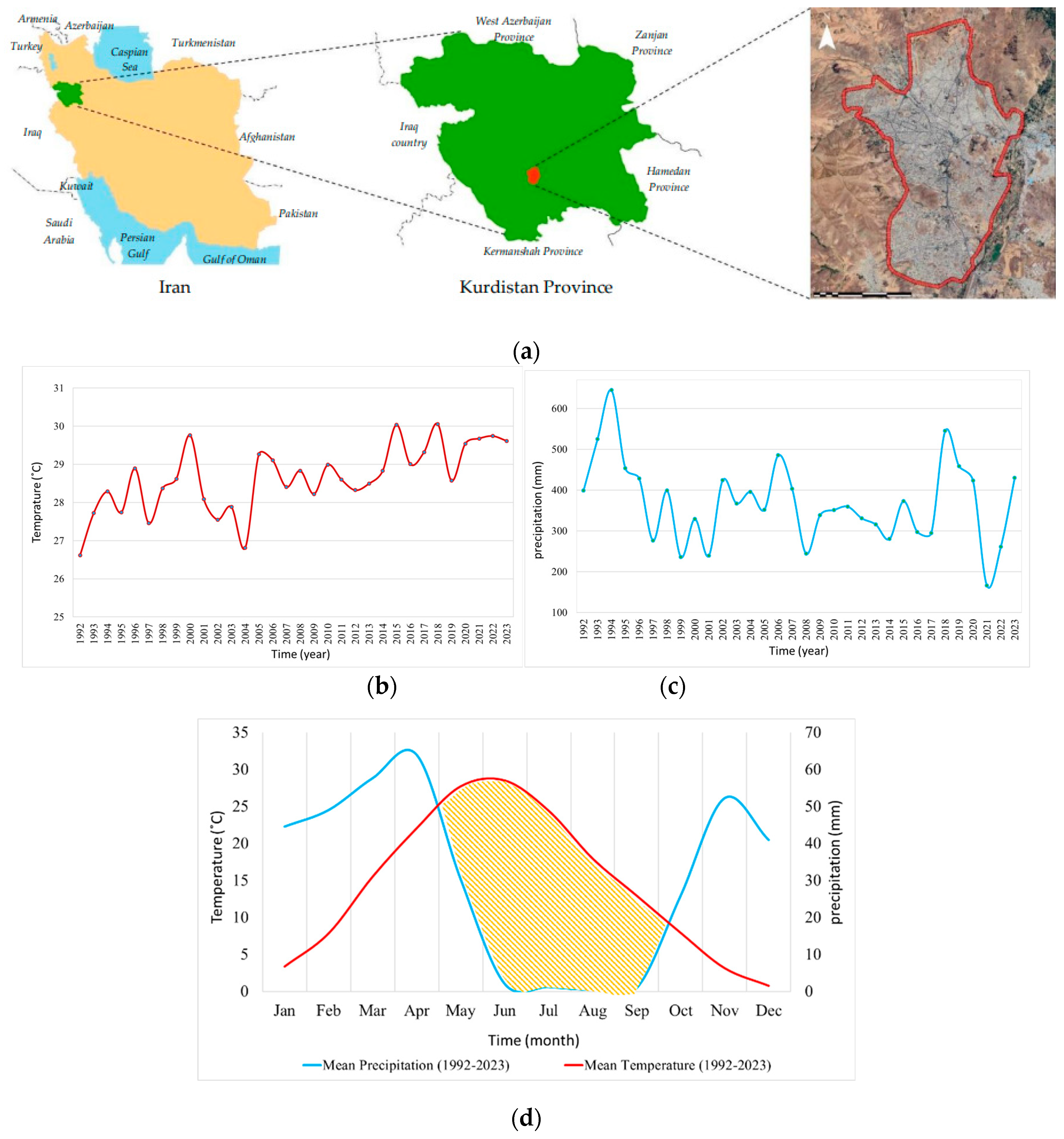
Figure 2.
Distribution of selected public urban green spaces (PUGS) in Sanandaj (contains imagery © Google earth pro V 7.3.6.10155 (July 13, 2024). Sanandaj, Iran. 35°18'39.98"N, 46°59'48.66"E, Eye alt 57874 feet. Airbus 2024. https://earth.google.com/).
Figure 2.
Distribution of selected public urban green spaces (PUGS) in Sanandaj (contains imagery © Google earth pro V 7.3.6.10155 (July 13, 2024). Sanandaj, Iran. 35°18'39.98"N, 46°59'48.66"E, Eye alt 57874 feet. Airbus 2024. https://earth.google.com/).
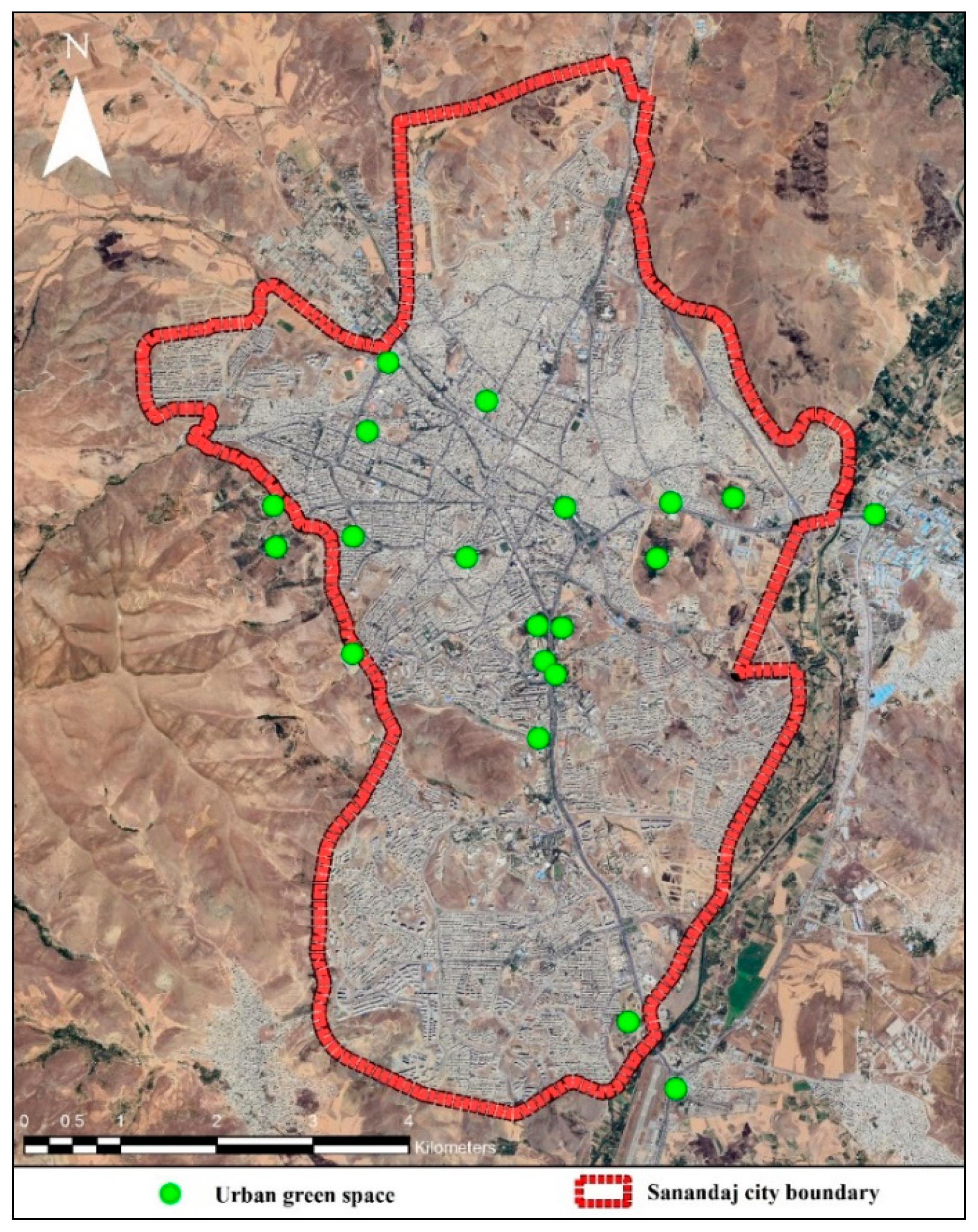
Figure 3.
Flowchart of the research process. PUGS: Public Urban Green Space; MG: Mostly covered with grass; MT: Mostly covered with trees.
Figure 3.
Flowchart of the research process. PUGS: Public Urban Green Space; MG: Mostly covered with grass; MT: Mostly covered with trees.
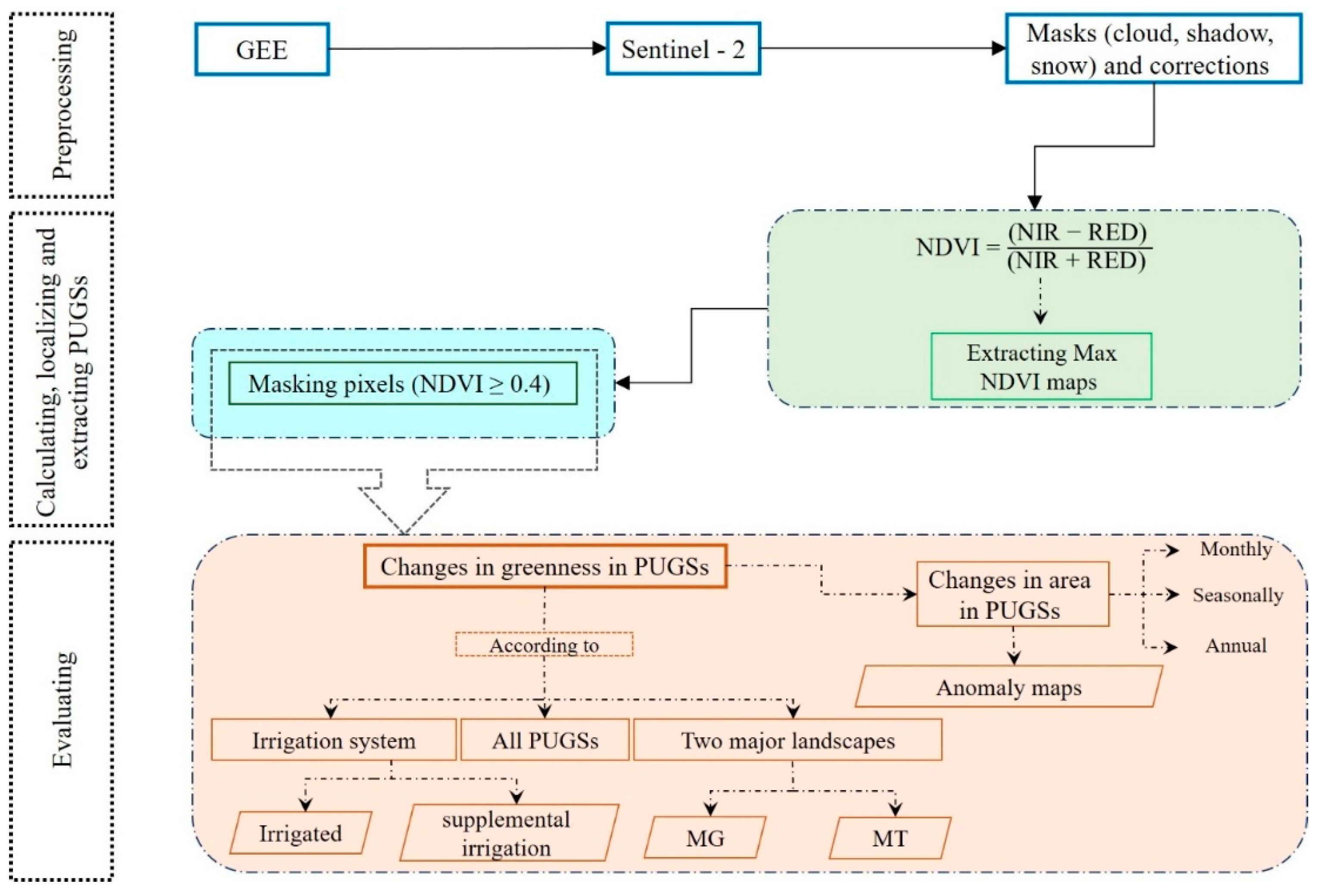
Figure 4.
Monthly mean NDVI of all PUGSs in Sanandaj city from 2019 to 2023.
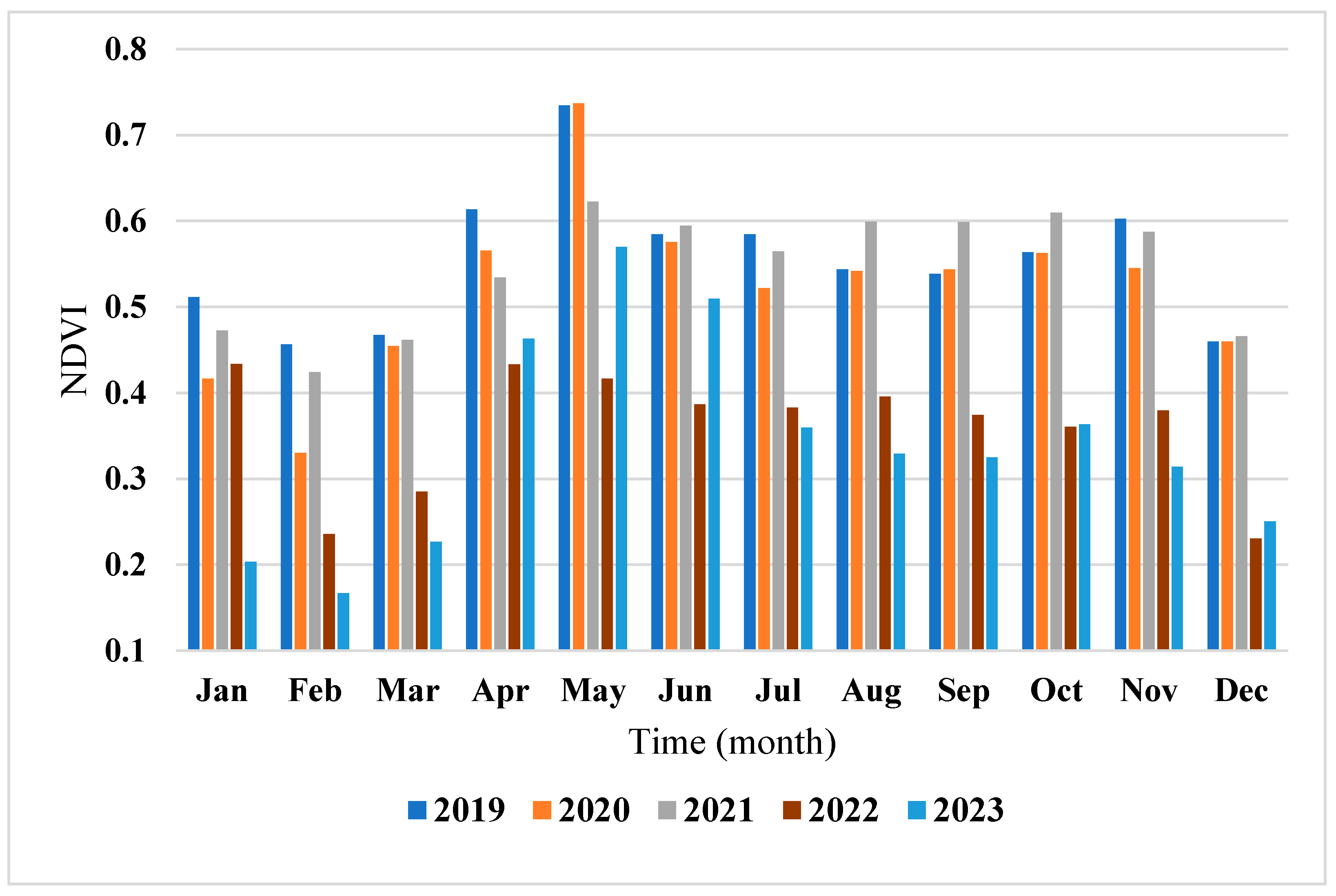
Figure 5.
Monthly mean NDVI of all PUGSs in Sanandaj (2019-2023) based on the type of irrigation system.
Figure 5.
Monthly mean NDVI of all PUGSs in Sanandaj (2019-2023) based on the type of irrigation system.
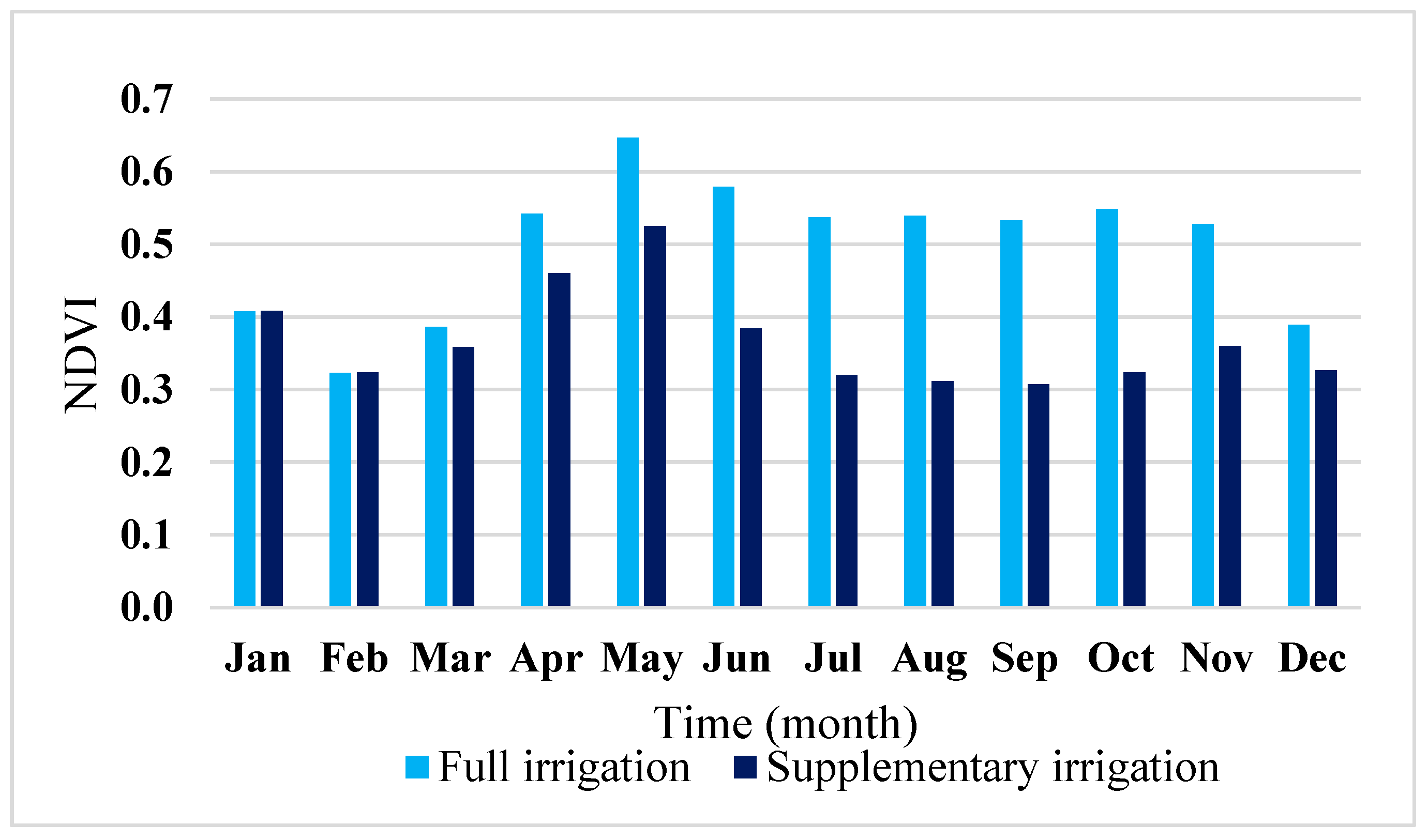
Figure 6.
Monthly mean NDVI of all PUGSs based on major landscape types in Sanandaj from 2019 to 2023.
Figure 6.
Monthly mean NDVI of all PUGSs based on major landscape types in Sanandaj from 2019 to 2023.
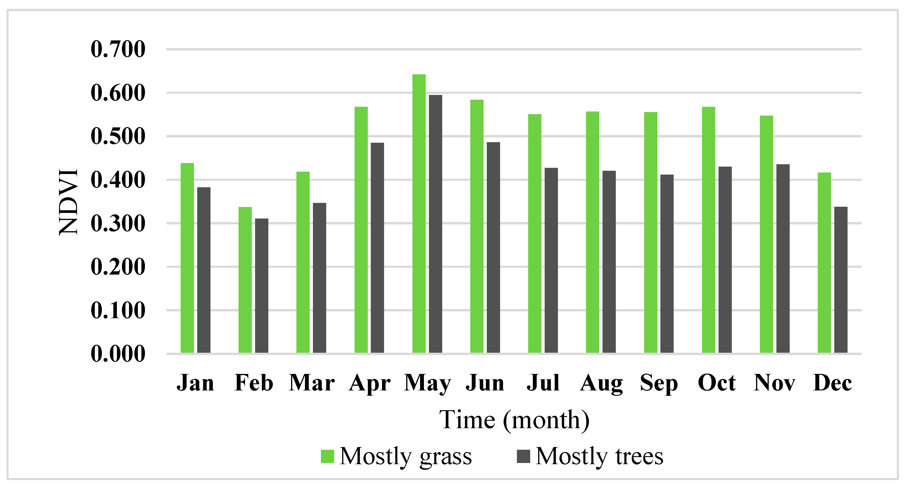
Figure 7.
Seasonal changes in the area of PUGSs in Sanandaj based on irrigation type from 2019 to 2023; (a) Full irrigation; (b) Supplementary irrigation.
Figure 7.
Seasonal changes in the area of PUGSs in Sanandaj based on irrigation type from 2019 to 2023; (a) Full irrigation; (b) Supplementary irrigation.
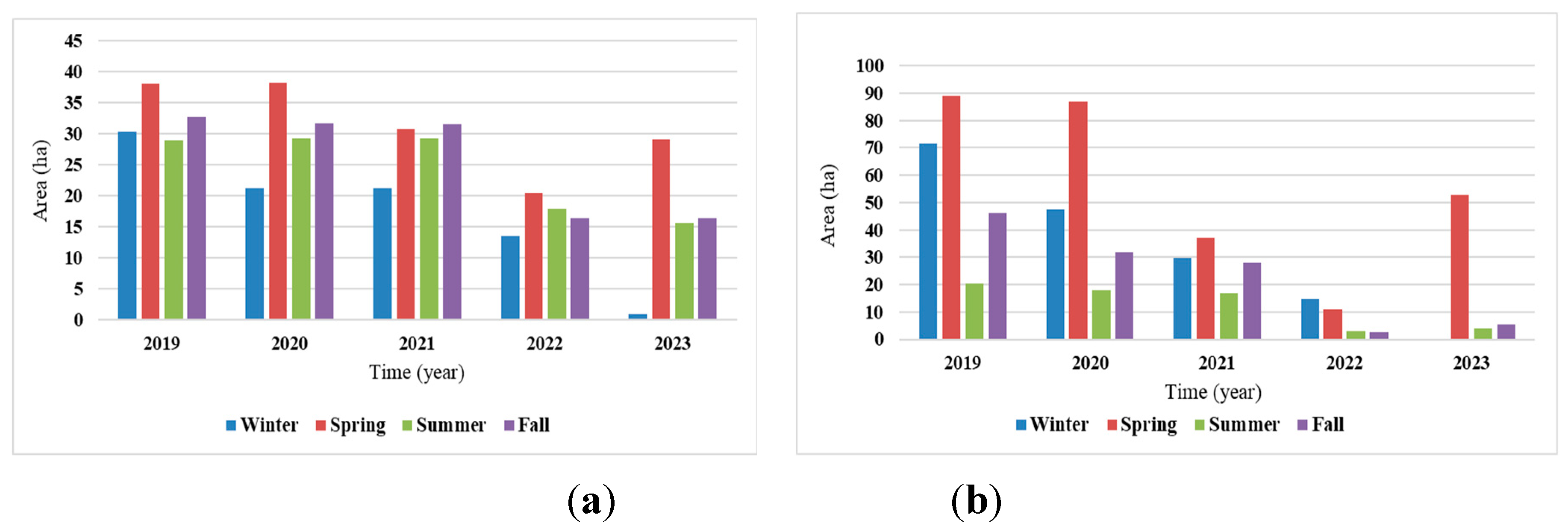
Figure 8.
Example of mapping changes in the area of a PUGS (Neshteman Forest Park) from 2019 to 2023 (during the greenest month of the year) using NDVI. The red border represents the boundary of the PUGS according to the SDUP. contains imagery © Google earth pro V 7.3.6.10155 (July 13, 2024). Sanandaj, Iran. 35°15'42.98"N, 47° 0'38.10"E, Eye alt 9317 feet. Airbus 2024. https://earth.google.com/.
Figure 8.
Example of mapping changes in the area of a PUGS (Neshteman Forest Park) from 2019 to 2023 (during the greenest month of the year) using NDVI. The red border represents the boundary of the PUGS according to the SDUP. contains imagery © Google earth pro V 7.3.6.10155 (July 13, 2024). Sanandaj, Iran. 35°15'42.98"N, 47° 0'38.10"E, Eye alt 9317 feet. Airbus 2024. https://earth.google.com/.
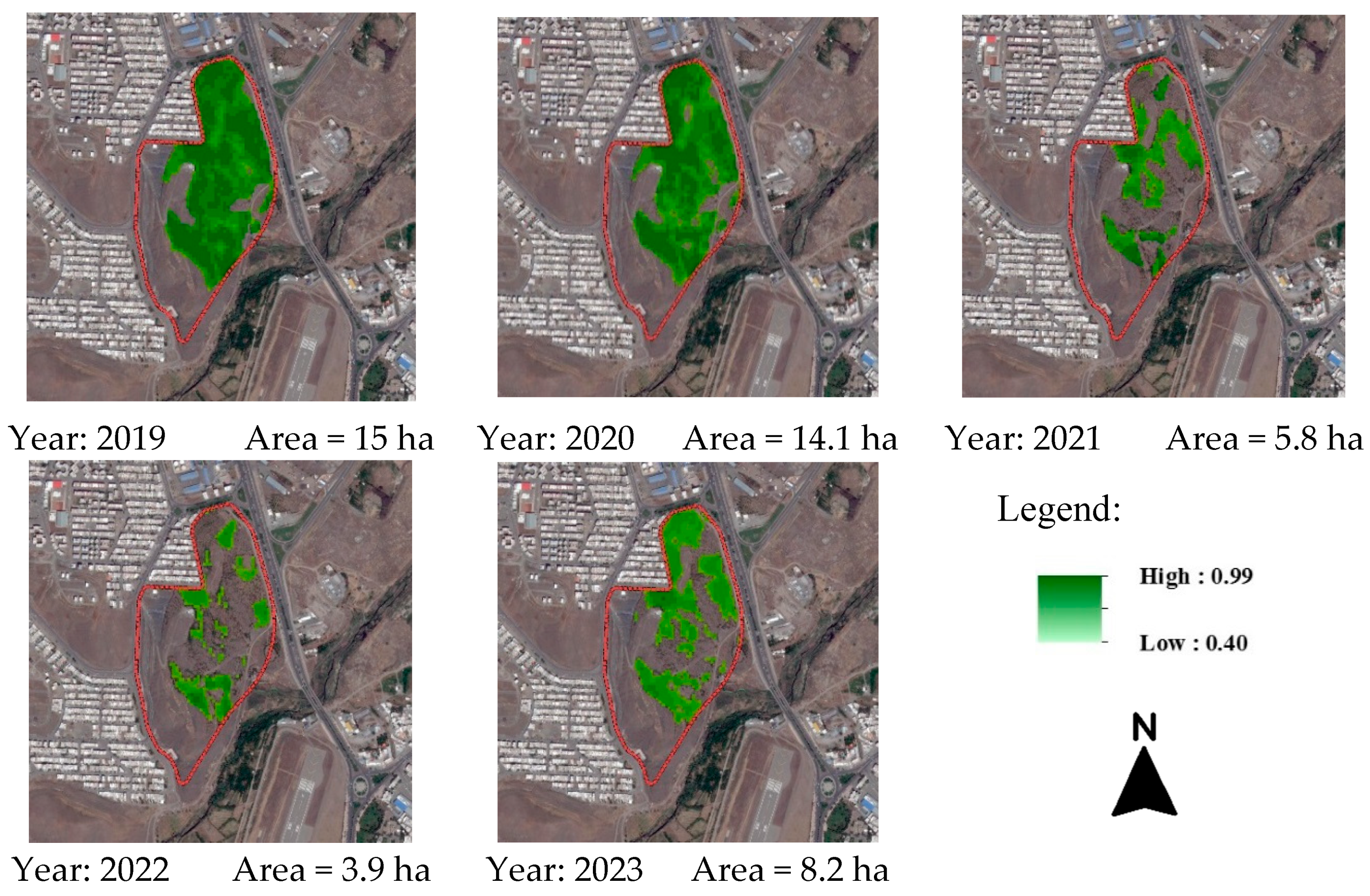
Figure 9.
Seasonal changes in the area of PUGSs in Sanandaj based on major landscape from 2019 to 2023; (a) PUGSs predominantly covered with grass and turf; (b) PUGSs predominantly covered with trees.
Figure 9.
Seasonal changes in the area of PUGSs in Sanandaj based on major landscape from 2019 to 2023; (a) PUGSs predominantly covered with grass and turf; (b) PUGSs predominantly covered with trees.
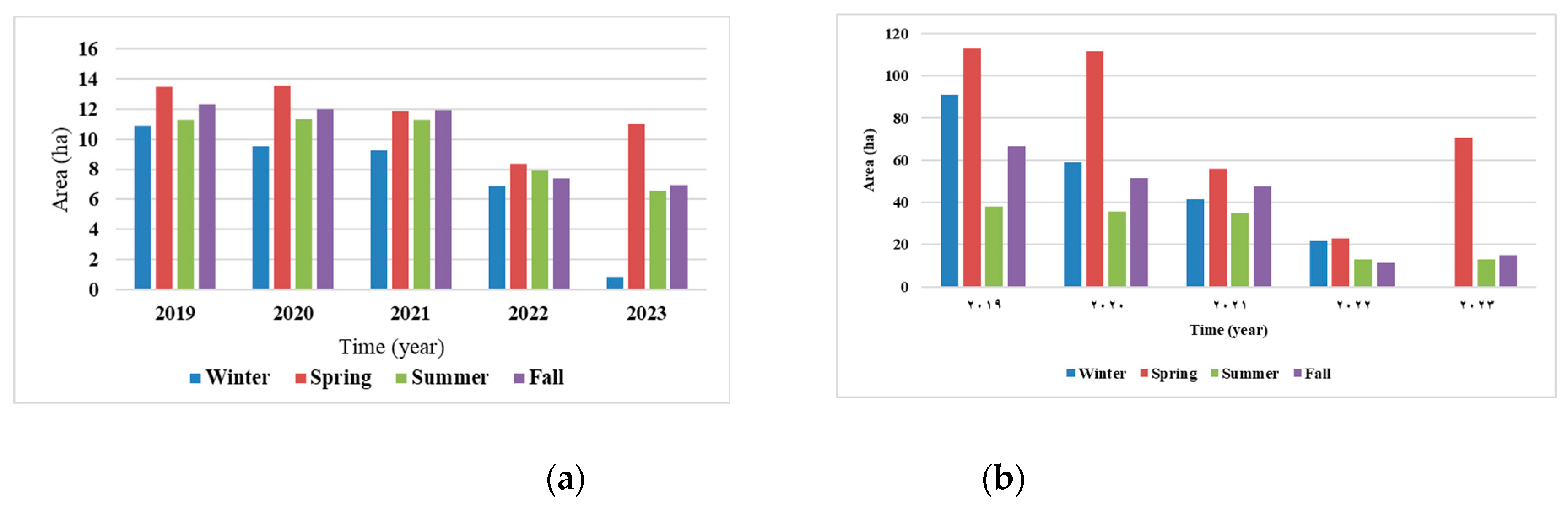
Figure 10.
Example of applying a specific threshold (NDVI ≥ 0.4) to assess the area of PUGSs; (a) Area = 58.66 ha; (b) Area = 12.69 ha. The red border indicates the boundary of the PUGS as defined in the SDUP.
Figure 10.
Example of applying a specific threshold (NDVI ≥ 0.4) to assess the area of PUGSs; (a) Area = 58.66 ha; (b) Area = 12.69 ha. The red border indicates the boundary of the PUGS as defined in the SDUP.
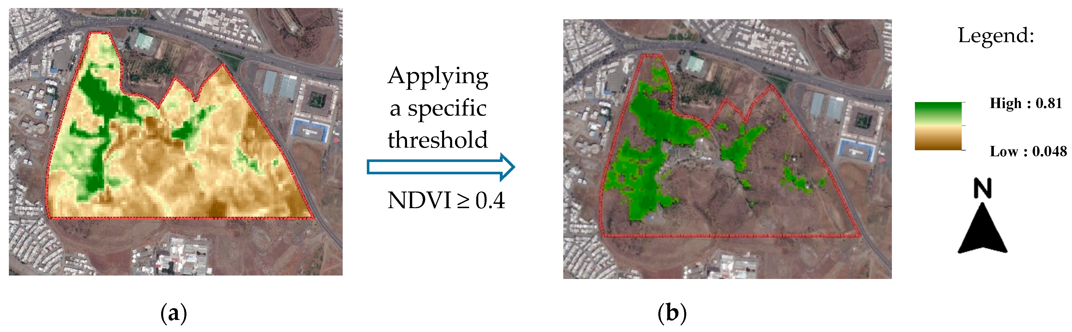

Table 1.
Monthly number of Sentinel-2A images of Sanandaj during the study period.
| 2019 | 2020 | 2021 | 2022 | 2023 | |
|---|---|---|---|---|---|
| Jan | 7 | 3 | 7 | 5 | 8 |
| Feb | 6 | 2 | 6 | 7 | 7 |
| Mar | 7 | 7 | 9 | 3 | 3 |
| Apr | 7 | 7 | 7 | 7 | 8 |
| May | 7 | 10 | 11 | 6 | 6 |
| Jun | 11 | 11 | 12 | 12 | 12 |
| Jul | 12 | 12 | 12 | 12 | 12 |
| Aug | 12 | 12 | 12 | 12 | 12 |
| Sep | 11 | 11 | 11 | 10 | 11 |
| Oct | 9 | 11 | 10 | 10 | 6 |
| Nov | 8 | 7 | 7 | 9 | 10 |
| Dec | 5 | 3 | 7 | 3 | 7 |
| Total | 102 | 96 | 111 | 96 | 102 |
| 507 | |||||
Table 2.
Number of PUGSs in Sanandaj classified by irrigation system type and major landscape categories (%).
Table 2.
Number of PUGSs in Sanandaj classified by irrigation system type and major landscape categories (%).
| Major landscape | MG | 9 (45%) |
| MT | 11 (55%) | |
| Irrigation system | SIS | 5 (25%) |
| FIS | 15 (75%) | |
| Total | 20 (100%) | |
Table 3.
Seasonal area changes of PUGSs in Sanandaj from 2019 to 2023 (ha).
| Winter | Spring | Summer | Fall | |
|---|---|---|---|---|
| 2019 | 102 | 126.9 | 49.2 | 78.8 |
| 2020 | 68.7 | 125.2 | 37.2 | 63.5 |
| 2021 | 51 | 67.8 | 46.3 | 59.5 |
| 2022 | 28.5 | 31.5 | 20.9 | 19 |
| 2023 | 0.9 | 81.8 | 19.5 | 21.7 |
| Total | 250.2 | 351.4 | 163.5 | 220.8 |
Table 4.
Changes in greenness (%) in PUGSs of Sanandaj from 2020 to 2023 compared to the baseline year of 2019.
Table 4.
Changes in greenness (%) in PUGSs of Sanandaj from 2020 to 2023 compared to the baseline year of 2019.
| PUGS | MG/MT | FIS/SIS | 2020 | 2021 | 2022 | 2023 | |
|---|---|---|---|---|---|---|---|
| Forest parks | Keshavarz | MT | SIS | 6.9 | - 93.3 | - 82.2 | - 70.1 |
| Neshteman | MT | SIS | - 5.8 | - 61.7 | - 73.7 | - 45.2 | |
| Pir Gharib | MT | SIS | 14 | - 62.7 | - 73.8 | - 46.4 | |
| Rusi | MT | SIS | 0 | - 54 | - 55.1 | - 35.9 | |
| Toos Nowzar | MT | SIS | 3.8 | - 67.2 | - 73.1 | - 21.4 | |
| Urban parks | Amiriyeh | MT | FIS | 8.6 | - 7.7 | - 10.9 | - 7.3 |
| Azadegan | MG | FIS | 0 | 0 | - 5 | 0 | |
| Cycling Road | MT | FIS | 0.1 | - 15.2 | - 13 | - 5.8 | |
| Halazouni | MT | FIS | 0 | 0 | - 10.1 | - 14.5 | |
| IT | MG | FIS | - 7.7 | - 17.4 | - 17.7 | - 20.2 | |
| Jahaad | MG | FIS | - 1 | - 6.8 | - 13.7 | - 8.8 | |
| Koodak | MG | FIS | - 8.7 | - 16.9 | - 21.4 | - 14.7 | |
| Mellat | MT | FIS | - 1.1 | - 2.1 | - 15.4 | - 10.6 | |
| Mohammadi | MG | FIS | - 1.5 | 0 | - 26.2 | - 13.4 | |
| Niro Entezami | MG | FIS | 3.7 | 6.5 | - 3.1 | - 5.3 | |
| Raoufi | MT | FIS | 3.1 | - 58.2 | - 64.5 | - 36.4 | |
| Shohada | MT | FIS | - 1.5 | - 10.1 | - 50.4 | - 18 | |
| Shohadaye 28 Dey | MG | FIS | 4.6 | - 33.7 | - 40.1 | - 23.5 | |
| 3 Khordad | MG | FIS | - 2.2 | - 3.4 | - 9.9 | - 8.4 | |
| 12 Farvardin | MG | FIS | 5.6 | - 10.1 | - 37 | - 14.9 |
Table 5.
Anomaly map of NDVI of PUGSs of Sanandaj from 2019 to 2023 1.
|
1 Green indicates the value > 0 and orange indicates the value < 0.
Table 6.
Water requirements of major species in PUGSs 1.
| PUGS | Major species | |||||||||||||||||||
|---|---|---|---|---|---|---|---|---|---|---|---|---|---|---|---|---|---|---|---|---|
| Forest parks | Keshavarz | Oriental plane | Ash | Arizona cypress | Arborvitae | |||||||||||||||
| Neshteman | Ash | Arizona cypress | Arborvitae | Mondel pine | ||||||||||||||||
| Pir Gharib | Oriental plane | Ash | Judas | Mondel pine | ||||||||||||||||
| Rusi | Ash | Black locust | Arizona cypress | Arborvitae | Bitter Almond | |||||||||||||||
| Toos Nowzar | Oriental plane | Ash | Arizona cypress | Arborvitae | Bitter Almond | |||||||||||||||
| Amiriyeh | Ash | White Mulberry | Elm | Arizona cypress | Arborvitae | Bitter Almond | ||||||||||||||
| Cycling Road | Oriental plane | Elm | ||||||||||||||||||
| Raoufi | Oriental plane | Ash | Black locust | Mondel pine | ||||||||||||||||
| Halazouni | Oriental plane | Ash | Elm | Mondel pine | ||||||||||||||||
| Mellat | Oriental plane | Ash | Elm | Black locust | Mondel pine | |||||||||||||||
| Shohada | Ash | Black locust | Judas | Mondel pine | Arborvitae | |||||||||||||||
| Azadegan | Kentucky blue grass | Oriental plane | Ash | Black locust | Glossy privet | Japanese quince | ||||||||||||||
| IT | Kentucky blue grass | Oriental plane | Barberry | Privet | Ash | Rose | ||||||||||||||
| Jahaad | Kentucky blue grass | Privet | Rose | |||||||||||||||||
| Koodak | Kentucky blue grass | Privet | Barberry | Rose | Arizona cypress | Arborvitae | Wild Pear | |||||||||||||
| Mohammadi | Kentucky blue grass | Oriental plane | Ash | Black locust | Rose | Arizona cypress | Arborvitae | |||||||||||||
| Niro Entezami | Kentucky blue grass | Oriental plane | Black poplar | Ash | Elm | Black locust | ||||||||||||||
| Shohadaye 28 Dey | Kentucky blue grass | Walnut trees | Paulownia | Arizona cypress | Arborvitae | Mondel pine | English Lavender | |||||||||||||
| 3 Khordad | Kentucky blue grass | Privet | Rose | Arizona cypress | Arborvitae | Deodar Cedar | ||||||||||||||
| 12 Farvardin | Kentucky blue grass | Ash | Black locust | Arizona cypress | Arborvitae | |||||||||||||||
1 Red, orange and light green show high, moderate and low water demand, respectively.
Disclaimer/Publisher’s Note: The statements, opinions and data contained in all publications are solely those of the individual author(s) and contributor(s) and not of MDPI and/or the editor(s). MDPI and/or the editor(s) disclaim responsibility for any injury to people or property resulting from any ideas, methods, instructions or products referred to in the content. |
© 2025 by the authors. Licensee MDPI, Basel, Switzerland. This article is an open access article distributed under the terms and conditions of the Creative Commons Attribution (CC BY) license (http://creativecommons.org/licenses/by/4.0/).
Copyright: This open access article is published under a Creative Commons CC BY 4.0 license, which permit the free download, distribution, and reuse, provided that the author and preprint are cited in any reuse.


