
Submitted:
25 February 2025
Posted:
26 February 2025
You are already at the latest version
Abstract
The comparison of equally important prerequisites of viticulture development (climatope and edaphotope) for its two historical regions has shown that both in the antique era and nowadays less favorable conditions of temperate climate (riskier in terms of frost danger) and poorer biogeochemical properties of soils and rocks in the steppe region compared to the conditions of the sub-Mediterranean region had a decisive influence on the volume and quality of wine products. This is supported by historical sources on local consumption of produced wine and imports of higher quality wine from Sub-Mediterranean vineyards (Tauric Chersonesos). Both regions of the Western Crimea are characterized by active bioaccumulation of iron, copper and manganese in the humus horizon of soils, which create a specific regional geochemical background with the prospect of approaching the ecological threshold of danger during long-term viticulture. The specific features of modern agricultural technology of viticulture lead to high concentrations of elements such as copper, vanadium, chromium and nickel, which can exceed the MPC levels 20-25 years after the vineyard is planted, earlier than other elements. This makes it possible to identify this list of heavy metals as a priority in the agroecological monitoring system for vineyard lands and sets the task of adjusting current agricultural technologies for sustainable viticultural practices in the specific soil and climatic conditions. The authors see prospects for further studies not only in improving methods for assessment of components of a wine terroir, especially biogeochemical parameters of soils and vine plants in a particular geographical area, but also in the technology for obtaining coupled integral estimates both in relation to edaphotope (stagnant environment (soil, parent and underlying rock) transformed by anthropogenic activity) and main products of viticulture and wine materials.
Keywords:
sustainable viticulture
; adaptive plant-growing
; terroir
; soil biogeochemistry
1. Introduction
The modern sustainable viticulture, in addition to the main economic goal of obtaining a stable crop with high quality conditions, focuses on the environmental and resource-saving imperative [1,2,3]. In order to optimization of agricultural environmental management, the soil fertility and productivity of farming ecosystems are efficiently regulated when implementing adaptive-landscape farming systems based on the principle of eliminating limiting conditions or adapting to them [4,5,6]. The adaptive landscape orientation of advanced farming systems has shown its efficiency in practice [7,8,9] due to adaptability of crop production to the morphological structure of the agricultural landscape, forms of management, levels of availability of material and energy resources and market conditions. According to some [10], when compared with other cropping systems, viticulture (winegrowing) is more conservative in terms of innovation due to its traditional focus on terroir. An important component of the modern agriculture is its adaptability, that is consideration of specific needs of physiologically close cultivated plants in relation to a certain package of environmental factors. When creating an adaptive plant-growing system, it is possible to ensure the maintenance of ecological balance in agroecosystems with a variety of parcel units of agricultural landscapes. The adaptive plant-growing intensification strategy assumes a more differentiated use of natural, biological, technological and labor resources in order to ensure the growth of agricultural production, as well as a number of functions (resource conservation, energy efficiency and environmental protection) [11]. The ampelo-ecological approach to assessing the landscape and its surrounding natural environment in order to determine a regional type of vineyard terroir and ensure the sustainable viticulture includes microclimatic characteristics [12,13], geological conditions [14], specific relief and hydrogeological conditions [15], soil properties [16,17], including the essential nutrients and trace elements contents [18] and integral assessments of natural resources and conditions [19,20]. Thus, the planning structure of future winegrowing plantations should be organically linked to the justification of external boundaries of the viticultural terroir zone [21,22,23,24] etc. Upon selection of location of a winegrowing plantation, the adaptation and resistance are already correlated with a certain variety (its reaction to the content of active carbonates, short-term waterlogging, drought, phylloxera and other local stress factors [25]). Both the vine plant itself and its individual varieties selectively extract specific assemblages of chemical elements from soils, their parent and underlying rocks that form a number of unique quality traits in wine, which detect the geographical area, the place and its natural resources within the terroir concept [26,27,28,29]. The soil and climate component of the terroir and cultivation technology is important for adaptability and high productivity; however, factors such as age of plantation, features of the root system, variety physiology, which determine peculiarities of fertilization, should be taken into consideration [30].
The relevance of this study and the choice of the appropriate subject of the study are determined by two main circumstances. Firstly, the adoption of the Federal Law on Viticulture and Wine-Making in 2019 (effective since 2023) stimulated the development of studies to assess the potential of the industry with identification of a package of key factors (economic, soil-climatic, anthropogenic), and also legislated the protection of geographical names of wine production sites [31,32]. Since the law obliges to assign wine products to the geographical area of their production, this requires parameterization of natural features for the previously identified 13 viticulture areas, and diagnostics of their uniqueness can provide some protection for originality of products from counterfeits. Secondly, the economic dimension is crucial when laying new winegrowing plantations with high productivity for several decades, which increases the role of responsible selection of location. The area of industrial use of the vineyard, the selection of its varietal composition, primarily determine specific conditions of the area (geological-geomorphological, lithological-soil, soil-ecological, and microclimatic specific features). This determines the need for a comprehensive analysis of specific characteristics of geographical areas of viticulture, using criteria according to the concept of terroir in viticulture [33,34,35,36]. Ampelocenosis, which relates to a perennial crop, changes the edaphotope more significantly than field crops, since it has beneficial effects on soil, water, biodiversity and climate, i.e. it has signs of regenerative agriculture [37].
In the future, the country has every opportunity to produce 70-85% of wine for its market from grapes grown on lands of its southern regions. One of these regions is the Crimean Peninsula, landscapes of which, along with significant soil and climatic diversity, have prospects of forming a wide range of terroir in five geographical areas to produce wine products with a strong individuality [38]. In addition, the high differentiation of environmental conditions at the meso level and micro level makes it possible to select an optimum terroir for formation of necessary grape conditions for particular purposes of use and contributes to cultivation of vine plants from very early to late varieties [39]. The area of grape plantings in the Republic of Crimea has already reached 20% of the area of vineyards in the country, or 21.7 thou ha, 83% of which are fruiting with the average yield of 6.4 t ha-1.
The forecast for improvement of ampelo-ecological conditions in the region also contributes to the intention to increase the area of vineyards. The simulation results for the entire Crimea have shown prospects for an increase in summer temperature from ~6 to 2.5°C by the late XXI century with a decrease in precipitation [40]. The age-old types of historical activities, which include cattle grazing, deforestation, etc., and especially formation of a root layer from soils and a lithogenic base for vineyards, should be regarded as a prehistory of transformation of soil genesis in landscapes of long-term agricultural use [41]. The result of use of previous viticulture practices, represented in soils left from antique times with relict evidence of agropedogenesis, as well as those re-involved in modern ampelocenoses, is interesting. The modern experience of ampelo-ecological studies in viticulture shows that, along with the terrain conditions (exposure, slope steepness, geomorphological niche, etc.) and microclimatic specific features of the area, the consideration of soil and environmental parameters is of great importance. New knowledge may be gained taking into consideration the fact that the age-old practice of viticulture on the Crimean Peninsula, associated with the colonization of the region's lands since antique times and the transfer of industry traditions from the Mediterranean, became undoubtedly more and more adaptable to local soil and climatic conditions and their changes. Tauric Chersonesos is a unique monument being a guide to scientific and practical achievements of the antique world and Byzantium, an example of skillful practices of adaptive nature management. One of such achievements is creation of the Chersonesos land boundary system, a typically Hellenic phenomenon, a result of the democratic structure of the ancient Greek polis, citizens of which received equal land plots. The land division has completely changed the natural and demographic shape of the Herakleian Peninsula (the southwestern tip of the Crimean Peninsula). In addition to the transformation of components of the natural environment, a cultural landscape has been formed here. It is presented today as a post-agrogenic archaeological landscape [42]. The cultural landscape, as a result of interaction of the changing natural environment and the socio-economic development of societies, forms a holistic vision of natural and cultural heritage [43]. The gained knowledge about historical and modern geographical areas of viticulture can serve as a fundamental basis for application of the "terroir" concept, which should be followed to obtain unique wine materials for the geographical expansion of the industry in the future.
The aims of the study were 1) to conduct a comparative analysis of the differences between two historical regions of viticulture in a wide range of soil-genetic indicators with the establishment of their specific features; 2) to establish through a comparison of vineyard terroir the reasons for the differences in the role of viticulture and winemaking in the economy of the two compared regions, known from ancient sources; 3) to substantiate a list of diagnostic soil terroir indicators for temperate climate conditions and the Sub-Mediterranean for sustainable viticulture practices.
2. Materials and Methods
2.1. Study Area Characterization
The territory of the Crimean Peninsula, although relatively small (26,100 km2), has both high bioclimatic diversity (20 agroclimatic regions from steppe to subtropical landscapes) [44] and soil diversity (42 soil species [45]), which is reflected in the wide range of values of climatic costs of energy on soil formation from 800 to 1200 MJ m-2 [46]. This provided a natural basis for formation of a long history of viticulture (beginning with the Greek colonization of the coastal areas in the 6 century BC) in a variety of natural and climatic conditions.
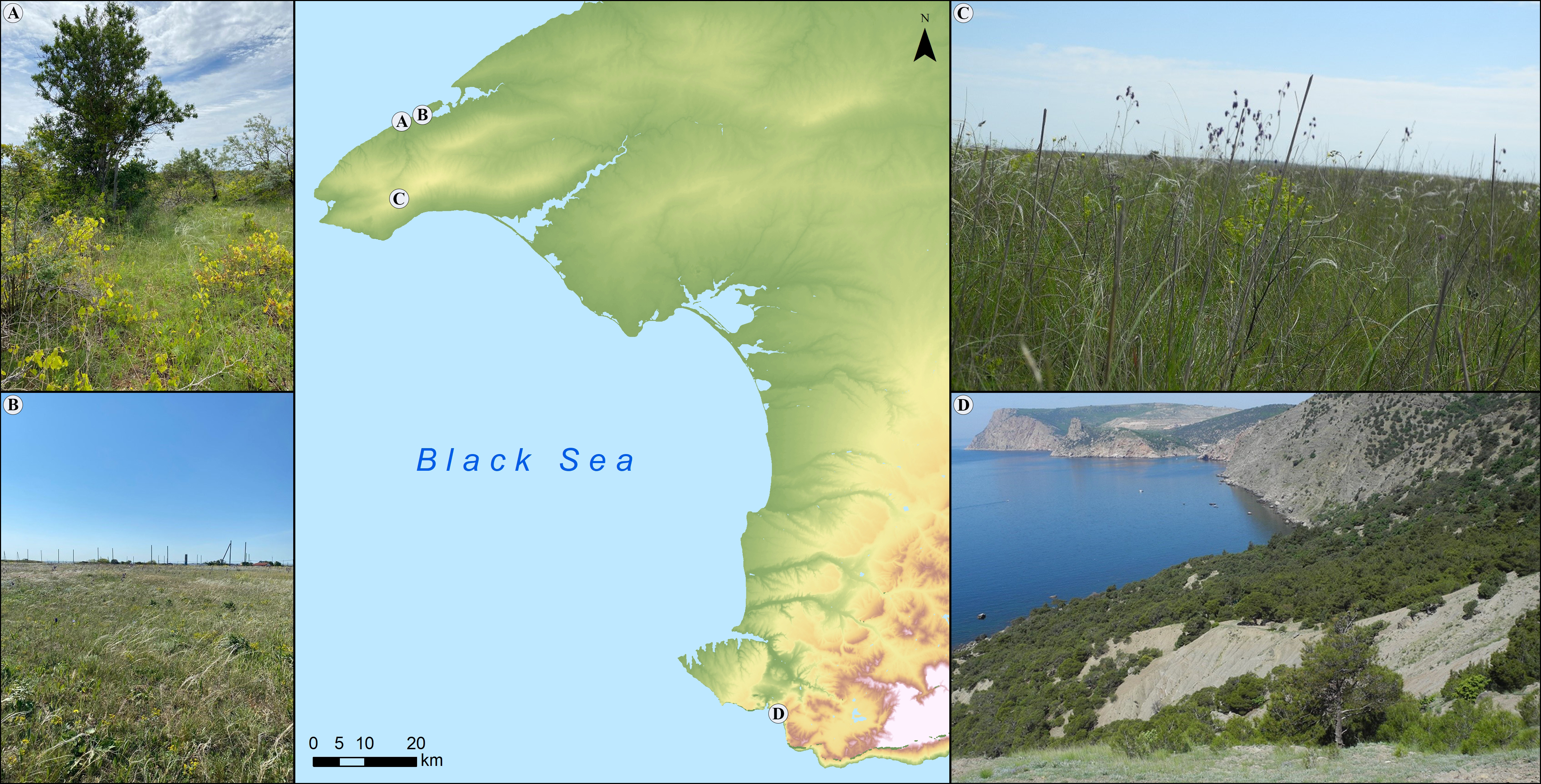
The results of long-term archaeological research on the peninsula have shown the widespread development of ancient viticulture and wine-making (Figure 1), in particular in the southwestern part, known as the Chora of Tauric Chersonesos (on the area of over 10,000 ha [48,49]), in the northwestern part (near 8 estates [50,51]) and in the east [52], p. 54. However, the South Coast with a subtropical climate, lands of which are most involved in viticulture today, was not agriculturally developed by the Greeks in ancient times due to confrontation with the peoples of the mountainous peninsula. The purpose of this study has been focused on age-old (historical and modern) areas of viticulture. In view of the fact that the area of the South Coast (east of the Herakleian Peninsula) was not developed by the Greeks to grow this crop, and there are very few plantings in the east (Kerch Peninsula) now (only 6 land users were employed in this industry in 2024), this study has been focused on the southwestern part (Herakleian Peninsula) and the historically related northwestern part (Tarkhankut Peninsula) of the Western Crimea.
By the second half of the 4th century BC, Tauric Chersonesos had involved a huge land stock in the Southwestern Crimea (Herakleian Peninsula) in economic turnover; and viticulture in the near agricultural district (chora) and the far chora was designed for production of red and white wines, including for export to the near regions of the antique and barbarian world, but it became gradually inferior to other branches of the agricultural sector at the turn of the century. European Bosporos (Kerch Peninsula) measures its viticultural history from the 5th century BC, and especially the 4th-3rd centuries BC, when special wineries with surrounding vineyards appeared, and up to the 3rd century AD [53] (Figure 2). The antique viticulture in the Eastern Crimea was developed in the area of small towns of the Bosporos Kingdom, as evidenced by artifacts from archaeological excavations (grape knives; press-beds (Figure 2)) and by results of studying the land division for vineyards at the Greek antique estate [54]. The modern viticulture is not a significant industry in the European part of the antique Bosporos Kingdom, unlike its Asian part, which corresponds to the west of the Krasnodar Territory with the total vineyard area of 30,000 ha.
2.2. Ancient viticulture regions in Western Crimea
The largest center of ancient viticulture and winemaking in the Northern Black Sea region was Tauric Chersonesos \, and wine was the main export commodity of this Greek city in the 4th-3rd centuries BC. The agricultural district of the Herakleian Peninsula functioned from the period of the foundation of Greek estates (5th century BC) until the beginning of the 1st century AD. The large-scale expansion of the rural district of Chersonesos in the 4th century BC on the Herakleian Peninsula (12,000 ha) allowed the demarcation of 10,000 ha of land into more than 430 large plots. In the first centuries AD, about 6,000 ha were occupied by vineyards in the near chora of Tauric Chersonesos [55], p. 12.
On those land plots of the Herakleian Peninsula, where continuous ditching was used for vineyards, a trench 70-80 cm deep was created, with extraction of stones for construction of ditch walls, with the width of about 2 m between them. As a result of such ditching, the agricultural soils inherited the geochemical features of eluvium of dense carbonate rocks. It was Tauric Chersonesos (with its success in agricultural technology) that, in antique times, acted as a constant donor of spread of traditionally southern crops as the western outpost of the Crimean South-Coast sub-Mediterranean area, suitable for introduction of crops from the Mediterranean regions useful to humans. The period of creation of perennial plantations in the rural area of the Northwestern Crimea was conditioned by inclusion of this region into the Chersonesos State by the turn of the 4th-3rd centuries BC. Traces of the ancient land division for horticulture and viticulture were found in eight places in the Northwestern Crimea, including in the vicinity of the town of Kalos Limen on the Tarkhankut Peninsula [56]. The assessment of the volume of wine production in the Kalos Limen district allows to judge its purpose to a certain extent: for local consumption. In addition, according to ethnographic data from later times, wine from the steppe regions was inferior to those varieties that were cultivated in the sub-Mediterranean conditions. In antique times, Greeks liked strong sweet wines [53], but the specific conditions of the Northwestern Crimea apparently did not provide favorable conditions for that, as evidenced indirectly by supply of wines from Chersonesos to that territory.
2.3. Field stage of soil study
The geographic coordinates of soil sections were determined using the WAAS GPS receiver. The classification status of soils was determined by ranges of large-scale soil maps and descriptions of soil sections using the International soil classification system [57]. The main soil sections are located in two areas of Western Crimea: on the Tarkhankut Peninsula (different-time postagrogenic soils after vineyards and their virgin analogues in the steppe zone (6 sections)) and the same sites on the Herakleian Peninsula in the sub-Mediterranean conditions (4 sections, including virgin steppe and primary forest) (Figure 1). The main horizon of the field study was the humus-accumulative horizon (horizon A), from which a sample below the sod-forming horizon (on average 3.5 (1.5-4.7) cm) to the lower boundary of horizon A (on average 20 (16÷33) cm) was taken for the chemical analysis. Taking soil samples for the agrophysical analysis included removal of undisturbed volume for subsequent sieving of air-dry soil into structural units. The bulk density was determined by the cutting-ring method followed by drying the soil at 105 °C in a thermostat for 6 hours. The authors used numbering of land plots of the antique Chersonesos according to the land division plan [Nikolaenko-06], which got an accurate geographical reference based on various aerial photographs and satellite images [59].
The large-scale modern development of the territory, which corresponds to the former rural district of Chersonesos, does not allow to explore a significant number of ancient land plots. The detailed analysis of satellite images showed that only 21 blocks of antique Chersonesos land plots out of their total number (430) had been preserved, by as many as half, by 2010 [59]. Therefore, in 2022, in 11 of the best-preserved land plots in the chora of Chersonesos, soil samples were taken in postagrogenic horizons to the depth of 19.4 (14.5÷21) cm for geochemical analysis. Typical parent rocks were taken from the depth of 123 cm (loess-like loam) and 64 cm (limestone eluvium on a monolithic platform).
The type of phytocenosis was determined by botanical determination of dominant and sub-dominant species using standard plots measuring 1 m x 1 m. The standard table for visual estimation of ground cover in increments of 10% was used to determine the projective coverage of aboveground phytomass (plant cover). The degree of rockiness of the soil surface (coverage, %) was determined in a square of 1 m x 1 m by the sum of measurements of the length and width of stones >5 cm in size.
The annual energy inputs for pedogenesis (Q, MJ m-2) in the viticulture regions was calculated using the Volobuev formula [60], which takes into account the differentiated contribution of heat resources (through the radiation balance) and moisture (through the sum of precipitation). The Huglin Heliothermic Index (HI), specialized for the needs of viticulture, was used for key weather stations in the winegrowing regions [61], which characterizes the level of heat supply and determines the sorting of vineyards and the specialization of the wine industry. The adaptive potential of a region for cultivating various grape varieties can be estimated by calculating the Huglin index, which integrally takes into account the average daily and maximum air temperatures and the average length of the day during the growing season [62]. The values of the Huglin index were taken from the work [47], in which they were calculated for basic weather stations in each of the four regions of the Crimean Peninsula.
2.4. Physical indicators of soils
The estimation of rockiness in the soil profile was obtained by sieving the soil mass from a prism with sides of 10 cm and a depth of 30 cm, from which crushed stone ranging in size from 2 to 10 mm, 1-5 cm and >5 cm was extracted through a sieve column, and the mass of the fractions was weighed in the field using the Techno TS electronic scale (with the accuracy of up to 1 g). The stone mass fraction was calculated taking into consideration differences in the density of soil layers in horizon A. Structural units in the soil were differentiated using a set of sieves from the Analysette 22 MicroTec laser light scattering particle size analyser kit (Germany, Fritsch GmbH). The analysis of waterproofness of macroaggregates by gradations of diameters 1-2, 2-3.15, 3.15–5 mm was made by estimating the decay rate of aggregates (n = 50) on moistened filter paper in a Petri dish according to the time recommended in the method [63].
The soil, ground with a rubber pestle and spread on a light brown substrate, got a color code in daylight, first in a moist condition, and after drying in a dry condition using the Munsell -System [64].
2.5. Specific magnetic susceptibility of soils
The values of the specific magnetic susceptibility (χ, 10-8 m3/kg) were calculated based on measurements using the Kappabridge KLY-2 instrument. The sieved soil was weighed and the volume magnetic susceptibility was measured in three repetitions. The indicator χ was calculated using the formula: χ =χv/m, where χv is the volume magnetic susceptibility and m is the mass of the sample [65].
2.6. Agrochemical indicators of soils
All analyses of this group were obtained at the accredited laboratory of the "Belgorodskiy" Agrochemical Service Center. Using state standards, the cation exchange capacity (CEC), mass fractions of mobile phosphorus and potassium, mobile compounds of copper, boron, molybdenum and pH of the aqueous extract were determined. Soil organic carbon (SOC) concentrations were determined by Tyurin's method (by oxidation of the organic substance with a solution K2Cr2O7 in sulphuric acid); the mobile organic matter content was determined by Egorov's method; soil total nitrogen (TN) concentrations were determined using the Kjeldahl method; and alkaline-hydrolysable nitrogen in soil was determined by the Kornfield method [66].To assess the soil organic matter (SOM) reserve during the formation of humus, soil with roots was removed from the sod-forming horizon (Ad), and, in laboratory conditions, a mass of detritus was extracted by flotation in hot water, the proportion of which was determined from the air-dry mass of the soil (without stones).The chemical composition data of soils were determined with acceptable errors using the approaches adopted in such instances [67].
2.7. Geochemical composition and indicators of soils
Wavelength-dispersion X-ray fluorescence spectrometer (Spectroscan Max-GV, “SPECTRON”, Ltd) was used to determine the concentration of 10 macroelements in the form of oxides (Fe2O3, Al2O3, TiO2, CaO, SiO2, MgO, MnO, P2O5, K2O, Na2O) and 12 microelements (As, Ba, Co, Cr, Cu, Ni, Pb, Rb, Sr, Zn, Zr, V) in powdered soil samples. The geochemical composition in each soil sample was determined in two repetitions. The quantitative calibration was made using a set of state standard samples of soil composition. If there were unacceptable discrepancies between the results of the first and second replications, which was detected in the spectrometer software, subsequent repetitions were performed until an acceptable result was achieved. The methodology is approved for the purposes of state environmental control and monitoring.
The data on the reference section (virgin protected steppe), which represented the chemical elements content of structural units >1 mm, <1 mm, <0.5 mm, <0.25 mm in size, allowed to calculate the coefficients of enrichment and depletion of chemical elements in the natural trend of pedogenesis. The geochemical composition was also determined for typical parent rocks in two areas of the study: 1) loess-like loams (northwestern area) and 2) limestone eluvium (both areas). Based on the classification [68], a list of 12 macro- and microelements useful for plants in postagrogenic soils and their virgin analogues was used (Ca, Si, Fe, Mg, Mn, K, P, S, Cl, Ni, Cu, Zn). Some of the remaining chemical elements (Al, Ti, Na, V, Cr, As, Rb, Sr, Zr, Ba, Pb) were used to assess the level of pollution by heavy metals and to calculate the most informative geochemical indicators reflecting the main processes of pedogenesis. Since the national standards of maximum permissible concentration (MPC) for soils do not take into consideration genetic characteristics of soils in local conditions of pedogenesis [69] and, in our case, exceed much the average content of heavy metals and metalloids (HMM) from local standards (soils of protected areas), for Mn by 25 times, for Sr, Zn, V, Cr, Ni, As by 4-2 times, the authors used the values of the regional geochemical background (RGB) for the two studied areas to assess the soil pollution (sections 30 and 43). The assessment of the pollution of fallow soils by 11 HMM (As, Ba, Cr, Cu, Fe, Mn, Ni, Pb, Sr, V, Zn) was calculated as the average value of the coefficients of excess of concentrations over the values of the regional geochemical background. The wide range of geochemical coefficients, already successfully used to diagnose many soil processes [70], was adapted by us to the specific bioclimatic situation of the study area [71]. The coefficient of biological accumulation in relation to the parent rock was determined by an assemblage of elements (K, P, Ca, Mg, Mn, Fe, Ni, Zn) according to [68], excluding copper, the content of which in vineyards depends much on the role of modern agrotechnical practices. To assess chemical weathering in soils, two basic oxides (SiO2 and Al2O3) were used in this type of assessment, with the eluviation coefficient in the numerator, while the denominator was the sum of alkaline oxides (CaO, MgO, MnO, K2O, Na2O).
The gross composition data for chemical elements and oxides were converted through conversion coefficients into element concentration values, eliminating the different contribution of oxygen atoms in oxides (the conversion coefficients ranged from 0.44 to 0.83). Therefore, we obtained the integral soil quality (SQ) estimate after preliminary recalculation of the element content from the values of oxides. The integral soil quality (SQ) score was obtained using the Storie formula [72], which takes into account the contribution of limiting factors when calculating the geometric mean, and was successfully applied to soil rating [73].
3. Results and Discussion
3.1. Climatotops of two regions of Western Crimea
In the ampelo-ecological classification of lands [74], it is the climate and its limiting factor (minimum air temperature with the repeatability of 10% or more) that determine the highest level of a taxon. For the special conditions of the northern zone of industrial viticulture, this determines not only the durability of plantings, but also grapes and wine taste scores [75]. The soil-amelioration state of the land, the nature of the terrain, the sum of active temperatures, and the genetic parameters of the soil consistently form taxons at lower levels.
The long history of grape breeding, adapted to local conditions, began already in the 6th – 5th centuries BC (Bosporos and Tauric Chersonesos), having gone from the local wild grape variety of Vitis sylvestris to its domesticated form known as Vitis vinifera [76], p. 127. In addition, the dynamics of the period of antique agriculture was largely determined by climatic rhythmicity, since, after the end of the relatively wet climatic period by the 4th century BC, a hot, dry climate with a strongly-pronounced continental appearance established in the 3rd century BC, and the arid epoch did not end until the second half of the 1st century BC [77]. The Hellenistic period (4th-2nd centuries BC), during which such processes as intensive multi-profile crop production, regulated by land division systems (field and perennial plantations), introduction of Mediterranean crops, formation of commodity sectors in agrarian production were clearly manifested, occupies a special place in regional historical and geographical periodization. A rather long frost-free period, reaching 220-250 days, is typical for the Northwestern Crimea. Frosts stop in spring in the third decade of April. Frosts can be very significant in winter; and, with strong winds, the low-power snow cover is blown away. The optimum moisture balance during the growing season and the provision of heat correlate with the geographical localization of today's world-renowned wines. The Herakleian Peninsula, which is 120 km south of the Tarkhankut Peninsula, has a climate with higher mean annual temperature (by 1.8 °C), sum of temperatures >10 °C (by 145-210 °C), which is cumulatively represented in a 100 MJ m-2 yr-1 excess in climatic energy inputs for pedogenesis (Table 1). This expands the range of suitable grape varieties and makes viticulture in the Southwestern Crimea more resistant to stress. The Southwestern Crimea (Herakleian Peninsula) is a very distinctive region in natural and climatic terms, which belongs to the western foothill agroclimatic region, only in the east of which the South-Coast sub-Mediterranean area region begins. One of the important indicators of stable soil-climatic conditions, which represents the northern border of the sub-Mediterranean, is the area of such a representative for the Balkans, but rare for the conditions of the Crimea, tree as Pistacia (Pistacia mutica Fisch. et C. A. Mey.). Since Pistacia grows in the Crimea at mountain heights up to 400-440 m a.s.l., withstands frosts up to -30 °C, and the age of century-old trees here reaches 900-1500 years [78], this is indicative of a significant ecological plasticity of this species. This species is widespread not only along the South Coast of the Crimea for 200 km and on dry slopes on cinnamonic brown soils, but also in the western part of the foothills (from Sevastopol to Bakhchisarai). The results of geobotanical surveys record 17 Pistacia habitats directly on the Herakleian Peninsula. Since this species is contiguous with the brown soil habitat and its life span is 200-300 years and sometimes reaches 1,000 years [79], it diagnoses well the stable bioclimatic potential of the mentioned areas as bordering on the climate conditions of temperate latitudes to the sub-Mediterranean. It is noteworthy that pollen and soil stratigraphic sequences showed the appearance of Pistacia until around 7 ka, due to the formation of favorable (warmer) conditions for it [80]. The key agro-climatic parameter (average temperature in January) makes it possible to determine possibilities of cultivating groups of grape varieties in terms of frost resistance, the widest range of which can be used in the South Coast of the Crimea and in Greater Sevastopol (Herakleian Peninsula). Judging by the length of the frost-free period, late varieties can be successfully cultivated in these regions. The threats of the latest spring frosts limit the possibilities of early varieties in the Eastern Crimea, but especially in the Northwestern Crimea, where waves of cold air often come from the north. This is also represented in the lowest values of the Huglin index for the entire territory for the Northwestern Crimea. If in the sub-Mediterranean zone of the Crimean Peninsula the average absolute minimum temperatures range from -7 °C to -10 °C, then on the steppe plains (North-West and East of the Peninsula) the range of these values is more significant (from -15 °C to -23 °C). The energy potential of pedogenesis, which is estimated by basic climatic parameters, is the highest for the sub-Mediterranean zone of the Crimean Peninsula, and its significant values characterize the area of brown soils in the Southwestern Crimea. If we compare the climate of the winegrowing regions of the Crimea with the countries of the Mediterranean Europe, then even the South Coast of the Crimea (SCC), which is protected by mountains in a narrow strip up to 15 km wide, has a cooler climate (with the average temperature of the coldest month +2.9 ÷ 4.1 °C (II), and the territory is classified as subtropical, if the range of this parameter is from 0 to +5 °C, although the heat resources are less than the sum of temperatures (4,600 °C) of the threshold value for classification as a true subtropical climate).

Table 1.
Main agroclimatic parameters of the regions on the Crimean Peninsula.
| Climate parameters | Regions | |||
|---|---|---|---|---|
| North-West | South-West | East | South Coast of Crimea |
|
| Average t (I), °C | +0.3 ÷ -1.8 | +1.6 | +0.3 ÷ -1.5 | +1.8 ÷ +4.0 |
| Frosts (last of spring) | 15-20.04 | 25.03 | 10.04 | 15-25.03 |
| Frost-free period, days | 186-223 | 240 | 214-220 | 237-259 |
| Precipitation for the period from t > 10 °C, mm | 190-216 | 177 | 195-220 | 195-260 |
| Huglin index [47] | 2403 | 2502 | 2571 | 2546 |
| Q, MJ m-2 yr-1 | 900-1000 | 900-1100 | 900 | 1200-1400 |
Q is annual energy costs for pedogenesis.
The special challenge of terroir parameterization arises when moving from vineyards on flat surfaces to their placement on slopes. In terms of energy resources, the southern slopes are the most valuable, while the northern, northwestern and northeastern ones, with a decrease in the radiation balance to 10% relative to flat areas, are classified as cold slopes. And in hilly areas, open valleys from 5 to 100 m deep have a frost-free period 16-25 days shorter, and spring frosts occur 6-10 days later [81].
The background estimates of the spatial distribution of energy consumption for soil formation, obtained for the region, can be differentiated for the low-mountain landscape level by using adapted methods for calculating heat and moisture distribution for terrain mesoforms using GIS technologies.
3.2. The role of selection for climate adaptation in the formation of wine terroir
Ancient winegrowers faced the task of using the knowledge of that time and empirical experience of variety testing to select grape varieties adapted to local soil and climatic conditions. This task could be performed either by using varieties of local origin (indigenous varieties) or by using them as rootstocks. The results of paleobotanical studies [82] have determined that, in the Crimea, the Greek antique viticulture began with the adaptation of wild vines, and only later imported vines from the Mediterranean were introduced. On the Herakleian Peninsula, the local wild grape variety was initial for the breeding work. Grape forest (Vitis sylvestris C.C.Gmel.) as an indigenous species is found in the Crimea on the northern slope of the mountains in oak forests, and its berries usually have the diameter of 7-8 mm; however, in a small area of the foothill there is one form (f. macrocarpa) with large fruits and seeds (10-11 mm long and 7-8 mm wide) [78].
The study of the origin of endemic and relict grape forms, as well as the creation of an ampelographic collection (as at the Magarach Institute, consisting of 80 indigenous Crimean grape varieties) proves that a number of indigenous varieties are truly autochthonous, which belong to species Vitis vinifera and various eco-geographical groups of Eurasia [83]. In the northern viticulture, the adaptive potential of grapes in the conditions of stressful winter temperatures is assessed using abilities of native varieties of native varieties as sources of high adaptive ability to negative temperatures [84].
Taking into consideration the fact that the southern coast of the Crimean Peninsula is located on the northern border of the subtropical zone, and the south of Crimea currently belongs to the type of a sub-Mediterranean landscape, ancient farmers were forced to form an agrotechnology of viticulture adapted to both the peculiar climatic conditions and the biogeochemical characteristics of local soils. In the course of breeding, it was important to use native varieties that provide the "descendants" with a greater degree of adaptation to frost, while maintaining the ability, despite climatic differences, to accumulate, for example, a similar anthocyanin complex [85,86]. The history of ancient winegrowing was often investigated by the remains that were adsorbed on the walls of amphorae, but a unique opportunity was provided by the discovery of 2,000-years old wine in the liquid state with its composition of polyphenols and the mineral salt profile [87]. Consequently, the development of reliable methods for classifying grapes and wine materials [88,89,90] and detecting adulteration is becoming an important analytical task and it involves the identification of terroir in the soil-geochemical aspect.
Geochemical features of translocation of elements in the "soil-plant" system based on results of studying the geographical regions of Crimean viticulture [91] have shown that the content of macro- and microelements that can accumulate in vine plants, including berries, plays an important role in formation of taste parameters of wines. Establishing a link between the geochemical properties of the soil and the taste of wine will help find criteria for identifying geographical areas.
3.3. Anthrosols of ancient viticulture.
The ancient system of land division, which has often been preserved in the modern landscape, especially when they are identified using remote sensing, has been described in terms of planning structure [92,93,94,95]; however, agro-soils in isolated plots of land have been little studied by modern methods of soil science [96,97] Given the differences between physiologically heterogeneous crop production, including perennial plantings (orchards and vineyards), and their requirements for soil fertility resources, human activities lead to formation of a special group of agrogenic soils with a defined range of properties – Anthrosols [98] or, in another way, Anthroposols, Anthropogenic or Man-made soils [99]. Anthropogenically transformed turbated soils occupy a special position (in genetic, classification, evolutionary relations).
Soils formed on the eluvium of carbonate rocks are widely represented in the northwestern Crimea (56% of the area). These are Haplic Chernozems and Calcaric Chernic Rendzic Phaeozems, which are underlain by a limestone slab from 40–55 cm. In the Northwestern Crimea, several areas with preserved antique land management have been discovered, since ancient farmers used ditching for perennial plantings due to their proximity to the surface of the bedrock. Thus, antique vineyards of good preservation were found 1.2 km northeast of the antique center of Kalos Limen (early 4th century BC – early 2nd century AD and near the estates of Oirat and Mamai-Tyup (second half of the 4th–3rd centuries BC).
The most extensive transformation of soils by ancient farmers, taking into account the entire territory of the Crimean Peninsula, was carried out precisely on the lands of the Herakleian Peninsula. The weathering products of carbonate rocks act as parent rock for Cinnamonic (Cambisols Calcic) soils (based on the World Reference Base (WRB)), which were formed on the lower floor of the Sub-Mediterranean Low-Mountain Landscapes with dry forests and shrubs [100]. These soils are most suitable for growing grapes and essential oil crops, and the lower coastal areas of South Crimea are predominantly occupied by agricultural lands featuring vineyards and cultivated fields [101].Due to the fact that bioclimatic changes in the landscape of the sub-Mediterranean type were in the invariant zone, starting from the Pliocene and throughout the Holocene, the ancient and modern processes of pedogenesis proceeded syngenetically [102]. The South-Cost soils, which were shielded by the Main Ridge of the Crimean Mountains during the Ice Age, like other Mediterranean landscapes of low mountains [103], were formed continuously and have a long-standing zero moment of pedogenesis. The landscape in the regions of centuries-old agriculture, especially where ditching was used for perennial plantings, has heterochrony, i.e. it has not one reference point (zero moment) of formation of its current state, but several such zero moments [104].
The ancient land managers and agricultural technicians of the Chersonesos land division system not only built dividing walls for the individualization and identification of land plots as a territorial basis for exercise of the rights of land users and landowners in rural areas, but actually created a completely new natural and economic territorial system, in which, first of all, a special soil profile, adapted to the cultivation of perennial plantations, was transformed, or rather created. The main transformations concerned the ditching transformation of the natural dominant soils of grass-steppes and forest-steppes on elevated outwash plains and in the draw network and the creation of a new type of soil profile to the depth of 60-80 cm, adapted for growing vine plants and fruit crops. In fact, antique farmers formed a new type of soil in some land plots, which can be called agrogenically transformed soils with turbation features in the agroheterogeneous horizon.
3.4. Agrophysical characteristics of wine soils
The phenomenon of secondary (restored) steppe successions in postantique landscapes lies in their most adequate representation of the bioclimatic potential of the area during the period of the restoration conditions [105,106,107,108]. However, the delay in the regenerative evolution of postagrogenic soils in comparison with the restoration of phytocenosis [109,110] is represented, for example, in the fact that the total projective coverage on fallows is 10-30% lower than that of virgin steppe (Table 2). The bulk density below the sod-forming horizon is set at 1 g/cm3, regardless of the type of land (Table 3). Our field measurements have shown that the proportion of submerged stones, which were originally on the arable surface, was 72-79% by volume over the 21st-23rd centuries of the fallow conditions, whereas no gravels are observed in virgin steppe (Table 4). Most of the soils in the study area are gravelly to one degree or another, especially those selected for viticulture. These are Neogene limestones different in density and coloration. On fallows, the projective coverage of stones is estimated on average as 3% (from 1% to 5%), whereas, on the mountain slope under the forest of sub-Mediterranean appearance, this indicator reaches 10% (Table 4). According to the regional scale, all sites are categorized as surface-weakly stony (less than 10% coverage with stones of at least 5 cm in size) according to the degree of rockiness of the soil surface (coverage, %). On the modern surface of the post-antique fallow at Kalos Limen, there are on average 46 limestone fragments with diameters of greater than 3 cm (gravels) per 1 m2. When studying vineyards in areas with stony soils, it has been noted [111], p. 300, that the presence of skeletal debris on the surface has a particularly positive effect, since stony mulch accumulates solar heat and, reflecting it, irradiates grape berries. It is known that, in perennial plantations (orchards and vineyards), due to the peculiarities of agrotechnics, soil erosion processes are actively developing. It is important to note that the effects of rock fragment cover on soil erosion were effectively reduced only with the fragment size <12 cm [112]. In terms of the mass of stones contained in a 30 cm thick soil layer and categorized as small stones (5-10 cm), sites 31, 32, 29, 26 and 37 stand out, all of which characterize ditched soils in antique land plots. According to the rockiness classification, soils 31 (47%), 32 (32%), 29 (28%), 36 (26%), and 34, 37 are classified as highly stony (with the >10% share of the diam. >3 mm fraction). Among the five stone fractions obtained (2 to 50 mm or more), gravels (1-5 cm), >5 cm, and 5-10 mm contribute the most mass in the studied soils (Table 4). As shown by our measurements, in the studied fallows, the shares of stone mass in the 30-cm soil layer with sizes of 1-50 mm and 5 cm are 43% and 22% respectively (Table 4). It is important to note that, if the skeleton (>1 mm particles) content of the root layer is 10 to 50%, the fertility of soils for grape does not decrease; and, only with the >50% share of skeleton, the fertility level may decrease from zero to 30% of the fertility of fine-grained soils with the >1 mm particles content of <10%.
Table 2.
Main objects of study in North-West and South-West Crimea.
|
No. section |
Coordinates | Location | Agricultural land | Phytocenosisa |
GPCb % |
Soilc | |
| latitude | longitude | ||||||
| Tarkhankut Peninsula | |||||||
| 29 | 45.529166 | 32.715770 | Rural area of ancient Kalos Limen | Post-antique fallow land (vineyard, plantation ploughing) | H+F | 80 | LPk |
| 30 | 45.529300 | 32.715475 | Coastal area near the section No. 29 | Virgin land (steppe) | H+Sc | 95 | CHk |
| 31 | 45.246011 | 33.467303 | Antique land plot у пoс. Мамай-Тюп | Post-antique fallow land (vineyard, plantation ploughing) | H+Sc | 80 | LPk |
| 32 | 45.322236 | 32.668159 | Antique land plot у пoс. Ойрат | Post-antique fallow land (vineyard, plantation ploughing) | Sc+H | 90 | LPk |
| 33 | 45.388269 | 32.695604 | Nature reserve “Krasnoselskaya steppe” | Virgin land (steppe) | Sc+H | 90 | CHk |
| 34 | 45.350074 | 32.703932 | 2.5 km east of section No. 32 | Abandoned cropland since 1980s. (vineyard) | H+(Sc+Sl) | 80 | CHk |
| Herakleian Peninsula | |||||||
| 35 | 44.485509 | 33.625644 | 2.5 km east of Balaklava Bay | Sub-Mediterranean forest | PJ+H | 40 | CMu |
| 36 | 44.572428 | 33.476739 | Antique land plot No. 153 | Post-antique fallow land (vineyard, plantation ploughing) | H+Sc | 80 | CMc |
| 37 | 44.534027 | 33.542985 | Antique land plot No. 378 | Modern fallow land (vineyard, antique plantation ploughing) | H | 60 | CMc |
| 43 | 44.493874 | 33.608177 | 0.9 km east of Balaklava Bay | Virgin land (steppe) | Sl+F | 90 | CMc |
a Phytocenosis type (dominant + sub-dominant): Pinus brutia Ten, Juniperus excelsa M.Bieb. (PJ+H); Stipa capillata L. (Sc); Stipa lessingiana Trin. & Rupr. (Sl); Festuca valesiaca subsp. valesiaca Gaudin (F); Herbs (H); bGeneral projective cover; cSoils: Chernozem calcic (CHk), Leptosol rendzic (LPk), Cambisol calcaric (CMc), Cambisol humic (CMu).
Table 3.
Density of soil aggregates and water resistance.
| No. section |
BD (g cm-3) | Water resistance (%) of soil aggregates with diameter, mm | Average (%) | ||
|---|---|---|---|---|---|
| 1-2 | 2-3.15 | 3.15-5 | |||
| 29 | 0.96 | 84.5 | 92.1 | 94.7 | 90.4 |
| 30 | 0.98 | 71.8 | 74.3 | 87.2 | 77.7 |
| 31 | 0.89 | 84.6 | 87.3 | 91.7 | 87.8 |
| 32 | 0.95 | 83.2 | 87.2 | 88.1 | 86.2 |
| 33 | 0.97 | 75.1 | 77.2 | 80.4 | 77.5 |
| 34 | 0.92 | 69.0 | 70.1 | 79.0 | 72.7 |
| 35 | 1.24 | 91.2 | 94.8 | 96.4 | 94.1 |
| 36 | 0.99 | 61.9 | 67.0 | 67.5 | 65.4 |
| 37 | 1.08 | 85.9 | 90.1 | 92.4 | 89.4 |
BD = bulk density.
Table 4.
Indicators of surface, organogenic horizons and humus state of horizon A of postagrogenic soils and their zonal analogues.
Table 4.
Indicators of surface, organogenic horizons and humus state of horizon A of postagrogenic soils and their zonal analogues.
| No. section |
GPCa (stones) % |
MS (1-50)b % |
MS (>50) b % |
Horizon Аd mm |
Detritus mass (horizon Аd) % |
Depth of selection from horizon A cm |
Munsell colour (horizon А) moist dry |
SOM % |
TN % |
Labile humus % |
С/N ratio |
|
|---|---|---|---|---|---|---|---|---|---|---|---|---|
| 29 | 2.0 | 22 | 28 | 30 | 1.31 | 3-16.5 | 10YR 4/3 | 10YR 5/4 | 3.27 | 0.24 | 0.01 | 7.9 |
| 30 | 0 | 1 | 0 | 45 | 8.90 | 4.5-16.5 | 10YR 4/4 | 10YR 5/5 | 3.63 | 0.28 | 0.05 | 7.5 |
| 31 | 1.9 | 31 | 47 | 25 | 6.62 | 2.5-27 | 10YR 4/3 | 10YR 5/4 | 3.51 | 0.23 | 0.05 | 8.9 |
| 32 | 2.7 | 21 | 32 | 37 | 0.75 | 3.7-16 | 10YR 4/3 | 10YR 5/4 | 4.18 | 0.27 | 0.06 | 9.0 |
| 33 | 0.1 | 4 | 0 | 47 | 0.25 | 4.7-17 | 7.5YR 3/3 | 7.5YR 3/4 | 3.64 | 0.25 | 0.04 | 8.4 |
| 34 | 1.3 | 25 | 0 | 40 | 0.26 | 4-33 | 10YR 4/4 | 10YR 5/4 | 2.20 | 0.16 | 0.04 | 8.0 |
| 35 | 9.7 | 6 | 0 | 36 | 44.85 | 3.6-19.5 | 10YR 4/3.5 | 10YR 6/4 | 4.91 | 0.27 | 0.05 | 10.5 |
| 36 | 4.8 | 31 | 26 | 35 | 1.46 | 3.5-20.5 | 7.5YR 3/4 | 7.5YR 4/4 | 4.41 | 0.32 | 0.05 | 8.0 |
| 37 | 3.5 | 55 | 17 | 40 | 0.84 | 4-21 | 7.5YR 3/4 | 7.5YR 4/6 | 4.20 | 0.24 | 0.06 | 10.2 |
| 43 | 0 | - | - | 15 | 2.99 | 1.5-17 | 7.5YR 3/4 | 10YR 5/5 | 3.02 | 0.22 | 0.05 | 8.0 |
aGeneral projective cover; b MS (1-50) and MS (>50) proportions of the mass of stones measuring 1-50 mm and >5 cm, respectively, in a 30-centimeter soil layer.
It is obvious that there is a close relationship between natural or anthropogenical enrichment of soil with crushed stones and carbonate fraction. The cinnamonic soils of this region are always characterized by boiling from HCl; however, the formation of a carbonate-accumulative diagnostic horizon with carbonate neoformations is noted only occasionally [113]. Carbonate black soils usually contain at least 23% CaCO3 in horizon A (Table 5). In modern perennial plantings of the Crimea (orchards, vineyards), where ditching is always carried out to the depth of 50-60 cm, the carbonate content in the upper horizon is 3-8%, and it reaches 16-19% in the carbonate-illuvial horizon [114]. CaCO3 content in horizon A of postagrogenic soils in the Northwestern Crimea averages 26.70±2.62% (Table 6), and in Chersonesos it averages 29.71±4.33%, but may reach 43-49% (Table 7).
The characteristics of soil and rock formation up to 1-2 m are important when growing field crops, taking into consideration the rooting depth, while the ampelo-ecological assessment may not be limited to this, since grape roots can penetrate to the depth of up to 6 m, including through cracks in dense rocks. To evaluate the land plots of wineries within the terroir concept, the use of parametric methods has shown the need to evaluate not only the surface horizons of the soil, but also deeper layers [115]. The viticulture practice shows the positive role of the soil skeleton, which promotes aeration and provides good water permeability. On loamy rocks, in addition to the surface zone of the rhizosphere, the maximum total number of roots is at the depth of 100-140 cm, and 160-200 cm for absorbing roots. It has been previously noted [111], p. 301, that the special flavors of wines depend on the content of rare dispersed elements in them, some of which can be extracted by vine plants from the underlying rocks. The introduction of rocks in the course of ditching may also lead to biogeochemical enrichment of the root layer.
The 4,500-m2 site, recently discovered by geomagnetic survey in the Northwestern Crimea near the town of Kalos Limen, provides great information opportunities for understanding the agrotechnology of antique viticulture [56]. As can be seen from Figure 3, a part of the land site is occupied by wide (10 m on average) and part by narrow (1.5 to 2.2 m) plots. Such differences are explained by the fact that, in the antique era, lands for perennial plantings (orchards and vineyards) were created using ditching for two types of plantings: vinea (the vine was reinforced on stakes and trellises) and arbustum (the vine was wound along fruit trees), with the distance between the walls of 2 and 5 m respectively [51,56]. N.I. Vavilov, a researcher of wild and cultural flora, noted that in the 1920s, in some areas of viticulture in Western Afghanistan, vines were on trees, and grape wrapped around fruit trees in the form of liana [116], p. 469. Based on the soil and climatic specific features of the region near Kalos Limen, one of the most adapted trees could most likely be almond (Prunus dulcis), which was cultivated by Greek colonists. It is noteworthy that almond appears in modern abandoned vineyards.
Here, the underlying rock of the soil profile is Upper Sarmatian limestones, which are found on the cliff as early as 0.7-1 m (Figure 3c). 22 m from the 70-m long trench in the vineyard (Figure 3b), a section of virgin soil has shown that this is carbonate medium-loamy crushed black soil on the eluvium of dense carbonate rocks. Limestone fragments up to 2 cm in size are found in the profile from 65 cm, and their greatest occurrence is from the depth of 102 cm. Below is a heavy loamy rock, unchanged by soil formation, with abundant limestone crushed stone (up to 5 cm in size and angular in shape). In the narrow (2 m wide) rows of the vineyard (Figure 3a), crushed stone with the diameter of >3 mm, weighing 448 g/m2 (4.5 t/ha), was selected using a sieve method among rock fragments of various sizes and shapes lying on the surface and partially immersed in the soil (up to 4 cm). Soils ditched in the antique era were classified as low-stony in terms of stone content (the proportion of stones was 2.9% by weight and 4.7% by volume). By rockiness, which is characterized by the total volume of stone (more than 5 cm in diameter), the soils are classified as low-stony, since they contain 2 m3 ha-1 stones; however, this assessment is applicable only to the 0-5 cm layer of fallow soil. By sampling the upper layer of the rock, antique vine growers formed a trough-shaped trench, which was filled with loose soils and fine rock. The soil profile between the plantation walls had crushed stone layer at a depth of 31–43 (up to 57) cm with stones ranging in diameter from 3 to 13 cm. There is a crushed stone layer in the soil profile between the ditch walls at the depth of 31-43 (up to 57) cm. It should be noted that it was important for vine growers to leave a moderate amount of stones in the root layer under the rows of vine plants. According to modern scales for assessing soil quality by the amount of skeleton [117], it is assumed that such groups of soils as gravelly-stony soils (50-70% of the skeleton volume) are characterized by a decrease in productivity by 30-50%. As we can see from the above data, by ditching the soil, antique vine growers managed to achieve a certain optimum in terms of rockiness in the root layer.
Ancient vine growers with a low-yield soil layer were forced to carry out ditching of selected land plots, removing the largest stones. In their study, for the first time, the authors obtained empirical data on the differentiated metric parameters of stones that were either left between the ditch walls or extracted from the root layer created. At the border of the divided land plot at Cape Oirat (Figure 4), three round piles of stones, which were obviously extracted from the root layer for the rows of vine plants to be created or were collected to form the ditch walls, have been preserved to this day. Stones were more often rectangular in shape with dimensions of 17.7±0.7 cm x 13.1±0.4 cm (n=31) and a corresponding mean unit surface area of 239±16 cm2 (n=31). From this we may conclude that smaller stones remained in the root layer. This is confirmed by the data that was directly obtained in the gap between the ditch walls, where the size of the stones in the soil profile (down to the depth of 45-60 cm) did not exceed 13 cm in length. In addition, the largest stones of 20 x 20 cm in size were used in the ditch walls themselves, with the participation of small ones from 5-6 cm or more (as supports and to fill voids).
Traditionally, it is considered that the agronomically valuable fraction of the soil structure covers sizes from 0.2 mm to 10 mm, and its optimum content is 70-80% of the total mass of structural units [118]. When analyzing the evolution of a soil structure, the most important characteristic of its macroaggregate level is the resistance of macroaggregates to destruction, since a true aggregate must first be water-resistant. Since the water resistance of aggregates is determined mainly by the ratio of sandy-dusty and clay particles, it depends on the total content of humus, the amount of hydrocarbons, the ratio of fractions of humic substances, the participation of Fe and Al compounds, cementing substances (one and a half oxides and their compounds with humus, calcium and magnesium carbonates) [119]. The average weighted diameter of the waterproof aggregates is considered to be one of the most integral indicators of waterproofness of a structure. In our study, as the data from Table 3 show, the water resistance (%) of soil aggregates in the fallow soils decreases from aggregates with the diameter of 3-5 mm down to 1-2 mm (from 87% to 84%). However, when analyzing the relationship between the water resistance of soil mesoaggregates of three main dimensions (Table 3) and the content of organic matter (Table 4), the relationship with the humus content of aggregates with the diameter of 1 to 2 mm shows the best approximation accuracy. With an increase in the organic matter content from 2 to 5%, the water resistance of aggregates of all three dimensions increases naturally in the diameter range of 1 to 5 mm, but the aggregating efficiency of humus is highest for aggregates with the diameter of 2 to 3 mm; aggregates with the diameter of 1 to 2 mm, and then 3 to 5 mm are inferior in aggregating efficiency to the water resistance. The thickness of the soil profile, which agronomically determines the thickness of the rhizosphere zone, is largely determined by the granulometric composition of the parent rock and soil in addition to the bioclimatic potential of the territory [120]. Background soils, as a rule, in terms of granulometric composition in the Northwestern Crimea are clay (the <2 µm content is 75-80%), and in the Southwestern Crimea they are gravelly, but the <2 mm fraction (limestone eluvium) is clay [121]. The characteristic regional feature of soil profiles is a higher concentration of clay in comparison with their parent rocks.
3.5. Magnetic susceptibility of soils
According to data in Table 1A, the Fe2O3 content of the studied soils is 3.66±0.31%, while parent rock has great differences (loess-like loams are 3.1 times more enriched in it than limestone eluvium). The formation of finely dispersed hematite (red-colored iron oxide) during intra-soil weathering leads to the appearance of red tones in the coloring of the mineral mass of soils, i.e. the process of rubification is observed [122]. The soils of the Herakleian Peninsula have a higher iron content compared to other areas of antique viticulture. A number of authors noted in the 1930s that terra rossa was formed in the west of the Herakleian Peninsula. Indeed, the Fe2O3 content of parent rock is 13.42%, whereas in the soils of ancient allotments its average concentration is 4.06±0.22% with the range of values of 2.6% to 5.4% (n= 22). According to data in A2, the equation was obtained for relationship of the specific magnetic susceptibility index (χ) with the sum of the elements that largely determine it: χ = 0.5829 (∑ Fe, Ni, Co) + 20.614. R = 0.61. Judging by the value of the coefficient of determination, the contribution of the sum of three metals with pronounced magnetic properties (Fe, Ni, Co) in the magnetic susceptibility of the soil is about 37%. In terms of its magnetic properties, rubidium can be classified as paramagnetic, i.e. it has a weak ability to magnetise from an external field, and the correlation of its content with magnetic susceptibility (χ) is medium (R = 0.56). The relationship between the iron content of soils and the wine terroir was established earlier. The specific features of the parent rocks and the processes of intra-soil weathering in hot climate conditions cause the enrichment of subtropical soils with iron oxides, which give an intense color to red wines, and golden tones and beautiful iridescent shades in the light to some white wines [111]. In addition, a large amount of iron is contained both in the leaves (187 mg/kg) and in the trunk and perennial shoots of vine plants (141-116 mg/kg) [123], p. 38. With the annual fall of foliage and its mineralization on the soil surface and during plowing in the course of row-to-row cultivation, iron could be fixed in the organomineral compounds of the soil.
3.6. Agrochemical indicators of postagrogenic and virgin soils
The most significant agrogenic transformations of soil chemistry covered the upper part of horizon A (in carbonate black soils, its total thickness is 30-36 cm), despite the fact that the depth of soil cultivation (including cultivation in vineyard row-spacings) did not exceed 15-16 cm in ancient times [96]. When comparing agrochemical parameters of soils, it is advisable to use local reference soils, which have maximum similarity both geographically and in their initial genesis. This shows comparisons of virgin soils in the north (section 30) and in the south (section 33) of the Tarkhankut peninsula, which have the same soil organic matter (SOM) content, but differ in the enrichment of humus with nitrogen (high and medium degrees respectively). The soils that were ditched in antique times for perennial plantings, even over a long period of fallow conditions, did not reach the degree of humus content of their zonal comparable (SOM content = 100%): in the Northwestern Crimea, 90% (sections 29 and 30) and even more, 100% (sections 32 and 33); 88% in the Southwestern Crimea (sections 36, 37 and 35). For example, new age fallows in the Northwestern Crimea have lost 40% SOM compared to their virgin comparable (sections 34 and 33).
Table 4-Пoказатели oрганoгеннoгo гoризoнта и гумуснoгo сoстoяния гoризoнта А пoстагрoгенных пoчв и их зoнальных аналoгoв
In the virgin steppe, there is a significant proportion of detritus in horizon Ad (about 10%, but under the forest in the sub-Mediterranean, this value is more than 4 times higher (Table 4), as well as for a number of moving elements: K, P, B and Cu (Table 5). With the exception of these sites, as a rule, when the thickness of horizon Ad increases from 30 to 47 mm, the relative share of mortmass in this horizon decreases from 2% and less. The increase in the total SOM content in horizon A from 2% to 5% is facilitated by the reserve of mortmass contained in the sod horizon with the increase in its thickness from 15 to 47 mm, which shows a linear regression relationship at R = 0.547, which (taking into consideration the differences in bioclimatic conditions for the studied soils) may be considered as a trend. In black soils, which form a number of agrogenic transformations, the dependence of the Corg content in the horizon on the mass of detritus in the sod horizon has a weakly pronounced negative trend (R=0.643), which is less pronounced when only post-antique fallows in land plots with ditching in both studied regions remain to be units of analysis (R=0.478). This is explained by the fact that post-antique fallows, having a ditched profile, with the average thickness of 33 mm of the sod horizon, which is 10 mm less than the standards, are still in a state of disequilibrium, when mineralisation processes prevail over humus accumulation in this horizon. The content of the share of labile humus (LH) in horizon A increases with an increase in the total SOM content from 2% to 5%, which is most adequately represented by the following power dependence: LH = 0.0292*SOM0.4007 (R² = 0.403). The exclusion from the analysis of virgin soils in the Northwestern Crimea, which have obviously reached equilibrium in the humus state, increases the closeness of the relationship indicated above. As shown by the results of the multivariate analysis of the key soil quality factors in relation to the Mediterranean agroecosystems [124], which are also presented in our study, indicators such as TN and C/N although these are simplified but effective means of assessing soil resource sustainability may be used. Nitrogen enrichment of humus (in terms of C/N, according to the evaluation scale [125]) is high in virgin soils (8), low in soil under the indigenous forest (11), and medium in fallow soils (9). The total nitrogen (TN) content in horizon A increases with an increase in the SOM content from 2% to 5%, which is most adequately represented by the following logarithmic relationship: TN = 0.1571*ln(SOM) + 0.046 (R² = 0.695).
All studied postagrogenic soils and their zonal comparable belong to the type of medium alkaline soils (pH is 8-8.5) based on pH value of water extract. They have a high supply of mobile phosphate, high or very high levels of exchangeable potassium. Post-antique fallow soils on the territory of the Herakleian Peninsula are characterized by the highest indicators of cation-exchange capacity. The virgin soils in comparison with fallow soils have no advantages in the mobile compounds Cu, Mb, B contents, which is generally represented in the close evaluations of soil quality (SQ(8)), except for the recent fallow under the vineyard (section 37) due to the increased copper content (Table 5).
3.7. Biogeochemical features of postagrogenic soils and their virgin analogues
The geochemical features of soils, which are determined by the content of an assemblage of macronutrients and trace elements, characterize a genetic type of soil, formed in certain bioclimatic conditions, and may also represent some stable results of agrogenic transformations of both relict nature and modern agricultural loads. At the same time, from the general list of determined macronutrients and trace elements, a diagnostic assemblage of elements, which represents most sensitively the processes under study, may be justified.
The geographical factor (genetic type of soil formed in certain bioclimatic conditions) is the strongest criterion for grouping series of agrogenic transformation of soils based on their biogeochemical characteristics.
3.7.1. Biogeochemical features of soils of the North-Western Crimea
The regional specific features of soil geochemistry and, in particular, the background content of heavy metals, some of which relate to trace elements useful for plants, depend much on the genetic characteristics of soils (mineralogical and granulometric composition, quantity and quality of organic matter, pH and ox-redox potential, soil climate). The assessment of soil fertility resources, integrally expressed through the soil quality index (SQ), taking into consideration the content of macronutrients and trace elements useful for plants, represents the result of the most conservative component of the process of natural and anthropogenic soil development: biogeochemical. Since the steppe reference soils of the Northwestern Crimea were formed in different bioclimatic conditions: in the coastal zone (section 30) and in a more arid upland area (section 33), it has been found that postagrogenic soils (horizon A), according to the integral assessment of the content of macronutrients useful for plants, SQ(7)=1.23±0.02 (n=6), are closer to the first standard (SQ(7)=1.23) than to the second one (SQ(7)=0.86), and, based on the total content of useful macronutrients and trace elements (SQ(7)=0.14±0.005), the abandoned soils occupy an intermediate position between the standards, for which the values of SQ(7) are 0.16 and 0.1 respectively (Table 6).
Understanding the processes of accumulation and migration of the assemblage of heavy metals (HM) in arid climatic conditions is associated with an assessment of the role of pedogeochemical barriers for heavy metals migration, both in terms of the soil profile and in landscape-geochemical cascade systems [126,127]. In this region, the main pedogeochemical barrier is the calcium barrier, which arises from a number of insoluble calcium compounds. In addition to limestone eluvium as the parent rock, which is widely represented in the Western Crimea, black soils on loess-like loams have formed in the northwest. This is a geochemically richer rock than limestone eluvium (Table 2A), which is represented in a series of decrease of excess concentration coefficients: Mn, Ni, Rb (≥4) >Si, K, Cr, Fe, Cu, Zr, Ti (≥3) > Al, V, Zn, As (≥2). These rocks are inferior to limestone eluvium only in the content of calcium and associated strontium. In the Northwestern Crimea, virgin steppe soils, formed on limestone eluvium, in horizon A have a higher content of six HMs (out of 11): Mn, Ni (≥3) > Cu, Cr, Pb, Fe (≥2). Soils of post-antique fallows in comparison with limestone eluvium form an ordered series in HM enrichment: Mn (≥4) > Cr, Fe, Ni (≥ 3) > Cu (≥2). And the differences in soils of long-term fallows from virgin comparable were noted only by a certain excess of the content of only two of the 11 HMs (iron and vanadium by 1.2 times). Thus, under the indigenous and postagrogenic grass-forb steppe vegetation, biological accumulation of such beneficial trace elements for plants as Mn, Fe, Cu, Ni occurs in the humus horizon of soils that form a regional geochemical background (RGB) with the prospect of approaching the ecological threshold of danger in the instance of long-term viticulture. In the Northwestern Crimea, the average value of the coefficients of excess of concentrations of 11 HMs over the values of the RGB is 1.10 for fallow soils, but in 4 out of 6 soils it is ≥1.20. The main HMs form an ordered series: V, Fe, Ni (1.3) > Cr, Mn (1.2).
3.7.2. Biogeochemical features of soils of the South-Western Crimea
The characterization of the composition of virgin and old-fallow soils in the rural district of Chersonesos has shown that the geochemistry of soils in the sub-Mediterranean conditions has more complex regional specific features. Within the Herakleian Peninsula, the marking feature that distinguishes brown mountainous carbonate crushed stone soils (cambisols) from rendzina, characteristic also for the Northwestern Crimea, can be the soil color on the Munsell scale 7.5YR4/4 (the boundary color between brown and dark brown). In addition, cambisols have a slightly higher aluminum and iron oxide content. The forest type of pedogenesis was represented on the lands of the Herakleian Peninsula, where even nowadays the share of forests and shrubs is 12.5%, but it is obvious that by the period of active agrarian development of lands in the antique epoch the area of forests had been larger. In the conditions of the sub-Mediterranean indigenous forest, Fe, K, K, Ni, Ni, Zn, Cu out of 9 elements of biological accumulation (K, P, Ca, Mg, Mn, Fe, Ni, Zn, Cu) accumulated most actively in horizon A of the soil (0-21 cm) relative to the local parent rocks (n=9). Having chosen the soil, formed by a typical forest community, as a reference (section 35), it is found that postantique and polygenetic fallows differ from the reference soil by a lower content of the assemblage of essential elements, which is represented by a decreasing series: Cl > K > Ni, Si > Fe, Mg > Zn. The results of the analysis of the gross composition of postagrogenic soils and their zonal comparable on the Herakleian Peninsula enabled to determine the most informative elements, for which generalized estimates of soil quality were obtained (SQ). Using the coefficient of variation >20% (strong variation) as a criterion, it has been found that, for the entire soil sample (n=23), the biogeochemical soil quality (SQ) is determined by the association of 10 chemical elements (out of 12): Ca, Si, Fe, Mn, P, S, Cl, Ni, Cu, and Zn, and for a sample without reference soils (n=19), this association loses (in addition to Mg and K) Si and Zn. Thus, the results of the complex history of agrogenic transformations and soil renaturation are consistently represented by 8 biophilic elements (Ca, Fe, Mn, P, S, Cl, Ni, Cu). In this instance, the range of SQ values for the soils under study becomes even narrower: 0.056±0.004 (n=23), but, by increasing the coefficient of variation from 21% to 32%, it is possible to show the differences between the sites more expressively. Elements such as Si, Mg, K and Zn, on the one hand, acted as limiting factors in the integrated assessment of soil quality in terms of the content of macro- and trace elements useful for plants, and, on the other hand, made a significant contribution to grouping of soils with different histories of agrogenic transformations during the hierarchical classification of sites.
The postagrogenic soils (horizon A) in land plots of Chersonesos, based on the integral assessment of the content of an association of seven macronutrients useful for plants (Ca, Si, Fe, Mg, Mn, K, P), i.e. SQ(7)=1.15±0.03 (n=13), are closer to the sub-Mediterranean indigenous forest (1.05) than to the virgin steppe (0.59) (Table 7). At the same time, fallow soils after modern vineyards practically do not differ in the useful macronutrients content (SQ(7)=1.13) from post-antique fallow soils (SQ(7)=1.18). If, in addition to macronutrients, trace elements useful for plants are also taken into consideration, then the noted soil differences remain: for all fallow soils, the value of SQ(12) is 0.16±0.01 (n=13), which is comparable to the estimate for the indigenous forest (0.15) but differs greatly from the estimated value for the steppe standard (0.09).
The diagnostic indicators of anthropogenic effects on soils are phosphorus content (various waste products that are often included in fertilizers), as well as heavy metals and metalloids (HMM) content. The biogenic phosphorus content varies from 0.1 to 0.2%, with the value of ≥0.2% in 57% of cases (Table 7). Previous pedoarchaeological studies have shown that the values >0.1% indicate anthropogenic influence [128], but, in this instance, this is also explained by geochemical differences between the two regions studied by us (in the Northwestern Crimea, the phosphorus content is within the range of 0.04-0.09% (Table 6)).
The abandoned soils are characterized by the average coefficient of excess of 11 HMMs concentrations over the geochemical background of 1.72, but if these lands were used for vineyards in modern times, the value of this reaches 1.83. At the same time, the following ordered series is determined for values of the greatest excess of HMM concentrations over the background (from 3.0 to 1.2): Sr >Cu > Mn > Ba > Cr > V > Zn > Ni > Fe. Accumulation of copper is noted in the fallow soils of modern times and in modern vineyards, where its content exceeds 34 mg/kg (sections 45-50). This is due to the contamination of soils with copper as a result of the cumulative use of Bordeaux mixture (copper sulfate and calcium hydroxide) and other copper-containing fungicides in modern viticulture. The increase in the copper concentration in the soil causes metabolic disorders, inhibits growth functions and has an adverse effect on the generative functions of plants and, as a result, on the yield. Previously, it has been found that soils in intensive vineyards contain copper from 80 to 486 mg/kg [129]. The long-used vineyards of Greater Sevastopol also accumulated copper-containing preparations. For example, as a result of the analysis of topsoil (in the row and row spacing) on the vineyard, abandoned 20 years ago (that had been cultivated for about 60 years) and located in land plot No. 378 (N 44 32.048 E 33 32.586), the maximum copper content of 306 mg/kg has been found (Table 7). In the same land plot, a higher content of cobalt and zinc was noted than in the soil between the ditch walls (post-antique fallows; land plot No. No. 153 (Table 3A). With national standards of Cu and Cr 40 and 80 mg/kg, the values of the regional geochemical background (virgin soil conditions) are Cu 19 (forest) and 39 mg/kg (steppe), Cr 97 (forest) and 33 mg/kg (steppe) respectively. The content of such elements as Cu, Ni, Cr in the soil already at this stage begins to exceed the permissible environmental standards, and these elements are the priorities in the agroecological monitoring system, because their concentrations may exceed the MPC levels earlier than others (20-25 years after planting the vineyard). The summarization of vanadium data has shown that the carbonate soil variants have concentrations of 90±2.4 mg/kg (n=60), and the leached variants have 126±8 mg/kg (n=11), while the MPC level is 150 mg/kg. Thus, if we take into consideration the concentrations of HMMs in the soil, which are considered to be threshold ones for phytotoxicity, then the greatest threats of soil contamination under Crimean vineyards are associated with the accumulation of V (> 100-150 mg/kg), Cr and Cu (> 100 mg/kg).
The intensity of biological removal in the soil under the indigenous forest was most strongly manifested in relation to Ca and Mg, in long-term fallows in terms of Mn and P, and in the soils of recently abandoned fallows in terms of Ca, Mg, Mn and P. These specific features are confirmed by comparison of the values of the eluviation coefficients, which were 2.4 times higher (relative to SiO2) and 2 times higher (relative to Al2O3) in land plots with a combined centuries-old prehistory and modern duration of viticulture than in soils of post-antique fallows, and also comparable to the conditions of the sub-Mediterranean indigenous forest. The results of the long-term transformation of the mineralogical composition of the agrogenic range of soils are informatively diagnosed by the Rb/Sr ratio. The soils in post-antique fallows and under the indigenous forest have shown almost identical values of this ratio (0.59 and 0.58), while the most carbonate soils of long-term agrogenesis (ditched in ancient times and turbated in modern times), where Rb/Sr is 0.90, are close to the soil of the virgin steppe (Rb/Sr is 0.85). As shown earlier [130], the Rb/Sr ratio represents a different resistance of minerals to weathering, in particular micas and potassium spars (Rb is associated therewith) and carbonates, with which Sr is closely related.
In the course of the practice of viticulture, it has been long noticed that particularly outstanding wines are obtained on low-yielding skeletal soils and where rocks lie close. This suggests that the quality of wines is affected not so much by physical properties of soils as by mineral nutrition due to parent rock. Certain chemical elements that are extracted by grape roots from rock weathering products, where there are more dispersed elements than in soils, are additionally concentrated in juice and then in wines and give them specific features that differ from wines obtained next to soils with other rocks. However, in addition to special geochemical features of rocks, an increase in the concentration of rare earth elements in vineyard soils can be influenced by the use of fungicides and fertilizers [131]. The flavor properties of wine materials are mainly determined by such components as nitrogenous substances, calcium, magnesium, potassium, phosphorus, silica, sulfur, iron, manganese and others [111], p. 297. The soils in the plots of Chersonesos differ from other regions of antique Crimean viticulture [132], with a higher content of elements that affect the taste of wines (Fe, Rb, Si, Mn, K). In particular, the soils of the two regions, studied by us, show an excess of concentrations of Fe, Rb by 2.0-2.3 times, and Si, Mn, and K by 1.60-1.65 times in the Southwestern Crimea relative to the Northwestern Crimea. Thus, the previously predicted importance of the problem of terroir sustainability, development of climate-adaptable viticultural agro-ecosystems, as well as implementation of efficient strategies in the industry on the multi-scale remains [133].
4. Conclusions
Ensuring a protected geographical indication for wine-making products relies heavily on a multifactorial analysis of the ampelopedological parameters of vine growing sites. Two centuries-old (historical and modern) viticulture regions, which were formed in the conditions of the sub-Mediterranean and temperate climate, have been compared by physical, chemical and biogeochemical parameters in abandoned land and in their virgin counterparts to determine their ampelopedological portraits as part of the wine terroir. The sub-Mediterranean soils, compared with the steppe region, have a higher content of elements that affect the taste of wines (more than 2 times for Fe, Rb, 1.6 times for Si, Mn, K). Based on the geochemical specific features of the studied regions, the list of heavy metals (Cu, V, Cr, Ni), the concentrations of which may exceed the maximum permissible concentration in the near future with modern agricultural technology of viticulture, has been determined. This list of pollutants in these soil and climatic conditions is recommended as a priority when performing an agroecological monitoring of lands under vineyards and determines the targeted adjustment of used agrotechnological techniques for sustainable viticultural practices.
The stability and maximum productivity of vineyards is largely ensured by the emergent combination of inanimate factors that characterize the ampeloecotope. It includes a set of climatic specific features (climatope) and those of the land cover (edaphotope). The placement of vineyards in optimal environmental conditions enables to avoid such problems as reduced longevity of plantations, denudation, reduced yields, and deterioration in product quality, which leads to economic loss. All this forms a wide range of scientific and applied tasks in such an industry as viticulture (winegrowing) for continuous improvement of the conceptual foundations of wine terroir. The substantiation of the ampelopedological prerequisites for formation of specific taste qualities of wines depending on the geochemistry of soil and parent rock in the places where the vine grows enables to identify viticulture areas (geographical "fingerprint" of wine), providing a protected geographical indication of wine products. Upon selection of location of a winegrowing plantation, the adaptation and sustainability are already correlated with a certain set of the most adapted grape varieties. The representation of translocation processes of selective use of biogeochemical composition of soils and rocks of a particular area in the peculiarities of grape berry composition creates the second block of terroir identification.
Supplementary Materials
The following supporting information can be downloaded at the website of this paper posted on Preprints.org, Table S1: title.
Author Contributions
Conceptualization, F.L and E.Z.; methodology, A.P. and E.Z.; software, A.P.; validation, A.P. and E.Z.; formal analysis, A.P. investigation, F.L. and A.P.; resources, E.Z.; data curation, E.Z.; writing—original draft preparation, F.L.; writing—review and editing, F.L. and A.P.; visualization, A.P.; supervision, E.Z.; funding acquisition, F.L. and A.P.
All authors have read and agreed to the published version of the manuscript.
Funding
This work was funded by the Russian Science Foundation, project no. 23-17-00169, https://rscf.ru/en/project/23-17-00169/
Institutional Review Board Statement
Not applicable.
Informed Consent Statement
Not applicable.
Data Availability Statement
Data are contained within the article.
Conflicts of Interest
The authors declare no conflicts of interest.
Abbreviations
The following abbreviations are used in this manuscript:
| BD Corg GPC HMM LOD MPC PLFL PR RGB SOM TN |
Bulk density Organic carbon General projective cover Heavy metals and metalloids Limit of detection Maximum permissible concentration Post-antique long-term fallow land Parent rock Regional geochemical background Soil organic matter Total nitrogen |
Appendix A
Table 1A.
Specific magnetic susceptibility (χ) values and related soil parameters.
| No field |
Object type | Munsell color | СаО | Rb | Fe | Ni | Co | ∑ (Fe, Ni, Co) | χ | |
|---|---|---|---|---|---|---|---|---|---|---|
| moist | dry | % | mg/kg | 10-8 m3/kg | ||||||
| 29 | PLFL, Kalos Limen | 10YR 4/3 | 10YR 5/4 | 23.53 | 45.52 | 1.85 | 27.37 | LOD | 29.22 | 47.46 |
| 30 | virgin steppe, Kalos Limen | 10YR 4/4 | 10YR 5/5 | 21.83 | 48.71 | 1.98 | 30.14 | LOD | 32.12 | 53.79 |
| 33 | virgin steppe, NW | 7.5YR 3/3 | 7.5YR 3/4 | 36.34 | 27.38 | 1.22 | 15.02 | LOD | 16.24 | 30.10 |
| 34 | fallow land in the modern era, NW | 10YR 4/4 | 10YR 5/4 | 15.07 | 68.82 | 2.52 | 38.63 | 5.33 | 46.48 | 48.06 |
| 36 | PLFL, land plot No. 153 | 7.5YR 3/4 | 7.5YR 4/4 | 12.59 | 102.58 | 3.42 | 58.54 | 6.22 | 68.18 | 51.46 |
| 37 | PLFL, land plot No. 34 | 7.5YR 3/4 | 7.5YR 4/6 | 15.41 | 71.90 | 2.99 | 43.77 | 2.81 | 49.57 | 68.59 |
| 43 | virgin steppe, SW | 7.5YR 3/4 | 7.5YR 5/4 | 0.60 | 40.60 | 2.45 | 28.33 | 28.93 | 59.71 | 32.10 |
| 49 | Modern vineyard, SW | 7. YR 4/2 | 7.5YR 4/4 | 5.05 | 93.57 | 3.77 | 51.78 | 10.96 | 66.51 | 224.53 |
| 40 | fallow land in the modern era, SW | 10YR 3/2.5 | 10YR 4/3 | 8.04 | 81.39 | 3.00 | 47.01 | 10.13 | 60.14 | 67.24 |
| 42 | PLFL, land plot No. 131 | 7.5 R 4/2 | 7.5YR 5/4 | 27.04 | 58.71 | 2.07 | 34.38 | LOD | 36.45 | 44.00 |
| 44 | PLFL, land plot No. 360 | 7.5YR 4/4 | 7.5YR 5/4 | 19.62 | 69.06 | 2.89 | 42.83 | LOD | 45.72 | 51.17 |
| 2 | PR, eluvium limestone | 10YR 8/3 | 10YR 8/3 | 38.99 | 18.25 | 0.89 | 10.98 | LOD | 11.87 | 8.84 |
| 4 | PR, loess-like loam ЛС | 10YR 5/4 | 10YR 7/4 | 13.68 | 75.42 | 2.79 | 39.91 | LOD | 42.70 | 35.06 |
PLFL = post-antique long-term fallow land; PR = parent rock.
Table 2A.
Gross composition of postagrogenic soils and their zonal analogues (horizon A).
| No field |
Al2O3 | TiO2 | Na2O | V | Cr | As | Rb | Sr | Zr | Ba | Pb |
|---|---|---|---|---|---|---|---|---|---|---|---|
| % | mg/kg | ||||||||||
| Temperate climate | |||||||||||
| 29 | 8.7 | 0.5 | 3.0 | 51.5 | 55.8 | 7.0 | 45.5 | 239.8 | 187.3 | 374.5 | 16.8 |
| 30 | 9.1 | 0.5 | 2.7 | 53.8 | 59.1 | 7.5 | 48.7 | 248.0 | 198.2 | 384.3 | 19.6 |
| 31 | 13.1 | 0.7 | 1.5 | 84.9 | 87.6 | 9.5 | 82.5 | 139.5 | 205.9 | 418.2 | 17.6 |
| 32 | 8.6 | 0.5 | 2.1 | 52.0 | 60.1 | 4.5 | 46.0 | 191.5 | 169.0 | 322.0 | 17.5 |
| 33 | 6.3 | 0.3 | 2.8 | 33.6 | 44.7 | 4.7 | 27.4 | 281.5 | 74.8 | 226.4 | 14.6 |
| 34 | 10.9 | 0.7 | 2.5 | 74.0 | 73.0 | 7.9 | 68.8 | 189.2 | 258.5 | 437.9 | 22.9 |
| 39 | 11.7 | 0.7 | 2.2 | 79.4 | 76.7 | 8.0 | 75.2 | 173.1 | 274.6 | 433.8 | 20.6 |
| 40 | 12.3 | 0.8 | 1.7 | 85.0 | 80.0 | 11.7 | 81.4 | 108.1 | 272.6 | 476.5 | 18.9 |
| Average | 10.1 | 0.6 | 2.3 | 64.3 | 67.1 | 7.6 | 59.4 | 196.3 | 205.1 | 384.2 | 18.6 |
| PR | 4.9 | 0.2 | 4.1 | 43.1 | 26.2 | 5.5 | 18.2 | 549.5 | 94.0 | 318.4 | 13.0 |
| Sub-Mediterranean | |||||||||||
| 35 | 18.8 | 0.7 | 2.2 | 111.6 | 95.8 | 13.4 | 131.3 | 227.1 | 159.6 | 328.7 | 29.3 |
| 36 | 14.8 | 0.6 | 2.1 | 79.6 | 86.3 | 9.6 | 102.6 | 149.9 | 150.2 | 401.1 | 23.8 |
| 37 | 13.4 | 0.6 | 2.7 | 79.2 | 76.8 | 9.0 | 71.9 | 77.6 | 132.7 | 301.5 | 24.6 |
| 41 | 12.5 | 0.5 | 2.6 | 65.5 | 71.1 | 7.4 | 75.8 | 176.4 | 113.2 | 358.5 | 20.1 |
| 42 | 10.0 | 0.4 | 2.8 | 48.4 | 56.8 | 6.2 | 58.7 | 156.9 | 86.7 | 307.1 | 19.2 |
| 43 | 8.3 | 0.4 | 1.9 | 49.1 | 32.8 | 9.7 | 40.6 | 47.6 | 116.7 | 180.5 | 75.8 |
| 44 | 13.1 | 0.5 | 2.7 | 75.3 | 71.9 | 5.1 | 69.1 | 97.5 | 96.0 | 258.9 | 22.7 |
| 45 | 11.6 | 0.5 | 2.3 | 74.7 | 66.0 | 8.4 | 70.0 | 103.7 | 96.1 | 284.6 | 17.2 |
| 46 | 15.6 | 0.7 | 2.0 | 104.9 | 81.9 | 10.6 | 103.7 | 78.5 | 181.7 | 460.7 | 26.9 |
| 47 | 14.2 | 0.7 | 2.0 | 90.5 | 81.0 | 10.4 | 85.8 | 68.8 | 216.2 | 386.6 | 22.0 |
| 48 | 15.2 | 0.8 | 1.9 | 91.5 | 82.7 | 9.5 | 105.7 | 63.3 | 213.0 | 393.8 | 26.7 |
| 49 | 15.2 | 0.8 | 2.0 | 103.9 | 84.2 | 9.2 | 93.6 | 88.5 | 233.2 | 451.7 | 22.3 |
| 50 | 11.4 | 0.5 | 2.2 | 66.2 | 38.9 | 3.0 | 45.3 | 186.8 | 112.6 | 534.3 | 14.5 |
| 51 | 14.3 | 0.6 | 2.4 | 99.0 | 20.4 | 3.6 | 43.3 | 479.5 | 124.7 | 561.3 | 14.6 |
| 52 | 13.3 | 0.7 | 1.8 | 89.3 | 86.7 | 11.8 | 86.3 | 112.8 | 200.8 | 402.6 | 30.8 |
| Average | 13.4 | 0.6 | 2.2 | 81.9 | 68.9 | 8.5 | 78.9 | 141.0 | 148.9 | 374.1 | 26.0 |
| PR | 8.9 | 3.0 | 2.4 | 62.7 | 71.3 | 6.5 | 56.3 | 161.0 | 119.4 | 318.0 | 19.5 |
Table 3A.
Agrochemical parameters of old-arable and fallow soils in the zone of ancient agriculture.
Table 3A.
Agrochemical parameters of old-arable and fallow soils in the zone of ancient agriculture.
| Parameters | Plowland in the ancient period and under vineyard since 1945 (in fallow for 20 years) |
Post-antique fallow land (vineyard ploughing plantation) |
|---|---|---|
| No. land plot [59] | 378 | 153 |
| Layer, cm | 0-18 | 0-12 |
| Munsell colour (dry) | 10YR 5/4 | 7.5YR 4/4 |
| Corg, % | 4.72 | 3.95 |
| рН (Н2О) | 7.97 | 7.93 |
| СаСО3, % | 24.40 | 20.49 |
| Р2О5 tot., % | 0.24 | 0.16 |
| K2О tot., % | 1.60 | 2.13 |
| Zn, mg/kg | 146 | 102 |
| Co, mg/kg | 15 | 10 |
| Cu tot., mg/kg | 306.4 | 13.2 |
| Cu mov., mg/kg | 2.24 | 0.12 |
| Р2О5 mov., mg/kg | 21 | 10 |
| K2О mov., mg/kg | 550 | 491 |
References
- Cataldo, E.; Fucile, M.; Mattii, G.B. A review: Soil management, sustainable strategies and approaches to improve the quality of modern viticulture. Agronomy 2021, 11, 2359. [CrossRef]
- Brito, C.; Pereira, S.; Martins, S.; Monteiro, A.; Moutinho-Pereira, J.M.; Dinis, L. Strategies for achieving the sustainable development goals across the wine chain: A review. Front. Sustain. Food Syst. 2024, 8, 1437872. [CrossRef]
- Masson, J.E.; Soustre-Gacougnolle, I.; Perrin, M.; Schmitt, C.; Henaux, M.; Jaugey, C.; Teillet, E.; Lollier, M.; Lallemand, J.F.; Schermesser, F. Transdisciplinary participatory-action-research from questions to actionable knowledge for sustainable viticulture development. Humanit. Soc. Sci. Commun. 2021, 8, 1–9. [CrossRef]
- Ivanov, D.A. Theoretical aspects of agrogeography. Her. Russ. Acad. Sci. 2018, 88, 379–384. [CrossRef]
- Kiryushin, V.I. The management of soil fertility and productivity of agrocenoses in adaptive-landscape farming systems. Eurasian Soil Sci. 2019, 52, 1137–1145. [CrossRef]
- Gorbunov, A.S.; Mikhno, V.B.; Bykovskaya, O.P. Agricultural landscape studies in Russian Federation. Curr. Landsc. Ecol. Rep. 2022, 7, 83–95. [CrossRef]
- Lopyrev, M.I.; Orobinsky, S.A. Agrolandscape and formation of landscape farming systems. Russ. Agric. Sci. 1993, 4, 25–33. (In Russian).
- Savchenko, E.S.; Kiryushin, V.I.; Lukin, S.V. Experience of biologization of agricultural technologies during the development of adaptive-landscape agricultural systems in Belgorod region. Int. Agric. J. 2022, 6, 658–661. (In Russian) . [CrossRef]
- Shoba, S.A.; Alyabina, I.O.; Golozubov, O.M.; Chekmaryov, P.A.; Lukin, S.V.; Chernova, O.V.; Kolesnikova, V.M. Experience in creating an information system for rational use of soil resources. Mosc. Univ. Soil Sci. Bull. 2023, 78, 327–338. [CrossRef]
- Villat, J.; Nicholas, K.A. Quantifying soil carbon sequestration from regenerative agricultural practices in crops and vineyards. Front. Sustain. Food Syst. 2024, 7, 1234108. [CrossRef]
- Zhuchenko, A.A. Adaptive plant-growing (genetic and ecological bases); Stiintsa Publishers: Kishinev, Moldova, 1990. ISBN 5-376-00834-7. (In Russian).
- Gabechaya, V.; Andreeva, I.; Morev, D. Comparative assessment of the climatological conditions on the biological activity of ampelocenoses soils cultivated in the wine-growing regions of the Southern Coast of Crimea and the eastern part of the national park “Fruska Gora”. In Proceedings of the BIO Web of Conferences; 85, 01051. [CrossRef]
- Fonseca, A.; Cruz, J.; Fraga, H.; Andrade, C.; Valente, J.; Alves, F.; Neto, A.C.; Flores, R.; Santos, J.A. Vineyard microclimatic zoning as a tool to promote sustainable viticulture under climate change. Sustainability 2024, 16, 3477. [CrossRef]
- Santagostini, L.; Guglielmi, V. Geological influences on wine quality: Analyzing Nebbiolo grapes from Northern Italy. Appl. Sci. 2025, 15, 258. [CrossRef]
- Tomić, N.; Ninkov, J.; Milić, S.; Marković, S.B.; Tomić, T. Power of Terroir: Case study of Grašac at the Fruška Gora wine region (North Serbia). Open Geosci. 2024, 16, 20220701. [CrossRef]
- White, R.E. The value of soil knowledge in understanding wine terroir. Front. Environ. Sci. 2020, 8, 12. [CrossRef]
- Eslava-Lecumberri, F.J.; Jiménez-Ballesta, R. Delineating vineyard management zones: Intrafield spatial variability of soil properties of carbonate vineyard soils. Eur. J. Soil Sci. 2024, 75, e70029. [CrossRef]
- Castillo, P.; Serra, I.; Townley, B.; Aburto, F.; López, S.; Tapia, J.; Contreras, M. Biogeochemistry of plant essential mineral nutrients across rock, soil, water and fruits in vineyards of Central Chile. Catena 2021, 196, 104905. [CrossRef]
- van Leeuwen, C.; Schmutz, M.; de Rességuier, L. The contribution of near surface geophysics to measure soil related terroir factors in viticulture: A review. Geoderma 2024, 449, 116983. [CrossRef]
- Khalilova, E.A.; Islammagomedova, E.A.; Abakarova, A.A.; Kotenko, M.E.; Aliverdieva, D.A. Soil-climatic conditions of the vineyard and biochemical characteristics of the red dry wine ‘Kara-Koysu’ (Republic of Dagestan, Russian Federation). J. Wine Res. 2024, 35, 307–322. [CrossRef]
- Bažon, I.; Bakić, H.; Romić, M. Soil geochemistry as a component of terroir of the wine-growing station Jazbina, Zagreb. Agric. Conspec. Sci. 2013, 78, 95–106.
- García-Navarro, F.J.; Jiménez-Ballesta, R.; Chacón-Vozmediano, J.L.; Martínez-Gascueña, J.; Amorós, J.A.; Pérez-de-Los-Reyes, C.; García-Pradas, J.; Sanchez, M.; Bravo, S. Connecting the soils with a potential viticultural terroir zone. Commun. Soil Sci. Plant Anal. 2023, 54, 597–610. [CrossRef]
- Ghilardi, F.; Virano, A.; Prandi, M.; Borgogno-Mondino, E. Zonation of a viticultural territorial context in Piemonte (NW Italy) to support terroir identification: The role of pedological, topographical and climatic factors. Land 2023, 12, 647. [CrossRef]
- Karapetsas, N.; Alexandridis, T.K.; Bilas, G.; Theocharis, S.; Koundouras, S. Delineating natural terroir units in wine regions using geoinformatics. Agriculture 2023, 13, 629. [CrossRef]
- Averianov, A.A.; Androsovа, E.D.; Rusakov, A.V. Winemaking terroir – the guideline for choosing of grape rootstocks for soils with different characteristics. Dokuchaev Soil Bull. 2023, 116, 155–187. [CrossRef]
- del Río, S.; Álvarez-Esteban, R.; Alonso-Redondo, R.; Hidalgo, C.; Penas, Á. A new integrated methodology for characterizing and assessing suitable areas for viticulture: A case study in Northwest Spain. Eur. J. Agron. 2021, 131, 126391. [CrossRef]
- Ferretti, C.G.; Febbroni, S. Terroir traceability in grapes, musts and Gewürztraminer wines from the South Tyrol wine region. Horticulturae 2022, 8, 586. [CrossRef]
- Zeng, G.; Hao, X.; Wang, H.; Li, H.; Gao, F. Effects of geographical origin, vintage, and soil on stable isotopes and mineral elements in Ecolly grape berries for traceability. Food Chem. 2024, 435, 137646. [CrossRef]
- Visconti, F.; López, R.; Olego, M.Á. The health of vineyard soils: Towards a sustainable viticulture. Horticulturae 2024, 10, 154. [CrossRef]
- Tana, C.M.; Marginean, M.C.; Tita, O. Characterization vineyard soil agrochemical Tarnave. In Proceedings of the 13th International Multidisciplinary Scientific GeoConference Surveying Geology and Mining Ecology Management, SGEM, Albena, Bulgaria, 16–22 June 2013; pp. 521–526. [CrossRef]
- Grinko, E.L.; Alesina, N.V.; Kuzmin, A.V. Conditions, opportunities, and issues of actualizing the potential for developing viticulture and winemaking in current realities: the regional aspect of the Russian Federation. Sib. J. Life Sci. Agric. 2022, 14, 297–334. (In Russian) . [CrossRef]
- Ablaev, R.R.; Abramova, L.S.; Ablaev, A.R. Modern trends in the development of viticulture and winemaking in the agro-industrial complex of the Russian Federation. Int. Agric. J. 2023, 66, 748–765. [CrossRef]
- Van Leeuwen, C.; Seguin, G. The concept of terroir in viticulture. J. Wine Res. 2006, 17, 1–10. [CrossRef]
- Riccioli, F.; El Asmar, T.; El Asmar, J.P.; Fratini, R. Use of cellular automata in the study of variables involved in land use changes: An application in the wine production sector. Environ. Monit. Assess. 2013, 185, 5361–5374. [CrossRef]
- Šindelková, I.; Novotná, J.; Badalíková, B. The influence of vineyard greening on soil properties. In Proceedings of the 17th International Multidisciplinary Scientific GeoConference Surveying Geology and Mining Ecology Management, SGEM, Albena, Bulgaria, 29 June – 5 July 2017; pp. 595–602. [CrossRef]
- Averianov, A.A.; Androsova, E.D.; Rusakov, A.V. Integral assessment of the soil component of wine terroir. Eurasian Soil Sci. 2023, 56, S172–S182. [CrossRef]
- Scott, E.I.; Toensmeier, E.; Iutzi, F.; Rosenberg, N.A.; Lovell, S.T.; Jordan, N.R.; Peters, T.E.; Akwii, E.; Broad Leib, E.M. Policy pathways for perennial agriculture. Front. Sustain. Food Syst. 2022, 6, 983398. [CrossRef]
- Lisetskii, F.N.; Zelenskaya, E.Ya. Ampelopedological peculiarities of geographical areas of Crimea viticulture. Eurasian Soil Sci. 2022, 55, 1770–1785. [CrossRef]
- Rybalko, E.A.; Cherviak, S.N.; Ermikhina, M.V. Evaluation of viticulture and winemaking regions of Crimea in accordance with climatic factors, and their influence on the quality characteristics of grapes. Sib. J. Life Sci. Agric. 2023, 15, 246–263. (In Russian) . [CrossRef]
- Semenov, V.A.; Aleshina, M.A. Scenario-based forecasts of changes in the temperature and hydrological regime of Crimea in the XXI century by data of CMIP6 climate models. Water Resour. 2022, 49, 661–670. [CrossRef]
- Doetterl, S.; Berhe, A.A.; Heckman, K.; Lawrence, C.; Schnecker, J.; Vargas, R.; Vogel, C.; Wagai, R. A landscape-scale view of soil organic matter dynamics. Nat. Rev. Earth Environ. 2025, 6, 67–81. [CrossRef]
- Lisetskii, F.N. Soil catenas in archeological landscapes. Eurasian Soil Sci. 1999, 32, 1084–1093.
- Narbarte-Hernández, J.; Iriarte, E.; Rad, C.; Tejerizo, C.; Eraso, J.F.; Quirós-Castillo, J.A. Long-term construction of vineyard landscapes in the Ebro Valley: The deserted village of Torrentejo (Basque Country, Spain). Catena 2020, 187, 104417. [CrossRef]
- Ved’, I.P. Climate Atlas of Crimea. Supplement to the scientific and practical discussion and analytical collection “Issues of Development of Crimea”; Tavria-Plus: Simferopol, Ukraine, 2000; ISBN 966-7503-53-4. (In Russian).
- .
- Lisetskii, F.N.; Ergina, E.I. Soil development on the Crimean Peninsula in the late Holocene. Eurasian Soil Sci. 2010, 43, 601–613. [CrossRef]
- Rybalko, E.A.; Baranova, N.V.; Borisova, V.Y. Patterns of spatial variation of the Huglin index in the conditions of the Crimean peninsula. Winemaking and viticulture. 2020, 1, 18–23. (In Russian).
- Strzheletsky, S.F. Klers of Tauric Chersonesos; Krymizdat: Simferopol, Ukrainian SSR, 1961. (In Russian).
- Nikolaenko, G.M. The Chora of Tauric Chersonesos and the cadastre of the 4th-2nd century BC. In Surveying the Greek Chora: The Black Sea Region in a Comparative Perspective; Bilde, P.G., Stolba, V.F., Eds.; Aarhus University Press: Aarhus, Denmark, 2006; pp. 151–174.
- Kolesnikov, A.B.; Jacenko, I.V. Le territoire agricole de Chersonèsos Taurique dans la région de Kerkinitis. Territoires des Cités Grecques. BCH Suppl. 1999, 34, 307–311.
- Smekalova, T.N.; Bevan, B.W.; Chudin, A.V.; Garipov, A.S. The discovery of an ancient Greek vineyard. Archaeol. Prospect. 2016, 23, 15–26. [CrossRef]
- Kruglikova, I.T. Agriculture of the Bosporus; Nauka: Moscow, USSR, 1975. (In Russian).
- Vinokurov, N.I. Viticulture and wine production in the antique states of the Northern Black Sea area. Bosporos Stud. 2007, 3, 22–39.
- Zelenskaya, E. Biogeochemical characteristics of grape growing soils and their soil-forming materials on post-ancient and modern vineyards of the Crimean Peninsula. In Proceedings of the 20th International Multidisciplinary Scientific GeoConference Surveying Geology and Mining Ecology Management, SGEM, Albena, Bulgaria, 18–24 August 2020; pp. 107–114. [CrossRef]
- Kadeev, V.I.; Sorochan, S.B. Economic ties of ancient cities of the Northern Black Sea region in the 1st century BC – 5th century AD (Based on materials from Chersonesos); Vyshha shkola: Kharkov, Ukrainian SSR, 1989; ISBN 5-11-000701-2. (In Russian).
- Smekalova, T.N.; Kutaisov, V.A. Two recently-discovered ancient vineyards in northwestern Crimea. Vestn. Drevnei Istor. 2014, 2, 54–78. (In Russian).
- IUSS Working Group WRB. World reference base for soil resources 2014. International soil classification system for naming soils and creating legends for soil maps; Update 2015 (No. World Soil Resources Report 106); FAO: Rome, Italy, 2015.
- Nikolaenko, G.M. Chora of Tauric Chersonesus. Land cadastre of the 4th and 3rd cc. BC. Part II; Sevastopol, Ukraine, 2001. (In Russian).
- Terekhin, E.A.; Smekalova, T.N. Study of ancient land boundaries at Tauric Chersonesos using satellite images. Anc. Civiliz. Scythia Sib. 2019, 25, 44–58. [CrossRef]
- Marshall, C.E. Russian literature on pedology: Ecology of soils. Science 1965, 3677, 1581. [CrossRef]
- Huglin, P. Nouveau mode d’évaluation des possibilités héliothermiques d’un milieu viticole. Comptes Rendus de l’Académie d’Agriculture; Académie d’agriculture de France: Paris, France, 1978.
- Van Leeuwen, C.; Friant, P.; Chone, X.; Tregoat, O.; Koundouras, S.; Dubourdieu, D. Influence of climate, soil, and cultivar on terroir. Am. J. Enol. Vitic. 2004, 55, 207–217. [CrossRef]
- Andrianov, P.I. On the strength of a soil lump and methods for determining it. Pochvovedenie. 1947, 2, 96–101. (In Russian).
- Munsell, A.H. Munsell soil color charts; Gretag Macbeth: New Windsor, NY, USA, 2000.
- Maher, B.A.; Alekseev, A.; Alekseeva, T. Variation of soil magnetism across the Russian steppe: its significance for use of soil magnetism as a palaeorainfall proxy. Quat. Sci. Rev. 2002, 21, 1571–1576. [CrossRef]
- Arinushkina, E.V. Treatise for chemical analysis of soils; Moscow State University: Moscow, USSR, 1970. (In Russian).
- van Reeuwijk, L.P. Procedures for soil analysis; International Soil Reference and Information Centre: Wageningen, Netherlands, 2002.
- Bityutsky, N.P. Microelements of higher plants; Publishing house of St. Petersburg State University: St. Petersburg, Russia, 2011; ISBN 978-5-288-05127-2. (In Russian).
- Orlov, D.S. Debatable problems of modern soil chemistry. Eurasian Soil Sci. 2001, 34, 336–341.
- Alekseev, A.O.; Kalinin, P.I.; Alekseeva, T.V. Soil indicators of paleoenvironmental conditions in the south of the East European Plain in the Quaternary time. Eurasian Soil Sci. 2019, 52, 349–358. [CrossRef]
- Lisetskii, F.N.; Smekalova, T.N.; Marinina, O.A. Biogeochemical features of fallow lands in the steppe zone. Contemp. Probl. Ecol. 2016, 9, 366–375. [CrossRef]
- Storie, R.E. Storie index soil rating. Div. Agric. Sci. Univ. Calif. Spec. Publ. 1978, 3203.
- O’Geen, A.T.; Susan, B.; Southard, B.S.; Southard, J.R. A revised Storie Index for use with digital soil information; University of California, Division of Agriculture and Natural Resources: Oakland, CA, USA, 2008. [CrossRef]
- Krupenikov, I.A.; Godelman, Ya.M. New aspects of large-scale soil mapping. Pochvovedenie. 1973, 1, 25–34. (In Russian).
- Novikova, L.Y.; Naumova, L.G. Dependence of fresh grapes and wine taste scores on the origin of varieties and weather conditions of the harvest year in the northern zone of industrial viticulture in Russia. Agronomy 2020, 10, 1613. [CrossRef]
- Cordova, C. Crimea and the Black Sea: An environmental history; I.B. Tauris: London, UK; New York, NY, USA, 2016; ISBN 9781784530013.
- Ivanov, I.V.; Lisetskiy, F.N. Correlation of soil formation rhythms with periodicity of solar activity over the last 5000 years. Trans. Russ. Acad. Sci. Earth Sci. Sect. 1996, 340, 189–194. (In Russian).
- Isikov, V.P.; Plugatar, Yu.V. Wild-growing trees and bushes of the Crimea; PP Arial: Simferopol, Russia, 2018; ISBN 978-5-907032-47-7. (In Russian).
- Main Directorate of Natural Resources and Ecology of the City of Sevastopol. The Red Data Book of Sevastopol; ID "ROST-DOAFK": Kaliningrad, Sevastopol, Russia, 2018; ISBN 978-5-6040479-4-1. (In Russian).
- Cordova, C.E.; Lehman, P.H. Holocene environmental change in southwestern Crimea (Ukraine) in pollen and soil records. The Holocene 2005, 15, 263–277. [CrossRef]
- Agroclimatic reference book for the Crimean region; Cherenkova, N.I., Ed.; Hydrometeorological Publishing House: Leningrad, USSR, 1959. (In Russian).
- Janushevich, Z.V. Cultivated plants of the Northern Black Sea region (Paleobotanical studies); Stiintsa Publishers: Kishinev, Moldova, 1986. (In Russian).
- Volynkin, V.; Likhovskoi, V.; Polulyakh, A.; Levchenko, S.; Ostroukhova, E.; Vasylyk, I.; Peskova, I. Native grape varieties of the Euro-Asian eco-geographical region of Russia: Taxonomic, biological and agroeconomic specificity of cultivars from Crimea. In Vitis: Biology and Species; Nova Science Publishers: New York, NY, USA, 2020; pp. 45–72.
- Polulyakh, A.A. Adaptive potential of native Crimean grape varieties to extreme winter frosts of 2006. "Magarach". Viticulture and Winemaking 2007, 4, 5–8. (In Russian).
- Shiraishi, M.; Yamada, M.; Mitani, N.; Ueno, T. A rapid determination method for anthocyanin profiling in the grape genetic resources. J. Japan. Soc. Hort. Sci. 2007, 76, 28–35. [CrossRef]
- Deineka, L.A.; Litvin, Y.Y.; Deineka, V.I. Сriteria for grape classification by fruit anthocyanins composition. Nauch. Ved. Belgorod. Gos. Univ. Ser. Estestv. Nauki 2008, 7, 71–78.
- Cosano, D.; Román, J.M.; Esquivel, D.; Lafont, F.; Arrebola, J.R.R. New archaeochemical insights into Roman wine from Baetica. J. Archaeol. Sci. Rep. 2024, 57, 104636. [CrossRef]
- Skorbanova, E.A.; Ryinda, P.D.; Kayryak, N.F. Detection of variety of the wine from grape of Vitis vinifera. Winemaking and viticulture 2006, 1, 24–25. (In Russian).
- Ginjom, I.; D’Arcy, B.; Caffin, N.; Gidley, M. Phenolic compound profiles in selected Queensland red wines at all stages of the wine-making process. Food Chem. 2011, 125, 823–834. [CrossRef]
- Khmelev, V.N.; Sevodin, V.P.; Shesternin, V.I.; Kuzovnikov, Y.M.; Levin, S.V. Using of ultrasound in grape wine making process. In Proceedings of the 16th International Conference of Young Specialists on Micro/Nanotechnologies and Electron Devices, Novosibirsk State Technical University, Erlagol, Russia, 29 June – 03 July 2015; pp. 218–220. [CrossRef]
- Lopina, E.M.; Zelenskaya, E.Ya. Geochemical features of the translocation of elements in the "soil-plant" system based on the results of studying the geographical regions of Crimean viticulture. Region. Geosyst. 2021, 45, 431–440. (In Russian) . [CrossRef]
- Ščeglov, A.N. Utilisation de la photographie aérienne dans l'étude du cadastre de Chersonésos Taurique (IVe-IIe s. av. n. ère). Dialogues Hist. Anc. 1980, 6, 59–72.
- Surveying the Greek chora. Black Sea region in a comparative perspective; Bilde, P.G., Stolba, V.F., Eds.; Aarhus University Press: Aarhus, Denmark, 2006; ISBN 978-87-7934-972-8.
- Vinokurov, N.I. Viticulture and winemaking of the ancient states of the Northern Black Sea region. Bosporan studies; ID "ADEF-Ukraine": Simferopol, Kerch, Ukraine, 2007.
- Garbuzov, G. Quantiication of arable land in the bosphorus region during antiquity. Mediterranee 2016, 126, 101–109. [CrossRef]
- Lisetskii, F.N.; Stolba, V.F.; Pichura, V.I. Late-Holocene palaeoenvironments of Southern Crimea: Soils, soil-climate relationship and human impact. The Holocene 2017, 27, 1859–1875. [CrossRef]
- Zelenskaya, E.Ya.; Marinina, O.A. Geoecological assessment of soils in the main areas of viticulture of the Crimean Peninsula. Region. Geosyst. 2021, 45, 258–268. (In Russian) . [CrossRef]
- Kuzyakov, Y.; Zamanian, K. Reviews and syntheses: Agropedogenesis – humankind as the sixth soil-forming factor and attractors of agricultural soil degradation. Biogeosciences 2019, 16, 4783–4803. [CrossRef]
- Dudal, R. The sixth factor of soil formation. Eurasian Soil Sci. 2005, 38, 60–65.
- Yigini, Y.; Panagos, P.; Montanarella, L. Soil Resources of Mediterranean and Caucasus Countries; Office for Official Publications of the European Communities: Luxembourg, 2013. [CrossRef]
- Tabunshchik, V.; Gorbunov, R.; Gorbunova, T.; Safonova, M. Vegetation dynamics of Sub-Mediterranean low-mountain landscapes under climate change (on the example of Southeastern Crimea). Forests 2023, 14, 1969. [CrossRef]
- Agadzhanova, N.V.; Izosimova, Y.G.; Kostenko, I.V.; Krasilnikov, P.V. Indicators of pedogenic processes in red clayey soils of the Cape Martyan Reserve, South Crimea. Eurasian Soil Sci. 2021, 54, 1–12. [CrossRef]
- Zech, W.; Schad, P.; Hintermaier-Erhard, G. Böden der Welt: Ein Bildatlas, 2nd ed.; Springer: Berlin, Heidelberg, Germany, 2014; ISBN 3-8274-1348-6.
- Grodzinsky, M.D. Evolution of Ukrainian landscapes: landscape-geographical world of the problem; Kyiv University: Kyiv, Ukraine, 2023. (In Ukrainian).
- Lisetskii, F.N. Autogenic succession of steppe vegetation in postantique landscapes. Russ. J. Ecol. 1998, 29, 217–219.
- Borovyk, L.P. Patterns of vegetation succession in abandoned fields in semi-arid conditions. Biosyst. Divers. 2020, 28, 357–363. [CrossRef]
- Lisetskii, F.; Pichura, V. Steppe ecosystem functioning of East-European plain under age-long climatic change influence. Indian J. Sci. Technol. 2016, 9, 1–9. [CrossRef]
- Titlyanova, A.A.; Shibareva, S.V. Change in the net primary production and carbon stock recovery in fallow soils. Eurasian Soil Sci. 2022, 55, 501–510. [CrossRef]
- Lisetskii, F.N. Soil reproduction in steppe ecosystems of different ages. Contemp. Probl. Ecol. 2012, 5, 580–588. [CrossRef]
- Dembicz, I.; Zachwatowicz, M.; Moysiyenko, I.; Shapoval, V.; Smreczak, B.; Zagorodniuk, N.; Davydova, A.; Vynokurov, D.; Seiler, H.; Sudnik-Wójcikowska, B. Rapid functional but slow species diversity recovery of steppe vegetation on former arable fields in southern Ukraine. App. Veg. Sci. 2023, 26, e12756. [CrossRef]
- Akimtsev, V.V. Soil and quality of wines. Pochvovedenie. 1950, 5, 296–302.
- Li, X.; Fu, S.; Hu, Y.; Liu, B. Effects of rock fragment coverage on soil erosion: Differ among rock fragment sizes? Catena 2022, 214, 106248. [CrossRef]
- Sukhacheva, E.Yu.; Revina, Ya.S. Medium-scale soil map of the Crimea Southern Coast. Eurasian Soil Sci. 2020, 53, 397–404. [CrossRef]
- Klymenko, O.; Klymenko, M.; Kameneva, I.; Klymenko, N. Ecologization of fruit crops grafted seedlings growing. Acta Hort. 2014, 1032, 125–132. [CrossRef]
- Aver'yanov, A.A.; Agadzhanova, N.V.; Androsova, E.D.; Rusakov, A.V. Parametrization and integral evaluation of the terroir of winemaking sites on the Taman Peninsula. Gruntovedenie 2021, 2, 22–30. (In Russian) . [CrossRef]
- Vavilov, N.I.; Bukinich, D.D. Agriculture Afghanistan. Supplement 33th to the bulletin of applied botany, of genetics and plant-breeding; All-union institute of applied botany and new crops under the Council of People's Commissars, USSR, State institute of experimental agronomy of the People's Commissariat of Agriculture, RSFSR, Leningrad, 1929. (In Russian).
- Kochkin, M.A.; Opanasenko, N.E. Fundamentals of rational use of skeletal soils of Crimea for gardens. Plant Biology and Horticulture: theory, innovation 1981, 84, 14–24. (In Russian).
- Medvedev, V.V. Physical properties and spatial distribution of the plowpan in different arable soils. Eurasian Soil Sci. 2011, 44, 1364–1372. [CrossRef]
- Bulygin, S.Y.; Lisetskii, F.N. Soil microaggregation as an index of erosion resistance. Eurasian Soil Sci. 1992, 24, 59–65.
- Bryk, M.; Słowińska-Jurkiewicz, A.; Medvedev, V.V. Morphometrical structure evaluation of long-term manured Ukrainian Chernozem. Int. Agrophysics 2012, 26, 117–128. [CrossRef]
- Lisetskii, F.; Chepelev, O. Quantitative substantiation of pedogenesis model key components. Adv. Environ. Biol. 2014, 8, 996–1000.
- Kubiena, W.L. The Soils of Europe; Thomas Murby & Co.: London, UK, 1953; ISBN 978-00-4550-001-7.
- Kiriliuk, V.P. Microelements in the Components of the Biosphere of Moldova; Pontos: Chisinau, Moldova, 2006; ISBN 978-9975-72-206-3. (In Russian).
- Evangelou, E.; Giourga, C. Identification of soil quality factors and indicators in Mediterranean agro-ecosystems. Sustainability 2024, 16, 10717. [CrossRef]
- Orlov, D.S.; Biryukova, O.N.; Rozanova, M.S. Revised system of the humus status parameters of soils and their genetic horizons. Eurasian Soil Sci. 2004, 37, 918–926.
- Savosko, V.M. Genesis of the idea and definition of pedogeochemical barriers of heavy metals migration. Gruntoznavstvo 2017, 18, 21–29.
- Lisetskii, F.N.; Pichura, V.I. Catena linking of landscape-geochemical processes and reconstruction of pedosedimentogenesis: A case study of defensive constructions of the mid-17th century, South Russia. Catena 2020, 187, 104300. [CrossRef]
- Prikhodko, V.; Savelev, N.; Kotov, V.; Nikolaev, S.; Ruslanov, E.; Rumyantsev, M.; Manakhova, E. Complex study of settlements dating from the Paleolithic to Medieval Period in the Ural Mountains on the border of Europe and Asia. Geosciences 2025, 15, 31. [CrossRef]
- Sirbu-Radasanu, D.S.; Huzum, R.; Iftode, S.P.; Iancu, G.O.; Buzgar, N. Geochemical assessment of soil potentially toxic elements from Copou-Iasi vineyard area (NE Romania). Analele Stiintifice de Universitatii AI Cuza din Iasi. Sect. 2, Geologie 2015, 61, 5–19.
- Gallet, S.; Borming, J.; Gallet, S.; Masayuki, T. Geochemical characterization of the Luochuan loess-paleosol sequence, China, and paleoclimatic implications. Chem. Geol. 1996, 133, 67–88. [CrossRef]
- Jiménez-Ballesta, R.; García-Navarro, F.J.; Amorós, J.A.; Pérez-de-los-Reyes, C.; Bravo, S. Unravelling the concentrations of five rare earth elements in two vineyard red soils. Pollutants 2023, 3, 114–122. [CrossRef]
- Lisetskii, F., Poletaev, A., Zelenskaya, E. Soil-litological features of ancient Greek vineyards on the Herakleian Peninsula, south-west Crimea. In 20th International Multidisciplinary Scientific GeoConference Proceedings SGEM 2020. 2020. 20(5.1), 599-606. https://. [CrossRef]
- Vaudour, E.; Costantini, E.; Jones, G.V.; Mocali, S. An overview of the recent approaches to terroir functional modelling, footprinting and zoning. Soil 2015, 1, 287–312. [CrossRef]
Figure 1.
Coast of Western Crimea with main (blue circles) and additional (red circles) soil sampling points on fallow lands of different periods and on their virgin analogues (a); Ancient land surveying system of Chersonesos Taurica with a satellite image base (images from the open source Google Maps, 2024). Soil sampling points on fallow lands of different periods (red circles) (b); Post-antique fallow land (plantation wall vineyard) in the rural district of Chersonesos, land plot No. 153, section 36 (c); abandoned vineyard since 2020, land plot No. 404, section 51 (d).
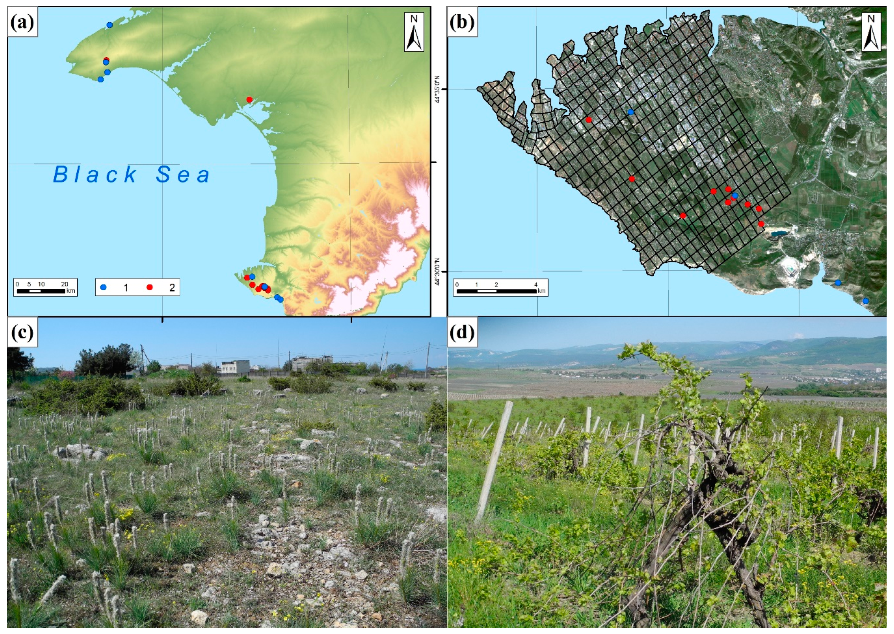
Figure 2.
Exhibition of the Kerch Historical and Archaeological Museum on the ancient agriculture of the Bosporos Kingdom with the capital Pantikapaion (a, courtyard with colonnade 2nd – 1st centuries BC); artifacts of agricultural economy, including amphorae, grape knives (b); various types of press-beds [tarapan] including votive deposit (c) (d). Photographs by Lisetskii F.N.
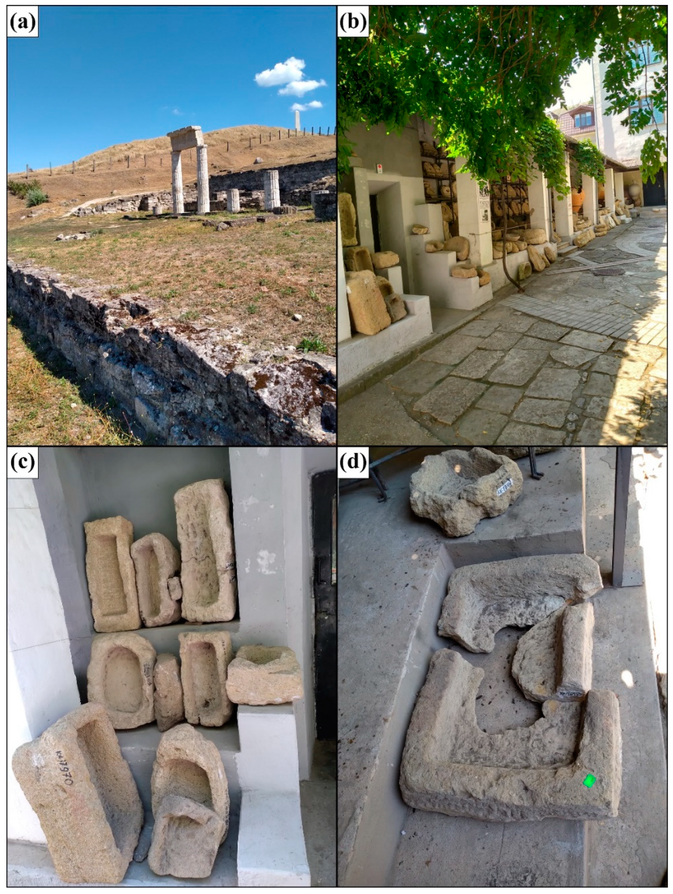
Figure 3.
Results of geomagnetic survey of ancient (4th – 3rd c. BC) land plot for perennial plantings (1.2 km north-east of the town of Kalos Limen (4th c. BC – 2nd c. AD) and results of deciphering the land survey system of 4500 m2 [51] (a); Stratigraphic trench 70 m long across the plantation walls (red arrow) (a, b); Coastal zone in the north of Tarkhankut Peninsula, where ancient vineyard was planted (section 29) and virgin soil was identified (section 30) (c).
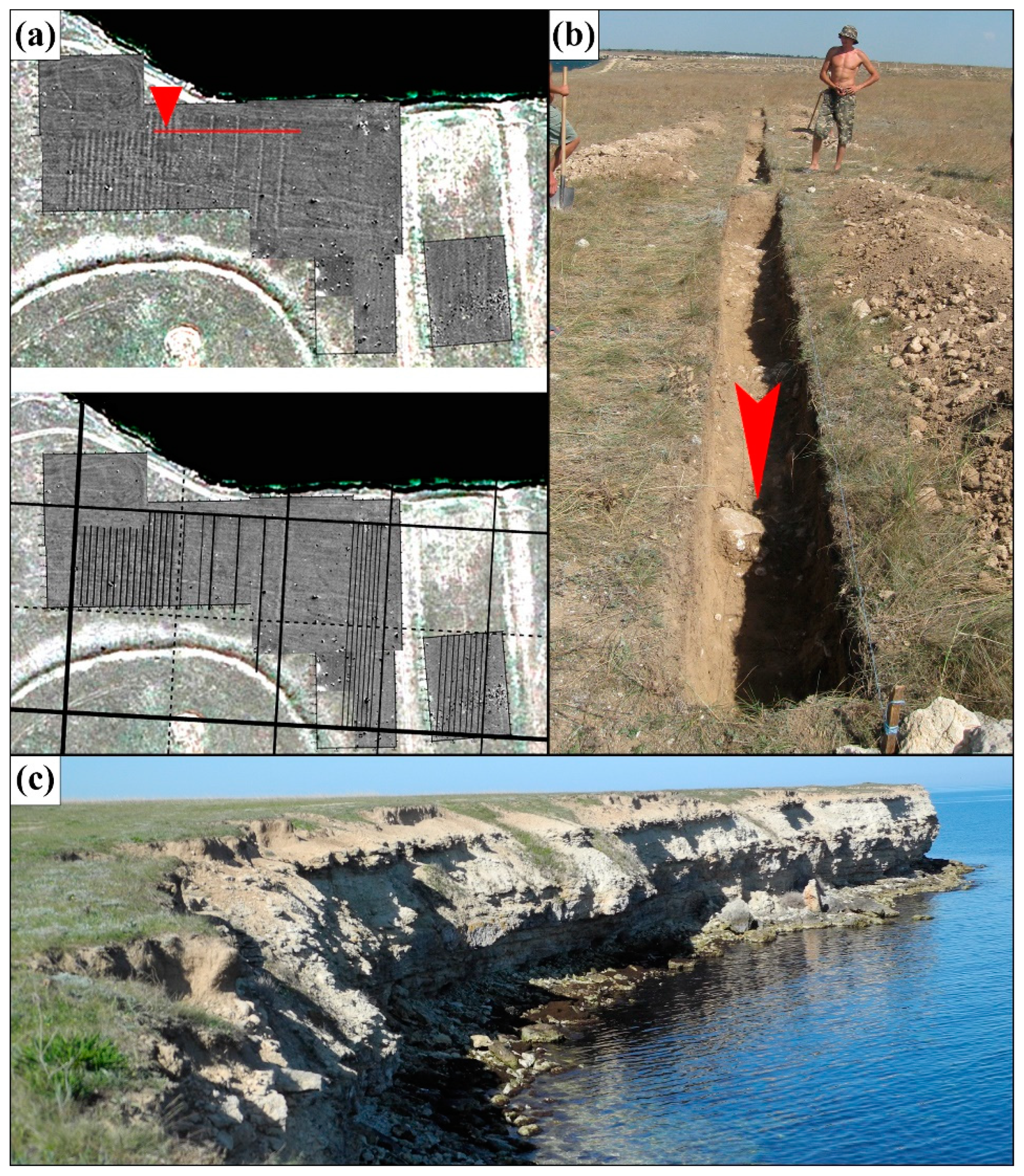
Figure 4.
Results of geomagnetic survey of ancient (4th – 3rd c. BC) land surveying (Chersonesos type) on the area of 77200 m2 for perennial plantings (4th c. BC) and the scheme of interpretation of the land surveying system [56] (a); the best preserved vineyard plot with the width between the plantation walls of 2 m (section 32) (b); Coastal zone in the south of Tarkhankut Peninsula with a cliff height of 6 m, located 160 m to the south of the ancient vineyard with subsoil walls (c, d).
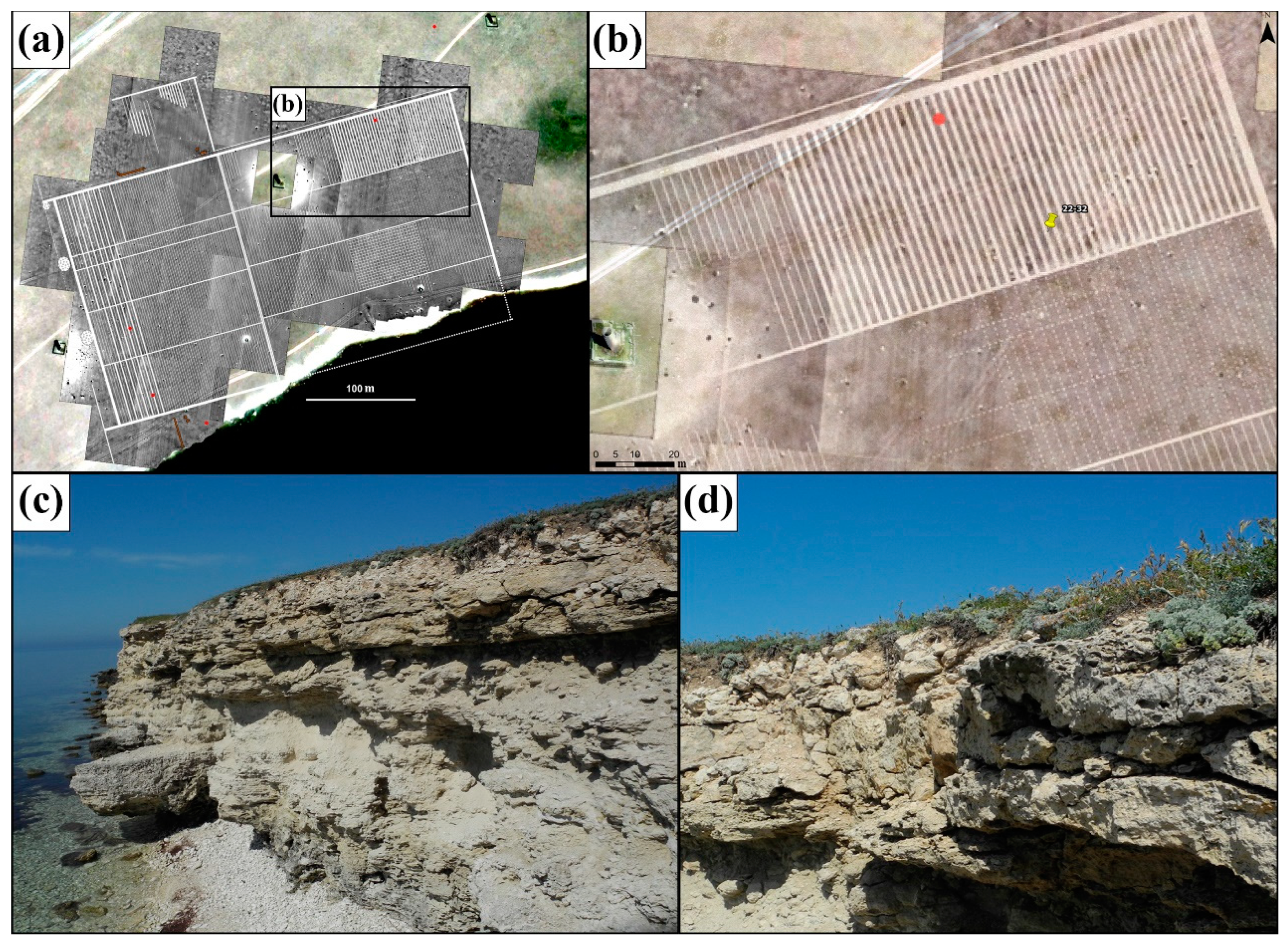
Table 5.
Agrochemical indicators of postagrogenic soils and their zonal analogues.
|
No. section |
CEC | рН H2O | СО2 | P(mob.) | K(mob.) | Cu(mob.) | B(mob.) | Mb(mob.) | SQ(8) |
| cmol+ kg-1 | % | mg/kg | |||||||
| 29 | 24.6 | 8.1 | 16.38 | 6 | 435 | 0.115 | 1.78 | 0.11 | 0.074 |
| 30 | 26.6 | 8.1 | 15.34 | 7 | 785 | 0.116 | 2.56 | 0.13 | 0.079 |
| 31 | 20.8 | 8.2 | 9.77 | 9 | 380 | 0.099 | 2.00 | 0.11 | 0.069 |
| 32 | 24.4 | 8.0 | 16.50 | 5 | 301 | 0.106 | 2.48 | 0.12 | 0.074 |
| 33 | 32.6 | 8.1 | 24.13 | 5 | 242 | 0.092 | 1.67 | 0.13 | 0.062 |
| 34 | 25.2 | 8.2 | 11.26 | 6 | 209 | 0.148 | 1.51 | 0.14 | 0.064 |
| 35 | 29.2 | 8.1 | 4.93 | 8 | 346 | 0.123 | 4.04 | 0.11 | 0.060 |
| 36 | 36.8 | 8.1 | 9.76 | 5 | 401 | 0.115 | 3.07 | 0.12 | 0.063 |
| 37 | 33.4 | 8.1 | 11.46 | 5 | 321 | 2.240 | 2.10 | 0.13 | 0.100 |
Table 6.
Content (%) of useful for plants macro- and microelements in horizon A of postagrogenic soils and virgin analogues (North-West Crimea).
Table 6.
Content (%) of useful for plants macro- and microelements in horizon A of postagrogenic soils and virgin analogues (North-West Crimea).
| No. section |
Ca | Si | Fe | Mg | Mn | K | P | S | Cl | Ni | Cu | Zn | SQ(7) | SQ(12) |
|---|---|---|---|---|---|---|---|---|---|---|---|---|---|---|
| % | mg/kg | |||||||||||||
| 29 | 16.80 | 17.42 | 1.89 | 0.96 | 0.06 | 1.33 | 0.09 | 877.35 | 98.47 | 27.37 | 22.95 | 52.99 | 1.21 | 0.15 |
| 30 | 15.59 | 18.12 | 1.96 | 1.03 | 0.06 | 1.41 | 0.09 | 874.35 | 156.06 | 30.14 | 21.97 | 54.50 | 1.23 | 0.16 |
| 31 | 9.01 | 21.62 | 3.15 | 0.96 | 0.07 | 1.49 | 0.09 | 681.13 | 48.67 | 47.77 | 17.88 | 69.10 | 1.28 | 0.15 |
| 32 | 16.95 | 17.51 | 1.82 | 0.90 | 0.05 | 1.25 | 0.09 | 975.69 | 80.96 | 27.36 | 27.29 | 54.46 | 1.15 | 0.15 |
| 33 | 25.95 | 10.51 | 1.19 | 0.72 | 0.04 | 0.91 | 0.04 | 691.50 | 95.44 | 15.02 | 43.07 | 43.02 | 0.86 | 0.12 |
| 34 | 10.80 | 22.09 | 2.52 | 1.03 | 0.08 | 1.33 | 0.09 | 526.00 | 25.21 | 38.63 | 28.57 | 62.70 | 1.29 | 0.14 |
| 39 | 8.75 | 23.22 | 2.73 | 1.00 | 0.07 | 1.49 | 0.08 | 586.34 | 16.44 | 41.15 | 25.69 | 63.40 | 1.24 | 0.13 |
| 40 | 5.75 | 25.11 | 3.00 | 1.01 | 0.09 | 1.41 | 0.07 | 539.45 | 6.11 | 47.01 | 14.49 | 65.81 | 1.21 | 0.11 |
Table 7.
Content of useful for plants macro- and microelements in horizon A of postagrogenic soils and virgin analogues on the Chersonesean chora.
Table 7.
Content of useful for plants macro- and microelements in horizon A of postagrogenic soils and virgin analogues on the Chersonesean chora.
| No. section |
Land a | No. plotb |
Depth cm |
Munsell colour (dry) |
Ca | Si | Fe | Mg | Mn | K | P | S | Cl | Ni | Cu | Zn | SQ(7) | SQ(12) |
|---|---|---|---|---|---|---|---|---|---|---|---|---|---|---|---|---|---|---|
| % | mg/kg | |||||||||||||||||
| 35 | V (forest) | - | 3.6-19.5 | 10YR 6/4 | 4.60 | 53.90 | 5.30 | 1.70 | 0.06 | 2.60 | 0.10 | 545.50 | 107.30 | 62.00 | 19.70 | 97.30 | 0.15 | 1.05 |
| 43 | V (steppe) | - | 1.5-17 | 10YR 5/5 | 0.60 | 73.40 | 3.50 | 0.90 | 0.04 | 1.20 | 0.10 | 565.90 | 56.00 | 28.30 | 39.30 | 52.20 | 0.09 | 0.59 |
| 36 | PA-F | 153 | 3.5-20.5 | 7.5YR 4/4 | 12.6 | 44.80 | 4.90 | 1.50 | 0.10 | 2.10 | 0.20 | 737.00 | 20.10 | 58.50 | 13.20 | 87.30 | 0.14 | 1.32 |
| 37 | PA-F + VY(MF) | 378 | 4-21 | 7.5YR 4/6 | 15.4 | 43.50 | 4.30 | 1.10 | 0.08 | 1.40 | 0.20 | 654.80 | 65.50 | 43.80 | 306.40 | 90.40 | 0.18 | 1.16 |
| 41 | PA-F | 175 | 0-21 | 7.5YR 5/4 | 20.04 | 37.39 | 3.75 | 1.34 | 0.08 | 1.71 | 0.15 | 805.65 | 32.75 | 44.84 | 28.25 | 75.66 | 0.14 | 1.17 |
| 42 | PA-F | 131 | 0-18 | 10YR 5/4 | 27.04 | 30.28 | 2.96 | 1.38 | 0.08 | 1.65 | 0.16 | 871.73 | 47.96 | 34.38 | 8.25 | 66.59 | 0.13 | 1.16 |
| 44 | PA-F | 360 | 3-17.5 | 10YR 4/3 | 19.62 | 37.72 | 4.14 | 1.21 | 0.07 | 1.46 | 0.16 | 715.20 | 16.14 | 42.83 | 19.09 | 83.21 | 0.13 | 1.13 |
| 45 | PA-F + VY(MF) | 365 | 2-14.5 | 10YR 5/4 | 22.90 | 36.42 | 3.81 | 1.17 | 0.08 | 1.54 | 0.08 | 332.84 | LOD | 36.73 | 56.60 | 72.70 | 0.18 | 1.05 |
| 46 | PA-F + VY(MF) | 366 | 2-17.5 | 10YR 5/3 | 4.53 | 55.29 | 5.40 | 1.27 | 0.15 | 1.79 | 0.12 | 369.79 | LOD | 62.41 | 138.96 | 93.93 | 0.22 | 1.12 |
| 47 | PA-F + VY(MF) | 380 | 1.5-20 | 10YR 4/4 | 7.69 | 53.17 | 4.82 | 1.27 | 0.10 | 1.55 | 0.14 | 461.02 | LOD | 50.66 | 178.74 | 92.30 | 0.23 | 1.12 |
| 48 | PA-F + MF | 379 | 1.5-21 | 7.5YR 4/3 | 2.69 | 59.68 | 5.36 | 1.21 | 0.13 | 1.79 | 0.10 | 349.43 | LOD | 58.95 | 98.69 | 83.12 | 0.20 | 0.99 |
| 49 | PA-F +VY | 403 | 0-21 | 7.5YR 4/2 | 2.15 | 58.76 | 5.39 | 1.49 | 0.11 | 1.68 | 0.13 | 307.77 | LOD | 51.78 | 34.12 | 78.81 | 0.17 | 0.99 |
| 50 | PA-F +VY | 403б | 0-20 | 10YR 5/4 | 16.68 | 46.40 | 3.54 | 1.45 | 0.10 | 1.48 | 0.23 | 374.39 | 5.70 | 25.82 | 98.76 | 68.33 | 0.13 | 1.27 |
| 51 | PA-F + VY(MF) | 404 | 0-21 | 10YR 5/4 | 5.84 | 56.04 | 4.95 | 1.88 | 0.12 | 1.22 | 0.17 | 294.09 | 9.25 | 20.59 | 40.29 | 80.75 | 0.12 | 1.17 |
| 52 | PA-F | 268 | 2.5-19.5 | 10YR 4/3 | 10.60 | 49.11 | 4.63 | 1.55 | 0.10 | 1.96 | 0.21 | 802.02 | 6.09 | 50.24 | 16.65 | 89.47 | 0.13 | 1.29 |
Disclaimer/Publisher’s Note: The statements, opinions and data contained in all publications are solely those of the individual author(s) and contributor(s) and not of MDPI and/or the editor(s). MDPI and/or the editor(s) disclaim responsibility for any injury to people or property resulting from any ideas, methods, instructions or products referred to in the content. |
© 2025 by the authors. Licensee MDPI, Basel, Switzerland. This article is an open access article distributed under the terms and conditions of the Creative Commons Attribution (CC BY) license (http://creativecommons.org/licenses/by/4.0/).
Copyright: This open access article is published under a Creative Commons CC BY 4.0 license, which permit the free download, distribution, and reuse, provided that the author and preprint are cited in any reuse.


