
Submitted:
20 February 2025
Posted:
20 February 2025
You are already at the latest version
Abstract
This paper discusses assessment of the water sources of Western Kazakhstan. It is one of the territories with the lowest water supply in the country, consisting of Aktobe, Atyrau, West Kazakhstan, and Mangystau regions. The distribution of water resources was assessed by administrative units. When assessing renewable water resources of rivers and streams by administrative units, it is necessary to identify a local runoff, inflow from adjacent administrative units, outflow from the assessed administrative unit, as well as the total resources of administrative units. Currently, small-scale maps, satellite and geoinformational images are used for a more accurate identification of the number of water bodies in the region and the lake percentage in certain areas. The impact of anthropogenic activities significantly distorts natural water reserves, the anthropogenic load on river runoff and lake resources has been assessed. A number of maps were built, namely, specific water supply of the population and territory with total resources; lake percentage; load on total resources; and an indicator of water stress of total resources by administrative units. Thus, surface water resources of Western Kazakhstan are fresh water reserves contained in such water bodies as rivers, lakes and reservoirs, amounting to 14600 million m3.
Keywords:
water resources
; water fund
; water availability
; assessment methods
; administrative units
1. Introduction
Water resources are a national treasure in all countries of the world, and water supply is a key indicator of sustainable development of society in social, economic and environmental aspects. In accordance with United Nations General Assembly Resolution No. 70/1 “Transforming our world: the 2030 Agenda for Sustainable Development,” one of the Goals of sustainable development is to ensure the availability and rational use of water resources [1].
The Food and Agriculture Organization of the United Nations emphasizes the great importance of water resources for ensuring food security and nutrition in the world (water is crucial for agriculture, which accounts for up to 72% of global fresh water consumption). Taking into account climate change and population growth, ensuring access to clean water and sustainable management of water resources are becoming important tasks for the global community [2].
Over the past thirty years, fresh water resources have been declining in all regions of the world, and water supply and quality have been decreasing around the world at an alarming rate. These are crucial and worrying trends. The reduction in fresh water resources, climate change, droughts, floods and pollution of water sources (increasing load on water resources of our planet) are serious challenges for the sustainable use of water and meeting the needs of the mankind. The world's water resources face an unprecedented load as a result of population growth and economic development. Estimates show that in present-day conditions, a water shortage of 40% is expected in the world by 2030, if we compare the predicted demand and available water resources [3].
Climate change exacerbates the situation by increasing the unpredictability of water availability, as well as the frequency and intensity of floods and droughts. In the conditions of increasing water scarcity, determining who can use water resources, for what purposes, in what amount and in what capacity, where and when, in other words, determining the distribution of water resources is a serious problem [4–15]. This is particularly true for Western Kazakhstan, which is one of the regions with the lowest water supply that depends on the inflow from Russia.
Rich natural resources, advantageous location, and a developing economy that has ties to many cities in Russia and other countries create favorable conditions for the successful development of the region’s foreign economic activity. Western Kazakhstan includes West Kazakhstan, Atyrau, Mangystau, and Aktobe regions. Its vast territory extends 1200 km from north to south and 1300 km from west to east. Oil production has been carried out in the region for more than 100 years. Atyrau is the center of black caviar production and canning.
The geographical location of Western Kazakhstan characterized by arid climate explains the fresh water shortage and the predominance of deserts and semi-deserts in most of its territory. Western Kazakhstan is mostly a desert or steppe region, with many of its rivers and lakes drying up regularly. This makes the Zhaiyq (Ural) River, which is considered to be the border between Europe and Asia here, the main waterway of the region; it is the only non-seasonal river that runs from north to south through the western part of the region all year round. These factors complicate the development of agriculture, especially crop farming, as well as the work of industrial enterprises.
Western Kazakhstan has been and remains the region with the most severe natural and climatic conditions in the republic. These problems have become especially acute over the past decades of intensive development of the region by oil and gas companies and military organizations. Of all the riverine zones, only the basin of the Zhaiyq River, the largest one here, remains suitable for a more or less normal life. Zhem, Oiyl and Temir, which have earlier been life-giving, water-abundant and ecologically safe rivers, are drying up. The largest lakes are Inder, Aralsor, and Kamys-Samar Lakes. The Caspian Sea plays an important role in the region. As a result, 90-95% of the territory of Western Kazakhstan is characterized by a painful struggle for survival: people strive to last at any cost until they get the opportunity to move to one of the major administrative or industrial centers. Earlier, all these lands were used for the needs of the agricultural sector of the region.
In this regard, assessing the state of water resources in the territory of the Western region is an urgent issue in terms of water supply of the population amid the changing climate and anthropogenic impact.
The oil and gas boom, expressed in the influx of foreign investment and the steady growth of production figures, is observed in all four regions of Western Kazakhstan. This development is also based on water supply, like any other industrial production.
2. Materials and Methods
2.1. Study Area
Western Kazakhstan is an economic and geographical region in the north-west of the Republic of Kazakhstan, located in Eastern Europe and Central Asia in the area of 41o10/-51o45/ north latitude and 46o20/-64o0/ east longitude. Western Kazakhstan consists of 4 regions (Atyrau, West Kazakhstan, Aktobe and Mangystau) and 32 administrative units. It is bordered in the north by the Russian Federation and in the south by the republics of Uzbekistan and Turkmenistan. In the west it is washed by the Caspian Sea, and in the east it is bordered by Ulytau, Kostanay, and Kyzylorda regions of the Republic of Kazakhstan. The territory in question extends from the eastern edge of the delta of the Volga River in the west to the Turan lowland in the southeast, from the southern spurs of the Urals and the Obshchy Syrt in the north to the Ustyurt plateau and Turkmen deserts in the south. The total area of the territory is 736,241 km2, extending 1,200 km from north to south, and 1,300 km from west to east (Figure 1). Western Kazakhstan is the largest economic and geographical region of the country in terms of the occupied area, and one of the most important regions for the economy of the Republic of Kazakhstan. The key sectors of its economy are the development of oil and gas fields, agriculture, and fishery [16].
The peculiarities of the terrain, the vegetation and topsoil, and the climate are the reason for the specific conditions of the river system distribution. The river system distribution in West Kazakhstan, Atyrau and Mangystau regions is due to the presence of the Caspian Sea in the southwest and the mountain structures of the Southern Urals in the northeast, so the general flow direction of rivers here is from northeast to southwest. In Mangystau Region, the hydrographic network is developed very poorly and is characterized by a more uneven distribution. Closed drainage basins are widespread here, surrounded by a large number of dry beds, river arms and gullies, where surface runoff is carried out only in spring and autumn. The river system distribution in Aktobe Region is due to the meridional location of the main watershed of the Mugalzhar Range and the aridity of the climate in most of its territory.
The region in question has over 1500 rivers and temporary streams with a length of more than 10 km, the total length of which exceeds 45000 km; more than 10 rivers have a length of more than 200 km. The main surface water sources of the region are the northeastern and eastern shores of the Caspian Sea, the rivers Zhaiyq, Oiyl, Zhem, Sagyz, Torgay, Yrgyz, Elek, Or, Kobda, Shagan, Karaozen and Saryozen, the delta branches of the Volga, such as Kigach and Sharanovka, and other small rivers. There are 325 lakes of various origins in Western Kazakhstan with water surface areas of 1 and more km2. Lakes are located unevenly. They are either hundreds of kilometers far from each other or are located so densely that they form lake areas (the basin of the Torgay River within Aktobe Region) [17-22].
2.2. Methods
In terms of economy, it is very difficult to divide surface water resources between districts and plan various activities based on their specific volumes, on which planning in other districts depends at the same time. However, there are certain industry tasks within which these issues have to be addressed. Practical requirements can be met with an integrated approach, using sufficiently reliable materials and the correct methodology and calculation scheme.
The main difficulty in assessing surface waters by administrative units is that the boundaries of administrative units do not correspond to the natural boundaries of river basins. It is especially difficult to do it for territories located in arid zones, where a basin of one relatively small river can occupy the territory of several administrative units.
When assessing renewable water resources of rivers and streams by administrative units, the following characteristics should be considered:
– determining the local runoff (assessment of the runoff of the explored areas based on data from stream gauges; determining the runoff from unexplored areas of an administrative unit using a runoff isoline map or regional curves h=f(F), with further weighing relative to the entire area of an administrative unit or any part of it; the ration of the explored and unexplored areas of the territory; assessment of the runoff from the unexplored area of an administrative unit by analogy with the explored one);
– determining the inflow of water from adjacent territories (determining the inflow with the use of data from stream gauges at rivers flowing into a given area located near the borders of administrative units; bringing the values of the runoff of the river in question to the border of the studied administrative unit by interpolating the normal runoff with respect to the river length);
– determining the outflow of water outside this administrative unit (by analogy with an inflow, taking into account the runoff values of stream gauges located at effluent rivers);
– determining the transit runoff, which includes waters that flow through the territory of a certain administrative unit, except for the part that is lost due to natural losses;
– determining the inflow of water from abroad and outflow from the country based on data on the river runoff from the river stations located near the state borders;
– determining the total resources of administrative units by summing up local runoff and inflow from adjacent districts.
Currently, small-scale maps, as well as satellite and geoinformation images are used to determine the number of reservoirs in the region and the lake percentage in specific areas (regions and administrative units) more precisely. The ArcGIS 10.5 software package was used to work with spatial data. Vector layers of the hydrological network of the region were used as the basis for creating a geodata database of the lakes of Western Kazakhstan. To determine the area from 0.95 km2 and the number of natural reservoirs, raster topographic maps with a scale of 1:100000 were used, which were vectorized during the work. Later, the area of the lakes was refined by decoding satellite images of the earth’s surface with multispectral (6 ranges) 30-meter resolution imaging made by the ETM+ camera of the Landsat7 satellite of the United States Geological Survey (USGS) in 1984-2020. Based on the data obtained, the relevant electronic layers of maps were compiled, and an analysis of the distribution of lakes across the administrative units of the region was conducted [20].
Climate change has a significant and diverse impact on water resources. There is growing evidence that climate changes occurred over the past decades have already affected the global hydrological cycle, for example, by changing seasonal river runoff [23]. Anthropogenic activities, including economic ones, lead to greater consequences of climate change. The latter poses an additional danger to the regime of runoff, which plays an important role in maintaining the activity of aquatic ecosystems. According to the Eighth National Communication, by the end of the XXI century, a temperature increase more significant than the global average and the value for most other Asian countries is predicted in Kazakhstan [24].
The dynamics of surface water resources over time contributes to fluctuations in the specific natural water supply and is of particular importance for making schemes of the development of productive forces in any territory, as well as for the use of water resources and their protection from depletion and pollution. The natural specific water supply in high and low flow years may vary for different territories.
The use of water for various economic needs is the main anthropogenic factor affecting the surface water resources of large river systems and regions. Therefore, in order to assess the state of water resources in any region, we should first get data on water consumption in this region and its dynamics over a long period. In turn, the volume and structure of water consumption in the region are determined by its social and economic development, population size, as well as physical and geographical conditions. With data on water consumption, it becomes possible to characterize the state of water resources, which is determined by comparing water resources available in a given region with the volume of water used, as well as the population size [25].
For this purpose, various criteria and indicators are usually used (water stress index, water supply per capita, dependency ratio). To assess water supply in various regions and countries, an approach based on the use of the load on water resources (utilization ratio) applies, which is a percentage ratio of total water consumption to renewable water resources. Renewable water resources are the total of local water resources formed within the region in question plus the inflow of river waters from adjacent territories. This approach to assessing water supply has been applied in the works of various researchers [26–29]. In the proposed approach, the degree of load on water resources is determined according to the classification that includes five categories [25,30–33].
The paper by Shiklomanov [25] considers it more reasonable to estimate the real load on water resources by taking the minimum annual average value of water resources over three consecutive low water years of observations. Data for low water periods are, of course, significantly lower than the average annual values, especially if there is high variability of long-term fluctuations in water resources. These values, condtionally named as real water resources, together with the long-term average annual values are used to assess the load on surface water resources.
In any case, this approach, based on an assessment of the degree of load on surface water resources, does not fully characterize the shortage of water resources in a particular region, since it does not take into account its population size. To account for this factor, it is proposed to use the indicator of specific water supply, calculated as the ratio of real water resources less consumptive water use to the population size [25].
The state of surface water resources in the region is estimated by the values of water supply, which is understood as the amount of water per capita. In this context, two types of water supply, namely, potential and actual water supply, should be distinguished. Potential water supply is the ratio of long-term average annual renewable water resources to the population size. The value of potential water supply gives an idea of the general state of water resources in the country in the natural conditions of their formation, and allows giving a comparative characteristic of individual regions and analyzing the dynamics of water supply over a certain period.
However, the use of potential water supply in estimates, especially for regions with limited water resources, leads to a distortion of the objective situation, since potential natural water supply is always overestimated compared to the reality. This is due to the fact that part of the water is not taken into account, which is lost permanently when being used. Besides, in some years and periods, water resources are much less than the long-term average annual values. To account for these circumstances, for all administrative units that may face water scarcity in low water years, actual water supply is analyzed together with the assessment of the load on water resources. The value of actual water supply is the residual (after use) amount of water per capita in low water years.
The load on water resources and water supply are determined relative to the total long-term average annual water resources, which makes it possible to assess the necessary measures to regulate or redistribute river runoff, as well as eliminate existing or potential water shortages. According to the other point of view mentioned in papers [34-37], the utilization ratio is calculated as the ratio of water intake for household needs to the minimum water content of rivers in the limiting winter period. This approach to calculating the water utilization ratio has fundamental advantages and limitations. The advantages include taking into account the minimum need for water necessary to maintain biological diversity and the ecological state of aquatic ecosystems. The limitations are its one-sided approach that does not take into account many factors that affect water demand (for example, changes in land use).
The paper by Shiklomanov [37] proposes an alternative option, according to which the calculation of specific water supply is based on the sum of the amount of local water resources and half of the inflow of fresh water coming from adjacent territories. Later, this approach became widespread for both regional and global assessments [38-42].
Due to the significant water intake for household needs, the values of potential and actual specific water supply are often specified; when calculating the latter, non-renewable withdrawals of part of the river runoff are taken into account. As already noted, lake resources are an important type of fresh water resources, and their use grows with an increase in anthropogenic activity. In this regard, to carry out modern assessment of water supply, it would be of interest to consider water supply of the Western region not only from renewable resources, but also from water resources contained in natural and artificial reservoirs. Here, the data on water supply of the population from natural water resources should be comparable with the results of the assessment of water supply with renewable water resources.
One of the most common approaches in European practice is the Falkenmark criterion. According to the Falkenmark indicator, a specific supply of less than 1700 m3/year shows water tension [43,44]. However, this criterion reflects only water reserves, but does not take into account the need for water resources, assuming that demand is uniquely determined by the population of the region in question [45]. An alternative approach is used to calculate the sustainability index, which is the ratio of the volume taken from water sources to the total replenished volume of water [32]. When the sustainability index is used, we speak of water shortage if water consumption exceeds 20% of renewable runoff, and of acute water shortage if this indicator exceeds 40% [46].
Thus, four approaches to the problem of water scarcity are used with appropriate indicators of scarcity:
– Falkenmark index (IF), also known as the water stress index;
– criticality ratio (CR), also known as the UN indicator;
– index of the International Water Management Institute (IWMI);
– water poverty index (WPI).
Of these four indexes, IF is the most widely used one, mainly due to its simplicity and clarity. The use of the IF index makes it possible to assess the level of water consumption in a particular country based on a number of threshold values.
The CR index approach is similar to the IF approach, as it also evaluates the ratio of water intake from all available sources to all available water resources. According to it, the country is experiencing a water shortage if the annual intake is from 20 to 40% of the annual water supply (renewable fresh water), and a severe shortage if this figure exceeds 40%. However, both approaches have disadvantages: they do not take into account the country’s technical and social ability to adapt to water shortages, the fact that not all available water is drinkable due to its pollution, and other factors.
The IWMI approach is more flexible and takes into account a number of economic and infrastructural factors characterizing water consumption. This index shows that insufficient water supply may depend not only on water scarcity in its physical sense, but also on poorly organized water supply infrastructure. For example, for the Democratic Republic of the Congo, which has rich water resources, this approach shows that its inherent water shortage is a “second-order deficit,” since it is primarily caused by the lack of funds necessary to supply water to consumers.
Meanwhile, this approach is not perfect too, since it does not take into account the “third-order deficit,” when water scarcity is due to the lack of developed management institutions, and the “fourth-order deficit,” when water scarcity is due to social relations and political processes.
The WPI index takes into account a number of factors that go unnoticed in approaches that use other indices, including the potential of water management, water quality, the nature of needs met by water supply, etc. However, due to its comprehensive nature, it turns out to be too difficult for interpretation.
All the above indices provide information about water consumption in a very generalized form – they allow analyzing the situation at a national and even regional level, but still overlook many important details. At the same time, the approaches associated with their use should hardly be considered adequate in political terms. Thus, the approach based on the use of the IF index, in fact, involves the development of a policy to limit the population size, since water scarcity in this approach is directly associated with population growth [47].
The combination of indices of all parameters can provide a general index of water security. An important difference is whether the water security assessment will be used for comparison and comparative analysis (for example, comparing water security of countries, cities and river basins), or for decision-making (for example, to determine the preferable investment strategy for improving water security in a particular case). Therefore, the above criteria are necessary for assessing supply of administrative units with surface waters.
3. Results and Discussion
3.1. Assessment the Conditionally Natural Resources of Surface Waters by Administrative Units
Water resources of administrative units consist of a combination of local runoff (formed within a given territory), inflow (from outside a given territory), and outflow (from a given territory). The concept of transit runoff is also used, which includes waters running through the territory of a certain administrative unit, except for the part lost due to natural losses. However, the resources of the Zhaiyq River that runs directly through the territory of administrative units have been included in the total inflow and outflow to/from these administrative units. Here, there is uncertainty about the passage of the border line and the problem of attributing the resources of these rivers to certain administrative units. In order to avoid double counting, river resources have been considered separately at the points of entering and leaving these administrative units.
The river runoff resources of Western Kazakhstan amount to 11360 million m3, of which the local runoff resources in the territory of Kazakhstan are 3785 million m3, and the inflow from the Russian Federation is 8595 million m3, while the outflow to the Russian Federation is 1037 million m3. The region is 70% dependent on the inflow from Russia through the Ural River and its tributaries, Karaozen and Saryozen [Certificate, 2024]. The assessment of supply with surface water resources has been carried out using the indicators of supply of the population and the territory with locally formed and total resources, taking into account the transboundary inflow from Russia (Figure 2).
The assessment of water supply shows that the Taskala district of West Kazakhstan Region is the most water-rich area in terms of supply of the population with local resources, and the most problematic areas are the districts of Mangystau and Atyrau regions, as well as Akzhaik district of West Kazakhstan Region, which is due to the insignificant formation of local resources. As for supply of the population with total resources, the picture differs significantly, since the most water-rich districts are the districts where the Zhaiyq River runs, such as Akzhaik, Shyngyrlau, and Inder districts.
When analyzing water supply of a territory with local resources formed in Kazakhstan, the most water-rich districts are the districts located in the runoff formation zone.
In general, the most problematic districts in terms of water resources are the districts of Mangystau and Atyrau regions, where almost no water resources are formed. To provide water resources from the Kigash, the arm of the Volga River, through the Astrakhan-Mangyshlak main water pipeline, water is supplied to Kurmangazy, Isatay and Zhylyoi districts of Atyrau Region, as well as to the districts of Mangystau Region.
In addition to river runoff resources, our study has been the first to identify watersheds of 39 lakes with an area of more than 10 km2 using the Google Earth Pro software. The minimum, average and maximum lake watershed altitudes have also been determined using topographic maps and Google Earth Pro software.
323 lakes of Western Kazakhstan with an area of over 0.95 km2 have been grouped by administrative units (region, districts); morphometric characteristics have been calculated for 41 lakes with an area of more than 10 km2 [20].
According to our calculations, there are 323 lakes in Western Kazakhstan with a total area of 1944 km2. The region is characterized by an extremely uneven distribution of lakes, which is due to a complex history of development and a great variety of landscapes. West Kazakhstan Region is characterized by the highest lake percentage (0.42%), which is especially high in Terekti (2.47%) and Bokey Orda (0.84%) districts. It is followed by Aktobe Region (0.34%). Here, the lake percentage of some districts (Yrgyz) reaches 1.27%. The number of lakes in Atyrau and Mangystau regions is significantly fewer. The lake percentage of Atyrau Region is 0.17% with the highest value for Inder district (1.24%) due to a large Lake Inder, while the lake percentage of Mangystau Region does not exceed 0.033% [20].
The surface water resources of Western Kazakhstan consist of the local water resources from river runoff and the volume of water in lakes - 6588 million m3, as well as the transboundary inflow of 8317 million m3. Thus, the total available surface water resources of Western Kazakhstan amounts to 14163 million m3, of which 1037 million m3 is the outflow through the Or, Elek, Kobda and Talovka rivers.
3.2. Assessment of Anthropogenic Load on Surface Water Resources by Administrative Units
The surface water resources of Western Kazakhstan are widely used in various economic sectors. Large reservoirs and many small ponds have been created on some rivers, which leads to changes in the characteristics of the hydrological regime of water bodies.
Quantitative assessment of the use of water resources by economic sectors in the studied region has been carried out on the basis of analyzing data of the 2-TP statistical form of departmental statistical observation (water management) and annual reports of the Zhaiyq-Caspian and Tobyl-Torgay basin inspectorates. 75-97% of water supply of economic sectors in Aktobe, Atyrau and West Kazakhstan regions is provided by surface waters and the rest part - by groundwater, while in Mangystau Region, over 90% of water supply is ensured by sea water.
In this paper, the assessment of the load on the river runoff resources of Western Kazakhstan has been carried out for annually renewable local natural resources and total water resources, taking into account the actual inflow in administrative units.
As for the long-term average values of local water resources, the greatest load (category V - critically high load) on water resources) was noticed in Atyrau Region, where the volume of local formation amount to only 34 million m3. West Kazakhstan has category III (high load on water resources), while Aktobe and Mangystau regions have category II (moderate load on water resources). In general, Western Kazakhstan belongs to category III (high load on water resources).
As for the long-term average values of total water resources of the area in question, all regions except Mangystau Region, as well as Western Kazakhstan in general are characterized by low load (category I).
According to the schematic maps (Figure 3 and Figure 4), in terms of the long-term average values of local runoff, almost all administrative units of Aktobe Region, except for Aktobe, Kargaly, Oiyl and Yrgyz districts, and except for Kaztal, Zhangaly and Karatobe districts of West Kazakhstan Region, are characterized by low load on the river runoff resources. In the districts of Atyrau Region, the situation is completely different and is characterized by a critically high load on the river runoff resources caused by the low formation of local resources. In Mangystau Region, the main source of water supply is sea water. As for the load on total river runoff resources, the load on water resources in all districts of Western Kazakhstan is not higher.
Due to the natural dynamics of humidity and the growth of water consumption, transformations of the lake fund as a whole or individual lakes and their groups are noticed. The transformations of fresh lakes into the regularly, constantly, slightly and then highly saline ones are observed, which leads to regular drying up of lakes or their complete disappearance. A difficult problem of preserving the lake fund in connection with economic activity appears.
According to archival materials, there had been 420 lakes with an area of over 1 km2, while in 2022, there were 323 lakes, that is, the number of lakes decreased by 23%.
74 of 323 lakes in the region, that is, 23% of the total number, are regulated by reservoirs in the watershed, as well as by pits in the lake beds and canals either for replenishment or for withdrawal of water from lakes.
According to the archival materials of the Institute of Geography and Water Security JSC, in the period from the 1930s to 1965, there were 420 lakes with an area of more than 1 km2 in the region, and the results of space surveys conducted from 1984 to 2022 showed that only 323 lakes with an area of more than 1 km2 remained. The largest decrease in the number of lakes occurred in Atyrau and Mangystau regions (37 lakes out of 109 remained). A significant shrinkage of lake areas is observed. Lakes of Atyrau and Mangystau regions suffered a significant shrinkage from 614.4 to 257.4 km2. In West Kazakhstan Region, the total area of lakes decreased from 728.2 km2 to 653 km2.
Such a decrease is directly related to economic activity in basins, when lakes degradation is caused by withdrawal of water for household needs from water sources. Only Aktobe Region did not face changes in lake percentage, while a significant decrease occurred in Atyrau and Mangystau regions (from 0.22 to 0.09%). In total, the lake percentage of the region decreased from 0.32% to 0.26%.
Water supply of the territory of Western Kazakhstan has been studied both in terms of renewable resources and in terms of water resources contained in natural and artificial reservoirs (Figure 5).
3.3. To Assess the Current State of Surface Water Resources Taking Into Account Climate Change and Anthropogenic Impact by Administrative Units
A large number of canals, reservoirs and other waterworks have significantly changed the annual and long-term hydrological regime of rivers in the region. One of the main factors in terms of the impact on the quantitative characteristics of river runoff is water intake from water sources or water consumption.
The estimated values of load on water resources, as well as their combined analysis using the data on water use allow analyzing the state of water use in each water management area. Based on statistical data on water intake from the form 2-ТP (Water management) and the reports of Zhayiq-Caspian and Tobyl-Torgay basin inspectorates, we have obtained water use values by economic sectors and calculated consumptive water use for them for each administrative unit. Thus, the river runoff of Western Kazakhstan has decreased by 670 million m3 due to consumptive water use only.
Currently, available river runoff resources of Western Kazakhstan amount to 10.7 km3, including the natural local resources of 3.12 km3, the actual inflow from the Russian Federation of 8.32 km3, and the outflow to the territory of the Russian Federation through the Or, Elek and Kobda rivers of 1.02 km3.
The assessment of water supply (Figure 6) shows that Taskala district of West Kazakhstan Region, as well as Kargaly and Kobda districts of Aktobe Region are the most water-rich areas in terms of water supply to the population from actual local river runoff resources, while the most problematic regions are the districts of Mangystau and Atyrau regions, as well as Akzhaik district of West Kazakhstan Region, which is caused by the low formation of local resources. In terms of supply of the population with total resources, the situation is completely different: the most water-rich districts are those where the Zhayiq River runs, such as Akzhaik and Shyngyrlau districts of West Kazakhstan Region and Inder district of Atyrau Region; the most water–poor districts are the districts of Mangystau Region.
According to the assessment conducted for Aktobe Region, 210 natural reservoirs have been identified on satellite images, of which 183 lakes have an area from 0.95 km2 to 10 km2, and 27 lakes have an area of over 10 km2. The lakes are located unevenly. Most of them are located in the eastern part, east of the 58th parallel - a total of 149 lakes, 128 of which have an area from 0.95 to 10 km2., and 21 lakes have an area of over 10 km2. The lake percentage of the territory is small. There is 0.34 km2. of water surface per 100 km2 (including large reservoirs with an area of 0.36 km2).
According to our data, the area of lake coverage of Aktobe Region is about 1035 km2, and the volume of water contained in them is 1073.21 million m3. More than 197.3 million m3 are bitter. The volume of fresh water amounted to 47.8 million m3, brackish lakes - 221.1 million m3, and saline lakes - 607.1 million m3. Thanks to the construction of artificial reservoirs (without ponds), the water surface area in Aktobe Region increased by more than 60 km2, and the volume of fresh water contained in them increased by more than 490 million m3.
According to the assessment conducted for West Kazakhstan Region, 75 natural reservoirs have been identified in satellite images, of which 68 lakes have an area from 0.95 km2 to 10 km2, 7 lakes have an area of over 10 km2, and 2 lakes have an area of over 100 km2. The lake percentage of the region is small and amounts to 0.43% per 100 km2, and taking into account reservoirs, it increases to 0.51% per 100 km2.
The results of the assessments show that the total area of lake coverage in the administrative units of West Kazakhstan Region is about 620.4 km2. The volume of water contained in lakes is about 1535 million m3. Saline lakes with 1111.4 million m3 of water prevail, followed by bitter lakes with water volumes of 253.5 million m3 and brackish lakes with volumes of slightly more than 170 million m3. Due to the construction of artificial reservoirs (without ponds), the water surface area in West Kazakhstan Region increased by more than 118.2 km2, and the volume of fresh water contained in them increased by more than 565.4 million m3.
According to the assessment conducted for Atyrau Region, 32 natural reservoirs have been identified in satellite images, of which 30 lakes have an area from 0.95 km2 to 10 km2. 1 lake has an area of over 10 km2, and 1 lake has an area of over 100 km2. According to our data, the area of water coverage of Atyrau Region by lakes with a water-surface area of over 0,95 km2 is slightly more than 202 km2, and the volume of water contained in them is 156.54 million m3. Of more than 121.73 million m3, bitter lakes have a volume of 47.8 million m3, brackish lakes - 21.71 million m3, and saline lakes - 13.1 million m3. There are no freshwater lakes.
According to the assessment conducted for Mangystau Region, 5 natural reservoirs have been identified in satellite images, of which 2 lakes have an area from 0.95 km2 to 10 km2, and 2 lakes have an area of over 10 km2. The lakes are located hundreds of kilometers far from each other.
Mangystau Region is poor in terms of renewable water resources and is considered one of the most water-poor regions of the country. There are no open water bodies in the region suitable for use in various farms, and it is also remote from large rivers. Even drinking water supply is provided: 1) by using desalination plants of the Republican State Enterprise “Mangystau Nuclear Power Engineering Plant,” which produces drinking water by desalting Caspian water; 2) by using the Volga water supplied by the Astrakhan-Mangyshlak water pipeline; 3) from underground sources.
According to our data, the area of lake coverage of Mangystau Region is about 54.4 km2. The volume of water contained in the lakes is only 38.1 million m3; according to their mineral composition, they belong to bitter lakes. There are no artificial reservoirs in the region.
Current state of surface water resources, taking into account climate change and anthropogenic impact. Surface water resources of Western Kazakhstan are fresh water reserves in water bodies - rivers, lakes and reservoirs - which amount to 14600 million m3. As for the supply of the region in question with local surface water resources, the most water-rich area is Terekti district of West Kazakhstan Region, which is due to the presence of lakes and reservoirs on its territory, and the most water-poor areas are southern districts of West Kazakhstan and Aktobe regions, as well as all districts of Atyrau and Mangystau regions, which have low local surface resources. As for the supply with total surface water resources, the most water-rich areas are the districts where the Zhayiq River runs, such as Akzhaik, Shyngyrlau, and Inder districts.
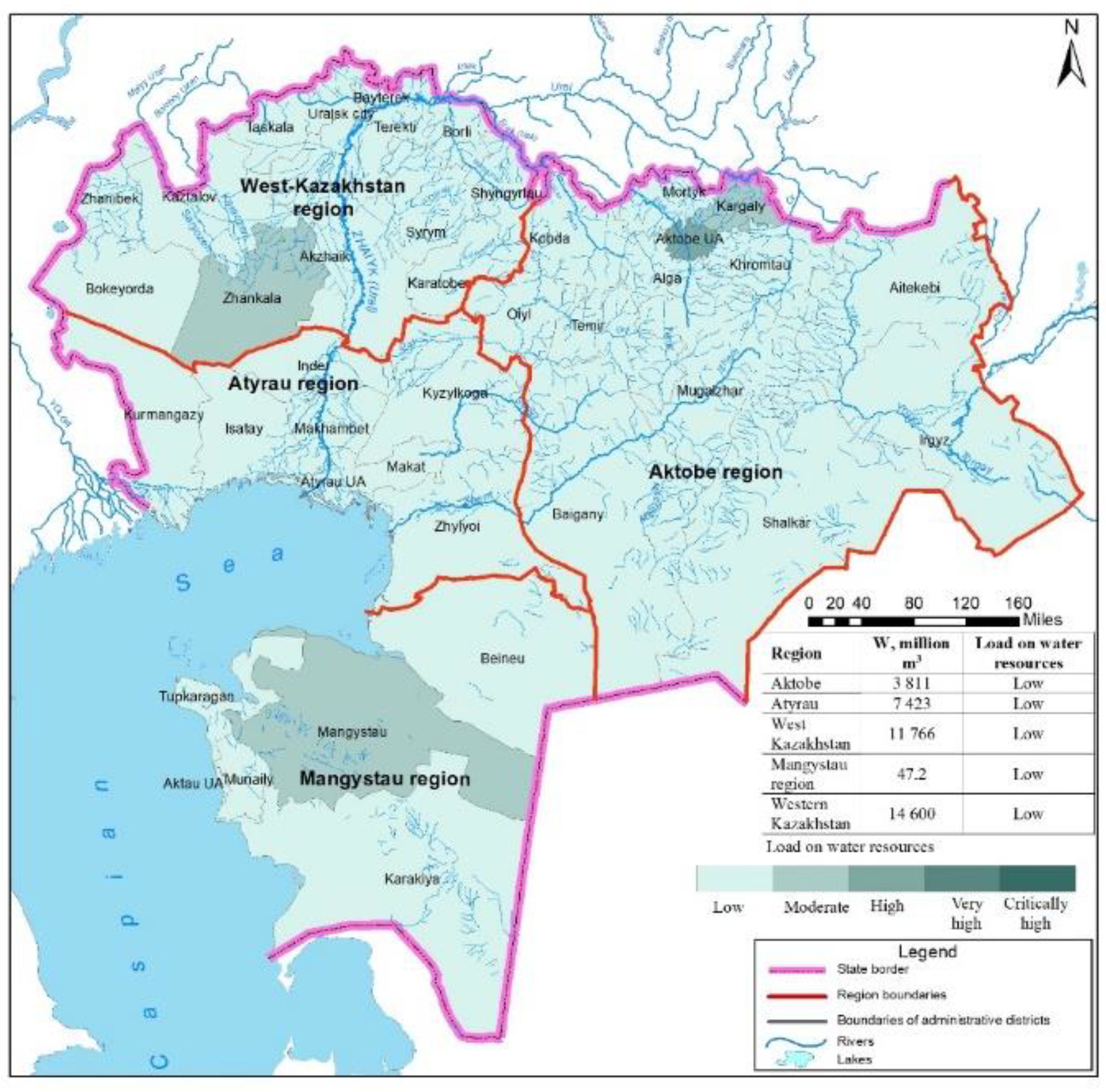
Due to the increase in the intake of surface waters from water sources, the anthropogenic load on water resources is increasing. The highest, i.e., critically high load on local surface water resources is observed in the Akzhaik district of West Kazakhstan Region and in all districts of Atyrau Region, while the lowest load is observed in almost all districts of Aktobe Region except for the city of Aktobe, as well as Oiyl and Kargaly districts. As for the total surface water resources, the load level decreases due to the inflow from adjacent areas (Figure 7 and Figure 8).
5. Conclusions
Western Kazakhstan is 70 % dependent on the inflow from Russia through the Ural River and its tributaries, Karaozen and Saryozen. The total water resources of the river runoff of the entire Western Kazakhstan amount to 11360 million m3, 3785 million m3 of which are local resources.
323 lakes of Western Kazakhstan with an area of over 0.95 km2 were grouped by administrative units (region, districts). Morphometric characteristics were calculated for 41 lakes with an area of more than 10 km2. According to the archival materials of the Institute of Geography and Water Security JSC, in the period from the 1930s to 1965, there were 420 lakes with an area of more than 1 km2 in the region, and the results of space surveys conducted from 1984 to 2022 showed that only 323 lakes with an area of more than 1 km2 remained. The total volume of water in lakes was as follows: Aktobe Region – 1073,21 million m3, Atyrau Region – 156,54 million m3, West Kazakhstan Region – 1535 million m3, and Mangystau Region – 38,1 million m3. Total for Western Kazakhstan: 2803,45 million m3.
The surface water resources of Western Kazakhstan are fresh water reserves in water bodies - rivers, lakes and reservoirs, which amount to 14,600 million m3.
Recommendations for the rational management of water resources in Western Kazakhstan:
1) It is necessary to strengthen the role of scientific research in the basins of the transboundary Karaozen and Saryozen rivers to provide science-based water apportioning between Russia and Kazakhstan.
2) To assess the current technical state and characteristics of hydraulic structures in the river basins of Western Kazakhstan in order to find possible ways of creating new reservoirs or other ways of induced recharge during floods.
3) To study annual changes in river runoff over several years in order to assess susceptibility of the studied territory of Western Kazakhstan to dangerous hydroclimatic phenomena such as droughts and floods.
This section is not mandatory but can be added to the manuscript if the discussion is unusually long or complex.
6. Patents
As a result of the work presented in this manuscript, a copyright certificate was obtained for the maps of water supply of the West Kazakhstan region by administrative districts (Certificate of Entry into the State Register of Rights to Copyrighted Objects No. 50863 dated October 29, 2024).
Author Contributions
Conceptualization, A.T. and S.A.; methodology, A.S and K.K.; software, A.B.; formal analysis, A.S and K.K.; investigation, A.S and K.K.; resources, A.T. and S.A.; data curation, A.T., S.A. and K.K.; writing— A.T., A.S., A.B. and K.K.; writing—review and editing, A.S. and A.T.; visualization, A.S. and A.B.; supervision, A.T.; project administration, A.S. All authors have read and agreed to the published version of the manuscript.
Funding
This research was funded by the Committee of Science of the Ministry of Science and Higher Education of the Republic of Kazakhstan (Grant No. BR21882122) «SUSTAINABLE DEVELOPMENT OF NATURAL-INDUSTRIAL AND SOCIO-ECONOMIC SYSTEMS OF THE WEST KAZAKHSTAN REGION IN THE CONTEXT OF GREEN GROWTH: A COMPREHENSIVE ANALYSIS, CONCEPT, FORECAST ESTIMATES AND SCENARIOS».
Data Availability Statement
The data will be available on request from the first author.
Conflicts of Interest
The authors declare no conflicts of interest.
References
- The Sustainable Development Agenda. UN. Available online: https://www.un.org/sustainabledevelopment/ru/about/development-agenda/ (accessed 2 October 2023).
- Food and Agriculture Organization of the United Nations. World Water Day 2023. Available online: https://www.fao.org/world-water-day/ru (accessed 2 October 2023).
- Water – At the Center of the Climate Crisis. United Nations. Available online: https://www.un.org/ru/climatechange/science/climate-issues/water (accessed 2 October 2023).
- Bano, I.; Arshad, M. Perspectives on Water Usage for Biofuels Production (Aquatic Contamination and Climate Change). In Springer, 2018; pp 39–54. [CrossRef]
- Beran, A.; Hanel, M.; Nesládková, M.; Vizina, A. Increasing Water Resources Availability under Climate Change. Procedia Eng. 2016, 162, 448–454. [CrossRef]
- Didovets, I.; Krysanova, V.; Bürger, G.; et al. Climate Change Impact on Water Availability of Main River Basins in Ukraine. J. Hydrol. Reg. Stud. 2020, 32, 100761. [CrossRef]
- Liu, J.; Yang, H.; Gosling, S. N.; et al. Water Scarcity Assessments in the Past, Present, and Future. Earth's Future 2017, 5(6), 545–559. [CrossRef]
- Liu, Z.; Wang, R.; Yao, Z. Climate Change and Its Impact on Water Availability of Large International Rivers. Hydrol. Process. 2018.
- Martin, N. Watershed-Scale, Probabilistic Risk Assessment of Water Resources Impacts from Climate Change. Water 2021, 13(1), 40. [CrossRef]
- Mishra, R. K. Fresh Water Availability and Its Global Challenge. Br. J. Multidiscip. Adv. Stud. 2023, 4(3), 1–78. [CrossRef]
- Shevah, Y. Water Scarcity, Water Reuse, and Environmental Safety. Pure Appl. Chem. 2014, 86, 1205–1214. [CrossRef]
- Sýs, V.; Fošumpaur, P.; Kašpar, T. The Impact of Climate Change on the Reliability of Water Resources. Climate 2021, 9(11), 153. [CrossRef]
- Tzanakakis, V. A.; Paranychianakis, N. V.; Angelakis, A. N. Water Supply and Water Scarcity. Water 2020, 12 (9), 2347. [CrossRef]
- Mustafayev, Z.; Skorintseva, I.; Toletayev, A.; Aldazhanova, G.; Kuderin, A. Comprehensive Assessment of Water Supply of the Turkestan Region for the Development of Economic Sectors and Recreational Tourism. GeoJournal of Tourism and Geosites 2024, 52 (1), 20–29. [CrossRef]
- Mustafayev, Z.; Medeu, A.; Skorintseva, I.; Bassova, T.; Aldazhanova, G. Improvement of the Methodology for the Assessment of the Agro-Resource Potential of Agricultural Landscapes. Sustainability 2024, 16 (1), 419. [CrossRef]
- Galperin, R. I. Water Resources of Kazakhstan: Assessment, Forecast, Management; Institute of Geography: Almaty, 2012; Vol. 7, B. 1, 684 p.
- Filonets, P. P.; Omarov, T. R. Lakes of Central and Southern Kazakhstan; Alma-Ata: 1973; 197 p.
- Filonets, P. P.; Omarov, T. R. Lakes of Northern, Western and Eastern Kazakhstan (Handbook); Gidrometeoizdat: Leningrad, 1974; 137 p.
- Research Report. Development of Datasheets of Small Lakes of Kazakhstan; Institute of Geography and Water Security JSC: Almaty, 2022; 426 p.
- Kulebayev, K. M.; Alimkulov, S. K.; Tursunova, A. A.; Makhmudova, L. K.; Talipova, E. K.; Saparova, A. A.; Rodrigo-Clavero, M.-E.; Rodrigo-Ilarri, J. Assessing the Vulnerability of Lakes in Western Kazakhstan to Climate Change and Anthropogenic Stressors. Water 2024, 16, 3709. [CrossRef]
- Birimbayeva, L.; Makhmudova, L.; Alimkulov, S.; Tursunova, A.; Mussina, A.; Tigkas, D.; Beksultanova, Z.; Rodrigo-Clavero, M.-E.; Rodrigo-Ilarri, J. Analysis of the Spatiotemporal Variability of Hydrological Drought Regimes in the Lowland Rivers of Kazakhstan. Water 2024, 16, 2316. [CrossRef]
- Smagulov, Z.; Makhmudova, L.; Alimkulov, S.; Talipova, E.; Zagidullina, A.; Birimbayeva, L.; Sailaubek, A. Transformation of Seasonal Distribution of River Flow in the Zhaiyk–Caspian Water Basin under Changing Climate Conditions. J. Water Clim. Change 2024, jwc2024537. [CrossRef]
- European Environment Agency (EEA). Climate Change, Impacts and Vulnerability in Europe 2016: An Indicator-based Report; EEA Report No. 1/2017; EEA: Copenhagen, 2017; p 419. [CrossRef]
- United Nations Educational, Scientific and Cultural Organization (UNESCO); UN-Water. United Nations World Water Development Report 2020: Water and Climate Change; Paris, 2020. Available online: https://www.unesco.org/en/wwap/wwdr/2020 (accessed 15 September 2024).
- Shiklomanov, I. A. Water Resources of Russia and Their Use; State Hydrological Institute: St. Petersburg, 2008; 600 p.
- Brown, A.; Matlock, M. D. A Review of Water Scarcity Indices and Methodologies. White Paper 2011, 106(1), 19.
- Mehran, A.; AghaKouchak, A.; Nakhjiri, N.; et al. Compounding Impacts of Human-Induced Water Stress and Climate Change on Water Availability. Sci. Rep. 2017, 7, 6282. [CrossRef]
- Whitney, K. M.; Vivoni, E. R.; Bohn, T. J.; et al. Spatial Attribution of Declining Colorado River Streamflow under Future Warming. J. Hydrol. 2023, 617, 129125. [CrossRef]
- Zhao, R.; Sun, H.; Xing, L.; et al. Effects of Anthropogenic Climate Change on the Drought Characteristics in China. J. Hydrol. 2023, 617, 129008. [CrossRef]
- Medeu, A. R.; Alimkulov, S. K.; Tursunova, A. A.; et al. Anthropogenic Load on Water Resources of Kazakhstan. Eurasian J. BioSci. 2020, 14(1), 301–307.
- Baspakova G. R., Alimkulov S. K., Sarkynov E. S., Tursunova A. A., Zagidullina A. R., Saparova A. A., Kulebayev K. M. Impact of climate change and anthropogenic factors on the runoff of the Ertis river. News of the National Academy of Sciences of the Republic of Kazakhstan, series of geology and technical sciences 2022, 5 (455), 6-22. [CrossRef]
- Raskin, P.; Gleick, P.; Kirshen, P.; et al. Water Futures: Assessment of Long-range Patterns and Problems; Background Document to the Comprehensive Assessment of the Freshwater Resources of the World Report; UN/World Meteorological Organization: Stockholm, 1997; 77 p.
- Shiklomanov, I. A. Water Resources as a Challenge of the Twenty-First Century. WMO 2004, 959, 13–146.
- Demin, A. P.; Bolgov, M. V.; Filippova, I. A. Changes in the Load on Water Resources of the Oka River Basin under the Influence of Climatic and Anthropogenic Factors. Sci. Support Water Strategy Russ. Fed. 2015, 2, 86–93.
- Korobkina, E. A.; Filippova, I. A.; Kharlamov, M. A. Assessment of Runoff in the Don River Basin: The Need to Change the Paradigm of Hydrological Calculations. Vodniye Resursy 2020, 47(6), 663–673.
- Sivokhip, Zh. T. Institutional and Legal Aspects of the Integrated Use of Water Resources in Transboundary River Basins. Cross-Border Territories of the East of Russia (Factors, Opportunities, and Development Barriers) 2021, 304–309.
- Shiklomanov, I. A.; Markova, O. L. Problems of Water Resources and Runoff Diversions in the World; Gidrometeoizdat: 1987; 196 p.
- Ruess, P. Mapping of Water Stress Indicators. CE 394K Term Paper, 1–17, 2015.
- Shiklomanov, I. A.; Balonishnikova, J. A. World Water Use and Water Availability: Trends, Scenarios, Consequences. IAHS-AISH Publication 2003, 358–364.
- Shiklomanov, I. A.; Rodda, J. C. World Water Resources at the Beginning of the 21st Century; Cambridge University Press: Cambridge, 2003; 450 p.
- Smakhtin, V.; Revenga, C.; Döll, P. A Pilot Global Assessment of Environmental Water Requirements and Scarcity. Water Int. 2004, 29(3), 307–317. [CrossRef]
- Smakhtin, V.; Revenga, C.; Döll, P. Taking into Account Environmental Water Requirements in Global-Scale Water Resources Assessments. Comprehensive Assessment Secretariat 2004, 24.
- Falkenmark, M.; Lundqvist, J.; Widstrand, C. Macro-Scale Water Scarcity Requires Micro-Scale Approaches. Aspects of Vulnerability Semi-arid Development. Nat. Resour. Forum 1989, 13(4), 258–267.
- Falkenmark, M. The Massive Water Scarcity Now Threatening Africa (Why Isn’t It Being Addressed?). Ambio 1989, 112–118.
- Friedman, A. A. Models of Economic Management of Water Resources; Higher School of Economics: Moscow, 2012; 284 p.
- Rybkina, I. D.; Sivokhip, Zh. T. Water Resources of the Russia-Kazakhstan Transboundary Region and Their Use. South of Russia (Ecol. Dev.) 2019, 14(2), 70–86.
- Chitonge, H. Urbanization and Water Crisis in Africa: Mapping the Orders of Water Scarcity. Soc. Sci. Hum. Domestic Foreign Lit. 2021, 1, 74–80.
Figure 1.
Geographical location of the study area. DEM, digital elevation model.
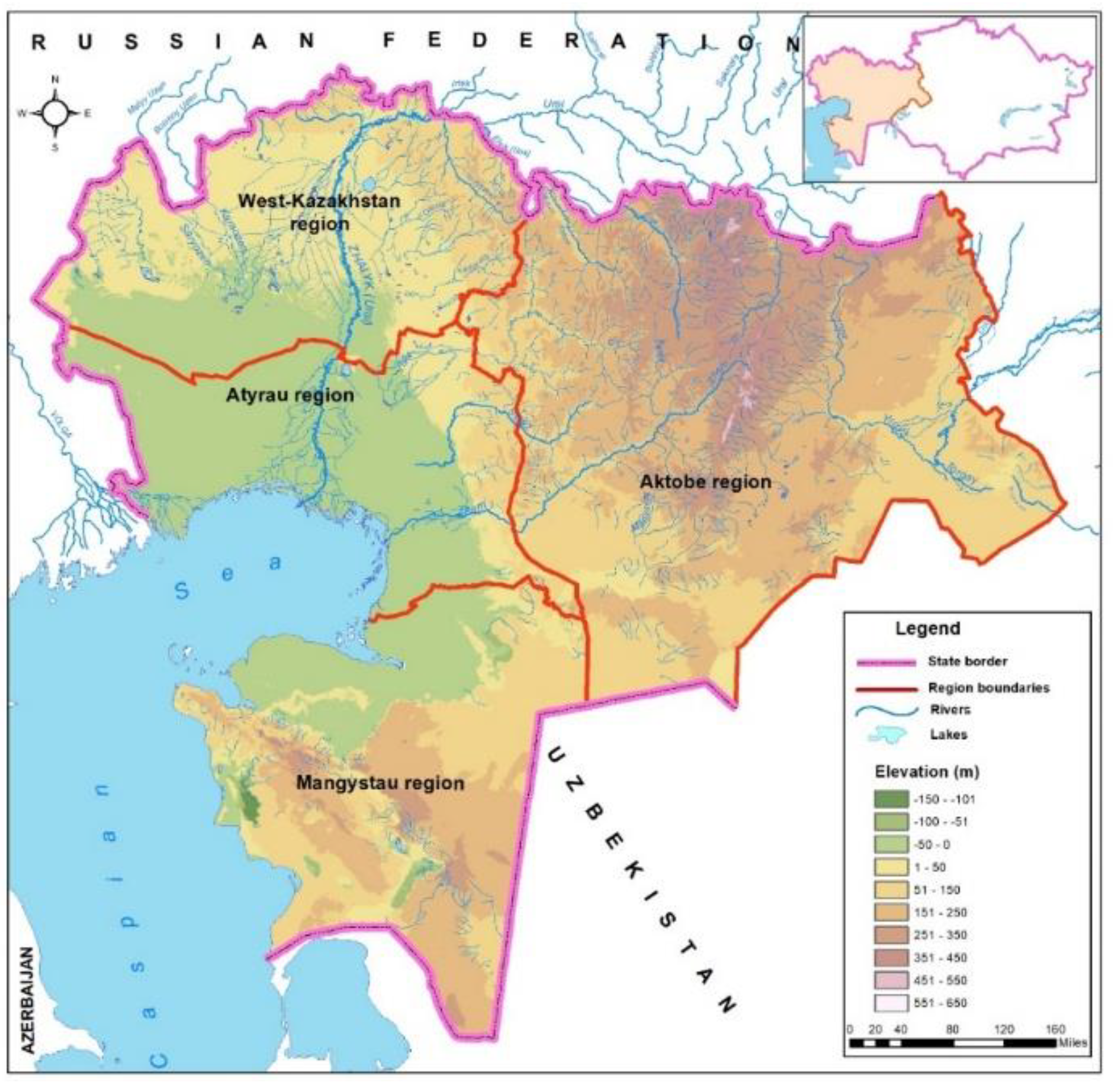
Figure 2.
Specific supply of the population with total river runoff resources in the administrative units of Western Kazakhstan.
Figure 2.
Specific supply of the population with total river runoff resources in the administrative units of Western Kazakhstan.
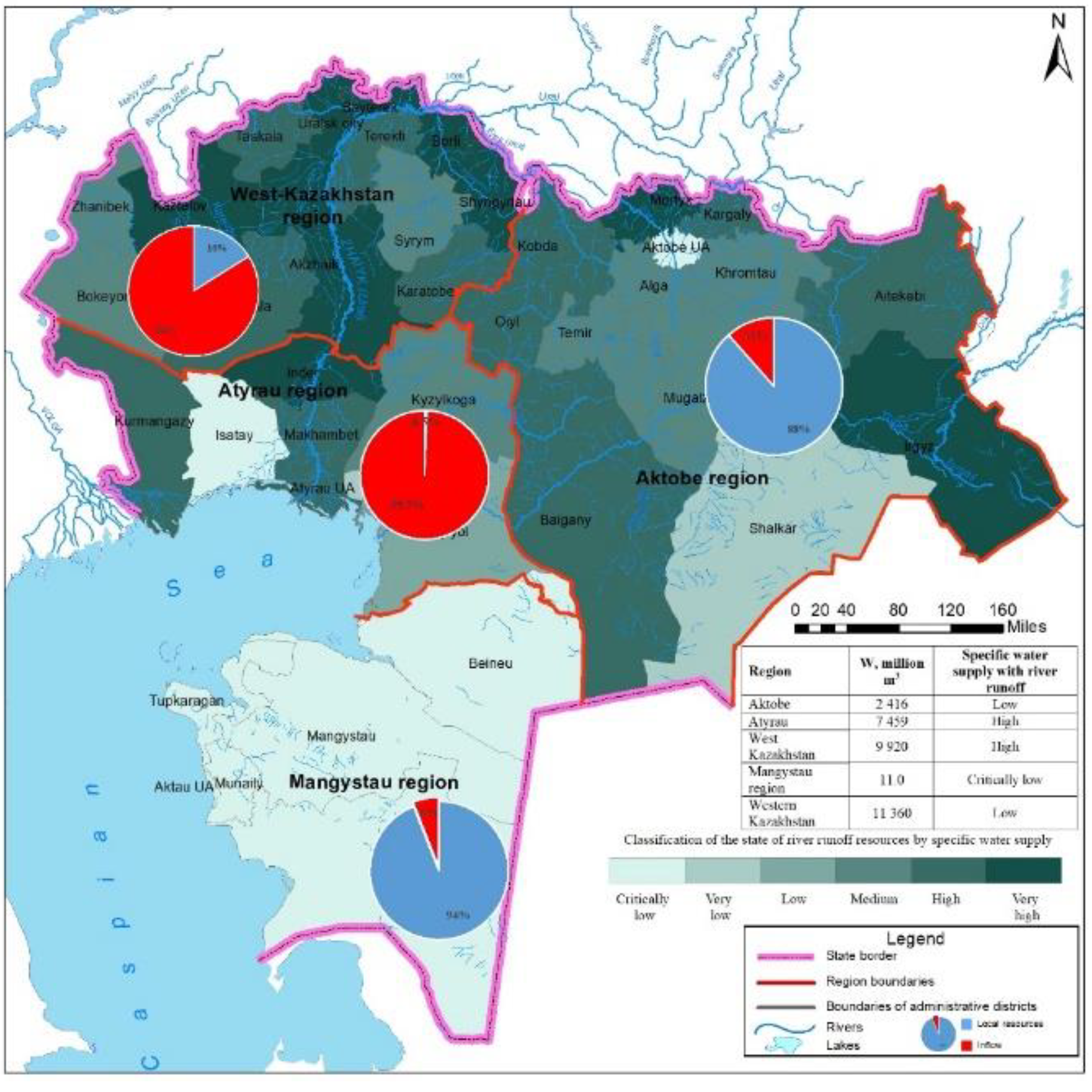
Figure 3.
The load on total river runoff resources by administrative resources of Western Kazakhstan.
Figure 3.
The load on total river runoff resources by administrative resources of Western Kazakhstan.
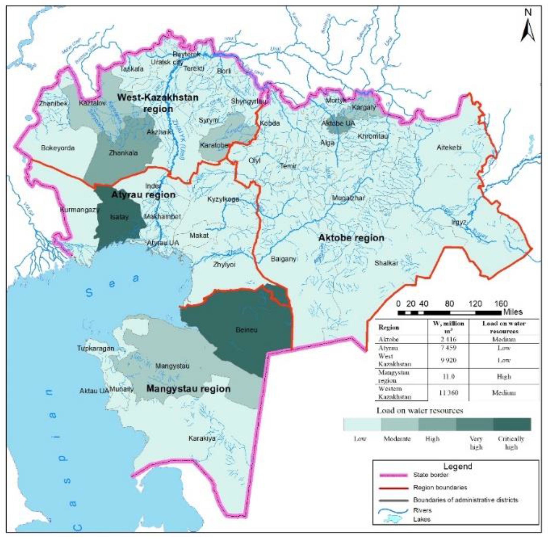
Figure 4.
Indicator of water stress of total river runoff resources by administrative units of Western Kazakhstan.
Figure 4.
Indicator of water stress of total river runoff resources by administrative units of Western Kazakhstan.
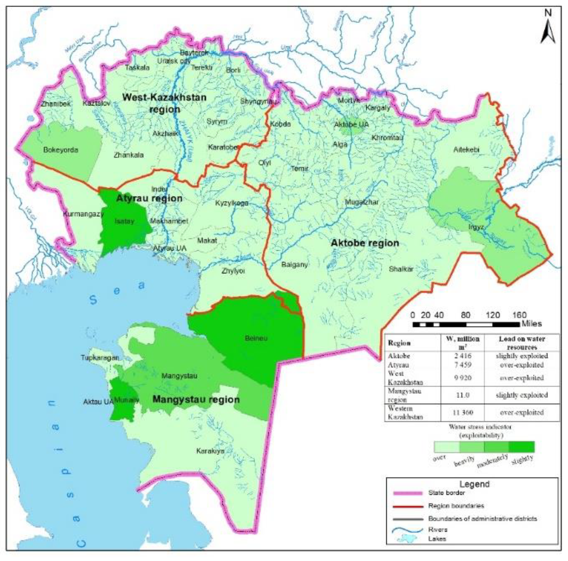
Figure 5.
Specific water supply per capita ensured by lake waters in Western Kazakhstan.
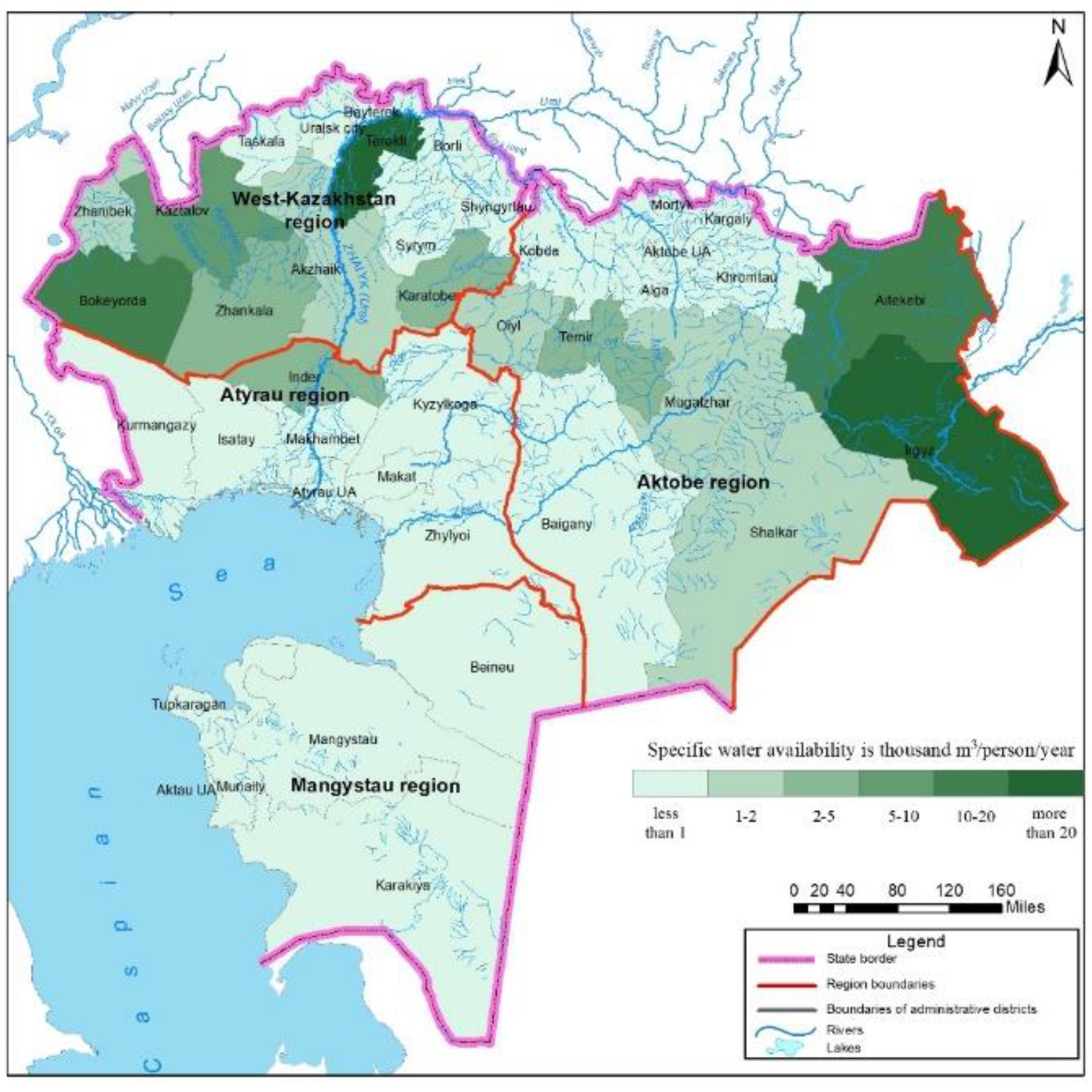
Figure 6.
Specific water supply of the population with the actual total river runoff resources by administrative units of Western Kazakhstan.
Figure 6.
Specific water supply of the population with the actual total river runoff resources by administrative units of Western Kazakhstan.
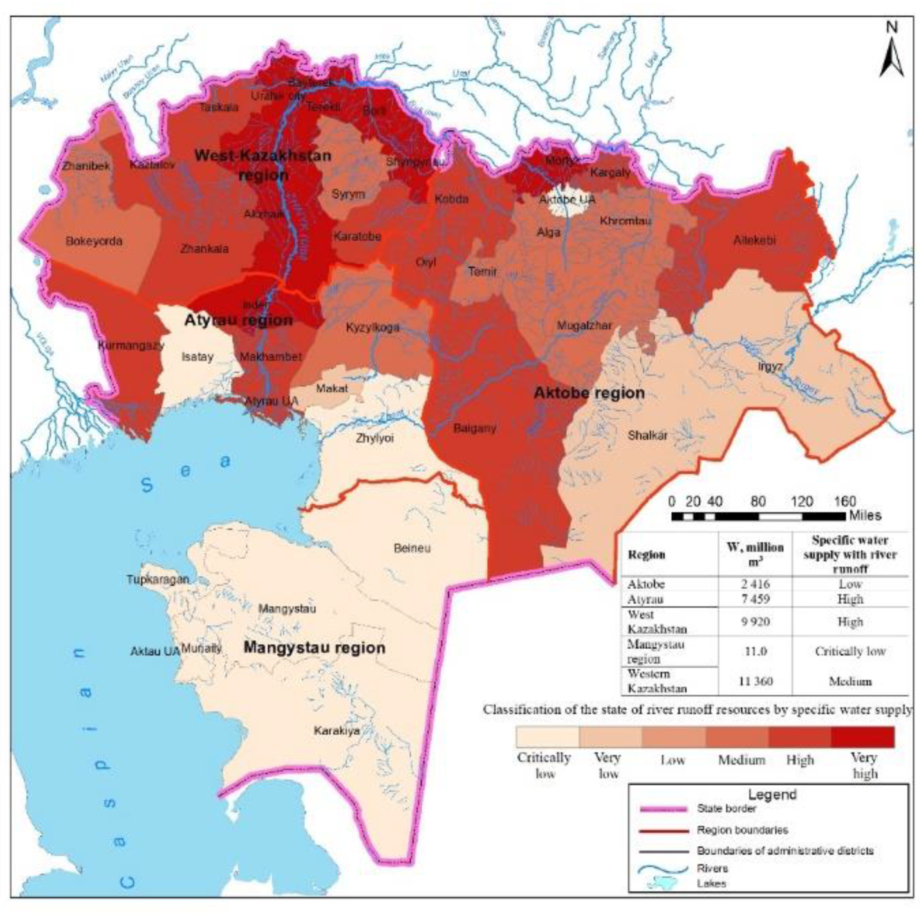
Figure 7.
Specific water supply of the territory with total surface water resources by administrative units of Western Kazakhstan.
Figure 7.
Specific water supply of the territory with total surface water resources by administrative units of Western Kazakhstan.
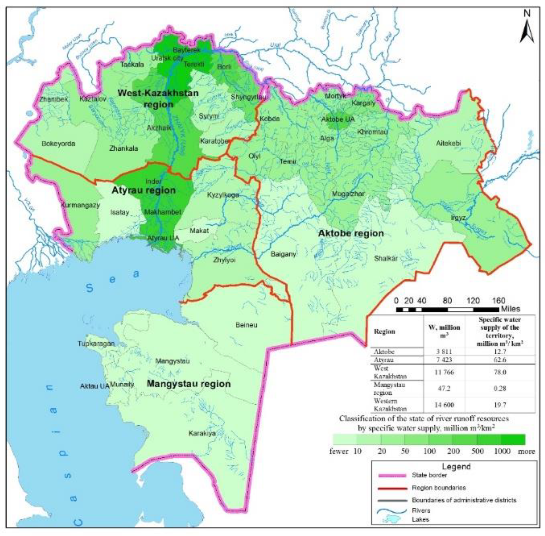
Figure 8.
Load on total surface water resources by administrative units of Western Kazakhstan.
Disclaimer/Publisher’s Note: The statements, opinions and data contained in all publications are solely those of the individual author(s) and contributor(s) and not of MDPI and/or the editor(s). MDPI and/or the editor(s) disclaim responsibility for any injury to people or property resulting from any ideas, methods, instructions or products referred to in the content. |
© 2025 by the authors. Licensee MDPI, Basel, Switzerland. This article is an open access article distributed under the terms and conditions of the Creative Commons Attribution (CC BY) license (http://creativecommons.org/licenses/by/4.0/).
Copyright: This open access article is published under a Creative Commons CC BY 4.0 license, which permit the free download, distribution, and reuse, provided that the author and preprint are cited in any reuse.


