Submitted:
02 May 2025
Posted:
06 May 2025
You are already at the latest version
Abstract
The Strait of Hormuz, a narrow and strategically vital maritime corridor connecting the Persian Gulf to the Gulf of Oman and the Arabian Sea, is one of the most critical chokepoints for global oil transportation. The Strait of Hormuz facilitate the transit of millions of barrels of crude oil daily, and it is indispensable to global energy security. Despite its immense geopolitical importance in the modern world, the geological processes that shaped the Strait of Hormuz remain only partially understood. The region’s origins can be traced back approximately 120 million years ago to the breakup of the Gondwana supercontinent, which set the Indian plate on a rapid northward trajectory. This movement culminated in its collision with the Eurasian plate around 55 million years ago, an event that profoundly altered the region's geology. The impact of this collision not only led to the dramatic uplift of the Himalayan mountain range and the formation of the Tibetan Plateau but also exerted tectonic forces on the Arabian Plate. During or prior to the early stages of Himalayan formation, the Arabian Plate collided with the Eurasian Plate. This tectonic interaction involved the subduction of the oceanic portion of the Arabian Plate beneath the Eurasian Plate, leading to the development of the Makran Range. Eventually the Musandam Peninsula of Arabia collided with the Makran Range, near the southern Zagros Mountains, giving rise to the Musandam Mountains. However, the rapid movement of the Indian Plate toward the north disrupted the nascent Musandam Mountains from the Eurasian plate. This tectonic activity fractured the developing landscape, contributing to the formation of the Strait of Hormuz. The geological processes in this region highlight the dynamic interplay of plate tectonics that shaped its distinctive features. This paper explores the tectonic processes associated with the Indian Plate's trajectory and their role in shaping the Strait of Hormuz, a geological feature of enduring significance to global trade.
Keywords:
Indian plate
; Eurasian plate
; Arabian plate
; Continental drift
; Musandam Peninsula
; Strait of Hormuz
; Persian Gulf
Introduction
The age of Earth is around 4.56 billion years (Hazen, 2010). The theory of continental drift first proposed by Alfred Wegener suggests that the land masses on Earth are continually in motion (Wegener, 1912).
During the Permian period of 250 million years ago the Earth had a single continent, Pangea surrounded by a massive ocean Panthalassa. The Pangea covered a single hemisphere and extended from pole to pole. The Permian-Triassic extinction event, also known as the Great Dying, took place around 252 million years ago and was one of the most significant events in the history of our planet. It represents the divide between the Palaeozoic and the Mesozoic eras. The Triassic Period (252-201 million years ago) began after Earth's worst-ever extinction event devastated life (Wopfner and Jin, 2009; Wang et al. 2021).
In the Triassic period, spanning 250-200 million years ago, Pangea began to break apart into two major landmasses known as Laurasia and Gondwana, separated by the Tethys Sea. Laurasia was made of the present-day continents of North America, Europe, and Asia. Gondwana was made of the present-day continents of Africa, Antarctica, Australia, South America and the Indian subcontinent. The Jurassic period, around 145 million years ago, saw further changes in the arrangement of continents. Finally, during the Cretaceous period, about 65 million years ago, the continents continued to shift and evolve (Wopfner and Jin, 2009; Wang et al. 2021).
Approximately 120 million years ago, the Indian plate began to break away from Gondwana. Over millions of years, the Indian plate drifted steadily northward, gradually approaching the Eurasian plate. When these two colossal plates finally collided, the impact was transformative. This monumental tectonic clash led to the dramatic uplift of the Himalayas and the formation of the Tibetan Plateau. The collision not only created one of the world’s most formidable mountain ranges but also instigated significant geological shifts (Kumar et al. 2007; Chatterjee et al. 2013).
As the Indian plate continued its northward journey, it contributed to the closure of the Tethys Ocean, an ancient ocean that had once separated Laurasia from Gondwana. The closure of the Tethys Ocean led to the formation of new oceanic basins, including the Indian Ocean, which began to take shape as the landmasses realigned. These tectonic processes, which began with the breakup of Gondwana and the subsequent drift of the Indian plate, have been instrumental in shaping the Earth’s current continental arrangement. The relentless movement of these plates has not only redefined the geography of the continents but also played a crucial role in the formation of diverse geological features and oceanic systems that characterize our planet today (Wang et al. 2002).
The convergence of the Indian plate with the Eurasian plate resulted in the formation of some of the world's most significant geological features, including the Himalayan Mountain range and the expansive Tibetan Plateau (Liu et al. 2023). The forceful collision of the Indian plate with the Eurasian plate also led to the fracturing of the Musandam Mountains in the Arabian Peninsula that contributed to the eventual formation of the Strait of Hormuz.
This paper focuses on the formation of the Strait of Hormuz, exploring how the tectonic forces associated with the Indian plate's movement contributed to the development of this crucial maritime chokepoint. The Strait of Hormuz, a vital conduit between the Persian Gulf and the Arabian Sea, plays a significant role in global maritime trade and has been shaped by the intricate and dynamic processes of plate tectonics.
Materials and Methods
The study relies on data derived from the global map available on Google Maps. All measurements were conducted using the suite of tools provided within the platform, ensuring accuracy and consistency. The mapping tools utilized include features such as distance measurement, area calculation, and geolocation pinpointing, which are integral for detailed spatial analysis.
These tools allowed the researchers to determine precise distances, boundaries, and geographic coordinates necessary for the study. By leveraging Google Maps' satellite imagery, and terrain views, the study was able to incorporate a comprehensive and nuanced understanding of the geographic variables involved.
Moreover, the accessibility and user-friendly nature of the platform enabled us to conduct repeated measurements and cross-verifications to minimize potential errors. This methodological approach ensures the reliability and validity of the data collected from Google Maps.
Results
Formation of Musandam Mountains
The movement of the Indian Subcontinent (Indian Plate), in geological terms, was exceptionally swift when juxtaposed with the more gradual motions of neighboring tectonic plates. Notably, the convergence of the Indian Subcontinent with the Eurasian landmass marked a pivotal moment in Earth's history, leading to the dramatic disappearance of the Tethys Ocean and the emergence of the vast Indian Ocean. As the Indian Subcontinent relentlessly pressed against the Eurasian plate, its immense force caused the once-thriving Tethys Ocean to vanish, leaving behind a sprawling expanse of ocean in its wake.
Meanwhile, the Musandam Peninsula of the Arabian plate embarked on its own journey towards the Eurasian plate. While its movement was comparably slower in pace to that of the Indian plate, the collision was no less significant. The Arabian plate's convergence with Eurasia, albeit at a slower pace, contributed to the complex geological landscape of the region.
During or prior to the early stages of the Himalayan formation, the Arabian Plate collided with the Eurasian Plate in a significant tectonic event. This interaction was characterized by the subduction of the oceanic portion of the Arabian Plate beneath the Eurasian Plate, resulting in the formation of the Makran Range. The subduction process created intense pressure and deformation, uplifting sedimentary layers and generating the distinct mountainous terrain of the region. Eventually the Musandam Peninsula of Arabia collided with the Makran Range, near the southern Zagros Mountains, giving rise to the Musandam Mountains. These mountains, situated at the northernmost tip of the Arabian Peninsula, are a testament to the dynamic geological processes associated with plate interactions in the region. The Musandam Mountains movement of its northward trajectory led to the formation of a distinct deformity in the adjacent Southern Zagros Mountain range, further shaping the intricate topography of the region. (Figure 1).
Deformation of the Southern Zagros mountains
The Southern Zagros Mountains exhibits significant deformation attributed to the tectonic collision with the Musandam Mountains (Figure 2). Arching in mountain A is observed as a result of the northern displacement of the B Mountains, induced by compressional stress during the collision. This event has also caused widespread structural disintegration and disorientation of adjacent mountains. A pronounced central rupture is present in Mountain C, interpreted as the product of intense collision. The mountains in D are disoriented during the collision of the Musandam Mountains. These features collectively indicate a complex deformational history driven by active plate convergence in the region.
Formation of Strait of Hormuz
The formation of the Strait of Hormuz is a direct result of intricate tectonic interactions between the Indian plate and the surrounding geological structures. As the Indian plate pursued its relentless northward drift, it encountered the largely immobile Arabian plate, which remained steadfast in its position with minimal tectonic activity. This relative stability of the Arabian plate was particularly significant following the formation of the Musandam Mountains.
As the Indian plate pressed onwards, its northward journey gradually unveiled the continental shelf in South-West Asia, unveiling a landscape altered by millions of years of geological activity. Current topographical maps illustrate how the upper continental crust has migrated approximately 100 kilometers alongside the relentless movement of the Indian plate (Figure 3). This interaction created substantial tectonic stress and pressure on the surrounding regions, including the then recently formed Musandam Mountains. The immense forces exerted by the Indian plate led to the fracturing and rupture of the Musandam Mountains within the Arabian plate. This tectonic rupture was a critical event that initiated the formation of the Strait of Hormuz. The strait, a narrow and strategically crucial waterway, emerged as a result of these geological stresses (Figure 3).
The Strait of Hormuz now serves as a vital maritime corridor, linking the Persian Gulf with the Gulf of Oman and the Arabian Sea beyond. Its strategic importance cannot be overstated, as it facilitates major international trade routes and transportation networks. The formation of this crucial strait highlights the intricate and dynamic nature of Earth's tectonic processes and their far-reaching impacts on global geography and geopolitics.
Formation of Western Indian Mountain Ranges
Based on the global map, we could speculate that the collision of the western flank of the Indian plate with the Eurasian plate triggered a series of geological events that significantly shaped the region's topography. The mountains of the Eurasian plate near Brar, adjacent to the Indian plate, may have undergone significant transformation during the collision between these two major tectonic plates. This monumental geological event, which began millions of years ago, initiated a series of intense compressional forces that profoundly altered the landscape. As the Indian plate pushed northward into the Eurasian plate, the immense pressure and stress caused the Earth's crust to fold, fracture, and uplift, resulting in the dramatic elevation of mountain ranges.
Near Brar, these transformative processes would have included the formation of complex fold structures, thrust faults, and the uplift of metamorphic rocks to the surface. The collision likely resulted in the reconfiguration of pre-existing geological formations, creating a highly varied and rugged terrain. This area would have experienced significant seismic activity, contributing to the ongoing mountain-building processes that continue to shape the region today.
The tectonic activity resulting from the collision of the Indian and Eurasian plates led to the formation of the Sulaiman Fold, a prominent mountain range distinguished by its intricate fold structures (Figure 4). In contrast to the Eastern Indian Mountains, which have been more susceptible to erosion due to tropical wet conditions, the mountains in the western region have remained remarkably well-preserved. This preservation is largely due to the arid climate that dominates the area, which has played a crucial role in maintaining these geological formations' distinctive features over millions of years.
The southernmost point of the Western Indica Mountain Range is Cape Monze. This geographical landmark, also known as Ras Muari, marks the transition from the rugged terrain of the Central Makran Range to the coastal plains that extend towards the Arabian Sea. Cape Monze is a significant feature not only for its geographical importance but also for its unique ecological and geological characteristics. The cape's cliffs and rocky outcrops provide a striking contrast to the surrounding landscapes, and the area is known for its diverse marine life and rich biodiversity.
At the junction of Indian and Eurasian plates is the Las Bela triangular plain, encompassing the Miani Hor lagoon (Figure 4). This plain, located in the southwestern part of Pakistan's Balochistan province, represents a dynamic interplay of tectonic forces that have shaped the landscape over millions of years. The collision and subsequent interaction between the Indian and Eurasian plates have resulted in complex geological processes that contributed to the formation of the Las Bela plain. The convergence of these plates caused substantial deformation of the Earth's crust, leading to the creation of this unique triangular-shaped plain. The area is characterized by a mixture of alluvial deposits, coastal features, and sedimentary formations that reflect the region's tectonic and climatic history.
Miani Hor, a coastal lagoon within the Las Bela plain, adds to the area's ecological and geological importance. This lagoon is a vital habitat for diverse marine and bird life and serves as an essential site for local fisheries. The interaction between marine processes and tectonic activity has shaped Miani Hor's coastline, creating a distinctive environment where the land meets the Arabian Sea.
Formation of Eastern Indian Mountains
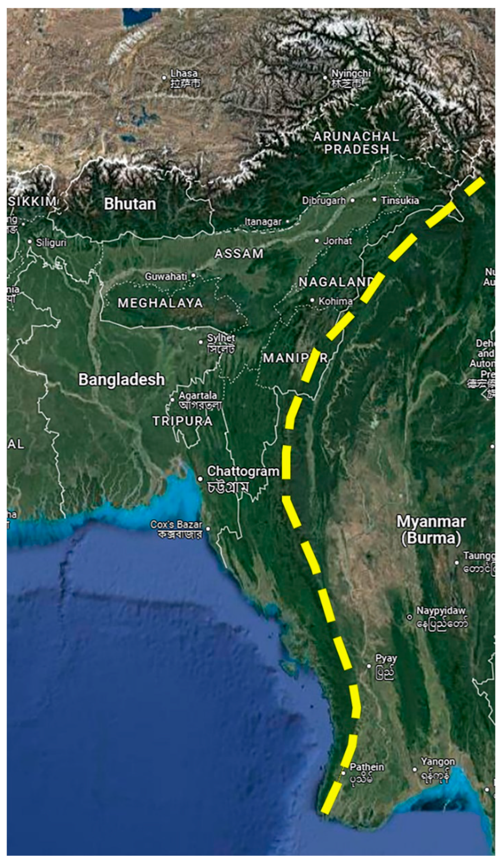
The eastern segment of the Indian plate is distinguished by a notable arc-shaped geological formation that we name as the East Indica Mountains. This mountain range, characterized by its lush tropical forests, encompasses several significant subranges, including the Purvanchal Mountains, which are situated in Eastern India. Extending from the Eastern Himalayas, the Eastern Indian Mountains stretch all the way to Cape Negrais in Burma (Myanmar) (Figure 5). This extensive range not only marks the eastern boundary of the Indian plate but also serves as a vital ecological zone, hosting a rich diversity of flora and fauna within its dense tropical forest cover.
The formation of the Eastern Indian Mountains is a result of the complex tectonic interactions between the Indian plate and a fragment of the ancient supercontinent Gondwana known as Argoland. Argoland, which was part of Gondwana, began to fragment and drift away from the supercontinent. Over time, this fragment formed islands in Southeast Asia and Western Burma (Advokaat and van Hinsbergen, 2024). The collision between the Indian plate (East) and this fragment of Argoland played a crucial role in the uplift and formation of the Eastern Indian Mountains.
The geological and ecological significance of the Eastern Indian Mountains extends beyond their mere formation. The range’s varied topography and climate contribute to a unique and rich biodiversity, making it a crucial area for scientific study and environmental conservation. The interaction between tectonic forces and ecological processes in this region exemplifies the dynamic nature of Earth’s geological evolution.
Discussion
Earth stands uniquely among its planetary peers within our solar system as the sole rocky planet characterized by active plate tectonics. This dynamic geological phenomenon involves the lithospheric plates continually shifting, forging a crucial connection between the Earth's deep interior and its surface reservoirs. Consequently, the traces of plate tectonics leave an indelible mark in the geological record through various processes such as rifting, collision events, and subduction zones. These geological activities not only shape the Earth's surface but also play a pivotal role in the planet's evolution and the distribution of its geological resources over millennia (Palin et al. 2020).
Convection currents within the Earth's mantle play a crucial role in driving the movement of continents and the deformation of the Earth's crust. These currents are generated by the heat produced from the decay of radioactive elements within the mantle. This heat causes material in the mantle to rise as it warms and to sink as it cools, creating a cyclical flow. This convective motion exerts enough force to shift and maneuver the Earth's lithospheric plates, resulting in the gradual and ongoing drift of continents. As the tectonic plates interact at their boundaries, they trigger various geological phenomena such as earthquakes, volcanic eruptions, and the formation of mountain ranges (Holmes, 1931). This theory has provided a cohesive framework for understanding these dynamic processes and represents a significant breakthrough in geological science. It is acknowledged as a fundamental element of Earth’s dynamic system, fundamentally influencing the planet's surface and its geological activity across the globe.
More than 167 million years ago, India was an integral part of the vast supercontinent known as Gondwana, spanning much of the Southern Hemisphere. Approximately 120 million years ago, India began its gradual separation from Gondwana, initiating a slow northward journey at a leisurely pace of about 5 centimeters per year. This initial movement set the stage for a remarkable geological saga that would unfold over millions of years. Around 80 million years ago, India's trajectory underwent a dramatic acceleration, surging northward at a staggering rate of about 15 centimeters per year—twice as fast as the swiftest contemporary tectonic drift. This rapid movement was catalyzed by the dynamic interaction of tectonic plates deep within the Earth's mantle. Specifically, India was propelled northward by the combined forces of two subduction zones—regions where one tectonic plate plunges beneath another, dragging connected landmasses along with it (Chatterjee et al. 2013; Gibbons et al. 2015; Jagoutz et al. 2015).
The convergence of these two subduction zones provided a dual pulling force, effectively doubling India's migration speed. This extraordinary pace ultimately led to the momentous collision between the Indian plate and the Eurasian plate approximately 50 million years ago. The impact of this collision reshaped the Earth's surface, giving rise to the Himalayan mountain range, whose towering peaks stand as a testament to the colossal forces at play in our planet's geological history. The formation of the Himalayas and the Tibetan plateau was not merely a geological event; it profoundly influenced global climate patterns, ocean currents, and the distribution of life across continents. The uplift of immense sedimentary layers from the ancient Tethys Sea, now towering several miles above sea level, further underscores the monumental scale of these geological processes (Chatterjee et al. 2013; Gibbons et al. 2015).
While the Himalayas, located to the north of the Indian plate, have been extensively studied and are well understood, the mountain ranges situated to the west and east of the Indian plate remain less thoroughly explored. The intricate geological processes and tectonic interactions that have shaped these lesser-studied regions are not yet fully elucidated. Understanding these western and eastern mountain ranges and is crucial for a comprehensive grasp of the broader tectonic and geological framework of the Indian plate. Further investigation could reveal important insights into the interactions between the Indian plate and its neighboring tectonic regions, contributing to our overall understanding of mountain building processes and the dynamic nature of Earth's lithosphere.
At present, the Indian plate is advancing in a north-eastern direction at an approximate rate of 5 centimeters per year (Gao et al., 2022). This movement is a significant component of the Earth's tectonic dynamics and has profound implications for the geological processes occurring in the region. It is plausible to hypothesize that in the past, the Indian plate was moving in a north-western direction, as evidenced by the orientation and formation of mountain ranges in the northern and western regions of the plate. This historical movement likely played a significant role in shaping the geological features observed today. As the Indian plate progressed north-westward, it exerted considerable pressure on the surrounding regions, contributing to the uplift and formation of the prominent mountain ranges found in these areas. This tectonic activity also had a substantial impact on the continental shelf in South-West Asia. Over time, the movement of the Indian plate led to the gradual exposure and modification of this continental shelf, further influencing the region's geological landscape.
Current topographical maps reveal that the upper continental crust has migrated approximately 100 kilometers inland in response to the relentless movement of the Indian plate. This shift underscores the dynamic nature of tectonic processes and their long-term effects on the Earth's surface. The migration of the crust is a testament to the ongoing tectonic forces that continue to reshape the landscape, reflecting the historical and ongoing interactions between the Indian plate and its neighboring geological structures. The historical rapid movement of the Indian plate, relative to the slower motion of the Arabian plate, contributed to the fracture of the Musandam Mountains eventually leading to the formation of the Strait of Hormuz. This contrast in plate velocities played a crucial role in opening this important waterway, further illustrating the profound effects of tectonic activity on regional geological features.
Though the Strait of Hormuz formation is geologically old, the formation of Persian Gulf, a shallow epicontinental sea located between the Arabian Peninsula and southwestern Iran is geologically recent. Approximately 20,000 years ago, during the Last Glacial Maximum (LGM), much of the Earth's water was locked in vast ice sheets, causing global sea levels to be significantly lower than today—by as much as 120 to 130 meters (Clark et al. 2009). As a result, the area that now forms the Persian Gulf was predominantly a dry, low-lying basin. At its lowest point, the Persian Gulf region was not submerged but instead served as an expansive arid plain. This plain was fed by the confluence of major rivers such as the Tigris, Euphrates, and Karun. These rivers created a fertile delta-like environment that supported diverse ecosystems and potentially early human settlements. Archaeological and geological evidence suggests that this area may have been a migration corridor or even a cradle for some human populations before being inundated.
Around 15,000 years ago, as the Earth's climate began to warm at the end of the Pleistocene epoch, the glacial ice sheets started melting. This melting triggered a significant and gradual rise in global sea levels, a process known as the Holocene transgression. Over the next several millennia, rising waters from the Indian Ocean breached the Strait of Hormuz, flooding the low-lying basin that is now the Persian Gulf. By approximately 6,000 to 7,000 years ago, the sea level stabilized near its current position, forming the gulf as we know it today (Hosseinyar et al. 2021).
The Persian Gulf remains a vital ecological and economic zone. Its geological history has contributed to the formation of extensive hydrocarbon reserves, making it one of the richest oil and gas regions in the world. Understanding the processes that shaped the Persian Gulf offers valuable insights into past climate changes and serves as a reference for studying modern sea level rise and its potential impacts on low-lying coastal regions globally.
Overall, our study reveals that the rapid movement of the Indian plate has significantly influenced the formation of several major geological features. This dynamic tectonic activity not only gave rise to the Himalayas and the Tibetan Plateau but also contributed to the development of the Western and Eastern Mountain ranges of the Indian subcontinent. Additionally, the plate's rapid motion played a crucial role in the fracturing the Musandam Mountains and the opening of the Strait of Hormuz. Detailed geological fieldwork and chemical analyses will provide more accurate data to further refine our understanding of these processes.
Funding
None.
Data Availability
All the data is published in the manuscript.
Conflicts of Interest
The author declares no competing interest.
Ethics Statement
None.
Consent to Publish
Not applicable.
Consent to Participate
Not applicable.
References
- Advokaat, E.L.; van Hinsbergen, D.J.J. Finding Argoland: Reconstructing a microcontinental archipelago from the SE Asian accretionary orogen. Gondwana Research. Gondwana Research 2024, 128, 161–263. [Google Scholar] [CrossRef]
- Chatterjee, S.; Goswami, A.; Scotese, C.R. The longest voyage: Tectonic, magmatic, and paleoclimatic evolution of the Indian plate during its northward flight from Gondwana to Asia. Gondwana Research 2013, 23, 238–267. [Google Scholar] [CrossRef]
- Clark, P.U.; Dyke, S.A.; Shakun, D.J. , et al. The last glacial maximum. Science 2009, 325, 710–714. [Google Scholar] [CrossRef] [PubMed]
- Gao, Y.; Yang, J.; Zheng, Y. Eastward subduction of the Indian plate beneath the Indo-Myanmese arc revealed by teleseismic P-wave tomography. Earthquake Science 2022, 35, 243–262. [Google Scholar] [CrossRef]
- Gibbons, A.D.; Zahirovic, S.; Müller, R.D.; Whittaker, J.M.; Yatheesh, V. A tectonic model reconciling evidence for the collisions between India, Eurasia and intra-oceanic arcs of the central-eastern Tethys. Gondwana Research 2015, 28, 451–492. [Google Scholar] [CrossRef]
- Hazen, R.M. How Old is Earth, and How Do We Know? Evolution: Education and Outreach 2010, 3, 198–205. [Google Scholar] [CrossRef]
- Holmes, A. ,. Radioactivity and Earth movements. Trans. Geol. Soc. Glasg. 1931, 18, 559–606. [Google Scholar] [CrossRef]
- Hosseinyar, G.; Behbahani, R.; Moussavi-Harami, R.; Lak, R.; Kuijpers, A. Holocene sea-level changes of the Persian Gulf. Quaternary International 2021, 571, 26–45. [Google Scholar] [CrossRef]
- Jagoutz, O.; Royden, L.; Holt, A.; et al. Anomalously fast convergence of India and Eurasia caused by double subduction. Nature Geosci 2015, 8, 475–478. [Google Scholar] [CrossRef]
- Kumar, P.; Yuan, X.; Kumar, M.R.; Kind, R.; Li, X.; Chadha, R.K. The rapid drift of the Indian tectonic plate. Nature 2007, 449, 894–7. [Google Scholar] [CrossRef] [PubMed]
- Liu, L.; Liu, L.; Morgan, J.P.; et al. New constraints on Cenozoic subduction between India and Tibet. Nat Commun 2023, 14, 1963. [Google Scholar] [CrossRef] [PubMed]
- Palin, R.M.; Santosh, M.; Cao, W.; Li, S.S.; Hernandez-Uribe, D.; Parsons, A. Secular change and the onset of plate tectonics on Earth. Earth-Science Reviews 2020, 207, 103172. [Google Scholar] [CrossRef]
- Wang, C.; Li, X.; Hu, X.; Jansa, L.F. Latest marine horizon north of Qomolangma (Mt Everest): implications for closure of Tethys seaway and collision tectonics. Terra Nova 2002, 14, 114–120. [Google Scholar] [CrossRef]
- Wang, C.; Mitchell, R.N.; Murphy, J.B.; Peng, P.; Spencer, C.J. The role of megacontinents in the supercontinent cycle. Geology 2021, 49, 402–406. [Google Scholar] [CrossRef]
- Wegener, A Die Entstehung der Kontinente. Dr. A. Petermanns Mitteilungen aus Justus Perthes' Geographischer Anstalt. 1912, 58, pp. 185–195, 253.
- Wopfner, H.; Jin, X.C. Pangea Megasequences of Tethyan Gondwana-margin reflect global changes of climate and tectonism in Late Palaeozoic and Early Triassic times—A review. Palaeoworld 2009, 18, 169–192. [Google Scholar] [CrossRef]
Figure 1.
The Musandam Peninsula of the Arabian Plate briefly collided with the mountains of the Eurasian plate forming the Musandam Mountains. The collision of the Musandam Peninsula deformed the Southern Eurasian mountains.
Figure 1.
The Musandam Peninsula of the Arabian Plate briefly collided with the mountains of the Eurasian plate forming the Musandam Mountains. The collision of the Musandam Peninsula deformed the Southern Eurasian mountains.
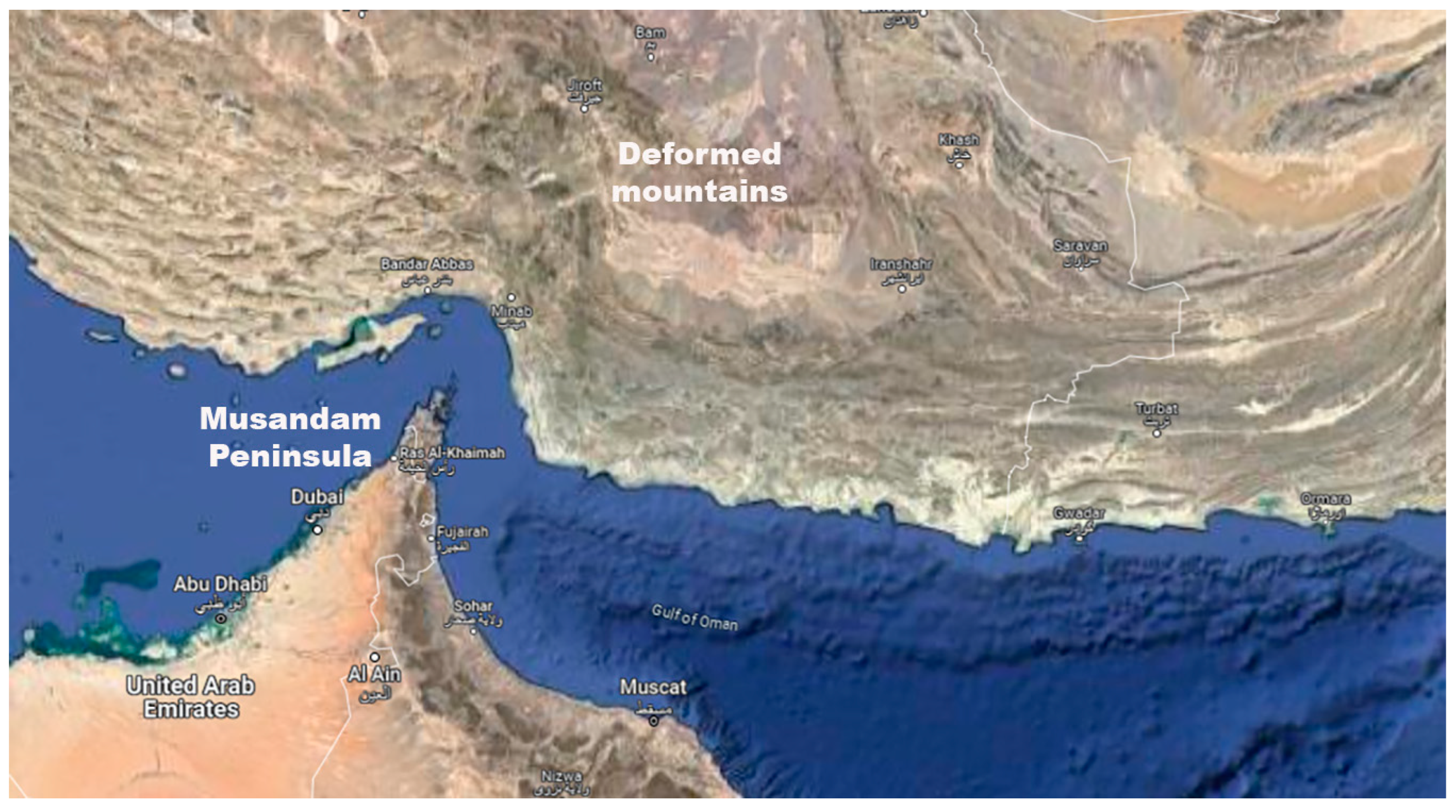
Figure 2.
Deformation of the Southern Zagros mountains. A. The mountain is arched due to the movement of the B Mountains further south, caused by the collision with the Musandam Mountains. B. The mountains are disintegrated due to the collision with the Musandam Mountains. C. The mountain exhibits a central rupture resulting from tectonic deformation caused by its collision with the Musandam Mountains. D. The mountains are disoriented due to the collision with the Musandam Mountains.
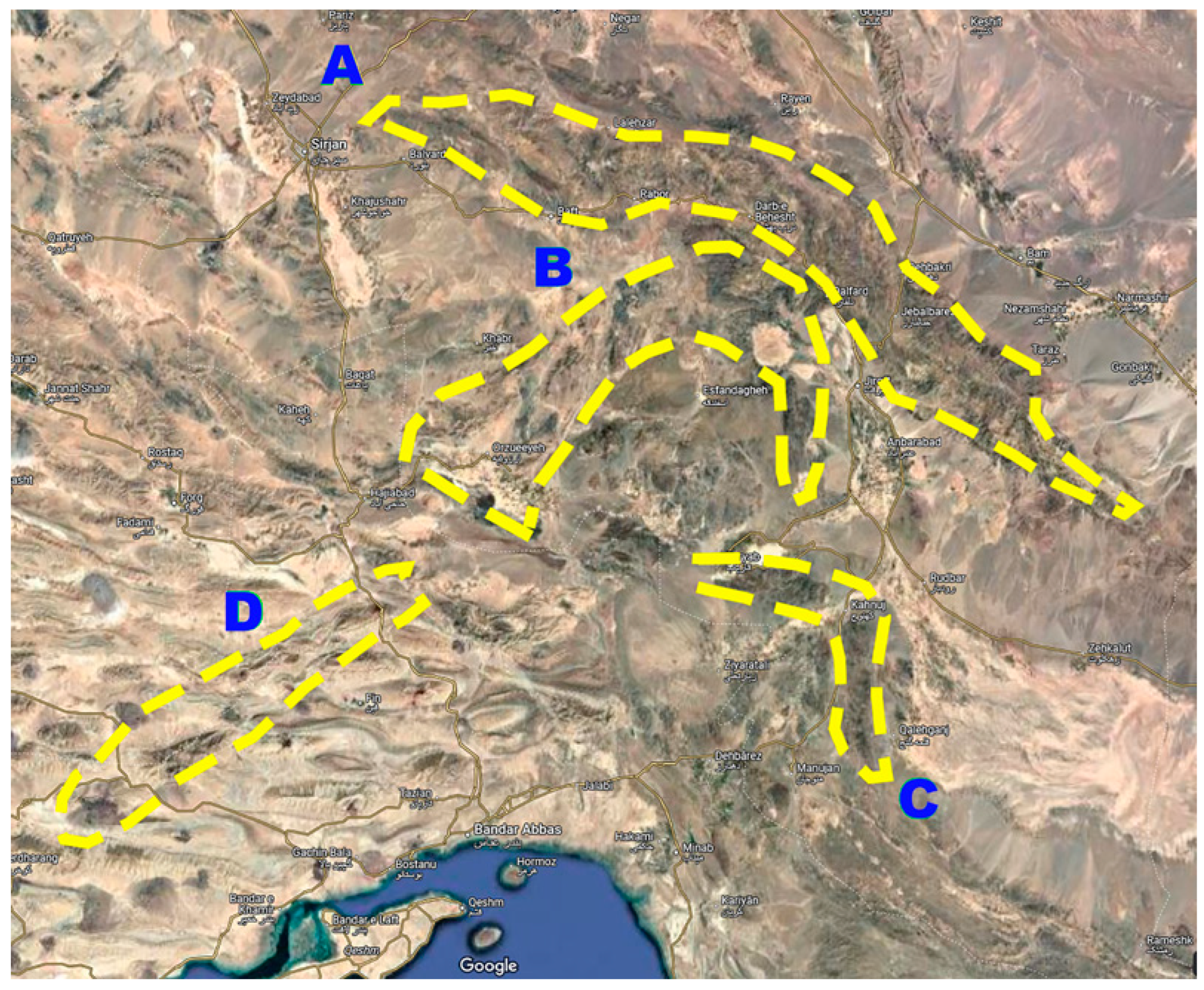
Figure 3.
As the Indian plate moved northward it unveiled the continental shelf of South West Asia. Current topographical maps show that the upper continental crust has migrated approximately 100 kilometers due to the movement of the Indian plate. The movement of the Eurasian plate along with the Indian plate fractured the Musandam Mountains thereby forming the Strait of Hormuz.
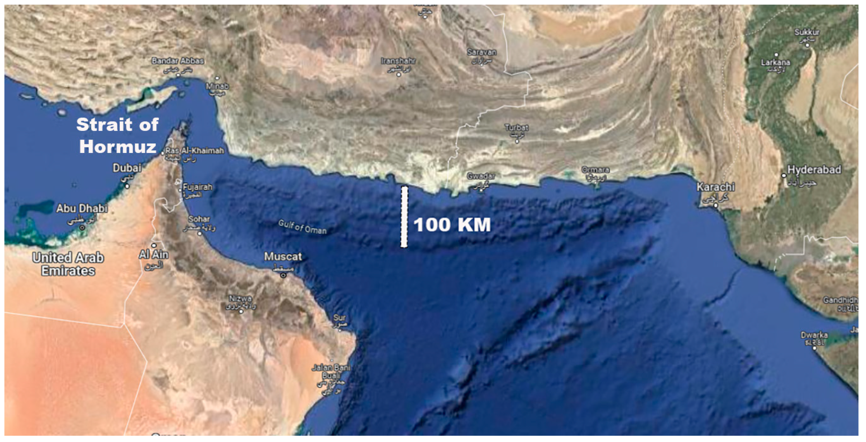
Figure 4.
The tectonic activity resulting from the collision of the Indian and Eurasian plates led to the formation of the Sulaiman Fold in the north-western region of the Indian plate. At the junction of Indian and Eurasian plates is the Las Bela triangular plain, encompassing the Miani Hor lagoon. The collision and subsequent interaction between the Indian and Eurasian plates have resulted in complex geological processes that contributed to the formation of the Las Bela plain.
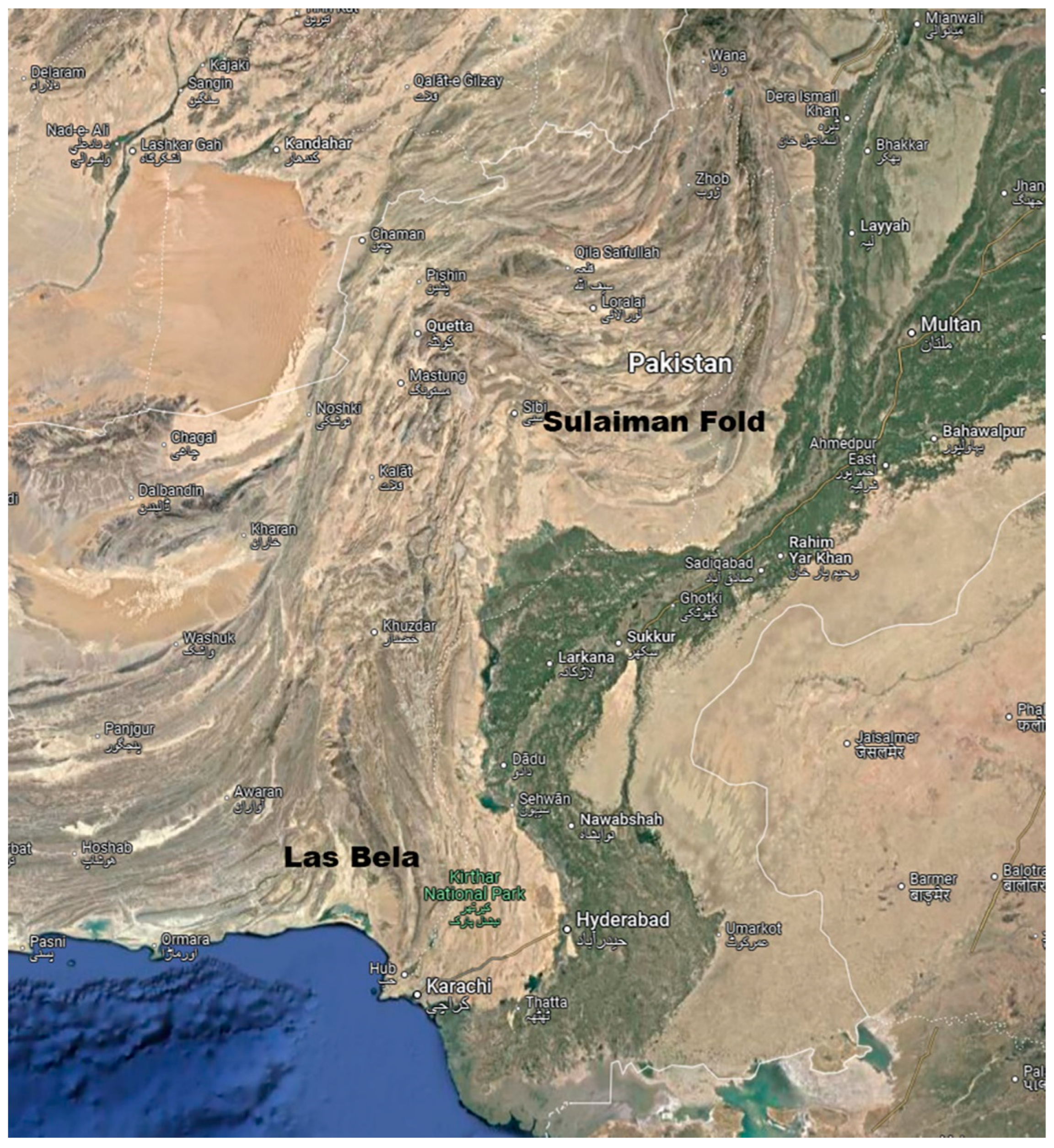
Figure 5.
The eastern segment of the Indian plate is distinguished by a notable arc-shaped geological formation (East Indica Mountains) (yellow dotted line). Extending from the Eastern Himalayas, the East Indica Mountains stretch all the way to Cape Negrais in Burma (Myanmar).
Figure 5.
The eastern segment of the Indian plate is distinguished by a notable arc-shaped geological formation (East Indica Mountains) (yellow dotted line). Extending from the Eastern Himalayas, the East Indica Mountains stretch all the way to Cape Negrais in Burma (Myanmar).
Disclaimer/Publisher’s Note: The statements, opinions and data contained in all publications are solely those of the individual author(s) and contributor(s) and not of MDPI and/or the editor(s). MDPI and/or the editor(s) disclaim responsibility for any injury to people or property resulting from any ideas, methods, instructions or products referred to in the content. |
© 2025 by the authors. Licensee MDPI, Basel, Switzerland. This article is an open access article distributed under the terms and conditions of the Creative Commons Attribution (CC BY) license (http://creativecommons.org/licenses/by/4.0/).
Copyright: This open access article is published under a Creative Commons CC BY 4.0 license, which permit the free download, distribution, and reuse, provided that the author and preprint are cited in any reuse.


