Submitted:
31 January 2025
Posted:
03 February 2025
You are already at the latest version
Abstract
Sediment and nutrient retention (SNR) are a key ecosystem service for maintaining water quality and preventing soil erosion, particularly in watershed areas that are vulnerable to land-use dynamics and climate change. This study focuses on the upper Beht watershed, the most ecologically significant basin within the Ifrane National Park (INP), which plays an essential role in sustaining downstream water systems while being exposed to pressures from human activities and land-use transformations. This research analyzed historical land use data from 1992 to 2022 using Google Earth Engine. Next, employed the Integrated Valuation of Ecosystem Services and Tradeoffs (InVEST 3.10.2) software to quantify and map the impacts of ongoing land use changes on the watershed's capacity to retain sediments and nutrients. Finally, used the damage costs avoided method for economic assessment of SNR service. Our findings indicate a positive trend in SNR service provision following the park's establishment, with notable improvements in areas targeted by reforestation and conservation interventions. This study underscores the significance of continuous SNR service monitoring, offering park managers robust data to advocate sustained conservation efforts among policymakers and relevant stakeholders. Furthermore, these results highlight the need to engage local communities in sustainable land management practices, fostering a collaborative approach to enhance the ecological resilience and long-term integrity of Ifrane National Park.
Keywords:
Sediment and Nutrient Retention
; Land Use Dynamics
; Google Earth Engine
; InVEST Software
; Economic Assessment
; Ifrane National Park
Introduction
Ecosystem services, defined as the benefits humans derive from natural ecosystems, ranging from the provision of resources, to the regulation of environmental processes. These services are indispensable for human well-being [1]. Their recognition gained prominence with the study of Costanza in 1997, which introduced economic valuation as a method to highlight their importance and integrate them into decision-making processes [2]. Water regulation ecosystem services (WRES) are key ecosystem services wich play a critical role in maintaining water balance [3,4]. Provided by ecosystems such as forests, grasslands and wetlands, these services are vital for ensuring water quality, and mitigating soil erosion and flooding [5,6]. Monetizing these services become a necessity to support their inclusion in policy-making and environmental planning [7].
In Morocco, the importance of WRES is especially pronounced in regions such as the Middle Atlas, where forested watersheds are crucial for maintaining hydrological stability, supporting agricultural productivity, and ensuring urban water supply [8,10]. The upper BEHT watershed is one of the INP’s most ecologically and hydrologically significant basins. It encompasses extensive mountainous forests of Atlas Cedar (Cedrus Atlantica) and contributes over 80% of the country’s mobilizable water resources. This watershed provides essential services for downstream water availability, agricultural productivity, and urban consumption [11,12].
However, the region’s capacity to deliver critical WRES has been jeopardized by Land-Use And Land-Cover Changes (LULCC), including grasslands degradation, agricultural intensification, and urban expansion [13]. Established in 2004, the INP aims to mitigate these threats by conserving the region’s unique biodiversity and maintaining essential ecosystem services. The park seeks to reconcile various land-use categories (state-owned, collective, and private lands) while promoting conservation and sustainable resource utilization through participatory approaches. The park’s managers have implement significant efforts to protect natural assets, such us: reforestation and restoration initiatives, wildlife conservation efforts, ecotourism projects, and eco-development programs [14]. Despite these efforts, few studies have specifically examined the impact of LULCC on conservation outcomes, especially regarding their effect on the economic value of WRES provided by the park’s watersheds [11,15,16,17,18,19,20].
This study addresses this critical research gap by offering a localized and detailed assessment of WRES in the upper BEHT watershed. Using remote sensing data processed in Google Earth Engine (GEE) platform and spatial modeling tools—specifically the Sediment Delivery Ratio (SDR) and Nutrient Delivery Ratio (NDR) models within the InVEST models —the research quantifies and maps changes in sediment and nutrient retention as a principal WRES over three decades (1992–2022). This work incorporates on-the-ground verification to enhance the accuracy of its findings and provides robust insights into the evolution of WRES before and after the park’s establishment. In addition to biophysical assessment, this study conducts an economic valuation of WRES using the damage costs avoided approach, highlighting their monetary significance.
By evaluating the evolution of WRES biophysical quantity and economic value in relation to LULCC and conservation efforts, this study underscores the importance of restoration activities in enhancing ecosystem resilience. It also demonstrates how economic valuation can inform sustainable conservation planning and policymaking, paving the way for innovative financing mechanisms that align ecological preservation with socio-economic objectives. The study first introduces the study area (Section 2.1) and outlines the methodological approach (Section 2.2), including the mapping of LULC for 1992, 2002, 2012, and 2022 (Section 2.2.1), the quantification of WRES for each year (Section 2.2.2), and the economic assessment of these services (Section 2.2.3). The results reveal a positive trend in the provision of WRES following the park’s establishment, with significant improvements in areas targeted by reforestation and conservation. The economic value of WRES reaching 10,000 USD per year. This study highlights the necessity of ongoing WRES monitoring, equipping park managers with valuable data to support continued conservation initiatives, and advocate to integrate the economic value of WRES provided by protected area such the INP, into policy and decision making, environmental management planning, and financial mechanisms as payment for ecosystem services to preserve water resource.
Materials and Methods
2.1. Study Area
The study area encompasses the upper BEHT watershed; the most ecologically and hydrologically significant basin within Ifrane National Park, situated in the western part of the central Middle Atlas region in Morocco (Figure 1).
The INP aims to conserve the region’s unique biodiversity and ecosystems while promoting the sustainable management of natural resources. It also supports local development by fostering environmentally responsible practices and sustainable economic activities, such as ecotourism and agro ecology [21]. The park’s watersheds contribute over 80% of Morocco’s mobilizable water resources, with the upper BEHT watershed representing a particularly vital hydrological basin, which plays a critical role in water regulation and supply, serving as a primary source for downstream reservoirs and agricultural systems. Its significance lies in its capacity to capture precipitation, regulate seasonal flows, and mitigate sediment transport, making it essential for sustaining water availability in the region [21]. Three main soil types within the park based on substrate are: volcanic, calcareous, and dolomitic. The park is characterized by two distinct bioclimates: subhumid and humid. These climates exhibit cool conditions at mid-altitudes, cold temperatures across the plateau, and very cold extremes at the summits of the eastern mountain ranges [21]. The park hosts 22% of Morocco’s vascular plant species, with a high endemism rate of 25%, exemplified by the iconic Atlas cedar (Cedrus atlantica). Additionally, it supports 33% of the country’s mammalian species, including the endangered Barbary macaque (Macaca sylvanus) [22].
2.2. Mapping Historical LULCC
Satellite data for the years 1992, 2002, 2012, and 2022 were analyzed to assess LULCC within the INP over three decades. These datasets, obtained from the Google Earth Engine (GEE) platform, were derived from the Landsat 5, Landsat7, Landsat 8, and Landsat 9 satellite series. The analysis incorporated all available spectral bands, as well as the Normalized Difference Vegetation Index (NDVI), to enable a detailed examination of spatial and temporal LULCC.
Preprocessing steps, including radiometric and atmospheric corrections, were applied to ensure consistency and comparability across the different time periods [23,24]. LULC classification was performed using the Random Forest (RF) machine learning algorithm, selected for its reliability and high accuracy in remote sensing studies [25,26]. RF leverages ensemble learning by aggregating predictions from multiple decision trees, reducing overfitting and increasing model stability. Its inherent feature selection capabilities are particularly useful for identifying significant variables, such as spectral bands or vegetation indices, critical for accurate classification. RF has been shown to perform well in various LU/LC studies, including integration with advanced techniques like Markov chain models and multi-layer perceptrons for change prediction, achieving high accuracy and interpretability [27]. Combining RF with multi-sensor data, such as optical and SAR images, has further enhanced classification accuracy, achieving over 96% accuracy in some studies [28]. While RF generally excels, challenges remain in distinguishing spectrally similar classes and achieving consistent precision and recall measures, especially in heterogeneous landscapes [29]. Despite these limitations, RF’s balance of simplicity, accuracy, and computational efficiency makes it a preferred choice for large-scale LULC classification in GEE.
In this study, supervised classification categorized LULC into six classes: forests, shrubs, crops, built-up areas, water, and bare soil. The selection of study years, encompassing both pre- and post-establishment periods of the park (created in 2004), provided insights into the evolution of LULC before and after the park’s creation. Validation of classification results was conducted using confusion matrices and the Kappa index, demonstrating satisfactory accuracy levels for all time periods analyzed.
2.3. Quantifying Water Regulating Ecosystem Services Using InVEST
After analyzing historical LULCC, we quantify WRES using the InVEST models, in particular the Sediment Delivery Ratio (SDR) and Nutrient Delivery Ratio (NDR) models [17,18,19,20]. Annual soil loss and the sediment delivery ratio, defined as the proportion of soil loss reaching the stream, are computed by the SDR model, and it is assumed that sediment is transported from the source to the stream and then to the watershed outlet. The Revised Universal Soil Loss Equation (RUSLE) is employed by the model to estimate annual soil loss. The spatial movement of nutrient masses is explained by the NDR model through a simple mass balance methodology, in which LULC and loading rates are considered to determine nutrient loads [30]. The input rasters for the InVEST models are presented in Table 1.
2.4. Economic Assessment of Water Regulating Ecosystem Services
In this study, a revealed preference economic valuation method is employed, specifically, the damage costs avoided method, which quantifies expenses that would have been incurred in the absence of a specific environmental function [36,40]. Damages related to the absence of Water Regulating Ecosystem Services are primarily associated with potential degradation affecting agricultural lands and rangelands.
Loss in agricultural yields is obtained using the relationship of Den Biggelaar et al. (2004) [41] (Equation (1)).
with:
r = EwP1.224 * 0.0114
- r: Relative decrease in yield due to erosion (%).
- EwP: Erosion rate (t/ha/year).
Then, the relative decrease in yield due to erosion was multiplied by the average crop yield to determine the decline in yield in t/ha (2).
with:
∆R = r * Average crop yield
- ∆R: Relative decrease in yield due to erosion (t/ha);
- r: Relative decrease in yield due to erosion (%).
Forage yield losses are determined using Table 2, which provides the percentage of forage productivity losses for each erosion class [42].
Once the damage quantities had been determined, their economic costs were estimated. For agricultural damages, the market prices of cereals were applied, as more than 58% of the cultivated land in the study area is dedicated to cereal crops [43]. For rangeland damages, the price of fodder barley was relied upon, since the value of one forage unit is considered equivalent to one kilogram of barley. The evaluation was carried out for multiple reference years (1992, 2002, 2012, and 2022). Accordingly, the market prices of cereals and barley corresponding to each year were used to ensure accurate cost estimation [44].
3. Results
3.1. Historical LULCC Within the INP Watershed
The analysis revealed a significant increase in forest cover between 2012 and 2022, the decade following the park establishment (Figure 2). Prior to the park’s creation, the region experienced a gradual decline in forested areas due to various anthropogenic activities, including deforestation and land conversion for agricultural purposes. However, the implementation of conservation measures and sustainable management practices within the park has led to a remarkable recovery and expansion of the forest ecosystem.
An analysis of conservation initiatives implemented within the park reveals significant achievements. During the period 2012/2022, more than 2,000 hectares were successfully reforested, and over 4,000 hectares were placed under protection or designated for restoration and reforestation. These areas were managed through a participatory approach involving local communities. The number of local associations engaged in park management increased from 5 at the park’s inception to 12 at present, reflecting a growing community commitment. Furthermore, there was a nearly 50% reduction in forest-related offenses during this time. These positive indicators align with the findings from remote sensing analysis, which demonstrated an increase in forest cover, thereby confirming the tangible impact of these conservation efforts [45].
Table 3 illustrates the evolution of each LULC class within the INP watershed.
For the different years analyzed, we achieved a Kappa coefficient value equal to or greater than 90% (Table 4), indicating a near-perfect agreement between the reference classification and the automated classification performed using Google Earth Engine. This high level of concordance signifies that the model accurately replicated the reference data.
The classification accuracy results for the years 1992, 2002, 2012, and 2022 show a clear trend of improvement in the model’s performance over time, as indicated by the increasing overall accuracy and the decreasing disagreement metrics. The overall accuracy increased progressively, starting from 87.5% in 1992 and reaching an impressive 98.96% in 2022. This steady improvement suggests significant advancements in the classification model’s ability to align with reference data. The high accuracy achieved in 2022 highlights the impact of improved input data quality and enhanced feature extraction or modeling techniques over the study period.
The quantity disagreement, which reflects errors related to mismatches in class proportions, exhibited an initial increase from 2.78% in 1992 to 6.45% in 2002. This could be attributed to limitations in the availability or representativeness of the training data during that period. However, this metric showed a consistent decline thereafter, reducing to 4.26% in 2012 and further to 1.04% in 2022. The observed reduction in quantity disagreement over time indicates that the classification model has progressively become better at predicting the correct number of pixels for each class, aligning more closely with the reference data distributions.
Similarly, allocation disagreement, which measures spatial misallocations of classes, was notably high in 1992 (9.72%) and 2002 (11.29%), indicating significant challenges in correctly assigning class locations during the earlier years. However, this metric saw a dramatic reduction to 2.13% in 2012 and was completely eliminated in 2022 (0.00%). The absence of allocation disagreement in 2022 demonstrates a perfect spatial alignment between the predicted and reference data, suggesting substantial advancements in the classification model’s spatial accuracy. These improvements may be attributed to better-distributed training data, higher-resolution satellite imagery, or the adoption of more robust classification algorithms.
Overall, the results indicate that the classification process has undergone considerable refinement over the study period. The observed improvements in both accuracy and disagreement metrics emphasize the critical role of evolving data quality and modeling techniques in achieving reliable LULC mapping. These trends highlight the importance of continuous innovation in remote sensing methodologies to ensure accurate and spatially coherent classification outcomes.
3.2. Water Regulating Ecosystem Services Evolution
Our results indicate a notable reduction in soil erosion within the INP watershed following the establishment of the park (2012/2022) (Figure 3). This decline can be attributed to the significant expansion of forest cover, which has enhanced soil stability and reduced erosion vulnerability. These findings underscore the critical role of forest restoration and protection within protected areas in mitigating soil degradation.
However, the observed reduction in erosion could have been more substantial if not for the simultaneous expansion of agricultural activities. The increase in agricultural lands has heightened soil sensitivity to erosion, partially offsetting the benefits provided by forest cover recovery. This highlights the importance of integrated land management strategies that balance agricultural development with ecosystem conservation to maximize the benefits of soil erosion control.
Figure 4 illustrates the spatial evolution of the biophysical quantity of sediment loss within the INP watershed, highlighting variations across the study period.
Our results also indicate a significant reduction in nutrient export, specifically nitrogen and phosphorus, within the INP watershed following the establishment of the park (2012/2022) (Figure 5). This decline can similarly be attributed to the expansion of forest cover, which demonstrates a higher efficiency in nutrient retention compared to other LULC types. These findings further highlight the pivotal role of forest restoration and protection in enhancing ecosystem services.
However, this reduction could have been significantly greater if not for the concurrent expansion of intensive agricultural activities and the substantial decrease in grasslands. These grasslands, which play a vital role in nutrient retention and erosion control, have either been degraded into bare soil due to overgrazing or converted into agricultural fields. This shift in land use has not only compromised the ecological benefits provided by grasslands but has also amplified nutrient runoff. Intensive agricultural practices often involve excessive use of fertilizers, which, combined with the loss of natural vegetation, exacerbate nutrient leaching into downstream systems. As a result, while reforestation efforts have improved certain ecosystem services, the negative impacts of agricultural expansion have partially offset these gains.
This duality highlights the critical need for integrated and sustainable land management strategies that balance forest conservation with the growing demands for agricultural development. Policies should prioritize sustainable practices such as agroforestry, soil conservation techniques, and the restoration of degraded grasslands to mitigate the environmental impacts of agriculture. Encouraging local communities to adopt such practices through education and incentives can play a key role in maintaining the functionality of nutrient retention services.
3.3. Economic Assessment of Water Regulating Ecosystem Services
The results show also an increase in agricultural yield losses cost (Table 5), driven by the expansion of agricultural areas, even after the park’s establishment, leading to greater erosion-related damages. Conversely, forage yield losses cost has declined (Table 6), primarily due to a significant reduction in grazing land, which has been converted to agriculture or built-up areas. These findings highlight that, despite efforts to restore forest ecosystems and enhance ecosystem services, agricultural expansion continues to undermine these gains, resulting in a low economic value, which would have been much higher. This underscores the need for interventions to modify agricultural practices and promote sustainable land use for grazing areas to improve environmental outcomes.
The economic value of the WRES is determined based on the potential on-site losses in agricultural and forage yields that would occur in the absence of this ecosystem service. The results show that the WRES value was negative before the park’s establishment. However, after the park’s creation (in 2004), the WRES value became positive, estimated at 10,000 USD/Year (Figure 8).
4. Discussion
The results of the spatio-temporal and economic assessment of the WRES in Ifrane National Park highlight significant trends at both spatial and economic levels. Prior to the establishment of the park in 2004, the WRES value was negative, estimated at -7,000 USD/year. This negative value was primarily attributed to agricultural expansion, which led to increased sediment and nutrient losses, negatively impacting both the environment and agricultural yields.
However, following the creation of the park, the WRES value became positive, reaching 10,000 USD/year. This positive shift can be attributed to the expansion of forest cover, which enhanced sediment and nutrient retention, thereby reducing erosion-related losses and contributing positively to the ecosystem. The improvement in soil quality and reduction in erosion were particularly notable in areas where forest cover was restored. Despite this positive trend, the WRES value could have been significantly higher had it not been for the continued agricultural expansion and land conversion to built-up areas after the park’s establishment.
The conversion of grazing lands into agricultural lands and built-up zones further negatively impacted nutrient retention. While agricultural yields increased, this growth was accompanied by a heightened vulnerability of soils to erosion, reducing the park’s ability to provide optimal sediment and nutrient retention services. The decrease in grazing land area, primarily converted into agricultural land considered more profitable, led to a loss of the land’s retention capacity [46,47,48,49,50,51].
These findings underscore the importance of integrated land management strategies that balance ecosystem protection with agricultural development. Despite efforts to restore forest ecosystems, the continued expansion of agriculture and urbanization continues to mitigate these environmental gains. The results suggest the need for sustainable agricultural practices and the preservation of grazing lands to optimize ecosystem services such as sediment and nutrient retention. Sustainable land management strategies should be implemented to maximize nutrient retention and limit negative environmental impacts while supporting local economic activities [52,53,54,55,56,57].
It is crucial for park managers to invest in advanced tools focused on the continuous mapping and assessment of the evolution of the park ecosystem services. This approach would support data-driven decision-making and more adaptive management strategies to address ecosystem changes effectively [58].
The findings from this study can serve as a powerful tool for advocating sustained conservation efforts among policymakers and relevant stakeholders. By showcasing the dynamics of ecosystem services, these insights can drive support for the implementation of more comprehensive and long-term conservation policies [59].
Awareness campaigns highlighting the value of ecosystem services should be prioritized to encourage land-use practices that align with the park’s conservation goals and enhance its ecological resilience [60].
The results of this study should be systematically integrated into the upcoming revisions of the Park Management and Development Plan (PAG). Considering the trends in ecosystem service evolution will inform more effective conservation strategies and contribute to the sustainable management of park resources [61].
Author Contributions
Conceptualization, O.S. and A.K.; methodology, O.S.; software, O.S. and Z.D.; validation, A.K.; formal analysis, O.S.; investigation, O.S.; resources, O.S.; data curation, O.S.; writing—original draft preparation, O.S.; writing—review and editing, O.S.; Z.D. and A.K.; visualization, O.S.; supervision, A.K.;.
Conflicts of Interest
The authors declare no conflicts of interest.
Appendix A: Biophysical Tables of SDR and NDR Models

Table A1.
Biophysical tables of SDR model.
| Lucode | LULC_Desc | Usle_c | Usle_p |
| 1 | Crops | 0.19 | 1 |
| 2 | Baresoil | 1 | 1 |
| 3 | Water | 0.04 | 1 |
| 4 | Built up area | 0.1 | 1 |
| 5 | Forest | 0.003 | 1 |
| 6 | Shrubs | 0.5 | 1 |
Table A2.
Biophysical tables of NDR model.
| lucode | LULC_desc | load_n | eff_n | load_p | eff_p | crit_len_p | crit_len_n | |
| 1 | Crops | 12.42 | 0.25 | 2.21 | 0.25 | 150 | 150 | |
| 2 | Baresoil | 1 | 0.05 | 0.1 | 0.05 | 150 | 150 | |
| 3 | Water | 0 | 0 | 0 | 0 | 150 | 150 | |
| 4 | Built up area | 12.78 | 0.08 | 4.17 | 0.05 | 150 | 150 | |
| 5 | Forest | 2.2 | 0.83 | 0.275 | 0.8 | 150 | 150 | |
| 6 | Shrubs | 6.28 | 0.1 | 1.35 | 0.25 | 150 | 150 |
References
- Assessment, M. E. (2003). Millennium ecosystem assessment. Ecosystems.
- Costanza, R., d’Arge, R., De Groot, R., Farber, S., Grasso, M., Hannon, B., ... & Van Den Belt, M. (1997). The value of the world’s ecosystem services and natural capital. nature, 387(6630), 253-260. [CrossRef]
- Julián, García-Comendador., Yuni, Artahni., Kellie, Gonçalves. (2022). Hydrological response of two contrasting small Mediterranean Mountainous catchments in the Middle Atlas - Morocco. [CrossRef]
- Msaddek, Mohamed., El, Garouani, Abdelkader., Kimbowa, George. (2021). 2. Modeling the Hydrological Impacts of Vegetation Cover Changes in the Upper Oum Er-Rbia Watershed (Morocco). Journal of Ecological Engineering. [CrossRef]
- Sisay, Mekonnen. (2017). 5. Review on the Role of Forest Landscapes in Watershed Hydrologic Processes. Journal of environment and earth science.
- Carlos, Cayuela, Linares. (2019). 4. Ecohydrology of mediterranean headwater catchments. The role of forest in the redistribution and isotopic modification of water fluxes.
- Brauman, K. A., Daily, G. C., Duarte, T. K. E., & Mooney, H. A. (2007). The nature and value of ecosystem services: an overview highlighting hydrologic services. Annu. Rev. Environ. Resour., 32(1), 67-98. [CrossRef]
- Abdelaziz, El-Bouhali., Mhamed, Amyay., Khadija, El, Ouazani, Ech-Chahdi. (2023). 1. Recent variations of water area in the Middle Atlas lakes (Morocco): A response to drought severity and land use changes. [CrossRef]
- Ileana, Pătru-Stupariu., Constantina, Alina, Hossu., Simona, R., Grădinaru., Andreea, Nita., Mihai-Sorin, Stupariu., Alina, Huzui-Stoiculescu., Athanasios, Alexandru, Gavrilidis. (2020). 4. A Review of Changes in Mountain Land Use and Ecosystem Services: From Theory to Practice. Land. [CrossRef]
- Elhoucein, Layati., Mohamed, El, Ghachi. (2024). 4. Oued Lakhdar watershed (Morocco), monitoring land use/cover changes: remote sensing and GIS approach. Geology, ecology, and landscapes. [CrossRef]
- Oumayma, Sadgui., Abdellatif, Khattabi. (2024). Economic Assessment of Hydrologic Ecosystem Services in Morocco’s Protected Areas: A Case Study of Ifrane National Park. Sustainability, 16(20):8800-8800. [CrossRef]
- Nadia, Ennaji., Hasan, OUAKHIR., Mohammed, ABAHROUR., Velibor, Spalević., Branislav, DUDIC. (2024). 5. Impact of watershed management practices on vegetation, land use changes, and soil erosion in River Basins of the Atlas, Morocco. Notulae Botanicae Horti Agrobotanici Cluj-napoca. [CrossRef]
- Hamid, Boubekraoui., Zineb, Attar., Yazid, Maouni., Abdelilah, Ghallab., Radhwane, Saidi., Abdelfettah, Maouni. (2024). 4. Forest Loss Drivers and Landscape Pressures in a Northern Moroccan Protected Areas’ Network: Introducing a Novel Approach for Conservation Effectiveness Assessment. Conservation. [CrossRef]
- Hajar, Lamhamedi., Sebastien, Lizin., Nele, Witters., Robert, M., Malina., Abdelilah, Baguare. (2021). 6. The recreational value of a peri-urban forest in Morocco. Urban Forestry & Urban Greening. [CrossRef]
- Mohammed, AMRAOUI., Larbi, BOUABIDI., Mohamed, Amrani., Hassan, Ouakhir., Branislav, DUDIC., Tin, Lukić., Velibor, SPALEVIC. (2024). 3. Land use dynamics and soil conservation strategies in the el kssiba region, atlas mountains of morocco. The Journal “Agriculture and Forestry. [CrossRef]
- Nassima, Moutaoikil., Brahim, Benzougagh., Mohamed, Mastere., Bouchta, El, Fellah., Houda, Lamrani. (2024). 8. The impact of soil erosion on environments: A case study of the Oued Beht Watershed (Morocco). BIO web of conferences. [CrossRef]
- Kwadwo, Kyenkyehene, Kusi., Abdellatif, Khattabi., Nadia, Mhammdi., Said, Lahssini. (2020). 5. Prospective evaluation of the impact of land use change on ecosystem services in the Ourika watershed, Morocco. Land Use Policy. [CrossRef]
- Kwadwo, Kyenkyehene, Kusi., Abdellatif, Khattabi., Nadia, Mhammdi. (2021). 7. Integrated assessment of ecosystem services in response to land use change and management activities in Morocco. Arabian Journal of Geosciences. [CrossRef]
- Kusi, K. K., Khattabi, A., & Mhammdi, N. (2023). Evaluating the impacts of land use and climate changes on water ecosystem services in the Souss watershed, Morocco. Arabian Journal of Geosciences, 16(2), 126. [CrossRef]
- Kusi, K. K., Khattabi, A., & Mhammdi, N. (2023). Analyzing the impact of land use change on ecosystem service value in the main watersheds of Morocco. Environment, Development and Sustainability, 25(3), 2688-2715. [CrossRef]
- Achehboune, M.J. Etat Actuel du Dépérissement du Cèdre de l’Atlas au Moyen Atlas Central en Relation Avec la Station et la Sylviculture, Cas des Forêts: JbelAoua Sud et Ait Youssfi de l’Amekla (Canton de LallaMimouna). Ph.D. Thesis, 3rd Cycle National Forest Engineering School, Salé, Morocco, 2006; 137p.
- National Agency of Water And Forests. (2007). Plan for the Development and Management of Ifrane National Park; Internal document; Rabat, Morroco; pp. 1–180.
- Hansen, M. C., & Loveland, T. R. (2012). A review of large area monitoring of land cover change using Landsat data. Remote Sensing of Environment, 122, 66–74. [CrossRef]
- Roy, D. P., Wulder, M. A., Loveland, T. R., et al. (2014). Landsat-8: Science and product vision for terrestrial global change research. Remote Sensing of Environment, 145, 154–172. [CrossRef]
- Belgiu, M., & Drăguţ, L. (2016). Random forest in remote sensing: A review. ISPRS Journal of Photogrammetry and Remote Sensing, 114, 24–31. [CrossRef]
- Lambin, E. F., Turner, B. L., Geist, H. J., et al. (2001). The causes of land-use and land-cover change: Moving beyond the myths. Global Environmental Change, 11(4), 261–269. [CrossRef]
- Tahraoui, A., & Kheddam, R. (2024). LULC Change Detection Using Combined Machine and Deep Learning Classifiers. 403–408. [CrossRef]
- Al-Ruzouq, R., Shanableh, A., Gibril, M. B. A., & Kalantar, B. (2019). Multi-scale correlation-based feature selection and random forest classification for LULC mapping from the integration of SAR and optical Sentinel images. 11157, 58–70. [CrossRef]
- Lin, C., & Doyog, N. D. (2023). Challenges of retrieving LULC information in rural-forest mosaic landscapes using random forest technique. Forests, 14(4), 816. [CrossRef]
- Naturel Capital Project. Invest User Guide_Invest documentation. Available online: http://releases.naturalcapitalproject.org/invest-userguide/latest/index.html (accessed on 15 November 2023).
- Achiban, H.; Taous, A.; El-Khantoury, I.; el Mderssa, M.; et Amechrouq, A. Quantification of soil loss in various lithological areas of the western Middle Atlas Central: Application to the Ras-Elma, Tamelalet and Sebab watershed (Tigrigra watershed, Morocco). In E3S Web of Conferences; EDP Sciences: Les Ulis, France, 2018; Volume 37, p. 04003, 8p.
- Benez-Secanho, F. J., & Dwivedi, P. (2019). Does quantification of ecosystem services depend upon scale (resolution and extent)? A case study using the InVEST nutrient delivery ratio model in Georgia, United States. Environments, 6(5), 52. [CrossRef]
- CHIRPS Data: Rainfall Estimates from Rain Gauge and Satellite Observations, Climate Hazards Center. Available online: https://www.chc.ucsb.edu/data/chirps (accessed on 3 September 2024).
- Earth Science Data Systems (ESDS) Program of the National Aeronautics and Space Administration of the United States of America. Available online: https://earthdata.nasa.gov (accessed on 15 August 2021).
- Rango, A.; Arnoldus, H.M.J. Aménagement des bassins versants. Cah. Tech. FAO 1987, 36, p1–11.
- Giuliano, Rocco, Romanazzi., Giovanni, Ottomano, Palmisano., Marilisa, Cioffi., Vincenzo, Leronni., Ervin, Toromani., Romina, Koto., Annalisa, De, Boni., Claudio, Acciani., Rocco, Roma. (2024). 7. A Cost–Benefit Analysis for the Economic Evaluation of Ecosystem Services Lost Due to Erosion in a Mediterranean River Basin. Land. [CrossRef]
- Élia, Pires-Marques., Cristina, Chaves., Lígia, Pinto. (2021). 9. Biophysical and monetary quantification of ecosystem services in a mountain region: the case of avoided soil erosion. Environment, Development and Sustainability,. [CrossRef]
- Panos, Panagos., Francis, Anthony, Matthews., E., Patault., C., De, Michele., Emanuele, Quaranta., Nejc, Bezak., Konstantinos, Kaffas., Epari, Ritesh, Patro., Christian, Auel., Anton, J., Schleiss., Arthur, Nicolaus, Fendrich., Leonidas, Liakos., Elise, Van, Eynde., Diana, Vieira., Pasquale, Borrelli. (2023). 1. Understanding the cost of soil erosion: An assessment of the sediment removal costs from the reservoirs of the European union. Journal of Cleaner Production. [CrossRef]
- Joseph, A., Herriges., Catherine, L., Kling. (2008). 9. Revealed preference approaches to environmental valuation.
- Amara, Tijani., Fakhfakh, Hamadi. (2013). 1. Quantifying and Accounting for Environmental Costs by the Avoidance Cost’s Method: The Case of a Tunisian Firm. [CrossRef]
- Biggelaar, C.D.; Lal, R.; Wiebe, K.; Breneman, V. The global impact of soil erosion on productivity. I. Absolute and relative erosion-induced yield losses. Adv. Agron. 2004, 81, 1–48.
- Jorio, A. Le Coût de la Dégradation de l’Environnement au Maroc. Chapitre 5 “Sols”. Environment and Natural Resources Global Practice Discussion Paper. World Bank Group Rep. 2017, 105633-MA, 49–64.
- DPA. (2024). Agricultural yield in Ifrane province. Internal document.
- ONICL (2024). Cereals and forage market prices from 2002 to 2024. Internal document.
- ANEF (2022).The evolution of Reforested areas, areas under protection, forest offenses, and sylvopastoral management associations from 2012 to 2022. Internal document.
- Muhammad, Imran., Fanoos, Haider. (2024). Forest ecosystem services of water-related filtration and regulation, a multi-source assessment and economic valuation in Mangla watershed. Water supply. [CrossRef]
- Soumen, Bisui., Sambhunath, Roy., Debashish, Sengupta., Gouri, Sankar, Bhunia., Pravat, Kumar, Shit. (2021). Assessment of ecosystem services values in response to land use/land cover change in tropical forest. [CrossRef]
- Zenebe, Adimassu., Lulseged, Tamene., Degefie, T., Degefie. (2020). The influence of grazing and cultivation on runoff, soil erosion, and soil nutrient export in the central highlands of Ethiopia. Ecological processes. [CrossRef]
- Leon, Josip, Telak., Igor, Bogunović., Jesús, Rodrigo-Comino. (2019). Land Management Impacts on Soil Water Erosion and Loss of Nutrients. [CrossRef]
- Albaro, Blanco, Imbert., Illovis, Fernández, Betancourt., Teudys, Limeres, Jiménez., Marianela, Cintra, Arencibia., José, Ramón, Fuentes, Quintana., Roberto, Sanchez, Rojas., Antonio, Barzaga, Lobaina., Abel, Castillo, Duran. (2017). Agricultural Practices to Mitigate Soil Degradation and Increase Carbon Capture.
- Zenebe, Adimassu., Lulseged, Tamene., Degefie, T., Degefie. (2020). The influence of grazing and cultivation on runoff, soil erosion, and soil nutrient export in the central highlands of Ethiopia. Ecological processes. [CrossRef]
- Igor, Bogunović., Manuel, Pulido, Fernández., Ivica, Kisić., Maria, Burguet, Marimón. (2019). Agriculture and grazing environments. [CrossRef]
- Mohammad, Main, Uddin., Shamsul, Haque., Mohammed, Shafiul, Alam. (2017). Soil degradation processes under agriculture and the practices to reverse the degradation processes for environmental sustainability.
- V., Girijaveni., K., Sammi, Reddy., J.V.N.S., Prasad., Varinder, Singh., Chitranjan, Kumar. (2023). Regaining the Essential Ecosystem Services in Degraded Lands. [CrossRef]
- Bhupinder, Singh., Christian, Kaunert., Kittisak, Jermsittiparsert. (2024). Environment-Biodiversity Protection and SDG 15 (Life on Land). Practice, progress, and proficiency in sustainability. [CrossRef]
- Magar, Akshay, Sanjay., Sumit, Rai., A., Patil., Th., Nengparmoi., Khumanthem, Babina, Devi., Hanumanthu, Shanthi, Vardhan, Dora., Yagyavalkya, Sharma. (2023). Environmental Sustainability through Soil Conservation: An Imperative for Future Generations. International Journal of Enviornment and Climate Change. [CrossRef]
- Alexander, Dubovitski. (2022). Improving Agricultural Land Management As A Tool For Promoting Sustainable Development. The European Proceedings of Social and Behavioural Sciences. [CrossRef]
- William, Sidemo, Holm. (2021). Effective conservation of biodiversity and ecosystem services in agricultural landscapes.
- Juan, F., Velasco-Muñoz., José, A., Aznar-Sánchez., Belén, López-Felices., Daniel, García-Arca. (2021). Sustainable land use and management. [CrossRef]
- Filiberto, Altobelli., Ronald, Vargas., Giuseppe, Corti., Carmelo, Dazzi., Luca, Montanarella., Alessandro, Monteleone., Lucrezia, Caon., Maria, Grazia, Piazza., Costanza, Calzolari., Michele, Munafò., Anna, Benedetti. (2020). Improving soil and water conservation and ecosystem services by sustainable soil management practices: From a global to an italian soil partnership. Italian Journal of Agronomy. [CrossRef]
- Manuel, R. & al. (2021). Forest and Landscape Restoration. [CrossRef]
Figure 1.
Map of the geographical location of the study area.
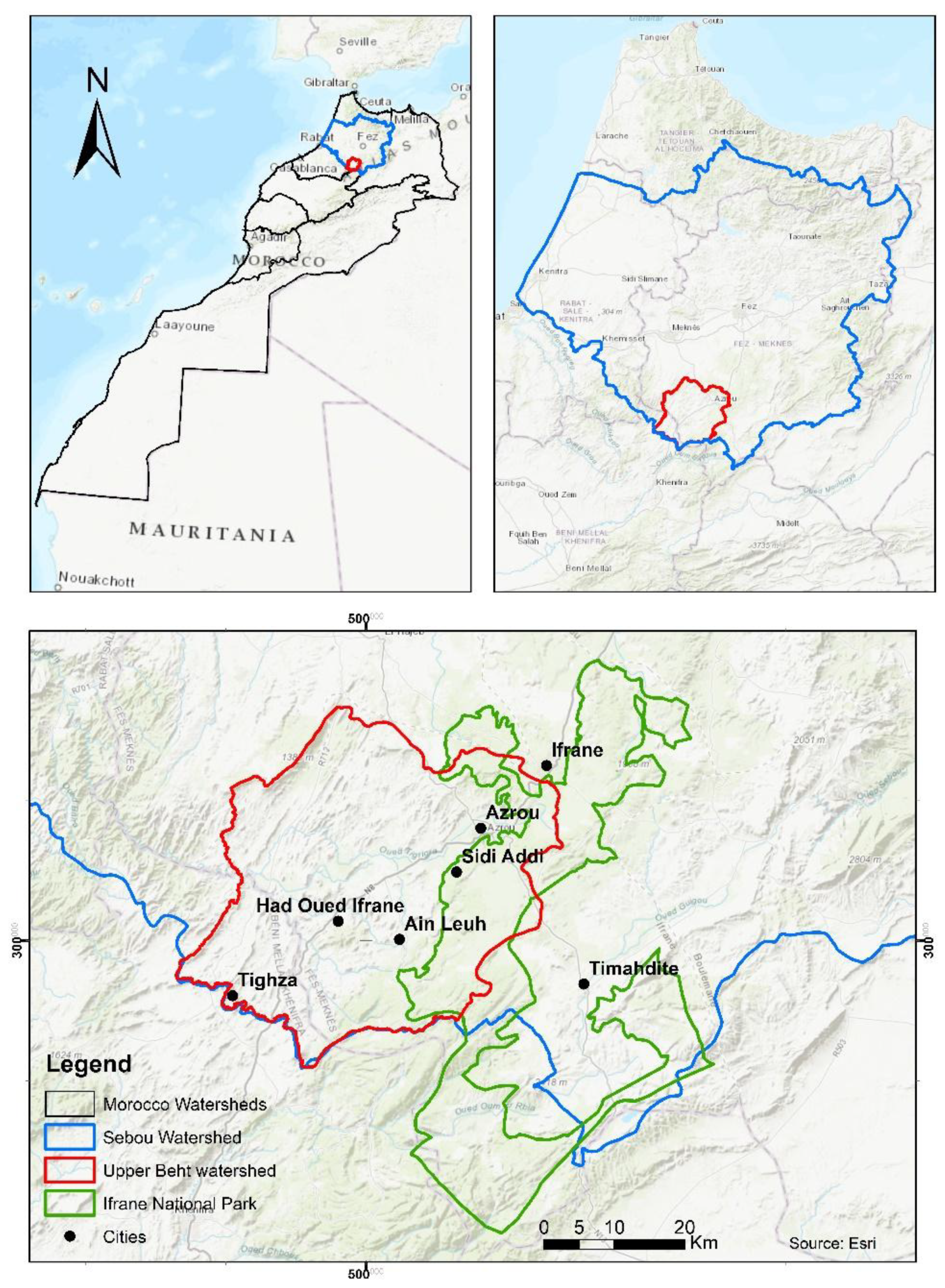
Figure 2.
LULCC within the INP watershed: (a) and (b) represent the period before park establishment, while (c) and (d) illustrate the period after park establishment.
Figure 2.
LULCC within the INP watershed: (a) and (b) represent the period before park establishment, while (c) and (d) illustrate the period after park establishment.
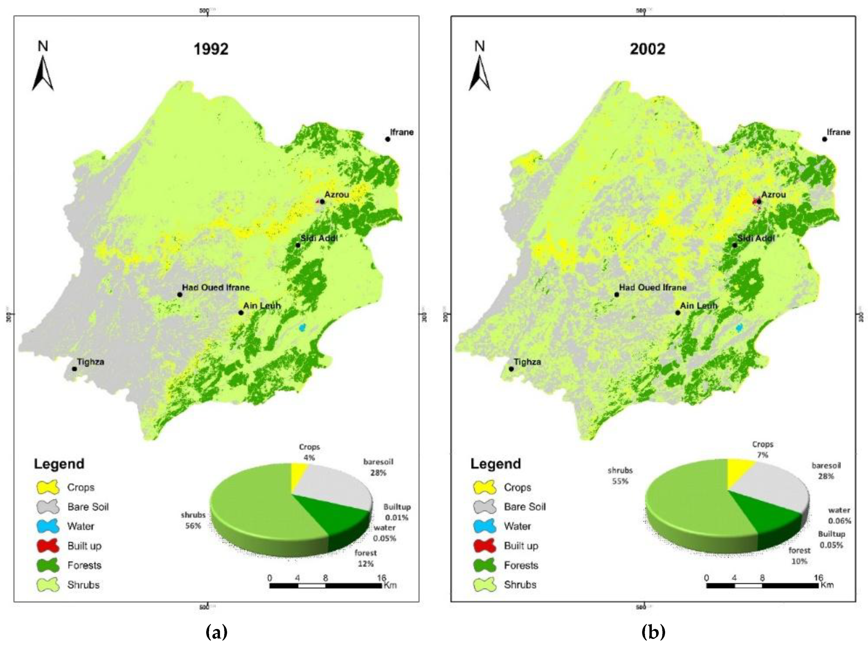
Figure 3.
Sediment losses within the INP watershed in tone per year.
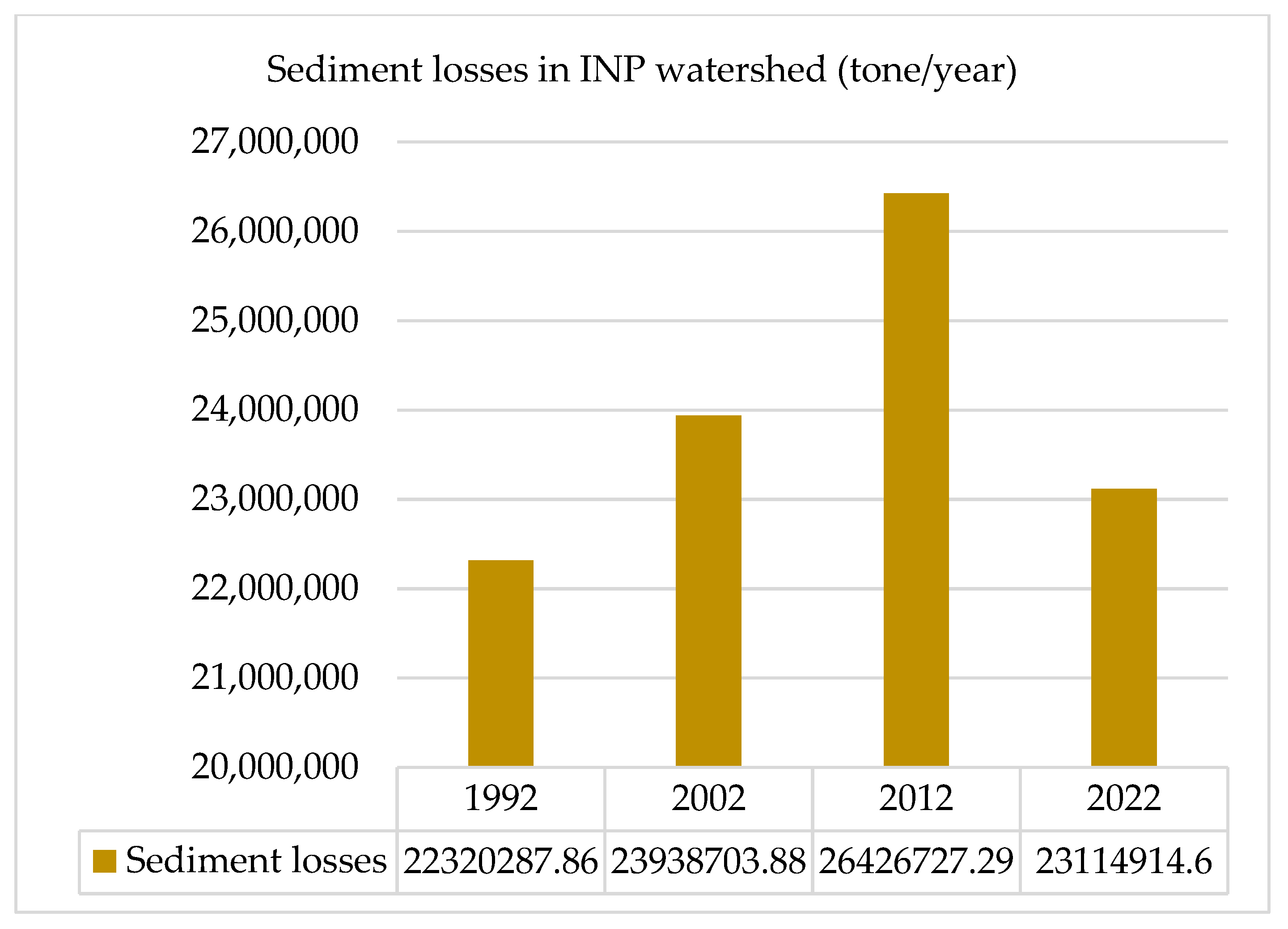
Figure 4.
Sediment losses maps within the INP watershed: (a) and (b) represent the period before park establishment, while (c) and (d) illustrate the period after park establishment.
Figure 4.
Sediment losses maps within the INP watershed: (a) and (b) represent the period before park establishment, while (c) and (d) illustrate the period after park establishment.
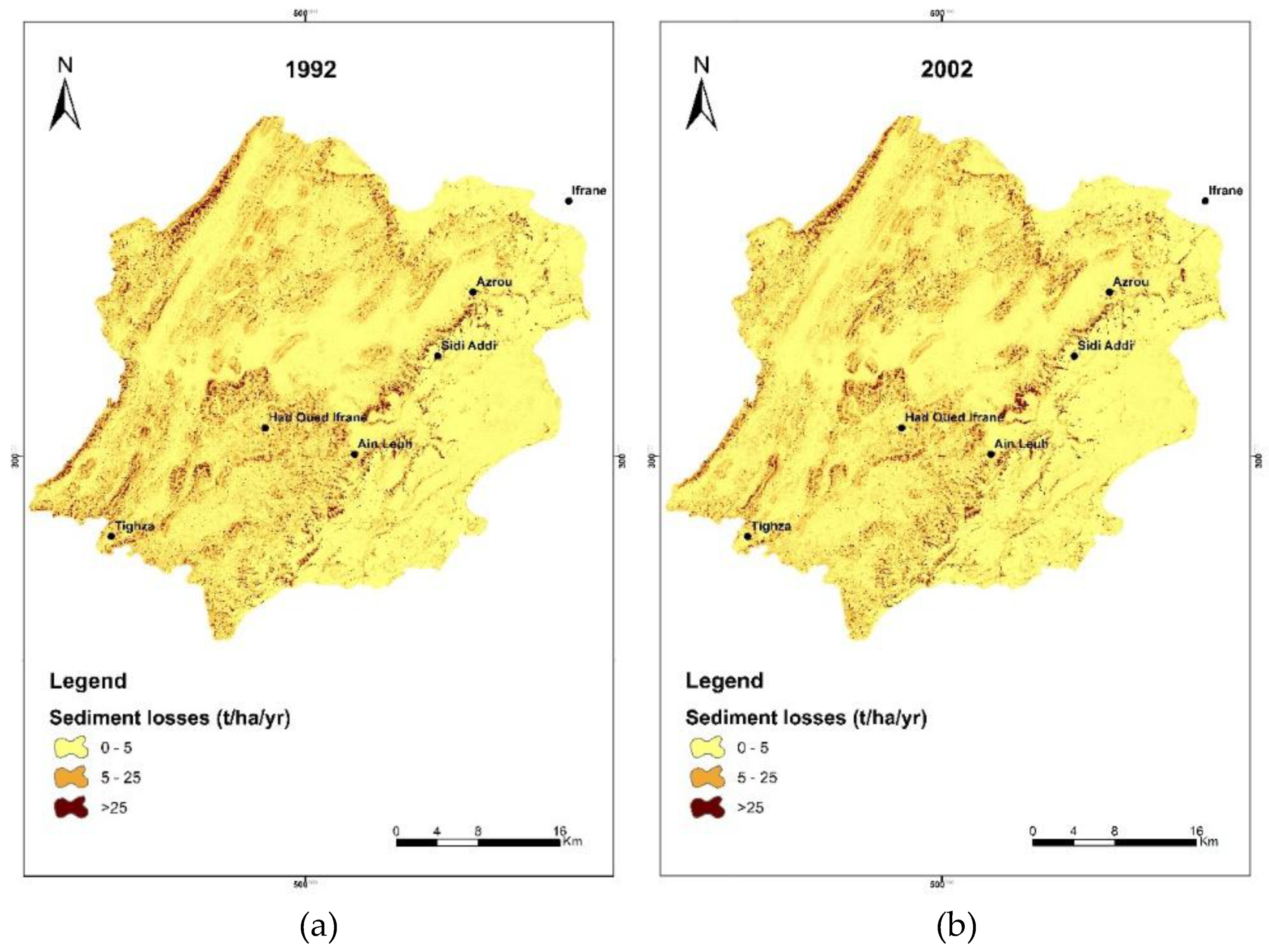
Figure 5.
Nitrogen and Phosphorus export in the INP watershed in kg per year.
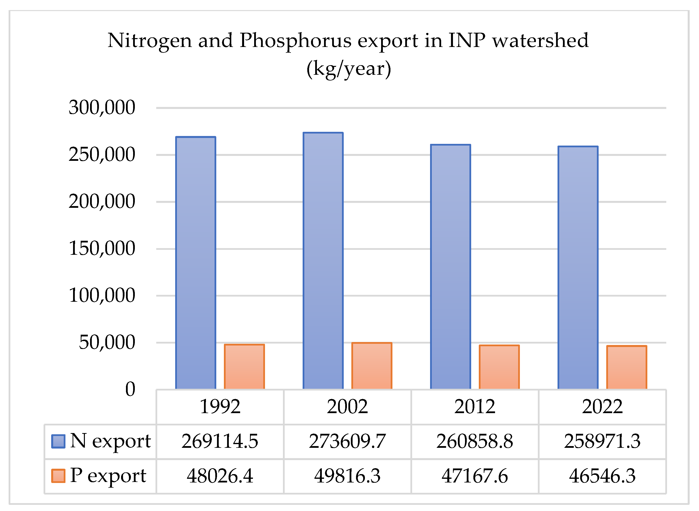
Figure 6.
Phosphorus export maps within the INP watershed: (a) and (b) represent the period before park establishment, while (c) and (d) illustrate the period after park establishment.
Figure 6.
Phosphorus export maps within the INP watershed: (a) and (b) represent the period before park establishment, while (c) and (d) illustrate the period after park establishment.
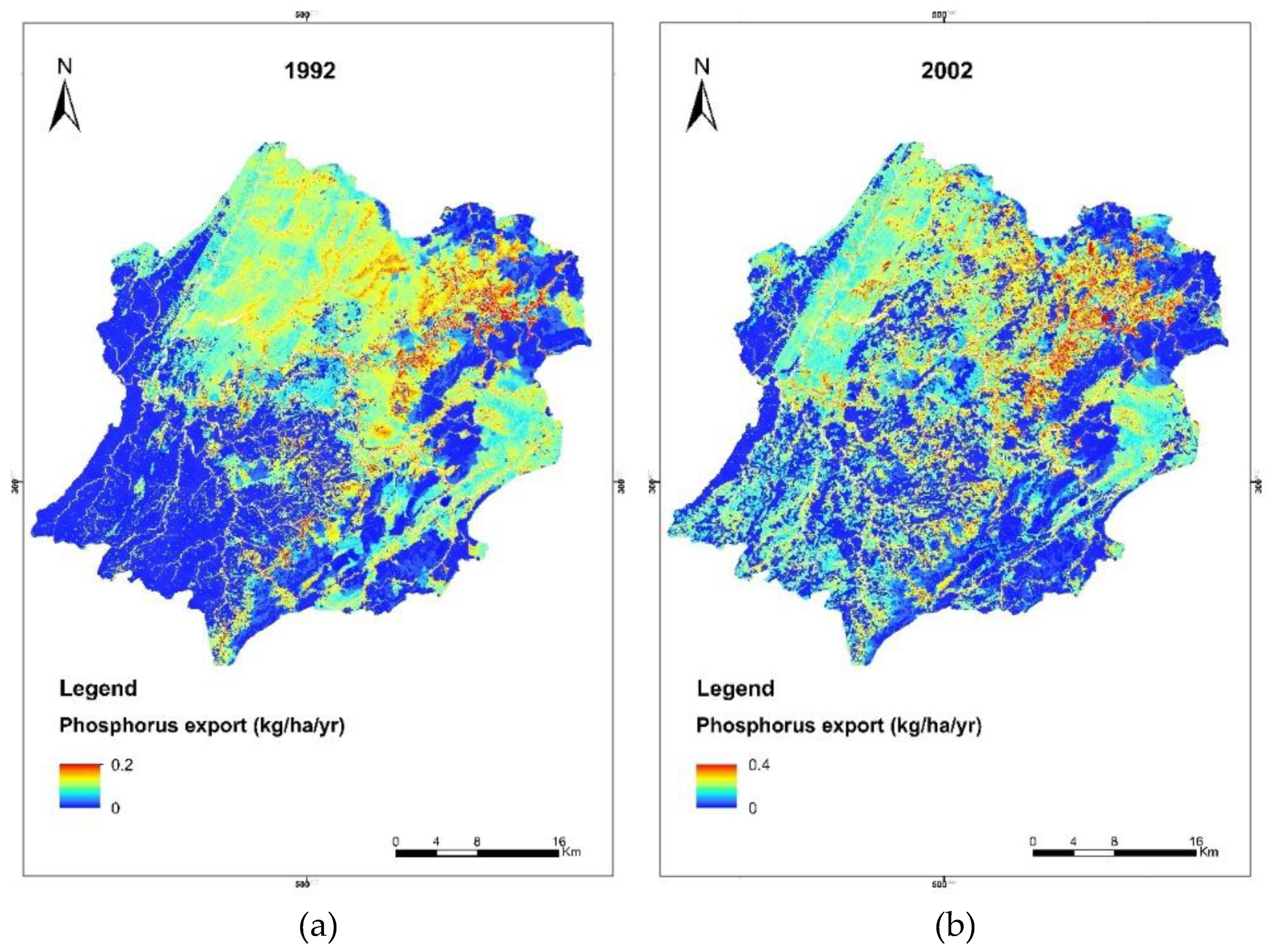
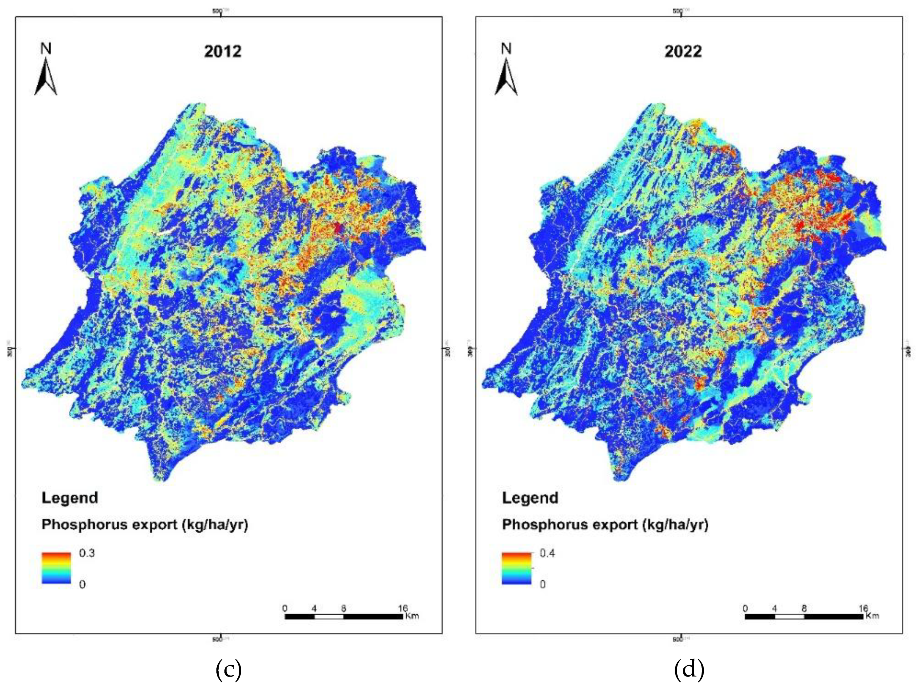
Figure 7.
Nitrogen export maps within the INP watershed: (a) and (b) represent the period before park establishment, while (c) and (d) illustrate the period after park establishment.
Figure 7.
Nitrogen export maps within the INP watershed: (a) and (b) represent the period before park establishment, while (c) and (d) illustrate the period after park establishment.
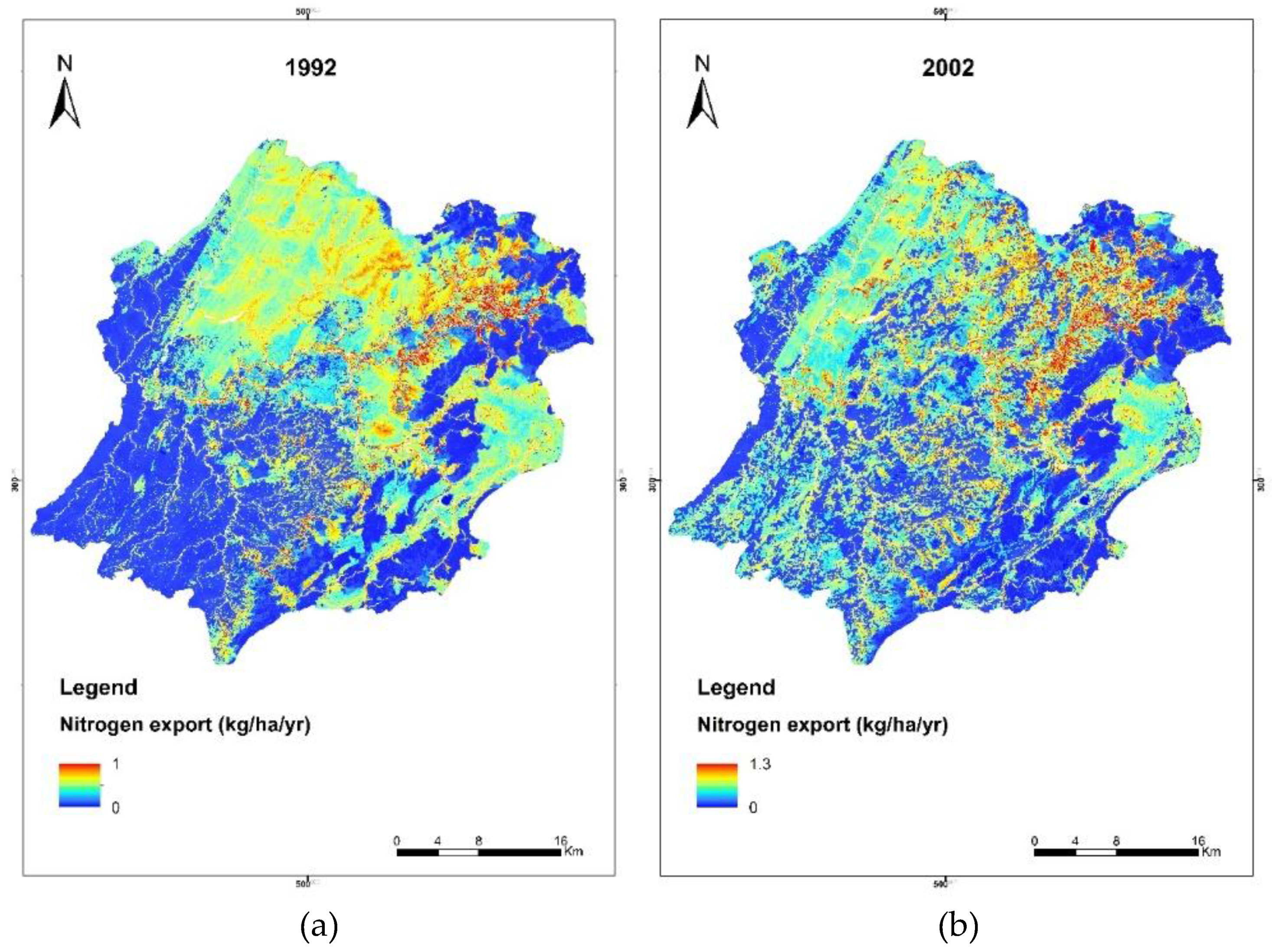
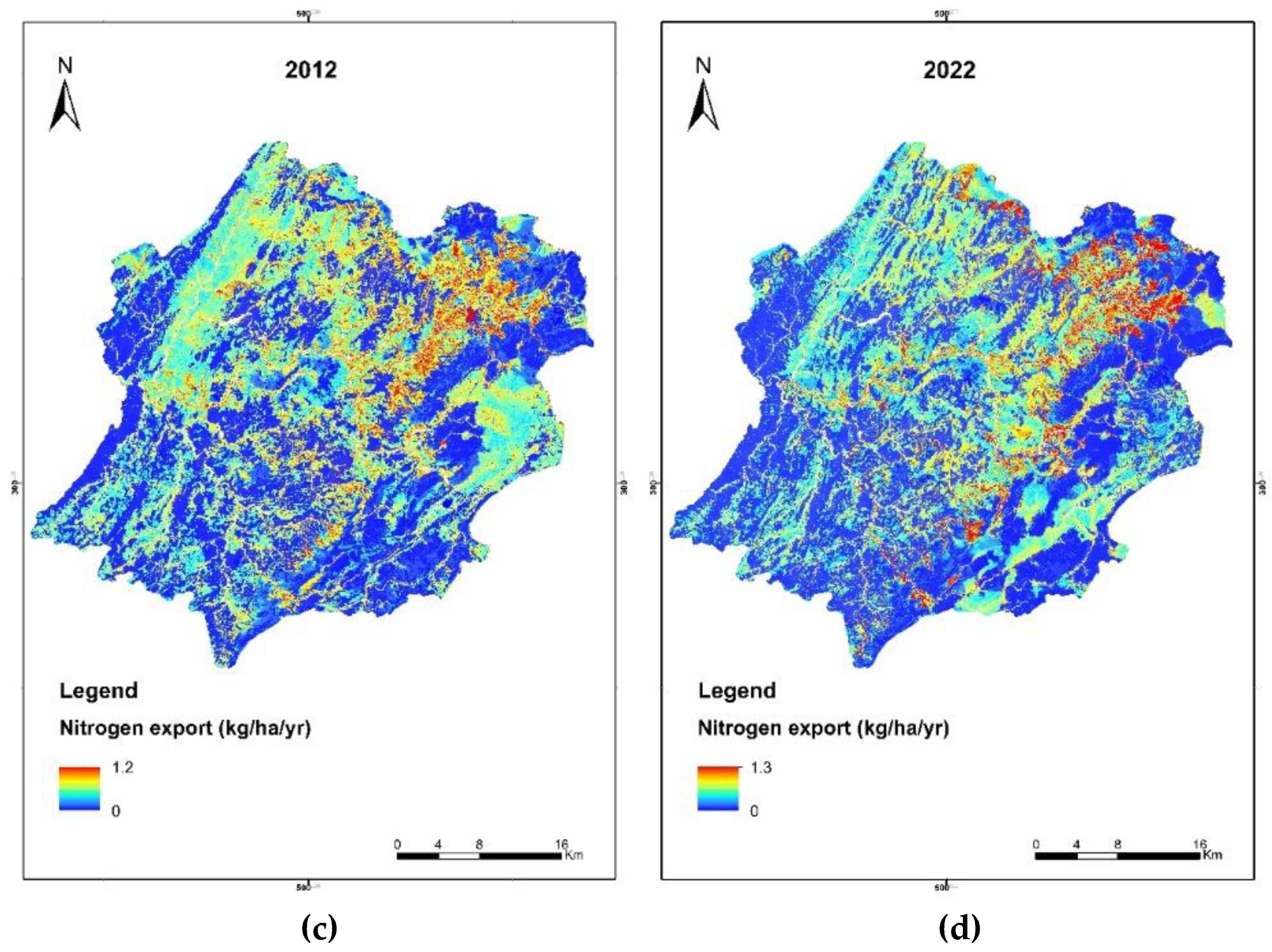
Figure 8.
Economic Value of WRES in USD per year.
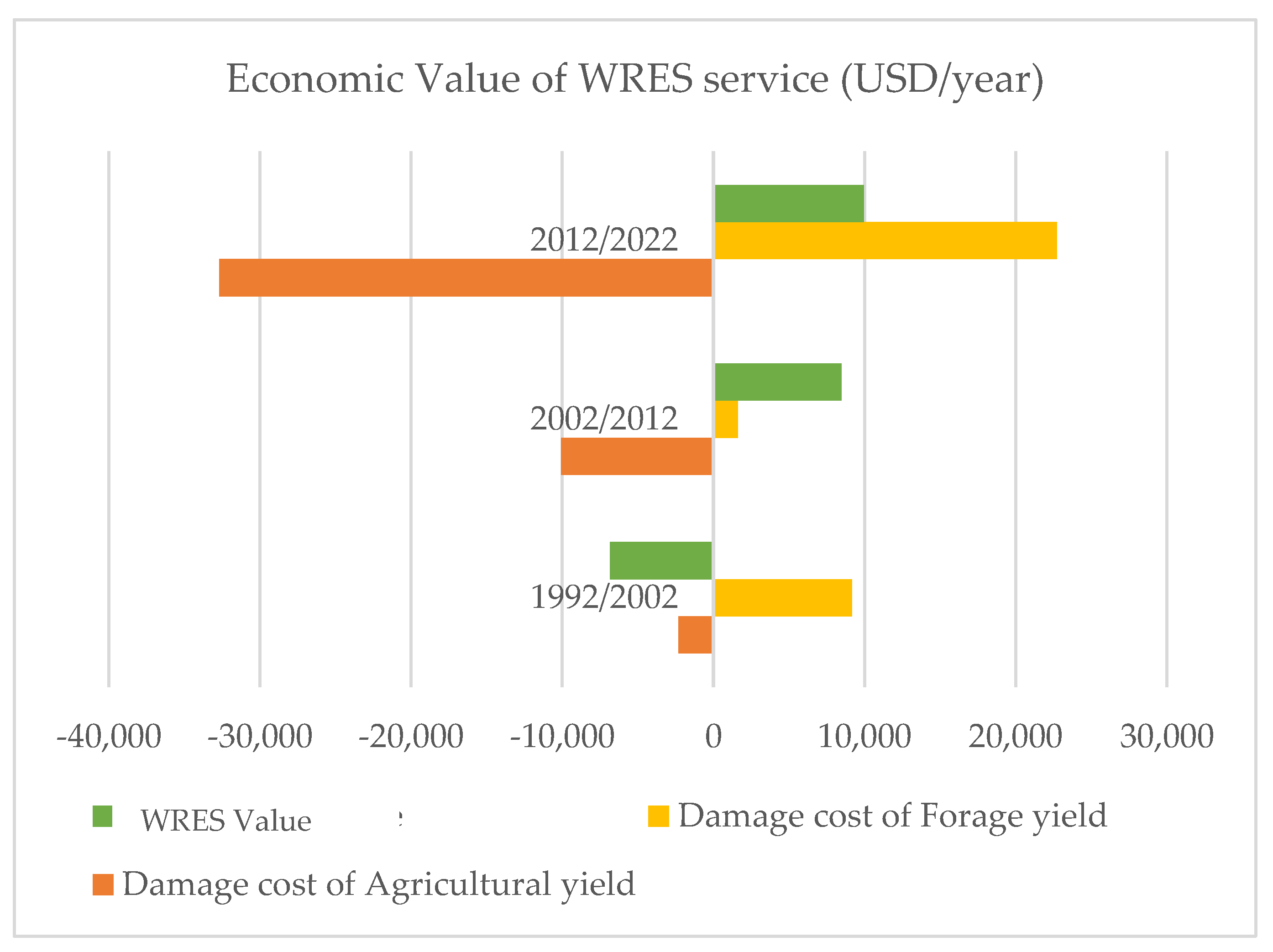
Table 1.
InVEST models data source.
| Models Inputs | InVEST Models | Source of Inputs |
| LULC | All InVEST models | Obtained using Google Earth Engine platform |
| Biophysical tables (*) | All InVEST models | From literature [31,32] |
| Rasters of precipitation | “Nutrient Delivery Ratio” |
Obtained from the website of CHIRPS: Rainfall Estimates from Rain Gauge and Satellite Observations, Climate Hazards Center (https://www.chc.ucsb.edu/data/chirps) accessed on 03/09/2024) [33] |
| Digital Elevation Model | “Sediment Delivery Ratio” “Nutrient Delivery Ratio” |
From the website of Earth Science Data Systems (ESDS) Program of the National Aeronautics and Space Administration of the United States of America (https://earthdata.nasa.gov (accessed on 15/08/2021) [34] |
| Erosivity raster (R Factor) |
“Sediment Delivery Ratio” | Calculated from annual and monthly precipitation averages over a 30-year period (1992–2022) Obtained from the website of CHIRPS, using the formula of Rango and Arnoldus (1987) [33,35] |
| Soil erodibility raster (K factor) |
From literature [31] |
(*)Appendix A.
Table 2.
Correspondence between forage productivity loss and level of soil degradation.
|
Erosion Classes (t/ha/year) |
Loss of Forage Productivity (%) |
| 0–5 | 2.5 |
| 5–25 | 25 |
| >25 | 45 |
Table 3.
Evolution of LULC class within the INP watershed (1992/2022).
| LU class | Surface in 1992 (Ha) | Surface in 2002 (Ha) | Surface in 2012 (Ha) | Surface in 2022 (Ha) |
| Crops | 6,999 | 11,762 | 12,456 | 18,502 |
| Bare soil | 47,150 | 46,535 | 54,074 | 58,242 |
| Water | 89 | 97 | 96 | 49 |
| Built-up | 14 | 79 | 106 | 976 |
| Forest | 19,564 | 17,592 | 16,058 | 20,476 |
| Shrubs | 95,365 | 93,116 | 86,391 | 70,936 |
| Total | 169,181 | 169,181 | 169,181 | 169,181 |
Table 4.
Kappa coefficient for the classifications.
| 1992 | 2002 | 2012 | 2022 | |
| Kappa coefficient | 89% | 91.3% | 93.8% | 98.14% |
Table 5.
Losses in agricultural yields as a function of soil losses.
| Soil Loss Class (t/ha/year) |
Erosion Rate Ewp (t/ha/year) |
Decrease in Yield: r (%) |
Decline in Yield ∆R = rxAverage Yield (2 t/Ha) (t/ha) |
Annual Cost 1992/2002 (USD/year) |
Annual Cost 2002/2012 (USD/year) |
Annual Cost 2012/2022 (USD/year) |
| 0–5 | 2.5 | 0.04 | 0.07 | 9255.9 | 1427 | 2219.8 |
| 5–25 | 15 | 0.31 | 0.06 | -81.6 | 177 | 501.6 |
| >25 | 25 | 0.59 | 0.12 | -6.8 | 8.6 | 46.9 |
| Total | 9167.6 | 1612.7 | 22741.4 |
Table 6.
Losses in forage yield as a function of soil losses.
|
Soil Losses (t/ha) |
Loss of Forage Productivity (%) |
Loss of Forage Productivity (UF/ha) |
Annual Cost (USD/year) |
Annual Cost (USD/year) |
Annual Cost (USD/year) |
| 0–5 | 2.5 | 3.3 | -902.1 | -6,284.8 | -20,784.5 |
| 5–25 | 25 | 32.9 | -1,307.4 | -3,618.6 | -10,803.3 |
| +25 | 45 | 59.3 | -104.7 | -179.8 | -1,122.9 |
| Total | -2314.2 | -10083.1 | -32710.8 |
Note: Negative values in the tables indicate a reduction in the cost of lost productivity, reflecting an improvement in WRES, while positive values indicate the opposite.
Disclaimer/Publisher’s Note: The statements, opinions and data contained in all publications are solely those of the individual author(s) and contributor(s) and not of MDPI and/or the editor(s). MDPI and/or the editor(s) disclaim responsibility for any injury to people or property resulting from any ideas, methods, instructions or products referred to in the content. |
© 2025 by the authors. Licensee MDPI, Basel, Switzerland. This article is an open access article distributed under the terms and conditions of the Creative Commons Attribution (CC BY) license (http://creativecommons.org/licenses/by/4.0/).
Copyright: This open access article is published under a Creative Commons CC BY 4.0 license, which permit the free download, distribution, and reuse, provided that the author and preprint are cited in any reuse.


