Submitted:
14 January 2025
Posted:
16 January 2025
You are already at the latest version
Abstract
Using the gold provinces in the northern margin of the North China Platform and the western Canadian orogenic belt—separated by thousands of miles—as examples, this article examines the temporal and spatial relationship between global gold deposits and geological structures; that is, gold metallogenic series within a region often correspond to the fault structural systems in that area. Fault structures at different hierarchical levels within the same fault system play distinct roles in gold deposit formation: the first-level deep and large faults are often the channels for the rise of rock-forming materials and their carriers, and control countless gold belts and/or gold fields on the earth's surface. The secondary fault system controls gold fields and/or gold deposits of different sizes. The third-level fault controls the gold ore body of a specific deposit. The mechanical properties of faults, their activity periods, and the development of structural rocks influence the timing and stages of mineralization, as well as the intensity and structure/texture of the resulting ore deposits. Post-ore-forming structures play a crucial role in converting primary gold deposits into placer gold deposits through processes such as uplift, displacement, transformation, and destruction of the original deposits. The deep-seated mechanisms underlying the structural control of gold mineralization align with principles of mathematics, physics, and chemistry. Nonlinear coherent effects within the far-from-equilibrium dissipative structures of fold-fault-ore-forming systems are significant. The localized dissipative structures resulting from tectonic and/or structural activity drive the final stages of gold mineralization. The essence of mineralization is the result of steady-state instability developing into a dissipative structure far away from equilibrium. The structures facilitate the conduction, extraction, further enrichment, and upward intrusion of deep ore-bearing fluids through special physical effects like seismic pumping, expansion, and re-fracture of mineralized zones. Deep and large faults also contribute to the formation of gold belts, ore fields, and deposits by inducing localized melting of rocks at different depths and mixing within the same tectonic system, as well as certain mutations in the ore-forming fluid entering the nonlinear low-pressure expansion zone, which causes hydrothermal boiling and a rapid nonlinear decrease in the solubility of the ore fluid. From a chemical perspective, the low-pressure expansion spaces formed by these structures act as vast mineralization reactors, in which rock-forming and mineralizing materials from different sources undergo violent physical and chemical reactions. This melting reactor not only greatly changes the temperature and pressure of the fluid, but also leads to drastic changes in many chemical conditions such as oxygen fugacity, pH, and electrolyte balance, thus creating conditions for the formation of gold deposits. Some structures, such as epigenetic faults, intersect and divide each other to create differences in the bottom topography, hydrodynamics, hydrogeochemistry, and physical chemistry in the basin. These variations create favorable space for the accumulation of large quantities of minerals, contributing to the formation of large or even super-large gold deposits.
Keywords:
tectonic and/or structural hierarchy system
; gold metallogenic series
; localized dissipative structure
; nonlinear coherence effects
; physical effects
; physicochemical differences
1. Introduction
The formation of gold deposits is subject to multivariate ore-controlling factors, including complex structural systems with different levels, various igneous rocks with multi-period and multi-cycle origins, and a vast stratigraphic space with different physical and chemical properties following long periods of sedimentation. These ore-controlling factors can either provide migration channels for ore-forming materials and their carriers, are themselves the sources of ore-forming materials, provide the necessary physical and chemical conditions for the enrichment of ore-forming materials, or ultimately provide storage space for the precipitation and placement of ore-forming materials.
Among the three major metallogenic geological conditions mentioned above, structure, especially faults, is undoubtedly the most eye-catching, and to some extent, the most important. With various levels and different mechanical properties of faults, rock-forming and mineralizing materials such as igneous rocks occur, differentiate, and evolve, form ore-bearing fluids, and enrich to eventually form mineral deposits [1,2,3].
Therefore, summarizing and discussing the temporal and spatial distribution patterns and genetic relationships between structure and gold mineralization, especially the deep-seated mutual achievement mechanism between the two, has very important significance to both theoretical and practical mining. After all, the formation of a considerable proportion of hard rock gold, especially endogenous gold deposits, is closely related to structure. The survey, exploration, and development of gold deposits are also inseparable from the in-depth study and understanding of structure.
The authors’ research, exploration, and development experience in the early Precambrian blocks and volcanic basins of the major gold provinces in the North China Platform, including Hebei, Liaoning, Henan and Shandong, in addition to gold deposits in the Mesozoic orogenic belt of western Canada, is combined with relevant research results of other scholars. This paper summarizes the close temporal, spatial, and causal connection between gold mineralization and structure, and explores the deep-seated intrinsic relationship between the two from the perspectives of mathematics, physics, and chemistry.
2. Examples of the Relationship Between Structure and Gold Mineralization
Although no two hard rock gold deposits in the world are exactly the same, almost all endogenous gold deposits around the world still have many commonalities. For example, the formation of these gold deposits is inseparable from the control and/or contribution of various geological structures. Below, we will take some typical gold provinces in China and Canada, thousands of miles apart, as examples to explain the close temporal and spatial relationship between structure and gold mineralization, so as to provide geological facts for the discussion of the internal mechanism of structure control and contribution to gold mineralization later in this article.
2.1. The Gold Province in the Northern Margin of North China Platform
In the thousands of years of Chinese civilization, Hebei Province, where the North China Platform is located, and its surrounding provinces of Liaoning, Inner Mongolia, Shanxi, Henan and Shandong, have always been important gold-producing areas for successive Chinese dynasties. Historically the focus was mainly the development and utilization of extremely high-grade placer gold deposits. Among them, Hebei Province is a typical representative. Take as an example Zhangjiakou gold province in Hebei Province, which is located on the northern edge of the North China Platform. This area still has a large number of gold deposits of different sizes, and gold mining sites are scattered and numerous (Figure 1). Zhangjiakou gold province is located in the convergent part between the Inner Mongolian axis (anticline) and the Yanshan geosyncline folded belt of the North China Platform. Most of the over 100 lode gold deposits in the region are located within a 1,500 square kilometer triangular area among the towns of Xuanhua, Chicheng, and Chongli, and are thus called a gold triangle (Figure 2 and Figure 3) [1,4,5,6,7]. The emergence of these gold deposits is closely related to the extremely developed faults and folds of different levels in the local area. Together with many gold deposits in eastern Hebei, Inner Mongolia, and western Liaoning, they are confined between and on both sides of two giant east-west fault tectonic zones on the northern edge of the North China Platform (Figure 1,Figure 2,Figure 3). Among the numerous gold deposits in the area, the largest and most representative are the Xiaoyingpan, Dongping, and Zhangquanzhuang gold deposits [5,6,7,8,9,10,11], followed by the Hougou, Shuijingtun, and Hanjiagou gold deposits (Figure 2) [5,6,7,8,9,10,11,12,13,14,15]. The Xiaoyingpan, Dongping and Zhangquanzhuang gold deposits also represent three different types of gold mineralization [5,6].
2.1.1. Regional Structure
Zhangjiakou has a long geological history and complex geological structure. The Archean Sanggan Group metamorphic rocks have undergone multiple stages of tectonic action, forming different types and forms of geological structures (Figure 3) [1,2,3].
Regional folds: The metamorphic rocks of the Sanggan Group underwent three folding deformations in the Early Precambrian [1,4]. The first phase of folding formed a giant compound syncline in the metamorphic rocks of the Sanggan Group, with an axis nearly east-west, an axis plane dipping south, and strata reversed from south to north, forming the basic structural framework of the Zhangjiakou area. Most researchers believe that this phase of folding occurred in the Archean, contemporaneous with the high-amphibolite-granulite metamorphic event in the region, and slightly earlier than the occurrence of the Chongli-Chicheng deep fault. The second-stage folds are a group of NW-NWW-trending, compound inverted anticlines, with axial planes inclined to the northeast or even lying flat. The sizes of the folds in this stage vary. The secondary tight folds with a scale of 10-100 m on both sides of the main anticline are extremely developed. The second-stage folds predate the migmatization of the area, which occurred at 2500-2400 Ma. The third-stage folds are a group of axially northwest or northwest-west-oriented compound folds formed by NE-SW compressional stress, which appear as wavy fold bundles widely distributed throughout the area, either parallel to each other or arranged in a staggered pattern. Their sizes vary, and a single anticline generally extends for 2-7 km. Among them, the backbone fold in this area is also the largest with the Hanjiagou anticline, which extends nearly 20 km along the axial direction (Figure 4). The Hanjiagou anticline is a wide and gentle wavy fold with a dip angle of about 30 degrees on both wings. The wavelength is generally several times greater than the wave height, and the axial plane is nearly vertical. It is one of the most clearly exposed and best preserved fold structures in the area.
Regional faults: There are many faults and/or fault zones in the area, which can be divided into east-west faults, northwest faults and northeast faults according to their strike direction (Figure 1,Figure 2,Figure 3). The gold belt and ore fields are mainly controlled by the east-west Chongli-Chicheng deep fault, and the gold deposits and ore bodies are located in the secondary fault systems on both sides of the deep fault. The intersection of faults in different directions is often where gold deposits are concentrated. This is also one of the common characteristics of almost all endogenous gold deposits in the world.
East-West fault: The Chongli-Chicheng deep fault zone, which is more than 500 kilometers long and 1-5 kilometers wide, is the most important first-order fault and gold-controlling structural zone in the North China Platform. As the dividing line between the Inner Mongolia axis and the Yanshan platform folded belt, the fault zone starts through Shangyi, Shizuizi, Chongli, Zhenningbao to Chicheng in the west and turns north through Chengde and Beipiao to merge with the Kangbao-Weichang-Chifeng fault zone, forming an important gold metallogenic zone in northeastern China. The fault zone is composed of a series of densely parallel high-angle reverse faults, compression and crushing zones, and ductile shear zones. The rock strata close to the fault zone are nearly upright and some small mylonite belts are developed along the layers. The fault surface is roughly south-dipping, and the alteration foliation on both sides is strong. The rocks in the fault zone generally contain 0.01-0.40 g/t of gold, with the highest at 0.87 g/t [1]. There are a series of Archean and Hercynian basic-ultrabasic rock bodies of varying sizes on both sides of the fault zone. Gravity field measurements have shown that the fault zone cuts deep below the Moho surface. The depth of the Moho surface in the Chongli area is 42-43 km [1,4,8]. This is a deep fault zone that has been active from the Archean Era through the Himalayan Period. The series of structures derived from it not only control a series of magmatic activities, but also control deformation, metamorphism, migmatization, and sedimentation of different ages and scales on both sides. All these geological processes provide power, heat, mineralizing materials, ore fluid migration channels, and ore-bearing space for the activation, migration, and enrichment of gold in this area, and ultimately create many different types of gold deposits in the Zhangjiakou gold province (Figure 5). On both sides of this fault zone stretching for more than 200 km, especially within 30 km on its south side, from the Erdaobei gold mine in Shangyi in the west to the Tulongshan gold mine in Chicheng in the east, there are more than 100 gold deposits and gold showings distributed intermittently (Figure 1 and Figure 2).
The fault zone is mainly composed of early mylonite rocks, late tectonic breccias, marine sedimentary rocks of the lower part of the Mesoproterozoic Changcheng Group, and tectonic rocks of the Jurassic. Some sections are limonite-mineralized, and thin quartz veins are interspersed and filled along the fault zone. The mylonite is mainly composed of sericite, light red potassium feldspar, and quartz, the latter possessing an obvious wire drawing structure. These rocks with strong tectonic foliation are often distributed around some rigid blocks. The structure and rock deformation of the fault zone indicate that it has a history of multi-period and multi-stage activities [1,4,7,8,9,10,11]. Its main activity periods are: the early stage, including the ductile shear thrust during the Late Archean Wutai Movement; the middle stage of the Proterozoic Jixian Movement, was revived and dominated by ductile-brittle thrust activities; the Hercynian stage, characterized by brittle deformation and the formation of a large number of tectonic breccias, accompanied by the emplacement of basic and ultrabasic rock bodies. Finally, the late stage, comprised of the Mesozoic and Cenozoic periods, was characterized by brittle normal fault activities.
- NW-trending fault: The northwest-trending faults are the most widely distributed, large-scale, and frequently active group of faults in the area. According to the occurrence, they can be divided into two groups: one group strikes NW310°-340°, dips to the northeast, and has a dip angle of 50°-80°. It is mainly distributed in the Zhangquanzhuang-Xiangshuigou area, containing many gold-bearing quartz veins and filled with various igneous dykes. The other group strikes NWW280°-310°, dips to the south, and has a dip angle of 60°-70°, which is mostly consistent with the occurrence of the strata. The faults are filled with gold-bearing quartz veins with very few igneous dykes. It is mainly distributed in the Shuijingtun-Sitaizui area. In the Xiaoyingpan-Zhangquanzhuang area, more than 200 gold-bearing quartz veins and intermediate-basic dykes distributed in the northwest are widely developed. This fact shows that the northwest-west-trending faults in the area have important mineralization and prospecting significance. The northwest-trending faults that are closely related to mineralization have the following characteristics: larger-scale faults often show traces of multi-stage activities, and the structures are inherited and accompanied by multi-stage hydrothermal superposition. Before gold mineralization, they were characterized by compression and torsion, and during the mineralization period, they were tensile and tension-torsion. The deposits and ore bodies are often controlled by secondary feather-shaped fissures. The various types of igneous dykes contained within them, including gabbro, diabase, lamprophyre, diorite porphyry, granite porphyry, and quartz porphyry, are mostly very developed due to the influence of later structures, and polymetallic mineralization is common. The top and bottom plates and surrounding rock of the fault are well hydrothermally altered, and sericitization, silicification, chloritization, and pyritization are common.
- North-South fault: According to their formation age and structural characteristics, the North-South fault can be divided into two categories: one is a large-scale multi-stage active fault, extending 3-7 km; the fracture zone constituting the fault is relatively wide at 20-30 m on average, with the widest area at 50-100 meters with an inclination of 50°-70°. It is filled with gold-bearing quartz veins or dykes and has developed various alterations, which were revived in the Yanshan orogeny and destroyed the existing ore bodies and/or cut through the dykes. The second category is the product of the Yanshan orogeny, with a small scale and obviously cuts various early geological bodies and ore bodies.
There are many ductile thrust structures and a klippe group in the area, some of which are closely related to the formation of gold deposits. For example, the main controlling ore structure of the Xiaoyingpan gold deposit discussed below is a typical representative of this type of ductile thrust structure.
2.1.2. Ore-Bearing Structure
The main ore-bearing structure of Xiaoyingpan gold deposit is a gentle wavy compression-shear structure, with an overall trend of 46° northeast, a dip to the southeast, and an average dip of 4° (Figure 6). The gently dipping gold-bearing quartz vein, i.e. the fault, is bounded by different lithologies of the hanging and foot walls: the hanging wall is composed of the older Archean Huajiaying Formation metamorphic rocks (Arh), while the footwall belongs to the younger Jiangouhe Formation metamorphic rocks (Arj). Most researchers theorized that [4,7,8,9,10,11,12] this structure is an interlayer sliding or detachment zone. It is a compressive structure formed by relative sliding between the metamorphic rock layers of the Huajiaying Formation and Jiangouhe Formation of the Archean Sanggan Group during the compression and folding process. It was later filled with gold-bearing ore fluid to form the main ore body of the Xiaoyingpan gold deposit.
Field observations and studies have shown that the structure is mainly composed of mylonite rocks and is strongly altered, and the gold-bearing quartz veins are strictly confined within the mining area. The more than 30 gold-bearing quartz veins exposed on the surface that were originally identified were later proven to belong to the same vein belt through systematic exploration and were strictly controlled by the uneven compressional structure with convex and concave separations. After a detailed field study of this ore-bearing structure, the author of this article concluded that it is not an interlayer sliding zone or a slip zone, but a typical thrust-nappe ductile shear zone. The evidence is as follows: The overall occurrence of this large-scale gently inclined quartz vein-type ore body is not consistent with the overall occurrence of the gneissosity of the metamorphic rock strata in the mining area, nor is it consistent with the trend of the folds in the area. No matter what kind of superposition the folds developed in the area have experienced, their trends are all NW, EW, and SN, and there are no NE-trending folds. The overall occurrence of the main ore body of the Xiaoyingpan gold deposit strikes 46 degrees north and dips to the southeast. Obviously, it is impossible for the existing fold structure to form such an occurrence of the ore body through interlayer sliding. Statistics of more than 500 occurrences of ore bodies in different parts of the mining area show that the dip angle of the ore body is generally 3°-5°, and locally 17°-21°. Statistics on the occurrence of the strata above and below the ore bodies in the area show that the strata in the mining area generally have an inclination of 20°-40° and can reach 50°-60° or even steeper locally. Obviously, the ore bodies and strata are in an oblique relationship, which is also proved by field observations. This oblique relationship cannot be explained by the view of interlayer sliding (debonding) zones.
It is almost universally recognized by relevant researchers that the turning end of a fold is often a favorable location for mineralization. This favorable location includes two main parts: the collapsed location and the compression cracks, especially the tension cracks. If the main mineralization structure of the Xiaoyingpan gold deposit is indeed a slip structure in the process of folding, then there should be ore bodies filled in the collapsed location and/or structural cracks at the turning end, but neither drilling nor open pit exploration have found the existence of such ore bodies. This proves instead that the mineralization structure is not an interlayer slip structure in the process of folding. Field drilling and open pit exploration also confirm the uneven mineralization structure, with a height difference of 20-30 m between the ore layers at the crest and trough and a wavelength difference of about 100 m, while the ore body is still continuous in the same layer [1,4]. It is hard to imagine that the ore-bearing space created by the interlayer sliding (decollement) during the folding process can create such a huge single ore body. As previously mentioned, the hanging and foot walls’ lithology of the ore-bearing quartz veins is different, and the secondary small soft wrinkles and fold structures are developed in the metamorphic rocks of the hanging wall but not in the foot wall (Figure 6). If the structure where the ore body is located is indeed the interlayer sliding (decollement) between Arh and Arj, then the ore body should only be produced in this position. The reality is that this structure is only the location where the main ore body of the mining area is located. The gold ore body is not only produced in the contact zone between the Huajiaying Formation of the Sanggan Group and the Jiangouhe Formation metamorphic rocks, but are also produced in single Arh or Arj metamorphic rocks. This obviously cannot be explained by the interlayer sliding (decollement) structure between Arh and Arj to explain its ore-control mechanism.
Some researchers believe that the ore-bearing structure of the Xiaoyingpan gold deposit is part of the Qingbiankou-Xiaoyingpan thrust structure [13]. The two wings of this ductile thrust-nappe structure are tightly closed and small folds and secondary faults with inclined or upright axial surfaces are well developed, resulting in an intense deformation zone. A series of isoclinal inverted folds are developed in the middle zone between the root and the frontal zones. The axial surfaces of these folds are inclined to the root zone, and secondary faults are developed. The thrust-nappe structure is a rear-edge thrust fault system that is imbricate fan-shaped and has forward extension characteristics. . Blastomylonites are developed in the Dongwangshan-Zhoudingtun-Geyubao area , which are the product of early ductile thrust deformation and later transformation such as static recrystallization. Its external system is the Archean granulite facies terrane, which is a component of the early deeper crust that was exposed to the surface through thrust uplift. Its scale is estimated to be more than 100 km, and the thrust distance may be several kilometers. This thrust structure has the characteristics of multiple periods of activity, and it may be revived in the later period [14,15,16,17].
Thrust faults are well developed in the Huajiaying Formation (Arh), the main ore body’s hanging wall in the Xiaoyingpan gold deposit. As secondary structures of the hanging wall, these thrust faults are either oblique to the surrounding rock or occur along the layer and become interlayer faults. In this regard, the main ore-bearing structure of the area cannot be consistent or parallel to the occurrence of the surrounding rock, otherwise its secondary faults will not occur along the layer. This proves from one aspect that the main ore-bearing structure is not what has previously been called an interlayer sliding. Both these small-scale thrust faults and the main ore body are upturned about 25° north, and the occurrence gradually slows down towards the south. In the Sandaogou open-pit mining area of the Xiaoyingpan deposit, you can see almost vertical strata and ore-bearing layers upturned to the north. This shows that the overall movement direction of the thrust structure is from south to north. The remaining scratches, steps, and directional mylonite structures on the hillside to the west of the Sandaogou mining area also confirm this.
Mylonite is widely developed in both the hanging and foot walls of the ore-bearing structure in the Xiaoyingpan West mining area, especially in the foot wall. This indicates that the thrust nappe structure is a ductile shear zone. There is also sugar-like quartz with slight iron staining and yellow-brown and brown in the mining area, and the quartz grains are of different sizes. According to Bonnemaison and Houssou et al [18,19], this kind of extremely fine, milky white or even colorless and transparent sugar granular quartz, which sometimes has a jasper- or chalcedony-like appearance, is composed of microcrystalline quartz (1 - n μm) aggregates. This microcrystalline quartz aggregate is the result of the reprecipitation of silicon dioxide after the original existing mineral-free milky white quartz formed a solution through mylonitization. Essentially, the mineral-free quartz vein plays the role of sugar granular quartz matrix. Sugar granular quartz is a "lithology" that is conducive to capturing gold and is the result of ductile shear. In other words, sugar granular quartz can be used as an identification mark for the existence of ductile shear zones.
In summary, the ore-bearing structure of the Xiaoyingpan gold deposit is a gently inclined, thrust-nappe ductile shear zone. The general direction of the thrust is from south to north. From a regional perspective, along with the aforementioned first-stage closed isoclinal folds, a series of thrust-nappe ductile shear zones developed in the Zhangjiakou area. In addition to the above-mentioned Xiaoyingpan main ore-bearing and Chongli-Chicheng giant thrust-nappe ductile shear zones, there are also the Shizuizi-Xishuangtai and Dalingbao-Tianjiayao thrust-nappe structures. In this geological environment where thrust-nappe action is generally developed, the possibility of the development of thrust-nappe ductile shear zones in the Xiaoyingpan area is far greater than interlayer sliding.
Based on the interaction between different geological phenomena in the field and the characteristics of the Xiaoyingpan gold deposit’s main ore-bearing structure, and by comparing them with faults at different stages in the region while accounting for the isotopic ages of existing geological events (Table 1), it should be effective to examine the formation age and development evolution of the ore-bearing structure.
Through a detailed study of the Xiaoyingpan gold deposit and regional structures, some researchers have concluded that its main controlling structure is one of a series of faults that occurred with the first phase of folding. In other words, the ore-bearing structure of the deposit occurred during the Wutai Movement at the end of the Archean Era [37,38]. Judging from the deformation characteristics of the ore-bearing structure and its hanging rock strata, it is similar to the Chongli-Chicheng giant thrust nappe ductile shear zone. Therefore, the author agrees with this view. Judging from the different fillings in the fault zone, this is also a multi-stage active fault zone. The fault has since been reactivated, and the gold-bearing quartz veins have been strongly broken and transformed.
The main ore-bearing structure of the Xiaoyingpan gold deposit is a fault that occurred in the late Archean and was active many times across different geological periods. The three main evolutionary stages of the fault and their characteristics are as follows: ① Early ductile deformation began in the late Archean, and thus the characteristic mylonite is formed. The rock is transformed from high amphibolite phase to granulite phase through ductile shearing to greenschist phase. The typical mineral combination is sericite + chlorite + quartz ± feldspar. ② The mid-term brittle-ductile or ductile-brittle deformation stage occurred in the Hercynian period. Uneven strain occurred in the area due to the differences in the rock types that underwent tectonic activation in different sections, some of which were continuous non-uniform strains while others were discontinuous non-uniform strains. In this way, hardening occurred through plastic deformation in some sections, where the rock’s mechanical properties changed from toughness (plasticity or viscosity) to brittleness. This caused the ductile shear zones formed under the same time, space, and physical and chemical conditions to show different characteristics of toughness or brittleness in different sections. Fractures in brittle sections lead to the filling of quartz veins, or the pre-existing quartz veins are fractured and gold-bearing hydrothermal fluids flow in to form quartz vein-type ore bodies. In the ductile stage or section, sugar-like gold-bearing quartz veins and altered rock-type gold mineralization are formed. This also explains why there are two types of gold ores in the Xiaoyingpan deposit. ③The late transformation that occurred in the early Yanshan orogeny was brittle deformation, which was mainly manifested in the strong crushing and transformation of the existing ore body, causing dislocation and complicating its occurrence. At the same time, white quartz and carbonate veins without ore were generated. This post-ore-forming transformation stage created good conditions for the late oxidation and secondary enrichment of the ore in the mining area, and also created conditions for the formation of local placer gold deposits.
In summary, the main ore-bearing structure of the Xiaoyingpan gold deposit has multi-stage and multi-phase activity characteristics and exhibits different structural properties. This structural feature leads to multi-stage and multi-phase gold mineralization, as well as different mineralization styles, namely quartz vein, replacement, and oxidized secondary enrichment.
2.2. Gold Deposits and Structures in the Mesozoic Orogenic Belt on the West Coast of Canada
The Cariboo gold mining district (Figure 9), located in the east-central region of British Columbia, Canada, has been a historically significant gold rush district on the Pacific coast of western North America since at least Large-scale gold rush mining occurred in this region prior to the 1930s, since which exploration and mining of hard rock gold have been the main focus. To this day, it is still an important gold-producing area in North America with hard rock gold as the main exploration and mining target. At the same time, placer gold mining of different scales still flourishes. During the Great Depression in the 1920s, the Cariboo gold mining district thrived in spite of the broader severe economic decline. The British Columbia government even had plans to move the provincial government to Barkerville, a small town that was the epicenter of the Cariboo gold mining district. Although this move did not come to fruition, Barkerville, which is still famous for its role in the BC gold rush, has become a provincial park and is still favored by tourists from all over the world. Among the many projects in the park, the most popular one is the gold panning show. The luckiest tourists will harvest a small amount of real gold nuggets among the “fool’s gold” pyrite that was put in the sediment beforehand.
According to relevant statistics, recorded gold production from the Cariboo gold mining district totals some 5.0 million ounces, including an estimated 3.0 million ounces from placer mining from 101 creeks and rivers, and 2.0 million ounces from lode gold mining [41,42].
The mining district lies approximately 80 km east of Quesnel, 120 km southeast of Prince George, and 500 km north of Vancouver. It is situated within the Quesnel Highlands on the eastern edge of the Interior Plateau (Figure 9). The highlands have an average width and length of approximately 50 km and 160 km respectively [43,44]. The Quesnel Highlands are the remnants of a rolling plateau formed initially from bedrocks lain down as the ancient North American Plate moved westwards, colliding with offshore seabed and island groups. The bedrocks were then overlain by lava flows emanating from Chilcotin volcanoes that filled the lowlands between the Coast and Cariboo Mountains. These remnants rise gradually from roughly 1,500 m above sea level in the west to more than 1,900 m above sea level in the east, and become progressively more dissected with elevation. Located between the Coast and northern Rocky Mountains, the district is within the Southern Cordillera region, as defined by the Geological Survey of Canada for the purpose of describing seismic risk [45,46,47].
Situated within the Cariboo gold belt (Figure 10), the district encompasses (from northwest to southeast) the former producing Hardscrabble tungsten-gold mine and the Mosquito Creek (MGM), Aurum, and Island Mountain gold mines (IGM), located on the northwest of the Jack of Clubs Lake. The IGM (1934-1967) and MGM (1980-1983) produced 603,800 ounces of gold from approximately 1.35 million tons of quartz-type ore with an average grade of 12.0 g/t gold and replacement ore with an average grade of 23.0 g/t gold. The Cariboo Gold Quartz mine (CGQ), situated on southeast of the Jack of Clubs Lake (Figure 10 and Figure 11), produced 1.68 million tons grading 12.7 g/to gold from 1933 to 1959, primarily from quartz veins. Additionally, the belt also contains the Bonanza Ledge gold mine, the Cariboo Thompson gold & silver mine, and the Cariboo Hudson gold mine [48,49,50,51,52,53,54,55].
The region lies within the Barkerville terrane consisting of a late Proterozoic and/or Paleozoic sequence of continental shelf and slope deposits developed adjacent to the craton of Ancestral North America, and includes clastic sedimentary rocks along with lesser amounts of volcanic rocks and carbonates. As part of the Omineca belt of the Canadian Cordillera, it is structurally the lowest exposed stratigraphic sequence in area, and is more deformed and metamorphosed than adjacent terranes [51,52,53,54]. Rocks of the Snowshoe group in the district have been metamorphosed to lower greenschist facies, generally of lower metamorphic grade than other sequences in the Barkerville terrane. Rocks of the Barkerville terrane were subjected to an early period of ductile deformation that resulted in westward-directed, asymmetrical folds plunging shallowly to the northwest. Post metamorphic open folds with upright cleavage are superimposed on earlier structures. During the late Cretaceous to early Tertiary, the terrane was disrupted by northwest trending dextral strike-slip faults such as the Willow fault, a major strike-slip fault of unknown displacement that has been mapped through Mount Tom, Island Mountain, Cow Mountain and Richfield Mountain in the Barkerville area [49,50]. The north striking cross faults are an important control for the gold vein mineralization [55]. Stratigraphic position, host rock lithologies, and proximity to north-striking fault zones are important guides to the different styles of gold mineralization recognized in the district. Historical production has been from mesothermal pyrite-bearing quartz vein systems that cut turbiditic rocks, and from semi-massive to massive pyrite replacement type bodies that occur in carbonate-rich rocks structurally higher but stratigraphically lower in the sequence [47,48,55]. The area is underlain by a northwest striking, moderately northeast dipping sequence of rocks on the steep, overturned limb of a southwest-verging antiform (Figure 10 and Figure 11), which in turn, is on the northeast flank of the Island Mountain anticlinorium. Structure in the district is briefly discussed as follows [50,55,56]:
•Deformation and folding: at least three phases of folding and fabric development occur in the region and are responsible for the major regional map patterns. The early deformation event records significant, ductile penetrative shortening. Deformation 2 is associated with a spaced to penetrative northeast-dipping foliation. The youngest deformation results in spaced, northwest trending, and steeply dipping crenulation cleavage in the region.
•Faults: faults and shear zones developed in the region are of several generations and orientations. These include the north trending and moderate to steep east-dipping faults; for example, the No. 1, Rainbow, Sanders, Lowhee, Goldfinch, Waoming and Marie faults (Figure 11). The strike faults are a northwest-trending, and moderate to steep northeast-dipping (45° - 80°) set of faults, likely the oldest in the area; one of the most important strike faults is the BC fault zone, localized mainly in the BC Argillite Unit and occupied by the BC quartz vein (Figure 11).
There are five principal types of lode gold deposits in the district; namely, auriferous pyrite replacement, including replacement in limestone and in calcareous clastic rock; pyrite-quartz vein/veinlet lode gold, including strike vein, diagonal vein, orthogonal vein, and quartz veinlets; basalt-hosted auriferous pyrrhotite-pyrite lode gold; and associated gold in porphyry copper styles (Table 2) [41,42].
As the most important type of gold deposit in the area, quartz vein-type gold mineralization is completely controlled by faults of different properties and occurrences. Most important in this case refers to gold deposits with the largest mineralization scale, the most gold produced, and are still being explored and mined today.
3. Close Spatiotemporal Relationship Between Structure and Gold Mineralization
By examining the relationship between different types of gold deposits and structures around the world, we can generally establish the following common rules: the two have the same or very similar temporal and spatial distributions, and they are also inseparable in space. The tectonic system’s scale, level, stress type, and activity period determine the scale of gold belts, ore fields, deposits, and ore bodies, and even the type of gold mineralization.
Within the same fault system, faults of different levels play different controlling roles in the formation of gold deposits, and can be viewed as having their own division of labor. The first-level deep faults in the fault zone not only control the formation of mineralization parent rocks closely related to the formation of gold deposits, but also directly or indirectly control the migration of mineralization materials and gold-bearing fluids, and ultimately direct the formation and distribution of the gold deposit belt in the area (Figure 1,Figure 3,Figure 5Figure 10,Figure 11). Secondary faults control the distribution of different gold fields in the same gold belt. As for tertiary faults, they specifically control the formation and distribution of specific deposits in a certain gold field.
There is no doubt that the empty areas at the turning ends of the folds and associated cracks and fractures are also favorable locations for the production of gold deposits and gold ore bodies. The Ø-shaped structure formed by the intersection of linear and circular structures is also a favorable location for gold mineralization (Figure 12). Depending on the sizes of the circular and the linear structures, the Ø-shaped structure at their intersection controls either some gold ore fields (large-scale Ø-shaped structure) or some gold deposits (small-scale Ø-shaped structure).
Similar to the above-mentioned Ø-shaped structures, the intersection of two or more linear structures and depending on their size the intersection of linear structures and folds, also control the formation of gold ore fields and/or deposits. Similarly, the intersection of two or more ring structures is also a favorable condition for the formation of gold mineralization. The scale of these ring structures also determines the scale of the relevant gold ore fields and/or deposits, and by association determines the output form of the relevant gold ore bodies.
The mechanical properties of faults or fissures at different levels (tensile, compressive, compression-torsion, tension-torsion, shear, brittle, ductile, brittle-ductile or ductile-brittle, etc.) also control the scale and output pattern of gold mineralized belts, ore fields, ore deposits, and to an extent ore structure and texture.
The number of fault activities also controls the scale and output pattern of the same gold belt, ore field, ore deposit, and ore body to a certain extent. Similarly, the number of fault system activities also controls more specific gold mineralization elements such as the stage, mineralization intensity, and ore structure to a certain extent.
In short, structural association indirectly or directly controls the occurrence, development, and completion of gold mineralization by controlling the three major diagenetic processes closely related to mineralization, especially igneous activities.
4. Discussion: The Deep Mechanism of the Close Relationship Between Structure and Gold Mineralization
Fundamentally speaking, the ultimate question of mineral deposit research is a very complex and extremely difficult one to answer: Where is the deposit, and why is it here instead of elsewhere? The traditional mineral deposit theory gives a vague and general description: given a certain tectonic position and a specific structural-magmatic-sedimentary background, certain P, T, Eh, pH, mineralizers and their concentrations and other factors control the formation of mineral deposits. This is an answer largely without substance.
Theoretically, the answers to all problems in nature ultimately come down to a series of scientific principles based on mathematics, physics, and chemistry.
However, the complexity of the ore forming control factors in nature is difficult to accurately summarize using the same language of mathematical and physical formulas and/or chemical reaction equations. Among the many ore-controlling factors, some variables seem to be certain, while others exist in a state of non-integer dimension: the ore-forming hydrothermal system is a complex nonlinear, non-equilibrium system.
Due to the existence of certain nonlinear fluctuation factors, it is impossible to fully and meticulously characterize the variables of a mineralization process under current scientific and technological conditions. In a specific mining area, even between structures of the same level and type, there will be differences in mineralization capacity due to the different surrounding rock conditions. One part is completely mineralized, another part is locally mineralized, and even more parts are not mineralized at all. Even under the same surrounding rock conditions, two structural systems, or even different parts of the same structural system, can result in two completely different results of mineralization or non-mineralization due to some very inconspicuous factors.
Nevertheless, in-depth exploration of the intrinsic mechanism of structural control over gold mineralization still has very important economic value and theoretical significance.
According to the dissipative structure theory, a nonlinear open system far from equilibrium will constantly exchange matter and energy with the outside world. When the change of an individual parameter in the system reaches a certain threshold, the system will undergo a mutation, i.e., a non-equilibrium phase transition through fluctuations, and transform from the original chaotic disordered state to an ordered state in time, space, or function [58]. Geologists have studied the branch theories of dissipative structure formed by nonlinear dynamics, such as bifurcation, cynergetics, and catastrophe theory [57,58,59,60,61,62,63,64], in addition to the non-equilibrium and nonlinear problems that are common in geological processes. They point to the transformation from mineralization to mineral deposits, which is essentially the result of the development of dissipative structures from steady-state instability to a state far from equilibrium [59,60].
The occurrence of mineralization results from the development of localized dissipative structure and length of coherence. There are a large number of nonlinear coherent effects in the fault system. When the ore-forming fluid reaches some nonlinear low-pressure expansion zones, mutation phenomena cause hydrothermal boiling, nonlinear rapid decrease in solubility, cross-catalysis, and convergence between alteration and mineralization, which are all obvious nonlinear coherent effects. The fault-ore-forming system is a dissipative structure far from equilibrium, which provides the necessary conditions for mineralization.
The formation of dissipative structure requires two conditions that are internal and external to the system: internal conditions that constitute the self-organization conditions of dissipative structure, and external conditions such as certain mineralization forces that trigger and maintain the occurrence of self-organization, including magmatic events, geothermal gradients, and the maintenance of certain material compensation guarantees. The generation of dissipative structure is the result of thermodynamic instability caused by order parameters exceeding a certain critical value. At this time, even a small disturbance can cause the state of the system to transition to the dissipative structure branch (Figure 13). This branching phenomenon destroys the original uniform symmetry of the system, which are the so-called symmetry-breaking instabilities. The essence of mineralization is the combination of conditions and transformational mechanism of the non-equilibrium steady-state instability without ore into a dissipative, ore-forming structure.
Ore accumulation is spatially localized, i.e., the localization of dissipative structures. The emergence of prospective mineralization areas is a reflection of localized dissipative structures. Whether various mineralization factors can enter a coordinated state together is the key to mineralization. When a large amount of minerals enter the localized dissipative structure, they are precipitated and mineralized due to the action of state attractors, i.e., expansion zones or favorable ore-controlling spaces. Some ore-bearing spaces have accumulated minerals many times, and some ore-forming hydrothermal fluids have pulsed up and formed minerals many times. This inheritance can occur between multiple mineralizations over a long period of time, such as tens or hundreds of millions of years. The ore source exists for a long time in the mineralization concentration area, and localized dissipative structures appear many times in favorable spatial locations under the action of multiple external forces. This favorable space can be as large as a mineralization belt or as small as a specific ore-gathering structure.
In short, the control of structure on gold and other mineralization is essentially the formation of localized dissipative structures that are conducive to the occurrence of gold deposits. The formation of any mineralization zone on earth is the result of the development and evolution of a grand dynamic system in geological history. It is a unified whole of geological-metallogenic processes and their time-space structures that have been formed and constantly changed. The spatial zoning of strata, structures, igneous rocks, and ore deposits, the formation of mineralization zones, and the establishment of mineralization periods all come from the self-organization process occurring in a macroscopic homogeneous system and the resulting time-space ordered structure, namely dissipative structure.
The dynamic response of the geochemical system to disturbances both inside and outside the system and its relative stability are the root causes of the system’s self-organization process and the formation of ordered space-time structures. The emergence of multiple non-equilibrium steady states (where the space-time symmetry of the system remains unchanged) in the geochemical cycle of crustal evolution, the occurrence of periodic chemical oscillations (time-ordered structure "limit cycle", time asymmetry) in the process of magma crystallization, and the division of regional mineralization prospect areas (space-ordered structure "localized dissipative structure", space asymmetry) are open physical and chemical systems in a non-equilibrium state. They generally undergo dynamic evolution, self-organization processes, and form space-time dissipative structures. They are generated because the system’s local time and space domains do not respond in time to inside and outside disturbances and are pushed away from equilibrium, thus causing the non-equilibrium steady state to become unstable. The multiorder of successive bifurcation of dissipative structures determines the formation of mineralization zones on the earth's surface [59,60,61,62,63,64].
The identification procedure of ore-aggregating dissipative structures is to identify and find open systems for energy and material exchange. More specifically, it is to find deep structures and rising channels of magma and fluids, and discover the ore-forming forces that ensure the supply of materials and energy, such as geothermal anomalies, magma, and tectonic activities. It’s also important to look for ore-forming "attractors" such as expansion zones and favorable ore-controlling spaces, and traces of nonlinear coherence effects or specific alteration and geochemical element combinations, and pay special attention to their scale and intensity. The length of coherence can then be reviewed to estimate the potential of ore deposits. The length of coherence refers to the linear length of the system that breaks symmetry and forms a dissipative structure when the rise and fall increases at the critical point and the steady state become unstable.
Large structures are often closely related to the formation of large and super-large mineral deposits. Large structures that penetrate the entire crust and even reach the mantle lithosphere provide energy for geological processes such as magmatic activity. Changes in the thermal state of the crust or lithosphere, such as the rise of mantle plumes, can also cause the activation of existing large structures. The continuity of large faults and the decompression induced by faults will cause deep superheated materials to melt due to pressure release, thereby further inducing diagenesis and mineralization. Some special types of faults, such as the ductile shear system deep in the crust, not only provide some metamorphic fluids, but also help to extract mineralizing materials from the surrounding rocks under reducing conditions and tectonic pumping. The brittle-ductile tectonic conversion system in the middle of the crust and the open brittle fracture network system in the upper crust provide channels for ore fluid convection and places for ore-forming materials to precipitate, thus forming shear zone-type ore bodies related to fragmented mylonite and vein-like ore bodies related to open fracture systems, respectively [65,66].
Many micro-disseminate type gold deposits in the Yunnan, Guizhou, and Guangxi Provinces of China are generally believed to have been formed on the basis of initial gold enrichment during syngenetic sedimentation, followed by subsequent enrichment through hydrothermal transformation along faults, such as replacement and filling.
In the relatively active period of some faults, such as syngenetic faults, the faults assist the conduction of ore-bearing fluids through seismic pumping, expansion, and re-rupture of mineralized zones. When the applied stress is close to the rock's breaking strength, the expansion effect causes a series of microcracks in the rock that are parallel or approximately parallel to the fault plane, thereby increasing the fault's conductivity. If the fluid potential gradient is parallel to the fault plane, the fluid will flow preferentially along the syngenetic fault zone. Usually, the expansion effect is strongest in the area of maximum tensile stress. Re-rupture of mineralized zones occurs in the middle and late stage of diagenesis, which reconnects the cracks blocked by cement and enhances the fault's ability to conduct fluids and heat energy. The seismic pumping effect was first proposed by Scholz in 1974 [65].
Fault movement releases stress in the fault zone, compresses the rock back to its pre-expansion state, and the fluid that originally filled the expansion gap is squeezed out and flows upward along the fault zone. The driving, drainage, excretion, and mineral accumulation of hydrothermal fluids by syngenetic faults are necessary conditions for the formation of hydrothermal sedimentary deposits. Syngenetic faults of different orientations and scales intersect and divide large basins to produce secondary small basins, resulting in differences in the bottom topography, hydrodynamics, hydrogeochemistry, and physical chemistry in the basin, thus creating a favorable space for the accumulation of large amounts of minerals.
The main fault belt in south China’s Yunkai gold province also clearly controls the distribution of gold mineralization belts [67]). Approximately 95% of the 130 gold deposits are located in various faults. The shape and occurrence of gold deposits are generally similar to specific sections of the fault structure, or depend on the shape and occurrence of its secondary fault. Brecciated gold ore is developed in fault breccia or compression fracture zones of brittle fracture, and the brecciated ore is mostly the surrounding rock from both sides of the structure. Gold mineralization is mostly developed in cementing materials including siliceous, iron-manganese, etc.. Vein gold ore is often produced in brittle fractures or in secondary fractures beside them. The gold ore structure in the ductile fault is mainly banded and disseminated, and the ore structure includes mylonitic structure and anisotropic granular structure. The bands in banded gold ore are primarily formed by the directional arrangement of minerals such as quartz, mica, and calcite that have been elongated due to plastic deformation. The intensity of gold mineralization is positively correlated with the intensity of fault activity. In structures with large fault scale, developed tectonic rocks, and multi-stage activity characteristics (especially those with early ductility and late brittleness), the intensity of gold mineralization is strong. Otherwise, it is weak.
Fault zones are mutation zones of rock mechanical properties and physical and chemical conditions. Where pores and cracks are developed, rock and mineral particles are small but the surface area is large, which will have a greater absorption function for ore-bearing hydrothermal fluids. This is conducive to the interaction between the ore-bearing hydrothermal fluids and tectonic rocks to produce alteration and mineralization. With the continued action of geo-stress and the further development of tectonic rocks, the migration, convergence, and precipitation of ore-bearing hydrothermal fluids will continue. If the fault is revived, multi-stage and multi-epoch gold mineralization may occur.
The Dongwujiazi and Paishanlou gold deposits in western Liaoning Province are close to each other and belong to the eastern section of the North China Platform’s northern margin. and are both produced in late Archean metamorphic rocks. However, as a representative of quartz vein-type gold deposits, the Dongwujiazi gold deposit is quite different from the ductile shear zone-type represented by the Paishanlou gold deposit in terms of mineralization mechanism, age, and characteristics. Some researchers believe [68] that the difference in local tectonic environment has caused these two different types of gold deposits. This sharp contrast can be well explained based on the "wave conduction" theory.
The three major faults in the northwest Shandong Province of China control more than 80% of the gold reserves in Jiaodong gold province [69]. The tectonic stress field in the mining area was characterized by NW-W compression before mineralization, resulting in a NNE-trending compressional fault zone; during the mineralization period, it was characterized by NW-W extension, with two groups of faults in the nearly N-S and NE directions opening and being filled with ore fluids; after mineralization, it was characterized by NNW-W compression, forming a grid-like structural fluid-conducting system [70]. The secondary faults of the Tanlu fault are the ore-controlling and ore-guiding structures of the Jiaodong gold province. The shallow tension-shear fractures produced by the right-lateral strike-slip faults in the late Yanshanian period are ore-containing structures. The expansion effect caused by the tension-fracture deformation is the driving force for the "pumping" of deep ore fluids to invade and fill [71]. The structure of the Jiaodong gold province in the mineralization period has the characteristics of multi-level ore control. The NEE-trending Taishan-type structure controls the distribution of the Jiaodong gold province, and the NNE-trending regional shear zone controls the output location of the gold ore field. The nature of the fault controls the gold mineralization style. The occurrence of the fault zone controls the inclination and lateral inclination of the ore body. The migration characteristics of the hanging and foot walls of the shear structure and the combination of faults control the distribution pattern of the veins. The structural deformation lithofacies zone controls the geochemical characteristics of the structure. The structure in the main mineralization stage shows the characteristics of stress relaxation and tension [72].
The latest research reveals that the multiple eruptions of the Icelandic volcanic system between 2023 and 2024 did not come from a single magma reservoir, but from multiple reservoirs with different chemical compositions [73]. This shows the complexity and dynamics of the mid-crustal magma domain, and is of great significance to build a more accurate and profound understanding of the mineralization mechanism of magma. For a long time, scientists generally believed that most basalt eruptions on oceanic islands and mid-ocean ridges were supplied by a single magma reservoir located in the middle crust or shallow crust, and therefore believed that the magma had been fully mixed underground before the eruption. The materials produced by the Icelandic volcanic eruption possess significant heterogeneity in chemical composition. The differences in the isotopic ratios of K₂O/TiO₂, ⁸⁷Sr/⁸⁶Sr, and ¹⁴³Nd/¹⁴⁴Nd and the ratios of incompatible elements all point to the existence of multiple magma reservoirs with different chemical compositions beneath the Icelandic volcano. Additionally, changes in the geochemical characteristics of rocks in different eruption events indicate that these magma reservoirs are not static, but instead undergo complex dynamic evolution processes, including magma injection, mixing, and differentiation.
From this, it can be inferred that deep faults cause the melting and mixing of rocks of different compositions at different depths in the earth's crust, further promoting chemical reactions between these substances, thereby greatly promoting the occurrence and development of various mineralizations and the formation of mineral deposits.
5. Conclusions
The "dissipative structure" theory reinterprets the relationship between complex structures and various mineralization processes into more scientifically driven mathematical and physical problems. Specifically, it reduces the formation of mineralization state or dissipative structure, or the occurrence of mineralization, to the stability and bifurcation problems of the kinetic equation that mathematically reflect the time evolution of mineralization. This is the "reaction-diffusion equation", which helps to conduct more in-depth research using the theory and method of determinism, or bifurcation theory. The occurrence of various mineralization processes, including gold mineralization, is essentially a problem of the transformation conditions and mechanisms of the non-equilibrium steady-state instability without mineralization into the dissipative structure of the mineralization state. The generation of dissipative structure is the inevitable result of various geological structures, especially faults.
In addition to the long-recognized migration channels and ore storage spaces of ore-forming materials and their media, the role of structure in the generation and formation of gold mineralization also includes the following key physical and chemical effects: the decompression induced by the through-going deep and large faults causes the deep overheated materials to melt due to pressure release, thereby promoting magmatic activity and corresponding mineralization. Faults also play a certain control role on mineralization through their special physical effects. For example, through seismic pumping, expansion, and re-fracture of mineralized zones, they help the conduction of ore-bearing fluids. In addition, the long-term, inherited, and pulsating nature of large-scale tectonic activities maintains a long-term paleo-geothermal anomaly, a stable hydrothermal convection system, and a stable geochemical barrier and/or mineralization environment. The multi-stage activities of the deep and large fault system and the superposition and combination of different levels have also created multi-stage superposition and enrichment of ore-forming materials, thereby greatly increasing the probability of mineralization and especially the probability of the occurrence of super-large gold deposits.
Additionally, the local melting of different rocks in the crust induced by deep faults also provides one of the important prerequisites for the occurrence of various mineralizations, including gold mineralization. The melting of different rocks at different depths in the same gold province and their subsequent mixing in the same tectonic structure system provide the dynamic conditions for chemical reactions to occur for the re-enrichment and migration of ore-forming materials.
Faults at different levels in the same fault system naturally have different divisions of labor and roles in the mineralization process. First-level deep and large faults are ascending channels that connect rock-forming and mineralizing materials, such as various igneous rocks that are closely related to the mineralization. If these igneous rocks are rhyolite and andesite, or sub-volcanic rocks with similar lithologies, epithermal gold deposits will form, typical examples of which are the Hongshi and Shuiquan gold deposits on the northern edge of the North China Platform in western Liaoning. . If these igneous rocks are intermediate-acidic and alkaline granite intrusions, mesothermal and/or hypothermal sulfide-quartz vein, replacement or a mixture of the two, gold deposits related to alkaline granite intrusions will form, typical examples of which are the Zhangquanzhuang, Dongping, and Xiaoyingpan gold deposits in the Zhangjiakou gold province.
Deep faults also control countless gold ore belts, ore fields, and deposits on the earth's surface. Secondary fault systems control gold ore fields and deposits of different sizes. Subordinate structures control more specific gold deposits, ore bodies, and showings.
The mechanical properties, activity frequency, strength, tectonic rock type, and degree of development of the structure largely control the gold deposit’s mineralization frequency and stage, mineralization intensity, and ore structure.
The uplift, displacement, transformation, and destruction of primary gold deposits by post-mineralization structures play a crucial role in the conversion of these gold deposits from native ecology to placer gold deposits.
Author Contributions
Supervision, conceptualization, methodology, resources, funding acquisition, investigation and project administration, formal analysis, original draft preparation, writing, validation, writing-review, and editing, JZ Yin; methodology, software, data curation, visualization, validation, and investigation, KN Li, HY Shi, HY Yin and YH Chao. All authors have read and agreed to the published version of the manuscript.
Funding
The publication was funded by the Editorial Office of Minerals, Multidisciplinary Digital Publishing Institute (MDPI), by providing 100% discount for the APC of this article. This project was supported by Orient Resources Ltd., Canada; College of Earth Sciences, Jilin University; Zijin Mining Group; and Wuhan Institute of Technology.
Acknowledgments
The authors are grateful to David Yin, Sean Daly, PGeo., and James Sparling, PGeo. for reading and revising the manuscript.
Conflicts of Interest
The authors declare no conflict of interest.
References
- Yin, J.Z.; Shi, H.Y. Geology of Gold Ore Deposits in Zhangjiakou-Xuanhua Region, Hebei Province, China. Beijing: Geological Publishing House, China. 1995; ISBN: ISBN 7-116-01603-1/P●1296. pp 131 (in Chinese with English abstract).
- Wang, J.P.; Yin, J.Z.; Chao, Y.H.; Yin, Y.H.; Xiang, S.P.; Shi, H.Y. Structural control of gold deposits in the northern margin of the North China Platform. European Journal of Applied Sciences 1995, 10, 6. [Google Scholar] [CrossRef]
- Yin, J.Z. Structure controls on gold deposits in the Cariboo Gold Mining District, British Columbia, Canada. GSA Annual Meeting in Phoenix, Arizona, USA – 2019; 51 (5). 2019a. [CrossRef]
- Song, R.; Wang, Y; Wang, Z. Geology of the Lode Gold Deposits in Hebei Province, China. Beijing: Geological Publishing House (in Chinese). 1994.
- Yin, J.Z.; Liu, Y; Shi, H.Y. Chemical and physical characteristics of quartz from gold deposits in the North China platform: relationship to gold mineralization. Acta Geochim 2021; 40, 998. [CrossRef]
- Yin, J.Z.; Sun, Y.; Yin, H.Y.; Shi, H.Y.; Sparling, J.; Chao, Y.H.; Xiang, S.P. Correlations between trace elements in pyrite and gold mineralization of gold deposits on the North China platform. Acta Geochim 2023, 42, 1079–1103. [Google Scholar] [CrossRef]
- Xu, H.; Liang, R.; Zhao, J.; Yang, Y.; Liang, Y. Geological characteristics of the gold triangle region and its prospecting target, Hebei Province, China. Mineral Exploration (in Chinese with English abstract).. 2014, 5, 14–20. [Google Scholar]
- Dong, J.L. Genesis of gold deposits in the northern Hebei & western Liaoning Provinces, China. Geology and Prospecting (in Chinese with English abstract). 1989, 9, 22–23. [Google Scholar]
- Wang, S.Q. Genetic research of the gold deposits in the Zhangjiakou-Xuanhua region, China. Journal of Peking University 1986, 4, 81–89. [Google Scholar]
- Zheng, Y.D. Structural research on the Dongping gold deposit in Chongli County, Hebei Province, China. Geology and Prospecting Review, 1990; (2): 20~27 (in Chinese with English abstract).
- Hu, X.D.; Zhao, J.N.; Li, S.B. Gold mineralization in the Archean metamorphic rocks in the Zhangjiakou-Xuanhua region, China. Journal of the Tianjin Institute of Geology & Minerals, 1990; (22): 2~9 (in Chinese with English abstract).
- Li, R. Geology, geochemistry and metallogenic model of the Hougou gold deposit in Hebei Province, China. Geology and Prospecting, 1992; (3): 46~50 (in Chinese with English abstract).
- Li, H.Y. ; Peng, L Mineralization mechanism of the Chongli-Chicheng gold-bearing shear zone in the north-western Hebei Province. Geology and Resource, Geology and Resource 1994. (3): 169-175.
- Zhen, S.M.; Wang, D.Z.; Bai, H.J. Paleozoic-Mesozoic magmatic tectonic activities and gold mineralization in the Zhangjiakou-Xuanhua area on the northern margin of the North China Craton. Acta Petrologica Sinica. [CrossRef]
- Wang, Z.K.; Jiang, X.; Wang, Y.; Shang, M.Y. Geological and geochemical comparison of Xiaoyingpan and Dongping gold deposits in Zhangjiakou area, Geology and Exploration 2021; (7): 14-20 (in Chinese with English abstract).
- Xu, Z.Q.; Zhang, J.X.; Xu, H.F. Ductile shear zones and dynamics of China's main continental mountain chains. Beijing: Geological Publishing House 1997.
- Zhang, Q. Geology and Metallogeny of the Early Precambrian in China. Changchun: Jilin People’s Publishing House (in Chinese with English abstract) 1984.
- Bonnemaison, M. Gold-bearing quartz veins: A special case of gold shear-zone. Chronic of Mining Research, 1986; 482, 55-56.
- Houssou, N.N.; Allialy, M.E.; Kouadio, F.J.-L.H.; Gnanzou, A. . Structural control of auriferous, mineralization in the Birimian: Case of the Agbahou deposit in the region of Divo, Côte d’Ivoire. International Journal of Geosciences, 2017; 8 (2). [CrossRef]
- Gao, M. Geochemistry of the Archean granulite facies metamorphic rocks in the Zhangjiakou-Xuanhua region, China. Geology and Exploration, 1991; (9): 16~22 (in Chinese with English abstract).
- Gao, L.; Gao, F. Retrograde metamorphism of Archean granulite in Zhangjiakou-Yihua area and evidence from Rb-Sr isochron ages. Journal of Hebei Institute of Geology, 1988; (24): 11-19.
- Zhang, Y.X. Archean Geology and Metamorphic Iron Ore deposits in Eastern Hebei Province, China. Beijing: Geological Publishing House 1986.
- Zhang, C.H.; Wang, Q.C. Early Precambrian Metamorphism in Hebei Province, China. Beijing: Geological Publishing House 1990.
- Hu, X.D. “Granite-greenstone terrane gold deposit type ore-controlling conditions and mineralization prediction" research report. Tianjin Institute of Geology and Mineral Resources, Ministry of Geology and Mineral Resources 1994.
- Wu, Z.H. Deformation characteristics and ore-controlling effect of Chongli-Longhua-Fuxin tectonic belt in northern Yanshan Mountains. Chinese Journal of Geomechanics, 1997; 3 (2): 9.
- Zhao, S.; Zhang, F.X.; Niu, S.Y. Study on the ore-controlling structure of the Shuijingtun gold deposit in Zhangjiakou. In: National Seminar on Ore Field Structure and Geological Prospecting Theory and Methods 2010; Geological Society of China.
- Mo, C.H. Study on the mineralization and enrichment mechanism of gold in the main gold deposits in Zhangjiakou area. Bulletin of Mineralogy, Petrology and Geochemistry, 1996; (4) DOI: CNKI:SUN:KYDH.0.1996-04-005.
- Wu, S.F. A brief analysis of the ore-controlling effect of remote sensing line-ring structures in the concentrated gold mineralization area of Zhangjiakou. Gold Geology, 1995; 1 (2): DOI:CNKI:SUN:HJDZ.0.1995-02-008.
- Liu, W.J. Research on Mineralization Characteristics and Mineralization of Gold Deposits in Northern Hebei. Doctoral dissertation, China University of Geosciences (Beijing 2014.
- Li, S.Z.; Jin, G.C. Geological Characteristics and Structural Ore-controlling Role of the Dongping Gold Deposit, Hebei Province. Acta Geoscientia Sinica, 2000; (1): 45 DOI:CNKI:SUN:DQXB.0.2000-01-006.
- Zhang, G.R.; Xu, J.H.; Wei, H.; Song, C.G; Zhang, Y.B.; Zhao, J.K.; He, B.; Chen, D.L. Study on the structure-alteration-fluid mineralization of the deep-peripheral Dongping gold deposit in northern Hebei Province. Acta Petrologica Sinica, Sinica 2012; 028 (002): 637-651.
- Jiang, X.M.; Fan, B.H.; Li, S.Z. Structural characteristics of the Dongping gold mine in Hebei Province. Geological Prospecting 2000, DOI: CNKI: SUN: DZZK.0.2000-04-008.
- Song, G.R.; Guo, N.L. Ore-controlling geological factors and mineralization model of Dongping gold deposit. Geology and Resources, 1992; 001(002): 110-114.
- Xing, W.W. Identification of the tectonic environment and mineralization of the Shuijingtun gold deposit in north-western Hebei Province. Lanzhou University 2011.
- Zhou, Z.X. Application of remote sensing technology in gold mineralization prediction in Zhangjiakou area of northern Hebei Province. The 9th National Remote Sensing Technology Academic Exchange Conference 2024.
- Niu, S.Y.; Sun, A.Q.; Wang, B.D.; Gao, C.J.; Wei, M.H.; Yang, L.J.; Xie, X.M.; Wang, X.Z. Analysis of mineralization and deep prospecting potential of Zhangxuan Manzhi structure. Geotectonics and Mineralization, 2009; 33 (4). [CrossRef]
- Ye, F.G.; Qian, X.L. Study on ore-controlling structure of Xiaoyingpan gold deposit in Xuanhua. Mineral Deposits, 1994; 13 (4). DOI:CNKI:SUN:KCDZ.0.1994-04-007.
- Bai, H.J. Research on the characteristics of ore-controlling structures in the Xiaoyingpan-Hanjiagou gold ore field in Hebei Province. The 5th National Symposium on Ore Field Structure and Deep Ore Prospecting Prediction. Geological Society of China 2018.
- Chao, Y.H.; Yin, J.Z.; Yin, Y.H. The paragenetic stage of the Dongping gold deposit in the northern margin of the North China Platform. European Journal of Applied Sciences, 2022; 10 (6). [CrossRef]
- Yin, J.Z. Research on the types of gold deposits in the north-western Hebei Province, China. Journal of Precious Metallic Geology, 1994i; 3(3): 176-185.
- Yin, J.Z. Metallogenic series of gold deposits in the Cariboo gold mining district, British Columbia, Canada. Earth Sciences, 2018a; 7 (1): 17. [CrossRef]
- Yin, J.Z. Structure controls on gold deposits in the Cariboo Gold Mining District, British Columbia, Canada. Geological Society of America Abstracts with Programs 2019a; Vol. 51, No. 5, ISSN 0016-7592. [CrossRef]
- Yin, J.Z.; Daignault, P. (2007): Report on the 2006 Exploration Program on the Cariboo Gold Project, Wells, British Columbia. British Columbia Ministry of Energy, Mines and Petroleum Resources Assessment Report.
- Yin, J.Z.; Daignault, P. Report on the 2007 Exploration Program on the Cariboo Gold Project, Wells, British Columbia. British Columbia Ministry of Energy, Mines and Petroleum Resources Assessment Report 2008.
- Bowman, A. Report on the geology of the mining district of Cariboo, British Columbia. Geological Survey of Canada, Annual Report for 1887- 1888, 3.
- Johnston, W.A.; Uglow, W.L. Placer and vein gold deposits of Barkerville, Cariboo District, British Columbia. Geological Survey of Canada, Memoir 149.
- Richards, F. Cariboo Gold Quartz mine. In Structural Geology of Canadian Ore Deposits, Canadian Institute of Mining and Metallurgy 1948; p. 162-168.
- Skerl, A.C. Geology of the Cariboo Gold Quartz Mine, Wells, B.C. Economic Geology.
- Struik, L.C. Imbricated terranes of the Cariboo Gold belt with correlations and implications for tectonics in southeastern British Columbia; Canadian Journal of Earth Sciences 1986; 23: 1047-1061.
- Struik, L.C. Structural geology of the Cariboo Gold Mining District, East-Central British Columbia. Geological Survey of Canada; Memoir 421 1988; 100 p.
- Knight, J.; McTaggart, K.C. Lode and placer gold of the Coquihalla and Wells areas, British Columbia (92H,93H); British Columbia Geological Survey Branch, Exploration in British Columbia 1989; pp. 105-118.
- Levson, V.M.; Giles, T.R. Geology of Tertiary and Quaternary Gold-Bearing Placers in the Cariboo Region, British Columbia (93A, B, G, H); British Columbia Geological Survey Branch, Bulletin 89 1993.
- Yin, J.Z. Assessment Report on the 2008 Exploration Program on the Cariboo Gold Project, Wells, British Columbia. British Columbia Ministry of Energy, Mines and Petroleum Resources Assessment Report 2009.
- Yin, J.Z. Assessment Report on the 2009 Drill Program on the Cariboo Gold Project, Wells, British Columbia. British Columbia Ministry of Energy, Mines and Petroleum Resources Assessment Report 2010.
- Rhys, D. Lode gold in the Cariboo: the Bonanza Ledge discovery of International Wayside Gold Mines. 2001 Cordilleran Roundup Abstracts p. 20-21.
- Yin, J.Z. Assessment Report on the 2010 Drill Program on the Cariboo Gold Project, Wells, British Columbia. British Columbia Ministry of Energy, Mines and Petroleum Resources Assessment Report 2011.
- Yin, J.Z. On the paragenetic model and mineralizing mechanism of the Dashuigou independent tellurium deposit in Shimian County, Sichuan Province, China-the only independent tellurium deposit in the world. Chongqing: Chongqing Publishing House, 190 pp (in Chinese with English abstract) 1996.
- Wikipedia. Dissipative structure. https://en.wikipedia.org/wiki/Dissipative_system. Accessed on , 2024. 26 November.
- Yu, C.W. Mechanisms of ore formation and primary dispersion at the Dexing porphyry copper deposit, Jiangxi, and their implications in geochemical exploration. In: Proceedings of the 8th International Geochemical Exploration Symposium, Journal of Geochemical Exploration 1981; 15 (1-3): 115-137.
- Yu, C.W. Ore-forming process and dissipative structures. Acta Geologica Sinica, DOI: CNKI:SUN:DZXE.0.1987-04-004 (in Chinese with English abstract).
- Li, J.L. Practical significance of dissipative structure and earth integrated field theory. Bulletin of Mineralogy, Petrology and Geochemistry, DOI:CNKI:SUN:KYDH.0.1989-02-018.
- Wu, F.U.; Lin, Q. Application and review of the dissipative structures in geology. Journal of Changchun University of Geology, 3: (1): 31-38. 01), DOI:CNKI:SUN:CCDZ.0.1992-01-005.
- Zhao, P.D.; Wang, H.J. Dedicated to the 40th Anniversary of the Founding of China University of Geosciences: Development of Geosciences and Geological Thinking. Earth Science: Journal of China University of Geosciences, 1992. [Google Scholar]
- Yang, R.H.; Shen, Q.W.; Yang, P.A. Application of fractal method in revealing the rock-controlling and ore-controlling conditions of basement. Journal of Changchun University of Geology, CNKI:SUN:CCDZ.0.1993-01-015.
- Zhai, Y.S.; Zhang, H.; Song, H.L.; Deng, J.; Cheng, X.J. Macroscopic Structures and Superlarge Ore Deposits. G: Beijing, 1997. [Google Scholar]
- Zhai, Y.S.; Deng, J.; Li, X.B. Essentials of Metallogeny. Beijing: Geological Publishing House, 286pp (in Chinese with English abstract) 1999.
- Chen, S.W. The fault controlling actions on the gold deposits in Yunkai area, Guangdong China. Journal of Precious Metallic Geology, 3: (1), (in Chinese with English abstract). [CrossRef]
- Zhou, Y.H.; Zhang, J.; Wang, H.B.; Zhao, D.F.; Shao, J. Control of local tectonic environment evolution on gold mineralization: A case study of Dongwujiazi and Paishanlou gold mines in western Liaoning. Geology and Resources.
- Liu, W. Study on Geological Characteristics and Ore-controlling Rules of the Zhaoyuan-Muping Fault Zone in the Northwest Jiaodong [D]. Doctoral dissertation, China University of Geosciences (Beijing) 2015.
- Chen, H.Y. Study on Metallogenic Structure and Structural Geochemical Prospecting of Wangershan Gold Deposit in the Northwest Jiaodong [D]. Guilin University of Technology, Doctoral dissertation. [CrossRef]
- Zhao, L.S.; Wu, Y.B.; Ye, R. Study on the Metallogenic Structure-Geochemical Dynamics of the Jiaodong Gold Deposit. Modern Geology, (2), DOI: CNKI:SUN:XDDZ.0.1996-02-009.
- Lü, G.X.; Sun, Z.F.; Zheng, X.L.; Ha, B.H.; Guo, T.; Shu, B.; Shen, Y.K.; Liu, D.J.; Zhou, G.F.; Ding, Y.X. Study on the multi-level ore-controlling law of the structural system in the concentrated area of Jiaodong gold deposits. Geotectonica et Metallogenia, .: (2). [CrossRef]
- Simon, W.M.; Alberto, C.; Eniko, B.; et al. A dynamic mid-crustal magma domain revealed by the 2023 to 2024 Sundhnúksgígar eruptions in Iceland. SCIENCE, 6719. [Google Scholar] [CrossRef]
Figure 1.
Spatial relationship between faults and gold deposits in the Zhangjiakou gold province of the North China Platform. East-West fault zone; North-Northeast fault zone; Northeast fault zone; Kangbao-Weichang-Chifeng fault zone; Fengning-Longhua fault zone; Chongli-Chicheng-Pingquan-Beipiao fault zone; Zunhua-Qinglong fault zone; Gold deposits; Settlements.
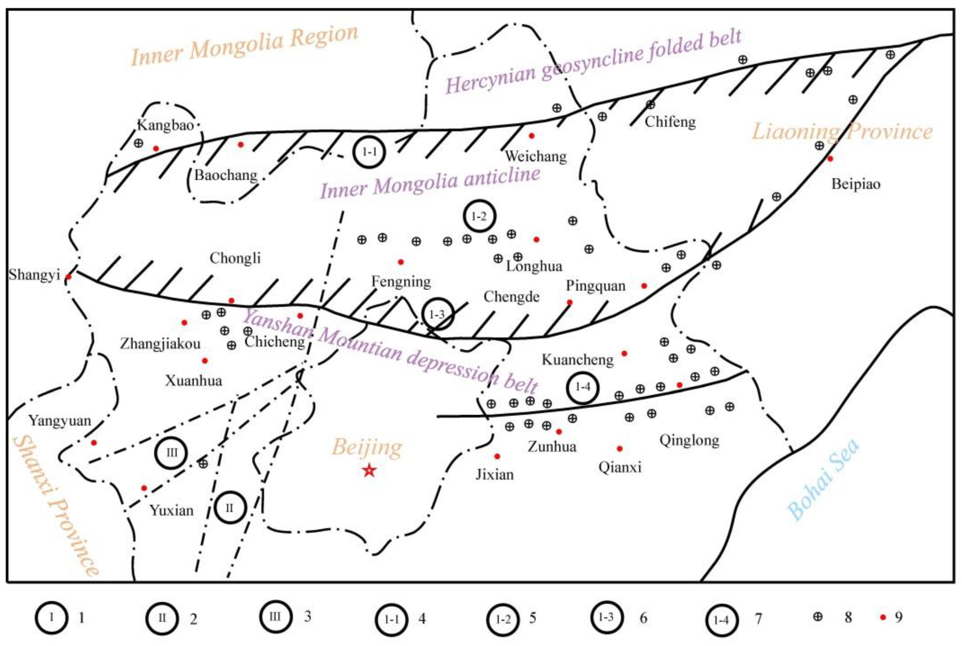
Figure 2.
Simplified geological map of the gold deposits in the Zhangjiakou gold province (after Yin et al., 1995 & 2021) [1,5,6]. Quaternary sediments; Tuff conglomerate, sandstone and breccia of the hanging Jurassic system; Sandstone, siltstone and dolomite of the Proterozoic Changcheng system; Metamorphic granulite of the late Archean Hongqiyingzi Group; Metamorphic granulite of the Aijiagou Formation of the Archean Sanggan Group; Gneiss of the Shuidizhuang Formation of the Archean Sanggan Group; Metamorphic granulite of the Jiagouhe Formation of the Archean Sanggan Group; Granite of the Yanshan orogeny; Amphibolite monzonite of the Hercynian orogeny; Pyroxene amphibolite monzonite of the Hercynian orogeny; Quartz monzonite of the Hercynian orogeny; Amphibolite adamellite of the Hercynian orogeny; Syenite of the Hercynian orogeny; Pyroxenite of the Hercynian orogeny; The Proterozoic granite-gneiss; The Archean granite-gneiss; The Archean metamorphic mica quartz diorite; Marginal migmatization zone of the monzonite; Fault and/or fault zone; Small to large size gold deposits; Town and/or village.
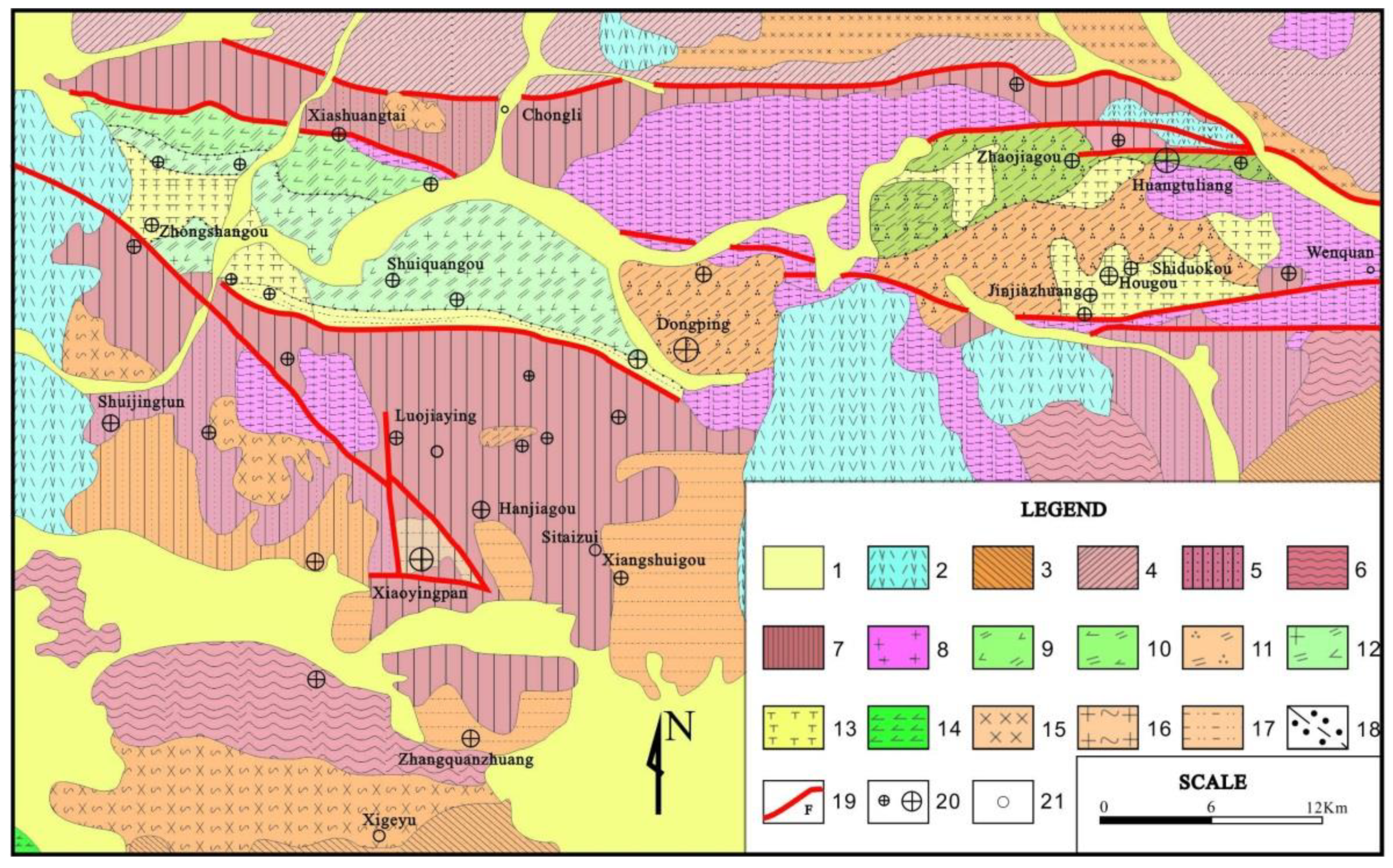
Figure 3.
Structural outline of the Zhangjiakou gold province. Yanshanian syncline; Early Precambrian third stage antediluvian folds; Early Precambrian second stage reverse antediluvian folds; Early Precambrian first stage reversed complex syncline (form) folds; Himalayan fault zone; Yanshanian fault zone; Archean fault zone revived in the Yanshanian; Deep and large fault zone since the Archean; Archean fault zone; Faults of unknown nature; Quaternary; Jurassic volcanic-sedimentary rocks; Mesoproterozoic Changchengian marine sedimentary rocks; Lower Proterozoic Hongqiyingzi Group; Archean Sanggan Group Jiangouhe Formation metamorphic rocks; Archean Sanggan Group Huajiaying Formation metamorphic rocks; Archean Sanggan Group Shudizhuang Formation metamorphic rocks; Metamorphic rocks of the Xigeyu Formation of the Archean Sanggan Group; Yanshanian granite (porphyry); Hercynian alkaline complex (unclassified).
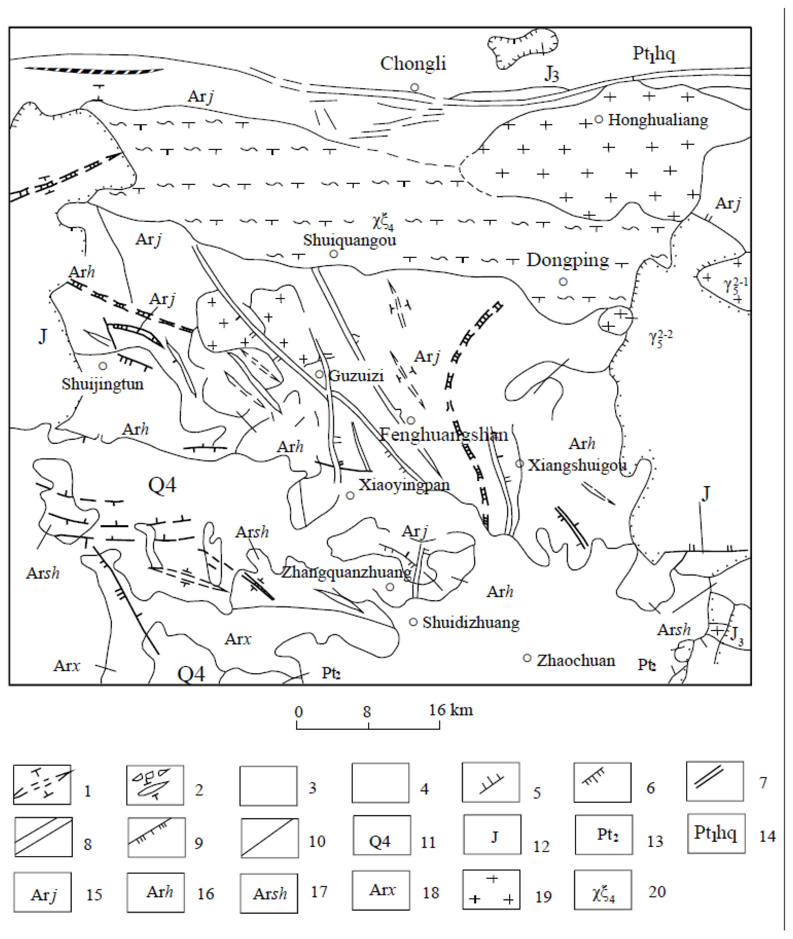
Figure 4.
Ore-hosting structure of the Xiaoyingpan gold deposit in the Zhangjiakou gold province [1,2,3,4]. Schistose of the host rock; The fold axis plane; Gold-bearing quartz vein/ore body.
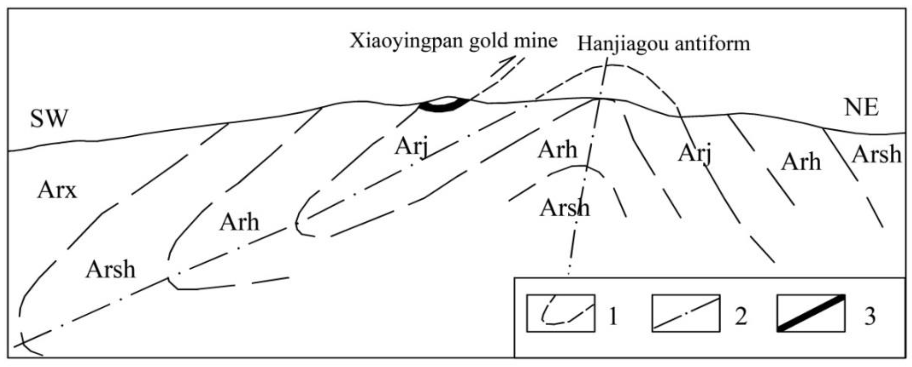
Figure 5.
The extensive impact of the Chongli-Chicheng deep fault zone and its control over the Zhangjiakou gold province.
Figure 5.
The extensive impact of the Chongli-Chicheng deep fault zone and its control over the Zhangjiakou gold province.
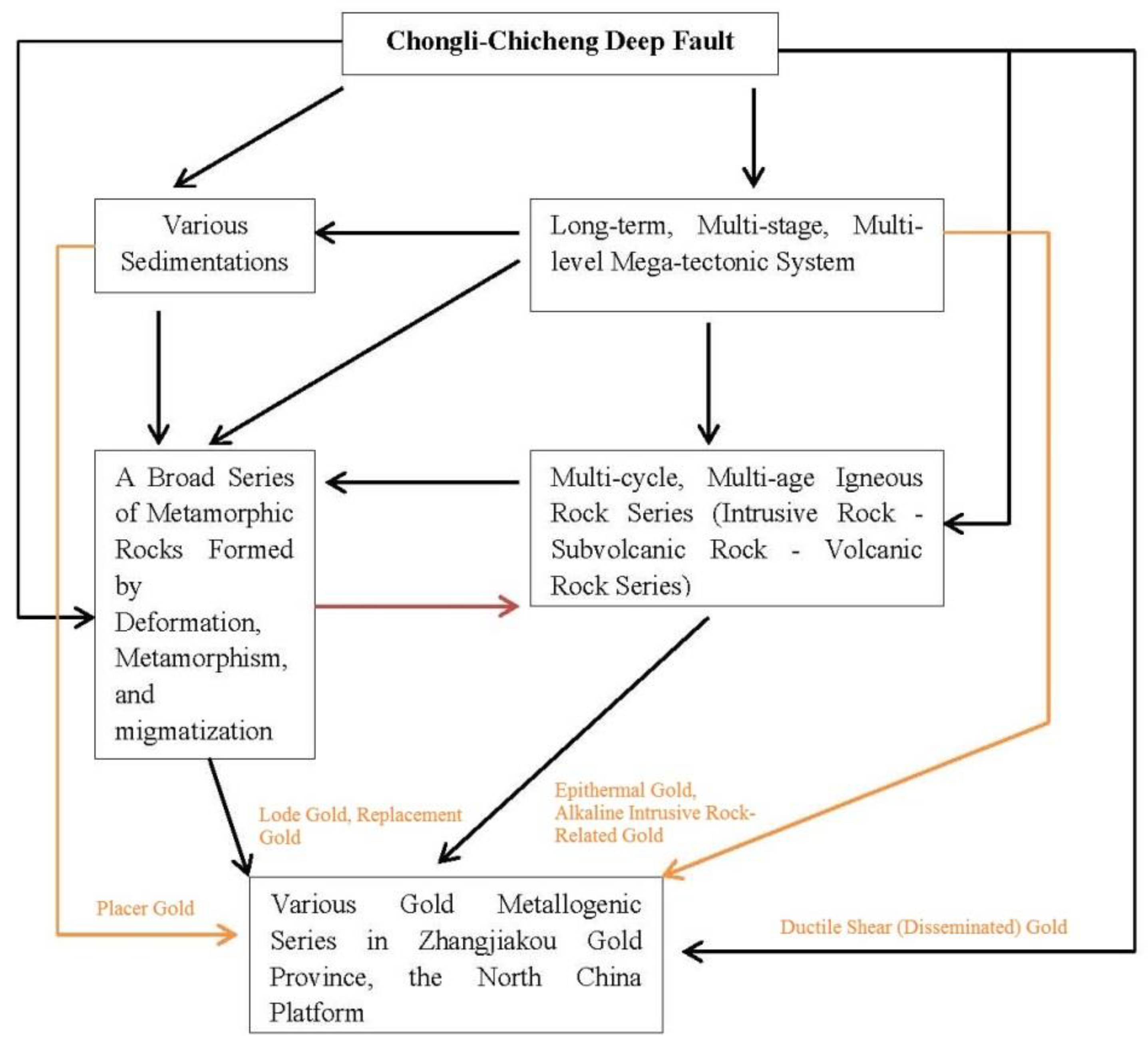
Figure 6.
Cross section of the main ore-hosting structure of Xiaoyingpan gold deposit and its relationship with the surrounding rocks of both the hanging wall and the foot wall. Metamorphic rocks of the Huajiaying formation of the Archean Sanggan group; Metamorphic rocks of the Jiangouhe formation of the Archean Sanggan group; Gold-bearing quartz vein/ore body; Altered rocks; Fault.
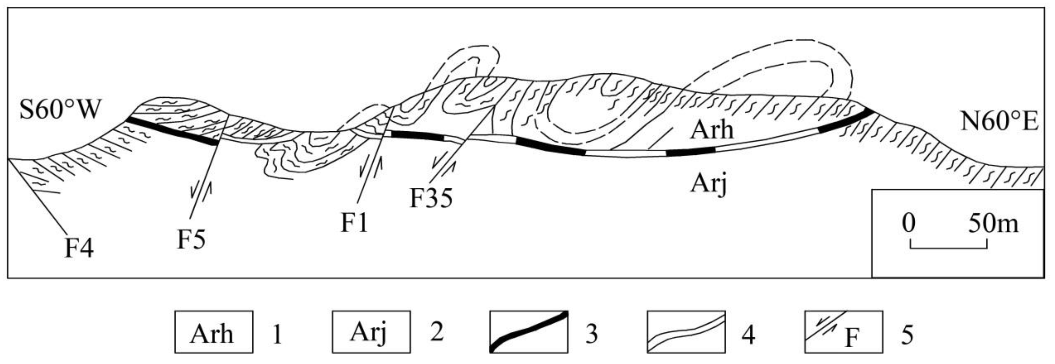
Figure 7.
Sketch map of grid-like quartz stockwork veins in Dongping gold mine (#36 Drift, 1503 Level) [39]. 1. potassium feldspar altered monzonite; 2. grid-like quartz stockwork vein (Q1); 3.fault.
Figure 7.
Sketch map of grid-like quartz stockwork veins in Dongping gold mine (#36 Drift, 1503 Level) [39]. 1. potassium feldspar altered monzonite; 2. grid-like quartz stockwork vein (Q1); 3.fault.
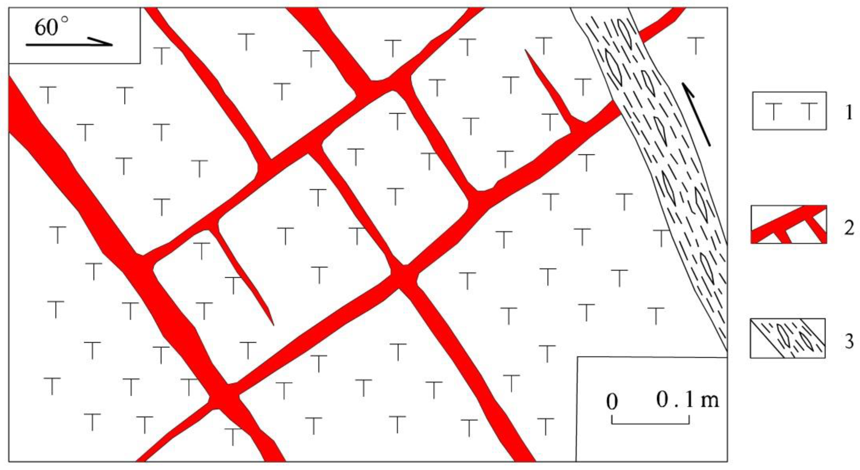
Figure 8.
Sketch map of quartz vein (Q3) formed in the third paragenetic stage in Dongping gold deposit (on the roof, 1464 Level) [39]. 1. monzonite; 2. quartz vein (Q3); 3. potassium feldspar altered monzonite; 4. ore body range.
Figure 8.
Sketch map of quartz vein (Q3) formed in the third paragenetic stage in Dongping gold deposit (on the roof, 1464 Level) [39]. 1. monzonite; 2. quartz vein (Q3); 3. potassium feldspar altered monzonite; 4. ore body range.
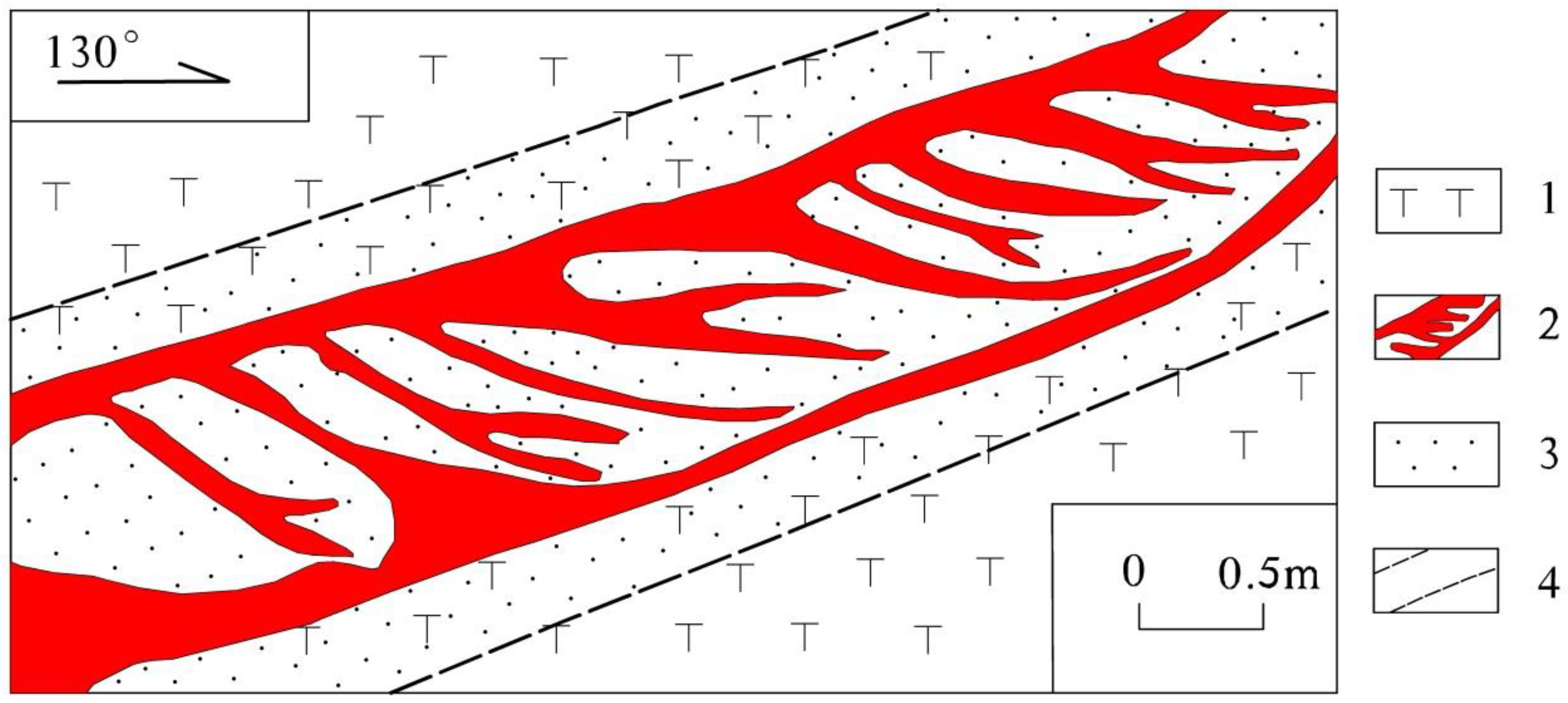
Figure 9.
Location map of the Cariboo gold mining district, British Columbia, Canada.
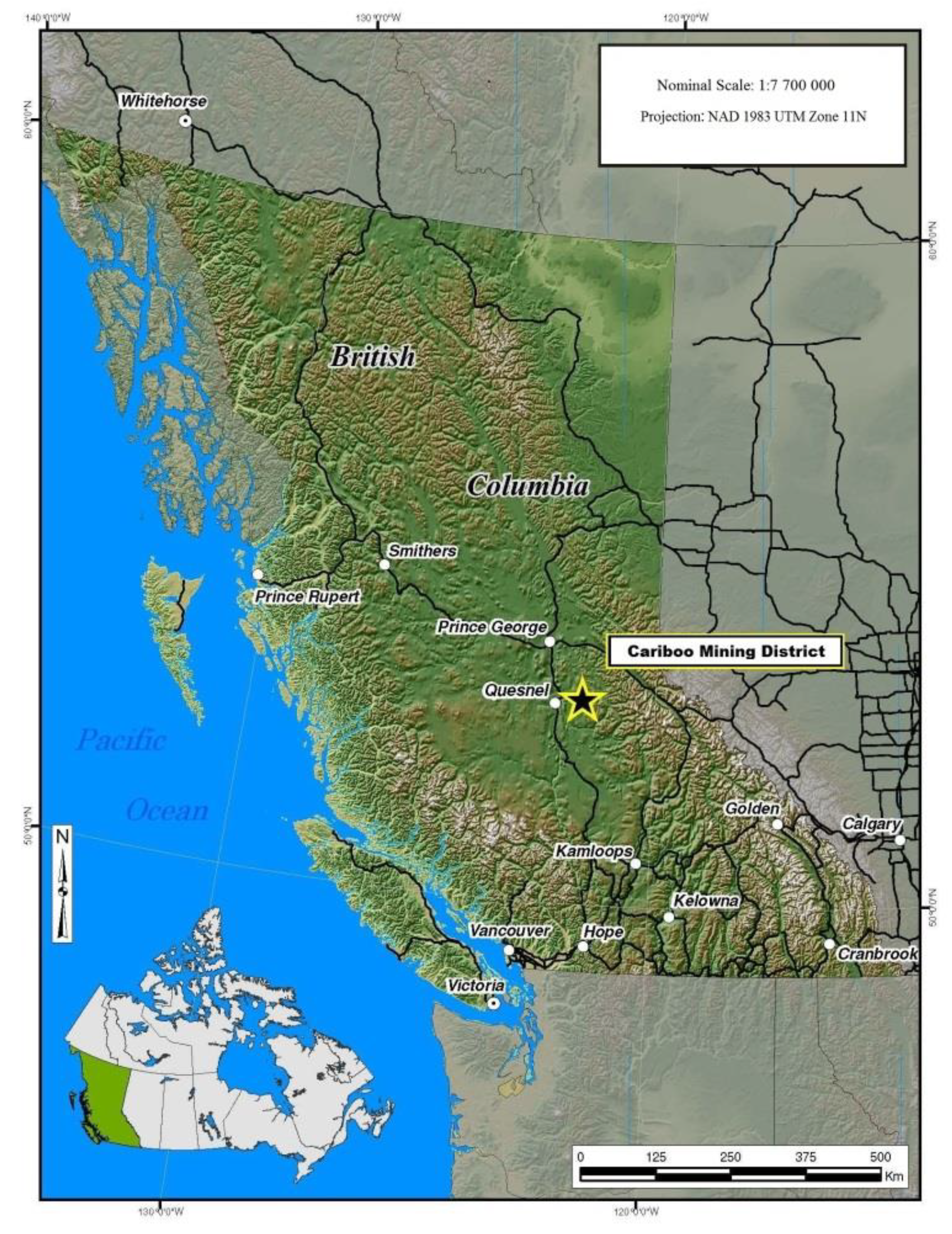
Figure 10.
Regional geology of the Cariboo gold mining district [41].
Figure 10.
Regional geology of the Cariboo gold mining district [41].
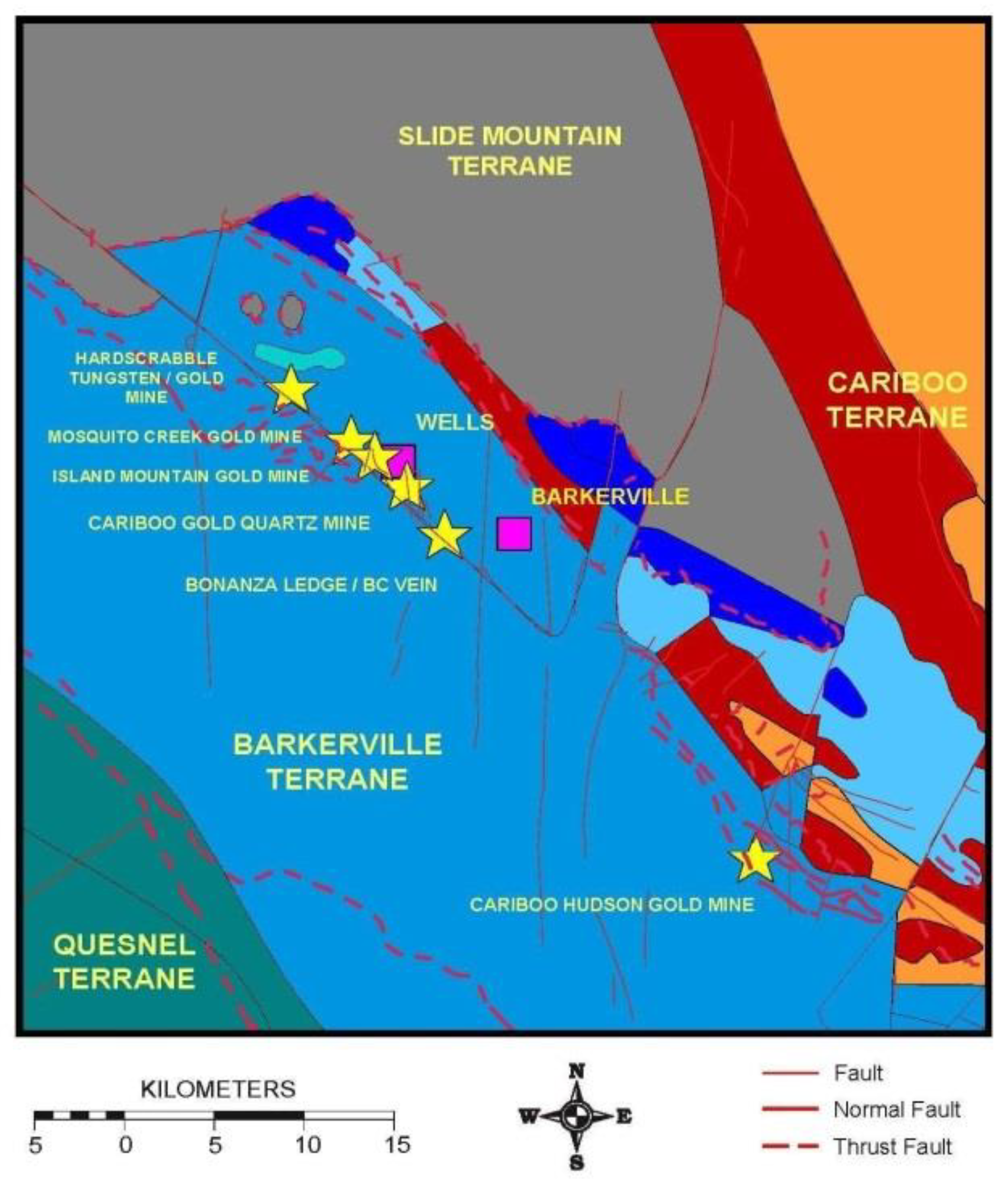
Figure 11.
Geology and long section of the Cariboo mining district [41].
Figure 11.
Geology and long section of the Cariboo mining district [41].
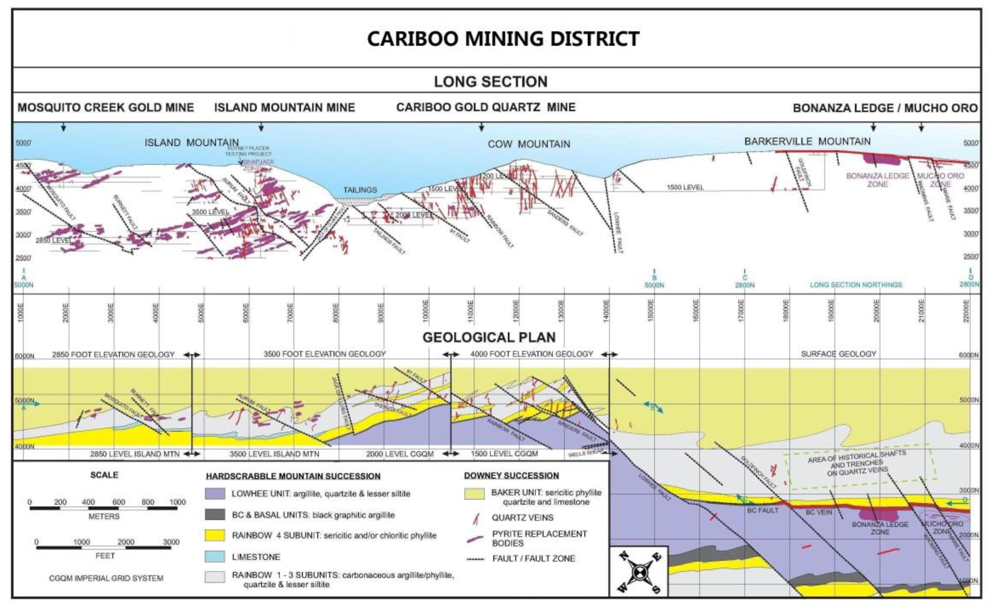
Figure 12.
The control of the world's first Te-Bi-Au deposit by the Ø-shaped structure formed by the intersection of linear and circular structures [57]).
Figure 12.
The control of the world's first Te-Bi-Au deposit by the Ø-shaped structure formed by the intersection of linear and circular structures [57]).

Figure 13.
Stability and bifurcation of solutions of reaction-diffusion equations (After Yu [60]). X represents the amplitude of the solution of the equation, and the solid line and the dotted line represent the stable solution and the unstable solution, respectively; λc is the critical value of λ; A is the branch point; a and d represent thermodynamic branch, b and c represent its branches.
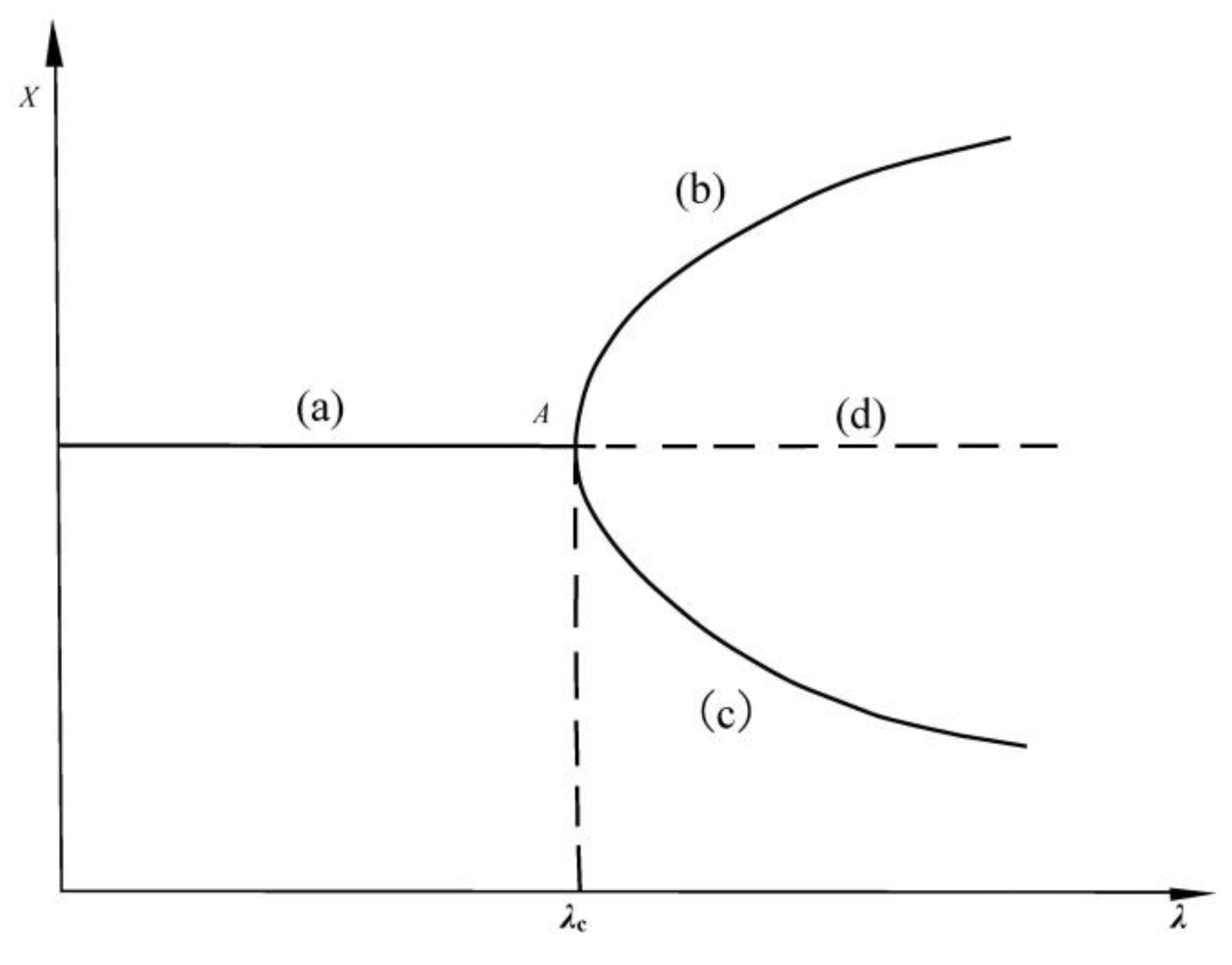

Table 1.
The key geological events in Zhangjiakou gold province.
| Major Geological Events in the Region | Relative Geological Period | Isotopic age | ||||||||||
|---|---|---|---|---|---|---|---|---|---|---|---|---|
Early  Late Late |
Ma | |||||||||||
| Early | Volcano-sedimentary processes and mafic and ultramafic intrusions | …. | >2800 | |||||||||
 |
High-amphibolite-granulite metamorphism (Chongli-Chicheng (deep fault begins to be active) |
…. | 2790 ± 155 | |||||||||
| Regional migmatization | …. | 2500-2400 | ||||||||||
| Amphibolite-facies retrograde metamorphism | …. | 2400 | ||||||||||
| Greenschist-amphibolite retrograde metamorphism | …. | 1800-1500 | ||||||||||
| Localized migmatization | …. | 600-450 | ||||||||||
| Main dike emplacement | …. | 380-242 | ||||||||||
| Alkaline complex emplacement | …. | 273-203 | ||||||||||
| Mineralization of major gold deposits | …. | 260-150 | ||||||||||
| Late | Part of the porphyritic granite emplacement | …. | 188-156 | |||||||||
Table 2.
Lode gold deposit type in the Cariboo gold mining district.
| Lode gold type | Sub-type | Representative gold deposit |
|---|---|---|
| auriferous pyrite replacement | limestone hosted | Mosquito Creek, Aurum, Island and Cow Mountain gold deposit |
| clastic rock hosted | Bonanza Ledge gold deposit on the Barkerville Mountain | |
| basalt-hosted gold-bearing pyrrhotite-pyrite lode gold | N/A | QR gold deposit |
| auriferous pyrite-quartz vein/veinlet lode gold | strike quartz vein | BC Vein on Barkerville & Cow Mountains |
| diagonal quartz vein | Hardscrabble W-Au Mine, Island, Cow and Barkerville Mountains | |
| orthogonal quartz vein | Island, Cow and Barkerville Mountains; Cariboo Thompson & Cariboo Hudson Gold Mines | |
| quart veinlet | Island, Cow and Barkerville Mountains | |
| associated gold in porphyry copper | N/A | Mount Polly porphyry copper |
Disclaimer/Publisher’s Note: The statements, opinions and data contained in all publications are solely those of the individual author(s) and contributor(s) and not of MDPI and/or the editor(s). MDPI and/or the editor(s) disclaim responsibility for any injury to people or property resulting from any ideas, methods, instructions or products referred to in the content. |
© 2025 by the authors. Licensee MDPI, Basel, Switzerland. This article is an open access article distributed under the terms and conditions of the Creative Commons Attribution (CC BY) license (http://creativecommons.org/licenses/by/4.0/).
Copyright: This open access article is published under a Creative Commons CC BY 4.0 license, which permit the free download, distribution, and reuse, provided that the author and preprint are cited in any reuse.


