1. Introduction
Restoration practitioners need a clear structure to design effective projects, including overall goals, measurable targets, and objectives. The Society for Ecological Restoratio
n’s International Principles and Standards for the Practice of Ecological Restoration (SER Standards) [
1] recommends that restoration targets be developed from reference models of site conditions. That is, “the expected condition that the restoration site would have been in had it not been degraded, while accounting for anticipated change” [
1]. Reference models optimally reflect a variety of information sources, include multiple reference sites of similar ecological conditions, and acknowledge the dynamic character of ecosystems. Challenges to constructing reference models include limited knowledge of undegraded conditions and data sources that may be difficult to locate or access. Also, planners may lack appropriate frameworks to organize information and construct reference models.
Our objective is to use source information from ecological classifications and vegetation inventories, along with frameworks and data for assessing ecological integrity and climate change vulnerability, to assist with evaluating site conditions and propose a reference model of our site. We recommend a stepwise process to compile and synthesize common map, text, and tabular information from reference materials and sites to develop models with clear attributes to set and communicate restoration targets. By systematically utilizing commonly available data in the USA, we streamline the process of establishing these models. While our case study addresses only dryland ecosystems, analogous information for wetland and aquatic ecosystem conditions should be sought in those circumstances. We used the SER Five-star System and Ecological Recovery Wheel to concisely communicate both current conditions and reference models. We anticipate that restoration practitioners could replicate this process for developing models applicable to a given restoration project area.
2. Materials and Methods
2.1. Colorado National Monument—Case Study
Our case study is a degraded area designated for restoration (restoration site) within the Colorado National Monument (Monument), a unit of the United States National Park Service (NPS). The Monument is a nearly 8,300 hectare protected area along the Colorado River in western Colorado, USA. Ecologically, the Monument reflects the transition from montane forests down to cold desert tablelands of the Colorado Plateau where it receives 28 cm of precipitation per year. The Monument is dominated by pinyon-juniper woodlands on sandstone mesas and tablelands but also includes over 570 hectares of cold semi-arid desert shrubland and grassland. These shrublands are often dominated by various species of sagebrush (
Artemisia spp.) on piedmonts and flats that form the eastern wildland-urban interface (WUI) with the adjacent city of Grand Junction [
2]. The restoration site is at about 1,450 m elevation above sea level and encompasses roughly 350 hectares of the WUI occurring as a 14 km strip (~250 m wide) from just north of the Monument entrance and extending south. The Monument vegetation inventory indicates the current restoration site is predominantly composed of three vegetation types dominated by four-winged saltbush (
Atriplex canescens), black sagebrush (
Artemisia nova), and invasive cheatgrass (
Bromus tectorum) respectively.
This area had been heavily grazed by captive bison (
Bison bison) that were brought into the Monument in the 1920s in support of tourism [
3]. The bison were removed in the 1980s after years of negatively impacting the area. The impacts from bison, plus other surface disturbances from a Civilian Conservation Corp camp established in the project area from the 1930s-40s, severely degraded the area. The shrub and grass communities of the restoration site now reflect severely altered composition and patchy dominance of invasive plants species in a condition that is worsening over time. The replacement of the native plant species by invasives has decreased native biodiversity.
The NPS is mandated to conserve the natural and cultural resources under its jurisdiction. Intervention is directed “to restore natural ecosystem functioning that has been disrupted by past or ongoing human activities (NPS 2006).” Temporal dimensions frame NPS restoration by considering past, current, and likely future conditions as a guide for developing restoration targets. Here we clarify sources to describe reference conditions with current and historical source materials but will also consider likely effects of intensifying nearby land use and climate stress emerging over upcoming decades.
2.2. Analytical Frameworks and Data Sources
Monument managers identified priority sites within the larger degraded area, and the SER Standards recognize the need for multiple reference models for use in distinct zones in similarly complex sites. These models are described by key ecosystem attributes including absence of threats, physical conditions, species composition, structural diversity, ecosystem function, and external exchanges (e.g., species dispersal, landscape dynamics, etc.). In turn, these are applied to a Five-star System developed to document restoration projects across a trajectory of recovery, and to help managers communicate the progress of their work.
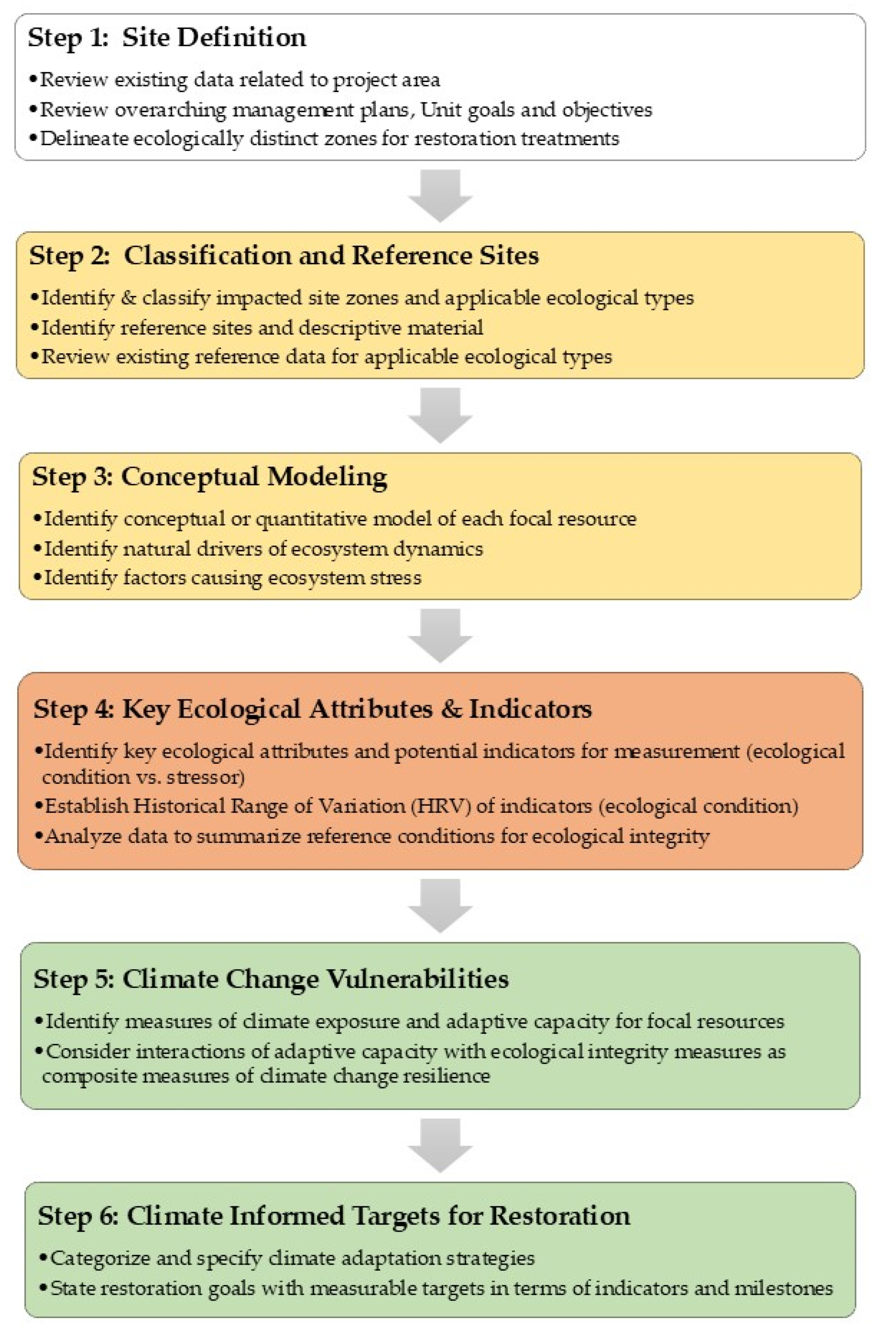
Figure 1 illustrates our stepwise workflow for integrating frameworks (ecosystem classification, ecological integrity assessment, and climate change vulnerability and adaptation), and data to construct reference models for site restoration. Steps 1-6 encompass key activities starting with Site Definition and ending with establishing Climate Informed Restoration Objectives that can be measured and monitored with implementation.
In this context, we integrate existing analytical frameworks and applicable data to identify potential reference models generated in part from existing reference sites. While three restoration zones were delineated within the restoration site, here we focus on explaining reference model development for just one—the largest—of those zones. Last, we integrate our information sources to propose preliminary ecological restoration targets for the restoration zone. See Supporting Information for additional background and detail of methods covered below.
2.3. Ecosystem Classifications
As noted above, the restoration site at the Monument includes three zones. We delineated these using map and field observations of geophysical substrates, related dynamic ecological processes, and site history. Criteria need to be set to justify delineation, so multiple sources of information were sought as recommended by the SER Standards. Ecosystem classifications are a practical starting point for documenting reference models suited to the distinct restoration zones within the project site.
Ecosystem classifications take several common forms in the USA. In terrestrial environments, a focus on rooted plant assemblages, or vegetation, is quite common [
5], while others emphasize geophysical components, like Natural Resource Conservation Service (NRCS) ecological sites, or those affecting wetland hydrology or soil productivity [
6] or some combination of the two [
7]. Terrestrial ecological classifications are developed in part from analysis of reference vegetation sample plots—selected from across the known natural range—to help define distinct but recurring types [
7]. In aquatic environments, ecological classifications are much more limited, but they tend to emphasize geophysical attributes (hydrologic regime and water chemistry) in type definitions [
8].
Three of these ecological classification products—from the U.S. National Vegetation Classification (USNVC), the NatureServe terrestrial ecological systems [
7] as used in LANDFIRE Biophysical Settings (BpS), and Natural Resource Conservation Service (NRCS) Ecological Site Descriptions—are complementary and widely available for application across the USA. We brought them together to form a foundation for the reference model for our restoration zones at the Monument.
2.4. Reference Data Describing the Types to be Restored
NPS vegetation inventories document existing vegetation occurring within the park boundary [
9]. We used both maps and vegetation sample data (i.e., plots measuring percent cover of plant species and then labeled to classification type) to evaluate and describe vegetation types likely to occur in the restoration site, and the floristic composition of targeted vegetation as they occur locally.
2.5. Modeling Landscape and Ecosystem Dynamics
Conceptual “State-and-Transition” models (STMs) describe key ecosystem components, their driving ecological processes, and their natural variation over time and space, and typify a reference site. Such defining characteristics may be viewed as the “Key Ecological Attributes” [sensu 10] of that resource. We used existing STMs originating with LANDFIRE BpS and with NRCS ESD classifications as two primary sources. While ESDs are not available comprehensively in the USA, they do encompass a large proportion of the country, especially in western states. LANDFIRE BpS models exist for all natural types in the USA. They initially highlight geophysical constraints and dynamics one should anticipate in undegraded conditions. The ESDs, while not quantitative like LANDFIRE models, do describe effects of common ecological stressors or management practices.
2.6. Identify Indicators for Restoring Ecological Integrity
A primary goal for natural resource managers is the maintenance and restoration of ecological integrity [
10]. A given ecosystem has integrity when its dominant ecological characteristics (e.g., elements of composition, structure, function, and ecological processes) occur within their natural ranges of variation and can withstand and recover from most perturbations imposed by natural environmental dynamics or human disruptions [
11]. Therefor, ecosystems with high levels of integrity have high levels of resistance and resilience to disturbances to which they are adapted. The Ecological Integrity Assessment Framework (EIAF) as described by Unnasch et al. [
10]), provides one structured approach to identifying ecologically relevant measures for integrity assessment with direct application to restoration sites.
Relevant to reference model development, the EIAF describes identification of:
- 1)
Key Ecological Attributes (KEAs) driving natural states and transitions,
- 2)
measurable indicators of those attributes,
- 3)
the expected/historic range of variation for each indicator; and,
- 4)
practical thresholds for indicator measurements suggesting restoration milestones
2.7. SER Five-star System and Ecological Recovery Wheel
We applied outputs of the data, frameworks, and models (above) to the SER Five-star System [
1,
12,
13]. The System is a tool used to identify the level of recovery of the system, from partial recovery to full recovery. It works with the Ecological Recovery Wheel graphic that shows five condition levels for key ecosystem attributes (e.g., structural diversity) and sub-attributes (e.g., spatial mosaic) [
sensu 1].
2.8. Vulnerability and Adaptation to Climate Change
Climate change vulnerability is commonly defined as “the degree to which a system is susceptible to, or unable to cope with, adverse effects of climate change, including climate variability and extremes” [
14]. Vulnerability assessments tend to include a series of measurements to quantify climate change exposure, sensitivity, and adaptive capacity. We used outputs from NatureServe’s Habitat Climate Change Vulnerability Index [
15] as applicable to our target ecosystem type. These results directly inform adaptation strategies, such as selecting species for reintroduction or enrichment, or restoring natural disturbance processes [
16].
3. Results
Site definition was included above in our Case Study, so here we start by summarizing a stepwise workflow for organizing and applying available information. We then report on results with use of ecological classifications and reference site data. Again, see Supporting Information for additional detail of results covered below.
3.1. Classification and Reference Sites
The NPS vegetation inventory indicates vegetation in distinct categories, including invasive cheatgrass, two-needle pinyon (Pinus edulis)-Utah juniper (Juniperus osteosperma) and multi-shrub woodland, and four-winged saltbush, black sagebrush, and grasslands. Site visits clarified that black sagebrush was limited to a portion of the restoration area with alkaline bedrock outcroppings and related soil in a small portion of the overall site. Similarly, Four-winged saltbush was found along with greasewood (Sarcobatus vermiculatus) in shallow washes from intermittent streams draining down from adjacent tablelands.
Most of the restoration site falls within polygons mapped as two-needle pinyon-Utah juniper “multi-shrub” woodland and defined the ecotonal transition from adjacent pinyon-juniper woodland on steep slopes onto the gentle plain. These areas appear to have supported big sagebrush (Artemisia tridentata ssp. wyomingensis or ssp. tridentata) as a dense shrubland or open grassy steppe; but is currently dominated by invasive cheatgrass. Local plant communities, as defined at the Association level of the USNVC that most closely match likely local conditions include Artemisia tridentata ssp. wyomingensis / Pleuraphis jamesii Shrubland and Artemisia tridentata ssp. wyomingensis / Hesperostipa comata Colorado Plateau Shrubland.
3.2. Reference Site Data Describing the Types to be Restored
NPS vegetation inventory for the Monument included 239 samples that were labeled to USNVC Associations that were either dominated by Wyoming big sagebrush or by Pinyon-juniper woodland that included sagebrush in the understory. These assist with characterizing local floristic composition in our reference model. Supporting Information includes a list of characteristic plant species in these data that include Wyoming big sagebrush and other shrubs along with common grass species in these sites. These were augmented with type descriptions from the USNVC Associations.
The LANDFIRE BpS map indicates pinyon-juniper woodlands and big sagebrush types occurring throughout the Monument and in adjacent lands. Big sagebrush shrublands are mapped in small patches within the project area, but likely as an artifact of the site being a long narrow strip, most are mapped with the biophysical setting of the pinyon-juniper woodland occurring on adjacent slopes (Supporting Information). Therefore, we inferred that the restoration site would have been big sagebrush shrubland and steppe had historical degradation not occurred. Using the NatureServe ecological systems classification, this would equate with Inter-Mountain Basins Big Sagebrush Shrubland. We will refer to this as our focal resource (sensu 10) which is the focal unit for efficient analysis.
3.3. State and Transition Models
The description of the LANDFIRE biophysical setting Inter-Mountain Basins Big Sagebrush Shrubland—Upland (BpS 10804) indicates that wildfire is the primary natural disturbance agent, characterized by replacement fire in all succession classes, although fire return intervals (FRIs) vary by class. Since this BpS can occupy vast areas, historic disturbance (fire) likely ranged from small (<4 hectares) to very large (>4,000 hectares) depending on conditions, time since last ignition, and fuel loading.
Five natural successional classes are described, including early, mid, and late stages, some with open and others with closed shrub canopy. In each area, not all stages from A-E may occur. One pathway leads to late development with closed canopy, while another retains open canopy conditions. Modeling that simulates a natural fire-regime results in the following percentage (in parentheses) of each succession class one could expect across a given landscape supporting this biophysical setting. Percentages are approximate and should be applied assuming a 5% range of variation.
A) Early Development 1—All Structures (15% of type in this stage)
B) Mid Development 1 Open (shrub-dominated—50% of type in this stage).
C) Mid Development 1 Closed (shrub-dominated—25% of type in this stage)
D) Late Development 1 Open (5% of type in this stage)
E) Late Development 1 Closed (5% of type in this stage)
That is, about 15% of a given land area would likely occur as early successional stage development and 50% would occur as mid stage but open shrub canopy. The remainder would occur as succession classes C-E. See Supporting Information for detailed description of the LANDFIRE model.
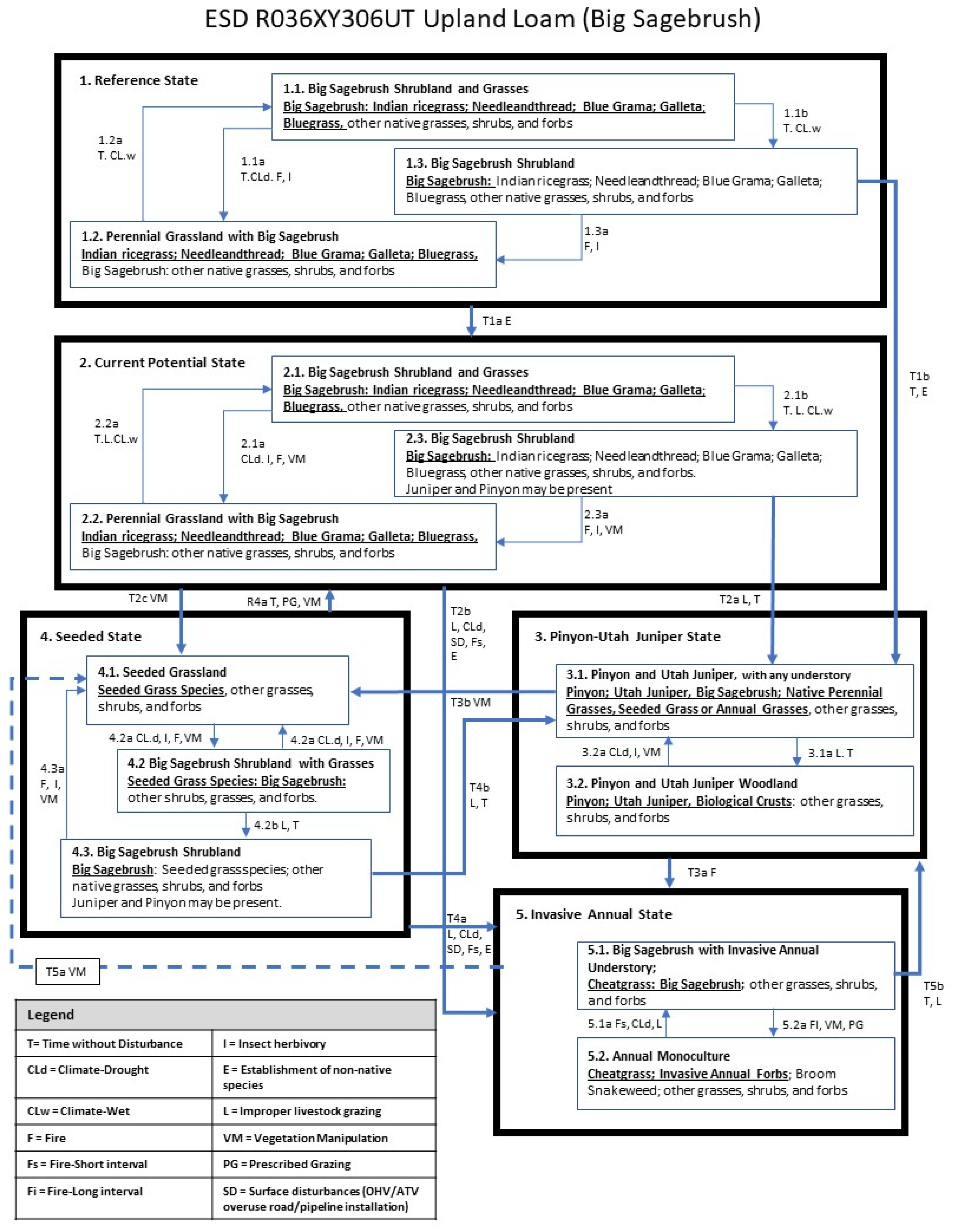
The NRCS Ecological Site Description most applicable here is R034BY306UT Upland Loam (Wyoming Big Sagebrush) (
Figure 2). While less quantitative than the LANDFIRE model, this conceptual model describes a “reference state” with three common natural conditions, including big sagebrush and varying densities of shrub vs. grasses. It also describes a current potential state that could include effects of livestock and vegetation management. A related Pinyon-Utah Juniper State results from improper livestock grazing over time, and with surface disturbance and short fire return intervals, an invasive annual grass state may dominate. With more direct management or restoration actions, a Seeded State can be produced. Within each of these main states, internal dynamics are expressed in terms of direction change based on various natural factors, stressors, and types of vegetation management.
Among the primary factors resulting in change among these states are succession (or “time without disturbance”), fire (presence, short interval, or long interval), insect herbivory, establishment of non-native species, improper livestock grazing, and surface disturbance. Vegetation management is expressed as either vegetation manipulation or prescribed grazing. A number of these dynamics could be affected by climate condition, in this case, simply stated as with “drought” or “wet” conditions.
The current conditions of the restoration site could be mostly characterized as the Invasive Annual State in the model. It likely arrived at that state through surface disturbance, past improper grazing, and introduction of non-native species. The model suggests that with continued time without fire and improper livestock grazing, a transition toward a Pinyon-Utah Juniper State would be likely. There is also the potential for vegetation manipulation shifting the site toward a Seeded State. Generally, this refers to areas that were seeded with a standard range seed mix, which could include non-native species, with an emphasis on soil stabilization and production for grazing or haying. These states could be stagnant in terms of recovery to a restoration target or be part of that recovery trajectory. The NRCS ESD provides general suggestions and implications (likelihood of success, changes in production) for types of species that could be seeded. Therefore, a restoration planner could use this section of the model to include desired species and restoration actions to recover ecosystem integrity.
3.4. Key Ecological Attributes and Indicators of Ecological Integrity
Following the EIAF process for the Monument restoration site, key ecological attributes for this big sagebrush shrubland restoration site can include:
Landscape-scale Processes Requiring Connectivity
Community Composition Contribution to Characteristic Ecological Processes
Vegetation Structural Response to Disturbance
Wildfire Regime
Chemical & Physical Processes
Both condition and stressor-based indicators (10) have been identified to measure these attributes (
Table 1). For example,
Percent Cover of Invasive Annual Grass Species is a primary “stressor” based indicator of the Community Composition to apply in the field at this restoration site. Importantly, “stressor” based indicators would not have any expected natural range of variation, but instead occur along a continuum from lesser to greater degrees of stress on the resource. That continuum is likely be correlated with a range of variation among other “condition” based indicators under the ecosystem attribute “Species Composition,” like
Percent Cover of Native Plant Species or
Observed vs. Expected Vascular Plant Species Composition.
An indicator for the key ecological attribute of Vegetation Structural Response to Disturbance—Wildfire Regime—is constructed as an indicator of “condition” through a model of natural wildfire dynamics, but it measures departure from those presumed natural dynamics (arguably as expression of ecosystem stress).
We note below that “expert judgement” comes into play in our process. Here, expert judgement reflects to consensus or researchers and practitioners with extensive experience and expertise with the resource and/or management practice. Much of this has already been incorporated into some of the data sources and frameworks presented here.
3.4.1. Expected/Historical Ranges of Variation for Indicators
The expected range of variation for the selected condition and stressor indicators for big sagebrush shrubland are ideally described through comparative quantitative analysis of many reference locations. However, expert judgment can be used to establish initial approximations of these range. For example, with Percent Cover of Native vs Non-native Plant Species, a range from 50% to 90% could adequately express common condition for big sagebrush shrubland (Supporting Information).
The LANDFIRE Vegetation Departure Index (scored 0.0-1.0) addresses the effects of altered fire regimes on expected proportions of vegetation structural classes; based on assumptions documented in LANDFIRE State-and Transition Models (see above). Therefore, the model expresses the natural range of variation one would expect in vegetation structural classes given documented assumptions of vegetation succession and disturbance from natural wildfire. These models developed for rangewide application to a given biophysical setting/vegetation type could be further refined to local site conditions with local knowledge.
3.4.2. Indicators Thresholds
While often hard to identify one can presume that critical thresholds exist in the range of potential variation for each indicator of each key ecological attribute. There are a variety of ways to express thresholds that define the expected ranges of variation in the indicators for each key ecological attribute of a focal ecological resource. Some have used 3-5 generalized categories to characterize a range of “excellent” to “poor” conditions. One could equate “poor” conditions to a “threshold of imminent loss.” This is a hard threshold suggesting some form of ecological collapse at the site (Keith et al. 2013). Restoration may be initially focused on crossing this threshold from a current, apparently “collapsed” state to a state falling within the expected range of variation. Again, thresholds within the expected range of variation for the selected condition and stressor indicators for big sagebrush shrubland are ideally described through comparative quantitative analysis of many reference sites. However, once again, expert judgment can be used to establish initial approximations of threshold values and categories. For our example of Percent Cover of Native vs. Non-Native Plant Species, a set of thresholds could adequately express a set of conditions for big sagebrush shrublands; i.e., “poor” (<50%) “fair” (50-80%) “good” (80-90%) and “excellent” (>90%).
Similarly, for stressor-based indicators, expert judgement can be used to establish a parallel gradient, such as for Percent Cover of Invasive Annual Grass Species, a set of thresholds could adequately express a set of conditions for big sagebrush shrublands; i.e., “poor” (>10%) “fair” (3-10%) “good” (1-3%) and “excellent” (<1%).
For the LANDFIRE Vegetation Departure Index, measured either through remote sensing and spatial modeling of vegetation structure, or by field observation and estimation, the 0.0-1.0 index is tentatively thresholded into four categories from <0.3 suggesting “poor” of severe fire regime departure, to 0.31-0.6 for “fair” moderate to severe departure, and 0.61-0.9 for “good” or low to moderate departure, and 0.91 for “excellent” or no departure.
3.4.3. Scorecard of Indicators and Ratings
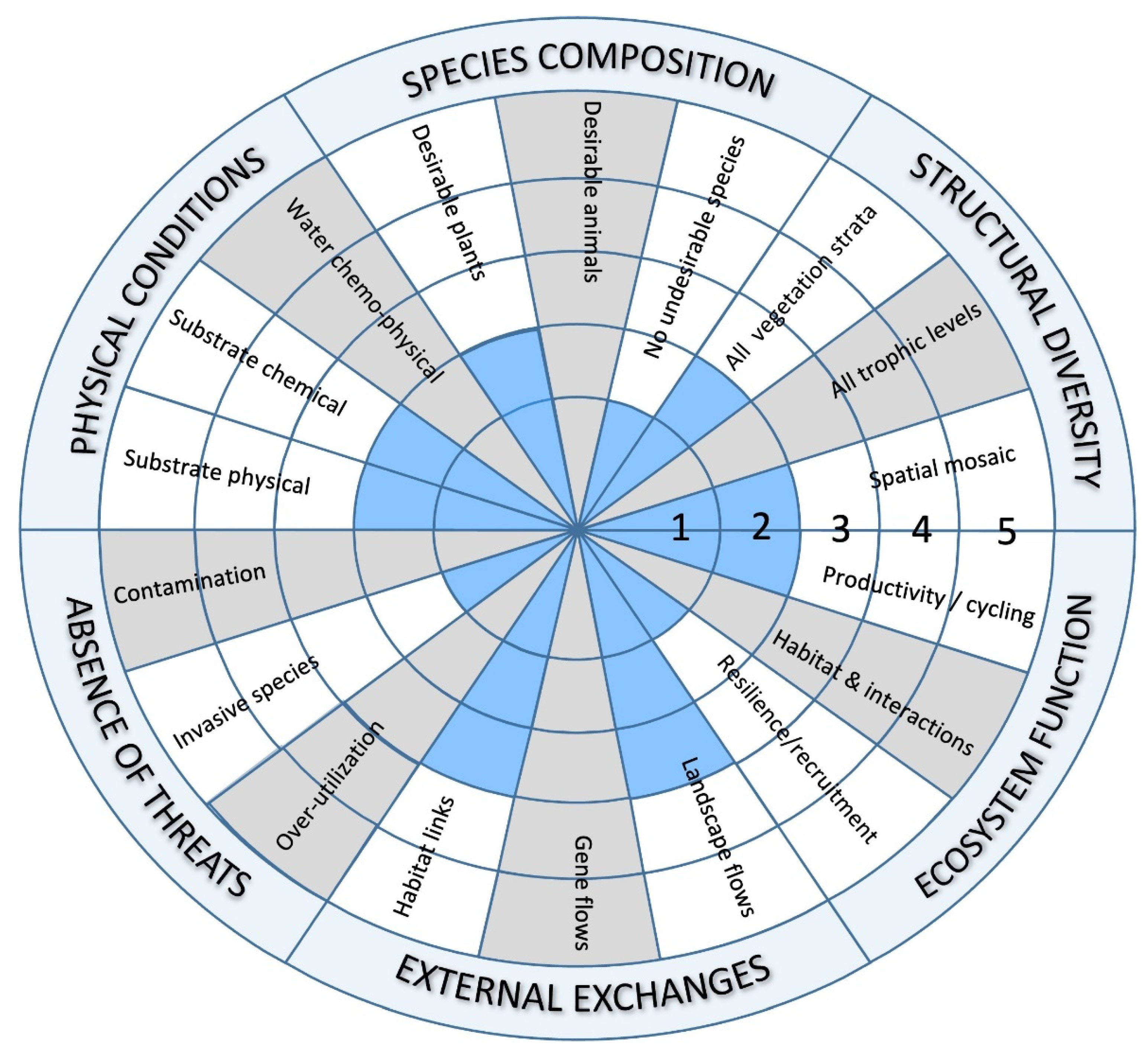
We used this information to suggest baseline conditions of indicators as shown in
Table 2 and as a Baseline Recovery Wheel in
Figure 3. While the Ecological Integrity and SER Five-star frameworks are not intended to crosswalk directly, we can set the highest levels of ecological integrity to the highest (5 star) level of recovery. Lower levels of recovery require not only information from our analytical frameworks, but an understanding of site management, including reduction of stressors, initial treatments, and related recovery. Our preliminary baseline scores are also based on secondary information, including a site visit and personal communications with Monument staff. Five-star categories contain 2 or more sub-attributes, requiring expert judgement to determine respective recovery levels. For example, EIAF analyses show loss of integrity when the ratio of native to non-native plant cover is less than 50%. The Five-star category for desirable plants includes finer delineations of species presence, not cover, beginning with “~2 %, or ~10%” at lower levels of native species recovery. This site likely includes much greater than 10% of the preferred species, but we assign only a single star for Species Composition in
Figure 2. To make this determination, we considered the high levels of undesirable, invasive species, the continued spread of these species, management focus on the areas of greatest degradation within the site, and lack of regeneration niche. Separate attempts to re-establish native species have yielded mixed results, including poor outcomes of seeding trials with Connectivity Modifiers in 2017 (PJC and GEE personal observation).
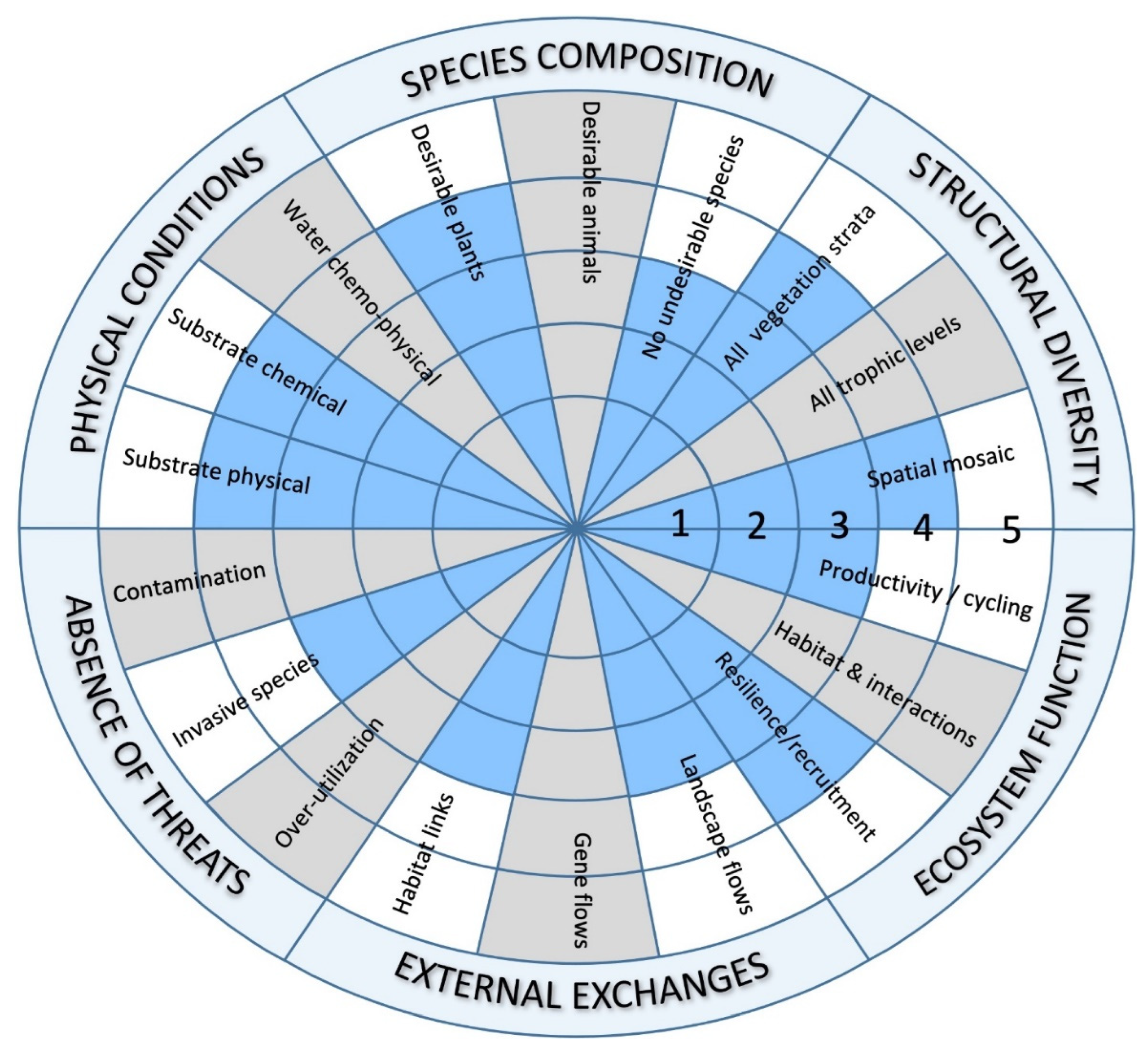
3.5. Preliminary Reference Target by Ecosystem Attribute and Sub-Attribute
We next used our full model to suggest a progression of recovery goals for select attributes. For example, many restoration site indicators might initially score within the “poor” EIAF category. The “fair” category may be established as an interim measurable restoration target. In this instance of Big Sagebrush Shrubland at the Monument, each of these indicators could be documented and, following the direction of the SER Standards, used to work towards “continuous improvement to the highest level of recovery attainable.” Subsequent measures could form a series of restoration goals within the “Good” category, falling within levels 3 and 4 for Five-star recovery goals and reporting (
Table 3 and
Figure 4).
3.6. Accounting for Climate Change
The climate change vulnerability assessment for our target Big Sagebrush Shrubland provides insights into likely climate change that affected our reference model (15). Supporting Information includes maps of projected change in suitability for this shrubland across its extensive range, and one can see variation in this changing suitability for the area encompassing the Monument.
Looking out to the 2035-2065 timeframe, this shrubland type in this part of the Colorado Plateau scores in the moderate level of overall vulnerability throughout its range. Mean annual temperature is projected to increase 2.7-3.4°C with similar increases projected for mean temperatures of the coldest quarter and minimum temperature of the coldest month. However, precipitation of the driest month is also projected to increase. While this increased precipitation would not mitigate increases in temperature, the projected climate change exposure appears to be moderate.
See Schmitz et al. (16) for additional guidance on steps for establishing climate informed restoration targets. These outputs can be interpreted using emerging frameworks for climate change adaptation, such as the Resist/Accept/Direct (RAD) (18) or Resistance/Resilience/Transformation (RRT) frameworks (19). In locations scoring relatively low in vulnerability, adaptive restoration can take a “resistance”-based approach. At the opposite extreme, very high vulnerability suggests serious consideration of “Direct” or “Transformation” -based strategies. In this instance, moderate vulnerability for upcoming decades suggests an accept or resilience-based stance in restoration. See
Table S15 in Supporting Information for generalized strategies using these frameworks suitable for application to this big sagebrush shrubland of our restoration site.
This means that the reference model based on knowledge of historical and current conditions remains generally appropriate, at least for the upcoming decades, as the requirement to develop project targets and decision documents to implement restoration actions. With advancing climate change science, and actual climate driven change in conditions on the ground, could require a change in stance into the future, but for the current planning cycles extending into the 2030s, no significant change is indicated.
4. Discussion
4.1. Ecological Restoration Is Challenging in Nearly All Circumstances
With accelerating environmental change due to land use and climate-driven stress, practitioners need ready access to analytical frameworks and data to organize information and establish practical and measurable restoration targets. We used one example from Colorado National Monument using commonly available information to efficiently develop reference models and identify measurable targets and to restore a degraded site. Additional effort will be required by local project managers to work with internal and external stakeholders to include indigenous and other management considerations. Restoration specialists can use these targets to design project workplans, making use of attributes and measures as the basis for monitoring work progress.
The SER Standards defines Reference Model as the presentation of the expected condition that the restoration site would have been had it not been degraded. Here, this presentation includes the text, tabular, and spatial information that express the condition of the target native ecosystem had degradation not occurred. The model also includes the key ecological attributes, indicators, and thresholds among those indicators for measuring ecological integrity. Those indicators provide the mechanism to describe relative degradation in baseline conditions on the site. They also provide potential milestones for evaluating progress in restoration. Our example is typical for sites across the United States and beyond, where the current condition of the site can obscure likely pre-degradation conditions, data from applicable reference sites may be limited or challenging to locate, and likely climate-driven stress may add considerable uncertainty. Therefore, the integration of multiple common forms of information was key to establishing a reference model, and existing analytical frameworks facilitated organization, evaluation, and documentation of conditions with sufficient detail to determine both practical and measurable site restoration targets. In this case study, source information from ecological classifications and vegetation inventories, along with frameworks and data for assessing ecological integrity and climate change vulnerability, were brought together to assist with evaluating site conditions. The SER Five-star System and Ecological Recovery Wheel provided a concise form to communicate both current conditions and restoration targets and goals.
4.2. Synthesizing Information Across Analytical Frameworks
As we developed our analyses, we evaluated the structure and terminology from our various sources. Many of the terms and concepts were compatible across frameworks. However, we had some challenges with differences in the use of “Key Ecological” versus “Key Ecosystem” attributes in the EIAF and SER Standards, respectively. SER’s “Key Ecosystem Attributes” are fixed, broad categories developed to assist practitioners with evaluating the degree to which biotic and abiotic properties and functions of an ecosystem are recovering. Categories are set relative to the highest level of reference conditions. The full set of categories should be evaluated for any restoration site, and users are directed to “develop indicators and monitoring metrics specific to the ecosystem and sub-attributes they identify.” In contrast, the EIAF considers Key Ecological Attributes to be the subset of ecological factors thought to be critical to the ecosystem’s response to both natural ecological processes and human-caused stressors. Change in key ecological attributes can result in degradation to a specific ecosystem type. They are identified through the development of a conceptual model of structure and process for individual focal resources. As noted by this example, the next step of identifying and scaling appropriate indicators of each attribute is particularly challenging and so the process of narrowing indicators to those most essential for measurement is of real value to the practitioner. But this means that the EIAF may lead practitioners to focus on just a subset of categories identified by the SER framework. So, while the EIAF and related frameworks must be combined with other sources to provide the full set of information needed for ecological restoration planning, monitoring, and evaluation, emphasis on the EIAF attributes for restoration activities may support recovery-based attributes in the 5-star System.
We considered this as we constructed our range of reference conditions, but overall, we found the two frameworks to be compatible. There are landscape scale processes requiring connectivity, such as seed dispersal and herbivory, that would be impacted by spatial isolation of the site. Plant community composition, especially including native shrub species, bunchgrasses, and characteristic forbs define the biotic assemblages of the site. Variation in vegetation structure is primarily related to shrub canopy and densities of bunchgrasses form in response to natural disturbance. The primary natural disturbance is wildfire, and so wildfire regime (e.g., frequency, intensity, patch size or extent) is important to describe ecosystem function. Finally, chemical, and physical attributes of soils (for stability, soil organic matter and moisture retention) contribute to physical conditions. In this case, we can see an additional application of the EIAF-based KEAs as those attributes of the degraded site that act as barriers to system recovery (20, 1). Focusing on these KEAs for active manipulations to the degraded ecosystem become the segue from assessment to restoration planning.
We did not identify readily-available data sources for all sub-attributes. Managers may determine the value of these and choose to develop project specific information to provide a comprehensive picture of site recovery. In this case study, the SER and EIAF approaches worked well together, but we note here that that might not always be the case, and additional work may be required from practitioners.
4.3. Coping with Climate-Induced Stress in Restoration Targeting
Our case study provided an opportunity to explore the implications of climate-induced stress on the restoration targeting. While for this site, the overall indication of climate change vulnerability appears to be moderate—at least up through the mid-21st century timeframe—one can see more clearly how existing frameworks for climate change adaptation could interact with those used here for identifying reference models and measurable restoration targets across a range of circumstances. As noted above, a ‘low-to-moderate’ climate change vulnerability assessment can suggest proceeding with outputs of the EIAF and SER frameworks and other “resilience” based strategies (sensu 19).
In the increasingly common case where climate change assessments suggest high-to very high vulnerability (15), practitioners can first refer to a decision tree provided in the SER Standards (1). This tool addresses a range of scenarios for long term changes to underlaying environmental conditions and guides readers through options for identifying appropriate reference conditions and level of restorative actions. Other tools provide more specific strategies to incorporate climate-related strategies for restoration where some form of ecological transformation (19) is either in progress or foreseen over upcoming years or decades. Where the climate change assessment provides sufficient detail, both thematically and spatially, for components of climate change exposure, sensitivity, and adaptive capacity for the degraded ecosystem being considered for restoration, alternative reference models could be established. These alternative models can be communicated in terms of indicators where the restoration of pre-degradation ecosystem conditions may no longer be achievable (e.g., historical species composition or structure) and or where entirely new targets are needed (e.g., new climate-induced natural disturbance regimes) (1; 21). Documented species composition and dynamics of naturally adjacent ecosystems can be one ready source for adaptive responses. In all cases or scenarios, an understanding of the role and status of the ecological attributes provides direction for managers as they evalaute adaptation options.
This case study served to illustrate a structured approach to compile information to define reference conditions for a restoration site to subsequently identify restoration targets. Given both existing and emerging challenges, use of practical analytical frameworks and all applicable available data will be of increasing importance to restoration practitioners.
5. Conclusions
5.1. Implications for Practice
Multiple sources of information should be sought to describe reference conditions and clarify restoration goals, including appropriate reference sites, which may be limited or challenging to identify for a given restoration project due to pervasive environmental degradation.
Several existing analytical frameworks and associated data sets can be combined with data from reference sites to establish practical reference models. Expert judgement is required to integrate these multiple sources of information.
Climate change vulnerability of targeted ecosystems can be documented, and appropriate adaptation strategies and restoration targets suggested to implement within set timeframes.
These data are synthesized to express key ecological attributes, measurable indicators, expected ranges of variation, and assessment categories of resources that are compatible with the SER Five-star System for ecosystem recovery.
Supplementary Materials
The following supporting information can be downloaded at the website of this paper posted on
Preprints.org.
Author Contributions
Conceptualization, P.J.C and G.E.E.; methodology, P.J.C, G.E.E. and G.D.G; validation, P.J.C, G.E.E. and G.D.G; formal analysis, P.J.C and G.E.E.; resources, P.J.C and G.E.E.; data curation, P.J.C and G.E.E.; original manuscript draft, P.J.C and G.E.E.; Writing, review, and editing, P.J.C, G.E.E. and G.D.G; visualization, P.J.C, G.E.E. and G.D.G; supervision, P.J.C.; project administration, P.J.C.; funding acquisition, P.J.C and G.E.E.; All authors have read and agreed to the published version of the manuscript.
Funding
This research was funded by the National Park Service, grant number P2AC10503-00.
Data Availability Statement
No new data were created for this project. Data associated with this research may be accessed by following citations provided in the text.
Acknowledgments
We thank the National Park Service and staff of Colorado National Monument for their support, interest, and insights into the challenges of local ecological restoration.
Conflicts of Interest
The authors declare no conflicts of interest. The funders had no role in the design of the study; in the collection, analyses, or interpretation of data; in the writing of the manuscript; or in the decision to publish the results.
Appendix A
This appendix provides additional detail on methods and results summarized in the main text, organized by major analytical frameworks integrated in the case study. Sources of this information below is referenced in each section.
References
- Gann G.D., McDonald T., Walder B., Aronson J., Nelson C.R., Jonson J., Hallett J.G., Eisenberg C.., Guariguata M.R., Liu J., Hua F., Echeverría C., Gonzales E., Shaw N., Decleer K., Dixon K.W. International principles and standards for the practice of ecological restoration. Second edition: 2019, Society for Ecological Restoration, Washington, D.C. 20005 U.S.A. [CrossRef]
- Benck K.M., Allen K., Nadeau A., Davis A., Gardner S., Randerson M., Robertson A. Colorado National Monument: Natural resources condition assessment. Natural Resource Report. 2016, NPS/COLM/NRR—2016/1356. National Park Service. Fort Collins, Colorado.
- Murphy M. Colorado National Monument West Entrance Site History and Ongoing Early Season Invasive Control Project: Restoration and monitoring efforts to repair damage from human activity Molly Murphy, 2014-2020 Gilbert Moreno, 2014-2015 Amy Birtwistle. 2015, Internal NPS report.
- National Park Service (NPS). Management Policies. 2006, Washington, DC: U.S. Department of the Interior, National Park Service.
- Faber-Langendoen D., Keeler-Wolf T., Meidinger D., Tart D., Hoagland B., Josse C., Navarro G., Ponomarenko S., Saucier J.P., Weakley A., Comer P., EcoVeg: a new approach to vegetation description and classification. 2014, Ecological Monographs, 84(4), pp.533-561. [CrossRef]
- Caudle D., DiBenedetto J., Karl M., Sanchez H., Talbot C. Interagency ecological site handbook for rangelands. 2013, US Department of the Interior, Bureau of Land Management.
- Comer P., Faber-Langendoen D., Evans R., Gawler S., Josse C., Kittel G., Menard S., Pyne M., Reid M., Schulz K., Snow K. Ecological systems of the United States: a working classification of US terrestrial systems. 2003, NatureServe, Arlington, VA. Aug 12;75.
- Higgins J.V., Bryer M.T., Khoury M.L., Fitzhugh T.W. A freshwater classification approach for biodiversity conservation planning. 2005, Conservation Biology. 19(2):432-45. [CrossRef]
- Von Loh J et al. Vegetation Classification and Mapping Project Report, Colorado National Monument. Natural Resource Technical Report. NPS/NCPN/NRTR—2007/061. 2007, Natural Resource Program Center. Fort Collins, Colorado.
- Unnasch R.S., Braun D.P., Comer P.J., Eckert G.E. The ecological integrity assessment framework: A framework for assessing the ecological integrity of biological and ecological resources of the national park system (Version 1.1). 2018, Natural Resource Report. NPS/NRSS/BRD/NRR—2018/1602. National Park Service. Fort Collins, Colorado.
- Parrish J.D., Braun D.P., Unnasch R.S. Are we conserving what we say we are? Measuring ecological integrity within protected areas. BioScience 53(9):851-60. [CrossRef]
- Standards Reference Group (SERA). 2018, National Standards for the Practice of Ecological Restoration in Australia, Edition 2.1. Society for Ecological Restoration Australasia. In consultation with key partners. 46 pp.
- Young, R.E., Gann, G.D., Walder, B., Liu, J., Cui, W., Newton, V., Nelson, C.R., Tashe, N., Jasper, D., Silveira, F.A. and Carrick, P.J., 2022, International principles and standards for the ecological restoration and recovery of mine sites. Restoration Ecology, 30, p.e13771. [CrossRef]
- Qin D., Chen Z., Averyt K.B., Miller H.L., Solomon S., Manning M., Marquis M., Tignor M. 2007, IPCC: Summary for policymakers.
- Comer, P.J. Seddon E., Climate Change Adaptation Zones in Pinyon-Juniper Woodlands of Western North America. 2023, Forests 14(8), 1533. [CrossRef]
- Schmitz O.J., Lawler J.J., Beier P., Groves C., Knight G., Boyce D.A., Bulluck J., Johnston K.M., Klein M.L., Muller K., Pierce D.J. Conserving biodiversity: practical guidance about climate change adaptation approaches in support of land-use planning. 2015, Natural Areas Journal 35(1):190-203. [CrossRef]
- Keith D.A., Rodríguez J.P., Brooks T.M., Burgman M.A., Barrow E.G., Bland L., Comer P.J., Franklin J., Link J., McCarthy M.A., Miller R.M. The IUCN red list of ecosystems: Motivations, challenges, and applications. Conservation Letters. 2015, May;8(3):214-26. [CrossRef]
- Schuurman, G.W., Cole, D.N., Cravens, A.E., Covington, S., Crausbay, S.D., Hawkins Hoffman, C., Lawrence, D.J., Magness, D.R., Morton, J.M., Nelson, E.A., O’Malley, R., Navigating Ecological Transformation: Resist–Accept–Direct as a Path to a New Resource Management Paradigm, 2022, BioScience, Volume 72, Issue 1, Pages 16–29. [CrossRef]
- Peterson St-Laurent G., Oakes L.E., Cross M., Hagerman S. R–R–T (resistance–resilience–transformation) typology reveals differential conservation approaches across ecosystems and time. 2021, Communications Biology 4(1):1-9. [CrossRef]
- Mitchell, A.T., Cavelier, J. Barriers to Lowland Tropical Forest Restoration in the Sierra Nevada de Santa Marta, Colombia. 1994, Restoration Ecology 2(4): 219-229. [CrossRef]
- Comer P.J., Hak J.C., Reid M.S., Auer S.L., Schulz K.A., Hamilton H.H., Smyth R.L., Kling M.M. Habitat climate change vulnerability index applied to major vegetation types of the western interior United States. Land. 2019, Jul 6;8(7):108. [CrossRef]
|
Disclaimer/Publisher’s Note: The statements, opinions and data contained in all publications are solely those of the individual author(s) and contributor(s) and not of MDPI and/or the editor(s). MDPI and/or the editor(s) disclaim responsibility for any injury to people or property resulting from any ideas, methods, instructions or products referred to in the content. |
© 2024 by the authors. Licensee MDPI, Basel, Switzerland. This article is an open access article distributed under the terms and conditions of the Creative Commons Attribution (CC BY) license (http://creativecommons.org/licenses/by/4.0/).