
Submitted:
03 December 2024
Posted:
04 December 2024
You are already at the latest version
Abstract
The relevance of the researches carried out is determined by the fact that recently the world community of scientists has been paying great attention to environmental conservation, and the observed climate changes are mainly associated with global warming. One of the most important elements of the environment that can be changed is the hydrosphere, in particular the basins of mountain rivers, many of which are a source of replenishment of the Caspian Sea level. Along with natural factors affecting the condition of hydrogeological objects, anthropogenic pressure associated with human economic activity also has a huge impact.
Given the importance of the issue under consideration, the purpose of our researches was to collect, process and analyze the geoecological state of the upper reaches of the high-altitude part of the Avar Koisu River basin under conditions of global climate change and increasing anthropogenic load.
The methodology of the researches was based on the survey of landscapes and the conduct of engineering and geological geophysical studies of the high-altitude part of the Avar Koisu River basin. The analysis of the obtained results made it possible to assess the state of the landscapes of the high-altitude part of the river basin associated with climate change, and engineering-geological and engineering–geophysical data - to assess the impact of anthropogenic load on them.
Keywords:
The Eastern Caucasus
; mountain rivers
; the Avar Koisu
; river basins
; climatic changes
; geoecology
; geodynamics
; exogenous processes
; engineering geology
1. Introduction
Studying the dynamics of the ecological state of mountain river basins in the context of global warming, under the influence of anthropogenic load and especially in seismically dangerous regions is a relevant and necessary task. The research can be divided into two parts, namely - the study of the influence of climate and anthropogenic activity in the context of geodynamic events.
Climate is one of the main global problems of our time. Mountain rivers are sensitive ecosystems that respond to climate change with particular severity. Studying the dynamics of the geoecological state of mountain river basins in this context allows us to get a more accurate idea of the consequences of climate change and their impact on the landscapes and water resources of the region.
Anthropogenic activity also plays an important role in changing the ecological state of mountain river basins. Population growth, urbanization, industrial activity and agriculture in these regions can have a negative impact on water resources, water quality and biological diversity.
It is necessary to conduct a comprehensive study and analysis of the geological, hydrological, geographical and geoecological features of each particular basin, based on field research to effectively solve the problem of the ever-increasing anthropogenic impact and climate change.
To effectively address the problem of ever-increasing anthropogenic impact and climate change, it is necessary to comprehensively study and analyze the geological, hydrological, geographical and geoecological features of each specific basin, based on field research.
Studying the interaction between climate change and anthropogenic load will allow us to identify the main factors affecting the geo-ecological state of mountain river basins, and develop effective strategies for managing and reducing the negative impact of human activity on these landscapes. In this regard, a field expedition was organised to the area of the upper reaches of the Avar Koisu River basin. According to the scheme of physical and geographical zoning of Dagestan, the studied territory belongs to three natural regions of the province of Highland Dagestan - the Lateral Ridge, Intermountain basins and the Main Caucasian Ridge [1]. The landscapes of mountain-forest, mountain-meadow and subnival high-altitude zones prevail here [2].
2. The Main Part
2.1. Geomorphology
In geomorphological terms, the studied area runs along the valley of the Avar Koisu River along a cut shelf at the foot of its left steep (30-40°, in some areas over 50°) rocky slope, in places overgrown with mixed forest of medium density. The relief in this area can be characterized as extremely complex erosive-tectonic, strongly dissected by a hydrographic network. The mountain ranges located by the river watersheds are distinguished by their rocky nature and the development of transverse sections of deep valleys. Figure 1 shows the studied area of the upper reaches of the Avar Koisu River basin. In general, the relief is a mountain system consisting of parallel ridges (e.g. the Bogossky and the Nukatl) and intermountain depressions separating them (the Dzhurmutskaya and the Bezhtinskaya basins). The area is a part of the Alpine orogenic region of the eastern part of the Greater Caucasus.
2.2. Climatic Conditions of the Area
Dagestan is divided into three climatic zones: lowland, foothill and highland. The survey area is located in the mountainous part of Dagestan with an altitude of over 850 (1000) m above sea level. The snow cover is small, but it lasts for quite a long time. The end of spring and the beginning of summer are the wettest period. At high altitudes, the summer is cool, in valleys and basins it is warm. The nearest weather station is the Tlyarata station (altitude 1415 m).
Table 1 shows the main climate parameters for the representative weather station the Tlyarata, where observations of the main meteorological elements have been conducted since 1936, and for individual parameters - since 1913.
The temperature regime of the research area is determined by the nature of atmospheric circulation. The altitude zone has a significant effect on the temperature regime. This is manifested in a sharp contrast of daily air temperatures.
In the territory under consideration, the nature of precipitation distribution is determined by the features of the general circulation of the atmosphere and orographic features. In general, about 621 mm falls in the area per year. The main amount of precipitation falls from April to October (650 mm), and the annual precipitation amount is 87.5% made up of precipitation during the warm period.
The total amount of solid precipitation in winter due to global climate change is low. In this regard, the average ten-day height of snow cover does not exceed 5 cm, the largest of the average ten-day heights is 12 centimeters, the maximum ten-day height is 33 cm.
Despite the high altitude, the mild climate and frequent thaws lead to the fact that a stable snow cover forms only by mid-December and destroys by mid-April. Snow cover lasts on average 63 days. In this regard, the process of thawing of glaciers is underway, which, in turn, affects the nature of the river’s nutrition. The research area is protected from all sides by mountain ranges, because there are no frequent hurricane winds here, the maximum wind speed at the weather station is 23 m/s. The direction of strong winds, as a rule, coincides with the direction of river valleys and intermountain basins. In recent years, changes in the wind regime have been observed, associated with global climate change, expressed in frequent and sharp changes in the wind regime (Figure 2).
In recent years, fog formation has been observed in the research area throughout the year, with some advantage towards the cold period.
2.3. Geological Structure
Geologically, the structure of the studied area consists of deposits of Jurassic, Cretaceous and Quaternary ages [5,6,7,8,9,10,11,12,13,14].
The Jurassic system is represented in the upper part mainly by sandy-siltstone rocks dominated by sandstones, in the lower part by black shale, dense mudstones, sometimes with thin layers of fine–grained sandstones.
The Cretaceous system is clearly subdivided into two lithologically different complexes: terrigenous-carbonate and carbonate (limestone-marl), corresponding to the Lower Cretaceous and Upper Cretaceous stages.
Quaternary deposits are developed both along river valleys and in intermountain depressions. The following genetic types are distinguished: glacial deposits (moraines) – coarse–grained accumulations; fluvioglacial, alluvial and proluvial deposits - boulder-pebble formations, sands, loams; slope deposits [15].
2.4. Hydrography and Hydrogeological Conditions
The main feature of the hydrological regime of the mountain rivers of Dagestan is the dependence on the altitude, the direction of the mountain ranges and the exposure of the slopes in relation to the prevailing air currents. There are three hydrological regions within the territory of Mountainous Dagestan: I – highland (Highland Dagestan); II - intramountain (Intramountain Dagestan); III - outer-mountain (Outer-mountain Dagestan).
The studied area is included in the first hydrological region of Dagestan. The high-mountain hydrological region includes rivers from the northern slopes of the Main Caucasian Range and the north-eastern slopes of the Lateral Range. The region occupies an area with elevation marks from 800 to 4466 m. The large difference in altitude is explained by the presence of relatively low-lying intermountain depressions and plateaus here. The region is characterized by relatively high humidity and comparatively high river runoff. The waters of the rivers in this region are highly turbid, reaching 5000-6000 g/m3. Meltwater from seasonal and high-mountain snow and glaciers, liquid precipitation, and, to a lesser extent, groundwater are used to feed the rivers.
According to P.S. Kuzin’s classification, the rivers are divided into: 1) rivers with flood regime; 2) rivers with high water and floods [16]. The Avar Koisu River is characterized by spring-summer floods and low winter mean water. The distribution of runoff within a year is uneven. The river is at its highest in the period from May to August, during which up to 65% of the annual runoff volume passes. The main tributaries are rivers: the Dzhurmut, the Khzanor, the Saraor, the Mazadinka, the Temiror, the Zhekoda, etc.
The distribution of the river network, glaciers and lakes is determined by the features of the climate, relief and geological structure of individual parts of the territory. The mountainous region is an area of moisture accumulation. The sources of numerous rivers are located here, forming powerful river systems. The density of the river network increases with increasing altitude.
The following aquifers are distinguished in the studied territory: Quaternary and Jurassic.
The waters of the quaternary sediments are represented by alluvial, deluvial and fluvioglacial aquifers.
The aquifer of alluvial deposits should be divided into two groups: the waters of the alluvium of rivers originating in the mountainous watershed and the waters of the alluvium of rivers in the lower part of the territory. Alluvial deposits are characterized by high water content, and the waters have a mineralization of up to 1 g/l. The water-bearing rocks here are boulder-pebble deposits. According to the chemical composition, waters with a mineralization of 0.1-0.5 g/l belong to calcium bicarbonate, and with a mineralization of 0.5 to 0.8 g/l – to calcium bicarbonate-sulfate and calcium sulfate-bicarbonate. The deluvial sediment aquifer, due to the high variability of the lithological composition of deluvium in the vertical and horizontal directions, does not have a sustained distribution. The water content of the sediments is low; its depth is 1-15 m [16]. According to the degree of mineralization and chemical composition, the waters are extremely variegated (0.5-30 g/l). Their chemical composition varies from bicarbonate-sulfate-calcium to chloride-sulfate-sodium and chloride-sodium.
The analysis of the chemical composition of the water of the Avar Koisu river and the Khzanor tributary is given in Table 2 and Table 3.
The aquifers of the Jurassic deposits in the studied area are characterized by high pressures (15-200 m). Absolute marks of piezometric levels reach 700-750 m. In the areas of surface occurrence of the Middle Jurassic deposits, fresh, less often mineralized waters of hydrocarbonate-sodium, hydrocarbonate-calcium and hydrocarbonate-calcium-sodium composition are found in them.
River basins, as integral systems, are objects of special interest in the context of research in the field of various sciences. These systems are important sources of fresh water that support the life of many ecosystems and provide the necessary conditions for human activity. However, anthropogenic impact and global climate change threaten clean fresh water, which actualizes the problem of access to them, especially in the context of sustainable development defined by the UN Sustainable Development Goals.
2.5. Geological Structure and Tectonics
As mentioned above, the study area belongs to the Jurassic, Cretaceous and Quaternary deposits. According to the tectonic zoning scheme, the study area is located within the eastern part of the Greater Caucasus meganticlinorium, covering the areas of Limestone and Shale Dagestan and is located in the area of Shale Dagestan, which covers a small eastern part of the Greater Caucasus meganticlinorium, which is a large multi-stage folded structure confined to the Bezhta graben-synclinorium in the core of the Greater Caucasus meganticlinorium. It is composed of rocks of the Jurassic and Quaternary systems. Cretaceous and Paleogene age deposits have been found in the surrounding areas. Older and younger deposits are missing, so its reliable geological history can only be traced back to the above periods.
The Jurassic deposits are dominated by frequent banded interlayers of mudstones, siltstones with rare interlayers and packs of sandstones. The clay part of the rocks consists of hydrosludes with an admixture of kaolinite and chlorite, the siltstone part is represented by small poorly rounded grains of quartz and feldspar. The mudstones are dark gray and black, thinly layered, and crumble into fine gravel when destroyed. The sandstones are gray, fine- and medium-grained, layered or tiled. The thickness of the suite reaches up to 600 m.
Quaternary deposits occur from the surface, are represented by alluvial-proluvial deposits and gravelly soils formed during the destruction of mudstones. Mudstones are dark gray, fractured, weathered in the roof, of reduced strength, crumble and delaminate.
2.6. Seismicity
The studied section of the Avar Koisu River valley, according to the specified map, belongs to the 9-point zone (maps A, B) and the 10-point zone (map C) on the MSK-64 scale. The normative maps of the territory of the Russian Federation general seismic zoning GSZ-2015 were used to determine seismicity [17,18,19,20,21,22,23,24,25,26,27].
It is important to note that the latest tectonic movements that persist to this day in the Avar Koisu river basin, especially in its mountainous part, cause the high seismicity of this territory. When analyzing seismicity, zones of articulation of regions with different directions of tectonic movements, i.e. zones of location of supposed deep faults, are of particular interest [28,29].
2.7. Hazardous Geological Processes
Along with high seismicity, the study area is also characterized by a complex relief, where the mountain ranges located between the river valleys are distinguished by their rocky nature. Exogenous geological processes are found everywhere. For example, along the surveyed the Khebda-Bezhta highway to the village of Tlyarata there is a zone of development of hazardous geological processes on slopes with a steepness of 25° or more.
Transit of ground and surface waters in the accumulation of coarse-grained material is observed, which contributes to the activation of hazardous mudflows and landslides during the period of snowmelt and heavy precipitation. There are areas of scree and rockfalls along avalanche- and mudflow-hazardous troughs.
The scree feeding area is usually represented by sheer rock outcrops with a weathered and fractured surface, partially covered in places with small vegetation [30,31]. As a result of the survey, the areas where dangerous geological processes are most active were identified (Table 4), and Figure 5 shows a typical slope in the studied area with the development of a dangerous geological process in the form of a landslide. The length of the landslide is about 200 m relative to the existing highway.
As can be seen from the table, exogenous geological processes, represented by landslides, mudflows, avalanches and gully erosion, are developed in the studied area. In a seismically active zone, which is the studied region, these processes are classified as very dangerous.
In addition, it should be noted that along with the natural activation of exogenous processes caused by the geological features of a given territory and seismicity, rockfalls, landslides and other processes may occur as a result of anthropogenic activity - construction work, slope trimming, etc. [32,33,34,35]. Often, these slope deformations under the influence of erosion processes turn into furrows, ditches and gullies. The significance of erosion processes is associated with the formation of loose debris products of rock weathering in the channel depressions of temporary watercourses, which can form the solid phase of a mudflow. Erosion activity is expressed and mainly confined to the valleys of small watercourses, where bottom and side erosion occurs due to the erosion of bedrock.
To obtain information about the geological structure of the studied area, we drilled 45 wells (Figure 6), selected 24 samples, conducted laboratory studies to determine the physical and mechanical properties of the rocks.
Based on the data obtained, an engineering-geological section was constructed. Figure 7 shows one of the sections of the studied area between wells 40 and 45.
As can be seen from Figure 7, in geological terms, one difference in rocks can be distinguished - dark gray and black plate and shale mudstones (Figure 8) with layers of sandstones of the Lower Jurassic (J1t1+2) and, as can be seen from the figure, the occurrence elements in the massif can vary over a wide range.
Certain deposits of the Toar stage of the Lower Jurassic are represented by dark gray mudstones with medium-strength sandstones. The conducted studies have shown that mudstones outside the weathering zones have sufficiently high values of strength and deformation properties. At the same time, it should be noted that the water saturation of these soils is very slow, mainly through cracks. Thus, it can be concluded that the process of destruction of mudstones is complex and occurs both through cracks in the stratification and numerous cracks of other directions.
Along with the above-described rocks, alluvial-proluvial deposits were described in the study area, which are common in the valleys of temporary watercourses and in the bottoms of large left tributaries of the Avar Koisu River, forming outflow cones in the mouth parts, which, when combined, form extensive plume-like covers. The thickness of these deposits reaches 15-18 meters or more. The composition of these deposits is up to 70% boulders and pebbles filled with breakstone, clay and loam.
2.8. Geophysical Research
To obtain complete information on the geological structure of the study area, we also carried out geophysical work using the shallow seismic exploration method. Figure 9 shows a typical site where geophysical research was carried out using shallow seismic exploration methods. The 24-channel seismic exploration station “Laccolith-24” was used to carry out the work. Seismic profiling was carried out using the refraction wave method (RWM). Based on the results of the work, the acoustic rigidity of the soils was determined and geological and geophysical profiles were constructed [36,37,38,39].
Figure 10 shows one of the examples of the construction of lithological and seismological sections of the studied territory.
3. Conclusion
Thus, based on the results of the completed research, the following conclusions can be made:
1. The studied area is part of the alpine-type relief zone of High-Mountain Dagestan, which unites early alpine folded structures composed of lower and middle Jurassic shale strata. Systems of deeply divided mountain ranges and intermountain depressions are developed. The general geomorphological structure is determined by folded structures and the alpine longitudinal faults that limit them. The formation of secondary relief forms superimposed on tectonic forms is associated with late Quaternary glaciation and erosion-denudation processes. Modern glaciation is confined to individual highest mountain ranges.
2. Mechanical weathering of rocks and sheet denudation play an important role in the formation of the modern relief. During heavy rains, a significant volume of weathering products flows down the slopes, which leads to the formation of destructive mudflows in river valleys.
3. The territory is characterized by a very high degree of erosive dissection of the relief and is highly affected by modern exogenous processes. The Lower and Middle Jurassic rocks that make up the relief are unstable and are subject to intense erosion-denudation processes. Strong dissection of the relief contributes to the formation and development of mudflows, avalanches, erosion, landslide processes here. Landslide processes are the most strongly developed.
4. In the occurrence of landslides, rockfalls, together with climatic conditions, not only modern exogenous movements, but also tectonic movements and associated seismic processes play a major role. The conducted complex of engineering-geological-geophysical studies shows that the studied area belongs to the zone of high seismicity. Seismotectonic processes lead to the appearance of cracks in the rock mass, the revival of ancient landslides with rockfall-talus processes.
5. Along with the above-mentioned causes of exogenous processes, the development and occurrence of landslides, scree is also influenced by anthropogenic activities related to residential and agricultural development of the territory, construction of transport infrastructure, etc.
6. The geological structure, tectonic, seismic and exogenous processes, climatic changes and human activity are factors affecting the current geo-ecological state of the landscapes of the studied territory.
Thus, a comprehensive study of the dynamics of the geoecological state of the landscapes of the basins of small and medium-sized rivers of the catchment area, taking into account modern climate changes and the growing anthropogenic load, is a necessary and urgent task in the development and sustainable development of mountainous territories.
In conclusion, we note that the Avarskoye Koisu river has significant economic value. Firstly, it is necessary for irrigation of green spaces located nearby, and secondly, the river supplies water to nearby settlements. In addition, it must be remembered that both the river itself and the surrounding area are currently involved in the tourist activity system. All this imposes certain obligations on both local and republican authorities for certain actions that will allow preserving such a unique mountainous part of the territory of the republic and not only in this area.
The work is presented as part of a major scientific project on priority areas of scientific and technological development of MSP No. 075-15-2023-592.
References
- Atayev Z.V. Physical-geographical zoning // Atlas of the Republic of Dagestan. Moscow: Roskartografiya, 1999. 19 p.
- Atayev Z.V. Landscapes of High-Mountain Dagestan and their current state // Bulletin of the Dagestan State Pedagogical University. Natural and Exact Sciences. 2007. No. 1. Pp. 90-99.
- Abdulzhalimov A.A., Atayev Z.V., Bratkov V.V. Modern climatic changes in high-mountain landscapes of the North-East Caucasus // Bulletin of the Dagestan State Pedagogical University. Natural and Exact Sciences. 2015. No. 2 (31). Pp. 86-94.
- Atayev Z.V. Response of Dagestan landscapes to modern climate change // Proceedings of the Institute of Geology of the Dagestan Scientific Center of the Russian Academy of Sciences. 2023. No. 3 (94). Pp. 10-14.
- Koronovsky N.V. Agrakhan-Tbilisi-Levantine left-lateral strike-slip zone – the most important structure of the Caucasus region // Reports of the Russian Academy of Sciences. 1994. Vol. 337, No. 1. Pp. 83-89.
- Zonenshain L.P., Kuzmin M.I., Natapov L.M. Tectonics of lithospheric plates of the USSR territory. Moscow: Nedra, 1990.
- McClusky S., BalassanianS., Barka A. and others; Global positioning system constraints on plate kinematics and dynamics in the eastern Mediterranean and Caucasus. J. Geophys. Res. 2000. V. 243. Pр. 673-682.
- Gordon R.G., Jurdi D.M. Cenozoic global plate motions. J. Geophys. Res. 1986. V. 91, № B12. Pр. 389-406.
- Hempton M.K. Constrains on Arabian plate motion and extensional history of the Red Sea. Textonics. 1987. V. 6. Pp. 687-705.
- Babeshko V.A., Evdokimova O.V., Babeshko O.M. Fractal properties of block elements and a new universal modeling method. Doklady Physics. 2021. Vol. 66. No. 8. Pp. 218-222.
- Blinova T. Generalization of the features of the geodynamically unstable zones and their connection with the deep structure low seismic activity region. 19th International Multidisciplinary Scientifc Geoconference SGEM. 2019. Vol. 19. Pp. 813-820.
- Mammadli T.Ya. Determination of Seismogenic Zones for Analysis of Seismotectonic Activity of Deep Faults: Seismic Hazard Assessment for the Territory of Azerbaijan. Geotectonics. 2022. Vol. 56. No. 2. Pp. 191-199.
- Gavrilov Yu.O. Reflection of seismic paleoevents in the Mesozoic-Cenozoic terrigenous strata of the North Caucasus // Lithology and useful minerals. 2017. No. 1. Pp. 3-24.
- Geological and geophysical studies of the deep structure of the Caucasus: Geology and geophysics of the Caucasus: modern challenges and research methods / Ed. V.B. Zaalishvili. Vladikavkaz: GPI VSC RAS, 2017. 619 p.
- Hydrogeology of the USSR. North Caucasus. Volume IX. Ed. A.V. Sidorenko. Moscow: Nedra, 1968. 488 p.
- Kuzin P.S. Classification of rivers and hydrological zoning of the USSR. Leningrad: Gidrometeoizdat, 1960. 455 p.
- BCAR II-7-81*, Construction in seismic areas, 2007.
- SR 47.13330.2018. Summary of building regulations in seismic areas / Seismic building design code. 2018.
- Ananin I.V. Seismicity of the North Caucasus. M. Science, 1977. 148 p.
- Bune V.I., Gorshkov G.P. Seismic zoning of the territory of the USSR. M.: Nauka, 1980. 308 p.
- Seismic susceptibility of the territory of the USSR / Yu.V. Riznichenko, S.S. Seyduzova, R.S. Pronishin and others; Ans. ed. Yu.V. Riznichenko. M.: Nauka, 1979. 192 p.
- Ulomov V.I., Shumilina L.S. Set of maps of the general seismic zoning of the territory of the Russian Federation - MSZ-97. Scale 1:8000000. Explanatory note and list of cities and settlements located in seismic areas. M.: United Institute of Physics of the Earth, 1999. 57 p.
- General catalog of earthquakes on the territory of Dagestan: macroseismic and instrumental data on earthquakes for the period of the 7th century. BC. until 2005 / Russian Acad. sciences, Geophys. service, Dagestan Phil.; [comp. Oh. A. Asmanov and others]; ans. ed. R.A. Levkovic. Makhachkala: Epokha, 2007. 393 p.
- Scholz C.H. The Mechanics of Earthquakes and Faulting. Cambridge: Cambridge University Press, 2019. 493 p.
- Masi A., Chiauzzi L., Nicodemo G., Manfredi V. Correlations between macroseismic intensity estimations and ground motion measures of seismic events. Bulletin of Earthquake Engineering. 2020. https://doi.org/10.1007/s10518-019-00782-2.
- Tibaldi A., Tsereteli N., Varazanashvili O., Babayev G., Barth A., Mumladze T., Bonali F.L., Russo E., Kadirov F., Yetirmishli G., Kazimova S. Active stress field and fault kinematics of the Greater Caucasus. J. of Asian Earth Sciences. 2020. Vol. 188. Pp. 1-18. https://doi.org/10.1016/j.jseaes.2019.104108.
- Pavlenko O.V. Records of local earthquakes as a basis for correct estimates of seismic impacts (on the example of the route of the second Severomuisk tunnel) // O.Y. Schmidt Institute of Physics of the Earth of the Russian Academy of Sciences, 2020. M., No. 2. Pp. 247-263.
- Aptikaev F.F., Erteleva O.O., Tokmulina G.M. Correlation between the Points of Different Seismic Intensity Scales. Seismic Instruments. 2021. Vol. 57 (1). Pp. 75-87. https://doi.org/10.3103/s0747923921010035.
- Zaalishvili V.B., Rogojin E.A. Assessment of Seismic Hazard of Territory on Basis of Modern Methods of Detailed Zoning and Seismic Microzonation. The Open Construction and Building Technology Journal. 2011. Vol. 5. Pp. 30-40.
- Mamaev S.A., Vaskov I.M., Yusupov A.R., Mamaev A.S. Dangerous geological processes and prospects for their prediction in Dagestan // Proceedings of the Institute of Geology of the Dagestan Scientific Center of the Russian Academy of Sciences. 2018. No. 1 (72). Pp. 69-73.
- Idrisov I.A., Magomedov R.A., Mamaev S.A., Huseynova A.S. Discontinuous faults of the Eastern Caucasus according to the analysis of satellite images // Geological and geophysical studies of the deep structure of the Caucasus: geology and geophysics of the Caucasus: modern challenges and research methods. Materials of the international scientific and practical conference. September 22-24, 2017 Vladikavkaz: GPI VSC RAS, 2017. Pp. 429-434.
- Idrisov I.A., Mamaev S.A., Ibaev Zh.G. Features of the spread and development of large landslides in Dagestan // Proceedings of the Institute of Geology of the Dagestan Scientific Center of the Russian Academy of Sciences. 2013. No. 62. Pp. 96-100.
- Kondratieva N.V., Adzhiev A.H., Bekkiev M.Yu., Gedueva M.M., Perov V.F., Razumov V.V., Seinova I.B., Khuchunaeva L.V. Cadastre of mudflow hazard in the south of the European part of Russia. M., Nalchik, 2015. 148 p.
- Kononova N.K. Atmospheric circulation as a factor of natural disasters in the North Caucasus in the XXI century // Geopolitics and ecogeodynamics of regions. 2012. Vol. 8. No. 1-2. Pp. 72-103.
- Ovsyuchenko A.N., Korzhenkov A.M., Larkov A.S., Rogozhin E.A. Preliminary results of studies of active faults and traces of strong paleozoic earthquakes in the Derbent area // Problems of tectonics of continents and oceans. Materials of the LI Tectonic Meeting. M., 2019. Pp. 92-95.
- Resource and estimate standards 65-87 “Engineering surveys for construction. Seismic microdistricting..., 1987.
- Technical report of Engineering and geological surveys on the object “Construction of an overpass on Sheboldaev Street with access to M-29 Kavkaz” in Derbent, Republic of Dagestan. Makhachkala: Institute of Natural and Technical Systems -Transproject LLC, 2022. 82 p.
- Report on seismic microdistricting of the territory of promising development in Makhachkala. Gosstroy of the RSFSR, Stavropol - Engineering and Construction Survey Trust, 1988.
- Recommendations for geophysical work in engineering surveys for construction. M., Production and Research Institute for Engineering Surveys in Construction, Stroyizdat, 1984, 106 p.
Figure 1.
The basin of the upper reaches of the Avar Koisu River.
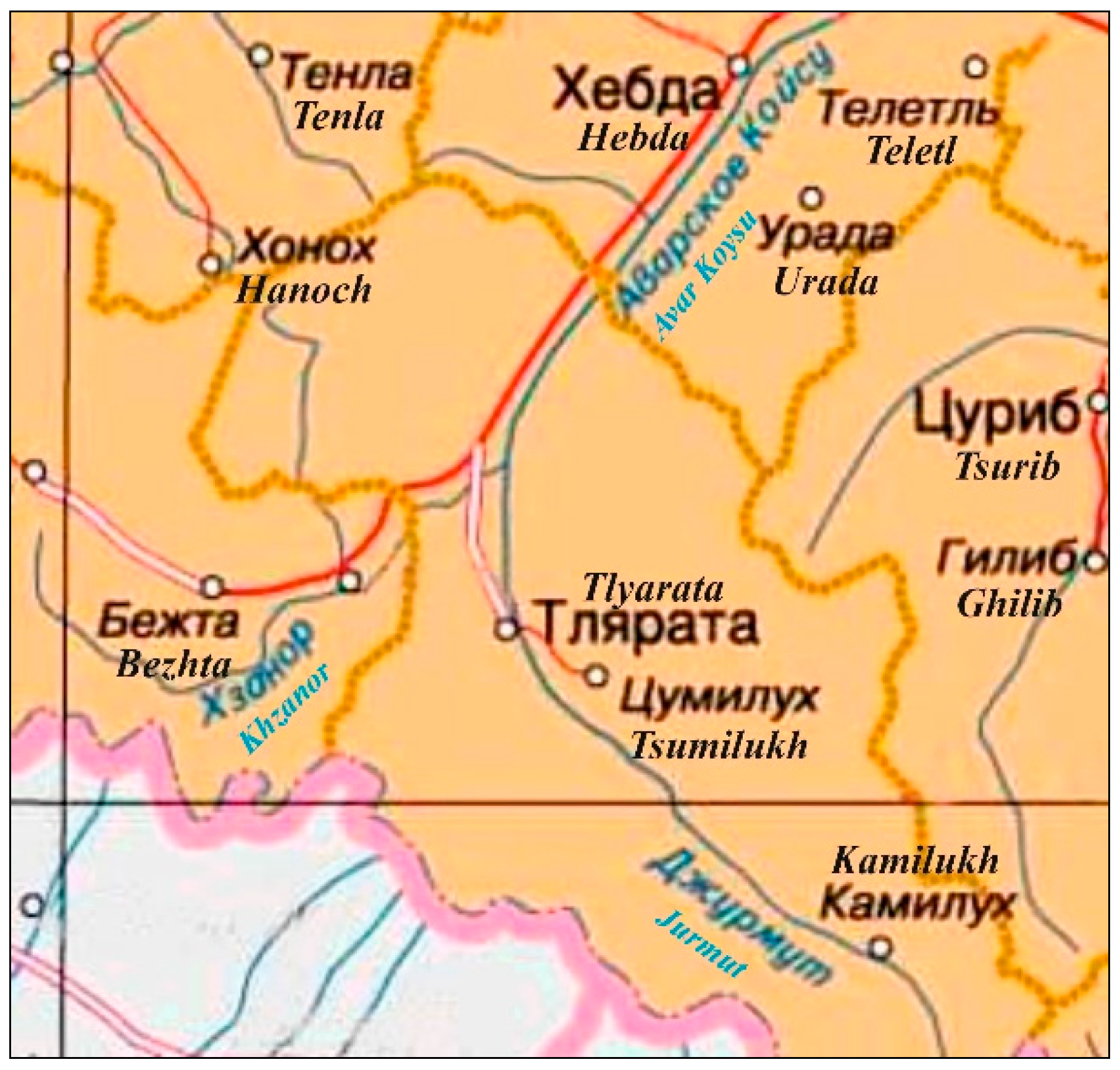
Figure 2.
Changes in the direction of winds at the Sulak-Vysokogornaya weather station over the past 60 years.
Figure 2.
Changes in the direction of winds at the Sulak-Vysokogornaya weather station over the past 60 years.
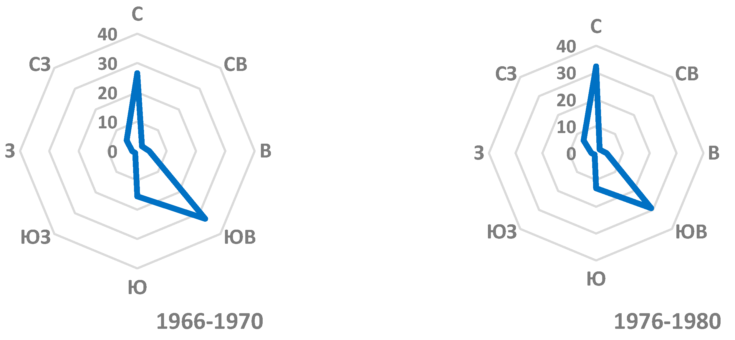

Figure 3.
Changes in the average annual air temperature at the Sulak-Vysokogornaya weather station over the past 60 years.
Figure 3.
Changes in the average annual air temperature at the Sulak-Vysokogornaya weather station over the past 60 years.
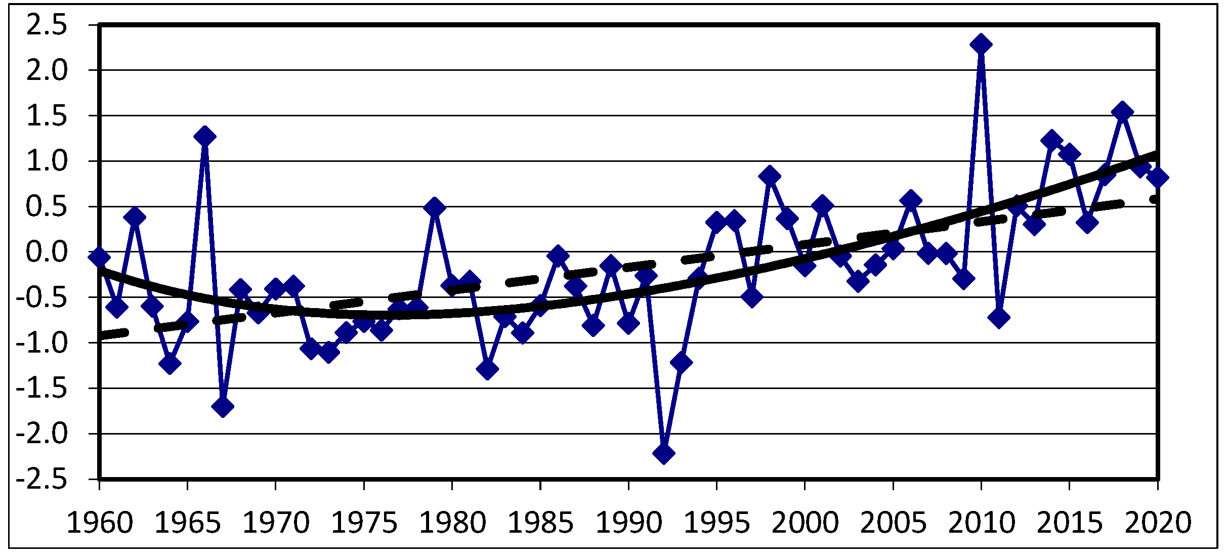
Figure 4.
Changes in annual precipitation at the Sulak-Vysokogornaya weather station over the past 60 years.
Figure 4.
Changes in annual precipitation at the Sulak-Vysokogornaya weather station over the past 60 years.
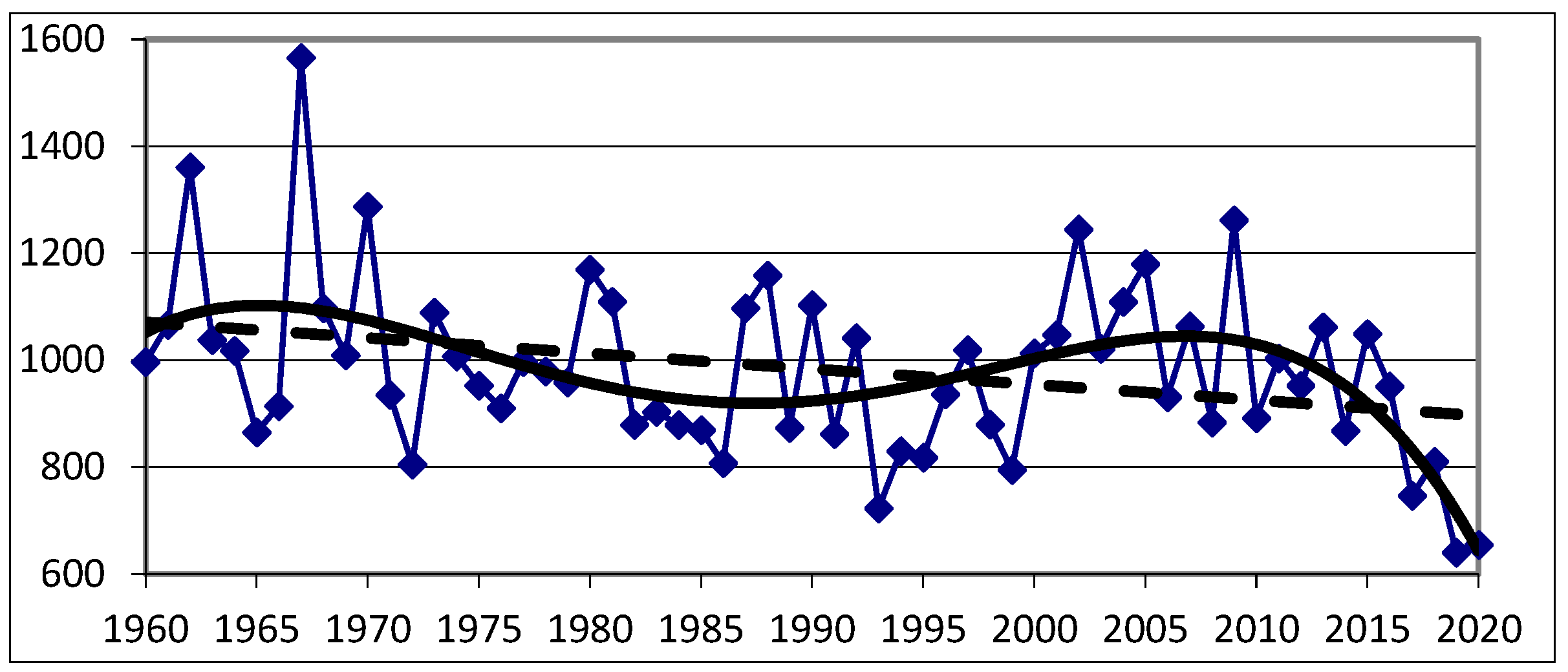
Figure 5.
Typical landslide slope.
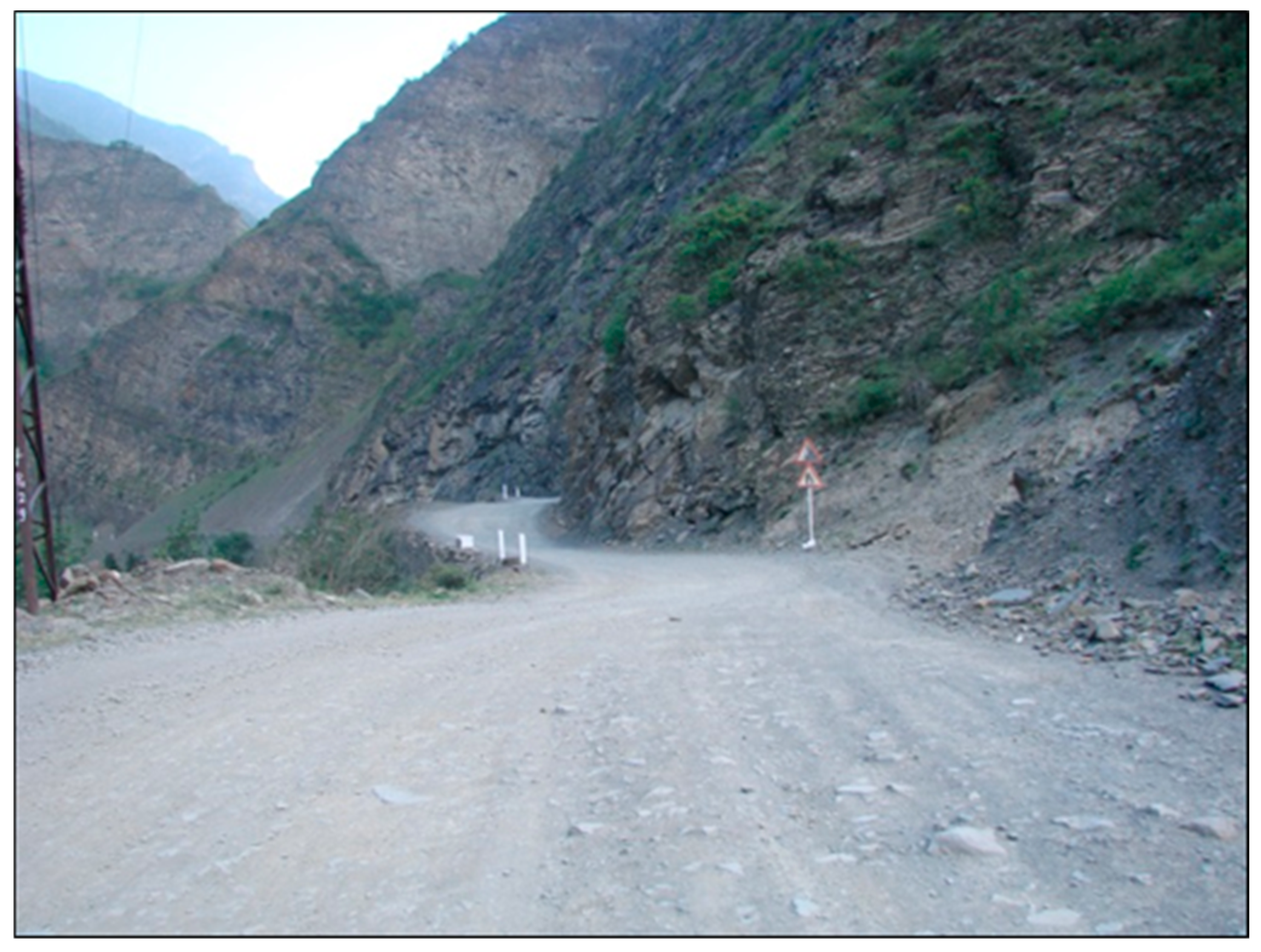
Figure 6.
Drilling of wells in the studied area.
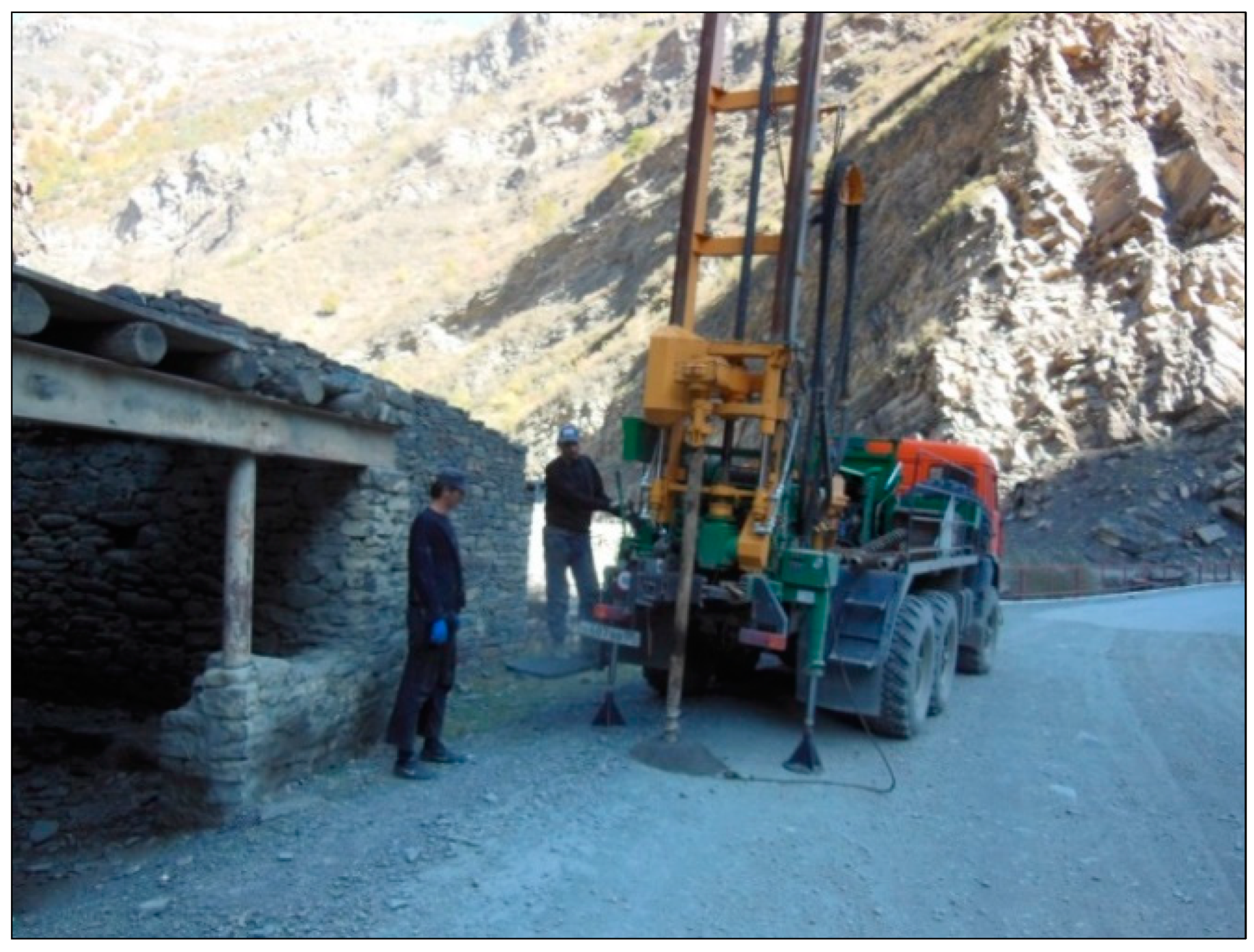
Figure 7.
Engineering and geological section along the profile of wells No. 40-45 along the highway.
Figure 7.
Engineering and geological section along the profile of wells No. 40-45 along the highway.

Figure 8.
Outcrop of mudstones of the Toar layer (J1t1+2).
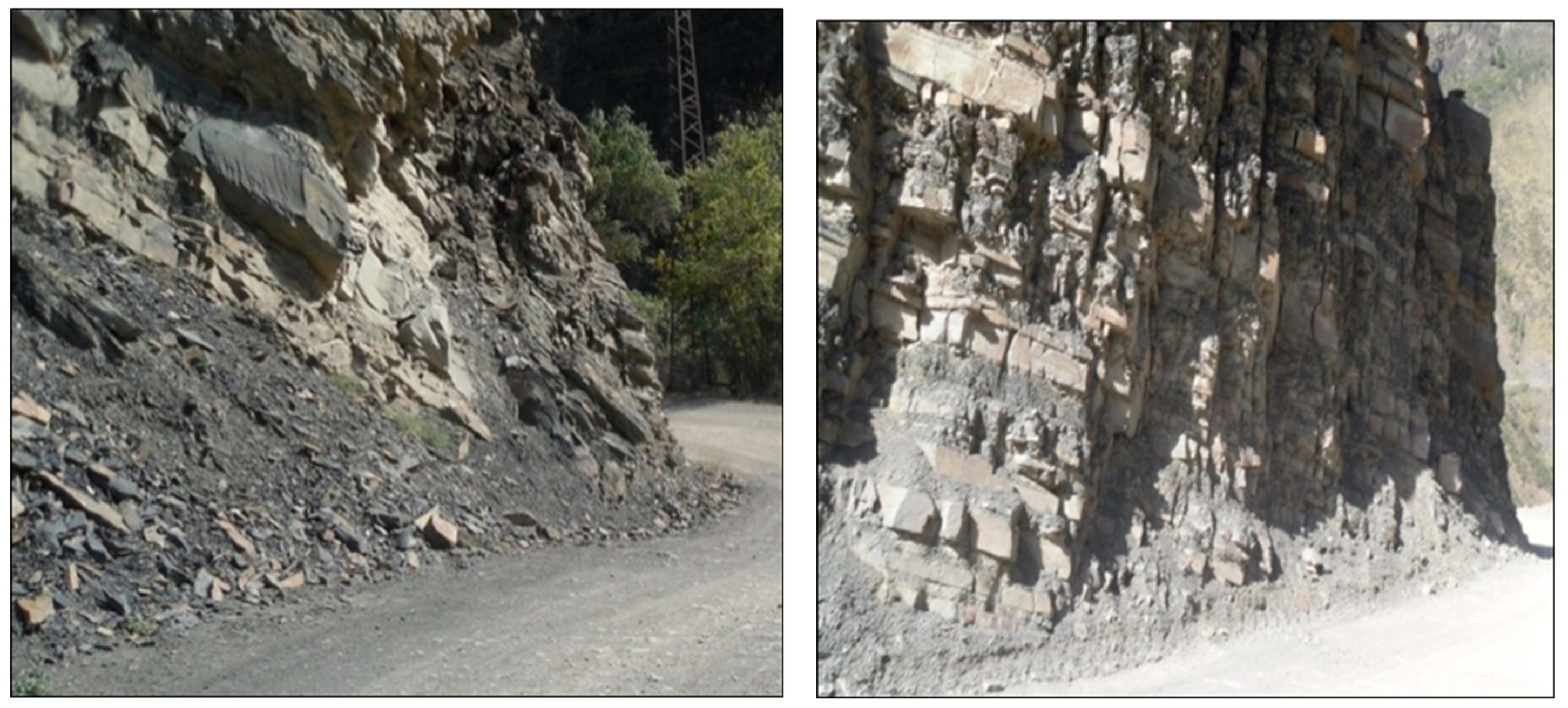
Figure 9.
The deployment of the braid on a typical site.
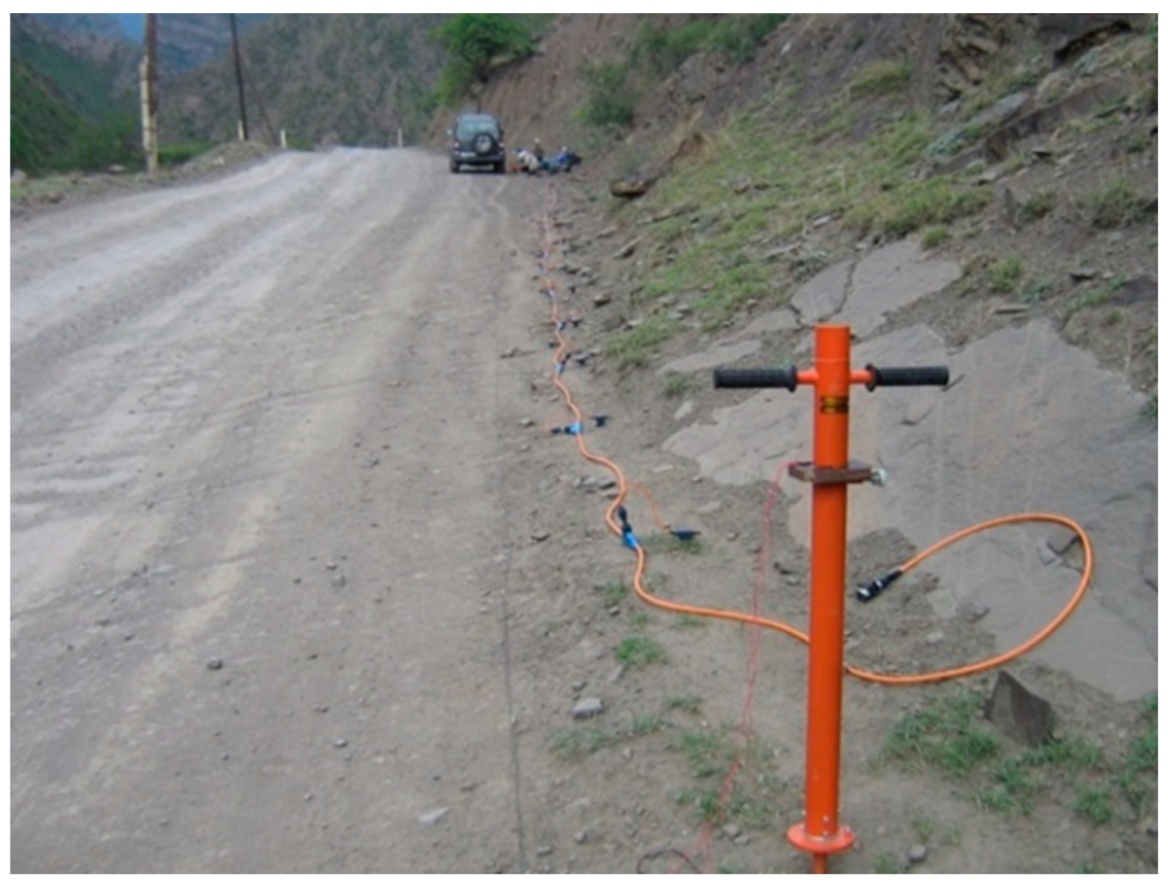
Figure 10.
Lithological and seismological sections of the studied area.


Table 1.
The main climatic parameters according to the data of the Tlyarata weather station.
| Name | The value of the parameter |
| Average annual air temperature, °С | 7,0 |
| Absolute maximum air temperature, °С | + 35 |
| Absolute minimum air temperature, | -22 |
| Air temperature of the coldest five-day period with probability of 0.98, °С | -17 |
| Air temperature of the coldest five-day period with probability of 0.92, °С | -14 |
| Average annual precipitation, mm | 621 |
| Average date of formation of stable snow cover | 13.XI |
| Average date of snow cover melting | 09.IV |
| The highest decadal height of the snow cover, cm | 33 |
| Average annual wind speed, m/s | 1,0 |
| Average number of fog days per year | 10 |
Table 2.
Analysis of the chemical composition of the water of the Avar Koisu and the Khzanor rivers.
Table 2.
Analysis of the chemical composition of the water of the Avar Koisu and the Khzanor rivers.
| №п/п | Name of chemical substances | Unit of measurement | Sanitary rules and regulations 21.4.1074-01 | Content of components, mg/dm3 | |||
| The Avar Koisu river | The Khzanor river | ||||||
| min. | мах. | min. | мах. | ||||
| 1 | Dry residue | mg/dm3 | 1000 (1500) | 190 | 248 | 214 | 312 |
| 2 | Total hardness | mg-eq/L | 7,0 (10) | 2,5 | 3 | 3,5 | 4,0 |
| 3 | Hydrogen index | pH | 6-9 | 7 | 8,7 | 7,2 | 8,7 |
| 4 | Oil products | mg/dm3 | 0,1 | 0 | 0,07 | 0 | 0,05 |
| 5 | Sulfates (SO4) | -«- | 500,0 | 72 | 120 | 48 | 96 |
| 6 | Chlorides (CI) | -«- | 350,0 | 7 | 14 | 7 | 14 |
| 7 | Nitrites (NO2) | -«- | 3 | 0,004 | 0,05 | 0 | 0,02 |
| 8 | Nitrates (NO3) | -«- | 45 | 0 | 1,0 | 0,1 | 2,1 |
| 9 | Ammonium (NH4) | -«- | 2 | 0,04 | 0,45 | 0,06 | 0,25 |
| 10 | Iron (Fe) | -«- | 0,3 (1,0) | 0,05 | 0,23 | 0,02 | 0,2 |
Table 3.
Micro-component composition of the water of the Avarskoye Koisu river.
| № | Name of chemical substances | Unit of measurement |
Sanitary rules and regulations 2.1.4.1074-01 |
Content of components, mg/dm3 |
| The Avar Koisu river | ||||
| 1 | Strontium | mg/dm3 | 7,0 | 2,1 |
| 2 | Silver (Ag) | -«- | 0,05 | 0,006 |
| 3 | Cadmium (Cd) | -«- | 0,001 | <0,001 |
| 4 | Cobalt (Co) | -«- | 0,1 | <0,005 |
| 5 | Nickel (Ni) | -«- | 0,1 | 0,004 |
| 6 | Chromium (Cr) | -«- | 0,05 | <0,005 |
| 7 | Copper (Cu) | -«- | 1,0 | 0,004 |
| 8 | Zinc (Zn) | -«- | 5,0 | 0,054 |
| 9 | Lead (Pb) | -«- | 0,03 | <0,005 |
| 10 | Manganese (Mn) | -«- | 0,1(0,5) | <0,002 |
| 11 | Boron (B) | -«- | 0,5 | 0,05 |
| 12 | Arsenic (As) | -«- | 0,05 | <0,002 |
| 13 | Mercury (Hg) | -«- | 0,0005 | <0,0005 |
| 14 | Selenium (Se) | -«- | 0,01 | <0,001 |
| 15 | Iodine (J) | -«- | - | <0,50 |
| 16 | Bromine (Br) | -«- | 0,2 | <0,20 |
| 17 | Fluoride (F) | -«- | 1,5 | <0,27 |
| 18 | Molybdenum (Mo) | -«- | 0,25 | 0,001 |
| 19 | Beryllium (Be) | -«- | 0,0002 | <0,0002 |
Table 4.
List of hazardous geological processes along the Hebda –Bezhta highway in the upper reaches of the Avar Koisu River.
Table 4.
List of hazardous geological processes along the Hebda –Bezhta highway in the upper reaches of the Avar Koisu River.
| Location (km +) | Length along the existing highway (m) | Maximum height (m) | Dimensions in plan | Size of the stone material (m) | Type of hazardous process | Note | |
| Beginning | The end | ||||||
| 62+510 | 62+570 | 60 | 150 | 200х60 | up to 3.5 | scree | current |
| 63+160 | 63+258 | 98 | 80 | 150х100 | up to 1,5 | scree, avalanche | -«- |
| 63+630 | 63+665 | 35 | 100 | 300х35 | up to 1,5 | scree | -«- |
| 63+810 | 63+845 | 35 | 280 | – | up to 1,0 | mudflow | -«- |
| 66+340 | 66+360 | 20 | 15 | 140х20 | up to 1,5 | scree, avalanche | -«- |
| 69+290 | 69+430 | 140 | 35 | 140х50 | up to 2,0 | scree | -«- |
| 69+625 | 69+750 | 125 | 20 | 125х65 | up to 2,0 | scree | -«- |
| 71+100 | 71+160 | 60 | 80 | 160х60 | up to 3,5 | scree, avalanche | -«- |
| 72+950 | 73+100 | 150 | 40 | 200х150 | up to 3,0 | scree | -«- |
| 74+100 | 74+155 | 55 | 25 | 60х40 | up to 1,0 | scree | -«- |
| 74+965 | 75+045 | 80 | 15 | 80х40 | up to 4,0 | scree | -«- |
| 75+300 | 75+330 | 30 | 15 | 50х30 | up to 1,5 | scree | -«- |
| 77+780 | 77+880 | 100 | 20 | 100х45 | up to 1,5 | scree, avalanche | -«- |
| 78+400 | 78+450 | 50 | 25 | 50х90 | up to 1,0 | scree | -«- |
| 81+150 | 81+220 | 70 | 30 | 70х100 | – | avalanche | -«- |
| 81+420 | 81+600 | 180 | 30 | 180х300 | up to 1,0 | scree, avalanche | -«- |
| 82+260 | 82+300 | 40 | 25 | 40х50 | up to 1,0 | scree | -«- |
| 82+360 | 82+400 | 40 | 20 | 40х80 | up to 1,0 | scree | -«- |
| 82+800 | 82+850 | 50 | 20 | 50х70 | up to 1,0 | scree | -«- |
| 88+400 | 88+420 | 20 | 30 | – | – | avalanche | -«- |
| 89+025 | 89+130 | 105 | 35 | 105х60 | up to 1,5 | scree | -«- |
| 90+800 | 90+875 | 75 | 40 | 75х60 | up to 1,5 | scree | -«- |
| 91+100 | 91+140 | 40 | 25 | 40х60 | up to 1,0 | scree | -«- |
| 91+300 | 91+340 | 40 | 30 | 40х70 | up to 2,0 | scree, avalanche | -«- |
| 93+200 | 93+220 | 20 | 10 | 20х20 | up to 1,0 | scree | -«- |
| 96+580 | 96+615 | 35 | 10 | 35х50 | up to 1,0 | scree | -«- |
| 97+555 | 97+600 | 45 | 25 | 45х55 | up to 1,0 | scree | -«- |
| 98+390 | 98+410 | 20 | 15 | 20х10 | up to 1,0 | scree | -«- |
| 100+340 | 100+370 | 30 | 20 | 30х120 | up to 2,0 | scree | -«- |
| 100+520 | 100+540 | 20 | 20 | – | up to 1,0 | scree, mudflow | -«- |
| 100+750 | 100+780 | 30 | 10 | 30х40 | up to 1,0 | scree | -«- |
| 100+860 | 100+935 | 75 | 25 | 75х120 | up to 2,0 | scree | -«- |
| 101+500 | 101+550 | 50 | 15 | 50х30 | up to 1,0 | scree | -«- |
| 102+250 | 102+280 | 30 | 20 | 30х50 | up to 1,0 | scree | -«- |
| 104+250 | 104+270 | 30 | 20 | 30х50 | up to 1,0 | scree | -«- |
| 107+700 | 107+730 | 30 | 20 | 30х50 | up to 1,0 | scree | -«- |
| 109+980 | 110+040 | 60 | 10 | 60х10 | up to 1,0 | scree | -«- |
| 110+430 | 110+450 | 20 | 40 | – | – | mudflow | -«- |
| 111+000 | 111+010 | 10 | 15 | 10х25 | up to 1,0 | scree | -«- |
| 113+105 | 113+225 | 120 | 15 | 120х40 | up to 1,5 | scree | -«- |
| 113+240 | 113+260 | 20 | 80 | – | up to 1,0 | scree, mudflow | -«- |
| 113+750 | 113+800 | 50 | 15 | 50х20 | up to 1,0 | scree | -«- |
| 114+200 | 114+400 | 200 | 50 | 200х75 | – | landslide | -«- |
| 116+510 | 116+610 | 100 | 20 | 100х60 | up to 2,0 | scree | -«- |
| 116+750 | 116+770 | 20 | 20 | 20х25 | up to 1,0 | scree | -«- |
| 117+145 | 117+220 | 75 | 35 | 75х90 | up to 1,0 | scree | -«- |
| 117+800 | 117+865 | 65 | 25 | 65х50 | up to 1,5 | scree | -«- |
| 118+100 | 118+340 | 240 | 15 | 240х55 | up to 2,0 | scree | -«- |
| 119+615 | 119+660 | 45 | 20 | 45х25 | up to 2,5 | scree | -«- |
| 119+710 | 119+735 | 25 | 40 | 25х90 | up to 2,0 | scree | -«- |
| 121+430 | 121+450 | 20 | 15 | 20х35 | up to 2,0 | scree | -«- |
| 121+820 | 121+840 | 20 | 10 | 20х40 | up to 1,5 | scree | -«- |
| 122+040 | 122+200 | 160 | 40 | 120х85 | – | landslide | -«- |
| 122+240 | 122+300 | 60 | 15 | 60х75 | up to 2,0 | scree | -«- |
| 122+410 | 122+540 | 130 | 40 | 130х30 | up to 3,5 | scree, avalanche | -«- |
| 122+835 | 122+985 | 150 | 25 | 150х75 | up to 6,0 | scree | -«- |
| 123+630 | 123+720 | 90 | 15 | 90х85 | up to 4,0 | scree | -«- |
| 124+090 | 124+135 | 45 | 10 | 45х60 | up to 5,0 | scree | -«- |
| 124+630 | 124+645 | 15 | 15 | 15х25 | up to 1,5 | scree | -«- |
| 124+690 | 124+700 | 10 | 80 | – | – | mudflow | -«- |
| 125+090 | 125+160 | 70 | 30 | 70х20 | up to 1,5 | scree | -«- |
| 125+415 | 125+430 | 15 | 20 | 15х25 | up to 1,0 | scree | -«- |
| 125+850 | 125+875 | 25 | 20 | 25х40 | up to 1,0 | scree | -«- |
| 127+860 | 127+880 | 20 | 10 | 20х35 | up to 1,0 | scree | -«- |
Disclaimer/Publisher’s Note: The statements, opinions and data contained in all publications are solely those of the individual author(s) and contributor(s) and not of MDPI and/or the editor(s). MDPI and/or the editor(s) disclaim responsibility for any injury to people or property resulting from any ideas, methods, instructions or products referred to in the content. |
© 2024 by the authors. Licensee MDPI, Basel, Switzerland. This article is an open access article distributed under the terms and conditions of the Creative Commons Attribution (CC BY) license (http://creativecommons.org/licenses/by/4.0/).
Copyright: This open access article is published under a Creative Commons CC BY 4.0 license, which permit the free download, distribution, and reuse, provided that the author and preprint are cited in any reuse.


