Submitted:
14 November 2024
Posted:
18 November 2024
You are already at the latest version
Abstract
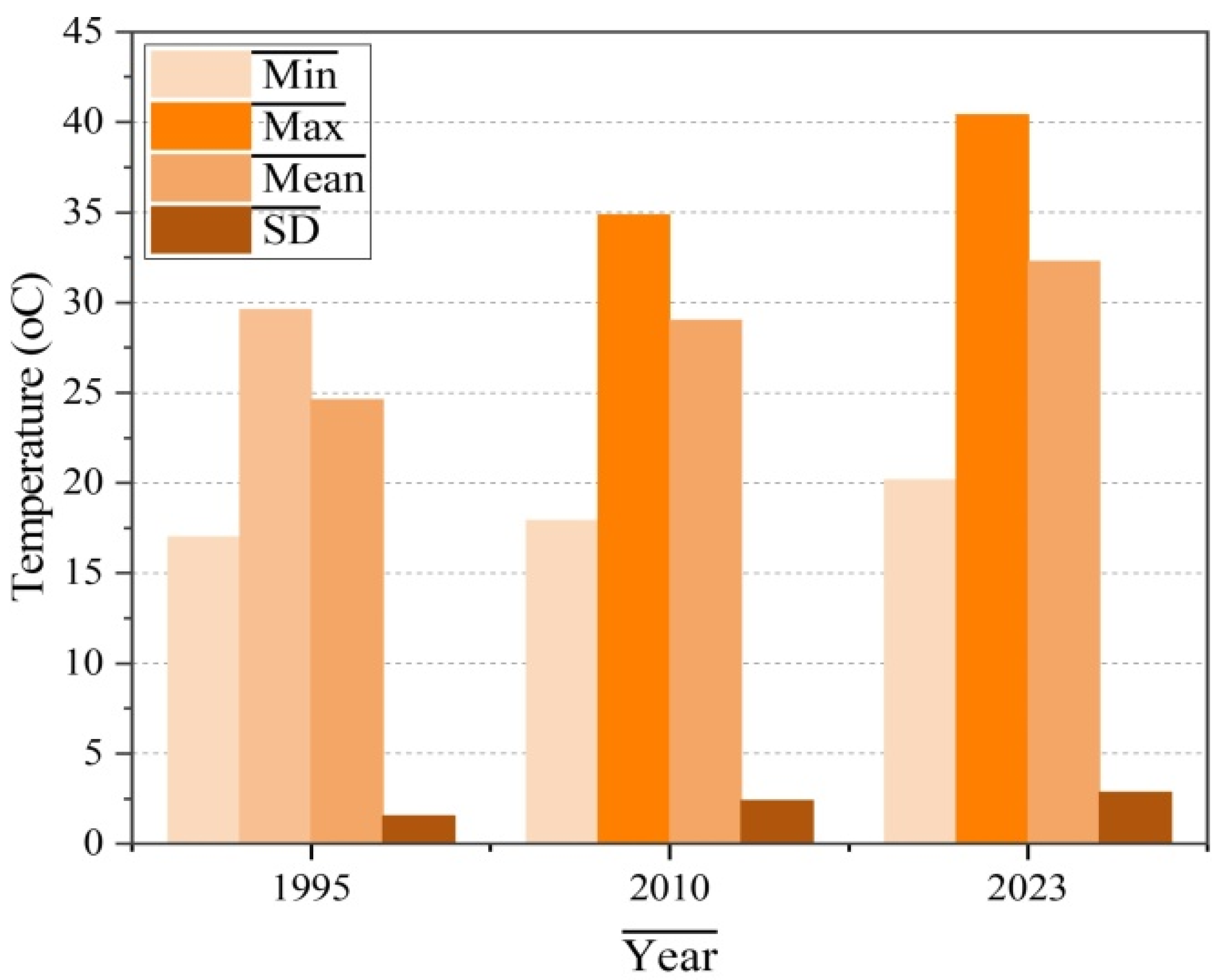
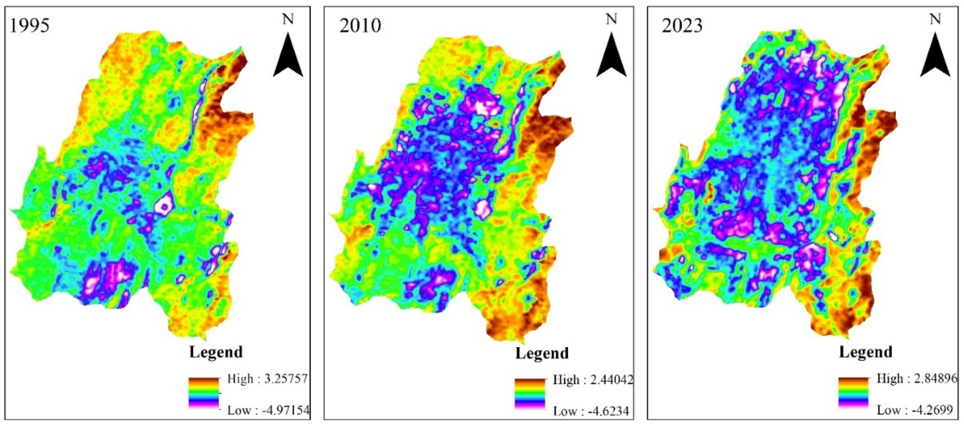
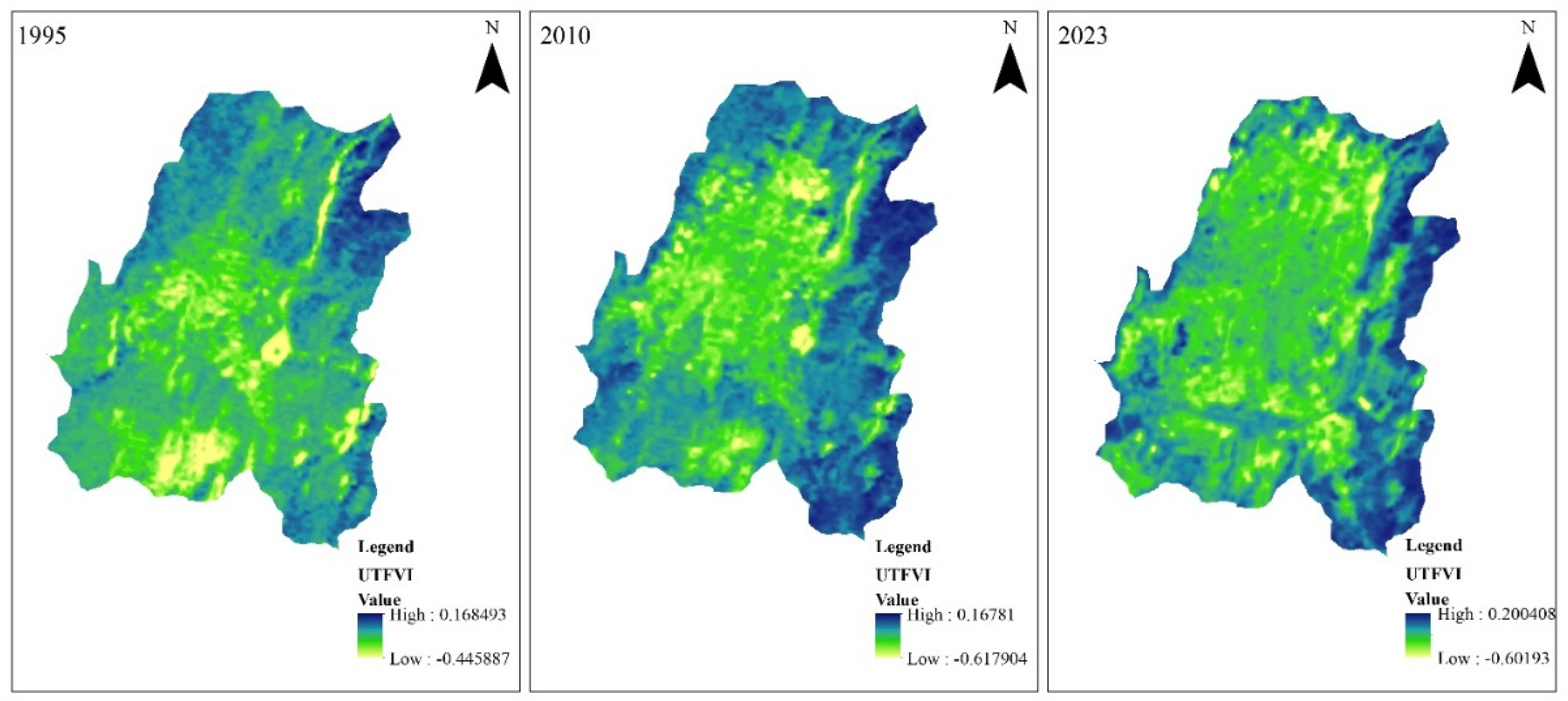
The urban environments are facing a rapid thermal increase and heat-related stresses driven by an interplay of several factors. To address these challenges, it is crucial to identify space-time thermal state fluctuations of an urban area. The objective of this study is to explore the long-term variation in the thermal state of Adama City, Ethiopia. The study utilized multi-temporal Landsat imagery and QGIS workspace and employed a Mono-window algorithm for Land Surface Temperature (LST) retrieval. The minimum, maximum, and mean LST of the city increased by 0.91, 5.26, and 4.4oc from 1995 to 2010 and 2.23, 6.08, and 3.28oc from 2010 to 2023. The highest urban heat island (UHI) value was 3.25°C in 1995; it varied to 2.44°C in 2010 and 2.84°C in 2023. Furthermore, in 1995, 2010, and 2023, the minimum UHI values were -4.9°C, -4.6°C, and -4.26°C, respectively. The maximum, minimum, and average values of urban thermal field variance (UTFVI) increased from 1995 (0.1685, -0.44588, -0.00368) to 2010 (0.1678, -0.6179, -0.08533) and 2023 (0.20, -0.601, -0.00765). The findings give an overall conclusion that Adama City’s thermal state levels have fluctuated and escalated significantly over time. The study findings emphasize the relevance of increased green areas-focused urban planning to achieve sustainable urban development and SDG-11.
Keywords:
1. Introduction
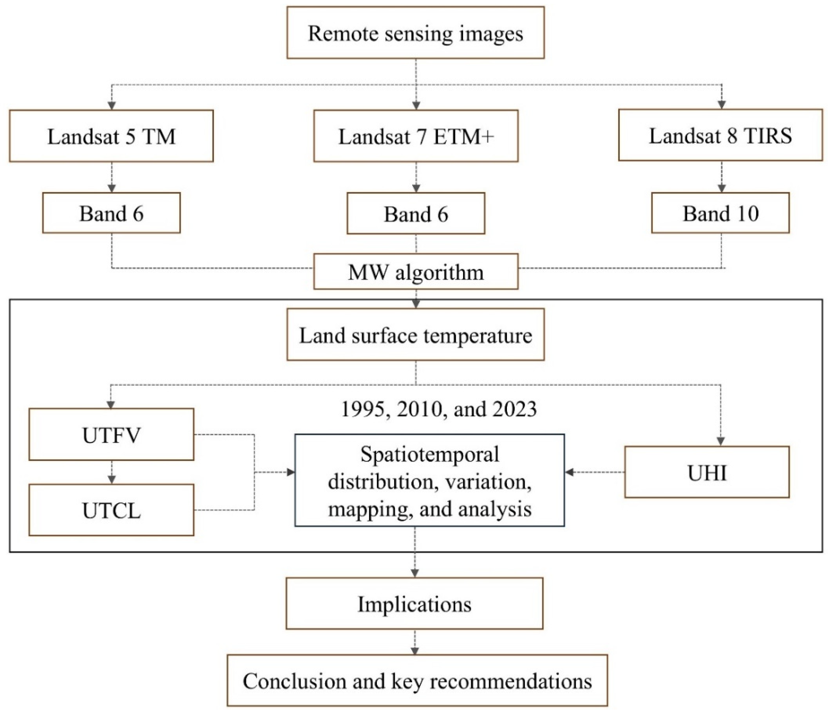
2. Materials and Methods
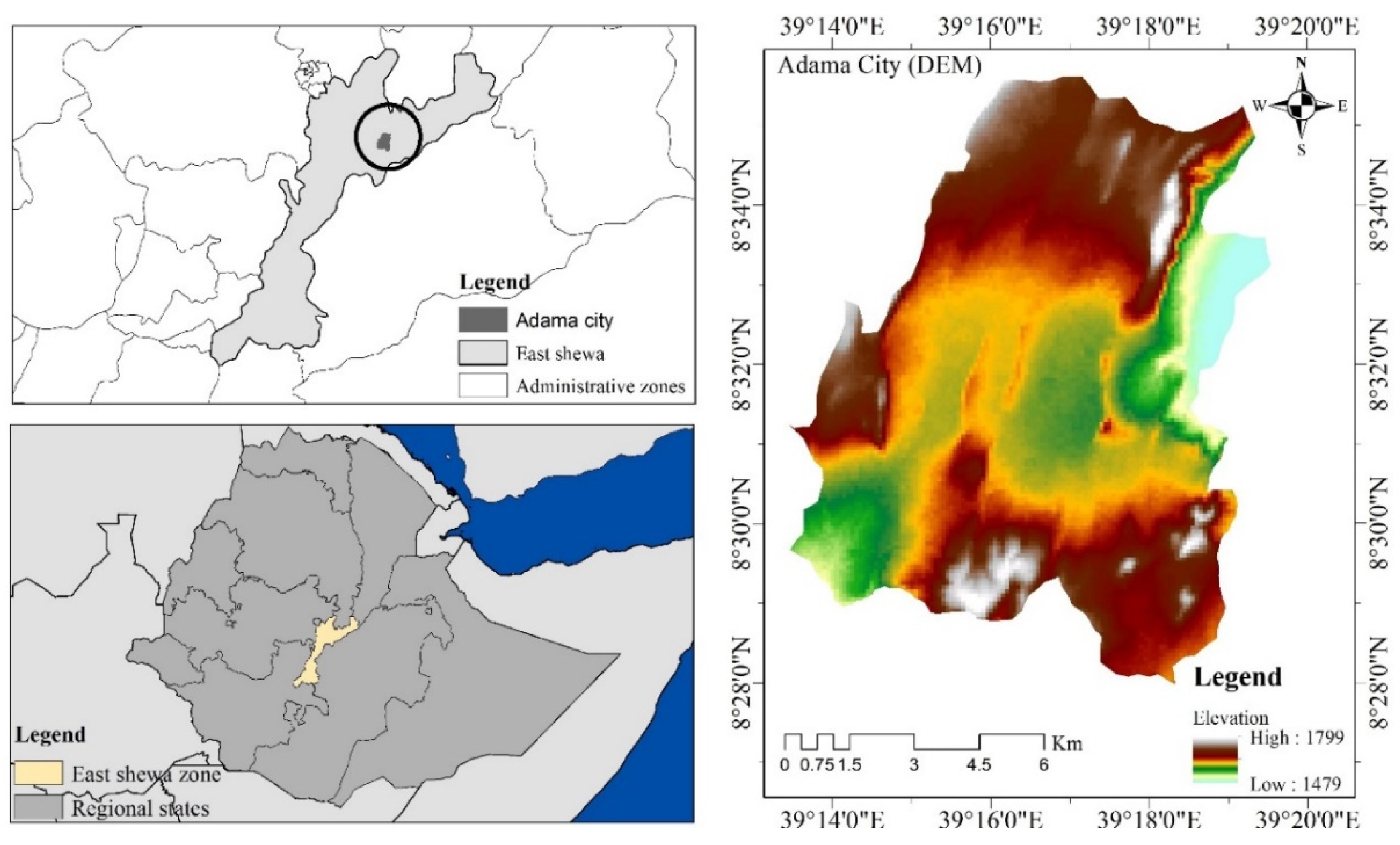
2.1. Study Area Description
2.2. Data Description
2.3. Urban Thermal Environment Change Simulation
2.3.1. Land Surface Temperature Generation
2.5.2. UHI Change Assessment
2.5.3. Urban Thermal Field Variance and Comfort Level

| UTFVI value | <0 | 0-0.005 | 0.005-0.01 | 0.01-0.015 | 0.015-0.02 | >0.020 |
|---|---|---|---|---|---|---|
| Comfort level | None | Low | Middle | High | Very high | sever |
| UHI threshold | Excellent | Good | Normal | Bad | Worse | Worst |
3.5. Limitations and Future Research Work
3. Result and Discussion
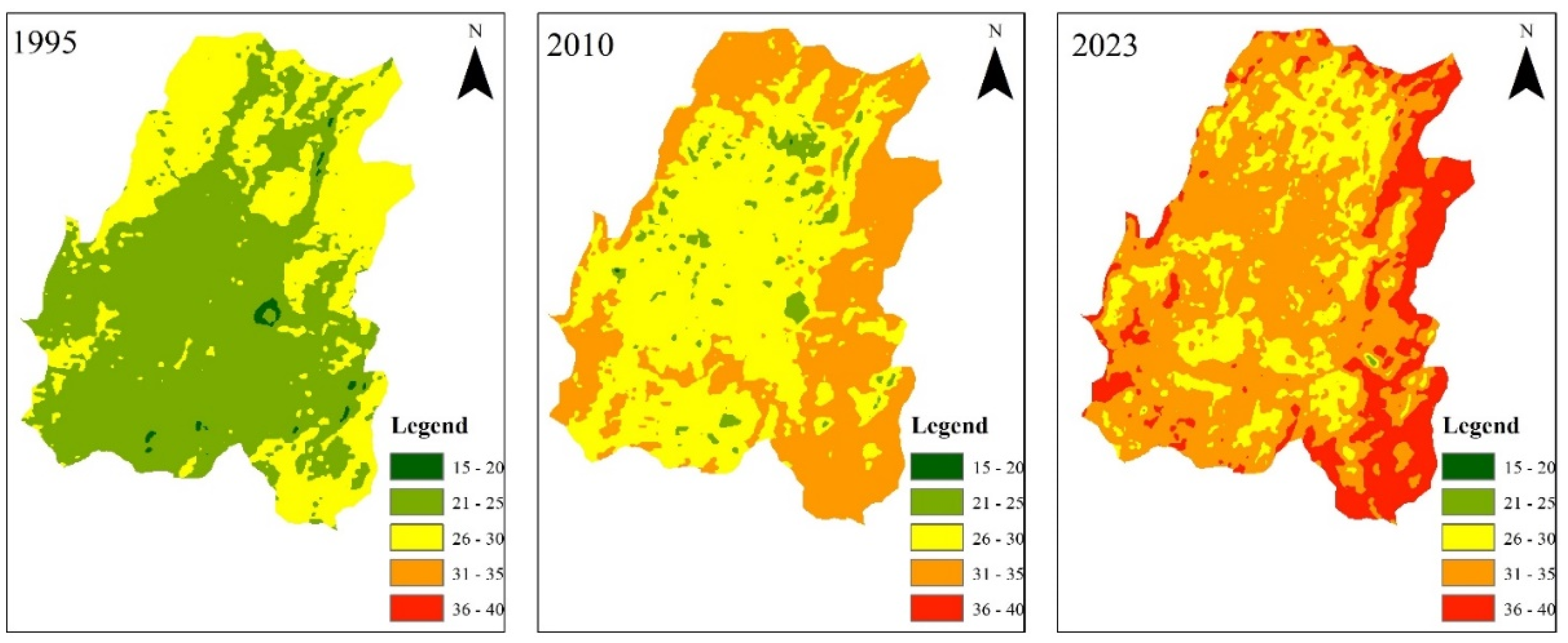
3.1. LST Construction
| Range | 2023 | 2010 | 1995 | |||
|---|---|---|---|---|---|---|
| Area(ha) | Percentage (%) | Area(ha) | Percentage (%) | Area(ha) | Percentage (%) | |
| Very low | 0 | 0 | 1.89 | 0.018820408 | 64.26 | 0.639893889 |
| Low | 6.75 | 0.067215745 | 408.87 | 4.071481704 | 6403.14 | 63.76175155 |
| Moderate | 2176.83 | 21.67662953 | 5363.1 | 53.40514962 | 3574.89 | 35.59835456 |
| High | 5876.82 | 58.52071589 | 4268.43 | 42.50454827 | 0 | 0 |
| Very high | 1981.89 | 19.73543883 | 0 | 0 | 0 | 0 |
3.2. Spatiotemporal Variation of UHI
3.3. UTFV and Urban Thermal Comfort Level
| UTFVI value | <0 | 0-0.005 | 0.005-0.01 | 0.01-0.015 | 0.015-0.02 | >0.020 | Total | |
|---|---|---|---|---|---|---|---|---|
| Comfort level | None | Low | Middle | High | Very high | Severe | ||
| 1995 | Area (ha) | 5104.26 | 0 | 0 | 1362.96 | 0 | 3574.44 | 10041.66 |
| Percentage | 50.8308387 | 0 | 0 | 13.573055 | 0 | 35.596107 | 100 | |
| 2010 | Area (ha) | 4650.93 | 0 | 551.7 | 0 | 571.77 | 4267.26 | 10041.66 |
| Percentage | 46.3163461 | 0 | 5.4941115 | 0 | 5.6939789 | 42.495563 | 100 | |
| 2023 | Area (ha) | 3731.67 | 156.24 | 153.72 | 160.74 | 160.92 | 5678.37 | 10041.66 |
| Percentage | 37.1618836 | 1.555918 | 1.5308226 | 1.6007314 | 1.6025239 | 56.548121 | 100 | |
3.3. Comparison with Other Studies
3.4. Implications for Sustainable Urban Environment
4. Conclusions and Key Recommendation
Author Contributions
Funding
Data Availability Statement
Conflicts of Interest
References
- Aghamolaei, R., Azizi, M. M., Aminzadeh, B., & O’Donnell, J. (2023). A comprehensive review of outdoor thermal comfort in urban areas: Effective parameters and approaches. Energy and Environment, 34(6), 2204–2227. [CrossRef]
- Balew, A., & Korme, T. (2020). The Egyptian Journal of Remote Sensing and Space Sciences Monitoring land surface temperature in Bahir Dar city and its surroundings using Landsat images. The Egyptian Journal of Remote Sensing and Space Sciences, 23(3), 371–386. [CrossRef]
- Briciu, A. E., Mihaila, D., Graur, A., Oprea, D. I., Prisacariu, A., & Bistricean, P. I. (2020). Changes in the water temperature of rivers impacted by the urban heat island: Case study of Suceava city. Water (Switzerland), 12(5). [CrossRef]
- Bulti, D. T., & Abebe, B. G. (2020). Analyzing the impacts of urbanization on runoff characteristics in Adama city, Ethiopia. SN Applied Sciences, 2(7), 1–13. [CrossRef]
- Bulti, D. T., & Assefa, T. (2019). Analyzing ecological footprint of residential building construction in Adama City, Ethiopia. Environmental Systems Research, 8(1). [CrossRef]
- Choudhury, U., Singh, S. K., Kumar, A., Meraj, G., Kumar, P., & Kanga, S. (2023). Assessing Land Use/Land Cover Changes and Urban Heat Island Intensification: A Case Study of Kamrup Metropolitan District, Northeast India (2000–2032). Earth (Switzerland), 4(3), 503–521. [CrossRef]
- Clark, D. B., Xue, Y., Harding, R. J., & Valdes, P. J. (2001). Modeling the impact of land surface degradation on the climate of tropical North Africa. Journal of Climate, 14(8), 1809–1822. [CrossRef]
- Crétat, J., Richard, Y., Pohl, B., Emery, J., Dudek, J., Roy, D., Pergaud, J., Rega, M., Poupelin, M., Joly, D., Thévenin, T., Marquès, E., & Masson, V. (2024). Impact of topography and land cover on air temperature space-time variability in an urban environment with contrasted topography (Dijon, France, 2014–2021). Theoretical and Applied Climatology, 155(3), 1941–1958. [CrossRef]
- Das, N., Mondal, P., Sutradhar, S., & Ghosh, R. (2021). Assessment of variation of land use/land cover and its impact on land surface temperature of Asansol subdivision. Egyptian Journal of Remote Sensing and Space Science, 24(1), 131–149. [CrossRef]
- Degefu, M. A., Argaw, M., Feyisa, G. L., & Degefa, S. (2023). Dynamics of green spaces- Land surface temperature intensity nexus in cities of Ethiopia. Heliyon, 9(2), e13274. [CrossRef]
- Dibaba, W. T. (2023). Urbanization-induced land use/land cover change and its impact on surface temperature and heat fluxes over two major cities in Western Ethiopia. Environmental Monitoring and Assessment, 195(9), 1–20. [CrossRef]
- Eshetie, S. M. (2024). Exploring urban land surface temperature using spatial modeling techniques: a case study of Addis Ababa city, Ethiopia. Scientific Reports, 1–16. [CrossRef]
- Fonseka, P., Marasinghe, S., & Rila, M. (2022). Impact of urban induced heat on the lightning activity of Srilanka: Colombo and suburbs. 43rd Asian Conference on Remote Sensing, ACRS 2022, 10–12.
- García, D. H. (2022). Analysis of Urban Heat Island and Heat Waves Using Sentinel-3 Images: a Study of Andalusian Cities in Spain. Earth Systems and Environment, 6(1), 199–219. [CrossRef]
- García, D. H., & Díaz, J. A. (2023). Space-time analysis of the earth’s surface temperature, surface urban heat island and urban hotspot: relationships with a variation of the thermal field in Andalusia (Spain). Urban Ecosystems, 26(2), 525–546. [CrossRef]
- Gebreselassie, T. A., & Rao, P. P. J. (2021). Geospatial Location Based Study for Establishment of New Public Health Centers: A Case of Adama City, Oromia, Ethiopia. International Journal of Recent Technology and Engineering (IJRTE), 10(3), 221–230. [CrossRef]
- Ghribi, M., & Dahech, S. (2023). The Impact of the Urban Heat Island on the Sensation of Thermal Comfort and Electricity Consumption in Sfax in Central-Eastern Tunisia during the Hot Season. Energies, 16(2). [CrossRef]
- Gök, D. T., Scherler, D., & Wulf, H. (2024). Land surface temperature trends derived from Landsat imagery in the Swiss Alps. May, 1–29.
- Hamed Fahmy, A., Amin Abdelfatah, M., & El-Fiky, G. (2023). Investigating land use land cover changes and their effects on land surface temperature and urban heat islands in Sharqiyah Governorate, Egypt. Egyptian Journal of Remote Sensing and Space Science, 26(2), 293–306. [CrossRef]
- Husain, A., Kumar, P., & Gonencgil, B. (2023). Assessment of Spatio-Temporal Land Use/Cover Change and Its Effect on Land Surface Temperature in Lahaul and Spiti, India. 1–20.
- Kalogeropoulos, G., Dimoudi, A., Toumboulidis, P., & Zoras, S. (2022). Urban Heat Island and Thermal Comfort Assessment in a Medium-Sized Mediterranean City. Atmosphere, 13(7). [CrossRef]
- Kanga, S., Meraj, G., Johnson, B. A., Singh, S. K., PV, M. N., Farooq, M., Kumar, P., Marazi, A., & Sahu, N. (2022). Understanding the Linkage between Urban Growth and Land Surface Temperature—A Case Study of Bangalore City, India. Remote Sensing, 14(17). [CrossRef]
- Kikon, N., Singh, P., Singh, S. K., & Vyas, A. (2016). Assessment of urban heat islands (UHI) of Noida City, India using multi-temporal satellite data. Sustainable Cities and Society, 22, 19–28. [CrossRef]
- Kumar, A., Agarwal, V., Pal, L., Chandniha, S. K., & Mishra, V. (2021). Effect of Land Surface Temperature on Urban Heat Island in Varanasi City, India. J, 4(3), 420–429. [CrossRef]
- Li, Jackson, T. J., Kustas, W. P., Schmugge, T. J., French, A. N., Cosh, M. H., & Bindlish, R. (2004). Deriving land surface temperature from Landsat 5 and 7 during SMEX02/SMACEX. Remote Sensing of Environment, 92(4), 521–534. [CrossRef]
- Li, X., Stringer, L. C., & Dallimer, M. (2021). The spatial and temporal characteristics of urban heat island intensity: Implications for East Africa’s urban development. Climate, 9(4). [CrossRef]
- Li, Z., Wu, H., Duan, S., Zhao, W., Ren, H., & Liu, X. (2022). Satellite Remote Sensing of Global Land Surface Temperature: Definition, Methods, Products, and Applications Reviews of Geophysics. [CrossRef]
- Lu, Y., Feng, X., Xiao, P., Shen, C., & Sun, J. (2009). Urban heat island in the summer of Nanjing based on TM data. 2009 Joint Urban Remote Sensing Event, June 2009. [CrossRef]
- Moisa, M. B., Dejene, I. N., Roba, Z. R., & Gemeda, D. O. (2022). Impact of urban land use and land cover change on urban heat island and urban thermal comfort level: a case study of Addis Ababa City, Ethiopia. Environmental Monitoring and Assessment, 194(10). [CrossRef]
- Moisa, M. B., & Gemeda, D. O. (2022). Assessment of urban thermal field variance index and thermal comfort level of Addis Ababa metropolitan city, Ethiopia. Heliyon, 8(8), e10185. [CrossRef]
- Mustafa, E. K., Co, Y., Liu, G., Kaloop, M. R., Beshr, A. A., Zarzoura, F., & Sadek, M. (2020). Study for Predicting Land Surface Temperature ( LST ) Using Landsat Data: A Comparison of Four Algorithms. 2020.
- Mwangi, P. W., Karanja, F. N., & Kamau, P. K. (2018). Analysis of the Relationship between Land Surface Temperature and Vegetation and Built-Up Indices in Upper-Hill, Nairobi. Journal of Geoscience and Environment Protection, 06(01), 1–16. [CrossRef]
- Nasar-u-minallah, M. (2018). Spatial and Temporal Change Assessment in Land Surface Temperature of Lahore using GIS and Remote Sensing Techniques. 55(April), 67–76.
- Negesse, M. D., Hishe, S., & Getahun, K. (2024). Urban land use, land cover change, and urban microclimate dynamics. Discover Environment. [CrossRef]
- Ogunode, A., & Akombelwa, M. (2017). An algorithm to retrieve Land Surface Temperature using Landsat-8 Dataset. 6(2), 262–276.
- Pantavou, K., Kotroni, V., & Lagouvardos, K. (2024). Thermal environment and indices: an analysis for effectiveness in operational weather applications in a Mediterranean city (Athens, Greece). International Journal of Biometeorology, 68(1), 79–87. [CrossRef]
- Regassa, B., Kassaw, M., & Bagyaraj, M. (2020). Analysis of Urban Expansion and Modeling of LULC Changes Using Geospatial Techniques: The Case of Adama City. Remote Sensing of Land, 4(1–2), 40–58. [CrossRef]
- Ren, J., Shi, K., Li, Z., Kong, X., & Zhou, H. (2023). A Review on the Impacts of Urban Heat Islands on Outdoor Thermal Comfort. Buildings, 13(6). [CrossRef]
- Rendana, M., Idris, W. M. R., Rahim, S. A., Abdo, H. G., Almohamad, H., Al Dughairi, A. A., & Al-Mutiry, M. (2023). Relationships between land use types and urban heat island intensity in Hulu Langat district, Selangor, Malaysia. Ecological Processes, 12(1). [CrossRef]
- Shahfahad, Talukdar, S., Rihan, M., Hang, H. T., Bhaskaran, S., & Rahman, A. (2022). Modeling urban heat island (UHI) and thermal field variation and their relationship with land use indices over Delhi and Mumbai metro cities. Environment, Development and Sustainability, 24(3), 3762–3790. [CrossRef]
- Subramanian, D. (2023). Quantifying thermal variation around gray infrastructure in urban India. Frontiers in Water, 5. [CrossRef]
- Tesfamariam, S., Govindu, V., & Uncha, A. (2023). Spatio-temporal analysis of urban heat island (UHI) and its effect on urban ecology: The case of Mekelle city, Northern Ethiopia. Heliyon, 9(2), e13098. [CrossRef]
- Tong, S., Prior, J., McGregor, G., Shi, X., & Kinney, P. (2021). Urban heat: An increasing threat to global health. The BMJ, 375, 1–5. [CrossRef]
- Twumasi, Y. A., Merem, E. C., Namwamba, J. B., Mwakimi, O. S., Ayala-silva, T., Frimpong, D. B., Ning, Z. H., Asare-ansah, A. B., Annan, J. B., Oppong, J., Loh, P. M., Owusu, F., Jeruto, V., Petja, B. M., Okwemba, R., Mcclendon-peralta, J., Akinrinwoye, C. O., & Mosby, H. J. (2021). Estimation of Land Surface Temperature from Landsat-8 OLI Thermal Infrared Satellite Data. A Comparative Analysis of Two Cities in Ghana. 131–149. [CrossRef]
- Ullah, N., Siddique, M. A., Ding, M., Grigoryan, S., Zhang, T., & Hu, Y. (2022). Spatiotemporal Impact of Urbanization on Urban Heat Island and Urban Thermal Field Variance Index of Tianjin City, China. Buildings, 12(4), 21–23. [CrossRef]
- UN. (2018). Around 2.5 billion more people will be living in cities by 2050, projects a new UN report. United Nations. Available online: https://www.Un.Org/En/Desa/around-25-Billionmore-People-Will-Be-Living-Cities-2050-Projects-New-Un-Report.
- Woldesemayat, E. M., & Genovese, P. V. (2021). Monitoring urban expansion and urban green spaces change in Addis Ababa: Directional and zonal analysis integrated with landscape expansion index. Forests, 12(4), 1–19. [CrossRef]
- Yang, L., Qian, F., Song, D. X., & Zheng, K. J. (2016). Research on Urban Heat-Island Effect. Procedia Engineering, 169, 11–18. [CrossRef]
- You, G. J., & Ringler, C. (2013). Hydro-economic modeling of climate change impacts in Ethiopia IFPRI Discussion Paper 00960 Hydro-Economic Modeling of Climate Change Impacts in Ethiopia Gene Jiing-Yun You Environment and Production Technology Division. January 2010.
- Zhan, D., Sezer, N., Hou, D., Wang, L., & Hassan, I. G. (2023). Integrating Urban Heat Island Impact into Building Energy Assessment in a Hot-Arid City. Buildings, 13(7). [CrossRef]
| Data type/sensor | Date of acquisition | Resolution | Year | Source |
|---|---|---|---|---|
| RS/Landsat 5 TM | 24/07/2024 | 30m 30m | 1995 | USGS |
| RS/Landsat 7 ETM+ | 25/07/2024 | 30m 30m | 2010 | USGS |
| RS/Landsat 8 TRS | 24/07/2024 | 30m 30m | 2023 | USGS |
| Shapefile | 03/06/2024 | 1:400,000 | - | Adama city administration |
Disclaimer/Publisher’s Note: The statements, opinions and data contained in all publications are solely those of the individual author(s) and contributor(s) and not of MDPI and/or the editor(s). MDPI and/or the editor(s) disclaim responsibility for any injury to people or property resulting from any ideas, methods, instructions or products referred to in the content. |
© 2024 by the author. Licensee MDPI, Basel, Switzerland. This article is an open access article distributed under the terms and conditions of the Creative Commons Attribution (CC BY) license (https://creativecommons.org/licenses/by/4.0/).


