
Submitted:
12 November 2024
Posted:
12 November 2024
You are already at the latest version
Abstract
The Jinshajiang fault zone is the western boundary fault of the Sichuan–Yunnan block, located east of the Qinghai–Tibetan Plateau. It is a complex tectonic suture belt with multi-phase activity and is characterized by multiple sets of parallel or intersecting faults. Using high-resolution image inter-pretation, seismic geological surveys and trench studies, we examine the characteristics of the Holocene activity on the middle segment of the fault zone. Our results indicate that the predomi-nant movement of the fault zone is strike-slip motion. In the Jinshajiang fault zone, the Late Qua-ternary horizontal slip rate of the north-northeast–trending Yarigong fault and the north-east-trending Ciwu fault are 3.6 ± 0.6 mm/a and 2.5 ± 0.5 mm/a, respectively. Three palaeoseismic events were identified on the Yarigong fault, dated 6745–3848, 3742–1899 and 1494–1112 cal BP, and on the Ciwu fault, constrained to 32,566–29,430, 24,056–22,990 and 2875–2723 cal BP. The last major earthquake on the Ciwu fault occurred approximately 2800 years ago; therefore, its future seismic hazard deserves attention.
Keywords:
Jinshajiang fault zone
; Holocene activity characteristics
; Palaeoseismic event
; Seismic hazard
; East of the Qinghai–Tibetan Plateau
1. Introduction
The Jinshajiang fault zone is an important fault located in the eastern part of the Qinghai–Tibetan Plateau. It is considered to be the western boundary fault zone between the Sichuan–Yunnan block and the eastern Xizang block and is characterized by reverse dip-slip motion [1]. Since the Cenozoic, the collision of the Indian Plate with the Eurasian Plate has caused strike-slip motion along major faults and the significant uplift of the Tibetan Plateau, leading to intense fault activity and folding deformation in the eastern boundary region of the Xizang block [2,3,4]. The Jinshajiang fault is located at the forefront of the eastern Xizang block, and its activity since the Late Cenozoic has primarily manifested as intense east–west (EW) compression, which absorbed part of the movement of the eastern Tibet block towards the Sichuan–Yunnan block via EW shortening [5,6,7].
The geometric structure of the Jinshajiang fault zone is complex, intersected by the northeast (NE)-trending Batang fault and the northwest (NW)-trending Deqin–Zhongdian–Daju fault, dividing the fault zone into northern, middle and southern sections. Of these, the northern segment is NW-trending with a relatively simple structure. The latest research indicates that the northern section reflects Late Pleistocene activity [8]; the central section of the fault is more complex, consisting of multiple fault branches oriented south–north (SN), NE or north-northwest (NNW), and displays Holocene–Late Pleistocene activity. Meanwhile, the activity in the southern section of the fault is weak [6,9]. Views about the motion characteristics and slip rate of the Jinshajiang fault zone differ. Wang et al. (2008) believe that the current activity of the Jinshajiang fault zone is weak, according to GPS data used to constrain and invert the current activity rates of major faults in the Sichuan–Yunnan region [10]. Conversely, the GPS inversion results of Xu et al. (2020) suggest that the activity of the northern section of the Jinshajiang fault zone is not significant, while the middle and southern segments exhibit obvious right-lateral strike-slip movement, with slip rates of 4.9 mm/a and 5.5 mm/a, respectively [11]. On the basis of seismic geological surveys, Zhou et al. (2005) believe that the Hetaoping fault and the Hongjunshan fault in the middle segment of the fault zone exhibit left-lateral strike-slip movement, with the Yarigong fault in the middle segment exhibiting right-lateral strike-slip movement with a slip rate of 3.3–4.1 mm/a [6]. The current seismic activity along the Jinshajiang fault zone is unevenly distributed. Only the Batang fault within the fault zone has experienced an M7.3 earthquake (in 1870) since the beginning of historical records of strong earthquakes in the area [12,13]. There are no historical records of earthquakes stronger than M6 along the northern and southern sections of the main fault; however, the middle section has experienced multiple earthquakes ranging from 6.0 to 6.9 in magnitude [6,12]. Yi et al. (2017) analysed the focal mechanism solutions of the 2016 Litang M5.1 earthquake swarm and the 1989 Batang M6.7 earthquake swarm, both of which occurred in the middle segment of the Jinshajiang fault zone [12]. They found that these earthquakes exhibited normal faulting characteristics, which do not match the motion characteristics of the main faults in the fault zone. They suggest that the seismogenic structures are nearly EW-trending secondary faults within the fault zone. On the basis of GPS and minor seismic activity studies, Xu et al. (2020) believe that the central segment of the Jinshajiang fault zone has a higher risk of strong earthquakes [11]. However, the structure of the middle section of the fault zone is complex, consisting of multiple Holocene-active faults, and the assessment of its seismic hazard still lacks confirmation via direct data from strong seismic activity.
The main fault in the central segment of the Jinshajiang fault zone exhibits Holocene activity; however, there are no major earthquakes in the historical records. Therefore, the potential for future strong seismic hazards deserves attention. Via interpretations of high-resolution satellite images and trench excavations, this paper examines the major earthquake rupture behaviour of the middle segment of the Jinshajiang fault zone and assesses its potential risk for major earthquakes.
2. Regional Seismic and Tectonic Setting
The Jinshajiang fault zone is located on the easternmost side of the Sanjiang tectonic belt, belonging to the back-arc basin formed by the expansion of the eastern margin of the ancient Tethys Ocean, and has undergone multiple and complex tectonic evolutionary episodes [14,15]. Since the Cenozoic, with the collision of the Indian and Eurasian plates, the strong uplift of the Tibetan Plateau has led to lateral slip along the main strike-slip fault system, including the Jinshajiang fault zone [16,17,18,19]. There has been more than 300 km of strike-slip movement along the Jinshajiang fault zone since the Paleogene [20,21].
In addition to the Jinshajiang fault zone, the main active faults in the study area include the Nujiang, Lancangjiang and Deqin–Zhongdian–Daju fault zones on the southwest side of the Sichuan–Yunnan block, the Ganzi-Yushu and Xianshuihe faults on the northern boundary of the block and, within the block, the Maisu, Darlangsunggou and Litang faults (Figure 1). Of these, the Nujiang fault is located at the westernmost boundary of the Sanjiang tectonic zone. The Nujiang fault has multiple branches with Holocene activity and a horizontal slip rate of 0.6–1.7 mm/a [22,23]. The Lancangjiang fault is a large regional fault. Its western branch is a Holocene-active fault, while its eastern branch exhibits different characteristics of segmented activity [24,25,26]. The Garzê–Yushu and Xianshuihe faults are boundary faults of the Sichuan–Yunnan block, not only exhibiting strong Holocene activity and high horizontal slip rates but also having experienced multiple strong and major earthquakes historically [27,28,29,30,31,32,33,34]. In the northern part of the study area, the Maisu fault is an EW-trending Holocene active fault in the southern part of the Garzê–Yushu fault. It preserves a seismic surface rupture zone with a length of 45 km and may accommodate a portion of the horizontal deformation of the Garzê–Yushu fault [35]. The Litang fault is an important NW-trending strike-slip fault within the Sichuan–Yunnan block, controlling the formation and development of some Tertiary–Quaternary basins. Its Late Quaternary slip rate was 2.3–5.0 mm/a [36,37]. The southern section experienced an M7.3 earthquake in 1948 and still preserves a well-defined seismic surface rupture. The Deqin–Zhongdian–Daju fault exhibits significant Late Quaternary activity with a horizontal slip rate of 1.7–2.0 mm/a; it is also considered part of the northwestern boundary of the Sichuan–Yunnan block [38]. Currently, moderate seismic activity is relatively frequent along the fault. The NW-trending, NE-trending and SN-trending major faults form the basic tectonic framework of the study area and control the seismic activity within the region.
The distribution of seismic activity in the study area is uneven. The boundary faults of the block are still the main seismogenic structures for major earthquakes, particularly the Garzê–Yushu and Xianshuihe faults. In addition, the step-over of the two faults is an active site for strong earthquakes. Furthermore, the Batang, Litang and Deqin–Zhongdian–Daju faults have all historically experienced major earthquakes and currently exhibit relatively frequent seismic activity [6,36,38]. Currently, seismic activity along the Jinshajiang fault zone is primarily concentrated on the eastern side of the fault zone, exhibiting a clustered distribution. However, the main earthquakes in these sequences are generally normal faulting earthquakes [12]. Meanwhile, the current seismic activities of the other active faults are relatively weak and sporadically distributed.
3. Data and Method
The active fault data and earthquake catalogue used in this article were provided primarily by the Sichuan Earthquake Agency. For the fault data, we used GF-7 satellite data to enable a detailed interpretation of the fault tracks and conducted field seismogeological work to identify the tracks of the newest activity along the Jinshajiang fault zone and to revise the fault data. On the basis of remote-sensing interpretation and field surveys, typical geomorphic displacement points were selected; then, high-resolution geomorphic images and digital elevation data of landforms were obtained via unmanned aerial vehicle (UAV) and structure from motion (SfM) technology [39,40,41]. Next, the evolution process of the geomorphic displacement was analysed to determine the amount of displacement and the displacement values were obtained using ESRI ArcMap. Finally, samples for carbon dating were collected from the corresponding geomorphic surfaces to estimate the slip rate of the Jinshajiang fault zone.
We also selected two fault troughs and excavated two trenches across them to conduct palaeoseismological studies. We used a scraper to smooth the trench walls and identified palaeoseismic events via the deformation and faulting characteristics of the strata exposed in the trenches. Then, samples for radiocarbon dating were collected layer by layer from the strata and sent to the Beta Analytic Inc. laboratory (USA) for testing. The radiocarbon ages were determined using accelerator mass spectrometry referenced to 1950 AD. Finally, we estimated the palaeoseismic events and obtained the palaeoearthquake sequence to assess the potential seismic hazard.
3. Result
3.1. Holocene Activity Characteristics of the Main Fault
3.1.1. The Main Fault Geometry
The main faults of the middle segment of the Jinshajiang fault zone include the NNW-trending Hongjunshan and Hetaoping faults, the north–northeast (NNE)-trending Yarigong fault, the NE-trending Ciwu fault and the nearly SN-trending western branch fault and Bendu fault (Figure 2a). Of these, the Hongjunshan, Hetaoping, Yarigong and Ciwu faults exhibit significant Holocene activity and are the main focus of this study (Figure 2b).
3.1.2. The fault Holocene Activity Characteristics
(1) Hongjunshan and Hetaoping faults
The northern branch of the middle segment of the Jinshajiang fault zone is composed of the Hongjunshan and Hetaoping faults, which are nearly parallel and generally NNW-trending. Zhou et al. (2005) suggested that the two faults exhibit left-lateral strike-slip characteristics [6]. On the basis of the dating result of a sag pond along the fault, the occurrence time of the latest earthquake is approximately 770 ± 30 a BP [6]. In Hongdong Village of Yarigong Town, Batang County, Sichuan Province, we also observed a fault profile in which the fault cut through the top of the Late Quaternary alluvial sand–gravel layer (Figure 3a), causing the Quaternary strata near the fault to gradually thin and thicken in the hanging wall (Figure 3b). Near the top of the profile, the fault splits into two branches, both cutting through all of the layers beneath the surface soil layer (Figure 3c).
(2) Yarigong fault
In Yarigong Town, the Holocene activity of the Yarigong fault, which is a NNE-trending branch of the Jinshajiang fault zone, is very prominent. The Yarigong fault has caused a series of gullies to exhibit right-lateral offsets, forming linear gully landforms on alluvial fans (Figure 4a). South of Yarigong Town, the Yarigong fault cuts across a gully, displacing it with a right-lateral offset of approximately 144 ± 16 m, forming a reverse steep slope of approximately 13 m (Figure 4b). The cutting depths of the gullies on both sides of the fault vary, with the upstream erosion being shallower on the northwestern side of the fault and deeper on the southeastern side. This erosion difference may be attributable to the fault activity. To ensure the reliability of estimating the fault slip rate, we collected optically stimulated luminescence (OSL) dating samples from the T4 and T3 terraces of the Muqu River (Figure 4c,d). The dating results were approximately 55.4 ± 3.4 and 31.9 ± 1.8 ka B.P. (Table 1), respectively. On the basis of these results, the upper limit of the fault’s right-lateral slip rate is estimated to be 4.5 ± 0.5 mm/a, the lower limit is 3.4 ± 0.2 mm/a, and the average is 4.0 ± 1.8 mm/a.
Several geological profiles are exposed along the Yarigong fault, all of which show that the fault has displaced the Late Quaternary strata. The profile on the northern side of Ran Village shows that the fault displaced the Holocene gravel layer (Figure 5a). Another profile in Dalong Village reveals that the fault has displaced the Late Miocene sand layers, which exhibit bedding with many poorly rounded gravel particles (Figure 5b). An exposed fault profile (5d) was observed in an open sand quarry north of Lide Village in Zhongzan Town, located on the T2 terrace of the Liqu River. The upper layers of the clear-bedded strata in the profile consist primarily of calcareous clay and gravel layers. Using a grey–green fine sand layer as a marker bed, the fault displacement is approximately 2.5 m. The fault dip direction is 123°, and the dip angle is 73° (Figure 5c). The sample (LC-05-C08) carbon dating result of the grey–green fine sand layer at the top of the profile is 15,190 ± 90 a B.P., indicating fault activity during the Late Pleistocene.
(3) Ciwu fault
The Ciwu fault is a NE-trending branch of the middle segment of the Jinshajiang fault zone and is a Holocene-active fault. Near Nidou Village, in Zhengdou Town, Xiangcheng County, a geological profile of the Ciwu fault is exposed (Figure 6) on the roadside, in which the fault has displaced the Late Quaternary sand–gravel layers. The strata on the footwall of the fault is a greyish-blue gravel layer (Stratum ① in Figure 6) with poorly rounded gravel. The strata on the handing wall of the fault is composed of a gravel-bearing sand layer (Stratum ② in Figure 6) with grey fine gravel lenses (Stratum ③ in Figure 6). The fault is covered by a brown soil layer (Stratum ④ in Figure 6) on top.
The Jinshajiang fault cuts across an alluvial fan southwest of Nidou Village, forming linear fault trough gullies and reverse fault scarps on the alluvial fan (Figure 7a). The fault scarp is approximately 0.5–2-m high (Figure 7b,c).
In Kagong Village, Ciwu Town, Derong County, the Ciwu River mainly develops the T1 and T2 terraces. The Ciwu fault right-laterally displaces the T2 terrace by approximately 60 ± 5 m (Figure 8a). An OSL dating sample (LX-G-910) was taken from the sand layer at the top of the T2 terrace (Figure 8b), yielding a result of 22.1 ± 1.0 ka B.P. Accordingly, the horizontal slip rate of the Ciwu fault since the Late Pleistocene is estimated at 2.71 ± 0.3 mm/a.
3.2. Palaeoseismic Studies
3.2.1. Trench TC1 at Bugge
The Yarigong fault cuts across the alluvial fans near Bugge Village, forming a well-defined and linear fault trough. We used UAV and SfM technology to obtain the topographic data along this fault segment. Trench TC1 at Bugge was excavated across the fault trough (Figure 9).
The TC1 trench reveals seven stratigraphic units, listed from old to new as follows (Figure 10).
U1: Grey–white and yellow–brown gravel layer, containing many highly weathered granite gravel particles, with angular to sub-angular shapes.
U2: Yellow–brown clay layer, containing many small gravel particles, with sizes generally less than 5 cm.
U3: Deep brown silt layer, containing many gravel particles, with gravel often deposited in clusters.
U4: Brown, dark grey sand and gravel mixed with yellow–brown clay clumps, with significant folding and deformation.
U5: Brown sandy soil layer, containing many gravel particles. This unit gradually thins towards the west.
U6: Yellow sand–gravel layer, with an especially higher accumulation of gravel at the bottom of the layer.
U7: Grey soil layer.
On the basis of an analysis of the faulted strata, sedimentation and deformation characteristics, three palaeoseismic events were identified in the TC1 trench. In Event I, faults F1 and F2 displaced units U1 and U2, forming a fault scarp, and subsequently U3 was deposited in the footwall of the fault scarp. Unit U2 is a yellow–brown clay layer, and unit U3 a dark brown silt layer. The units represent different depositional environments, and the compaction of U2 is greater than that of U3. In accordance with the results of the dating samples BGC14 from U2 and BGC27 from U3, Event I is constrained to have occurred between 5970 ± 30 a BP and 3520 ± 30 a BP. (Table 2). Event II mainly involved fault F3 displacing unit U3, forming a wedge fault zone, followed by the deposition of U4 with mixed sedimentary components. Constrained by the results of samples BGC27 from U3 and BGC26 from U4, the occurrence time of Event II should be between 3520 ± 30 a BP and 1940 ± 30 a BP. In Event III, faults F2, F4 and F5 displaced unit U4, resulting in the folding and deformation of this unit, which was subsequently covered by units U5, U6 and U7. The result of the dating sample BGC08 collected in U5 is 1220 ± 30 a BP. Therefore, Event III occurred between 1600 ± 30 a BP and 1220 ± 30 a BP.
3.2.2. TC2 Trench at Nidou
The TC2 trench is located on an alluvial fan south of Nidou Village, Xiangcheng County. The Ciwu fault cuts across the alluvial fan, forming a linear fault trough. We obtained high-resolution geomorphic images and digital elevation data of the area around trench TC2 using UAV and SfM technology. The Ciwu fault has right-laterally displaced the gully on the southern side of the trench by 18 ± 2 m (Figure 11). Descriptions of the strata revealed in trench TC2 are given from old to new as follows (Figure 12).
U1: Grey–yellow clay layer.
U2: Grey–brown clay layer.
U3: Yellow–brown powdery clay layer, containing a small amount of gravel.
U4: Dark brown, dark grey silty sand layer, containing a small amount of small gravel particles, rich in organic material.
U5: Grey–white, grey–brown silty sand layer, containing many small gravel particles, with grain sizes generally less than 3 cm.
U6: Yellow–brown sandy soil layer, rich in organic material at the bottom, dark brown and dark grey in colour.
U7: Sandy yellow soil layer, rich in plant roots, with a small amount of gravel.
On the basis of the faulted stratigraphy and deformation characteristics of the units in trench TC2, three palaeoseismic events were identified. In Event I, the fault primarily displaced unit U1, resulting in deformation of U1. Units U1 and U2 are in unconformable contact. The radiocarbon dates for samples NDC29 from U1 and NDC53 from U2 are 28,290 ± 150 cal BP and 32,250 ± 220 cal BP, respectively. However, the results for two other dating samples, NDC55 and NDC59, from the overlying unit U3 are 25,190 ± 110 cal BP and 20,030 ± 60 cal BP, respectively. Therefore, it is speculated that the test result of NDC53 is older than its actual age. Accordingly, the occurrence time of Event I is constrained to between 28,290 ± 150 and 25,190 ± 110 cal BP. The evidence for Event II is fault displacement of units U2 and U3, followed by the deposition of U4, which is in unconformable contact with U3. Unit U3 fractured, and subsequently unit U4 locally formed some wedge deposition. According to the dating result of NDC24 in unit U4, Event II likely occurred between 19,980 ± 60 cal BP and 19,080 ± 60 cal BP. The obvious evidence for Event III is that the F1 and F2 faults displaced the U4, U5 and U6 units and that the activity of F1 caused significant folding and deformation in U4, U5 and U6. The age of the dating carbon dating sample NDC44 collected from the top of unit U6 is 2750 ± 30 cal BP, suggesting that the occurrence of this event was close to this date. On the southern side of this trench site, the Ciwu fault has displaced a gully by approximately 18 ± 2 m (Figure 11a). The exposed units U1–U5 in trench TC2 are clay or silty layers, representing the original sedimentation prior to the uplift of this terrace. Conversely, U6 and U7 are brown sandy soil layers with coarser sediment grain sizes, likely deposited after the uplift of the terrace and influenced by the fault activity. The fault formed the linear fault trough on the terrace, and subsequently U6 and U7 were deposited in the fault trough. Therefore, according to the age of NDC02 from the top of U5 (8000 ± 30 BP), we estimate that the right-lateral slip rate of the fault at this site is 2.3 ± 0.3 mm/a.
4. Discussion
In this study, we examined the Holocene activity characteristics of the middle segment of the Jinshajiang fault zone using methods such as high-resolution image interpretation, seismic geological surveys and trenches. In Hongdong Village, the latest activity of the Huotaping fault resulted in deformation of the synchronous deposition and faulted the top sandy soil layer in the geological profile. This coincides with the latest earthquake event found by Zhou et al. [6]; this event occurred on the fault at 770 ± 30 a BP. In Yarigong Town, using the ages of the upper and lower terraces of the displaced river, the Late Quaternary slip rate of the Yarigong fault was constrained to between 4.5 ± 0.5 mm/a and 2.6 ± 0.3 mm/a, with an average slip rate of 3.6 ± 0.6 mm/a. This is consistent with the result of Zhou et al. [6]. Trenches TC1 at Bugge and TC2 at Nidou both recorded three palaeoseismic events. The stratigraphy–age model and palaeoseismic sequences were calibrated using OxCal v4.4.4 [42,43]. The occurrence ages of the three palaeoseismic events revealed in trench TC1 at Bugge were constrained to 6745–3848, 3742–1899 and 1494–1112 cal BP (Figure 13a). In addition, three palaeoseismic events were identified in trench TC2 at Nidou dated to 32,566–29,430, 24,056–22,990 and 2875–2723 cal BP (Figure 13b). The recurrence interval of the two latest palaeoseismic events revealed in trench TC2 is as long as 20,000 years. The absence of major earthquake records during such a long period may indicate missing palaeoseismic events. The unconformable contacts between units U4 and U3 and between units U5 and U6 revealed in trench TC2 indicate prolonged erosion periods without records of palaeoseismic events. Even during periods of erosion, it is possible to be a relatively weak or calm seismic activity period. This is because, if major earthquakes continued to occur, they would continue to form negative landforms such as fault troughs and deposit new sediments, thereby recording palaeoseismic events. Therefore, it is believed that the behaviours of the major earthquakes on the Yarigong and Ciwu faults are not consistent. The Yarigong fault indicates active large earthquake events during the Holocene, while the large earthquake activity on Ciwu fault has been relatively stable.
The Jinshajiang fault zone is a complex tectonic suture belt with multi-phase activity and is characterized by multiple sets of parallel or intersecting faults. This fault zone is thought to have distinct thrust characteristics [1,5,44]. However, our study found that the Jinshajiang fault zone’s main active fault with Late Quaternary activity exhibits predominantly strike-slip motion. Both the geological profiles and the trenches reveal that the main faults mostly exhibit a component of normal faulting and do not show significant thrusting motion characteristics. The occurrence of many normal-fault earthquakes in the Jinshajiang fault zone confirms the existence of these normal faults. GPS observations also show significant extensional movement of the block in the Batang-Litang region [45]. In the Jinshajiang fault zone, the Late Quaternary horizontal slip rate of the NE-trending Batang fault is 2–3 mm/a [1,6,46], and the horizontal slip rates of the NNE-trending Yarigong fault and the NE-trending Ciwu fault are 2.6–4.5 mm/a and 2.5 ± 0.5 mm/a, respectively. Although we did not obtain the horizontal slip rates of the NNW-trending Hongjunshan and Hetaoping faults, one can speculate that the single slip rates of the two faults should be less than those of the above-mentioned main faults. The variation in the strikes and horizontal slip rates of the main faults may be the main reason for the development of secondary EW-trending normal faults and relevant earthquakes in the Jinshajiang fault zone. The current moderate earthquakes in the study area are mostly normal-fault types, and the seismogenic structure does not correspond to those of the main faults of the Jinshajiang fault zone [12]. Furthermore, palaeoseismic studies indicate that the last major earthquake on the Ciwu fault occurred approximately 2800 years ago, hence its future seismic hazard deserves attention.
5. Conclusions
This paper examined the characteristics of Holocene activity in the middle segment of the Jinshajiang fault zone using methods such as high-resolution image interpretation, seismic geological surveys and trench studies and found that the predominant movement of the fault zone is strike-slip motion. The Late Quaternary horizontal slip rate of the NNE-trending Yarigong fault and the NE-trending Ciwu fault are 3.6 ± 0.6 mm/a and 2.5 ± 0.5 mm/a, respectively. We identified three palaeoseismic events on the Yarigong fault dated to 6745–3848, 3742–1899 and 1494–1112 cal BP, as well as another three palaeoseismic events on the Ciwu fault constrained to 32,566–29,430, 24,056–22,990 and 2875–2723 cal BP.
Author Contributions
L.M., Conceptualization, writing—original writing, investigation, writing—review and editing, funding acquisition; N.L., Investigation, writing—original writing, writing—review and editing; Y.D., Investigation, writing—original draft preparation; L.T., Investigation, writing—original draft preparation; J.R., Resource; W.W., Data curation. All authors have read and agreed to the published version of the manuscript.
Funding
This work was financially supported by the National Key Research and Development Program of China (2021YFC3000601), a Special Fund of the Institute of Earthquake Forecasting, China Earthquake Administration (CEAIEF2022050502), the Laboratory of Seismic Technical Inspection, the research team of the Earthquake Sequence Tracing and Post-Earthquake Trends, China Earthquake Administration and the Earthquake Science and Technology Special Project of the Sichuan Earthquake Agency (LY2206).
Data availability
All data generated or analysed during this study are included in this published article and its supporting information files.
Conflicts of Interest
The authors declare no conflicts of interest.
References
- Xu, X.W., Zhang, P.Z., Wen, X.Z., Qin, Z.L., Chen, G.H., and Zhu, A.L. 2005. Features of Active Tectonics and Recurrence Behaviors of Strong Earthquakes in The Western Sichuan Province and Its Adjacent Regions. Seismology and Geology, 03, 446-46[in Chinese with English abstract].
- Tapponnier, P.; Peltzer, G.; Le Dain, A.Y.; and Cobbold, P. 1982. Propagating Extrusion Tectonics in Asia: New Insights from Simple Experiments with Plasticine. Geology, 10, 611.
- Replumaz, A., and Tapponnier, P. 2003. Reconstruction of the deformed collision zone between India and Asia by backward motion of lithospheric blocks. J. Geophys. Res. 108, 2285. [CrossRef]
- Tang, R.C., Zhang, Y.G., Huang, Z.Z., and Lei, J.C. 1993. A Study of Seismic Zoning of Shimian-xichang Area in Sichuan Province. Journal of Seismological Research, 03, 306-315 [in Chinese with English abstract].
- Xu, Z.Q., Hou, L.W., and Wang, Z.X. 1992. Orogenic Process Beneath the Songpan-Garze Orogenic Belt. Beijing: Geological Publishing House.
- Zhou, R.J., Chen, G.X., Li, Y., Zhou, Z.H., Gong, Y., He, Y.L., and Li, X.G. 2005. Research on Active Faults in Litang-Batang Region, Western Sichuan Province, and the Seismogenic Structures of the 1989 Batang M6.7 Earthquake Swarm. Seismology and Geology, 27, 31-43 [in Chinese with English abstract].
- Wang Y J, Hu W J , Zhong H ,et al. 2021. Oceanic lithosphere heterogeneity in the eastern Paleo-Tethys revealed by PGE and Re–Os isotopes of mantle peridotites in the Jinshajiang ophiolite. Geoscience Frontier, 12, 101114.
- Wu F.Y., Jiang L.W., Zhang G.Z., Wang D. 2019. Discussion on Quaternary activity characteristics of northern section of Jinshajiang fault zone along Sichuan-Tibet railway. High Speed Railway Technology, 10(4), 23-28[in Chinese with English abstract].
- Wu, X.G., and Cai, C.X. 1992. The Neotectonic Activity Along the Central Segment of Jinshajiang Fault Zone and the Epicentral Determination of Batang M6.5 Earthquake. Journal of Seismological Research, 04, 401-410 [in Chinese with English abstract].
- Wang Y.Z., Wang, E.N., Shen, Z.K., Wang, M., Gan, W.J., Qiao, X.J., Meng, G.J., Li, T.M., Tao, W., Yang, Y.L., Cheng, J., and Li, P. 2008. Constrained Inversion of the Current Activity Rate of Major Faults in the Sichuan-Yunnan Region Based on GPS Data. Scientia Sinica (Terrae), 38, 582-597 [in Chinese with English abstract].
- Xu, X.X., Ji, L.Y., Jiang, F.Y., and Zhang, Y.T. 2020. Study on Current Activity Features of Jinshajiang Fault Zone Based on GPS and Small Earthquakes. Journal of Geodesy and Geodynamics, 40, 1062-1067 [in Chinese with English abstract].
- Yi, G.X., Long, F., Liang, M.J., Zhang, Z.W., Zhao, M., Qi, Y.P., Gong, Y., Qiao, H.Z., Wang, Z., Wang, S.W., and Shuai, L.R. 2017. Seismogenic structure of the M4.9 and M5.1 Litang Earthquakes on 23 September 2016 ion Southwestern China. Seismology and Geology, 39, 949-963 [in Chinese with English abstract].
- Gao, S.P. 2022. Late Quaternary Paleoseismology and Faulting Behavior of the Internal and Western Boundary Faults of Northwest Sichuan Subblock. Institute of Geology, China Earthquake Administration.
- Yin, A., and Harrison, T.M. 2000. Geologic evolution of the Himalayan –Tibetan orogen. Annu. Rev. Earth Planet. Sci, 28, 211–280. [CrossRef]
- Molnar, P., and Stock, J.M. 2009. Slowing of India’s Convergence with Eurasia Since 20 Ma and Its Implications for Tibetan Mantle Dynamics. TECTONICS, 28(3). [CrossRef]
- Lee, T. Y., and Lawver, L.A. 1995. Cenozoic Plate reconstruction of Southeast Asia. Tectonophysics, 251(1-4), 85–138. [CrossRef]
- Chung, S.L.., Chu, M.F., Zhang, Y.Q., Xie, Y.W., Lo, C.H., Lee, T.Y., Lan, C.Y., Li, X.H., Zhang, Q., and Wang, Y.Z. 2005. Tibetan Tectonic Evolution Inferred from Spatial and Temporal Variations in Post-collisional Magmatism.EARTH-SCIENCE REVIEWS, 68(3-4), 173-196. [CrossRef]
- Yang, L.Q., Deng, J., Zhao, K., and Liu, J.T. 2011. Tectono-thermochronology and gold mineralization events of orogenic gold deposits in Ailaoshan orogenic belt, Southwest China: Geochronological constraints. Acta Petrologica Sinica. 27, 2519-2532.
- Mao, J., Zhou, Y., Liu, H., Zhang, C., Fu, D., Liu, B., 2017. Metallogenic setting and ore genetic model for the Beiya porphyry-skarn polymetallic Au orefield, western Yunnan, China. Ore Geol. Rev. 86, 21–34.J. [CrossRef]
- Deng, J., Wang, Q., Li, G., Li, C., Wang, C., 2014. Tethys tectonic evolution and its bearing on the distribution of important mineral deposits in the Sanjiang region, SW China. Gondwana Res. 26, 419–437. [CrossRef]
- Deng, J., Wang, Q.F., Li, G.J., 2017. Tectonic evolution, superimposed orogeny, and composite metallogenic system in China. Gondwana Res. 50, 216–266. [CrossRef]
- Zhong, N., Yang, Z., Zhang, X.B., Ding, Y.Y., Wu, R.A., Wang, Y., Guo, C.B., and Li, H.B. 2022. Evidence of Holocene activity and paleoseismic records in the central section of Bangda fault in Nujiang fault zone. Geological Review, 68(06), 2021-2032 [in Chinese with English abstract].
- Han, M.M. 2022. Late Quaternary activity of the Bangda segment along the Nujiang Fault Zone. Institute of Geology, China Earthquake Administration.
- Pu, Z.Y. 2016. The Geological Features of the Changning Melange Belt of West Yunnan. Cheng University of Tcchnology.
- Liu, H.B., Kong, X.R., Ma, X.B., Wang, Q.S., Yan, Y.L., Yan, Y.F., and Yang, Z.Q. 2001. The Crustal physical structure characteristics in the southeastern region of the Qinghai-Tibet Plateau. Scientia Sinica(Terrae), S1, 61-65+335 [in Chinese with English abstract].
- Shi, S. 2023. Study on fault activity of Changdu-Yanjing segment of Lancang River fault zone. Cheng University of Tcchnology.
- Allen, C.R., Luo, Z., Qian, H., Wen, X.Z., Zhou, H.W., and Huang, W.S. 1991. Field study of a highly active fault zone: The Xianshuihe Fault of southwestern China. Geological Society of American Bulletin, 103(9), 1178—1199.
- Wen, X.Z., Ma, S.L., and He, Y.N. 2008. Historical pattern and behavior of earthquake ruptures along the eastern boundary of the Sichuan-Yunnan faulted-block, southwestern China. Physics of The Earth and Planetary Interiors, 168(1-2), 16-36. [CrossRef]
- Chen, X., Huang, W., Zou, Y., Liang, H., Zhang, J., and Zhang, Y. 2016. Zircon U-Pb geochronology and geochemistry of ore-bearing porphyries in the southern Yulong porphyry copper belt, and factors resulting in the differences in scale of mineralization between the southern and northern Yulong porphyry copper belt. Acta Petrol. Sin, 32, 2522–2534.
- Li, Y.B., Wang, H., Liu, H.G., and Chen, L.C. 2016. The surface rupture remains along the Dangjiang segment of Garzê-Yushu fault and the 1738 AD earthquake. Technol. Earthq. Disaster Prev, 11 (02), 207–217.
- Chevalier, M.L., Leloup, P.H., Replumaz, A., Pan, J.W., Métois, M., and Li, H. 2017. Temporally constant slip rate along the Ganzi fault, NW Xianshuihe fault system, eastern Tibet. GSA Bull, 130, 396–410.
- Liang, M.J., Yang, Y., Du, F., Gong, Y., Sun, W., Zhao, M., and He, Q. 2020. Late Quaternary Activity of The Central Segment of The Dari Fault and Restudy of The Surface Rupture Zone of the 1947 M73/4 Dari Earthquake, Qinghai Province. Seismol Geol, 42, 703–714.
- Zhang, P.; Wang, W.; Gan, W.; Zhang, Z.; Zhang, H.; Zheng, D.; Zheng, W.; Wang, Y.; Wang, Y.; Xu, B.; et al. 2022. Present-day deformation and geodynamic processes of the Tibetan Plateau. Acta Geologica Sinica, 96, 3297-3313. [in Chinese with English abstract]. [CrossRef]
- Qiao, X., Zhou, Y., and Zhang, P.Z. 2022. Along-strike variation in fault structural maturity and seismic moment deficits on the Yushu-Ganzi-Xianshuihe fault system revealed by strain accumulation and regional seismicity. Earth and Planetary Science Letters, 596. [CrossRef]
- Zuo, H., Qin, Y.L., Liang, M.J., Sun, K., Huang, F.P., Liao, C., Zhou, W.Y., Wu, W.W., Zhang, H.P., and Yang, Y. 2022. Geological and geomorphological evidence of holocene activity along the maisu fault in the northern Sichuan–Yunnan block, Tibetan Plateau. Frontiers in earth science, 10, 966558.
- Xu, X.W., Wen, X.Z., Yu, G.H., Zheng, R.Z., Luo, H.Y., and Zheng, B. 2005. The Average Slip Rate, Seismic Rupture Segmentation and Recurrence Characteristics of the Litang Fault Zone In Western Sichuan. Scientia Sinica(Terrae), 06, 540-551 [in Chinese with English abstract].
- Chevalier, M.L., Leloup, P.H., Replumaz, A., Pan, J.W., Liu, D.L., and Gourbet, L. 2016. Tectonic-geomorphology of the Litang fault system, SE Tibetan Plateau, and implication for regional seismic hazard. Tectonophysics, 682, 278–292. [CrossRef]
- Chang, Z.F., Zhang, Y.F., Li, J.L., and Zan, Y. 2014. The Geological and Geomorphic Characteristic of Late Quaternary.
- Zielke, O.; Arrowsmith, J.R.; Ludwig, L.G.; Akiz, S.O. 2010. Slip in the 1857 and earlier large earthquakes along the Carrizo Plain, San Andreas Fault. Science, 327(2569), 1119-1122. [CrossRef]
- Johnson, K.; Nissen, E.; Saripalli, S.; Arrowsmith, J. R.; Mcgarey, P.; Scharer, K.; Williams, P.; Blisniuk, K. 2014. Rapid mapping of ultrafine fault zone topography with structure from motion. Geosphere, 10(5): 969-986. [CrossRef]
- Bi, H.Y.; Zheng, W.J.; Zeng, J.Y.; Yu, J.X.; Ren, Z.K. 2017. Application of SfM photogrammetry method to the quantitative study of active tectonics. Seismology and Geology, 39(4): 656-674.
- Ramsey, C.B., and Lee, S., 2013. Recent and planned developments of the program oxcal. Radiocarbon, 55, 720-730.
- Reimer, P., Austin, W., Bard, E., Bayliss, A., Blackwell, P., Bronk Ramsey, C., Butzin, M., Cheng, H., Edwards, R., Friedrich, M., Grootes, P., Guilderson, T., Hajdas, I., Heaton, T., Hogg, A., Hughen, K., Kromer, B., Manning, S., Muscheler, R., Palmer, J., Pearson, C., van der Plicht, J., Reimer, R., Richards, D., Scott, E., Southon, J., Turney, C., Wacker, L., Adolphi, F., Büntgen, U., Capano, M., Fahrni, S., Fogtmann-Schulz, A., Friedrich, R., Köhler, P., Kudsk, S., Miyake, F., Olsen, J., Reinig, F., Sakamoto, M., Sookdeo, A., and Talamo, S. 2020. The IntCal20 Northern Hemisphere radiocarbon age calibration curve (0–55 cal kBP). Radiocarbon, 62.
- Xia, J.W., and Zhu, M. 2020. Study on tectonic characteristics and activity of middle section of Jinshajiang Main Fault Zone. Yangtze River, 51(05), 131-137+159 [in Chinese with English abstract].
- Li, Y.H., Hao, M., Ji, L.Y., and Qin, S.L. 2014. Fault Slip rate and seismic moment deficit on major active faults in mid and south part of the Eastern margin of Tibet plateau. Chinese Journal of Geophysics, 57(04), 1062-1078 [in Chinese with English abstract].
- Huang, W.L., Zhang, J.L., Xiang, W. and Yang, Q.H. 2023. The late quaternary activity characteristics and slip rate of Batang fault in SE Tibetan plateau. Seismology and Geology, 45(06), 1265-1285.
Figure 1.
Tectonic framework and seismic activity of the Jinshajiang fault zone and adjacent regions.
Figure 1.
Tectonic framework and seismic activity of the Jinshajiang fault zone and adjacent regions.
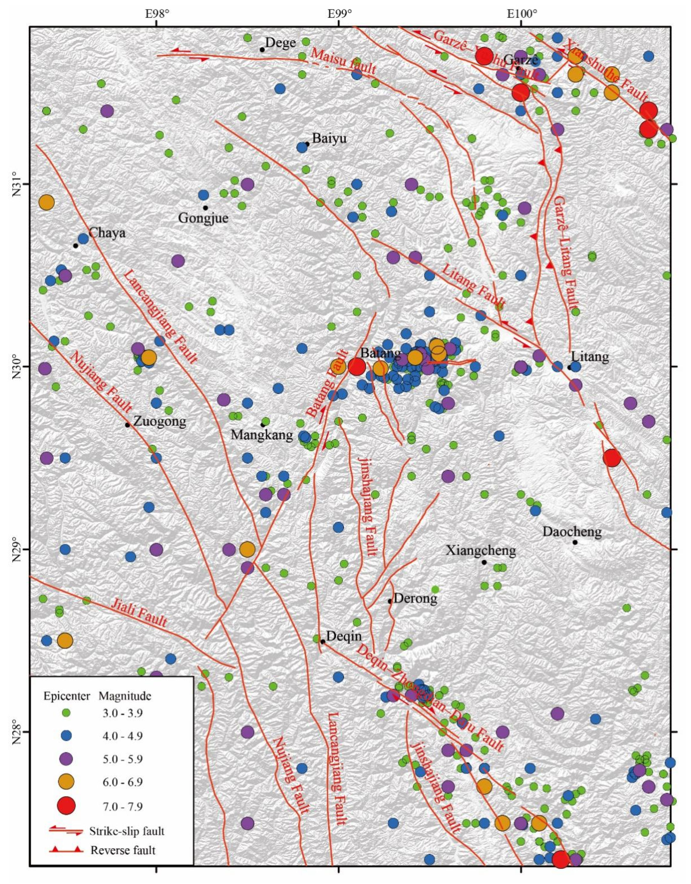
Figure 2.
(a) Distribution map of major faults and field survey sites in the middle section of the Jinshajiang fault zone and its adjacent areas. (b) On the basis of the GF-7 satellite data, a hillshade map was generated to interpret the detailed fault tracks of the Yarigong and Ciwu faults.
Figure 2.
(a) Distribution map of major faults and field survey sites in the middle section of the Jinshajiang fault zone and its adjacent areas. (b) On the basis of the GF-7 satellite data, a hillshade map was generated to interpret the detailed fault tracks of the Yarigong and Ciwu faults.
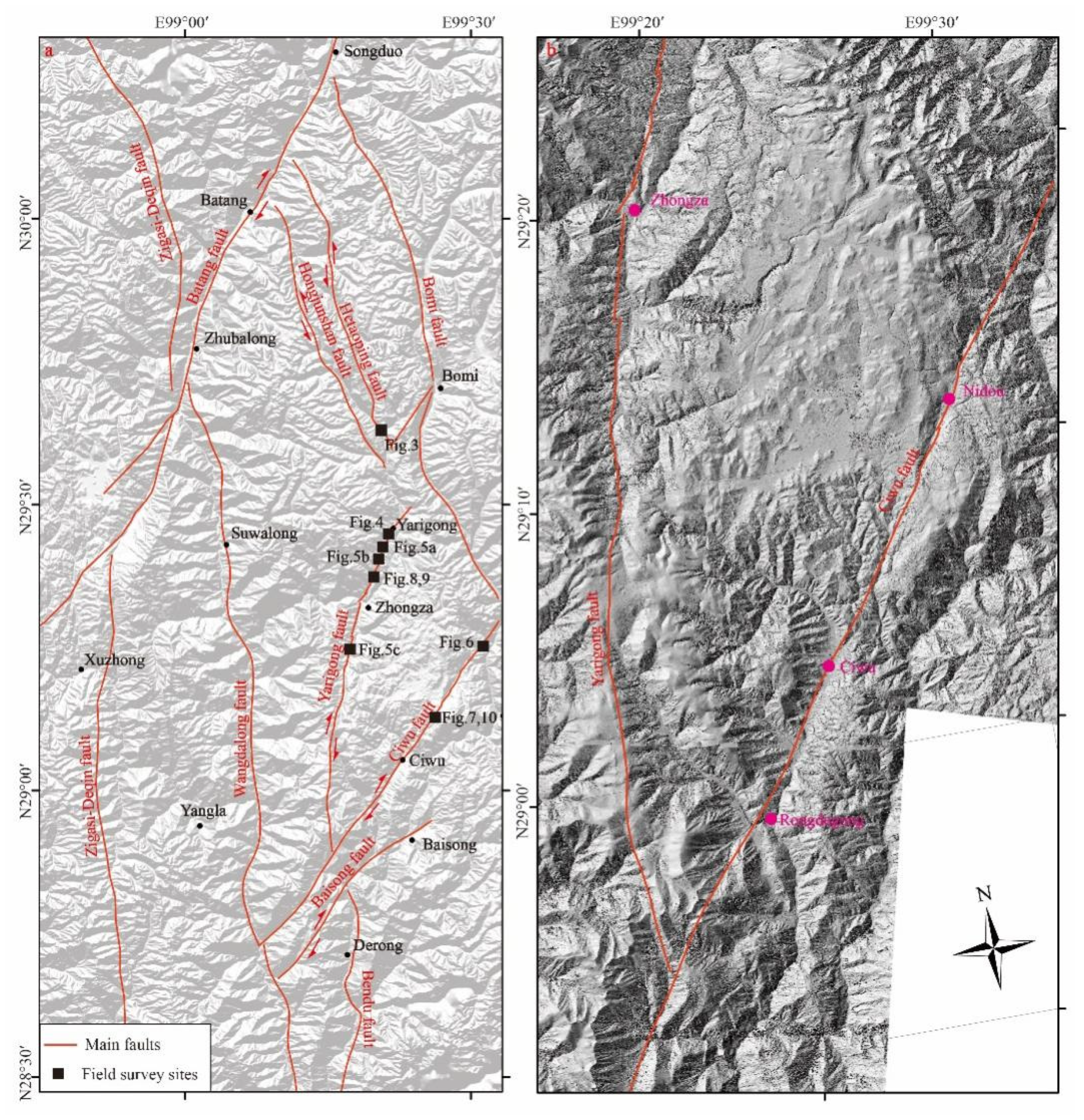
Figure 3.
(a) and (b) Geological profile of the Jinshajiang fault zone in Hongdong Village. (c) Photograph of the top of the geological section showing the fault displaced top strata.
Figure 3.
(a) and (b) Geological profile of the Jinshajiang fault zone in Hongdong Village. (c) Photograph of the top of the geological section showing the fault displaced top strata.
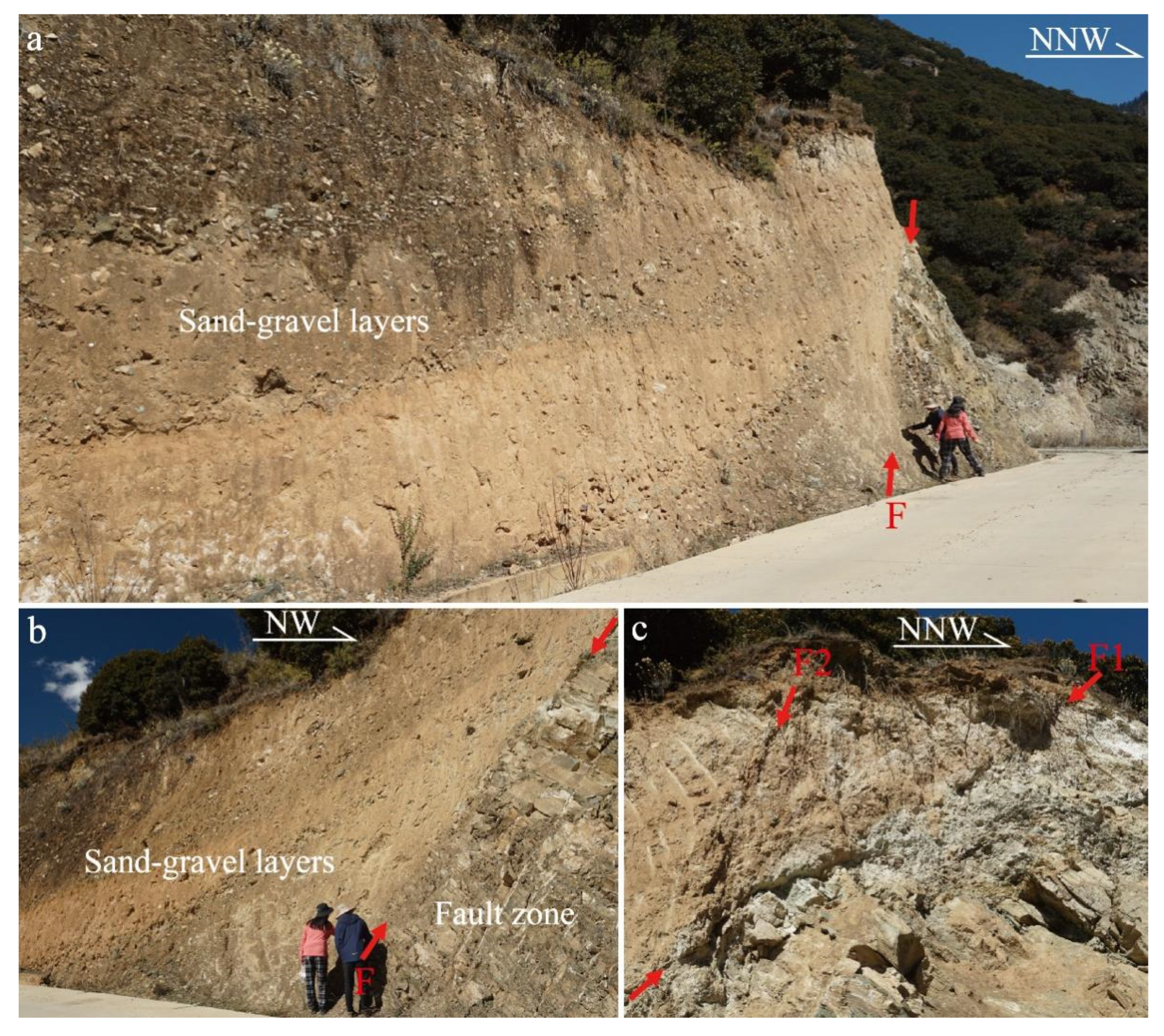
Figure 4.
Right-lateral offset of a gully and profiles of the dating sample collection south of Yarigong Town. (a) and (b) The right-lateral offset of the gully was obtained using unmanned aerial vehicle (UAV) photogrammetry. The white rectangle in panel (b) indicates the sampling location of the dating samples. (c) and (d) The dating samples were collected from the T4 and T3 terraces of the Muqu River, respectively.
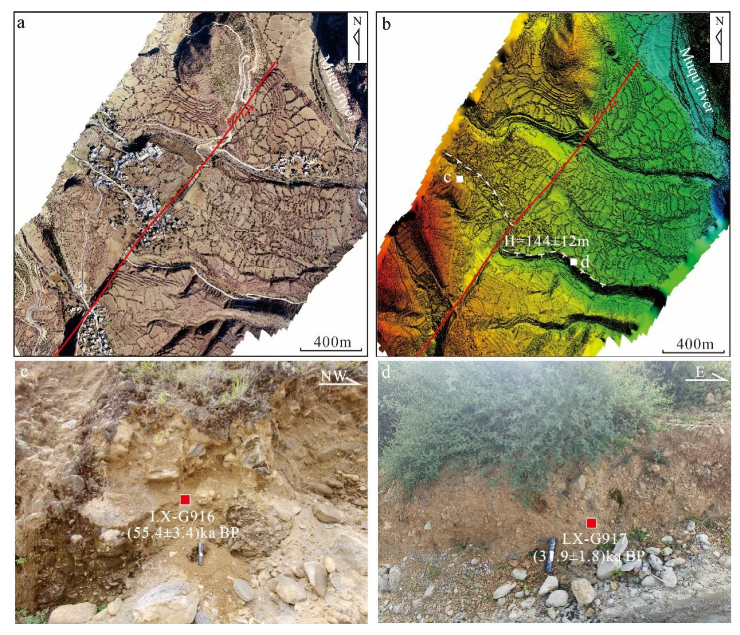
Figure 5.
Fault profiles exposed along the Yarigong fault. (a), (b) and (c) The fault profiles were exposed north of the Ran, Dalong and Lide villages, respectively, where the fault has displaced Late Quaternary strata.
Figure 5.
Fault profiles exposed along the Yarigong fault. (a), (b) and (c) The fault profiles were exposed north of the Ran, Dalong and Lide villages, respectively, where the fault has displaced Late Quaternary strata.
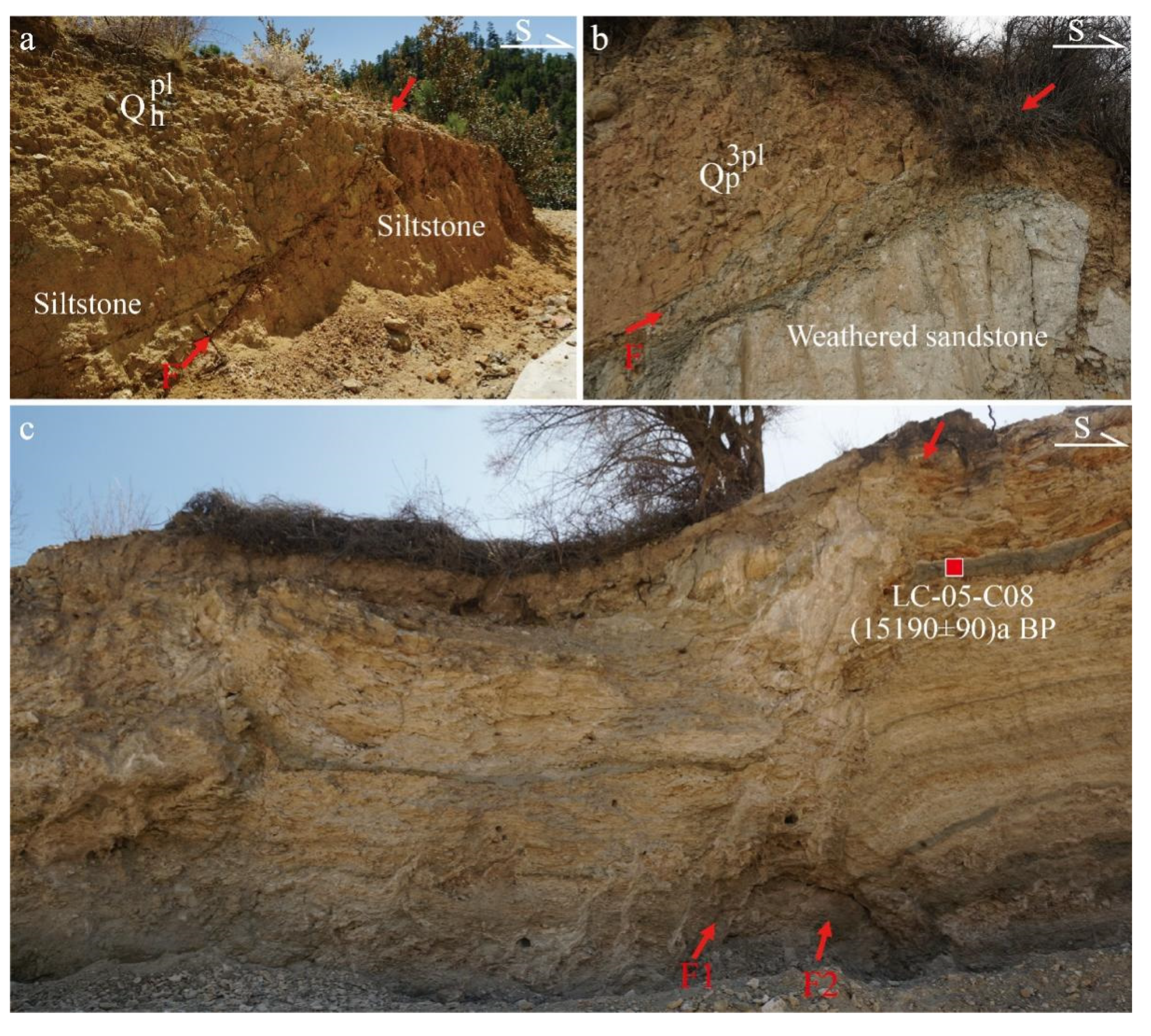
Figure 6.
Photograph of the fault profile and its explanatory profile.
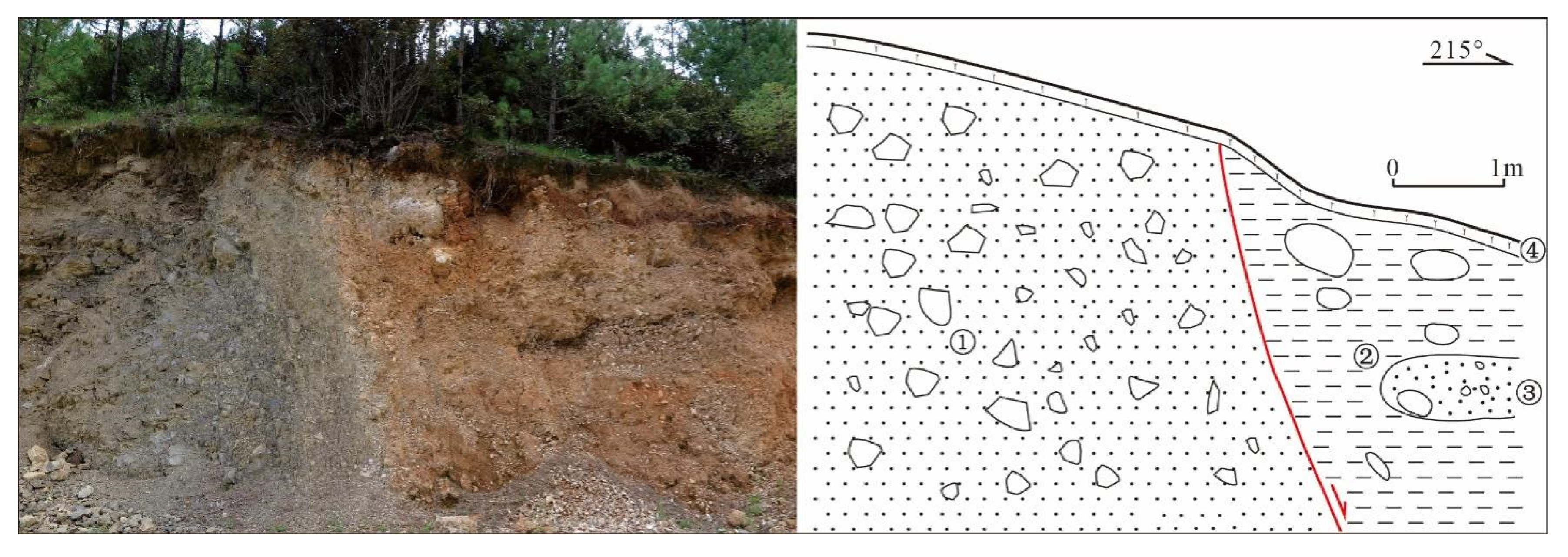
Figure 7.
Structural landform of the Ciwu fault southwest of Nidou Village. (a) Fault track of the newest activity of the Ciwu fault on the alluvial fan. (b) and (c) Linear fault trough gullies and reverse fault scarps.
Figure 7.
Structural landform of the Ciwu fault southwest of Nidou Village. (a) Fault track of the newest activity of the Ciwu fault on the alluvial fan. (b) and (c) Linear fault trough gullies and reverse fault scarps.
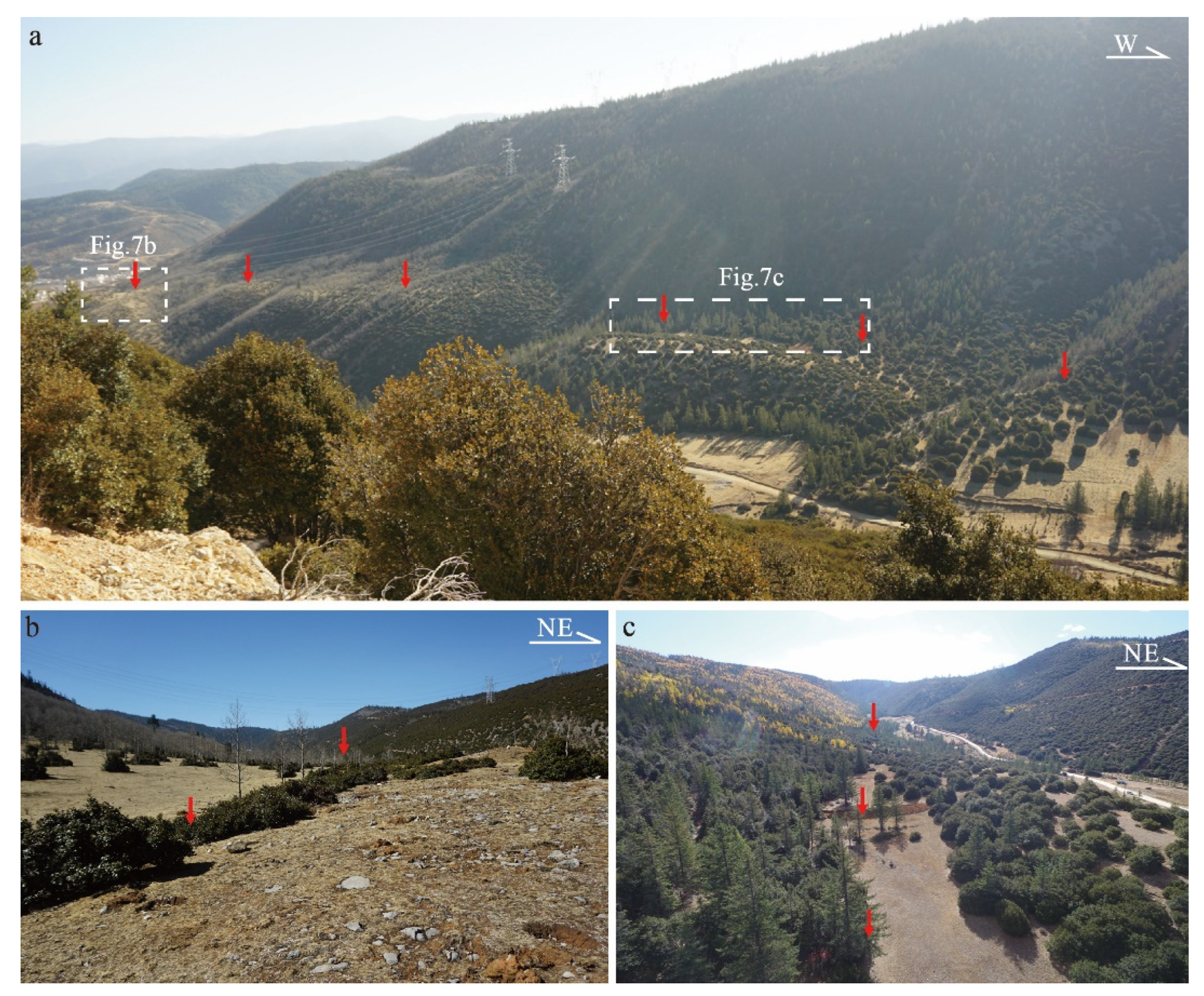
Figure 8.
(a) Right-lateral offset of the T2 terrace of the Ciwu River and location of the dating sample. The image was obtained using UAV photogrammetry. (b) Photograph showing the dating sample collection section in the T2 terrace of the Ciwu River.
Figure 8.
(a) Right-lateral offset of the T2 terrace of the Ciwu River and location of the dating sample. The image was obtained using UAV photogrammetry. (b) Photograph showing the dating sample collection section in the T2 terrace of the Ciwu River.
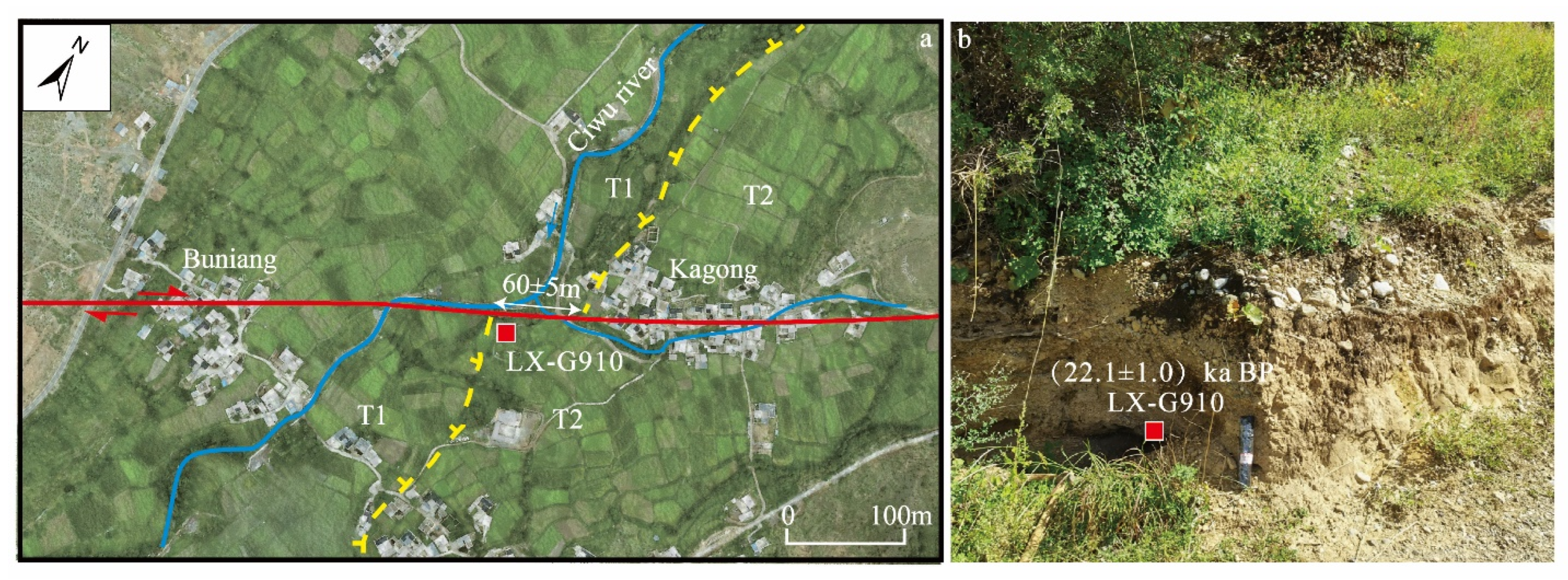
Figure 9.
(a) Tectonic landform near trench TC1 according to UAV photogrammetry. (b) Photograph of the linear fault trough the landform.
Figure 9.
(a) Tectonic landform near trench TC1 according to UAV photogrammetry. (b) Photograph of the linear fault trough the landform.
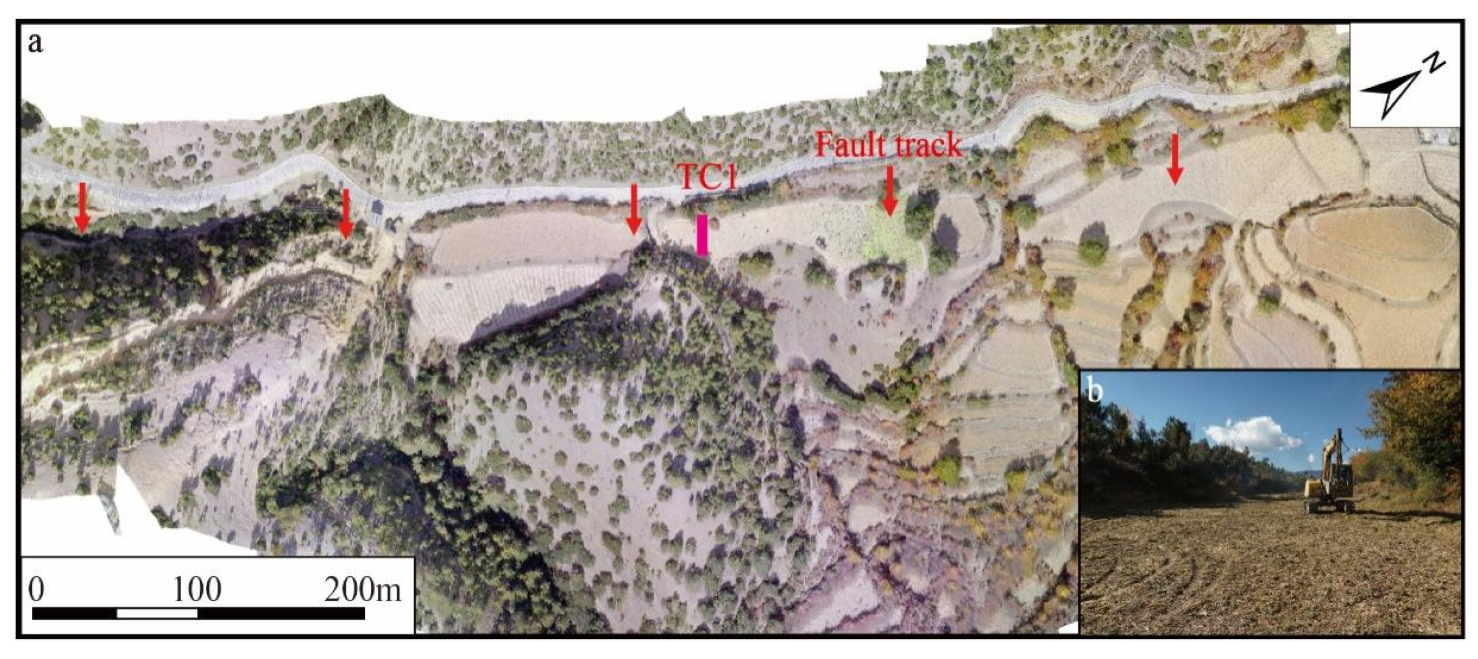
Figure 10.
Photograph of the southern wall of the Bugge trench and explanatory profile. The radiocarbon dating sample ages of the TC1 trench are detailed in Table 2.
Figure 10.
Photograph of the southern wall of the Bugge trench and explanatory profile. The radiocarbon dating sample ages of the TC1 trench are detailed in Table 2.
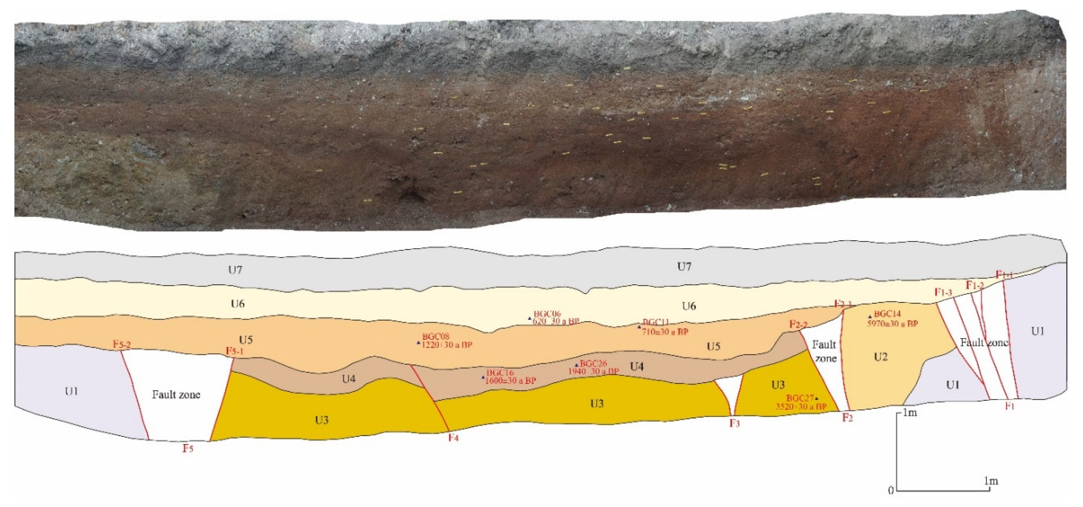
Figure 11.
(a) Tectonic landform near trench TC2 shown via UAV photogrammetry. The gully to the south of the site is right-laterally offset by approximately 18 ± 2 m. (b) Photograph of the trench site.
Figure 11.
(a) Tectonic landform near trench TC2 shown via UAV photogrammetry. The gully to the south of the site is right-laterally offset by approximately 18 ± 2 m. (b) Photograph of the trench site.
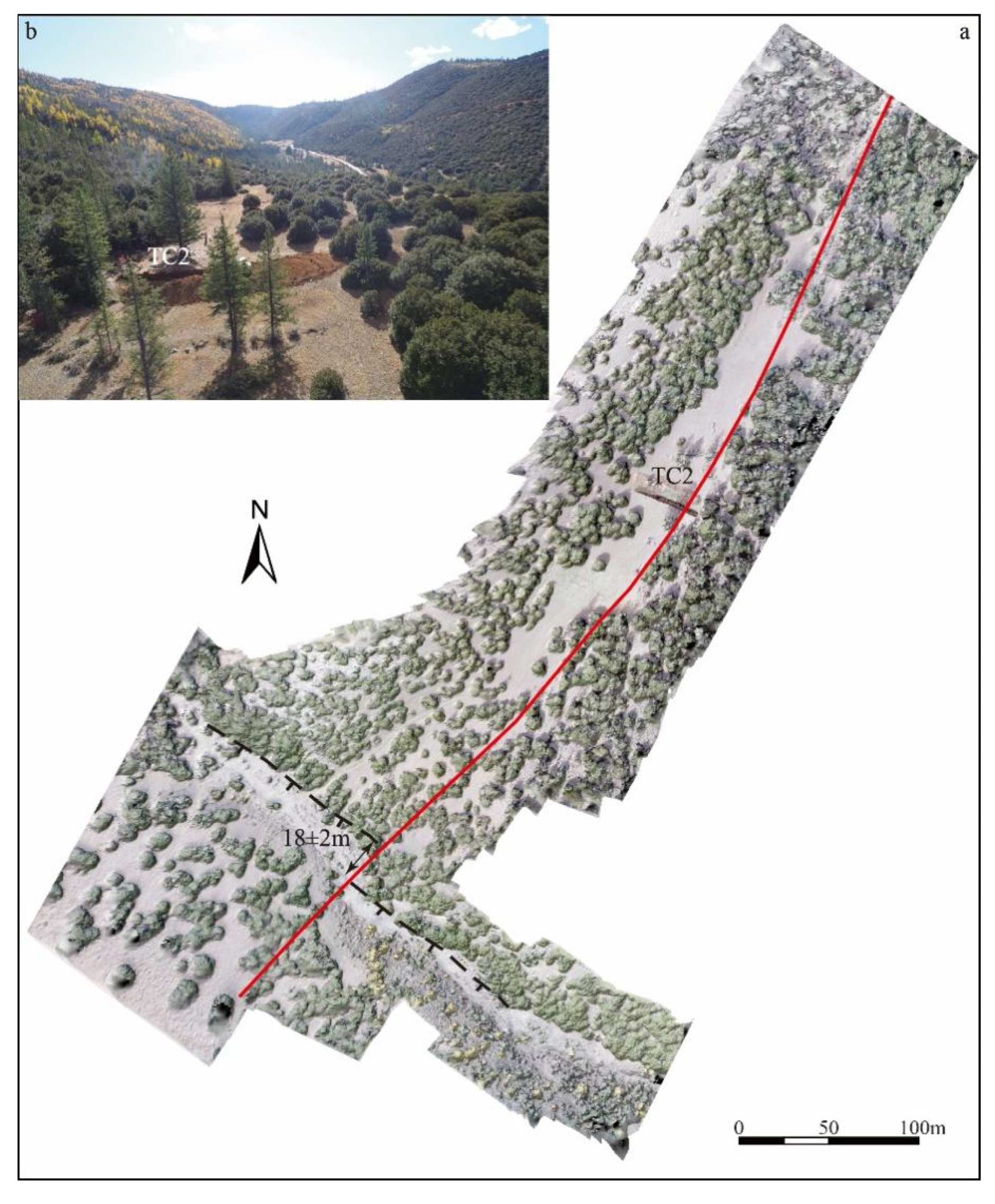
Figure 12.
Photograph of the southern wall of the Bugge trench and explanatory profile. The radiocarbon dating sample ages of the TC2 trench are detailed in Table 2.
Figure 12.
Photograph of the southern wall of the Bugge trench and explanatory profile. The radiocarbon dating sample ages of the TC2 trench are detailed in Table 2.
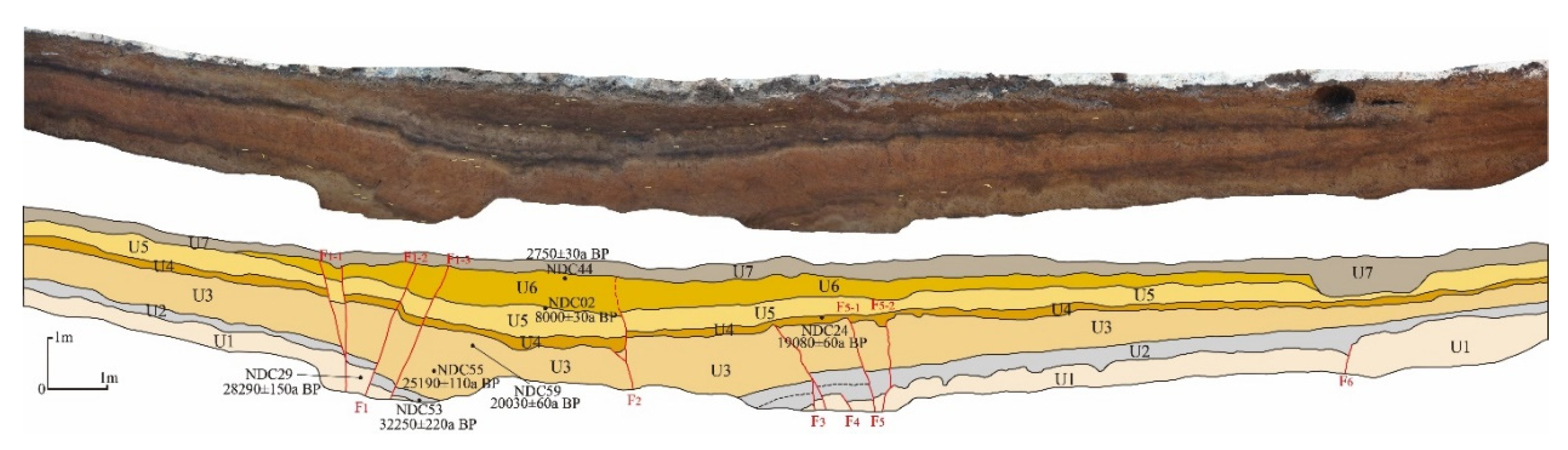
Figure 13.
Palaeoseismic sequences of the Yarigong and Ciwu faults, the raw carbon ages of which were calibrated using OxCal 4.4.4 [42].
Figure 13.
Palaeoseismic sequences of the Yarigong and Ciwu faults, the raw carbon ages of which were calibrated using OxCal 4.4.4 [42].
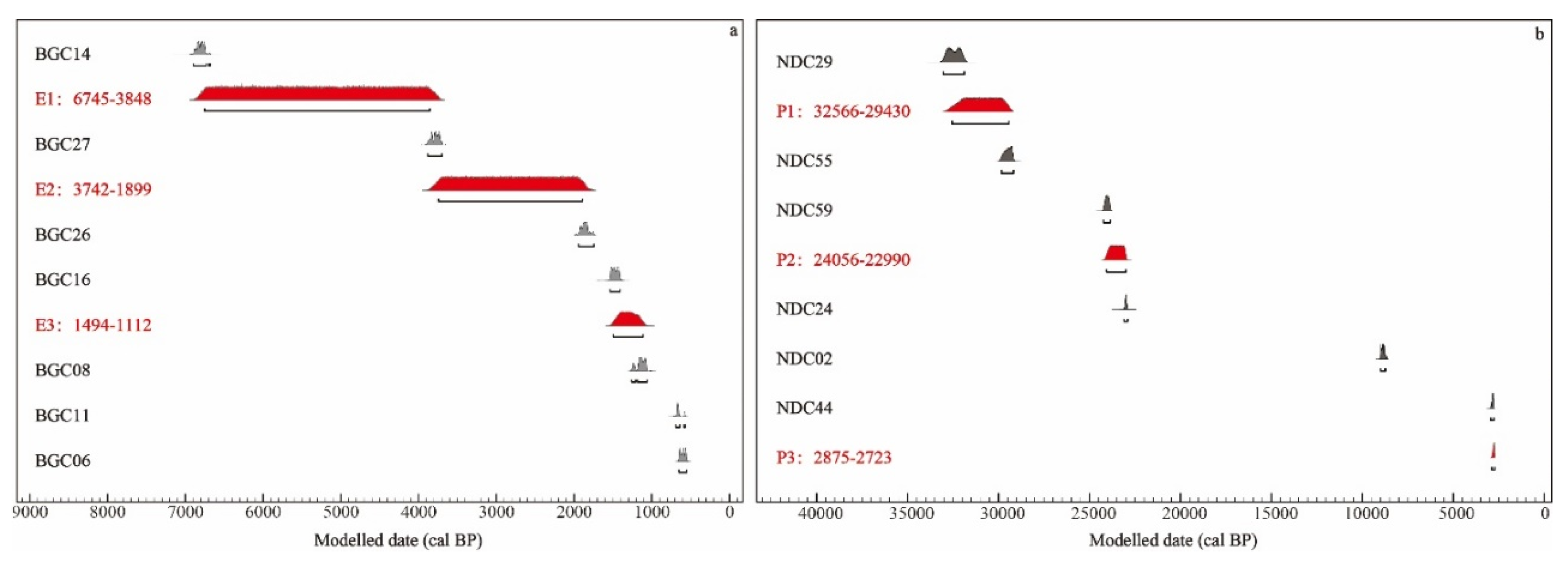

Table 1.
Optically stimulated luminescence (OSL) sample dating results.
| Sample | U(ppm) | Th(ppm) | K (%) | Annual dose rate (Gy/ka) |
Equivalent dose (Gy) |
Age(ka) |
| LX-G-910 | 2.72 | 13.22 | 1.00 | 2.5±0.1 | 55.3±2.6 | 22.1±1.0 |
| LX-G-916 | 3.44 | 13.8 | 1.85 | 3.5±0.1 | 194.0±11.7 | 55.4±3.4 |
| LX-G-917 | 3.6 | 15.1 | 1.44 | 3.2±0.1 | 102.1±5.9 | 31.9±1.8 |
Table 2.
Radiocarbon ages from samples collected in trenches TC1 and TC2.
| Sample | Lab.no | Description | 13C/12C (o/oo) |
Measured radiocarbon age (a BP) |
Conventional radiocarbon age (cal BP) |
| BGC06 | 647813 | charcoal | -24.1 | 620±30 | 654-550 |
| BGC08 | 660112 | charcoal | -23.6 | 1220±30 | 1180-1062 |
| BGC11 | 647812 | charcoal | -25.1 | 710±30 | 688-641 |
| BGC14 | 660113 | charcoal | -18.1 | 5970±30 | 6893-6731 |
| BGC16 | 660114 | charcoal | -19.6 | 1600±30 | 1534-1405 |
| BGC26 | 647811 | charcoal | -22.1 | 1940±30 | 1940-1746 |
| BGC27 | 647810 | charcoal | -24.1 | 3520±30 | 3880-3698 |
| NDC02 | 646655 | charcoal | -23.6 | 8000±30 | 9001-8754 |
| NDC24 | 660115 | charcoal | -23.2 | 19080±60 | 23109-22903 |
| NDC29 | 648911 | charcoal | -23.4 | 28290±150 | 33010-31860 |
| NDC44 | 660116 | charcoal | -25.2 | 2750±30 | 2889-2766 |
| NDC53 | 648912 | charcoal | -23.7 | 32250±220 | 37036-36158 |
| NDC55 | 660117 | charcoal | -22.5 | 25190±110 | 29844-29180 |
| NDC59 | 648913 | charcoal | -22.1 | 20030±60 | 24219-23857 |
Disclaimer/Publisher’s Note: The statements, opinions and data contained in all publications are solely those of the individual author(s) and contributor(s) and not of MDPI and/or the editor(s). MDPI and/or the editor(s) disclaim responsibility for any injury to people or property resulting from any ideas, methods, instructions or products referred to in the content. |
© 2024 by the authors. Licensee MDPI, Basel, Switzerland. This article is an open access article distributed under the terms and conditions of the Creative Commons Attribution (CC BY) license (http://creativecommons.org/licenses/by/4.0/).
Copyright: This open access article is published under a Creative Commons CC BY 4.0 license, which permit the free download, distribution, and reuse, provided that the author and preprint are cited in any reuse.


