
Submitted:
09 October 2024
Posted:
10 October 2024
You are already at the latest version
Abstract
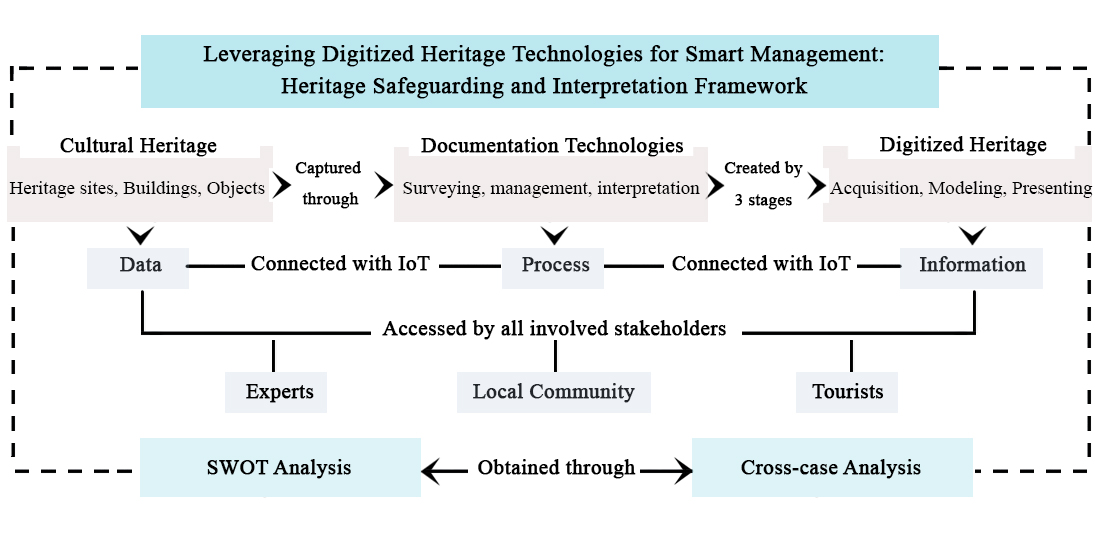
Digitized heritage is regarded as an emerging field, with existing studies primarily focusing on one case study or technological aspect. Thus, there remains a notable gap in the literature regarding the understanding of how these technologies can be utilized in smart heritage management. Approaches that harness technological advancements to enhance smart management and aid the decision-making process regarding the use of appropriate technology at various heritage sites remain insufficiently explored. To address this gap, this study conducted a cross-case analysis to survey the use of heritage technologies across selected cases to find underlying trends and correlations related to the scale and technology used. The findings of this study provide insights into the nexus of technology integration into heritage management, highlighting the role of tangible heritage documentation technologies. The present study concludes that smart management framework necessitates an ongoing process involving the integration of cultural heritage data, documentation, and the Internet of Things (IoT). IoT facilitates the connectivity of physical items to the internet, thereby supporting the safeguarding and interpretation of cultural heritage knowledge. Such framework operates through a collaboration platform that engages experts, local communities, and tourists to ensure a meaningful and interactive interconnection.
Keywords:
architectural heritage
; digital heritage
; heritage documentation
; smart heritage management
1. Introduction
Sustainable heritage protection is given prominence in international policies and conventions declared by the United Nations Educational, Scientific, and Cultural Organization (UNESCO) and its related organizations, including the International Council of Monuments and Sites (ICOMOS). In order to protect the natural and cultural heritage that possesses outstanding universal values (OUV) for future generations, the 1972 World Heritage Convention established the concept of World Heritage Sites [1]. Integrating the sustainable development goals into the execution of the World Heritage Convention necessitates developing a national, regional, and local conservation and management plan [2]. Thus, to guarantee cultural heritage preservation, every country has to create a management and conservation plan, offering strategic direction for sustainable protection [3,4]. In this regard, the Australian ICOMOS Burra Charter has developed an adaptable planning procedure that starts by gathering the data, followed by the evaluation and analysis phase to take the response by incorporating stakeholders at various levels of expertise [5]. Documentation is essential as a first step strikethrough and during the process, contributing to the site’s management and planning effectiveness. Nowadays, new digital tools for data collection and three-dimensional (3D) representation have become essential for the evolution of heritage site management and conservation plans [6]. Consequently, digitized heritage technologies could be used to record, reconstruct, manage, represent, and interpret cultural heritage knowledge in different domains [7,8]. Hence, digitalization might be the only method to recreate a destroyed object, particularly in the case of knowledge deficiencies regarding the construction process or if the original material needed for restoration is unavailable [9], by generating digital replicas in the form of 3D models in an optimized manner [10]. Accordingly, at the nexus of technology and heritage, digital heritage is the forefront topic [11]. It is a purposeful dialogue between culture, technology, and science [7].
In the context of this research, digital heritage is about harnessing the potential of digitized heritage technologies for enhancing the process of heritage management. Nonetheless, there is a growing interest in the application of digital technology to heritage management to promote the creation of smart heritage [12], to be operationalized at all levels of the management process [13]. Smart heritage is a theoretical perspective that views utilizing digitalization as a precondition for providing new capabilities for heritage identification, assessment, and response by involving the interaction between people and objects through smart devices in an information and communication technology environment (ICT) [11,14]. Digitized heritage and smart heritage are considered relatively new sciences [15,16]. In light of that, a growing number of studies have explored the role of using various technologies with respect to smart heritage conservation, management, representation, and interpretation [11,12,13,16,17,18,19,20]. Many technologies were proposed in the various studies to manage cultural heritage in different contexts. If the goal is to maximize resources in order to accomplish efficient preservation, a priority scale must be constructed [10]. Consequently, it is necessary to define the aims and scopes of the types of technological applications used and consider the capabilities of the applied techniques to prepare a suitable architectural documentation plan for cultural heritage management [6].
1.1. Research Problem, Justification, and Significance
The devastation of ancient palaces and temples in Nepal following the 2015 earthquake and the more recent and tragic fire at Notre Dame de Paris Cathedral in 2019 are just a few examples of the disastrous occurrences that heritage buildings have experienced [14]. Architectural heritage documentation has benefited from the diverse methods that emerged in the age of digitalization since traditional methods are expensive and labor-intensive [20]. However, many experts are not well-versed in the rapidly evolving technologies that can aid in recording cultural heritage [8]. As well, in some cases, the range of heritage technologies for achieving a particular result may not be understood [21].
Despite the high contribution of such studies, they typically concentrate on either specific technologies or categories of heritage. Thus, there is a need for comprehensive research in terms of making the decision regarding the most appropriate technology to be used where, for what, and how. Therefore, this study focuses on the process of digitally documenting architectural heritage that is regarded as valuable and worthy of being preserved and passed down to future generations. The goal is to explore the potential of heritage technologies in the smart management of cultural heritage. In summary, there is a lack of a comprehensive approach that can maximize the benefits of this technological revolution in order to aid the decision-making process concerning the exploration of various technological capabilities in heritage management at various sites. Accordingly, there is a need for more in-depth investigations in terms of studying the relationship between digitized heritage and smart management. To this end, this study sheds light on the interplay between digitized heritage and architectural heritage by explaining the potential of the various digital architectural heritage applications in smart management. The significance of this study lies in providing recommendations that can influence heritage management strategies on a worldwide scale and be utilized by local authorities, planners, and professionals. This study enables experts to make informed decisions about integrating heritage digitalization into smart management strategies.
1.2. Research Questions and Objectives
The primary research question, “What is the relationship between digitized heritage and smart heritage management?” was posed to explore the interplay between documentation technologies, digitized heritage, and smart management. Addressing such question necessities answering the following sub-questions: What are the primary classifications of digitized heritage technologies? And what is the underlying correlation between the heritage scale and the used technology? The overcharging goal of this research was to maximize the optimum benefits of digitized heritage technologies in the development of smart heritage safeguarding and interpretation farmwork. The objectives were to emphasize the significance of utilizing digitized heritage technologies in the documentation of architectural heritage, to survey the use of digital heritage technologies across selected cases to find underlying trends and correlations between scale and the technology used.
2. Materials and Methods
Desk research through a systematic literature review, which is one of the most employed procedures in the field of heritage reviews to structure pre-existing knowledge into themes and subthemes after summarizing previous studies' contributions and evaluating the consistency among them [22]. The same procedure was applied in this research to answer, “What are the primary classifications of digitized heritage technologies?”. Keyword searches in Science Direct, Scopus, Google Scholar, and MDPI journals for “Digital Heritage," "Heritage Documentation," "Surveying Technologies," "Image-based Technologies," "Range-based Technologies," "Virtual Heritage,” and "Management Technologies" support this review. Additional articles were chosen from the first selected papers to provide the needed explanation. Consequently, three themes emerged, as shown in Figure 1.
Cross-case analysis was applied to answer “What is the underlying correlation between the heritage scale and the used technology?”. Cross-cases is a collective or multi-site case study in which every case is thoroughly studied to identify potential patterns and uncover interconnecting themes that may connect these cases [23]. The goal was to analyze various heritage sites utilizing different heritage technologies to understand how they are used to manage architectural heritage. The cases were selected based on their location, heritage diversity, inscription on the World Heritage List, level of heritage digitalization, digitalization technology use, and purpose. Finally, a strengths, weaknesses, opportunities, and threats (SWOT) analysis was used to determine the capabilities of the various technologies employed in smart management. SWOT analysis is a popular method that could be applied to analyze interactive technologies, such as electric vehicles, Building Information Modeling (BIM), or the potential capabilities of heritage technologies [24]. In the context of this research, a SWOT analysis was used to clarify the various technological capabilities to record heritage, accuracy, resolution, detail, cost, needed expertise, and potential limitations or restrictions.
2.1. What Are the Primary Classifications of Digitized Heritage Technologies?
Documentation is the core of any management process, and generating a 3D model with adequate information is the foundation for heritage documentation to attain sustainable preservation. The digital documentation process usually involves a two-phase procedure: data acquisition and data interpretation, which are concerned with transferring data into useful information to build a well-structured database. For instance, all relevant object data is acquired using a range of data capture technologies. Followed by data interpretation to transform the obtained data into valuable information in terms of the objects' values. The provision of this base facilitates the management process in order to take the right response [25]. The use of digitized heritage technologies can lead to a variety of outcomes, including retrieving images of heritage sites, reconstruction, and even assistance in the management of a design intervention [26]. The best documentation methods must be selected according to precise, detailed, object-related inquiries. Choosing the proper technology necessitates having a certain degree of knowledge regarding the possible and available options, sustainability, and the associated limitations and deficiencies [27], as well as defining the documentation’s main aims and scopes [6]. To this end, Figure 2 represents a classification of the different digitized heritage applications based on their capabilities in heritage documentation into surveying, management, and interpretation.
2.1.1. Surveying Technologies
Digitizing tangible heritage starts with documentation through different surveying methods to create a digital archive of heritage data, including documents, maps, and pictures. The targeted object’s size, its accessibility and complexity, the availability of equipment, and its associated cost [28], in addition to documentation objectives, building condition, significance, and structural integrity, all influence the choice of the surveying technique [25]. The main objective of the surveying process is to record a building’s current situation and determine its measurements, geometry, style, and materials [12] by creating an accurate 3D model of a point network to enable an effective unification of the point clouds within a single coordinate system. The second objective is to connect this coordinated system to the height datum and national grid system to ensure its linkage to a larger geographic reference and establish a spatial relationship between the different scanned objects and their locations, which in turn opens the door for successive heritage analysis [28]. In light of this, geo-visualization and 3D-visualization technologies were classified as the main technologies used in digitized heritage technologies. Geo-visualization technologies are utilized in this regard to facilitate interactive visual analysis of spatial data [29]. Global Positioning Systems (GPS) and Geographic Information Systems (GIS) are the most popular georeferencing systems [13]. Choosing between these methods depends on the terrain’s nature, time availability, and targeted scale, as well as knowing their opportunities, benefits, and limitations.
Recently, the utilization of 3D visualization technologies for documentation has gained wide popularity since they can be used for the largest and smallest buildings and their surroundings [18]. The intended objective, the complexity of architecture, accessibility, and accuracy of work are important factors influencing the selection of 3D modeling method [6], in addition to quality, geometrical precision, color correctness, safety, and efficiency [27]. A professional scholar also selects the technology based on the physical state of each asset and the time frame needed to complete the documentation process [8], the size of the digitalization target, cost, texture acquisition, portability of equipment, skill requirements, productivity, accuracy, and adherence to standards [30]. However, the project’s requirements cannot be met by a single approach, and a variety of techniques must be used to get the intended outcome. Considering that, 3D visualization technologies were classified into range-based technologies such as total station theodolite and laser scanning; image-based technologies [6], such as photogrammetry and infrared thermography; and combining these categories introduces the emergence of hybrid technologies such as photo-laser scanners, structured light, and remote sensing technologies.
2.1.2. Management Technologies
The digitized heritage management process encompasses methods to organize, display, and disseminate stored digital information [9]. The objective of employing digitalization is to create a visual model that can be used for understanding, analyzing, and conveying cultural heritage significance. The goal here is to provide a proper interpretation of the valuable heritage data collected in all its forms. The most popular technique used for heritage modeling to gather, arrange, and integrate building data into a single framework is BIM. It is used as a tool and a system in heritage management. It is a process to control buildings in their lifecycle [15] and a way to generate 2D drawings [20]. It provides eight dimensions for the project data, starting with 2D drawings, 3D virtual replicas, 4D time data, 5D cost data, 6D sustainability-related data, 7D management data, and 8D safety data. Thus, project cost analysis, time schedules, facility management, sustainability analysis, and safety level analysis are among its capabilities [31]. Such capabilities accelerated its adoption in heritage digitalization and led to the creation of Historic Building Information Modeling (HBIM) [32]. Meanwhile, HBIM emerged to introduce BIM advantages to the heritage sector; it provides digital documentation for the targeted objects through parametric modeling approaches, along with creating spatial coordination and 3D visualization in an efficient manner [32]. In terms of data collection, it allows the use of different survey techniques in the creation of the point clouds. This phase, however, is considered difficult and time-consuming [15]. Moreover, creating an accurate and detailed 3D model entails large amounts of, which in turn increases the need for information technology requirements [31]. Other concerns could arise while implementing BIM in the documentation of existing buildings since its fundamental target is new buildings [15]. Also, its implementation requires a high level of expertise [33]. In short, HBIM is an efficient method for compiling documentation with the ability to be updated continuously, ensuring proper management, and bringing together all stakeholders and the interdisciplinary information pertaining to the object in an integrated environment.
2.1.3. Interpretation Technologies
Digitized heritage interpretation is considered as a process utilized to communicate or present cultural heritage knowledge to end-users [34]. With the emergence of new technological advancements, cultural heritage may now reach new audiences that had previously dismissed it or shown little interest. Digital technologies give improved explanations, introduce new ways of presenting knowledge, and facilitate more interaction over traditional techniques [33]. Interpretation technologies can produce digitally or physically any object with its real characteristics. 3D printing and 3D digital technologies in the context of cultural heritage have gained great momentum recently due to their contribution to heritage preservation [35]. Among these technologies, XR is at the forefront. It refers to the integrated physical and virtual realms via mobile devices. XR is comprised of three distinct types: virtual reality (VR), augmented reality (AR), and mixed reality (MR).
Such technologies are situated in the field of cultural heritage, for example, through their integration into a museum to introduce a dynamic level of experience and mitigate some problems associated with creating traditional exhibitions, such as limited spaces, foreign language constraints, the concept of borrowing rare artifacts, and cost [36]. Furthermore, it is employed to reconstruct buildings' exteriors and interiors [9]. Gamification, virtual museums, artifact reconstruction, intangible heritage, experience, heritage digitalization, tourism, and education are trending applications of AR technology in cultural heritage [37]. Hence, AR technologies are being used due to their personalization, motivation, and learning efficiency characteristics [38]. Several options, including rotate, pan, shift, resize, manipulate, or extract additional information, are provided by AR [36]. Thus, many options are provided beyond the visible layer on the screen, like in the case of an object's 3D model visualization [9]. VR technology is employed for cultural heritage documentation, reconstruction, and interpretation [36]. It is increasingly being used for cultural heritage knowledge transmission and representation; it raises awareness of historical, social, and aesthetic values [7]. The goal here is to create a digitally superior experience of cultural heritage through virtual tourism. Although there is a difference between the mentioned XR technologies, they all share an immersive experience that evokes imagined feelings. For example, onsite and online applications for heritage sites should be designed in alignment with ICOMOS Principles for heritage interpretation and presentation by conducting visitors research, adopting a collaborative design to involve various stakeholders, integrating wisely the needed technology to enhance but not to replace the original experience, providing a well-studied training programs for the staff, and ensuring the maximum levels of cultural heritage knowledge accessibility [39]. Thus, the priority here is achieving a balance between virtual and physical realities to maximize the opportunities for immersive experiences and engage users in meaningful and playful dialogues.
Furthermore, heritage revival has been covered by the different applications of 3D printing to save heritage from disappearing and make it available and accessible for everyone. 3D replicas and physical reconstructions of heritage objects are now possible, allowing users to physically interact with the valuable heritage objects [27]. 3D printing can create sophisticated physical models that could be used for education [27]. Thus, a high degree of flexibility is obtained by means of 3D printing in comparison with traditional methods [40]. Overall, 3D printing is becoming increasingly significant to help managing cultural assets across the world by enabling the duplication of delicate objects that cannot be touched behind glass displays.
2.2. What Is the Correlation between the Heritage Scale and the Used Technology?
Seven cases were selected to cover the diverse technologies used to record the different categories of OUV of tangible cultural heritage, since digitalization is being used to recreate small heritage objects, monuments, and their missing parts, along with entire buildings or even entire urban heritage. In this regard, Table 1 to 6 were created for each case to cover the documentation operation, the used technology, the technology characteristics, the case parts, and the objective of digitization.
2.2.1. The Temple of Abu Simbel – Egypt
The Temple of Abu Simbel is one of the remarkable creations of Egyptian architecture. This temple was entirely carved out of solid rock. It consists of the Great Temple of Ramses II and the smaller Temple of Nefertari; they were inscribed as a UNESCO World Heritage Site in 1979 [41]. Its cultural heritage significance, along with the human and natural threats imposed on it, led to the necessity of digital documentation, and creating a 3D digital model, as shown in Figure 3 and Table 1.
2.2.2. Petra – Jordan
The rock-cut Nabatean capital was inscribed on the World Heritage List in 1985. As a consequence of the UNESCO Siq Stability Project, the Zamani research team documented and protected Petra over the course of three years to provide a new perspective on understanding the site. Due to the light conditions, GPS signal deficiency in some areas, physical complexity, time constraints, data volume, and high cost, unmanned aerial vehicles, and close-range photogrammetry were not chosen to acquire data [43]. Therefore, site conditions influence the choice of the technology used, as shown in Figure 4 and Table 2.
2.2.3. The Colosseum - Italy
Although the Colosseum has suffered damage, primarily from earthquakes and stone thieves, it is still the largest remaining amphitheater in the world as a place used to host gladiatorial games. It was declared a World Heritage Site by UNESCO in 1980 [46]. The digital documentation of the Colosseum has been carried out by a specialized research team. They created a 3D point cloud using information gathered by laser scanners [47]. The Colosseum was part of a 3D Web-GIS documentation project to reconstruct the Valley of the Colosseum and the Palatine Hill [48,49], as shown in Figure 5. Table 3 illustrates the main technologies that were used to digitally reconstruct the Colosseum.
2.2.4. The Parthenon – Greece
One of the strongest visual representations of antiquity that have survived to the modern day is the Parthenon, which is situated atop the Athenian Acropolis. It is part of the acropolis, which is recognized by UNESCO as a World Heritage Site [51]. Due to its values and the current situation and location of its sculptures, several efforts have been made to digitally reconstruct the Parthenon to acquire a renewed experience [52,53]. Another contribution has been made by the Department of Information and Education of the Acropolis Restoration Service (YSMA), which is an interdisciplinary committee of experts responsible for the conservation works on the Athenian Acropolis. Table 4 illustrate the technologies used to digitally reconstruct the Parthenon and its parts.
2.2.5. The Great Wall - China
The Great Wall is an ancient Chinese fortification structure that primarily consisted of walls as well as many beacon towers, enemy towers, and military castles. In 1987, the Great Wall was inscribed in the UNESCO World Heritage Site list as an outstanding, exceptional testimony built by humans among different civilizations as symbolic significance in the history of China [55]. Due to its geographical environment and human-induced threats, the Great Wall has experienced several conditions that impact its structural integrity [56]. Thus, digital documentation in these circumstances is a must to save the outstanding values in a proper manner. The enemy tower is one of the most complicated remaining wall components. Its interior consists of four arches in all directions as well as two tunnels in the heart of the building, as shown in Figure 6.
2.2.6. The Notre-Dame de Paris Cathedral – Paris
It is part of the World Heritage Site; Paris, Banks of the Seine and an iconic French Gothic cathedral that has an artistic utilization of colored glass rosettes, vaults, buttresses, and ornamental sculptures. It was inscribed on the World Heritage List in 1991 for its outstanding universal values in art, architecture, and history. On April 15, 2019, a huge fire attached its outstanding structure and destroyed part of its roof and its iconic spire [58]. The catastrophe has proved the importance of digitalization. Thus, many efforts have been made to restore the destroyed parts. In this regard, digitalization is urgent since 3D digital models can provide an accurate and fast way to obtain exact measurements and techniques [10]. Table 6 illustrates the main technologies that were used to digitally reconstruct the cathedral and its parts.
According to the cross-case analysis, different technologies could be used to survey on the same scale to achieve the same purpose. Thus, further explanation is needed to aid experts and stakeholders in selecting the appropriate technology for heritage digitalization. In this response, SWOT survey, shown in Table 7, was needed to clarify the various technologies in terms of the ability to record heritage architectural and urban features, accuracy, resolution, level of details, cost, needed technical expertise, and potential limitations or restrictions. The use of a SWOT analysis in the context of this study is justified by its employment in prior studies for UAVs [24], laser scanning, and photogrammetry [64] use in the field of heritage digitalization, allowing for assessing their situation.
Through digitized heritage, a wide range of technologies are utilized for documenting cultural heritage. This involves achieving multi-documentation dimensions as the priority, including planning, conservation, education, and heritage tourism applications. As such, these goals could be obtained through smart heritage management. Considering this, the following section clarifies the role of digitized heritage technologies in the smart management of cultural heritage.
2.3. What Is the Relationship between Digitized Heritage and Smart Management?
Smart heritage occurs when smart technology and heritage overlap to deliver a unique and autonomous heritage experience by employing ICT to facilitate interactive information between people, media, and objects [85]. The significance of smart heritage lies in its capability to connect different stakeholders, including communities, institutions, and experts, to harness the needed efforts with the proper means that prioritize the inclusive preservation of cultural heritage [11]. Therefore, smart heritage is a relationship and a link between users of shared digital platforms, institutions, objects, visitors, and the actual and virtual worlds on both ends [86]. Therefore, digital heritage is considered a precondition for the creation of smart heritage. Thus, heritage smartness is achieved by the utilization of several cutting-edge technologies, allowing for the combination of both stakeholders and diverse services to collect and share cultural heritage information . Eventually, a smart cultural heritage environment entails the introduction of various technologies into heritage sites, museums, and monuments. Applying smart solutions encompasses the establishment of a user-friendly, open, and accessible platform and a heritage-related 3D visualization and real-time data platform. Combining BIM with other spatial data makes the process of building conservation and decision-making more rational [87]. BIM’s parametric dimension allows the creation of smart objects such as building materials and other attributes. Thus, BIM plays a crucial role in smart heritage decision-making, ensuring that heritage digitalization is the essence of smart heritage. In conclusion, smart heritage enables cultural heritage values and knowledge to be gained and transferred in an interactive manner. Smart heritage focuses on implementing more collaborative and interactive methods, making cultural data openly accessible, and subsequently expanding the possibilities for digital curation, interpretation, and innovation [29]. Here, ICT may support the emergence of new methods for smart heritage recording, interpretation, and presentation [12]. However, smart heritage may also be used as a management tool to address the issues of cultural heritage protection in three stages: pre-conservation, conservation, and post-conservation [85]. These possibilities are translated into their broader domain for the purpose of this study as management, including safeguarding and interpretation, in order to gain a more truthful interpretation and recognition of cultural heritage values.
Cultural heritage management with respect to safeguarding is achieved by the purposeful utilization of surveying and management technologies to sustainably protect cultural heritage. The data obtained from any heritage site falls under one of the four categories: heritage data, geometry, pathology, and performance data [88]. Heritage data is obtained to understand buildings historical background, typology, and function. Geometry data is captured to present the condition of the building’s precise shape, appearance, and attributes. Pathology data reflects the historic building alterations over time, considering the material quality and the structural system. Performance data is about collecting environmental data, including thermal comfort, indoor air quality, moisture survey, lighting/visual, acoustic, and energy performance [88]. Such processes involve interdisciplinary work from different sectors like heritage, museology, art, history, conservation, computer science, management, and communication [89]. Eventually, all the data are interpreted to achieve the first dimension of smart management: cultural heritage safeguarding, which relies on finding the right matrix between involved stakeholders, technological advancements, and the main objectives. The local community as well is another critical stakeholder, contributing to precious cultural heritage knowledge needed to enhance the management process [90]. Tourists, on the other hand, could see and interpret heritage values through a different lens by experiencing the heritage layers produced by the local community [90]. Adopting such a participatory concept empowers the role of the local community with respect to addressing local heritage issues and developing distinctive ways to showcase the heritage, promote its accessibility [89], and create collaborative digital heritage projects [19]. In the context of this research, experts from related disciplines, tourists, and the local community are the main stakeholders in any digital heritage intervention. Thus, a participatory design approach to smart heritage safeguarding is seen in the collaboration between interdisciplinary teams to develop creative, sustainable, and inclusive solutions by understanding end users' needs and expectations [19]. Despite its potential, participatory design in smart heritage safeguarding faces challenges, including conflicting expectations, knowledge gaps, and coordination issues [89].
On the other end of the spectrum, smart cultural heritage management (SCHM) demonstrations in the interpretation dimension are found in the explanations of heritage awareness, education, and tourism. For instance, cultural heritage awareness is about having trustworthy cultural heritage knowledge in the public sphere, which could encourage the public to take an active role in the management process through different technologies [91], such as XR applications, by activating the interactive role of users [9]. In cultural heritage education, technological advancement with respect to virtual recreations of heritage with their magnificent values open new avenues for experiential learning in all subject areas by allowing interactivity and facilitating the placement of the artifacts in their historical context [14,27] in order to provide an additional explanation in an enjoyable, creative, and attractive manner [38]. In addition, XR technology itself permits narrative telling and promotes tourism through an unprecedented and memorable user experience [7] by following a multiple dimensions and stages for integrating the smart technologies [92]. Furthermore, it extends the possibilities provided by conventional tourist experiences through online platforms, allowing disabled and elderly people to live in a virtual replica of a real tourist destination [93]. Digital heritage through a virtual tourism experience is capable of better-visualizing heritage values and establishing new ways of experiencing heritage [94]. In the context of this research, interdisciplinary experts, tourists, and the local community are the main stakeholders in any digital heritage intervention.
3. Results
Data acquisition and capturing of heritage sites, buildings, and objects could be obtained by diverse technologies. Thus, it is not an easy task; it requires a careful determination of the underlined goal of the survey process and well-structured knowledge about the several means and methods available today in the evolving field of architectural surveys. Once a three-dimensional digital database is produced, a row of digital material is created for heritage management, safeguarding, and interpretation. The sum of the mentioned surveying technologies falls under capturing and creating 3D replicas for tangible cultural heritage. Capturing architectural heritage is an introductory step to cultural heritage management, which involves safeguarding and interpreting cultural heritage by using the appropriate technologies. Following a thorough search of the body of published information, it is concluded that documentation in heritage digitalization across the different study cases encompasses three main stages, as shown in Figure 7.
The initial step is data acquisition from the diverse available sources for the targeted heritage objects using the various digital heritage documentation technologies. The next stage is about creating 3D digital models using different software. In this step, the 3D replicas could be constructed with BIM to add other related cultural heritage data in order to create a collaborative platform for combining all stakeholders with the value-extracted information, allowing for further management processes. Conducting these two steps ensures the continuous and sustainable management of cultural heritage objects. In the third stage, a further extension could be made by using the values obtained from the data and the virtual 3D models in other interpretation technologies like XR and 3D printing, leading to interpretation of cultural heritage knowledge in the various fields.
3.1. Correlation between Digitized Heritage Technology and Scale
In order to help heritage experts gain a better understanding of the latest technologies utilized in the digital heritage documentation process, shown in Table 7, select the appropriate technique based on the needs of the end user for data and the objective of the work since workflow flexibility is influenced by making the appropriate decisions.
As derived from the cross-case and SWOT analysis above, creating a well-designed digital heritage documentation plan necessitates determining the documentation operation and its intended objectives as well as selecting the appropriate technologies, considering several influential factors. Firstly, the scale of documentation, whether it is the object scale, which encompasses artifacts, statues, or specific building features; the on-site scale, which includes entire buildings or specific surfaces; or the off-site scale, such as entire landscapes, plays a vital role in determining the efficiency, accuracy, data quality, geometrical precision, and level of detail. Furthermore, the nature of tangible heritage objects encompasses the complexity of architectural heritage, its physical state, texture, and color correctness. Moreover, budgetary and time constraints are critical considerations in the trade-off between the various technological advancements. Technology’s safety, portability, skill requirements, software compatibility, adherence to standards, and environmental impact also influence the choice of documentation technologies. Subsequently, heritage digitalization involves the utilization of a wide range of technologies tailored to the specific scale and characteristics of the tangible heritage being documented. In essence, the underlying correlation between heritage category, scale, and the used technology is rooted in the necessity to align heritage technologies and operations with the specific attributes of different scales of heritage with the characteristics of the used technology. This correlation recognizes that varying scales of heritage possess distinct management plans.
3.2. Digitalized Heritage Technologies and Smart Management
Technological advancements offer significant opportunities to improve the management of heritage sites. Such integration is an essential step forward in heritage digitalization, thereby promoting smart heritage safeguarding and interpretation. The relationship between documentation technologies, heritage digitization, and smart management is interconnected and mutually reinforcing. Digital heritage documentation is often a precursor to digitized heritage; it provides the foundational data needed for digital preservation and analysis. Digital heritage documentation technologies provide the means to capture, record, manage, and present heritage assets in digital formats, while heritage digitalization facilitates the creation of heritage material replicas in digital repositories to be stored, managed, and disseminated. Smart heritage management then utilizes these digital heritage resources and connects them with IoT and ICT technologies to implement easily accessible, collaborative, and innovative strategies for cultural heritage safeguarding and interpretation. Accordingly, the relationship between heritage digitalization and smart heritage management is complementary and symbiotic. Eventually, smart heritage management leverages data analytics to derive insights from digitized heritage data, allowing experts to make evidence-based decisions at the theoretical and practical level of cultural heritage management. In the context of this study, Figure 8 demonstrates the proposed definition of smart management and its relationship with digitized heritage.
Accordingly, heritage digitalization is a precondition of smart heritage, and smart heritage safeguarding is a precondition of smart heritage management and interpretation. It could be concluded that smart heritage management covers two main dimensions: cultural heritage safeguarding and interpretation. Figure 9 demonstrates the relationship between heritage documentation technologies and smart management dimensions.
4. Discussion
Digital technologies enhance the protection of architectural heritage, allowing for the creation of interactive, public platforms for cultural heritage management. Such technologies support education, conservation, awareness-raising, social responsibility, and tourism growth. The goal is to maximize the accessibility of heritage management in a dynamic manner [16]. Thus, smart heritage management entails adopting both theoretical and practical improvements to protect cultural heritage and build an innovative public service system [29,85]. Accordingly, there is a need for efforts beyond digitization, focusing more on the social dimension by activating the collaborative role of stakeholders in cultural heritage management [95]. Communication networks like the IoT should be employed to link heritage digitalization technologies with urban components in order to achieve safeguarding goals. The focus here is to establish an effective and responsive management system [22].
Appropriately, each of these studies focused on one aspect of smart management without elucidating the safeguarding and interpretation dimensions and its relationship with the involved stakeholders and the used technologies. This study contributes to the field by presenting an inclusive understanding of smart heritage management framework, which is an ongoing process that entails the provision of cultural heritage data, documentation, and IoT as a specialized subset of ICT that deals with the connectivity of physical items to the internet, to safeguard and interpret cultural heritage knowledge through a collaboration platform to grasp the interest of involved experts, local communities, and tourists in order to ensure their proper interconnection, as shown in Figure 10.
Notably, the overarching aim of digitized heritage is to fulfill sustainable development goals encompassing environmental, economic, and social sustainability to create cultural heritage bonds [96]. Digital heritage application in heritage site management has transformative potential for driving economic sustainability [97]. This study underscores how the integration of technological innovation can stimulate a creative solution in the heritage management process, bolstering the economic vitality of local communities, enhancing the economic efficiency of tourists’ experiences, fostering the establishment of creative industries, and promoting new tourism maps. The findings of this study underscore the significance of the technology-led participation within heritage management, emphasizing its role in fostering deeper connections and social cohesion among involved stakeholders, aiming to encourage stronger social ties and interdisciplinary collaborations. The collaborative efforts between all involved stakeholders contribute to enhancing social sustainability [95]. Digitalization serves as a protective measure for heritage sites, creating virtual replicas to safeguard their values against climate change impacts [93].
Accordingly, several global efforts aim to bring heritage assets back to life through mapping worldwide heritage in 3D, and Jordan is no exception. Digitized heritage in Jordan is presented through the Endangered Archaeology in the Middle East and North Africa (EAMENA) platform. EAMENA specializes in providing valuable information about threatened heritage sites. Thus, it relies on using remote sensing technologies to monitor risk assessment [98]. Recently, mapping digital cultural heritage in Jordan (MaDiH) has contributed to the development of Jordan’s digital cultural heritage by identifying policies, standards, datasets, and key systems. It is a collaborative international project between the United Kingdom and Jordan resulting from mobilizing the efforts of King’s Digital Lab, the Council for British Research in the Levant, the Hashemite University, the Department of Antiquities, the EMMANA project, and the Jordanian Open-Source Association. Its outputs are represented by open-access and open-source databases forming the comprehensive knowledge archive network catalog and social media accounts for public communication [99]. The Zamani Project was also conceptualized in collaboration with UNESCO, the Getty Conservation Institute, and many other authorities to document heritage sites. Petra was spatially documented using various heritage digitalization techniques by the Zamani team [44]. Other remarkable digitalization efforts in Jordan are covered by the mediterranean growth area through innovation, modeling, and simulation (Med GAIMS) project, aiming to improve the tourism sector by adding gamification to the visitor experience. Med GAIMS intends to reimagine tourism as a journey in which exploration and education blend harmoniously, creating a memorable experience. Umm Qais and Ajloun Castle were selected to apply a gamification strategy for their sites [100].
This study delved exclusively into the role of digital technologies in the smart management of architectural heritage. While acknowledging the significance of intangible cultural heritage, such as oral traditions, performing arts, rituals, and social practices, this study narrows its scope to the smart management of digital architectural heritage. Thus, future studies could explore the connection between intangible heritage, digital documentation technologies, and smart management. Additionally, based on the findings of this study, future research could survey the current situation, and the level of digitized heritage applied in a local Jordanian case study like Umm Qais.
5. Conclusions
Digital heritage documentation through smart technology is the driving force behind smart heritage management. The concept is still in its infancy; thus, it is currently being explored by academia in order to identify and clarify its framework. For instance, cultural heritage protection might happen today with the use of current technical breakthroughs to achieve better heritage safeguarding, interpretation, and transmission. A variety of technologies might be used to collect data about cultural heritage sites, buildings, and objects. Therefore, it is not simple work; it calls for a rigorous selection of the survey process highlighted targets as well as organized knowledge of the many tools and procedures that are now accessible in the developing field of architectural management technologies.
Cultural heritage data is the essence of the whole management process. Such data, including heritage data, geometry, pathology, and performance data, are distributed among relevant stakeholders to fulfill one of the main goals of SCHM, heritage safeguarding, which depends on finding the appropriate matrices between the key objectives, the engaged stakeholders, and smart improvements. Successful SCHM should follow technology-led participation to establish each possible stakeholder’s identification and legitimacy. On the other hand, smart cultural heritage interpretation is explicit in the utilization of diverse interactive technologies to provide the public and tourists around the world with open and available access to cultural heritage knowledge. Raising cultural heritage awareness among the public guarantees their active participation in the SCHM process. By means of smart technologies, interactive, participatory platforms might be used to manage cultural heritage and harness the interests of all involved stakeholders, with a greater focus on public and tourist preferences. Thus, local, private, voluntary, and public efforts should all work together in this digitally integrated environment to ensure the success of SCHM by balancing technology-driven and participant-driven approaches. Consequently, the core of the SCHM process is the smart collaboration between all involved parties to better manage heritage values through ICT media and IoT networks.
Author Contributions
Conceptualization, R.H. and S.R.; methodology, R.H.; software, R.H.; validation, R.H., S.R. and S.A.; formal analysis, R.H.; investigation, R.H. and S.R.; resources, S.R and S.A..; data curation, R.H.; writing—original draft preparation, R.H.; writing—review and editing, S.R. and S.A.; visualization, R.H.; supervision, S.R. and S.A; project administration, S.R.; funding acquisition, R.H. All authors have read and agreed to the published version of the manuscript.
Funding
This research received no external funding.
Data Availability Statement
The original contributions presented in the study are included in the article, further inquiries can be directed to the corresponding author.
Acknowledgments
We would like to thank Prof. Rama Al Rabady, Dr. Yamen Al Betawi, and Dr. Rami Al shawabkeh for their expertise, constructive criticism, and time to examine Rahaf Hanaqtah’s thesis.
Conflicts of Interest
The authors declare no conflicts of interest.
References
- UNESCO. The Operational Guidelines for the Implementation of the World Heritage Convention; WHC: Paris, France, 2021. https://whc.unesco.org/en/guidelines/ (accessed on 26 September 2024).
- UNESCO. Policy Document for the Integration of a Sustainable Development Perspective into the Processes of the World Heritage Convention; WHC: Paris, France, 2015. https://whc.unesco.org/en/sustainabledevelopment/ (accessed on 26 September 2024).
- Castellanos, C. Sustainable Management for Archaeological Sites: The Case of Chan Chan, Peru. In Managing Change: Sustainable Approaches to the Conservation of the Built Environment; Teutonico, J., Matero, F., Eds.; The Getty Conservation Institute: Los Angeles, 2001; pp. 107-116.
- ICOMOS. The Seventh Edition Conservation Plan: A Guide To The Preparation Of Conservation Plans. Australia, 2013. https://australia.icomos.org/publications/the-conservation-plan/ (accessed on 26 September 2024).
- ICOMOS. The Burra Charter: The Australia ICOMOS Charter for Places of Cultural Significance. Australia, 1999. http://australia.icomos.org/wp-content/uploads/BURRA_CHARTER.pdf (accessed on 26 September 2024).
- Tobiasz, A.; Markiewicz, J.; Łapiński, S.; Nikel, J.; Kot, P.; Muradov, M. Review of Methods for Documentation, Management, and Sustainability of Cultural Heritage. Case Study: Museum of King Jan III’s Palace at Wilanów. Sustainability 2019, 11, 1-41. [CrossRef]
- Li, S. Exploring the Digital Age: The Carrying Capacity of Virtual Reality Technology for Historical and Cultural Heritage. Proceedings of the 2021 3rd International Conference on Economic Management and Cultural Industry (ICEMCI 2021), 2021.
- Hassani, F. Documentation of cultural heritage; techniques, potentials, and constraints. The International Archives of the Photogrammetry, Remote Sensing and Spatial Information Sciences 2015, XL-5/W7, 207–214.
- Mudička, .; Kapica, R. Digital Heritage, the Possibilities of Information Visualisation through Extended Reality Tools. Heritage 2022, 6, 112–131. [CrossRef]
- Leon, I.; Pérez, J.; Senderos, M. Advanced Techniques for Fast and Accurate Heritage Digitisation in Multiple Case Studies. Sustainability 2020, 12, 1-29. [CrossRef]
- Batchelor, D.; Schnabel, M. A.; Dudding, M. Smart Heritage: Defining the Discourse. Heritage 2021, 4, 1005-1015.
- Brusaporci, S.; Maiezza, P. Smart Architectural and Urban Heritage: An Applied Reflection. Heritage 2021, 4, 2044–2053.
- Trillo, C.; Aburamadan, R.; Makore, B.; Udeaja, C.; Moustaka, A.; Awuah, K.; Patel, D.; Mansuri, L. Towards Smart Planning Conservation of Heritage Cities: Digital Technologies and Heritage Conservation Planning. In Culture and Computing. Interactive Cultural Heritage and Arts, HCII 2021. Lecture Notes in Computer Science, M. Rauterberg eds.; Springer, Cham, Switzerland, 2021; pp. 133–151.
- Lopes, R.; Kumpoh, A.; Malik, O.; Ong, W.; Liu, Y.; Keasberry, C.; Chin, S. Exploring Digital Architectural Heritage in Brunei Darussalam: Towards Heritage Safeguarding, Smart Tourism, and Interactive Education. In IEEE Fifth International Conference on Multimedia Big Data (BigMM), Singapore, 11-13 September 2019.
- Pocobelli, D. P.; Boehm, J.; Bryan, P.; Still, J.; Grau-Bové, J. BIM for heritage science: a review. Heritage Science 2018, 6, 1-15. [CrossRef]
- Aburamadan, R.; Trillo, C.; Udeaja, C.; Moustaka, A.; Awuah, K.; Makore, B. Heritage conservation and digital technologies in Jordan. Digital Applications in Archaeology and Cultural Heritage 2021, 22.
- Albert, T.; Bernecker, R. 50 Years World Heritage Convention: Shared Responsibility – Conflict & Reconciliation; Springer Cham: Switzerland, 2022.
- Febro, J. D. 3D Documentation Of Cultural Heritage Sites Using Drone and Photogrammetry: A Case Study of Philippine Unesco-recognized Baroque Churches. International Transaction Journal of Engineering, Management, & Applied Sciences & Technologies 2022.
- Batchelor, D.; Schnabel, M. Smart Heritage as a Design Tool. Urbanie & Urbanus 2021, 20-29. [CrossRef]
- Themistocleous, K. The Use of UAVs for Cultural Heritage and Archaeology. In Remote Sensing for Archaeology and Cultural Landscapes, Best Practices and Perspectives Across Europe and the Middle East; Hadjimitsis, D.; Themistocleous, K.; Cuca, B.; Agapiou, A.; Lysandrou, V.; Lasaponara, R.; Lasaponara, R.; Masini, N.; Schreier, G.; Springer, Cham: Switzerland, 2019, pp. 241-269.
- Stylianidis, E. CIPA - Heritage Documentation 50 Years: Looking Backwards. The International Archives of the Photogrammetry Remote Sensing and Spatial Information Sciences 2019, XLII-2/W14.
- Song, H.; Selim, G. Smart Heritage for Urban Sustainability: A Review of Current Definitions and Future Developments. Journal of Contemporary Urban Affairs 2022, 6, 175–192. [CrossRef]
- Leavy, P. The Oxford Handbook of Qualitative Research. Oxford University: New York Press, 2014.
- Martín-Béjar, S.; Claver, J.; Sebastián, M.; Sevilla, L. Graphic Applications of Unmanned Aerial Vehicles (UAVs) in the Study of Industrial Heritage Assets. Applied Science 2020, 10, 8821. [CrossRef]
- Khalil, A.; Stravoravdis, S.; Backes, D. Categorisation of building data in the digital documentation of heritage buildings. Applied Geomatics 2020, 13, 29–54. [CrossRef]
- Stylianidis, E.; Evangelidi, K.; Vital, R.; Dafiotis, P.; Sylaiou, S. 3D Documentation and Visualization of Cultural Heritage Buildings through the Application of Geospatial Technologies. Heritage 2022, 5, 2818–2832. [CrossRef]
- Bentkowska-kafel, A.; Macdonald, L. Digital Techniques for Documenting and Preserving Cultural Heritage. Arc Humanities Press: Kalamazoo and Bradford, 2017.
- Boardman, C.; Bryan, P.; Bedford, J. 3D Laser Scanning for Heritage: Advice and Guidance on the Use of Laser Scanning in Archaeology and Architecture; Historic England, England, UK, 2018.
- Borda, A., & Bowen, J. P. Smart Cities and Cultural Heritage – A Review of Developments and Future Opportunities. In Proceedings EVA London 2017: Electronic Visualisation and the Arts, London, UK, 11 – 13 July 2017.
- Pavlidis, G.; Koutsoudis, A.; Arnaoutoglou, F.; Tsioukas, V.; Chamzas, C. Methods for 3D digitization of Cultural Heritage. Journal of Cultural Heritage 2007, 8, 93-98. [CrossRef]
- Elashry, A. Digital Documentation and Conservation of Urban Heritage. Master Thesis, Alexandria University, Egypt, 2019.
- Antonopoulou, S.; Bryan, P. BIM for Heritage: Developing a Historic Building Information Model; Historic England, England, UK, 2017.
- Straus, M.; Starc-Peceny, U.; Ceglar, K.; Ilijaš, T. Digital Innovation of Cultural Heritage: Handbook for tourist destinations and cultural heritage institutions; Arctur d.o.o., Industrijska cesta 1a, 5000 Nova Gorica: Nova Gorica, 2022.
- Rahaman, H. Digital heritage interpretation: a conceptual framework. Digital Creativity 2018, 29, 208-234. [CrossRef]
- 35. Tissen, L.; Malik, U. S.; Vermeeren, A. 3D Reproductions of Cultural Heritage Artefacts: Evaluation of significance and experience. Studies in Digital Heritage 2021, 5, 1-29.
- Bruno, F.; Bruno, S.; Sensi, G.; Luchi, L.; Mancuso, S.; Muzzupappa, M. From 3D reconstruction to virtual reality: A complete methodology for digital archaeological exhibition. Journal of Cultural Heritage 2010, 11, 42-49. [CrossRef]
- Boboc, R. G.; Băutu, E.; Gîrbacia, F.; Popovici, N.; Popovici, D.-M. Augmented Reality in Cultural Heritage: An Overview of the Last Decade of Applications. Applied Science 2022, 12, 9859. [CrossRef]
- Paliokas, I.; Patenidis, A.T.; Mitsopoulou, E.E.; Tsita, C.; Pehlivanides, G.; Karyati, E.; Tsafaras, S.; Stathopoulos, E.A.; Kokkalas, A.; Diplaris, S.; et al. A Gamified Augmented Reality Application for Digital Heritage and Tourism. Applied Science. 2020, 10, 7868. [CrossRef]
- Sartori, A.; Lazzeretti, L. The role of digital technologies in heritage interpretation: a conceptual framework and some recommendations. In 8th ICOMOS General Assembly and Scientific Symposium “Heritage and Landscape as Human Values”, Florence, Italy, 10–14 November 2014.
- Montusiewicz, J.; Barszcz, M.; Korga, S. Preparation of 3D Models of Cultural Heritage Objects to Be Recognised by Touch by the Blind—Case Studies. Applied Science. 2022, 12, 11910. [CrossRef]
- Elbshbeshi, A.; Gomaa, A.; Mohamed, A.; Othman, A.; Ibraheem, I.M.; Ghazala, H. Applying Geomatics Techniques for Documenting Heritage Buildings in Aswan Region, Egypt: A Case Study of the Temple of Abu Simbel. Heritage 2023, 6, 742-761. [CrossRef]
- Mozaik Education. Available online: https://www.mozaweb.com/hu/Extra-3D_modell-Abu_Szimbel_i_templomok-528557 (accessed on June 30, 2023).
- Ruther, H.; Bhurtha, R.; Schroeder, R.; Wessels, S. Spatial Documentation of the Petra World Heritage Site. In Proceedings of Africa Geo Conference, Cape Town, South Africa, 2014.
- Zamani Project. Available online: https://www.zamaniproject.org/index.html#header2-r5 (accessed on June 30, 2023).
- Wessels, S.; Ruther, H.; Bhurtha, R.; Schroeder, R. Design and creation of a 3D virtual tour of the world heritage site of Petra, Jordan. In Proceedings of Africa Geo Conference, Cape Town, South Africa, 2015.
- UNESCO. Available online: https://whc.unesco.org/en/list/91/ (accessed on 30, June, 2023).
- Uneversity of Arkansas. Available online: https://arkansasresearch.uark.edu/rebuilding-ancient-structures-with-time-scanners/ (accessed on 30, June, 2023).
- d’Annibale, E.; Tassetti, A. N.; Malinverni, E. S. Finalizing a Low-Cost Photogrammetric Workflow: From Panoramic Photos to Heritage 3D Documentation and Visualization. International Journal of Heritage in the Digital Era 2014, 3, 33-49. [CrossRef]
- Panella , C.; Fano, M.; Brienza, E.; Carlani, R. A 3D Web-GIS for the Valley of the Colosseum and the Palatine Hill. In Proceedings of the 35th International Conference on Computer Applications and Quantitative Methods in Archaeology (CAA), Berlin, Germany, 2–6, April, 2007.
- Sundell, L. Reconstructing buildings with 3D graphics and VR technology. Master thesis, Luleå University of Technology, Sweden, 2022.
- Remondino, F.; El-Hakim, S.; Baltsavias, E.; Picard, M. Image-based 3D modeling of the Erechteion, Acropolis of Athens. The International Archives of the Photogrammetry, Remote Sensing and Spatial Information Sciences 2008, XXXVII, 1101- 1106.
- Stumpfel, J.; Tchou, C.; Yun, N.; Martinez, P. Digital Reunification of the Parthenon and its Sculptures. In Proceedings of the VAST 2003: The 4th International Symposium on Virtual Reality, Archaeology and Intelligent Cultural Heritage, Brighton, United Kingdom, 2003.
- Bouzakis, K.-D.; Pantermalis, D.; Mirisidis , I.; Grigoriadou, M.; Varitis , E.; Sakellaridou, A.; Diamanti, E. 3D-laser scanning of the Parthenon west frieze blocks and their digital assembly based on extracted characteristic geometrical details. Journal of Archaeological Science: Reports 2016, 6, 94–108. [CrossRef]
- YSMA. Available online: https://www.ysma.gr/en (accessed on 1, July, 2023).
- UNESCO. Available online: https://whc.unesco.org/en/list/438/ (accessed on 28, August, 2023).
- Hua, W.; Qiao, Y.; Hou, M. The Great Wall 3D Documentation and Application Based on Multi-source Data Fusion: A case study of no.15 enemy tower of the new guangwu great wall. The International Archives of the Photogrammetry, Remote Sensing and Spatial Information Sciences 2020, XLIII-B2-2020, 1465 - 1470.
- Tencent Available online: https://www.tencent.com/en-us/articles/2201254.html (accessed on 20 July 2023).
- UNESCO Available online: https://whc.unesco.org/en/news/2102 (accessed on 14 July 2023).
- Tenschert, R. Cathedral Norte Dame in Paris – the Inscription of the South Transepts Façade: Medieval Relict or 19th Century Recreation? The International Archives of the Photogrammetry Remote Sensing and Spatial Information Sciences 2019, XLII-2/W15, 1141-1147.
- Gros, A.; Guillem, A. Faceting the post-disaster-built heritage reconstruction process within the digital twin framework for Notre-Dame de Paris. Nature 2023, 13, 5981. [CrossRef]
- Autodesk. Available online: https://www.autodesk.com/autodesk-university/article/Digitizing-History-Preserving-and-Recreating-Heritage-Sites-Digital-Tools-2020 (accessed on 28, August, 2023).
- Autodesk. Available online: https://www.autodesk.com/design-make/articles/notre-dame-de-paris-landscape-design (accessed on 13, September, 2023).
- Medium. Available online: https://medium.com/@eric_geboers/rebuiling-notre-dame-a-phoenix-rising-from-the-ashes-f087bf89f5ed (accessed on 2, July, 2023).
- Hassan, A. T.; Fritsch, D. Integration of Laser Scanning and Photogrammetry in 3D/4D Cultural Heritage Preservation – A Review. International Journal of Applied Science and Technology 2019, 9, 76-91.
- Goeldner, R. TachyGIS – An Idea to Survey Archaeological Excavations with Total Station and GIS. In Proceedings of the 24th International Conference on Cultural Heritage and New Technologies. Vienna, Austria, 2019.
- Arif, R.; Essa, K. Evolving Techniques of Documentation of a World Heritage Site in Lahore. The International Archives of the Photogrammetry, Remote Sensing and Spatial Information Sciences 2017, XLII-2/W5, 33-40.
- Kantaros, A.; Ganetsos, T.; Petrescu, F. I. Three-Dimensional Printing and 3D Scanning: Emerging Exhibiting High Potential in the Field of Cultural Heritage. Applied Science 2023, 13, 4777. [CrossRef]
- Zhu, X.; Elgin, D. Laser safety in design of near-infrared scanning LIDARs. In Proceedings of the SPIE, 19 May 2015.
- Kęsik, J.; Żyła, K.; Montusiewicz, J.; Miłosz, M.; Neamtu, C.; Juszczyk, M. A Methodical Approach to 3D Scanning of Heritage Objects Being under Continuous Display. Applied Science. 2023, 13, 441. [CrossRef]
- Bassier, M.; Deloof, T.; Vincke, S.; Vergauwen, M. Panoramic Image Application for Cultural Heritage. In Digital Heritage. Progress in Cultural Heritage: Documentation, Preservation, and Protection. Ioannides, M.; Fink, E.; Brumana, R.; Patias, P.; Doulamis, A.; Martins, J.; Wallace M.; Springer, Cham, 2018; vol 11196, pp. 386–395.
- Fangi, G. Further developments of the spherical photogrammetry for cultural heritage. In Proceedings of 22nd CIPA Symposium, Kyoto, Japan, 11-15, October, 2009.
- Jinsong, F.; Yanbing, F.; Jigang, P. HDR Spherical Panoramic Image Technology and its Applications in Ancient Building Heritage Protection. In Proceedings of the 2009 IEEE 10th International Conference on Computer-Aided Industrial Design & Conceptual Design, Wenzhou, 26-29 November 2009.
- Alshawabkeh, Y.; Baik, A.; Miky, Y. Integration of Laser Scanner and Photogrammetry for Heritage BIM Enhancement. ISPRS International Journal of Geo-Information 2021, 10, 316. [CrossRef]
- Moyano, J.; Nieto-Julián, J.E.; Bienvenido-Huertas, D.; Marín-García, D. Validation of Close-Range Photogrammetry for Architectural and Archaeological Heritage: Analysis of Point Density and 3D Mesh Geometry. Remote Sensing 2020, 12, 3571.
- Bayyati, A. Modern Surveying Technology: availability and suitability for Heritage Building Surveying and Heritage Building Information Models (HerBIM). In Proceedings of the 4th International Conference on Heritage and Sustainable Development, . Guimaraes, Portugal, 22 - 25 Jul 2017.
- Rachmawati, T.S.N.; Kim, S. Unmanned Aerial Vehicles (UAV) Integration with Digital Technologies toward Construction 4.0: A Systematic Literature Review. Sustainability 2022, 14, 5708.
- Mantey, S.; Tagoe, N. Digital Preservation of Cultural Heritage Sites using Unmanned Aerial Vehicle - A Case Study. Ghana Journal of Technology 2019, 4, 23-30.
- Núñez-Camarena, G.M.; Herrera-Limones, R.; López-Escamilla, Á. Use of Unmanned Aerial Vehicle Technology in the Protection of Goods of Cultural Interest (GCIs): The Case of the Castle of Cala (Huelva, Spain). Architecture 2024, 4, 247-266. [CrossRef]
- Sutherland, N.; Marsh, S.; Priestnall, G.; Bryan, P.; Mills, J. InfraRed Thermography and 3D-Data Fusion for Architectural Heritage: A Scoping Review. Remote Sensing 2023, 15, 2422. [CrossRef]
- Adamopoulos, E.; Volinia, M.; Girotto, M.; Rinaudo, F. Three-Dimensional Thermal Mapping from IRT Images for Rapid Architectural Heritage NDT. Buildings 2020, 10, 187. [CrossRef]
- Dlesk, A.; Vach, K.; Pavelka, K. Photogrammetric Co-Processing of Thermal Infrared Images and RGB Images. Sensors 2022, 22, 1655. [CrossRef]
- Masciotta, M. G.; Sánchez-Aparicio, L. J.; Oliveira, D.; Gonzalez-Aguilera, D. Integration of Laser Scanning Technologies and 360º Photography for the Digital Documentation and Management of Cultural Heritage Buildings. International Journal of Architectural Heritage 2022, 17, 56-75. [CrossRef]
- 83. Luo, L.; Wang , X.; Guo, H.; Lasaponara, R.; Zong , X.; Masini, N.; Wang, G.; Shi, P.; Khatteli, H.; Chen, F.; Tariq, S.; Shao, j.; Bachagha , N.; Yang. R.; Yao , Y. Airborne and spaceborne remote sensing for archaeological and cultural heritage applications: A review of the century (1907–2017). Remote Sensing for Environment 2019, 232, 111280. [CrossRef]
- Chen , F.; Guo, H.; Tapete, D.; Cigna , F.; Piro, S.; Lasaponara, R.; Masini, N. The role of imaging radar in cultural heritage: From technologies to applications. International Journal of Applied Earth Observation and Geoinformation 2022, 112, 102907. [CrossRef]
- Adrian, S.; Kurniawan, K. Smart Heritage: Media for Realizing Cultural Heritage Conservation in the Smart City Era. In Proceedings of the Proceedings of the IOP Conference Series: Earth and Environmental Science, 2020.
- Wang, Y.; Dai, X.; Jung, J.; Choi, C. Performance analysis of smart cultural heritage protection oriented wireless networks. Future Generation Computer Systems 2018, 81, 593-600. [CrossRef]
- Khoshelham, K. Smart Heritage: Challenges in Digitisation and Spatial Information Modelling of Historical Buildings. In Proceedings of the Computing Techniques For Spatio-Temporal Data in Archaeology And Cultural Heritage, Melbourne, Australia, 2018.
- Khalil, A.; Stravoravdis, S.; Backes, D. Categorisation of building data in the digital documentation of heritage buildings. Applied Geomatics 2020, 13, 29–54. [CrossRef]
- Nofal, E. Participatory Design Workshops: Interdisciplinary Encounters within a Collaborative Digital Heritage Project. Heritage 2023, 6, 2752-2766. [CrossRef]
- Calvi, L.; Weber-Sabil, J.; Asmar, D.; Socías Perez, X. A Framework for Stakeholders’ Involvement in Digital Productions for Cultural Heritage Tourism. Multimodal Technologies and Interaction. 2022, 6, 52.
- Labrador-Arroyo, F.; Prieto, J. d.; Perea, E. C. Connect Smart Cities and Heritage Through Augmented Reality. In State of the Art Virtual Reality and Augmented Reality Knowhow; Mohamudally, N.; Intech Open, 2018. [CrossRef]
- Buonincontri, P.; Marasco, A. Enhancing Cultural Heritage Experiences with Smart Technologies: An Integrated Experiential Framework. European Journal of Tourism Research 2017, 17, 83-101.
- Çolakoglu, Ü.; Anıs, E.; Esen, Ö.; Tuncay, C. The evaluation of tourists’ virtual reality experiences in the transition process to Metaverse. Journal of Hospitality and Tourism Insights 2023, 7, 2514-9792. [CrossRef]
- Mantzou, P.; Bitsikas, X.; Floros, A. Enriching Cultural Heritage through the Integration of Art and Digital Technologies. Social Science. 2023, 12, 594. [CrossRef]
- Snis, U. L.; Olsson, A. K.; Bernhard, I. Becoming a smart old town–How to manage stakeholder collaboration and cultural heritage. Journal of Cultural Heritage Management and Sustainable Development 2021, 11, 627– 641. [CrossRef]
- Maietti, F. Heritage Enhancement through Digital Tools for Sustainable Fruition—A Conceptual Framework. Sustainability 2023, 15, 11799. [CrossRef]
- Labadi, S. Rethinking Heritage for Sustainable Development. UCL Press: London, UK, 2022. https://doi.org/10.2307/j.ctv280b66f.
- EAMENA. Available online: https://eamena.org/article/endangered-archaeology-captured-aerial-archaeology-jordan-project-september-2016-season. (accessed on 20, July, 2023).
- CBRL. Available online: https://www.cbrl.ac.uk/project-library/madih-mapping-digital-cultural-heritage-in-jordan/ (accessed on 5, August, 2023).
- ENICBCMED. Available online: https://www.enicbcmed.eu/projects/med-gaims (accessed on 5, August, 2023).
Figure 1.
References selection process and the emergence themes. Source: Authors.
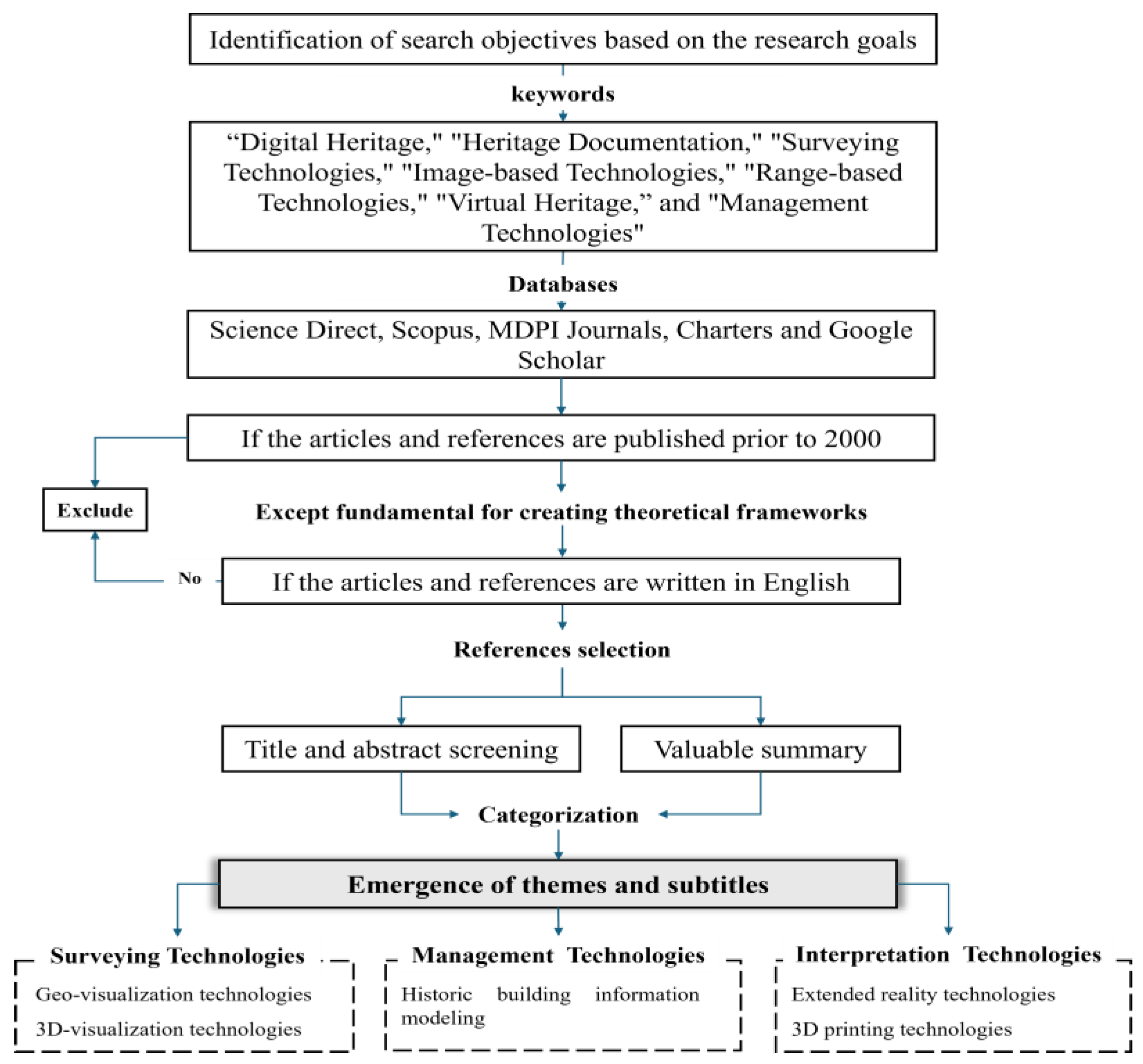
Figure 2.
Digital heritage documentation technologies classifications. Source: Authors.
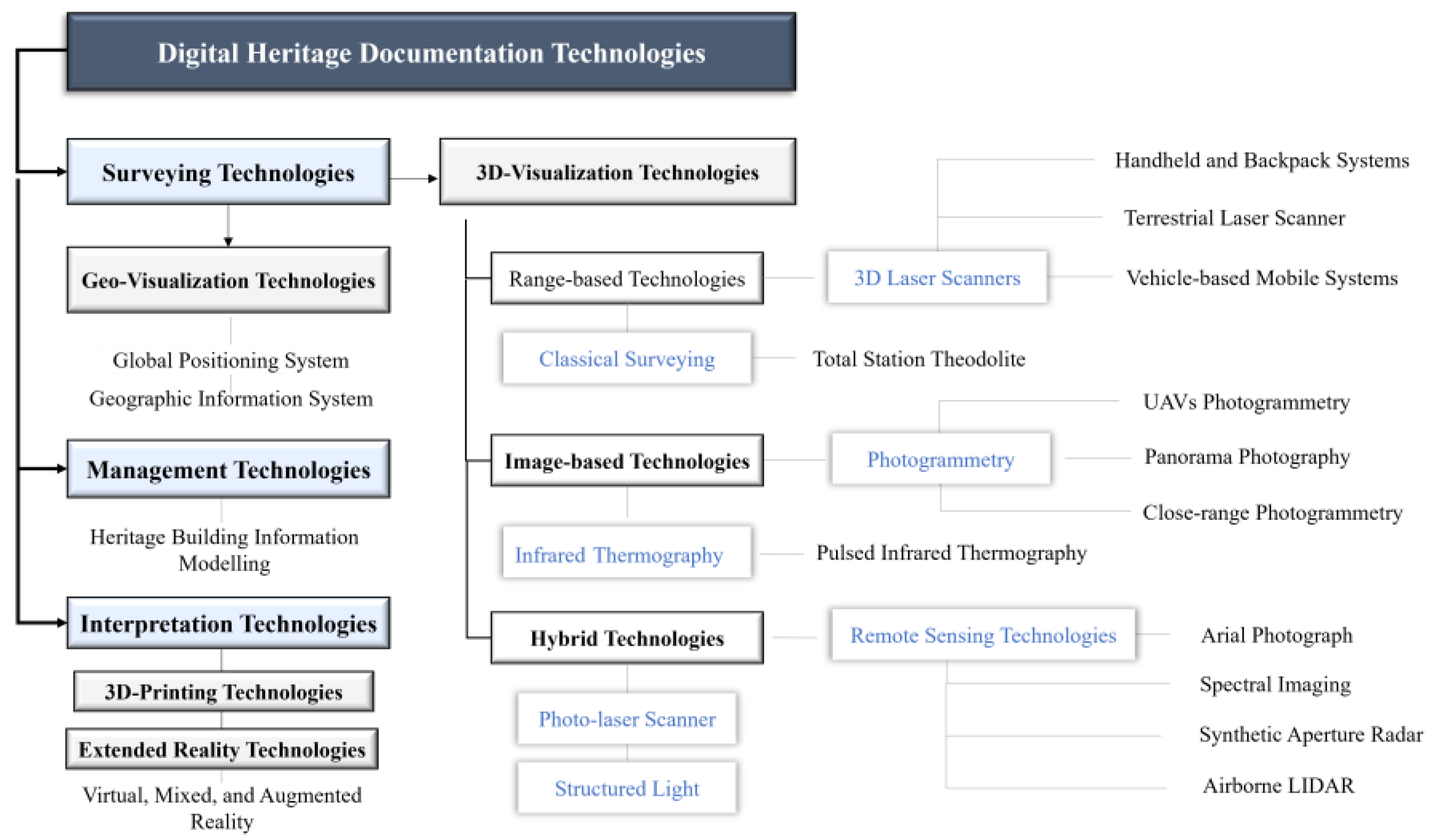
Figure 3.
(a) Digital recreation of the temple exterior. Source: [41]; (b) Current situation of the temple exterior. Source: [41].
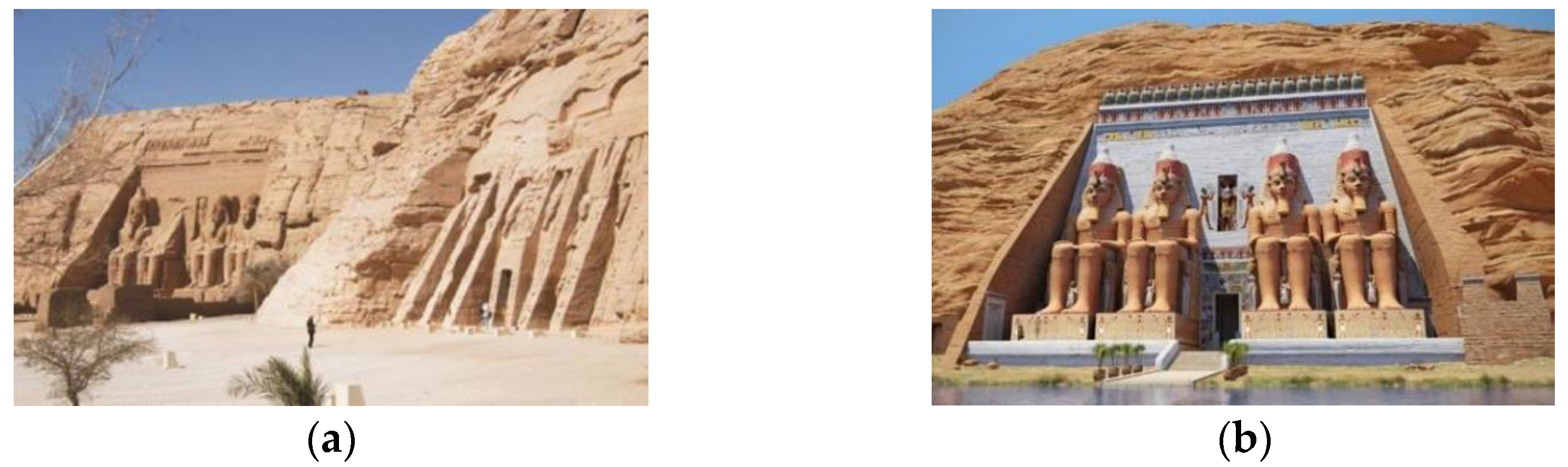
Figure 4.
Zamani Project website of Petra digitalization. Source: [44].
Figure 4.
Zamani Project website of Petra digitalization. Source: [44].
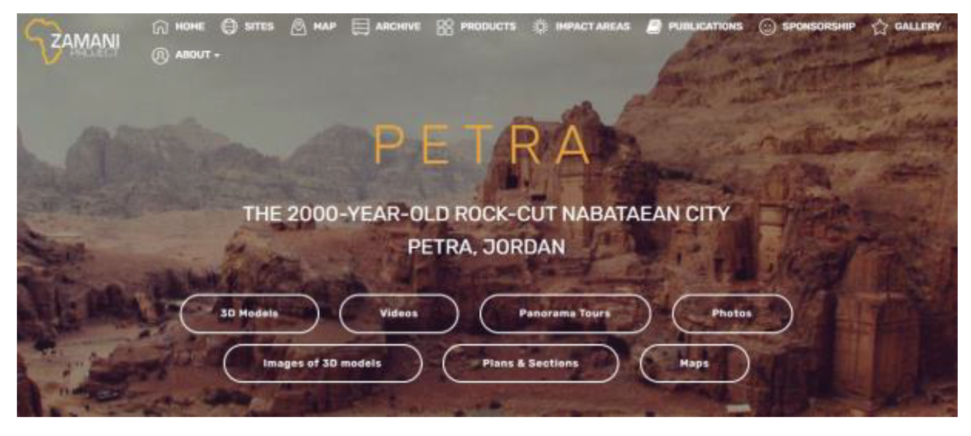
Figure 5.
(a) Base map for the Valley of the Colosseum and the Palatine Hill. Source: [49]; (b) Acquisition instrument and panoramas. Source: [48].
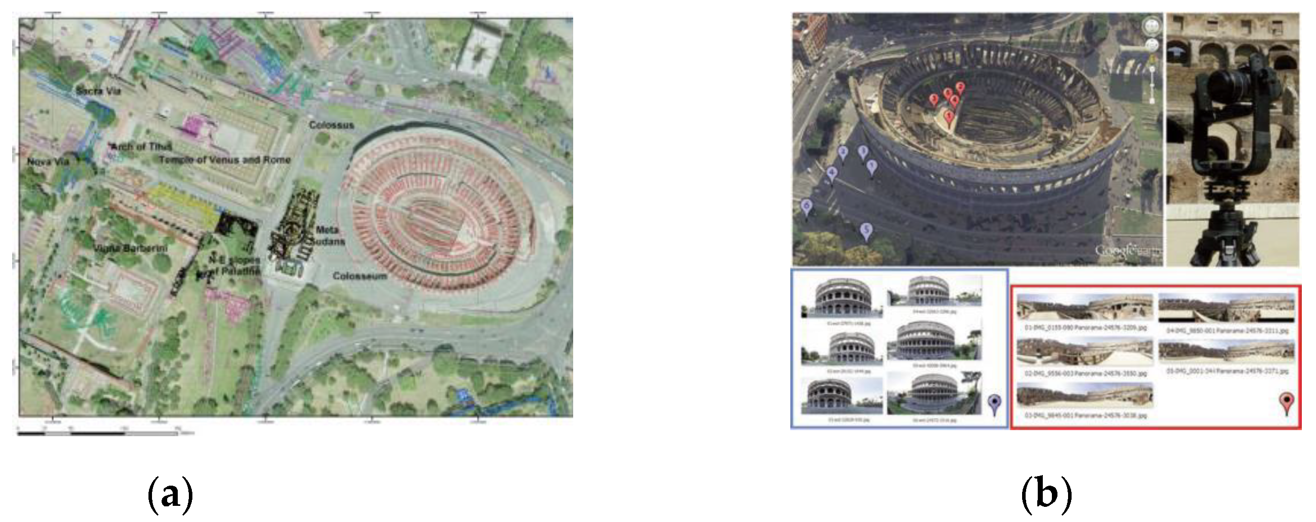
Figure 6.
(a) UAV for surveying the exteriors; (b) Scanning station inside the Tower. Source: [56].
Figure 6.
(a) UAV for surveying the exteriors; (b) Scanning station inside the Tower. Source: [56].
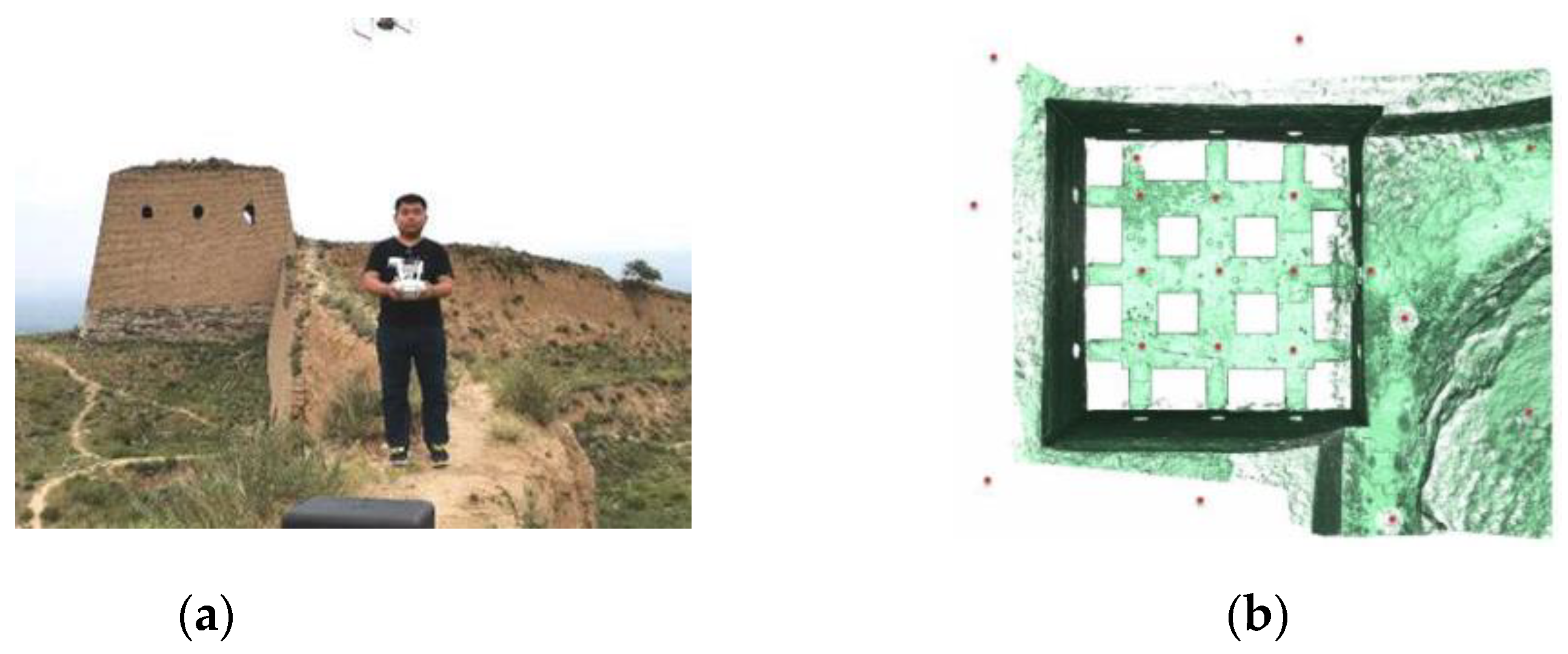
Figure 7.
Heritage digitalization stages. Source: Authors.
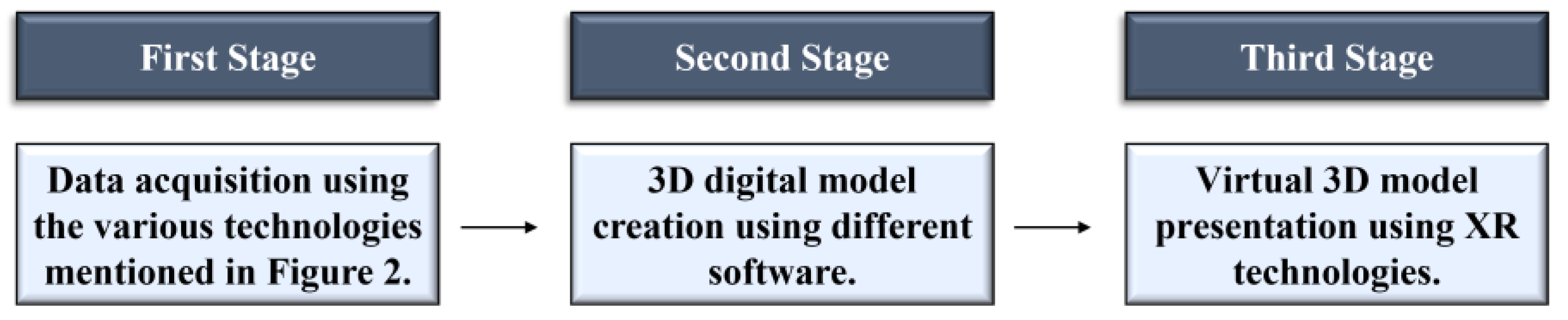
Figure 8.
Smart heritage management concept. Source: Authors.
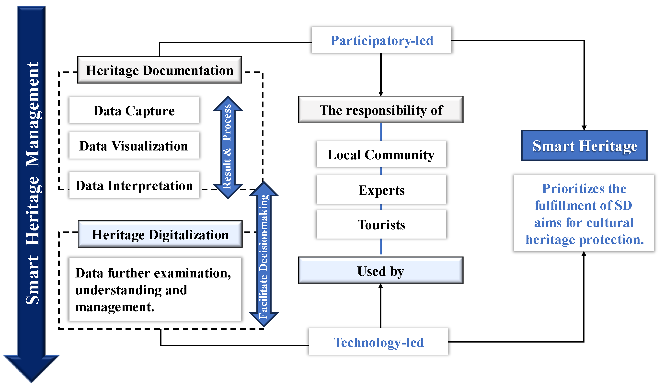
Figure 9.
Smart heritage management dimensions. Source: Authors.
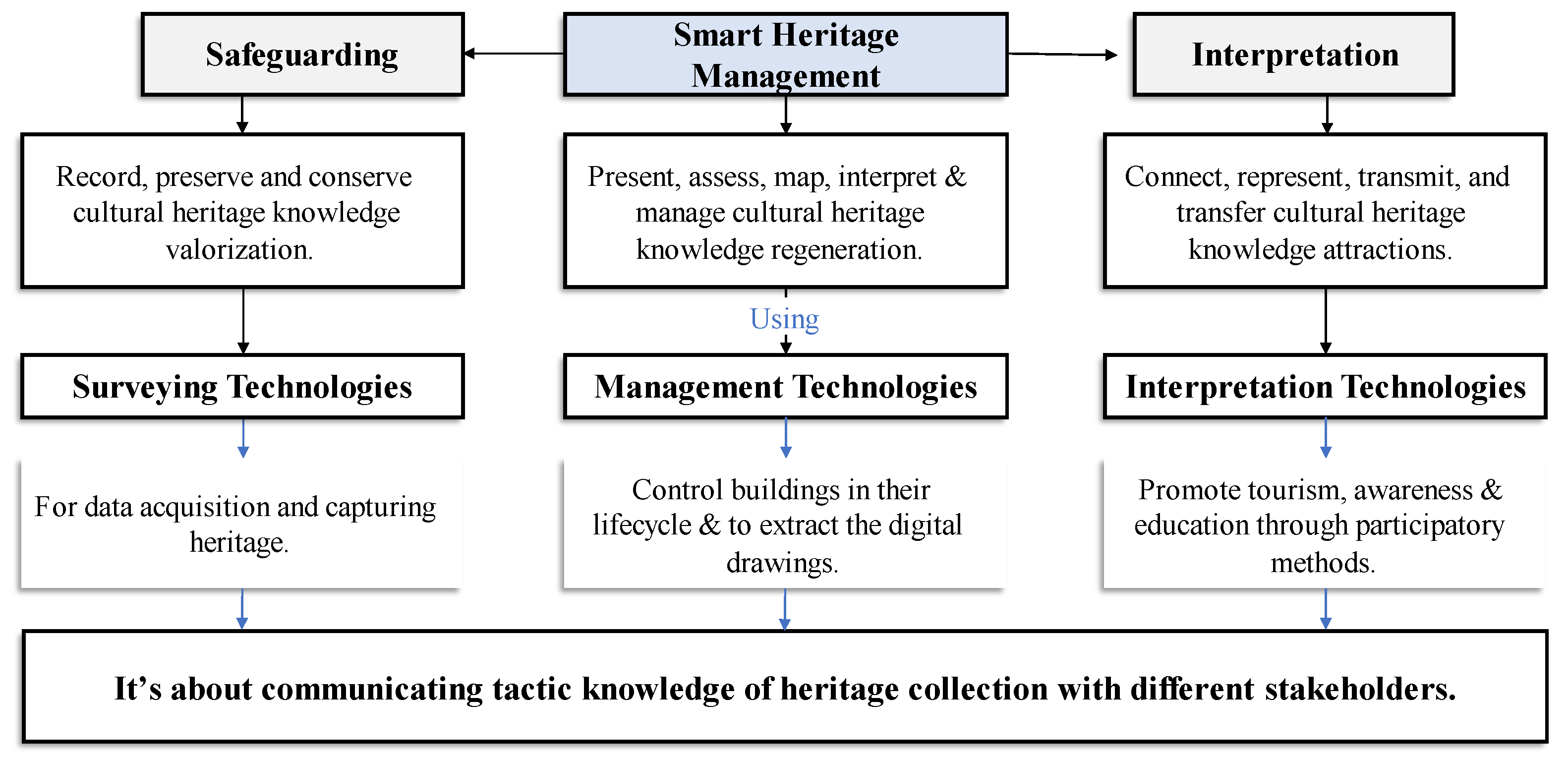
Figure 10.
The components of SCHM. Source: Authors.
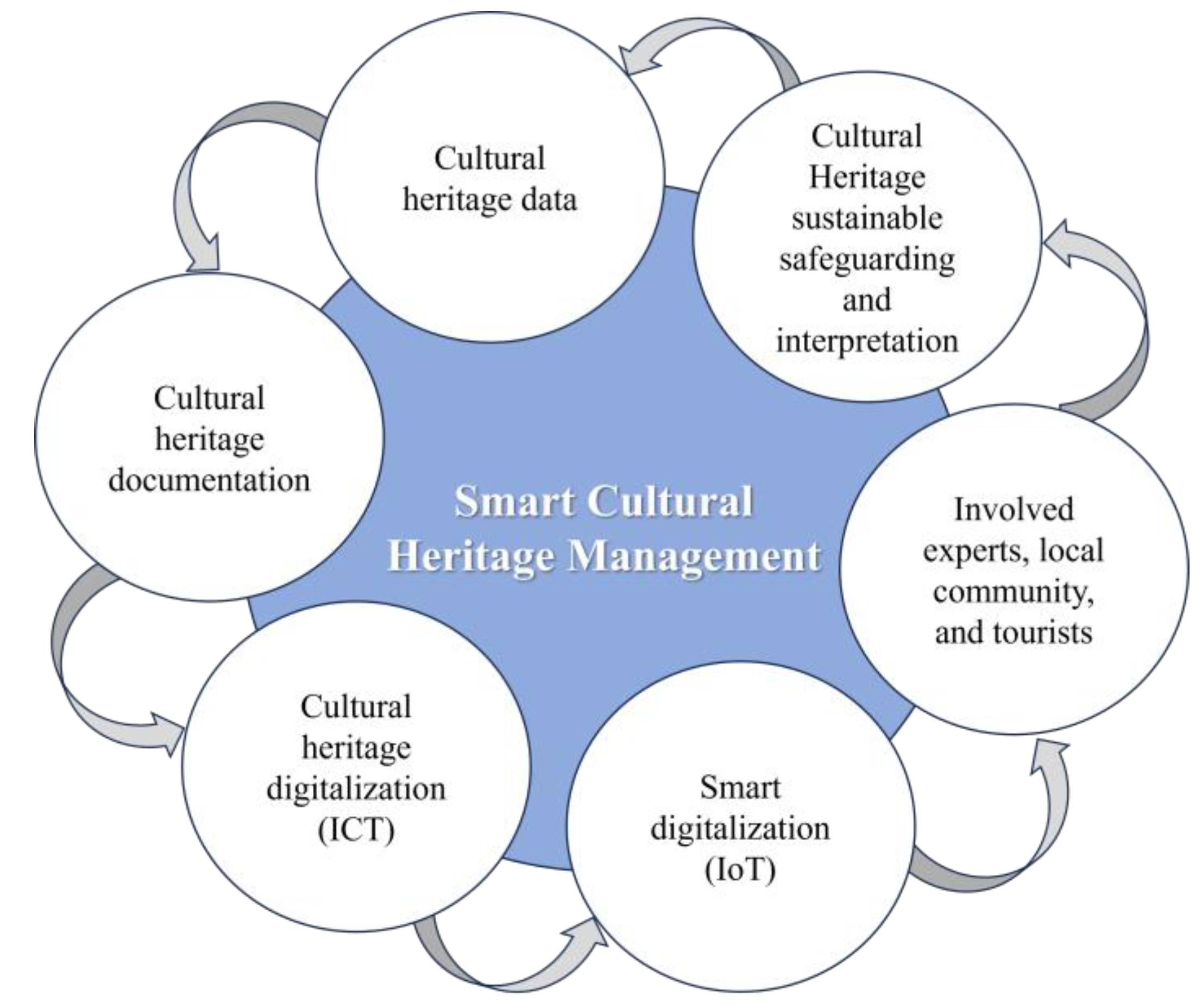

Table 1.
The various technologies used in the digital documentation of the Temple of Abu Simbel. Source: Authors.
Table 1.
The various technologies used in the digital documentation of the Temple of Abu Simbel. Source: Authors.
| Operation | Technology | Characteristics | Parts | Objective | Source |
|---|---|---|---|---|---|
| Surveying | Laser scanner |
Fast, full-density scans with high precision, safe and non-destructive |
The whole temple |
To acquire accurate geospatial data in dry and harsh weather circumstances |
[41] |
| Photo-laser scanner |
Captures six images in all directions |
To create panoramic views and acquiring the color information | |||
| GPS |
Gives precise geodetic coordination |
To provide a geo-referenced model |
|||
| Terrestrial Laser Scanner (TLS) |
Precise and accurate data in windy weather |
To define distances and angels to position coordinates in space | |||
| Management | BIM | Imports data from different software like AutoCAD |
To generate 3D model, map the object category with its properties | ||
| Interpretation | VR and AR | Generates realistic interactive panoramas and deals with text, audio, and video | To create a virtual tourism, increase awareness, and aid in the future restoration |
Table 2.
The various technologies used in the digital documentation of Petra. Source: Authors.
| Operation | Technology | Characteristics | Parts | Objective | Source |
|---|---|---|---|---|---|
| Surveying | TLS | Gives the needed high accuracy, it could be carried by donkeys and horses, non-destructive |
The Siq and Al-Khazneh, the Great Temple, Qsar Al Bint, the Byzantine Church, the Royal Tombs, the Triclinium, Soldiers Tomb, Renaissance Tomb, Garden Tomb, and Columbarium |
To capture the walls geometry and their details (niche and water channels, floor stones) | [44] |
| GPS | Gives precise coordination |
For geo-referencing at the end of the Siq |
|||
| Close range and spherical photogrammetry |
Creates a view available in all directions |
To obtain a detailed image of the rock wall textures |
[43] |
||
| Arial Photograph | Gives textured data with high resolution |
Site Terrain | To obtain a detailed terrain model |
[45] |
|
| TLS | Acquire color information |
||||
| GPS | Georeferencing | ||||
| Management | GIS | Geospatial programs used to incorporate all data in one platform |
Petra archaeological park area |
To store, analyze, and manage the data for Petra archaeological park |
[45] |
| Interpretation | VR and AR | Deals with text, audio, and video |
Virtual tour of Petra |
To promote education, analysis, and tourism |
[45] |
Table 3.
The various technologies used in the digital documentation of the Colosseum. Source: Authors.
Table 3.
The various technologies used in the digital documentation of the Colosseum. Source: Authors.
| Operation | Technology | Characteristics | Parts | Objective | Source |
|---|---|---|---|---|---|
| Surveying | LIDAR | Gives high accuracy |
Colosseum | To create 3D digital models of the Colosseum |
[50] |
| Panoramic photos and Spherical photogrammetry |
Low cost, great speed of execution, and high-resolution |
To create an image-based model |
[48] | ||
| Arial photograph |
Covers wide and high-altitude area |
Colosseum and the surrounding valley | To extract a clear orthophoto map |
[49] | |
| TST | Enriches the process of Geo-referencing |
To conduct a topographic survey |
[47] | ||
| GPS | Geo-referencing of every single point |
To obtain land points to create spatial maps |
|||
| GIS | Combines the data in different layers and creates a spatiotemporal map | To produce thematic maps, architecture typology and other chronology data |
[49] | ||
| Interpretation | VR and AR | Provides interactive provides friendlier interface |
Colosseum and the surrounding valley | To visualize the reconstructed monuments |
[48] |
Table 4.
The various technologies used in the digital documentation of the Parthenon.
| Operation | Technology | Characteristics | Parts | Objective | Source |
|---|---|---|---|---|---|
| Surveying | Aerial photogrammetry |
Gives clear topographic survey |
Acropolis of Athens site |
To produce an exact and detailed geometry |
[21] |
| GPS and Total Station | For geospatial referencing |
All Parthenon parts |
To provide a geo-referenced model |
[53] | |
| Portable laser scanner | Gives dimensional accuracy with high resolution |
Parthenon frieze blocks and the Caryatids of the Erechtheion status |
To record the inner concavities and folded surfaces rear sides |
[53] | |
| Close range photogrammetry |
Give precision and all necessary details |
To provide color information and to track stone damage |
[21] | ||
| Structured Light | Portable, fast, flexible, and provides details at a high resolution |
Frieze, Mopes, and the Erechtheion |
To digitally create a 3D model with color and texture data |
[53] | |
| Interpretation | AR | Online educational game |
Parthenon interiors and exteriors |
Provides a valuable information by creating an attractive replica for the Parthenon | [54] |
| MR | Online application provides texts and audiovisual material |
Ancient Greek temple and the Parthenon Frieze |
Presents the temples’ function planning, typology, construction, and decoration |
||
| VR | Provide 360 realistic images with high resolution |
Parthenon and the whole acropolis of Athens | To provide a virtual tour to the current station of the acropolis of Athena |
Table 5.
The various technologies used in the digital documentation of the Great Wall of China. Source: Authors.
Table 5.
The various technologies used in the digital documentation of the Great Wall of China. Source: Authors.
| Operation | Technology | Characteristics | Parts | Objective | Source |
|---|---|---|---|---|---|
| Surveying | Aerial photography |
Covers wide and high-altitude area |
The Great Wall |
Surveying work |
[57] |
| Panoramic photos |
High precision |
To produce a digital 3D model |
|||
| UAV | Safe, cost efficient, and accurate |
Towers’ Exterior |
To create a 3D model and to give precise positioning |
[56] | |
| 3D laser scanner with 360 degrees camera |
Precise pointing, accurate data in windy weather, needs few instruments |
Towers’ Interior |
To acquire accurate Measurements and color point clouds |
||
| Interpretation | VR and AR | Technical tool for communication purposes |
The Great Wall |
To recreate the cultural heritage in China and to showcase its cultural relics |
[57] |
| MR | Handmade Planet is a Tencent sandbox game to provide visual information |
To raise public awareness and accessibility |
Table 6.
The various technologies used in the digital documentation of the Notre-Dame de Paris Cathedral. Source: Authors.
Table 6.
The various technologies used in the digital documentation of the Notre-Dame de Paris Cathedral. Source: Authors.
| Operation | Technology | Characteristics | Parts | Objective | Source |
|---|---|---|---|---|---|
| Surveying | Handheld optical tracked laser scanning system. |
High resolution and precision |
South façade | To illustrate variations in stone types and surface treatment as well as letter forms |
[59] |
| Photogrammetry | Gives texture and color details |
Whole Cathedral |
To document the destroyed parts and obtain other needed data for the model |
[60] | |
| TLS | Gives accurate and high-resolution measurements |
To create the dense point cloud which used to generate the 3D digital model |
|||
| Management | BIM | Captures scans to create 3D models, collaborative network | Whole Cathedral |
To produce a digital archive of historical documents to strengthen its resilience |
[61] |
| Interpretation | AR |
Gives all angles views and enables the selection of detailing level, allows for moving virtual objects |
Whole Cathedral |
Notre-Dame de Paris, the Experience intends to revive the cathedral’s history and to explore 3D reconstructions |
[62] |
| VR | Technical tool for communication purposes |
Observes the restoration process from an insider's perspective |
|||
| 3D printing | Gives details and deals with complicated design |
Sculptures | Creates a 3D realistic model from the site remaining parts |
[63] |
Table 7.
Heritage digitalization technologies SWOT survey. Source: Authors.
| Technology | Strength | Weakness | Opportunities | Threats | Source | ||||
|---|---|---|---|---|---|---|---|---|---|
| Classical | |||||||||
| Total Station Theodolite (TST) |
Low-cost technique |
Consumes time |
on-site and buildings surveys |
Complex geometries with non-linearly ruins | [8,28,29,31,65,66] |
||||
| Provides high accuracy |
Needs skilled operators |
Measures vertical, horizontal angles, and sloping distances |
Cannot be completed at the office without survey data |
||||||
| Integrates with geospatial software |
Inefficient in large areas |
Produce 2D thematic maps and a 3D model |
|||||||
| Portability issues | |||||||||
| Limited flexibility and applicability in small areas |
|||||||||
| Laser Scanner | |||||||||
| Terrestrial Laser Scanner (TLS) |
High degree of data acquisition speed and accuracy |
Limited capability in acquiring texture and color data |
Surveys simple objects and massive, intricate buildings |
Affected by lighting, weather conditions, and the surrounding environment |
[6,8,22,27,29,67,68,69] | ||||
| Simple technique |
Costly technique |
Efficient in surveying complex forms |
Hidden or obstructed areas issues |
||||||
| Integrates with geospatial software |
Needs a large memory card |
Provides data in a variety of forms |
Health and safety consequences |
||||||
| Portability and flexibility issues |
|||||||||
| Vehicle-based mobile systems | Mobility |
Large size |
Used to survey historical streetscape areas | Affects the sensitive heritage sites |
[28,67] | ||||
| Simplicity | Noisy | ||||||||
| Handheld and backpack systems |
Simple technique |
Relatively high cost | Collecting data from inaccessible areas |
Safety constraint while using laser source |
[28,67] | ||||
| Accuracy | Complex fieldwork | ||||||||
| Mobility | |||||||||
| High data acquisition rate |
|||||||||
| Photogrammetry | |||||||||
| Panorama Photography |
High capacity for capturing information |
Daylight, shadows consequences, and clean atmosphere | Utilized for heritage interpretation and tourism promotion | Needs to be stored in a large memory |
[8,18,48,70,71,72] | ||||
| Simplicity and affordability |
Needs a special processing software |
Create realistic, interactive replicas |
Camera properties affect quality | ||||||
| Time saver | Low data acquisition rate |
||||||||
| Attractive and high-resolution results | |||||||||
| Integrates with geospatial software | |||||||||
| Close-range Photogrammetry |
Safe and secure option |
Photos should be scattered around the surface |
Utilized in sites with limited accessibility |
Camera properties, influence the outcome quality |
[6,8,31,33,67,73,74] | ||||
| Cost-effective | Sophisticated system |
Covers heritage sites, buildings, interiors, and small objects | Physical obstacles could limit its applicability |
||||||
| Deals with different levels of complexity efficiently | Needs skilled people |
Affected by the distance between the camera and the target |
|||||||
| Offers vector and metric data |
Uniform textures constitute a real issue |
Affected by the atmospheric circumstances |
|||||||
| Gives color and texture details |
Sparse data coverage |
||||||||
| Unmanned Aerial Vehicles (UAVs) Photogrammetry |
Low equipment cost |
Short battery life |
Used to survey heritage sites | Needs Pilot accreditation |
[8,10,18,21,25] | ||||
| Time efficient and safe technique | Needs costly software |
Create a highly accurate 3D model |
Privacy invasion and legislation |
31, 73, 75,76, 77, 78] | |||||
| Obtain high-spatial-resolution data | Maintenance costs |
Used for low-budget projects | Restricted airspaces |
||||||
| Covers dangerous and inaccessible areas |
Hindered by weather conditions, darkness, and obstacles | Complex information processing |
|||||||
| Different UAVs typologies |
|||||||||
| Infrared Thermography (IRT) | |||||||||
| Pulsed infrared thermography |
Combines 3D models and RGB images | Needs a high level of skilled users |
Used to examine the state of the objects | Complex information processing | [6,8,79,80,81] | ||||
| High accuracy, mobility, and real-time interpretation |
Analyzes objects compositions |
||||||||
| Hybrid | |||||||||
| Photo-laser scanner |
High-quality and textured 3D digital models |
Relatively high cost |
Accuracy while recording an object’s edges and cracks |
Complex information processing |
[8,82] | ||||
| Fast, accurate, and efficient technique |
Needs additional Equipment and specialized software |
Survey complex objects with color and texture details |
Large amount of data |
||||||
| Structured Light |
High-accuracy 3D model in a short time | Need skilled users and operators |
Surveys small and medium-sized objects | Complicated software system |
[8,69] | ||||
| Offers several types |
Used in narrow spaces | ||||||||
| Safe, simple and cost-efficient technique | |||||||||
| Aerial Photograph |
Survey of large areas within a short time |
Low spatial resolution |
Provides a bird's- eye view of the heritage sites |
Affected by lack of coordinates and lens distortion |
[83] | ||||
| Relatively low cost |
Print quality issues |
Captures and detects the small changes in the earth’s surface | |||||||
| Integrates with other technologies |
Upgradability | ||||||||
| Spectral Imaging | Detect compositional changes, uncover underdrawings, and expose prior conservation treatments |
Creating 3D object requires its integration with other 3D imaging techniques |
Records the state of the object, guide its maintenance, and improve its scientific knowledge | Obstacles present, image degradation, and spatial resolution, affect its capabilities |
[83] | ||||
| Synthetic Aperture Radar |
High spatial resolution for wide spatial coverage | Requires skilled workers |
Detects buried heritage sites in various regions |
Complicated information processing |
[83,84] | ||||
| Cost-effective and efficient technique |
Monitors deformation and natural hazards | ||||||||
| Works in all weather conditions or at night | Detects the anthropogenic actions |
[83] | |||||||
| Airborne Light Detection and Ranging (LIDAR) |
High rate of data acquisition from large area in seconds |
Requires skilled workers |
Allows to record, document, and monitor heritage sites |
Its accuracy affected by various obstacles | [8,29,83] | ||||
| Realistic surface models |
Expensive | Works on both landscape and site scales |
GNSS inaccuracies and noise can affect its systems | ||||||
| high-quality and accurate data |
High density data |
||||||||
Table 7.
Correlation between heritage digitalization technology and scale. Source: Authors.
| Technologies | Spatial Scale | ||
|---|---|---|---|
| Object Scale/Interiors* | On-site Scale* | Off-site Scale* | |
| Surveying | |||
| GIS | Limited applicability | High applicability | Highest applicability |
| GPS | Limited applicability | In open-to-sky areas | In clear sites with no obstacles |
| TST | Applicable | Applicable | Not applicable |
| 3D-laser Scanning |
Covered by handheld scanners | Covered by TLS | Covered by airborne laser scanners |
| Photogrammetry | Covered by spherical and close-range photogrammetry |
Covered by spherical and close-range photogrammetry |
Covered by aerial photogrammetry using UAVs technology |
| IRT | Highest applicability | High applicability | Not applicable |
| Photo-laser Scanner |
Highest applicability | High applicability | Not applicable |
| Structured Light | Highest applicability | High applicability | Not applicable |
| RS Technologies | Covered by Spectral Imaging |
Covered by arial photograph and LIDAR technologies |
Covered by arial photograph, SAR, and LIDAR technologies |
| Management | |||
| BIM | High applicability | High applicability | Applicable |
| Interpretation | |||
| XR | High applicability | High applicability | Applicable |
| 3D Printing | Highest applicability | High applicability | Applicable |
(1) Object Scale: encompasses artefacts, statues, certain building features or parts. (2) On-site scale: encompasses entire building or a building certain surface like facades. (3) Off-site scale: encompasses entire landscape.
Disclaimer/Publisher’s Note: The statements, opinions and data contained in all publications are solely those of the individual author(s) and contributor(s) and not of MDPI and/or the editor(s). MDPI and/or the editor(s) disclaim responsibility for any injury to people or property resulting from any ideas, methods, instructions or products referred to in the content. |
© 2024 by the authors. Licensee MDPI, Basel, Switzerland. This article is an open access article distributed under the terms and conditions of the Creative Commons Attribution (CC BY) license (http://creativecommons.org/licenses/by/4.0/).
Copyright: This open access article is published under a Creative Commons CC BY 4.0 license, which permit the free download, distribution, and reuse, provided that the author and preprint are cited in any reuse.


