Submitted:
02 September 2024
Posted:
04 September 2024
Read the latest preprint version here
Abstract
Dhaka one of the fastest-growing megacities in the world is increasingly vulnerable to urban flooding due to rapid urbanization, inadequate drainage infrastructure, and climate change-induced extreme weather events. This study presents the development of an urban flood forecasting system for Dhaka City using the MIKE+ hydrodynamic modeling software. The system integrates detailed hydrological and hydraulic models to simulate urban flooding scenarios, accounting for complex drainage networks and catchment characteristics. Real-time data from river gauges, rainfall stations, and drainage systems are incorporated to enhance the accuracy and reliability of the forecasts. The model's predictive capability is validated against historical flood events, demonstrating its effectiveness in forecasting flood extents, depths, and durations in critical areas of the city. This system serves as a valuable tool for city planners, emergency response teams, and decision-makers, enabling proactive flood management and risk mitigation. The study underscores the importance of such advanced modeling tools in safeguarding urban populations and infrastructures from the increasing threat of urban floods in Dhaka and similar rapidly urbanizing cities.
Keywords:
Urban Flood
; Dhaka
; MIKE+
; Real-time flood forecasting
; Hydrodynamic modeling
1. Introduction
Climate change is likely to have consequences in hydrology, including extreme rainfall and changing precipitation patterns[1,2,3]. These changes can lead to more urban floods and adverse effects on existing urban infrastructure[4,5,6]. These effects can lead to loss of property, including utility infrastructure and household assets, as well as human and economic impacts, especially loss of income in various industries and interruptions in trade and transportation[7,8,9]. Urban flooding is a pressing and recurrent issue that plagues many rapidly growing metropolitan areas around the world[10].
Dhaka, the capital of Bangladesh and one of the most densely populated cities in the world is no exception to this critical concern [11,12,13]. Over the past few decades, Dhaka has experienced a substantial increase in population, urbanization, and infrastructure development[14]. While these factors have contributed to economic growth and urban expansion, they have also exacerbated the vulnerability of the city to flooding events [15,16].
Dhaka's urban flooding problem is a multifaceted challenge driven by various interconnected factors, including its geographic location, topography, climate variability, and, most significantly, inadequate urban planning and infrastructure [17,18,19]. Situated in a low-lying deltaic region and crisscrossed by numerous rivers and canals, the city faces heightened susceptibility to inundation during the monsoon season [20]. Moreover, the intensifying effects of climate change have increased the frequency and severity of extreme weather events, compounding the city's flooding woes [21,22].
In this context, the application of urban flood forecasting holds significant promise for Dhaka city. By harnessing cutting-edge technologies and data-driven methodologies, urban flood forecasting offers a proactive approach to managing and mitigating flood-related risks [23,24]. Accurate and timely flood forecasts can provide city authorities, emergency responders, and the general populace with essential information to prepare for impending floods, thereby helping to minimize damages, safeguard lives, indicate waterlogged areas for traffic, and thus bolstering overall urban resilience [4,8,9,25,26,27].
This study endeavors to delve into the practical application of urban flood forecasting within the unique context of Dhaka city. Through an in-depth analysis of the city's geographical intricacies, hydrological dynamics, and technological capacities, this study aims to explain the potential benefits, challenges, and opportunities associated with implementing urban flood forecasting systems for Dhaka. By exploring the efficacy of such systems in Dhaka, we aspire to contribute to the broader discourse on urban flood management strategies, offering insights that may be applicable to other rapidly urbanizing regions grappling with similar hydrological vulnerabilities. Ultimately, this study seeks to underscore the significant role of urban flood forecasting in enhancing disaster preparedness and resilience, thereby promoting sustainable urban development in Dhaka.
This study seeks to explore the causes, consequences, and potential mitigation strategies for addressing this critical problem. By examining the various dimensions of urban flooding in Dhaka, we can gain valuable insights into the challenges faced by rapidly growing cities in developing nations and contribute to the development of effective flood management and resilience-building strategies. In doing so, we hope to provide a foundation for evidence-based policy decisions and urban planning practices that can help Dhaka and similar cities mitigate the impacts of urban flooding and enhance their long-term sustainability and resilience.
2. Study Area
Geographically, the core area of Dhaka metropolitan city lies between 23.69° and 23.89° North latitudes and 90.33° and 90.44° East longitudes [28] in Figure 1. The core city covers about 261.67 km2 of land area[29].
The study area of Dhaka city presents a unique and challenging landscape characterized by complex hydrological features, an intricate drainage network, and recurrent urban flooding problems [4,13,16,19]. This section provides an overview of these aspects, shedding light on the critical issues that define the hydrological dynamics and flooding challenges in the city. This geographical location exposes the city to the inherent dynamics of a deltaic environment, making it susceptible to both riverine and rainfall-induced flooding [30]. The hydrology of Dhaka is heavily influenced by the following key factors [15,31,32].
River Systems: The city is traversed by numerous rivers, canals, and water bodies, which play a crucial role in its hydrological regime [33,34]. The city is surrounded by six interconnected river systems- Buriganga, Dhaleswari in the south, Turag and Tongi Khal in the North, Balu and Sitalakhya in the east. These waterways exhibit substantial variations in water levels, especially during the monsoon season, when they are prone to overflowing their banks and inundating adjacent areas, especially the eastern part of Dhaka as it is not embanked like the western part of Dhaka [21,34].
Monsoon Rainfall: Dhaka experiences a monsoon climate with heavy and concentrated rainfall during the wet season. This seasonal high concentrated rainfall (Figure 2) significantly contributes to the city's flooding, as inadequate drainage systems struggle to cope with the rapid influx of rainwater [36,37].
Climate Change: The intensifying impacts of climate change, such as altered rainfall patterns and increased frequency of extreme weather events, have further exacerbated the city's hydrological vulnerabilities [36,37,38].
Drainage Network: The drainage network in Dhaka city is a complex cobweb of canals, stormwater drains, and sewers designed to manage surface water runoff. This drainage system is divided into 20 zones (Figure 7). However, several challenges hinder its effectiveness: (1) Inadequate Infrastructure: The rapid urbanization of Dhaka has outpaced the development of its drainage infrastructure. Many areas lack proper stormwater management systems, leading to waterlogging and urban flooding. (2) Encroachment and Land Use: Encroachment upon natural drainage paths and changes in land use, including the widespread concretization of surfaces, have disrupted the city's natural drainage patterns. (3) Siltation: Siltation in canals and water bodies reduces their capacity to carry water, contributing to localized flooding during heavy rainfall.
Flooding Problem: The recurring flooding problem in Dhaka city manifests in various ways: (1) Waterlogging: Prolonged waterlogging, especially in low-lying areas, disrupts daily life, affects transportation, and poses health risks to residents. (2) Infrastructure Damage: Flooding causes damage to roads, bridges, buildings, and utility infrastructure, leading to significant economic losses. (3) Human Displacement: Residents of flood-prone areas are often relocated during floods, with adverse social and economic consequences. (4) Health Risks: Stagnant floodwater can lead to the spread of waterborne diseases, posing a health hazard to the population.
In summary, the study area of Dhaka city presents a hydrologically complex environment characterized by intricate drainage challenges and persistent urban flooding issues. Understanding these dynamics is essential for developing an effective flood forecasting system and enhancing the city's resilience to future flooding events.
3. Approach, Methodology and Data Collection
The approach adopted in the current research for developing the urban flood forecasting system for Dhaka city is conceptually shown in Figure 3. The main steps of the proposed methodology include: (1) Data collection; (2) Development of Rainfall-Runoff Model; (3) Development of a 1D river+collection model coupled with Rainfall-Runoff model and its calibration; (4) Development of a 2D overland flow model, including assessment of 2D area’s roughness derived from land use and land cover classification via image processing; (5) Coupling of the 1D–2D models and sensitivity analysis of various modeling parameters and (6) Simulation the first four steps with forecasted rainfall for generating next 24 hours flood scenario in the Dhaka city.
3.1. Data Source:
Extensive primary and secondary data have been collected to develop an urban flood forecasting model. Meteorological data including rainfall, evaporation (monthly historical), temperature (monthly historical), and hydrological data such as water level and discharge have been collected. Additionally, topographical information including land levels and cross-sections of drainage khals, sewerage network details, and information on drainage structures such as regulators and pumps, have been obtained. Infrastructure data including roadways, railway levels, and flood protection embankments have also been included. All secondary data were meticulously checked using the standard procedure to ensure accuracy. To further enhance the model's precision and validate secondary data, primary data such as structural information and topographic surveys in Dhaka city were conducted. Several field visits were conducted to oversee the quality control of survey procedures and verify the model. Under this study spot-level (Figure 4) data is collected for correcting the existing DEM data of Dhaka.
3.2. Cross-Section Data
In the MIKE+ river and collection system, the computational domain is represented as a series of cross-sections perpendicular to the flow direction [39,40]. To develop a 1D hydrodynamic model for Dhaka City, cross-sectional surveys of rivers and canals in the region have been conducted. Depending on field conditions, these surveys were carried out using either leveling instruments combined with sounding, echo sounders, or a combination of both. A total of 174 cross-sections from 11 different rivers and canals in and around Dhaka City were collected through field surveys, while an additional 169 cross-sections were obtained from the IWM database and other sources, as detailed in Table 1 and Figure 5.
3.3. Weather Data:
Several organizations produce weather forecasts for Dhaka City using simulations of numerical weather models. The Bangladesh Meteorological Department (BMD) simulates the Weather Research and Forecasting (WRF) model to produce numerical weather predictions with a horizontal resolution of 3 km and a temporal resolution of 3 hours [41]. In contrast, other models provide forecasts at much coarser resolutions. BMD's weather forecast is generated for three days, though the accuracy decreases with increasing lead time. 24-hour BMD forecast is typically used in our study model to predict the flood situation for the subsequent 24 hours. An example of a one-day forecast is illustrated in Figure 6.
3.4. Rule Curve of Pump Opertion
There are four major pump stations in the Dhaka city. All these pump stations have their own command area and specific rule curves. These rule curves are collected from the associate authority and incorporated into the model. The main purpose of these pump stations is to drain out the domestic water and runoff from the countryside to rivers. Figure 5 shows the pump locations, command area and the connection with peripheral rives.
3.5. Pipe Network and Manholes:
160.1 km meter pipe network and 1161 nos manhole data are collected from Dhaka WASA and Dhaka Noth and South City Corporation. The Efficiency of pipe networks based on the field observations is adjusted in the models. All manholes with different diameters are connected to the 2D domain that are shown in the Figure 5, 7 and 12.
3.6. Canal Network:
A total of 120.25 km canal network including dimension has been collected from the associate authority and incorporated into the model. Figure 5 and 12 are showing the canal distribution in the model.
3.7. Water Retention Pond
All pump stations have their own retention pond. These retention ponds carry stormwater runoff and domestic water of residential areas and support wastewater treatment and prevent flooding. These retention ponds are included in the 2D domain by interpolation of survey spot level inside the retention ponding area. Retention ponds are connected to the pump stations and corresponding drainage canals and internal khals using standard link in the model. All retention ponds are showed in the Figure 5.
3.8. Hydraulic Structure
Khals inside Dhaka city is controlled by the different types of hydraulic structures, embankment crest level (Figure 8), and pump stations. Various types of information about existing structures like invert level, gate height etc., have been collected from the field. The structural information incorporated into the model is shown in Figures 7 and 12.
4. Model Development
The study relies on a combined approach of numerical modeling and GIS. The urban model of Dhaka City is a 1D-2D coupled model comprising three components: Rainfall -Runoff, 1D Hydrodynamic, and 2D Overland flow model. The three models have been integrated together and developed a 1D-2D coupled model of the study area. The models have been developed using MIKE+ software of the Danish Hydraulic Institute (DHI), Denmark [42]. 1D Hydrodynamic module simulates the river and collection system (pipes and drainage network), Rainfall-Runoff module simulates the local runoff generated by the rainfall, and the 2D overland flow module simulates the flood propagation, inundation depth and flow velocity. The interaction among all the components is modeled in a MIKE+ platform which allows quick integration and detailed representation of free-surface flows over the streets.
The total area of Dhaka city is around 261.67 sq. km. Drainage khal, manhole, drainage pipe, river, flood embankment, roads, hydraulic control structure etc., are main the features which have been included in the urban flood model. Considering all features, model domain, and complex water collection system of Dhaka city, the model has been developed step by step taking one drainage zones of Dhaka city at a time. Dhaka drainage system is divided into 20 drainage zones (Figure 7) all of which have been added to the model.
4.1. Conceptual Background of Urban Flood Model:
MIKE+ (it is a new generation urban flood modelling tool developed by DHI) is a flexible system for modelling and design of water distribution networks, collection systems for wastewater and storm water and river networks with interaction of 2D overland flow (Figure 9). Within the "Rivers, collection system and overland flows" working mode in MIKE+, the following features (those are needed to capture the dynamics of urban flood) are activated:
- Catchments
- Collection system network
- River network
- 2D overland
4.2. Rainfall Runoff Model
The RR module simulates hydrological processes on catchments. Hydrological model has two distinct classes of models.
4.2.1. Surface Runoff Model
These are the most common types in urban runoff analysis. The common characteristic of all the models in this class is that only surface runoff is computed. This implies discontinuous runoff hydrographs where the flow starts as a result of rainfall and reduces to zero again after the end of rainfall. As such, these models are suitable for relatively densely urbanized catchments with a dominant amount of runoff generated on impervious surfaces, and for single-event analyses (e.g., design rainfall of certain recurrence intervals). These models fail to provide realistic results in dominantly rural catchments and for long-term analyses involving multi-event rainfall series.
4.2.2. Continuous Hydrological Model
These models treat the precipitation volume balance without any truncation through complex concepts. As a result, the generated runoff includes both the overland and subsurface runoff components. Due to the longer time scales involved, the runoff hydrographs appear practically continuous. An important property of continuous hydrological models is hydrological memory, i.e., the ability to simulate the catchment reaction to certain rainfall dependent on previous rainfalls. This type of model is essential for any long-term analysis and dominantly rural catchments. On the other hand, these models are usually incapable of simulating extremely fast response of heavily impermeable urban catchments.
MIKE+ includes a series of surface runoff models and one continuous hydrological model. The surface runoff models available are:
- Time-Area Method (A)
- Kinematic Wave (B)
- Linear Reservoir (C1 and C2)
- Unit Hydrograph Method (UHM)
The continuous hydrological model used in this study is Rainfall Dependent Infiltration (RDI). Any of the surface runoff models can be used on their own, or in combination with RDI. When a surface runoff model is combined with RDI, the simulation will compute the runoff for each method (surface runoff model and RDI) separately as if they were different catchments and will then sum the runoff of the surface runoff model and RDI model. Combining different models for individual catchments in one runoff computation is also possible in MIKE+.
4.2.3. Time-Area Method (A) for Surface Runoff Model
In the Time-Area surface rainfall-runoff method, the amount of runoff is controlled by the initial loss, the size of the contributing area, and a continuous hydrological loss. Water balance (right amount of water) is controlled by the reduction factor and initial loss. Moreover, a snow storage may also be added to the computation. The shape of the runoff hydrograph/flow routing is controlled by the concentration time and by the time-area (T-A) curve shape. These two parameters represent a conceptual description of the catchment reaction speed and the catchment shape. Depending on basin Characteristics (% of Impervious area) and hydrological parameters (Initial Loss, Hydrological Reduction (mainly evapotranspiration) and Time/Area Curve), Time-Area surface model simulates the surface runoff.
A time-area curve characterizes the shape of the catchment, relating the flow time i.e., concentric distance from the outflow point and the corresponding catchment sub-area. Irregularly shaped catchments can be more precisely described by the user-specified T/A curves or coefficients. The concept of the time area model to generate runoff of catchment is given below in Figure 10.
4.3. Conceptual Background of MIKE 1D Collection System
The MIKE 1D Hydrodynamic Pipe Flow Model solves the complete St. Venant (dynamic flow) equations throughout the drainage network (looped and dendritic), which allows for modelling of backwater effects, flow reversal, surcharging in manholes, free-surface and pressure flow, tidal outfalls and storage basins.
The MIKE 1D hydrodynamic engine is designed to handle any type of pipe network system with alternating free surface and pressurized flows as well as open channel network and pipes of any shape.
Virtually any construction can be described including pumps, weirs, orifices, inverted siphons, etc. The computational scheme uses an implicit, finite-difference numerical solution of the St. Venant flow equations. The numerical algorithm uses a self-adapting time-step, which provides efficient and accurate solutions in multiple connected branched and looped pipe networks. This computational scheme is applicable to unsteady flow conditions that occur in pipes ranging from small-profile collectors for detailed urban drainage, to low-lying, often pressurized, sewer mains affected by varying outlet water levels. Both sub-critical and supercritical flows are treated by means of the same computational scheme that adapts to the local flow conditions. In addition, flow phenomena, such as backwater effects and surcharges, are precisely simulated. In Figure 11, how the 1D CS (collection system: pipe, canal, manhole, and other structure) network works is illustrated.
4.4. Conceptual Background of 2D Overland Flow
MIKE+ 2D overland module uses DHI's 2D engine MIKE 21 FM. This engine solves the two-dimensional St. Venant (dynamic flow) equations, using a cell-centered finite volume method. The time integration is performed using an explicit scheme and the numerical solution uses a self-adapting time step for optimizing stability and simulation times. The spatial discretization can either be done through a rectangular grid or a flexible mesh. The 2D overland module can be used to simulate free-surface flows to describe detailed flows in channels or describe surface floods from e.g., surcharging collection system networks or rivers.
MIKE 21 Flow Model is a modeling system for 2-D free-surface flows. The two-dimensional model performs simulation on a two-dimensional grid. The two-dimensional grid can be a normal rectangular grid or a mesh. The modeling system is based on the numerical solution of the two/three-dimensional incompressible Reynolds averaged Navier-Stokes equations subject to the assumptions of Boussinesqand of hydrostatic pressure. Thus, the model consists of continuity, momentum, temperature, salinity and density equations and it is closed by a turbulent closure scheme.
The two-dimensional shallow water equations in conservative form can expressed as
Here, t is the time; x and y are the Cartesian coordinates; ℎ = η + d is the total water depth, where η is the surface elevation and d is the still water depth; u and v are the depth averaged velocity components in the x and y direction; f = 2Ωsinϕ is the Coriolis parameter (Ω is the angular rate of revolution and ϕ the geographic latitude); g is the gravitational acceleration; pA is the atmospheric pressure at the free surface; ρ is the density of water; ρ0 is the reference density of water. (τfx, τfy) are the x- and y- components of the stresses due to bottom friction, surface friction and flow resistance. and (τsx, τsy) are the x- and y-components of the surface stresses due to the wind. Fv = (Fvx, Fvy) is the drag force due to vegetation. The lateral stresses, Txx, Txy and Tyy, include viscous friction, turbulent friction, and differential advection. They are estimated using an eddy viscosity formulation based on the depth averaged velocities.
4.5. Conceptual Background of 1D/2D Overland Flow
In the coupled 1D/2D MIKE FLOOD model, the main river stretch is simulated using a 1D approach, while the floodplain is represented with a 2D modeling approach. MIKE FLOOD plays a tight coupling technique, where the 1D and 2D domains are integrated on a time-step basis to ensure consistent interaction between the two domains. The connection between the 1D river model and the 2D floodplain model is established using lateral structures, allowing for an accurate representation of flow exchanges between these domains [45]. The main river stretch is modeled using the 1D Saint-Venant (shallow water) equations, which consist of the continuity and momentum equations, as presented in Equations (4) and (5).
Here, A, Q, S0, and Sf represent the cross-sectional area (m2), water flow rate (m3/s), riverbed slope, and energy slope, respectively. Additionally, flow in the floodplain is computed using the 2D continuity and momentum equations, as provided in Equations (1)–(3).
4.6. Model Setup
In MIKE+, there are three models: a) rivers, collections system and overland flows, b) SWMM5 collections system, and overland flows, and c) Water Distribution. In this study, rivers, collection system and overland flow models have been used. This model can simulate river, canal, or drainage and overland flows interactively and can present the real flood dynamics. Under this module, there are four features:
- Catchment: It is a hydrological model that can simulate the surface runoff within the catchment using different methods.
- Collection system network: It is a 1D hydrodynamic model and it can simulate the pressure flow and back water effect in the collection system with different type of structures and take load storm water (from hydrological model) and domestic water.
- River Network: It is a pure hydrodynamic 1D model that runs with collection system and catchment runoff module simultaneously.
- Overland flows: It is a 2D hydrodynamic model in the flood plain and urban area that can simulate the flooding condition by interacting with river network and collections system dynamically by different types of linking.
The processing of the data for simulation in the MIKE+ hydrodynamic model (rivers, collections system, and overland flows) involves, preparation of the river network, cross- section, collection network, catchment runoff model, boundary condition data, mesh generation (for overland flows) and coupling between 1D and 2D by different links and structures are described step by step below.
4.6.1. Surface Runoff Model
Surface Runoff Model has been developed using MIKE+ RR module. Basic steps are adopted in developing surface runoff model:
- Delineation of sub-catchments
- Choosing runoff model and parameters
- Connection with canal and river.
886 sub-catchments have been included in the surface runoff model (Figure 5).
4.6.2. River Network
4.6.3. Cross-Section
The Cross-Section file contains streambed and canal cross-sections at specified locations along a river network and canal. The geometry of cross sections is obtained from a field-surveyed or Digital Elevation Model and it provides detailed spatial representation that is essential for accurate hydraulic modeling [48].
4.6.4. Collection System
The Collection (Pipe and canal) Network file allows the modeler to define the collection network and reference cross-sections or shapes of the canal and control structures to the collection network. Detailed collection network along with structure and river network for this study is shown in Figure 12. Zone wise total length of the collection system and structure are available in the Figure 7 those are used in this network model.
4.6.5. Mesh Generation
The MIKE 21 FM model features an integrated mesh generator that constructs meshes using both triangular and quadrilateral elements, facilitating flexible spatial resolution to accurately represent complex geometries, including coastlines and bathymetric features. Flexible mesh is used in this study. High-resolution meshes are applied in critical areas with steep gradients, while coarser meshes are used in less sensitive regions to optimize computational resources that is illustrated in Figure 12. Each element represents one calculation node. The quality of the mesh, particularly in terms of element shape and smooth size transitions, is vital for ensuring model stability and accuracy. Proper mesh generation, whether automated or manually refined, is essential for the reliable simulation of hydrodynamic processes, making it a cornerstone of MIKE 21 FM applications [49]. Available DTM/DEM will be used to prepare topographic surface.
4.6.6. Develop 1D/2D Linked Urban Flood Forecasting Model
Through MIKE+, the benefits of 2D and 1D modelling has been utilized in an integrated model where complex networks and channels represented in 1D are coupled to an overland surface representation in 2D. Models of collection systems and river networks has also been coupled to models of the overland surface as shown in Figure 7 and Figure 12.
After defining the couplings, an integrated model is done taking stormwater pipes, open channels and the overland surface in account. Following 1D model components are linked to the 2D surface:
- Manhole
- Basin Outlet
- Soakaway
- Pump
- Weir
- Natural channel
- River bank
- River end
4.6.7. Hydrological Boundary:
Rainfall: Observed rainfall data in 3 hours interval measured by BMD is used in the model as hindcast period in the model.
Temperature: Historical monthly average temperature data is used in the model. This data is calculated from BMD observed data.
Forecast rainfall: BMD predicted 9km by 9km meter forecast data has been processed as catchment average time series in 3 hours interval for each basin by external python script.
4.6.8. Wastewater Boundary Conditions
Domestic and sewage water volumes are estimated based on the population within each catchment and the per capita water usage. These calculated wastewater volumes are subsequently incorporated into the nearest pipe network or canal, representing domestic water use in the model [50].
4.6.9. Peripheral River Boundary
There are five open boundaries in the 1D model. Three boundaries are flow boundary as it comes from upstream and two are water level as it downstream of the model. These five boundaries are collected from the Bangladesh Super Model (this model is run every day as a flood forecasting model at FFWC) [51].
4.7. Initial Condition
The initial water level in the model has been taken from the peripheral river gauge and the pump station gauge water level is used for the countryside of the model. Drainage efficiency is also incorporated into the model based on field survey data. When running the model in forecast mode, the simulated results from the previous day are utilized as the initial conditions.
4.8. Calibration and Validation
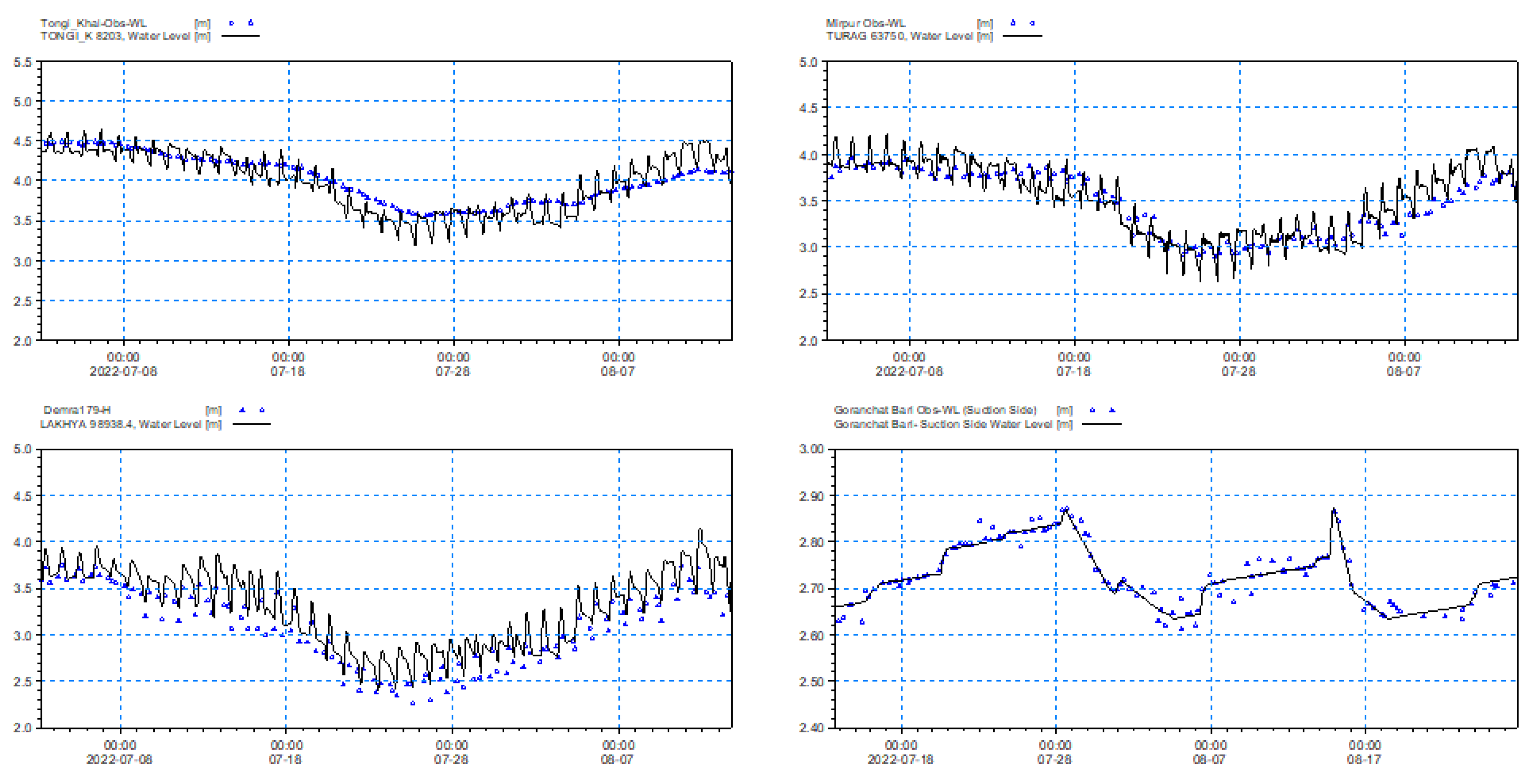
The Urban Flood Forecasting Model has been calibrated in two ways: one is consultation with local people and the other is verifying the past event with the model simulated data for extreme event 2019 and 2022 considering rainfall intensity. Another one is to compare between observed water level and model simulated water level for the year of 2019 for calibration and 2022 for validation. The list of comparison stations and model accuracy statistical parameters for calibration and validation are given in Table 2 and Table 3 respectively and these stations are shown in the Figure 13.
Figure 13.
Sub-catchment pipe distribution and calibration station in the model.
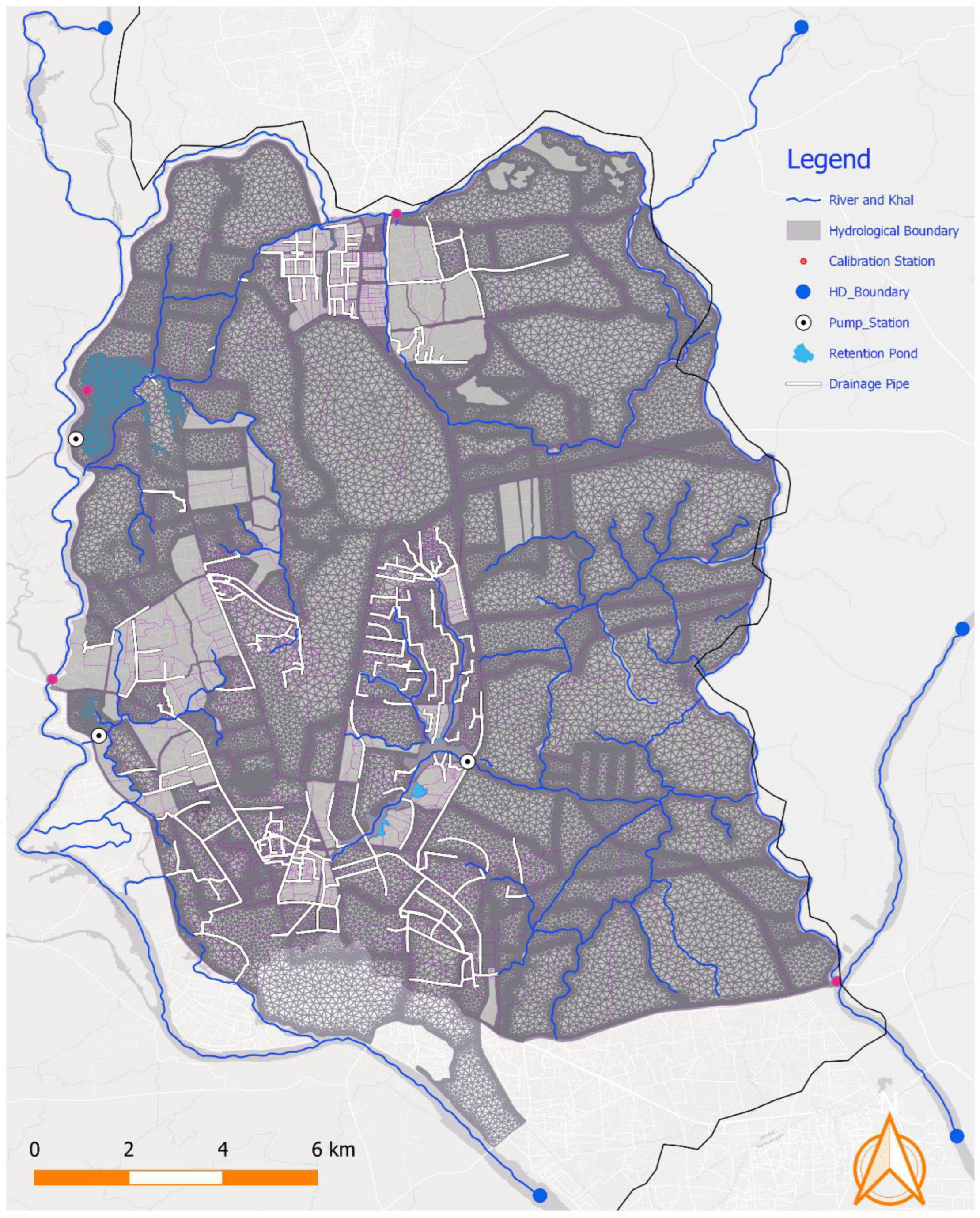
Figure 14.
Mike+ urban flood model calibration at different points within model doimain are shown in Figure 13. The blue line represents the observed water level, and the black represents the model simulation water level.
Figure 14.
Mike+ urban flood model calibration at different points within model doimain are shown in Figure 13. The blue line represents the observed water level, and the black represents the model simulation water level.
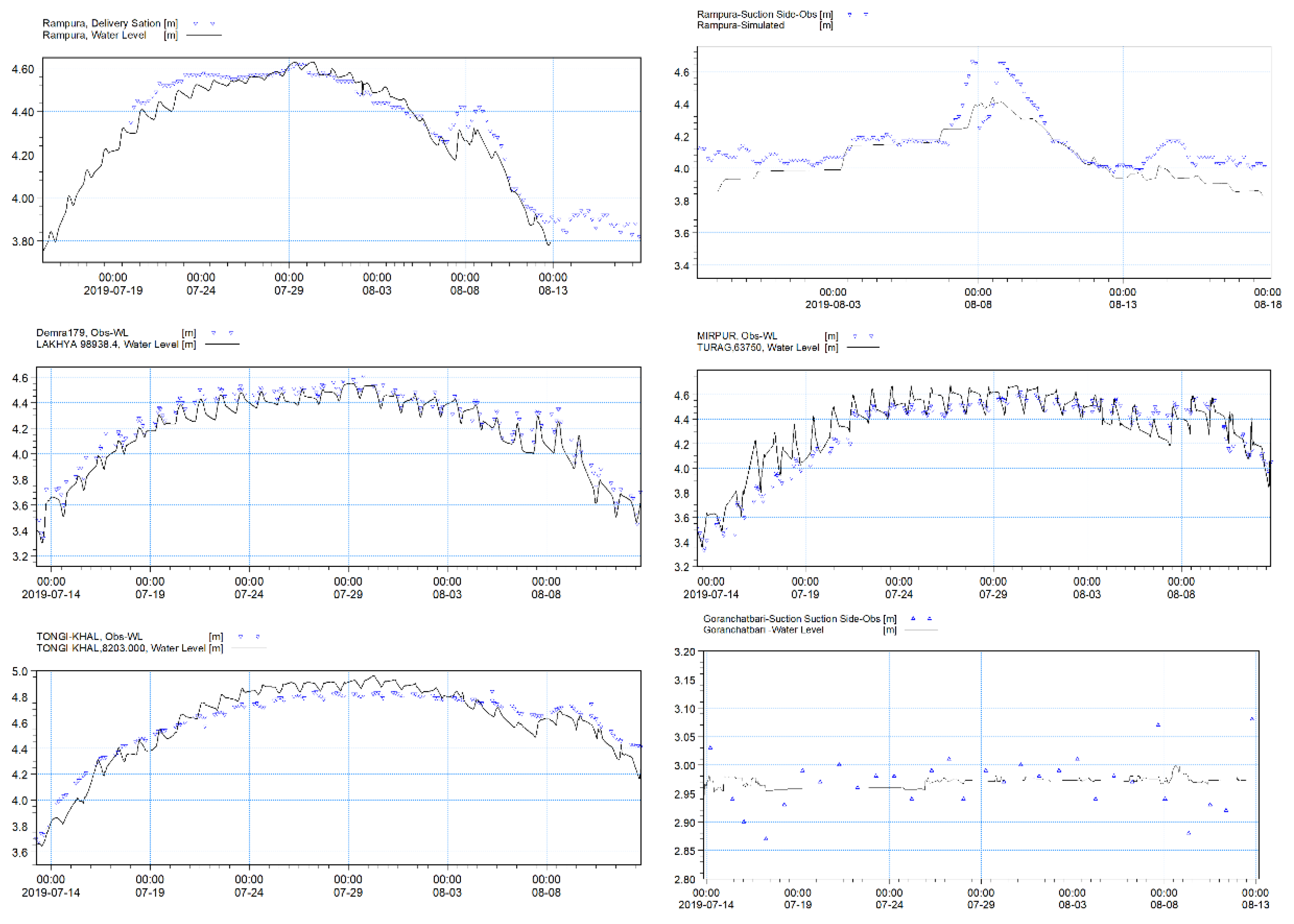
Figure 15.
Mike+ urban flood model validation at different points within model doimain are shown in Figure 13. The blue line represents the observed water level, and the black represents the model simulation water level.
Figure 15.
Mike+ urban flood model validation at different points within model doimain are shown in Figure 13. The blue line represents the observed water level, and the black represents the model simulation water level.
5. Forecast Products
This model is running based on the event regularly and produces the inundation map and road-specific bulletin. Results of two major events and field verification is given bellow. From the bulletin, it is observed that flood wasn’t captured by the model in a few places due to forecast rainfall and vertical accuracy of the terrain data. The Weather forecast resolution is 3km by 3km and only one observed rain gauge station is inside the Dhaka city that is unable to capture the rainfall variation over the whole Dhaka city. For this reason, some locations give false alarm.
Figure 16.
Flood inundation map on 24th October 2022, forecast made on 21st October 2022.
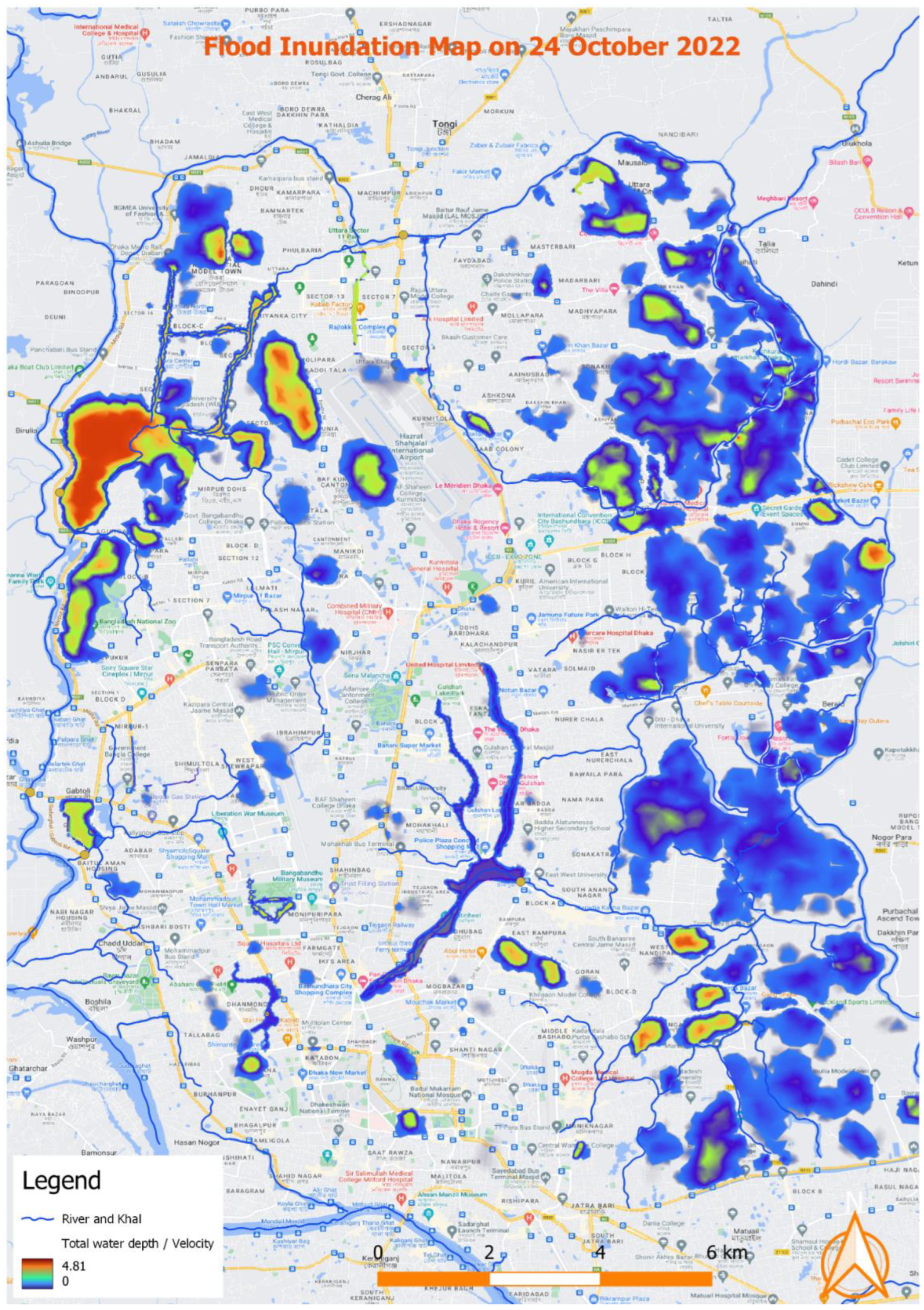
Figure 17.
Area specific inundation map on 24th October 2022, forecast made on 23rd October 2022.
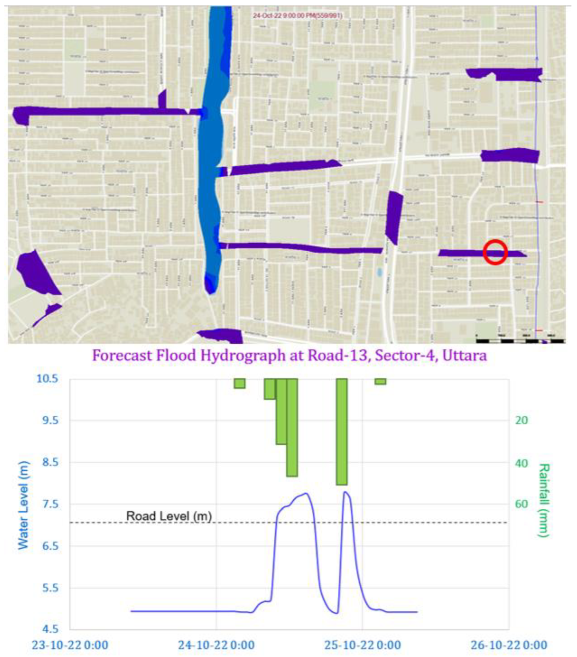

Table 4.
24 hours urban flood bulletin made on 23 October 2022.
| Area | Road | Importance location | 23-Oct-22 | 07-Jul-24 | ||
| WD (cm) | Alarm | WD (cm) | Alarm | |||
| Mirpur | Darus Salam Road | Govt Staff Quater | 30 | Hit | 27 | Hit |
| Mirpur | Darus Salam Road | Govt Bangla College | 5 | Hit | 3 | Hit |
| Mirpur | Darus Salam Road | BIHS Hospital | Miss | Miss | ||
| Mirpur | Dhaka Aricha Road | Mohona Filling Station | 5 | Hit | Miss | |
| Uttara | Shayestakhan Ave | Uttara Sector 02 | 67 | Hit | 54 | Hit |
| Uttara | Road 05 | Uttara Sector 04 | 33 | Hit | 23 | Hit |
| Uttara | Road 13 | Uttara Sector 4 | 4 | Hit | 3 | Miss |
| Kawla | Kawla RD | Kawla | 8 | Hit | 6 | Hit |
| Moghbazar | Moghbazar Road | PWD Staff Quater | 23 | Hit | 28 | Hit |
| Mohakhali | Mymensing Road | Mohakhali Bus Terminal | 45 | Hit | 50 | Hit |
| Mogbazar | Outer Circular Road | Moghbazar Convention Cent | Miss | 6 | Hit | |
| Mogbazar | Outer Circular Road | Dr Sirajul Islam Medical | 4 | Hit | 7 | Miss |
| Adabor | Road-13 | Uday Housing | 23 | Hit | 17 | Hit |
| Mirpur | Darus Salam Road | Govt Staff Quater | 30 | Hit | 25 | Hit |
*WD= Water Depth, Miss= Model couldn't capture the flood scenarios.
6. Discussion
This study utilized a limited dataset, including topographic information, observed water levels, and canal cross-sections. The 2D floodplain was updated using the latest available survey data, particularly focusing on road crest levels. The accuracy of the 2D model is highly dependent on the quality of the terrain data. Consequently, certain areas were not fully captured in the flood simulation, reflecting the limitations of the available topographic information.
Dhaka city currently has only one rainfall gauge station, which is insufficient to capture localized convective rainfall events. Additionally, the spatial resolution of the weather forecast, at 9 km, is inadequate for detecting small-scale convective events that frequently occur during the monsoon season. This limitation is critical in a city like Dhaka, where rainfall events are highly localized and vary significantly within short distances.
However, the model demonstrates greater accuracy in predicting widespread rainfall events, such as those caused by depressions or cyclonic activities, which tend to affect the entire city uniformly. To improve the accuracy of the model, particularly for localized rainfall events, it is essential to increase the number of rainfall gauge stations to at least ten across the city. Furthermore, higher-resolution weather forecast data, with grid sizes smaller than 1 km², would greatly enhance the model's ability to predict floods more precisely.
In addition to rainfall data, another significant challenge in Dhaka is the frequent blockage of the drainage and pipe network, which can exacerbate flooding. Implementing a regular or real-time monitoring system, potentially using cameras, could improve the performance of flood forecasting by identifying drainage issues in real-time and providing timely responses.
7. Conclusions
Dhaka, the capital city of Bangladesh, is highly vulnerable to urban flooding due to a combination of natural and human-made factors. Some causes of urban flooding in Dhaka are: Inadequate Drainage System, Rapid Urbanization, Encroachment of Water Bodies, Climate Change, High water level (mainly eastern part of Dhaka) of peripheral rivers etc. This flood can have a significant and long-lasting impact on the social, economic, and environmental well-being of the city and its residents. Therefore, it is essential to take proactive measures to mitigate the risk of urban floods and build resilient cities that can withstand extreme weather events. Urban Flood Forecasting Model has been developed under this study that can produce level and road specific 24-hours lead time forecast and minimize the urban flood-related risk and loss.
Author Contributions
Conceptualization, T.K.M., M.S.H. and N.S.; methodology, M.S.H., N.S. and T.K.M.; software, N.S., S.I, M.S.H. and L.C.M; validation, N.S. and M.S.H.; data analysis, N.S., S.I and L.C.M.; writing—original draft preparation, M.S.H., N.S and T.K.M; writing—review and editing, M.S.H., T.K.M., N.S., L.C.M and M.S.H; supervision, T.K.M., M.A.B. and S.U.R.; funding acquisition, T.K.M and M.A.B. All authors have read and agreed to the published version of the manuscript.
Funding
This study was funded by the Embassy of Denmark in Bangladesh under Ministry of Foreign Affairs (MFA), Denmark.
Data Availability Statement
The raw data supporting the conclusions of this article will be made available by the authors on request.
Acknowledgments
In this section, you can acknowledge any support given which is not covered by the author contribution or funding sections. This may include administrative and technical support, or donations in kind (e.g., materials used for experiments).
Conflicts of Interest
The authors declare no conflict of interest.
References
- E Trenberth, K. The Impact of Climate Change and Variability on Heavy Precipitation, Floods, and Droughts. In Encyclopedia of Hydrological Sciences; John Wiley & Sons, Ltd.: Hoboken, NJ, USA, 2006. [Google Scholar] [CrossRef]
- Eekhout, J.P.C.; Hunink, J.E.; Terink, W.; de Vente, J. Why increased extreme precipitation under climate change negatively affects water security. Hydrol. Earth Syst. Sci. 2018, 22, 5935–5946. [Google Scholar] [CrossRef]
- Tabari, H. Climate change impact on flood and extreme precipitation increases with water availability. Sci. Rep. 2020, 10, 1–10. [Google Scholar] [CrossRef] [PubMed]
- Willems, P.; Arnbjerg-Nielsen, K.; Olsson, J.; Nguyen, V. Climate change impact assessment on urban rainfall extremes and urban drainage: Methods and shortcomings. Atmospheric Res. 2012, 103, 106–118. [Google Scholar] [CrossRef]
- Pregnolato, M.; Ford, A.; Robson, C.; Glenis, V.; Barr, S.; Dawson, R. Assessing urban strategies for reducing the impacts of extreme weather on infrastructure networks. R. Soc. Open Sci. 2016, 3, 160023. [Google Scholar] [CrossRef] [PubMed]
- Rosenberg, E.A.; Keys, P.W.; Booth, D.B.; Hartley, D.; Burkey, J.; Steinemann, A.C.; Lettenmaier, D.P. Precipitation extremes and the impacts of climate change on stormwater infrastructure in Washington State. Clim. Chang. 2010, 102, 319–349. [Google Scholar] [CrossRef]
- Douglas, I. , Flooding in African cities, scales of causes, teleconnections, risks, vulnerability and impacts. International Journal of Disaster Risk Reduction, 2017. 26: p. 34-42.
- Hallegatte, S. , et al., Flood Risks, Climate Change Impacts and Adaptation Benefits in Mumbai. 2010.
- Koetse, M.J.; Rietveld, P. The impact of climate change and weather on transport: An overview of empirical findings. Transp. Res. Part D: Transp. Environ. 2009, 14, 205–221. [Google Scholar] [CrossRef]
- Jha, A.; Lamond, J.; Bloch, R.; Bhattacharya, N.; Lopez, A.; Papachristodoulou, N.; Bird, A.; Proverbs, D.; Davies, J.; Barker, R. Five Feet High and Rising: Cities and Flooding in the 21st Century; World Bank: Washington, DC, United States, 2011. [Google Scholar]
- Hossain, A.A. and G. Easson, Potential Impacts of the Growth of a Megacity in Southeast Asia: A Case Study on the City of Dhaka, Bangladesh, in Handbook of Climate Change Mitigation and Adaptation. 2022, Springer. p. 2731-2758.
- Dasgupta, S.; Zaman, A.; Roy, S.; Huq, M.; Jahan, S.; Nishat, A. Urban Flooding of Greater Dhaka in a Changing Climate: Building Local Resilience to Disaster Risk; World Bank: Washington, DC, United States, 2015. [Google Scholar]
- Ahmed, S.; Meenar, M.; Alam, A. Designing a Blue-Green Infrastructure (BGI) Network: Toward Water-Sensitive Urban Growth Planning in Dhaka, Bangladesh. Land 2019, 8, 138. [Google Scholar] [CrossRef]
- Khaleda, S., Q. A. Mowla, and Y. Murayama, Dhaka metropolitan area. Urban Development in Asia and Africa: Geospatial Analysis of Metropolises, 2017: p. 195-215.
- Gain, A.K.; Mojtahed, V.; Biscaro, C.; Balbi, S.; Giupponi, C. An integrated approach of flood risk assessment in the eastern part of Dhaka City. Nat. Hazards 2015, 79, 1499–1530. [Google Scholar] [CrossRef]
- Siddiqua, A. , Development of integrated landscape framework at land-water interface for water sensitive urban design in the eastern fringe of Dhaka metropolitan area. 2021.
- Fatemi, M.N. , A study on physical vulnerability to flooding in residential areas and coping strategies of local community in Eastern Dhaka, Bangladesh. 2020.
- Abdullah, M.S. , et al., Urbanising Delta: What Lessons Dhaka Offers to Face Challenges. J. Pol'y & Gov. 2021, 1, 1. [Google Scholar]
- Halder, A.; Majed, N. The effects of unplanned land use and heavy seasonal rainfall on the storm-water drainage in Dhaka metropolitan city of Bangladesh. Urban Water J. 2023, 20, 707–722. [Google Scholar] [CrossRef]
- Rahman, R. and M. Salehin, Flood risks and reduction approaches in Bangladesh. Disaster risk reduction approaches in Bangladesh, 2013: p. 65-90.
- Baker, J.L. , Climate change, disaster risk, and the urban poor: cities building resilience for a changing world. 2012: World Bank Publications.
- Afjal Hossain, M. , et al., Climate change and its impacts on the livelihoods of the vulnerable people in the southwestern coastal zone in Bangladesh. Climate change and the sustainable use of water resources, 2012: p. 237-259.
- Bakhtiari, V.; Piadeh, F.; Chen, A.S.; Behzadian, K. Stakeholder analysis in the application of cutting-edge digital visualisation technologies for urban flood risk management: A critical review. Expert Syst. Appl. 2024, 236. [Google Scholar] [CrossRef]
- Aljohani, F.H. , et al., Flood Prediction using Hydrologic and ML-based Modeling: A Systematic Review. International Journal of Advanced Computer Science & Applications, 2023. 14(11). [CrossRef]
- Acosta-Coll, M.; Ballester-Merelo, F.; Martinez-Peiró, M.; De la Hoz-Franco, E. Real-Time Early Warning System Design for Pluvial Flash Floods—A Review. Sensors 2018, 18, 2255. [Google Scholar] [CrossRef] [PubMed]
- Bouramdane, A.-A. Enhancing disaster management in smart cities through MCDM-AHP analysis amid 21st century challenges. Inf. Syst. Smart City 2023, 3. [Google Scholar] [CrossRef]
- Ceenepalli, P. and C. Chandrasekhar. IoT-Enabled Flood Wall: Advancing Real-Time Flash Flood Monitoring and Forecasting. in 2023 International Conference on Self Sustainable Artificial Intelligence Systems (ICSSAS). 2023. IEEE.
- Taubenböck, H.; Esch, T.; Felbier, A.; Wiesner, M.; Roth, A.; Dech, S. Monitoring urbanization in mega cities from space. Remote. Sens. Environ. 2011, 117, 162–176. [Google Scholar] [CrossRef]
- Kabir, M.H. , et al., Assessment of urban disaster resilience in Dhaka North City Corporation (DNCC), Bangladesh. Procedia Eng. 2018, 212, 1107–1114. [Google Scholar] [CrossRef]
- Rahman, S. , Households' flood vulnerability assessment in context of climate change. 2011, University of Twente.
- Tawhid, K.G. , Causes and effects of water logging in Dhaka City, Bangladesh. TRITA-LWR master thesis, Department of Land and Water Resource Engineering, Royal Institute of Technology, Stockholm, 2004.
- Dewan, A.M.; Islam, M.M.; Kumamoto, T.; Nishigaki, M. Evaluating Flood Hazard for Land-Use Planning in Greater Dhaka of Bangladesh Using Remote Sensing and GIS Techniques. Water Resour. Manag. 2006, 21, 1601–1612. [Google Scholar] [CrossRef]
- Rahman, K.N. , et al., Water in Cities: CAN WE END THE WAR?: Experiences from the Detailed Area Plan of Dhaka, in Handbook of Waterfront Cities and Urbanism. 2022, Routledge. p. 222-238.
- Alam, S., S. Jahan, and F. Noor, The surface water system, flood and water resources management of Bangladesh. Bangladesh Geosciences and Resources Potential, 2022: p. 467-546.
- Islam, S. and S. Miah, Banglapedia: national encyclopedia of Bangladesh. (No Title), 2003.
- Shahid, S.; Wang, X.-J.; Bin Harun, S.; Shamsudin, S.B.; Ismail, T.; Minhans, A. Climate variability and changes in the major cities of Bangladesh: observations, possible impacts and adaptation. Reg. Environ. Chang. 2015, 16, 459–471. [Google Scholar] [CrossRef]
- Alam, M. and M.G. Rabbani, Vulnerabilities and responses to climate change for Dhaka, in Adapting Cities to Climate Change. 2012, Routledge. p. 112-129.
- Rahman, A.A. , et al., Risks, vulnerability and adaptation in Bangladesh. Human Development Report, 2007. 8.
- Timbadiya, P., P. Patel, and P. Porey, One-dimensional hydrodynamic modelling of flooding and stage hydrographs in the lower Tapi River in India. Current science, 2014: p. 708-716.
- Mishra, R. , Dam Breach Parameters and its Effects on Propagation of Flood Wave at the Downstream of Sarabgarh Irrigation Project. 2018.
- Akhter, S. , et al., Simulation of High Impact Monsoon Rainfall and its Thermodynamic Features over Bangladesh Using WRF Model.
- moni Boruah, M.T. , Development of 1d and 2d Hydrodynamic Flood Model Using Mike Software by Dhi”. 2017.
- Balmforth, D. , Designing for exceedance in urban drainage: good practice. 2006: London: CIRIA.
- DHI, D.W.E. , MIKE 21 & MIKE 3 Flow Model FM. 2023.
- Liu, J. , et al. , Urban flood modelling in Qiqihar city based on MIKE flood. Proceedings of the International Assoc. Hydrol. Sci. 2020, 383, 185–192. [Google Scholar]
- Novak, P. , et al., Hydraulic structures. 2017: CRC Press.
- Liu, J.; Cai, J.; Yang, D.; Wang, X. A numerical visualization technique based on the hydraulic analogy. J. Vis. 2018, 22, 371–384. [Google Scholar] [CrossRef]
- Song, Y.; Huang, J.; Toorman, E.; Yang, G. Reconstruction of River Topography for 3D Hydrodynamic Modelling Using Surveyed Cross-Sections: An Improved Algorithm. Water 2020, 12, 3539. [Google Scholar] [CrossRef]
- MIKE, MIKE 21 & MIKE 3 Flow Model FM.
- Metcalf, et al., Wastewater engineering: treatment and resource recovery. 2014: McGraw Hill Education.
- Sultana, T. and T.K. Magumdar, Consultancy Services for Expansion flood forecasting model (whole country) Improve inundation model in coastal and hotspot areas (depth and area of inundation). 2024, Institute of Water Modelling (IWM): Dhaka.
Figure 1.
Location and administrative map of Dhaka city [35].
Figure 1.
Location and administrative map of Dhaka city [35].
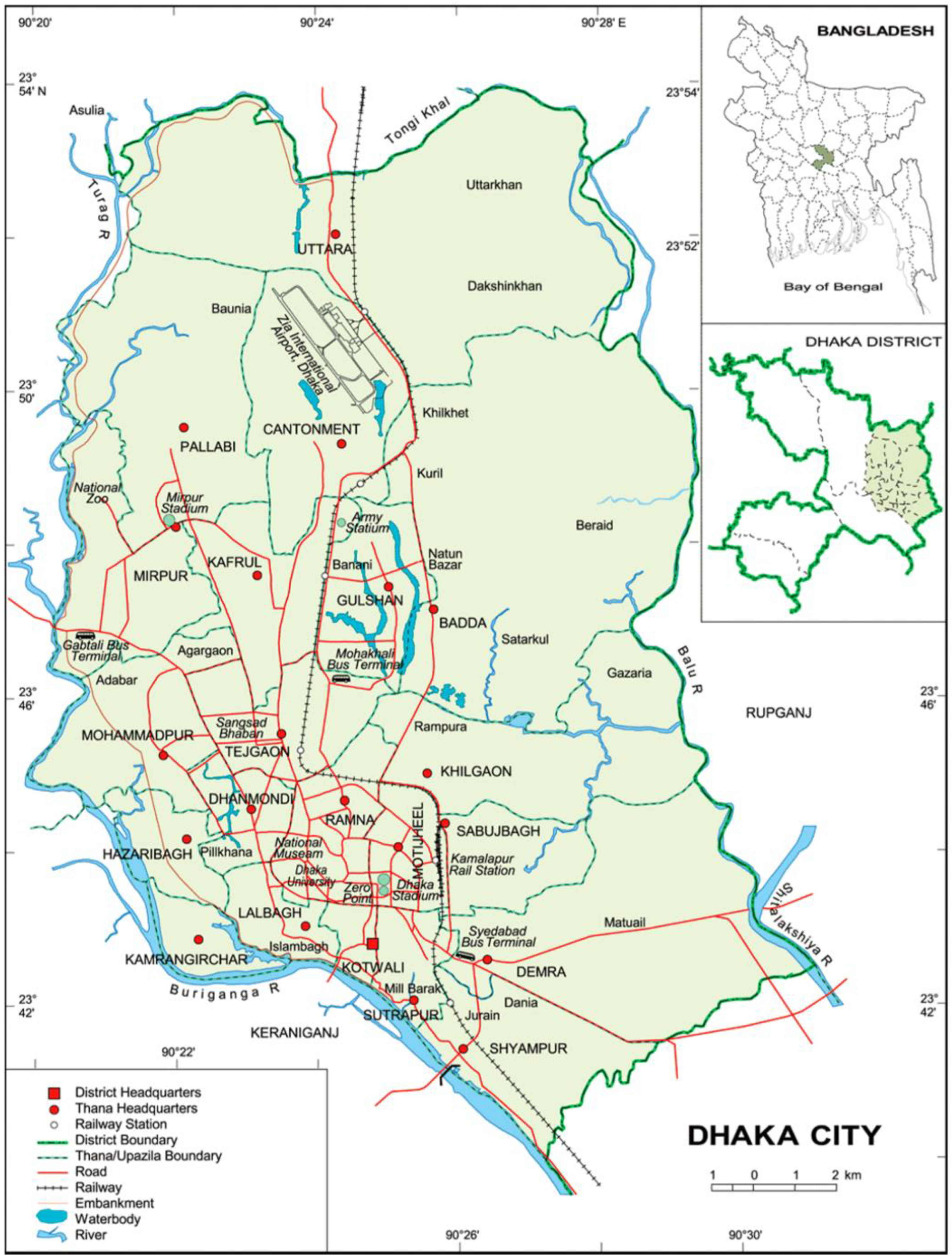
Figure 2.
Monthly average rainfall in Dhaka City.
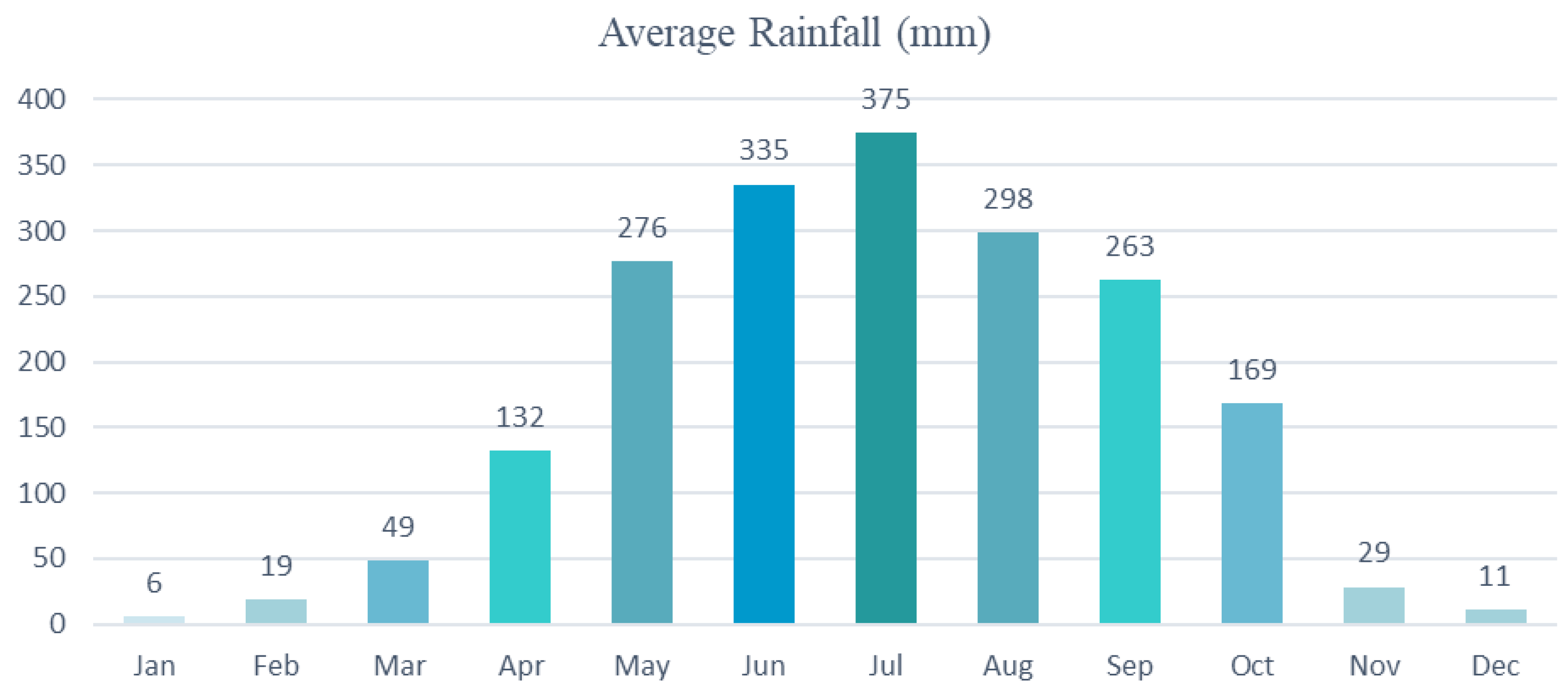
Figure 3.
Methodology for development of Urban Flood Forecasting System (RMSE = root mean square error, WRF= Weather Forecasting and Research and ECMWF = European Centre for Medium-Range Weather Forecasts).
Figure 3.
Methodology for development of Urban Flood Forecasting System (RMSE = root mean square error, WRF= Weather Forecasting and Research and ECMWF = European Centre for Medium-Range Weather Forecasts).
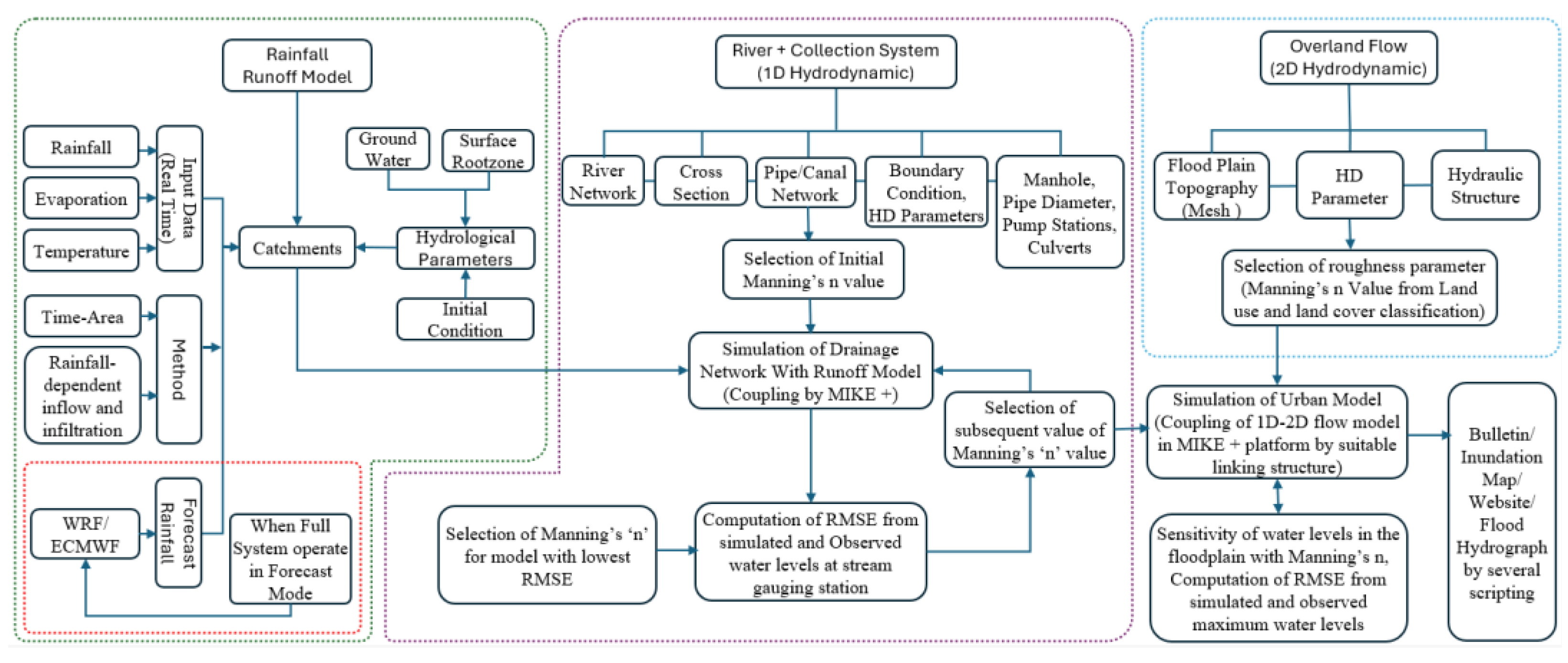
Figure 4.
Spot level and road level survey for updating exiting DEM data for floodplain modelling.
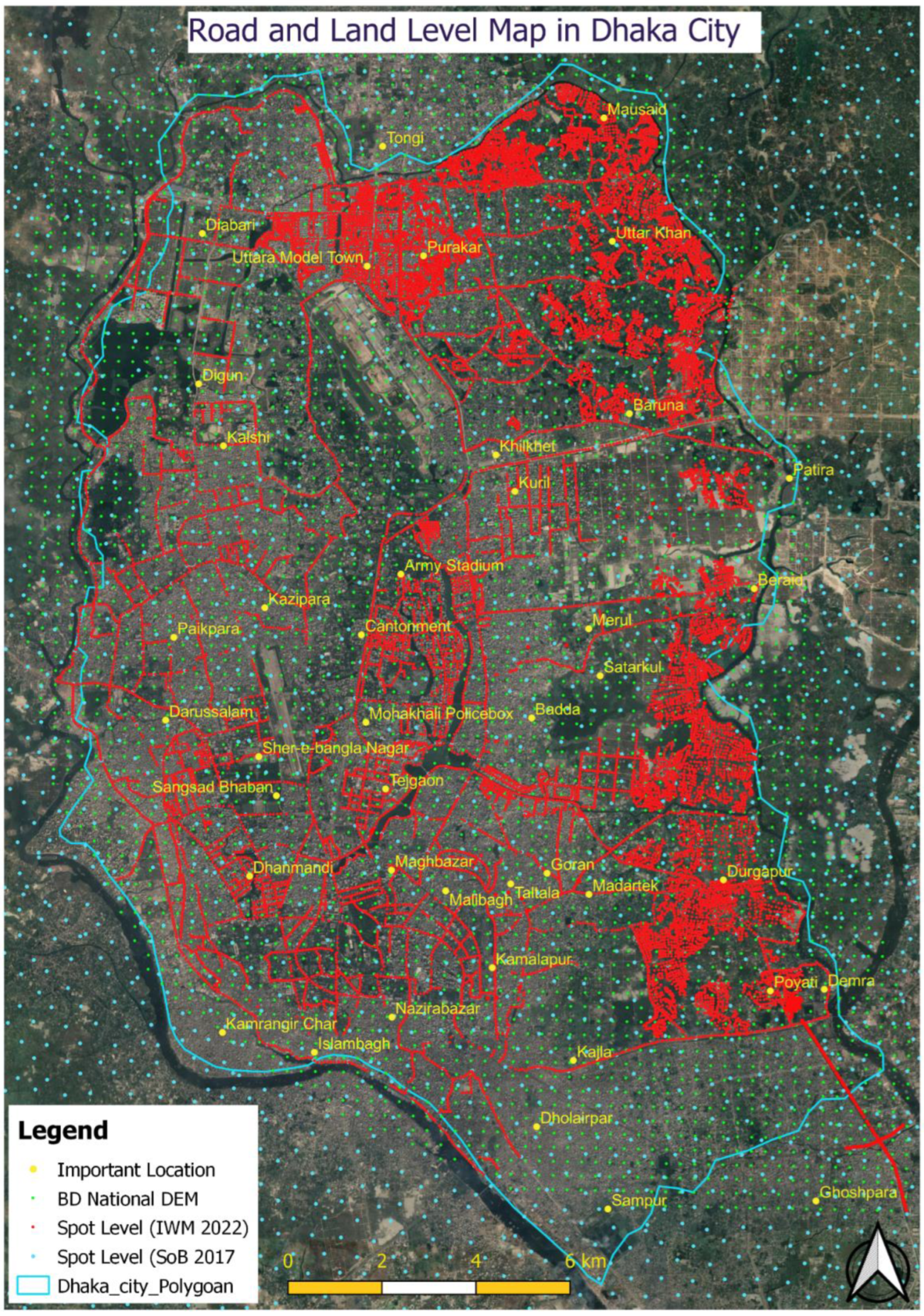
Figure 5.
Pipe network, pump station, manhole, river network, retention pond, catchment distribution and model boundary in the model setup.
Figure 5.
Pipe network, pump station, manhole, river network, retention pond, catchment distribution and model boundary in the model setup.
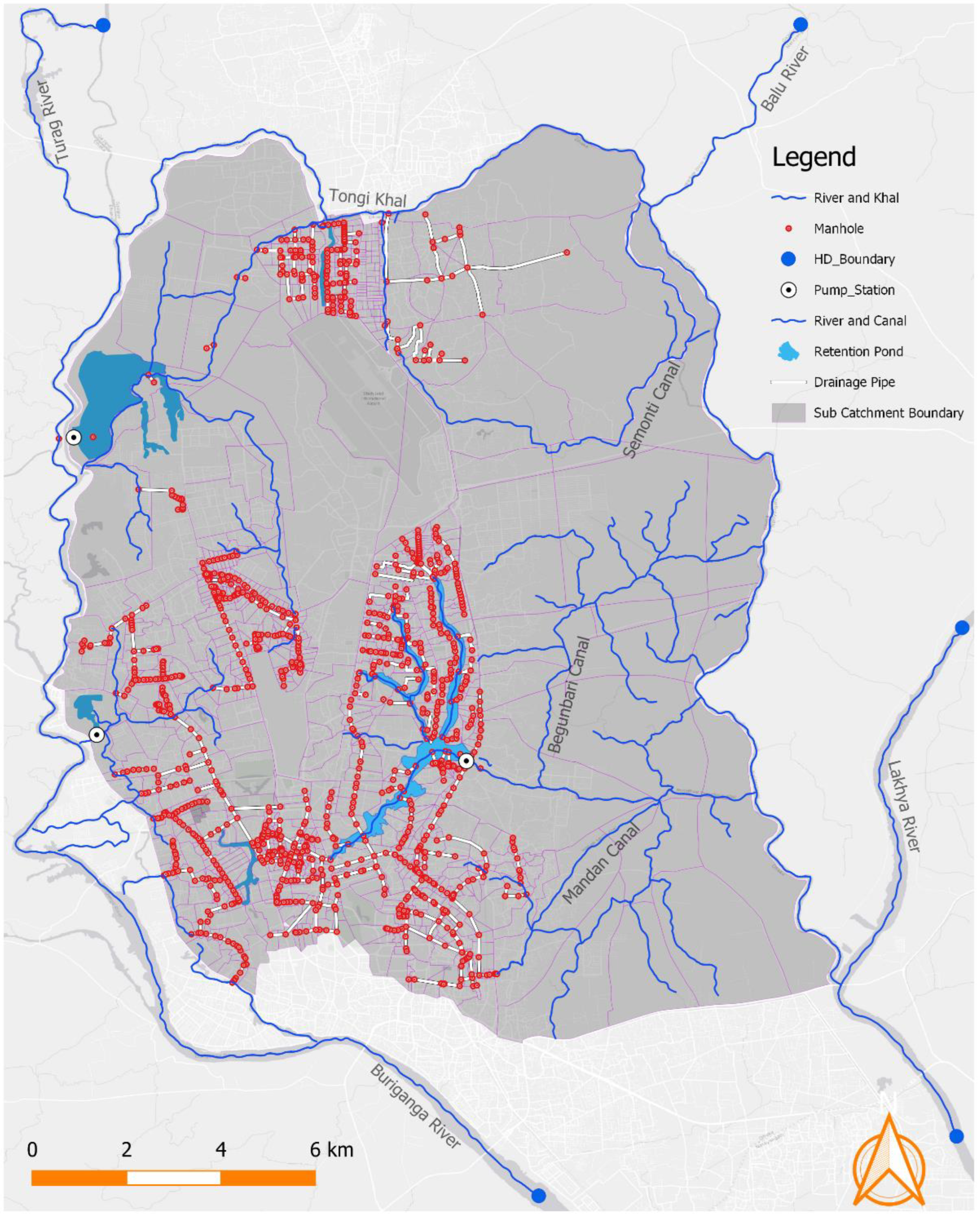
Figure 6.
24 hours rainfall forecast on 23 October 2022 by BMD that is used in the model.
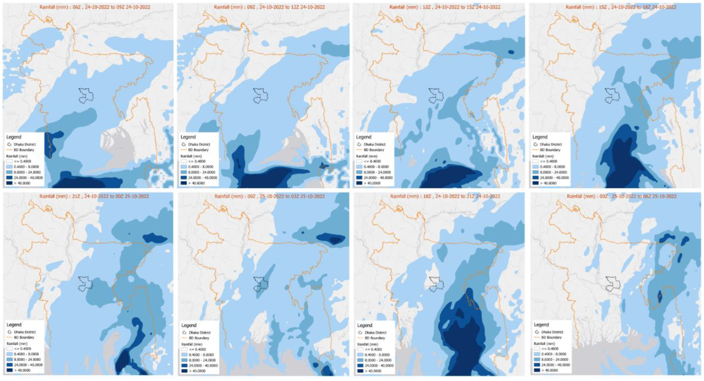
Figure 7.
Zone wise drainage system, Sluice gate, Embankment and Road Network.
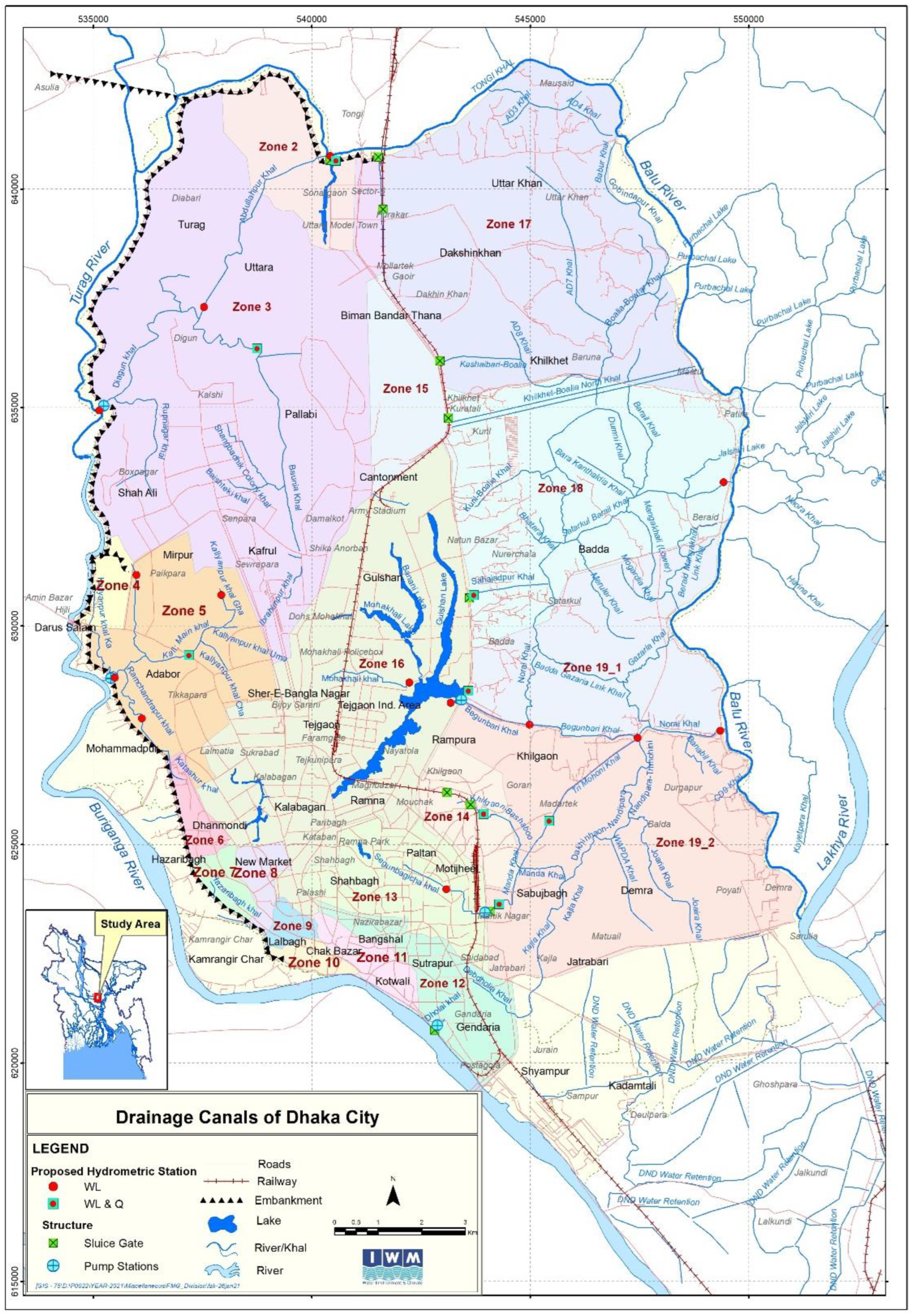
Figure 8.
Crest level of Dhaka Integrated Flood Control embankment.
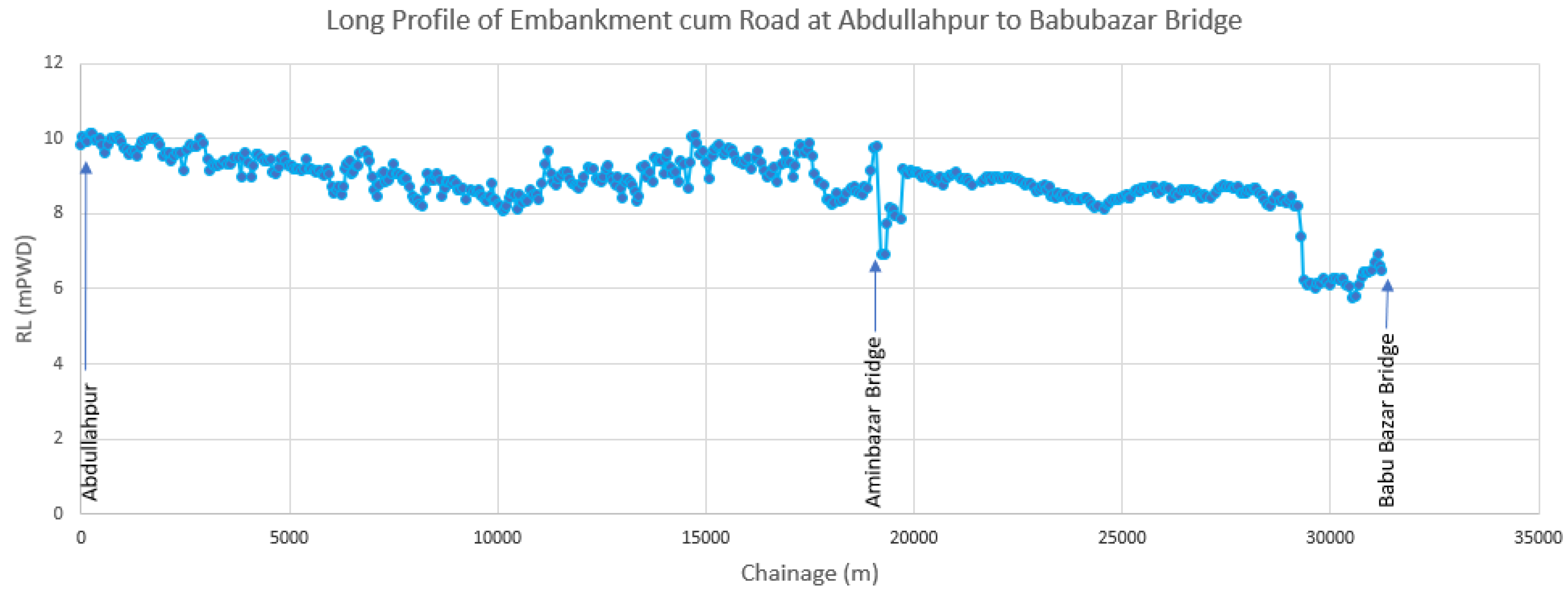
Figure 9.
Conceptual representation of urban flood [43].
Figure 9.
Conceptual representation of urban flood [43].
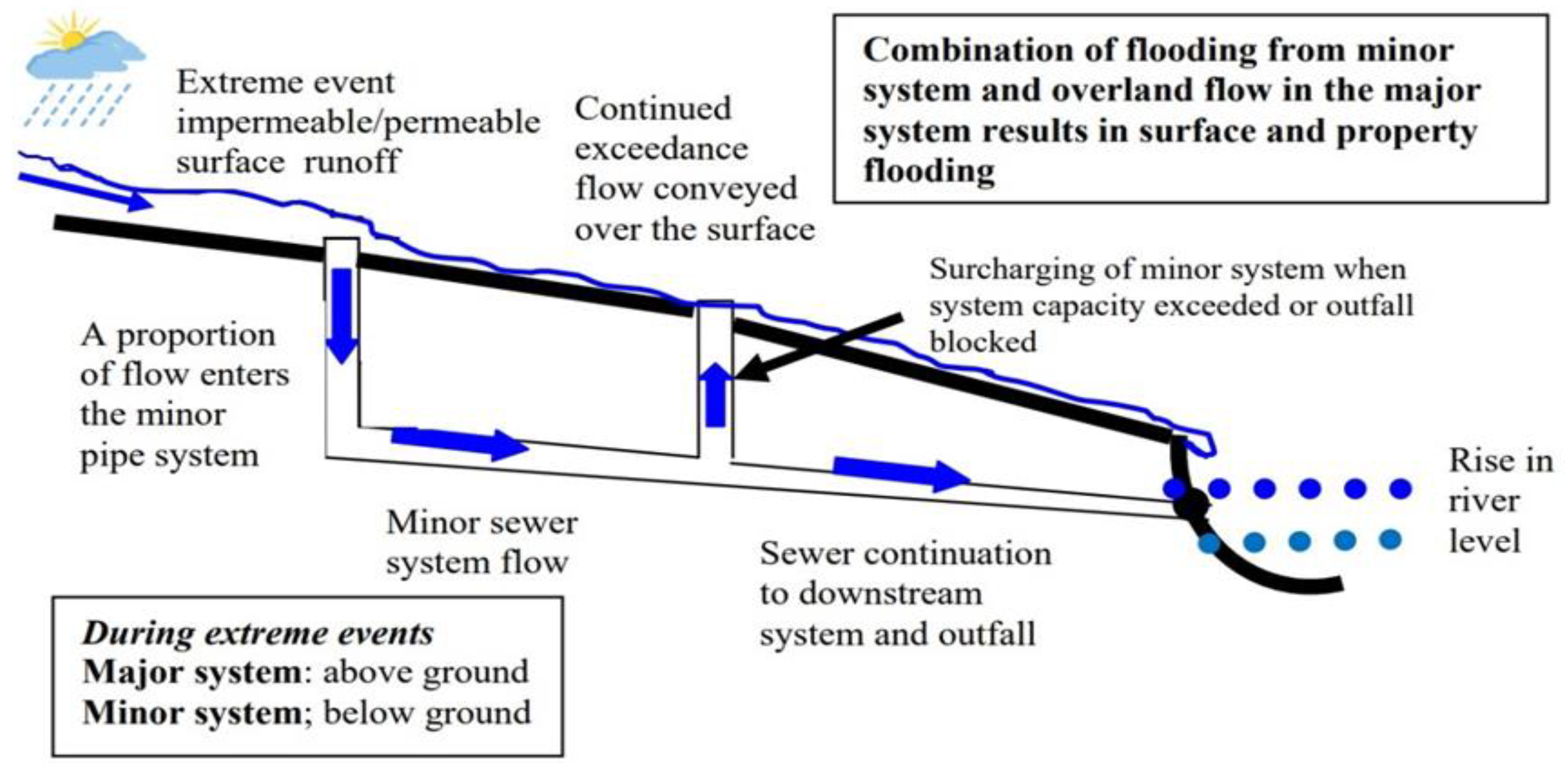
Figure 10.
Concept of Time Area Model to compute surface runoff.
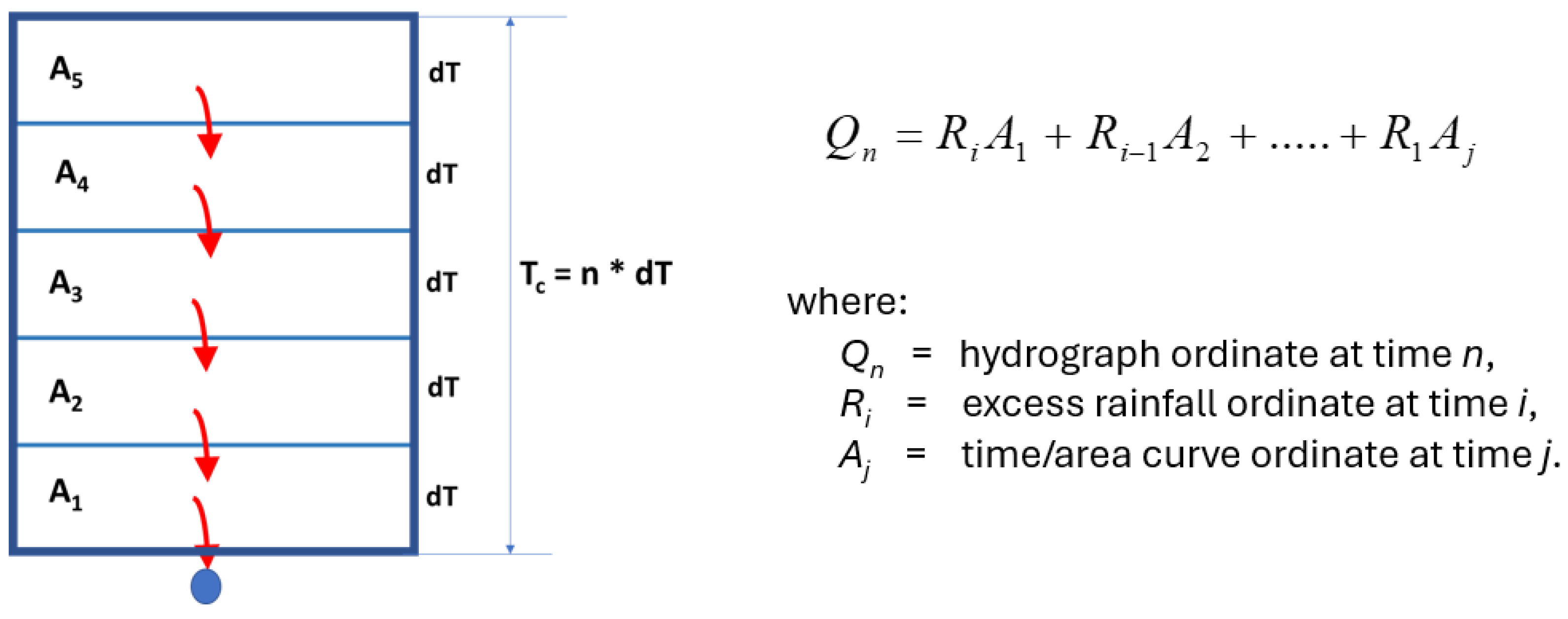
Figure 11.
A) The computational grid, B) The computational grid in network, C) Structure location, D) Loss, flow in and out and E) Water flowing through the node in 1D pipe network [44].
Figure 11.
A) The computational grid, B) The computational grid in network, C) Structure location, D) Loss, flow in and out and E) Water flowing through the node in 1D pipe network [44].
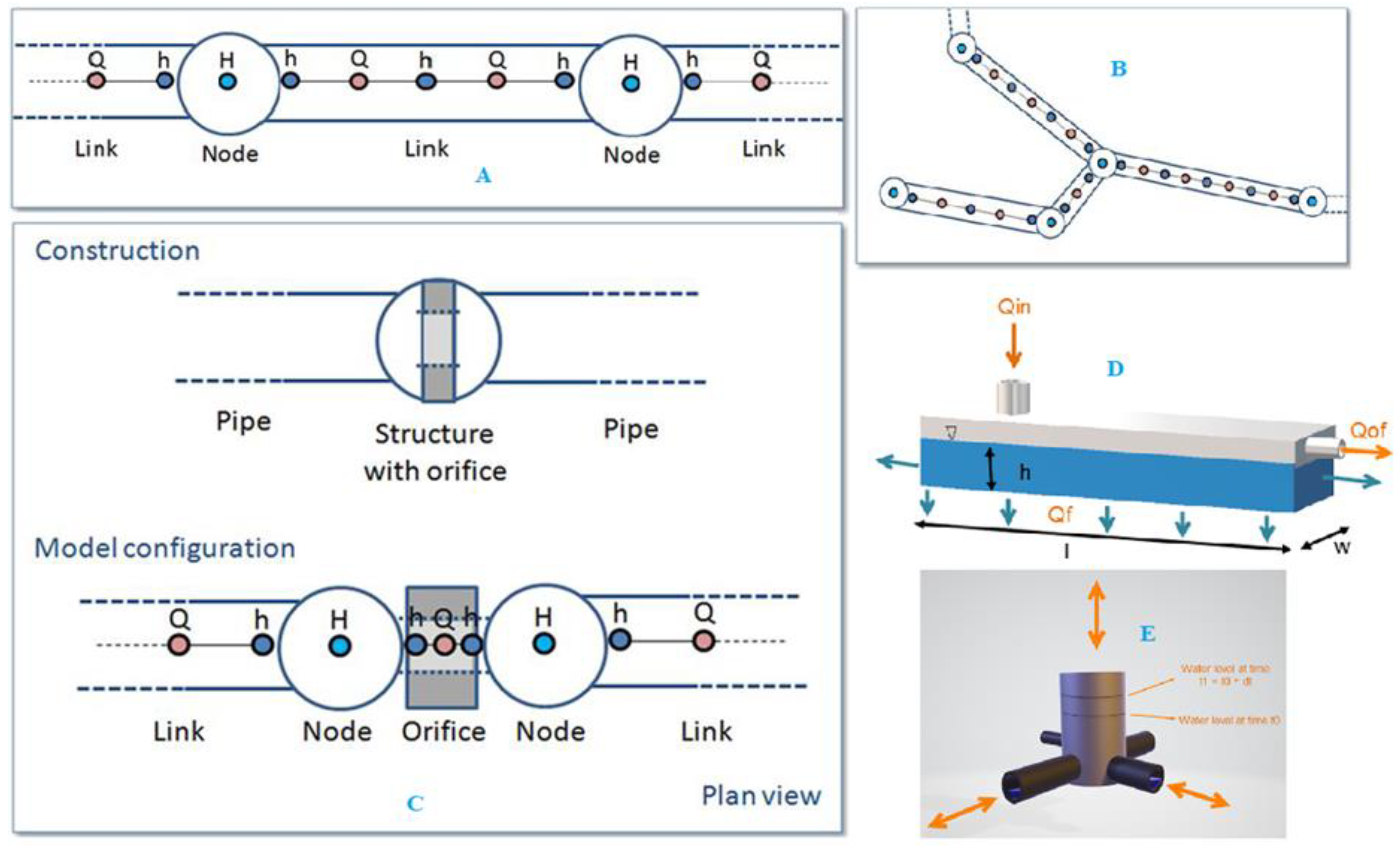
Figure 12.
1D hydrodynamic collection coupled with 2D hydrodynamic model. Different types coupling like lateral, standard, manhole are made with floodplain.
Figure 12.
1D hydrodynamic collection coupled with 2D hydrodynamic model. Different types coupling like lateral, standard, manhole are made with floodplain.
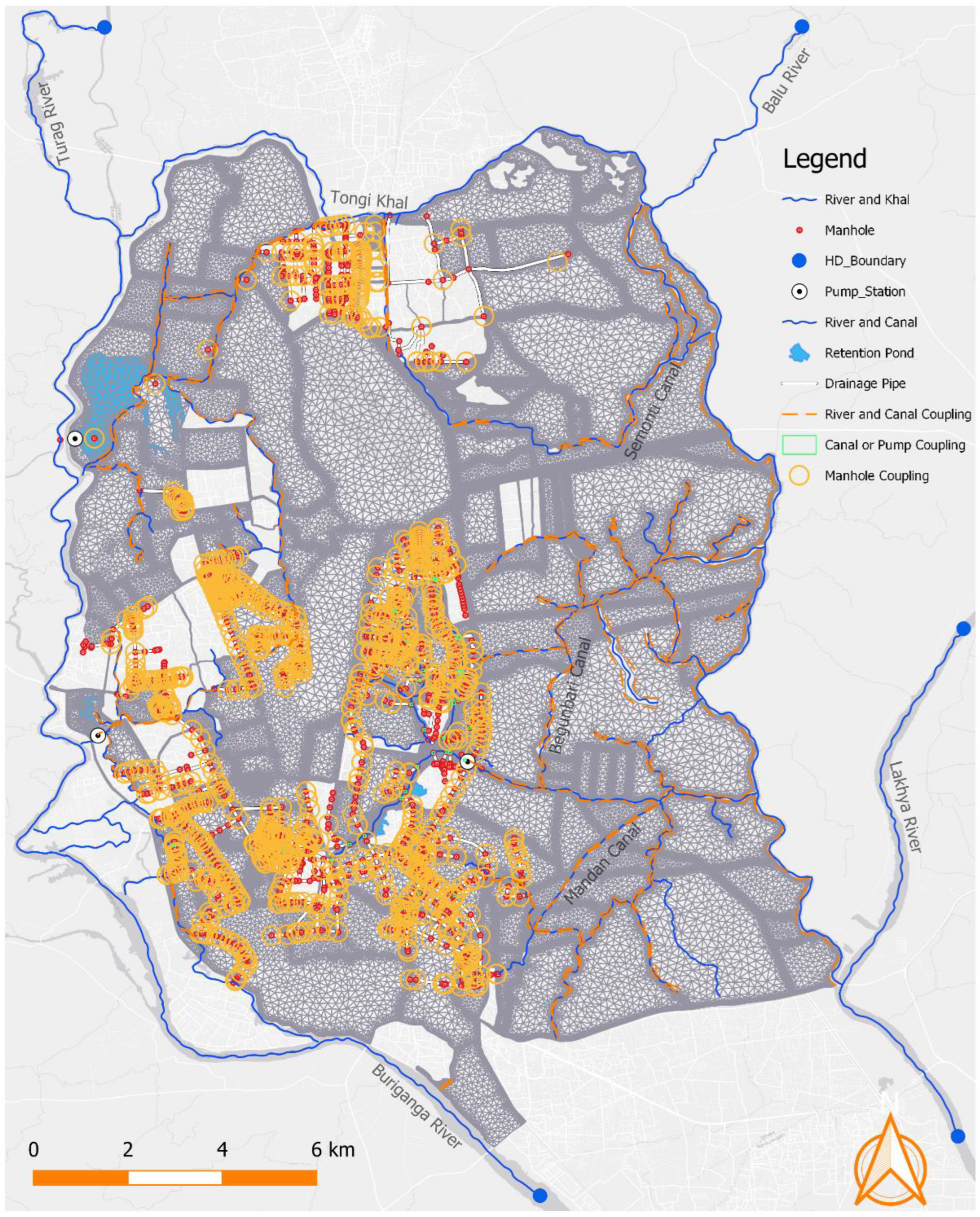
Table 1.
Cross-section list in different khals and rivers from secondary sources.
| Sl | Name Of Khal | Length (M) | No Of X-Section | Remarks |
| 1 | Balu River | 3150 | 11 | IWM-2018 |
| 2 | Buriganga | 17000 | 7 | IWM-2016 |
| 3 | Gulshan Lake | 3985 | 7 | IWM-2017 |
| 4 | Joaira_Khal | 4000 | 10 | IWM-2018 |
| 5 | Khilgaon-Basabo_Khal | 3000 | 15 | DWASA-2007 |
| 6 | Lakhya | 4500 | 19 | BWDB-2001 |
| 7 | Lakhya | 25000 | 37 | IWM-2018 |
| 8 | Senotikhal | 5650 | 9 | IWM-2016 |
| 9 | Tongi Khal | 16200 | 11 | IWM-2018 |
| 10 | Turag | XX | 30 | IWM-2018 |
| 11 | Wapda_Khal | 2360 | 13 | IWM-2016 |
| 12 | Canal | 120254 | 174 | IWM-2022 |
Table 2.
Results of efficiency indexes for calibration (year 2019).
| Indices | Unit | Rampura (Suction Side) |
Rampura (Delivery Side) |
Demra | Mirpur | Tongi | Goranchat Bari (Suction Side) |
| ME | [m] | 0.09 | 0.04 | -0.03 | -0.05 | -0.04 | 0.00 |
| MAE | [m] | 0.10 | 0.06 | 0.05 | 0.10 | 0.09 | 0.04 |
| R^2 | [-] | 0.69 | 0.97 | 0.96 | 0.84 | 0.92 | 0.07 |
| NSE | [-] | 0.79 | 0.93 | 0.94 | 0.81 | 0.73 | 0.85 |
| IA | [-] | 0.83 | 0.98 | 0.99 | 0.94 | 0.95 | 0.21 |
*Abbreviations: ME = Mean Error, MAE = Mean Absolute Error, RMSE = Root Mean Square Error, R2 = Coefficient of Determination, NSE = Coefficient of Efficiency, IA = Index of Agreement.
Table 3.
Results of efficiency indexes for Validation (year 2022).
| Indices | Unit | Rampura (Suction Side) |
Rampura (Delivery Side) |
Demra | Mirpur | Tongi | Goranchat Bari (Suction Side) |
| ME | [m] | 0.07 | 0.08 | -0.05 | -0.03 | -0.04 | 0.00 |
| MAE | [m] | 0.o9 | 0.07 | 0.07 | 0.09 | 0.10 | 0.05 |
| R^2 | [-] | 0.66 | 0.97 | 0.93 | 0.84 | 0.92 | 0.75 |
| NSE | [-] | 0.63 | 0.93 | 0.92 | 0.81 | 0.73 | 0.78 |
| IA | [-] | 0.81 | 0.98 | 0.91 | 0.94 | 0.95 | 0.21 |
Abbreviations: ME = Mean Error, MAE = Mean Absolute Error, RMSE = Root Mean Square Error, R2 = Coefficient of Determination, NSE = Coefficient of Efficiency, IA = Index of Agreement.
Disclaimer/Publisher’s Note: The statements, opinions and data contained in all publications are solely those of the individual author(s) and contributor(s) and not of MDPI and/or the editor(s). MDPI and/or the editor(s) disclaim responsibility for any injury to people or property resulting from any ideas, methods, instructions or products referred to in the content. |
© 2024 by the authors. Licensee MDPI, Basel, Switzerland. This article is an open access article distributed under the terms and conditions of the Creative Commons Attribution (CC BY) license (https://creativecommons.org/licenses/by/4.0/).
Copyright: This open access article is published under a Creative Commons CC BY 4.0 license, which permit the free download, distribution, and reuse, provided that the author and preprint are cited in any reuse.


