Submitted:
19 August 2024
Posted:
21 August 2024
You are already at the latest version
Abstract
Based on the land use data of Qingmei Harbor Mangrove Nature Reserve in Sanya, China, in 2009, 2015 and 2022, this paper utilizes the PLUS model to predict the land use changes in the region in 2035 under three development scenarios, namely natural development, urban construction and ecological protection. The results of the study show that the area of building land in this region increased rapidly from 2009-2015, and the corresponding cropland, parkland and arbor forest land as a whole showed a different degree of decline, while the expansion of the area of manmade land, such as building land, basically came to a standstill after 2015. However, the mangrove area in this region has maintained a stable growth trend from 2009-2022. The results of multi-scenario modeling of land in this region showed that the area of building land, unutilized land, and artificial land such as parkland and grassland increased the most under the urban development scenario. In the ecological protection scenario, the area of ecological land, such as arbor forest land and river and lagoon, increases significantly. However, there is no significant increase in the area of mangrove forests under any of the three development scenarios. At present, the task of “returning ponds to wetlands” has been basically completed in this area, and the space for large-scale expansion of mangrove forests in Qingmei Harbor is limited in the future, and the focus of subsequent work should be shifted to the enhancement of the quality and function of mangrove ecosystems.
Keywords:
mangrove forest
; Qingmei Harbor
; PLUS model
; land use change
Introduction
Mangrove forests in Sanya are the most tropical mangrove resources in China, characterized by the richest variety of mangrove plants and the largest number of rare and endangered species [1], which possesses a very high value for development and utilization and protection [2]. Sanya historically had more than 2000hm2 of mangrove growth [3], in the middle and late last century, due to artificial logging, pond farming, development and construction of coastal zones and other factors, the mangrove area of Sanya City has shrunk significantly[4], and only a small area of mangrove forests remains in Qingmei Harbor, Tielu Harbor, Sanya River, and Yulin Harbor, etc., and the mangrove resources of Sanya are in danger. After 2000, with China's all-round efforts to increase the protection of mangrove forests [5,6], as well as the implementation of special actions for the protection and restoration of mangrove forests in Hainan, mangrove wetland protection and restoration have achieved obvious results [7], gradually reversing the situation of the shrinking area of mangrove wetlands, and the area of mangrove forests has realized a steady growth.
Nevertheless, Sanya coastal areas of mangrove resources protection situation is still serious [8], especially in recent years with the construction of Hainan Free Trade Port, Hainan ushered in a new round of development boom, accelerating the process of urbanization of the coastal areas, Sanya coastal land demand has become larger, resource and environmental contradictions aggravated, to the protection of mangrove wetlands has brought great challenges. Therefore, this study utilizes the PLUS model (Patch-generating Land Use Simulation) to simulate the land use change process and predict the future land use dynamics. From the perspective of land use types and evolutionary patterns, the potential of mangrove land resource utilization can be explored, which can better provide a scientific basis for regional mangrove protection and restoration, and help local economic and ecological development.
1. Study Area and Data Sources
1.1. Description of the Study Area
Qingmei Harbor Mangrove Nature Reserve is located in Yalong Bay National Tourist Resort (108°36'24 "E, 18°12'44 "N), with an area of 155 hectares, which belongs to the lagoon and harbor type wetland conservation area, with the largest continuous area and the most complete community succession of mangrove wetland in Sanya, which has high ecological value and scientific research value. Fifteen species of true mangrove plants and seven species of semi-mangrove plants have been found in the area, with Lumnitzera racemosa Willd., Ceriops tagal (Perr.) C. B. Rob., and Rhizophora apiculata Bl. as the dominant species [9,10]. Since the late 1990s, with the establishment of the Yalong Bay National Tourism Resort, a large number of hotels and related tourism and other facilities have been built around the protected area, and the development and construction of the surrounding land has put pressure on the mangrove ecosystem, threatening the protection and development of mangrove wetlands, and the contradiction in land use has become increasingly prominent. This study takes Qingmei Harbor Mangrove Reserve as the core, and appropriately expands to the periphery according to the scope of village and town administrative division, the specific scope is shown in Figure 1.
1.2. Data Source and Processing
The research institute used three periods of Chinese land use raster data in 2009, 2015 and 2022 from Google Earth Engine remote sensing cloud platform, based on human-computer interaction interpretation, combined with the field survey, interpreted and mapped the distribution of mangrove forests and the surrounding land use types. Land use types are categorized into 11 types based on the actual situation of the survey area and its relationship with the distribution area of mangrove wetlands, such as cropland, parkland, aquaculture pond, pit pond, river and lagoon, building land, unutilized land, grassland, mangrove land, transportation land and arbor forest land, etc. (Figure 2).
2. Research Methods
2.1. Land Use Transfer Matrix
Using a land transfer matrix, the direction and number of conversions for 11 land types from 2009-2022 were analyzed to quantitatively show data on conversions between different landscape types of land [5 ZHOU Wei1,2, LI Haoran1, HUANG Lu1, YUAN Yiyuan1, XIE Yuhao1. Evolution of Urban Green Space and Its Carbon Sequestration Benefit in Nanan District of Chongqing[J]. Journal of Chongqing Jiaotong University (Natural Science), 2020, 39(07): 121-125.-6 Liang X, Guan Q, Clarke K C, et al. Understanding the drivers of sustainable land expansion using a patch-generating land use simulation (PLUS) model: A case study in Wuhan, China[J]. Computers, Environment and Urban Systems, 2021, 85: 101569.], and the calculation formula is as follows:
Where is the area converted from landscape type i to landscape type j; is the area of each landscape component; i and j denote the landscape type at the beginning and end of the period, respectively; and n is the number of studied landscape types.
2.2. Simulation of Future Mangrove Land Use Using the PLUS Model
The PLUS model is a Cellular Automata (CA) model based on raster data for the simulation of land use or land cover changes at the plate scale, which can be used to analyze Land Expansion Analysis Strategy (LEAS) and a CA model based on multi-type Random Patch Seeds (CARS).
Validation of simulation accuracy: Kappa coefficient was used to assess the accuracy of the model prediction simulation, using 2009 and 2005 land use data as baseline, Markow prediction was used to get 2022 land use data, and then compared with the actual land use in 2022, the Kappa validation coefficient was 0.91, which is greater than 0.8, indicating that the prediction results have high accuracy.
Neighborhood Weight Setting: The range of the neighborhood weight value is 0-1, and the numerical size is determined by the expansion type of each type of land, combined with the ratio of the expansion area of each type of land in the study area to the total expansion area, and after comprehensively considering the development and protection of the land use, the cropland, parkland, arbor forest land, mangrove land, grassland, building land, Unutilized land, transportation land, aquaculture pond, pit pond, river and lagoon are neighborhood weight values were set to 0.13, 0.10, 0.27, 0.10, 0.01, 0.09, 0.02, 0.02, 0.05, 0.01, and 0.20, respectively.
Transfer Matrix Setting: The conversion costs of different land types under different development scenarios will also differ, and three different development scenarios, namely, natural development, urban development, and ecological protection, were set up by taking into account the actual demand and the land conversion law. Based on the development characteristics of land types under each development scenario, the conversion rank order of various types of land is adjusted, and the conversion matrix of land use attributes is shown in Table 1 (1 indicates that it can be converted, and 0 indicates that it cannot be converted).
3. Results and Analysis
3.1. Land Use Characterization
As can be seen from Table 2, the area of arbor forest land accounts for the highest proportion, more than 40%, indicating that arbor forest land has always been the main type of land use in the region, but compared to 2009, the area of arbor forest land accounted for a certain degree of decline in 2015 and 2022; the share of cropland in this region is relatively low and has been steadily decreasing for more than a decade; the opposite is the proportion of building land, which showed a significant increase between 2009 and 2015, indicating that the development and construction activities in Qingmei Harbor were more active in the period of 2009-2015 with a certain degree of encroachment on other types of land parcels, and that there will be little change in the proportion of building land area from 2015 to 2022. The proportion of mangrove area shows a continuous increase between 2009-2022, and the proportion of aquaculture pond, which is closely connected to the mangrove land area, decreases continuously, and the proportion of aquaculture ponds decreases to 2022. By 2022, all the aquaculture pond will disappear, indicating that the protection and restoration of mangrove forests in Sanya in recent years, such as "returning ponds to wetlands", has achieved certain results.
3.2. Analysis of Land Use Change
As can be seen from Table 3, Sanya has continued to carry out the work of “returning ponds to wetlands” for more than a decade, and all the aquaculture pond around Qingmei Harbor have been transferred out for mangrove restoration and replanting; the area of mangrove land has increased by a total of 15.45 hectares from 2019 to 2022, with a growth rate of 43.47%, which shows that mangrove protection and restoration has achieved certain results; Building land and transportation land show a large increase followed by a small decrease, indicating that large-scale development and construction in this area was largely completed by 2015, with less significant expansion of building land thereafter; the area of both cropland and parkland in this region is on a declining trend, especially cropland, which has declined by 98.52% in more than a decade; with river training and other works carried out in Qingmei Harbor after 2015, the river is on an upward trend; the arbor forest land is on a slight downward trend.
3.3. Contribution of Drivers of Land Use Expansion by Land Use Type
In this study, seven driving factors were selected from natural factors and accessibility factors, and the land expansion data of Qingmei Harbor from 2009 to 2022 were spatially superimposed with the seven driving factors imported into the PLUS model and combined with the Random Forest algorithm to obtain the contribution values of the driving factors for the expansion of different land types. As can be seen in Figure 3, in addition to elevation, the distance from the river is also a more important factor influencing the expansion of mangrove land, indicating that the expansion of mangrove land is mainly influenced by geographic location and natural conditions. Slope is the main influencing factor on the expansion of arbor forest land, followed by elevation, which also indicates that physical geography is the main factor influencing the distribution of arbor forest land; while the most important influencing factor on the expansion of cropland is the distance from the coastline.
Overall, elevation plays a major role in the expansion of all land types, and in several land types such as aquaculture pond, river and lagoon, parkland and mangrove land, suggesting that physical geographic factors are the main influencing factor in the expansion of different land types in this area; in addition, distance from buildings is also an important influence factor for artificial sites such as unutilized land, building land, cropland, parkland, grassland.
3.4. Multi-Scenario Projections of Mangrove Distribution Patterns
Three scenarios of natural development, urban development and ecological protection were set up based on the development plan of the study area, and the land use data for 2035 was projected using 2009-2022 as the baseline (results are shown in Figure 4 and Table 4). Among them, the baseline development scenario: i.e., the principle of land use conversion is basically consistent with the 2009-2022 land conversion characteristics, while noting the implementation of the mangrove protection policy in the region, which sets mangrove protection at a high level and restricts land conversion; the urban development scenario: the probability of transferring cropland, arbor forest land, and pit pond to land for building land, and other land for construction, is increased by 20%, and land for building land, unutilized land use to other landscape types except cropland and mangrove land decreased by 30%; the ecological protection scenario: the probability of transferring cropland, forest land (including mangrove land, arbor forest land, and park land) to building land, and unutilized land decreases by 30%, and the probability of transferring artificial land types such as building land and transportation land to forest land (including mangrove land, arbor forest land, and park land) increases by 20%.
3.4.1. Natural Development Scenario
Mangrove land, arbor forest land, grassland, and unutilized land area increase to varying degrees under this scenario, with the increase falling between Ecological Protection and Town Development scenario. There is a small decrease in built-up land from 2022, in addition to some area of rivers and pits.
3.4.2. Urban Development Scenario
In this scenario, the proportion of mangrove area reaches 6.27%, which is the highest proportion among the three scenarios, indicating that the current policy related to mangrove protection has a significant effect on the increase of mangrove area, which is instead weakly affected by the overall development plan for the area. However, under this development scenario the increase in the area of arbor forest land is minimized, while the corresponding area of building land and unutilized land grows faster, in addition to the area of grassland developed in conjunction with the building land, which also increases faster. Overall, the town development scenario restricts the development of rivers, pits and arbor forest land to a certain extent, and promotes the expansion of land for building, which will sacrifice the ecological environment to a certain extent to economic construction.
3.4.3. Ecological Protection Scenario
The ecological protection scenario is the largest expansion of river and lagoon, arbor forest land and parkland, but the mangrove area has shrunk to a certain extent; in addition, the area of building land and unutilized land has also been reduced relatively obviously. The reason for the lack of significant expansion of mangrove land is, on the one hand, due to the fact that the main source of expansion of mangrove land is the aquaculture ponds, however, as the aquaculture ponds in Qingmei Harbor have basically completed their decommissioning by 2022, which has resulted in a more limited amount of land for subsequent expansion of mangrove forests; on the other hand, the pattern of mangrove area expansion in the past shows that due to the implementation of strict mangrove wetland protection policies by the government, the mangrove land can maintain the expansion trend even during the peak period of urban construction and development (2009-2015), therefore, the formulation and implementation of relevant policies are the main factors affecting the area of mangrove land.
4. Conclusions
- (1)
- The study area is located in Yalong Bay, Sanya City, and its land use changes are more closely related to regional development and construction. Before 2015, development and construction in the area developed on a large scale, with rapid growth in building and transportation land, and a significant decrease in cropland, parkland, and arbor forest land, etc. After 2015, the intensity of development and construction was significantly reduced, and the changes in land types, such as building land, transportation land, cropland, and parkland, were slowed down significantly. During this period, the area of mangrove land continued to increase, indicating that the protection and restoration of mangrove land during this period was mainly influenced by wetland protection policies, and that progress was made in the protection of mangrove wetland resources.
- (2)
- The analysis of land use expansion drivers from 2009-2022 using the PLUS model shows that the main influencing factor for expansion of each category is elevation, especially in the mangrove land, river and lagoon of the natural land category of the main driving factor, in addition, the distance from the building is also an important factor affecting the expansion of the area of artificial land such as unutilized land, building land, cropland, parkland, and grassland, etc.
- (3)
- The PLUS model was used to simulate and predict the land use types under the three scenarios of Qingmei Harbor in 2035, and the results showed that there was no significant increase in the mangrove area under all three scenarios, with the highest percentage of area under the urban development scenario. The largest increase in area was in the urban development scenario for building land, unutilized land, and parkland. The ecological protection scenario shows a significant increase in the area of natural land categories such as arbor forest land and river and lagoon.
- (4)
- The growth of mangrove area in Qingmei Harbor is mainly due to the government's policy of protecting and restoring mangrove wetland resources in recent years, and at present, this area has basically completed the “returning ponds to wetlands”, subject to the influence of the natural environmental conditions, it is difficult to expand the mangrove area in Qingmei Harbor in the future, and the focus of the subsequent work should be shifted to improving and transforming the quality and function of the mangrove ecosystem.
5. Discussion
The dominant landscape in the Qingmei harbor selected for this study is arbor forest land, and with the development and construction of the Yalong Bay area after 2009, there has been some encroachment on some arboreal woodland, and the area has continued to decline slightly, and the arbor forest land as a whole is in a more stable state. The area of mangrove land continued to grow during this period, and although the total area of expansion was not significant, the growth rate reached 43.47% due to the limited area of the mangrove forest in this area (about 60 ha), which was effectively restored and protected, and the anthropogenic disturbances in this area were gradually reduced. In addition, aquaculture ponds, which are closely related to mangrove distribution, are the main areas where “ponds back to wetlands” is practiced, and are also the key areas for mangrove expansion. Liao et al. [11] researched that human activities, such as land conversion for aquaculture, wastewater treatment and discharge, and tourism development, appear to be possible causes of the decline in mangrove coverage. In recent years, Sanya's “ponds back to wetlands” project has achieved remarkable results, and as of 2022 Qingmei Harbor has completed all the retiring of shrimp ponds, fish ponds and other breeding ponds around the lagoon, which has provided basic support for mangrove replanting. Cropland area, which accounts for a small proportion of the region, shows a continuous downward trend, in which the decline was obvious in the first period, with the cropland area decreasing by 98.52% in the last decade, and the parkland area also declined significantly during the period of 2009-2015, followed by a slight rebound; in contrast, building land and transportation land increased faster in the early stage and were basically stable in the later stage, indicating that during the rapid development and construction of Yalong Bay from 2009 to 2015, most of the cropland and parkland were converted to building land and transportation land, and the land type in this area was gradually stabilized after 2015.
The drivers of land use type change in the region are mainly elevation, indicating that topographic conditions dominate land use change in the region, while distance from construction land is also an important factor affecting cropland, parkland, unutilized land, and artificial land such as parks and green spaces, indicating that construction and development activities are also a major factor influencing land use change. In addition, development and construction activities can also change the mangrove habitat system in this region, which in turn threatens the growth of mangroves. For example, a previous study concluded that the obstruction by the harbor and marina of Qingmei Harbor caused seawater to be difficult to enter the mangrove growth area, destroying the optimal growth environment of mangrove forests [12], which is currently mitigated with the renovation and demolition of the marina.
Overall, there is no significant increase in the area of mangrove land under the three development scenarios of natural development, urban development and ecological protection, with urban development having the highest area of mangrove forests under the three scenarios, followed by the natural development scenario, and the ecological protection scenario having the smallest area share; parkland and arbor forest land show the greatest increase in area under the ecological protection scenario, followed by the natural development scenario; the area of building land, unutilized land, and grassland increased the most under the urban development scenario. It can be seen that different development scenarios affect land types such as arbor forest land and building land, but the area of mangrove land does not increase significantly under different development scenarios, and the change in its area is more affected by policies such as the protection of mangrove wetlands, especially with the development of regional development and construction, the mangrove land is more likely to receive local attention and protection, which is conducive to the increase in mangrove area. From the point of view of mangrove area change, there is not much space to increase the mangrove area in this region, but some studies have developed signs of degradation of mangrove populations in this region, with the original single dominant communities such as Rhizophora apiculata Blume populations, Lumnitzera racemose populations and Ceriops tagal (Perr.) C. B. Rob. populations severely shrinking in area and degradation of the forest phases [13,14], and there are studies that suggest that natural regeneration of the Scyphiphora hydrophyllacea Gaertn. f. populations in this region has been blocked, and that populations are in an endangered state [15], therefore, the focus of future attention to the Qingmei Harbor Mangrove Nature Reserve should be on the protection and restoration of ecosystem functions.
Funding
Open access funding provided by Hainan Provincial Natural Science Foundation (423RC514).
References
- Tian, M.; Ke, X.; Li, M.; Deng, K.; Yang, Y.; Fang, Z.; Zhong, C.; Li, S.; Zhu, Z.; Tam, N.F.-Y.; Lang, T.; Zhou, H. (2024). Population Status of the Endangered Semi-Mangrove Dolichandrone spathacea on Hainan Island, China. Forests 2024, 15, 865.
- Liu, X., Yang, X., Zhang, T., Wang, Z., Zhang, J., Liu, Y., & Liu, B. (2022). Remote sensing based conservation effectiveness evaluation of mangrove reserves in china. Remote Sensing, 14(6), 1386. [CrossRef]
- Han, N., Hu, K., Yu, M., Jia, P., & Zhang, Y. (2022). Incorporating ecological constraints into the simulations of tropical urban growth boundaries: A case study of Sanya City on Hainan Island, China. Applied Sciences, 12(13), 6409. [CrossRef]
- Cai, R., Ding, R., Yan, X., Li, C., Sun, J., Tan, H., ... & Wang, C. (2022). Adaptive response of Dongzhaigang mangrove in China to future sea level rise. Scientific reports, 12(1), 11495.
- Jia, M., Wang, Z., Zhang, Y., Mao, D., & Wang, C. (2018). Monitoring loss and recovery of mangrove forests during 42 years: The achievements of mangrove conservation in China. International journal of applied earth observation and geoinformation, 73, 535-545. [CrossRef]
- Fu, X. M., Tang, H. Y., Liu, Y., Zhang, M. Q., Jiang, S. S., Yang, F., ... & Wang, C. Y. (2021). Resource status and protection strategies of mangroves in China. Journal of Coastal Conservation, 25, 1-16. [CrossRef]
- Fan, C., Hou, X., Zhang, Y., & Li, D. (2023). Satellite Data Reveal Concerns Regarding Mangrove Restoration Efforts in Southern China. Remote Sensing, 15(17), 4151. [CrossRef]
- Herbeck, L. S., Krumme, U., Andersen, T. J., & Jennerjahn, T. C. (2020). Decadal trends in mangrove and pond aquaculture cover on Hainan (China) since 1966: mangrove loss, fragmentation and associated biogeochemical changes. Estuarine, Coastal and Shelf Science, 233, 106531. [CrossRef]
- Zhu, H., He, D., Cheng, X., Chen, L., Zhang, Z., Tang, Y., ... & Yang, D. (2023). Unveiling Distribution Patterns and Community Characteristics of Rare and Endangered Plants in the Sanya River Basin, China. Forests, 14(2), 176. [CrossRef]
- Lu, Y., Xu, W., Zhang, Z., Zhang, L., **e, S., Zhang, J., ... & Ouyang, Z. (2020). Analysis on the vacancy of mangrove ecosystem protection in China. Sustainable Forestry, 3(1), 20-28. [CrossRef]
- Liao, J., Zhen, J., Zhang, L., & Metternicht, G. (2019). Understanding dynamics of mangrove forest on protected areas of Hainan Island, China: 30 years of evidence from remote sensing. Sustainability, 11(19), 5356. [CrossRef]
- Guo, Y., & Li, L. (2018). Remote Sensing Monitoring of Wetland of Sanya and Lingshui in Hainan Province, Based on gf Data. The International Archives of the Photogrammetry, Remote Sensing and Spatial Information Sciences, 42, 443-446. [CrossRef]
- Tian, M., Ke, X., Li, M., Deng, K., Yang, Y., Fang, Z., ... & Zhou, H. (2024). Population Status of the Endangered Semi-Mangrove Dolichandrone spathacea on Hainan Island, China. Forests, 15(5), 865.
- Jia, M., Wang, Z., Zhang, Y., Mao, D., & Wang, C. (2018). Monitoring loss and recovery of mangrove forests during 42 years: The achievements of mangrove conservation in China. International journal of applied earth observation and geoinformation, 73, 535-545. [CrossRef]
- Wang, H., Peng, Y., Wang, C., Wen, Q., Xu, J., Hu, Z., ... & Bouma, T. (2021). Mangrove loss and gain in a densely populated urban estuary: lessons from the Guangdong-Hong Kong-Macao Greater Bay Area. Frontiers in marine science, 8, 693450. [CrossRef]
Figure 1.
Geographic location of the study area.
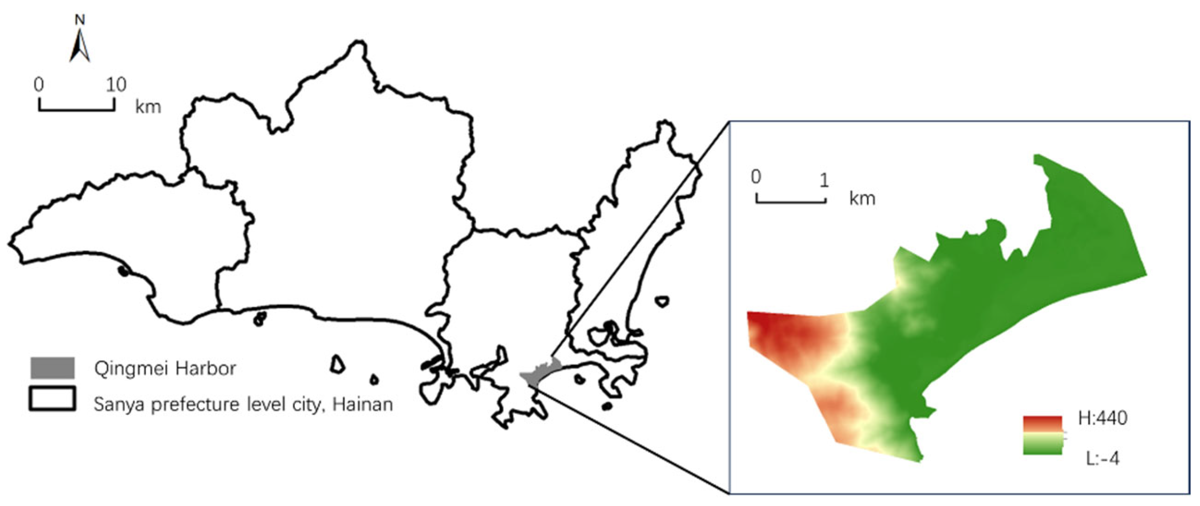
Figure 2.
Current land use situation in Qingmei Harbor from 2009 to 2022.
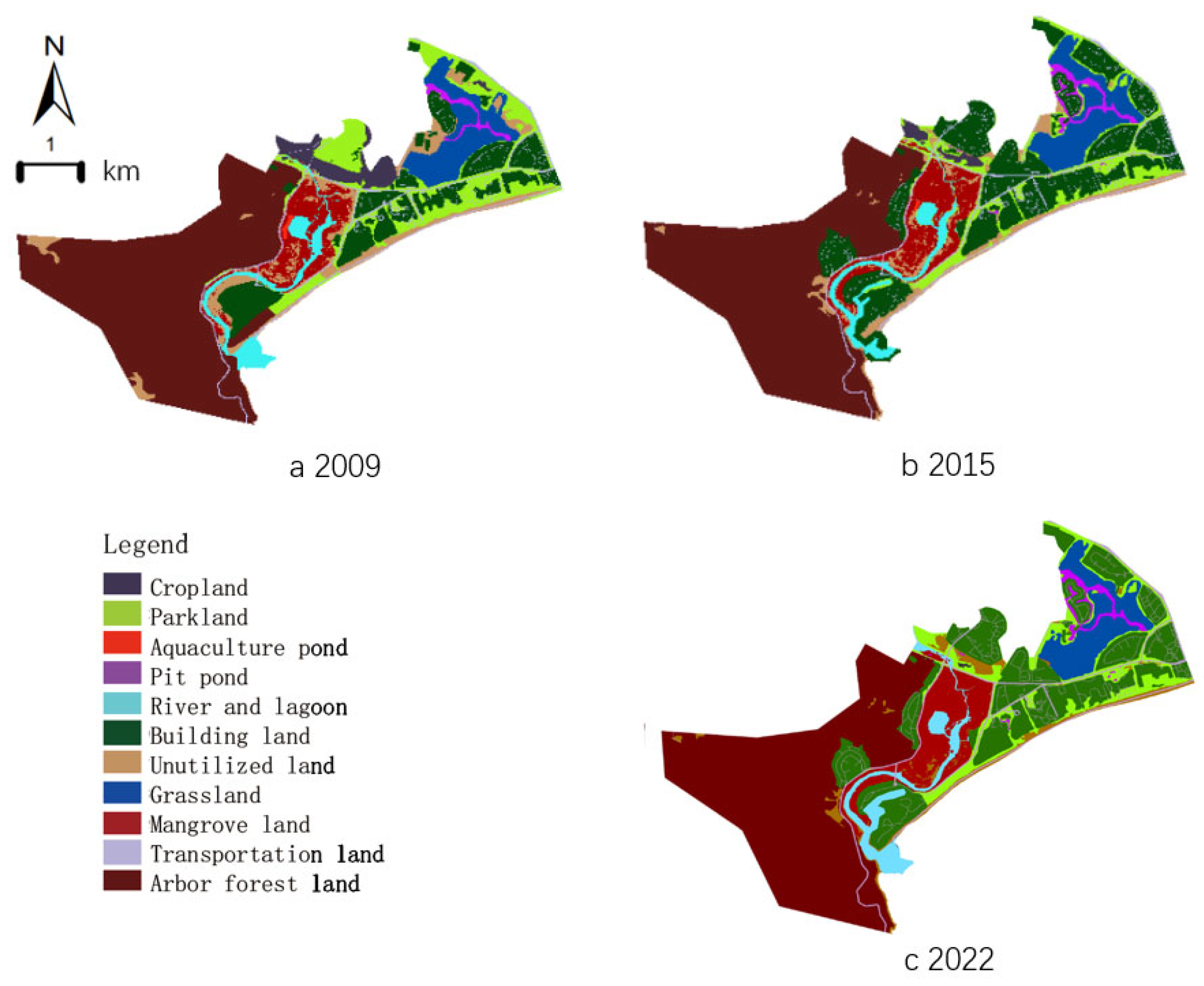
Figure 3.
Contribution of driving factors for land expansion in Qingmei Harbor from 2009 to 2022.
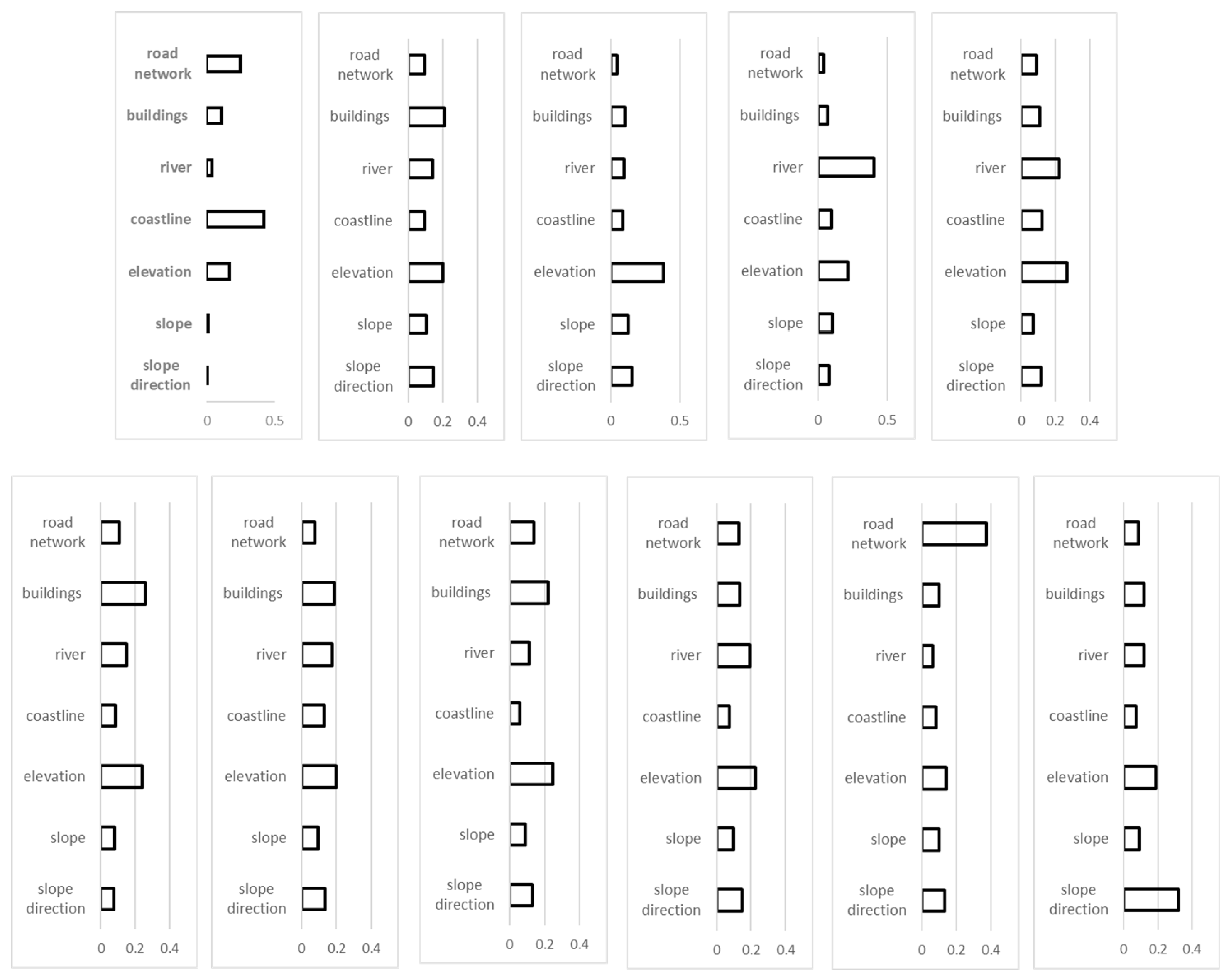
Figure 4.
Land use simulation under different scenarios in Qingmei Harbour in 2035.
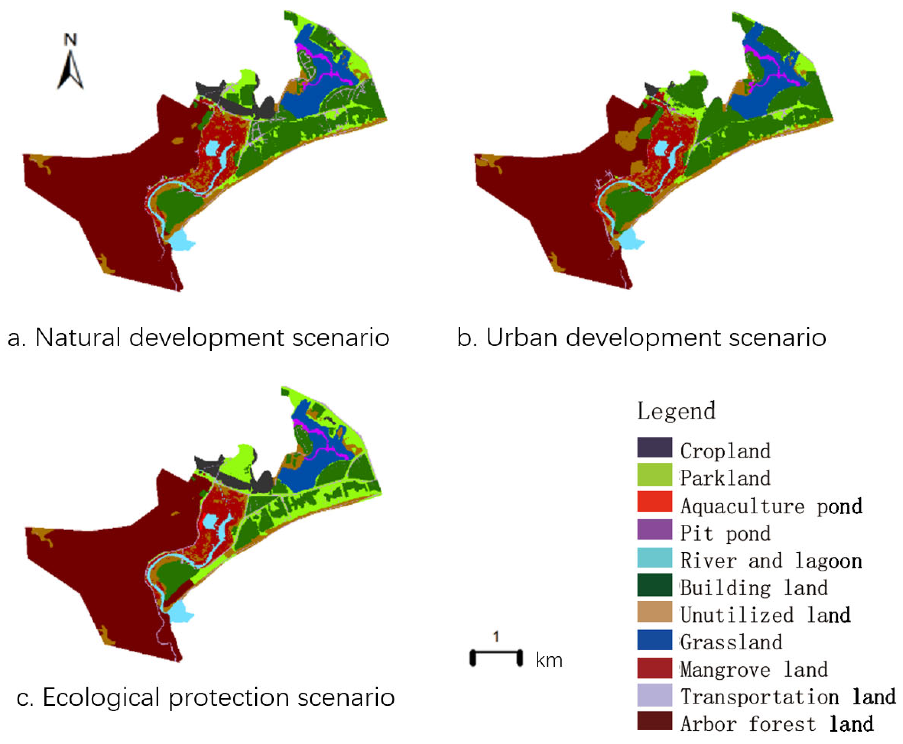

Table 1.
Land use attribute conversion matrix in each scenario.
| cropland | parkland | aquaculture pond, | pit pond | river and lagoon | building land | Unutilized land | grassland | mangrove land | transportation land | Arbor forest land | ||
| natural development scenario | cropland | 1 | 1 | 1 | 1 | 1 | 1 | 1 | 1 | 1 | 1 | 0 |
| parkland | 1 | 1 | 1 | 1 | 1 | 1 | 1 | 1 | 1 | 1 | 1 | |
| aquaculture pond | 1 | 1 | 1 | 1 | 1 | 1 | 1 | 1 | 1 | 1 | 0 | |
| pit pond | 1 | 1 | 1 | 1 | 0 | 0 | 0 | 0 | 0 | 0 | 0 | |
| river and lagoon | 1 | 1 | 1 | 0 | 1 | 1 | 1 | 1 | 1 | 1 | 1 | |
| building land | 1 | 1 | 1 | 1 | 1 | 1 | 1 | 0 | 1 | 1 | 1 | |
| Unutilized land | 1 | 1 | 1 | 1 | 1 | 1 | 1 | 0 | 0 | 1 | 0 | |
| grassland | 0 | 0 | 0 | 0 | 0 | 0 | 0 | 1 | 0 | 0 | 0 | |
| mangrove land | 0 | 0 | 0 | 0 | 0 | 0 | 1 | 0 | 1 | 0 | 0 | |
| transportation land | 1 | 1 | 1 | 1 | 1 | 1 | 1 | 1 | 1 | 1 | 1 | |
| Arbor forest land | 1 | 1 | 0 | 1 | 1 | 1 | 1 | 1 | 1 | 1 | 1 | |
| urban development scenario | cropland | 1 | 0 | 0 | 0 | 0 | 0 | 0 | 0 | 0 | 0 | 0 |
| parkland | 0 | 1 | 1 | 1 | 1 | 1 | 1 | 1 | 1 | 1 | 1 | |
| aquaculture pond | 0 | 1 | 1 | 1 | 1 | 1 | 1 | 0 | 1 | 1 | 1 | |
| pit pond | 0 | 0 | 1 | 1 | 0 | 0 | 0 | 0 | 0 | 0 | 0 | |
| river and lagoon | 0 | 1 | 1 | 0 | 1 | 1 | 1 | 0 | 1 | 1 | 1 | |
| building land | 0 | 1 | 1 | 1 | 1 | 1 | 1 | 0 | 1 | 1 | 1 | |
| Unutilized land | 0 | 1 | 1 | 1 | 0 | 1 | 1 | 1 | 0 | 1 | 0 | |
| grassland | 0 | 0 | 0 | 0 | 0 | 0 | 0 | 1 | 1 | 0 | 0 | |
| mangrove land | 0 | 0 | 0 | 0 | 0 | 0 | 1 | 0 | 1 | 0 | 0 | |
| transportation land | 0 | 1 | 1 | 1 | 1 | 1 | 1 | 1 | 1 | 1 | 1 | |
| Arbor forest land | 0 | 1 | 0 | 1 | 1 | 1 | 1 | 0 | 1 | 1 | 1 | |
| ecological protection scenario | cropland | 1 | 1 | 1 | 1 | 1 | 0 | 0 | 0 | 1 | 1 | 1 |
| parkland | 1 | 1 | 1 | 1 | 1 | 0 | 0 | 1 | 1 | 0 | 1 | |
| aquaculture pond | 1 | 1 | 1 | 1 | 1 | 0 | 0 | 0 | 1 | 0 | 1 | |
| pit pond | 1 | 1 | 1 | 1 | 1 | 0 | 0 | 0 | 1 | 0 | 1 | |
| river and lagoon | 1 | 1 | 1 | 1 | 1 | 0 | 0 | 0 | 1 | 0 | 1 | |
| building land | 1 | 1 | 1 | 1 | 1 | 1 | 1 | 1 | 1 | 1 | 1 | |
| Unutilized land | 0 | 1 | 1 | 1 | 1 | 1 | 1 | 0 | 0 | 1 | 0 | |
| grassland | 0 | 0 | 0 | 0 | 0 | 0 | 0 | 1 | 0 | 0 | 0 | |
| mangrove land | 0 | 0 | 1 | 0 | 1 | 0 | 0 | 0 | 1 | 0 | 1 | |
| transportation land | 1 | 1 | 1 | 1 | 1 | 1 | 1 | 1 | 0 | 1 | 0 | |
| arbor forest land | 0 | 0 | 0 | 0 | 0 | 0 | 0 | 0 | 1 | 0 | 1 |
Table 2.
Area of each land use type in Qingmei Harbor from 2009 to 2022/ha.
| Landscape Types | 2009 | 2015 | 2022 | |||
| area(ha) | Proportion(%) | area(ha) | Proportion(%) | area(ha) | Proportion(%) | |
| Cropland |
26.89 | 3.40 | 7.00 | 0.88 | 0.40 | 0.05 |
| Parkland |
92.55 | 11.69 | 56.25 | 7.11 | 59.47 | 7.51 |
| Aquaculture pond |
1.19 | 0.15 | 0.40 | 0.05 | 0.00 | 0.00 |
| Pit pond |
6.49 | 0.82 | 11.05 | 1.40 | 10.92 | 1.38 |
| River and lagoon |
27.83 | 3.52 | 24.67 | 3.12 | 34.82 | 4.40 |
| Building land |
104.83 | 13.25 | 186.93 | 23.62 | 184.20 | 23.27 |
| Unutilized land |
58.80 | 7.43 | 42.41 | 5.36 | 28.11 | 3.55 |
| Grassland |
52.36 | 6.62 | 51.94 | 6.56 | 52.63 | 6.65 |
| Mangrove land |
45.49 | 5.75 | 54.51 | 6.89 | 65.26 | 8.25 |
| Transportation land |
27.30 | 3.45 | 32.42 | 4.10 | 32.42 | 4.10 |
| Arbor forest land |
347.72 | 43.93 | 323.86 | 40.92 | 323.60 | 40.89 |
Table 3.
Land use types changes in Qingmei Harbor.
| Landscape Types | 2009-2015 | 2015-2022 | 2009-2022 | |||
| Change area(ha) | Dynamic Degree(%) |
Change area(ha) | Dynamic Degree(%) |
Change area(ha) | Dynamic Degree(%) |
|
| Cropland |
-15.54 | -73.97 | -5.16 | -94.33 | -20.70 | -98.52 |
| Parkland |
-28.36 | -39.22 | 2.51 | 5.72 | -25.85 | -35.75 |
| Aquaculture pond |
-0.62 | -66.40 | -0.31 | -100.00 | -0.93 | -100.00 |
| Pit pond |
3.56 | 70.25 | -0.11 | -1.22 | 3.46 | 68.17 |
| River and lagoon |
-2.47 | -11.34 | 7.93 | 41.14 | 5.46 | 25.13 |
| Building land |
64.14 | 78.32 | -2.13 | -1.46 | 62.01 | 75.71 |
| Unutilized land |
-12.81 | -27.88 | -11.17 | -33.72 | -23.98 | -52.20 |
| Grassland |
-0.33 | -0.80 | 0.53 | 1.32 | 0.21 | 0.51 |
| Mangrove land |
7.04 | 19.82 | 8.40 | 19.74 | 15.45 | 43.47 |
| Transportation land |
4.01 | 18.78 | 0.00 | 0.00 | 4.01 | 18.78 |
| Arbor forest land |
-18.63 | -6.86 | -0.21 | -0.08 | -18.84 | -6.94 |
Table 4.
Areas of various land use types in Qingmei Harbour under different scenarios in 2035.
| Land use type | Natural development scenario | Urban development scenario | Ecological protection scenario | |||
| percentage (%) | area (ha) | percentage (%) | area (ha) | percentage (%) | area (ha) | |
| Cropland | 3.04 | 30.22 | 0.70 | 6.97 | 3.03 | 30.10 |
| Parkland | 11.20 | 111.35 | 9.74 | 96.79 | 16.45 | 163.56 |
| Aquaculture pond | 0.02 | 0.25 | 0.02 | 0.25 | 0.11 | 1.06 |
| Pit pond | 0.79 | 7.83 | 0.84 | 8.34 | 0.72 | 7.16 |
| River and lagoon | 2.66 | 26.47 | 2.66 | 26.47 | 3.05 | 30.30 |
| Building land | 16.81 | 167.07 | 21.52 | 213.90 | 11.88 | 118.11 |
| Unutilized land | 10.04 | 99.78 | 11.69 | 116.20 | 9.42 | 93.69 |
| Grassland | 6.05 | 60.14 | 6.39 | 63.50 | 5.81 | 57.72 |
| Mangrove land | 5.77 | 57.35 | 6.27 | 62.33 | 5.23 | 51.95 |
| Transportation land | 2.68 | 26.62 | 1.44 | 14.27 | 2.26 | 22.49 |
| Arbor forest land | 40.95 | 407.09 | 38.74 | 385.16 | 42.05 | 418.04 |
Disclaimer/Publisher’s Note: The statements, opinions and data contained in all publications are solely those of the individual author(s) and contributor(s) and not of MDPI and/or the editor(s). MDPI and/or the editor(s) disclaim responsibility for any injury to people or property resulting from any ideas, methods, instructions or products referred to in the content. |
© 2024 by the authors. Licensee MDPI, Basel, Switzerland. This article is an open access article distributed under the terms and conditions of the Creative Commons Attribution (CC BY) license (http://creativecommons.org/licenses/by/4.0/).
Copyright: This open access article is published under a Creative Commons CC BY 4.0 license, which permit the free download, distribution, and reuse, provided that the author and preprint are cited in any reuse.


