Submitted:
14 August 2024
Posted:
16 August 2024
You are already at the latest version
Abstract
Protected and conserved areas are a key area-based strategy to address the biodiversity and climate change crises. Fundamental to understand their performance over time are indicators. The Digital Observatory for Protected Areas (DOPA) was born in 2013 as a set of open access web services and applications to be used to assess, monitor, and report on protected and conserved areas. For over a decade it has delivered over 50 indicators to support policy processes, national and regional governments, and practitioners. DOPA has also developed a versatile and efficient back-end approach that is widely applicable in other area-based conservation contexts. Here, we describe the methods and workflows behind DOPA´s back end and provide examples of policy relevant questions it can answer. We discuss key advantages and limitations of this systematic and replicable approach and explore the use of this back-end architecture to inform progress in area-based conservation targets for the following decades. This approach, embedded in multiple services provided by the Knowledge Centre for Biodiversity of the European Commission (KCBD), can also support the implementation and monitoring of area-based targets of the Kunming Montreal Global Biodiversity Framework at international, regional, and national levels.
Keywords:
protected areas indicators
; area-based conservation
; spatial planning
1. Introduction
The world faces a multifaceted environmental crisis, often referred as the double (biodiversity loss and climate change) or triple (biodiversity loss, climate change, and pollution) crisis (UNFCCC, 2022) which is pushing the capacity of the planet to its limits (Steffen et al., 2015). The drivers behind these pressures that are causing biodiversity loss are well known and include land and sea use change, over-exploitation, introduction of invasive alien species, climate change, and pollution (IPBES, 2019). Over the last decades, several policy responses to this crisis have shaped international, regional and national policy. The 2030 United Nations agenda and its 17 Sustainable Development Goals (SDGs) (United Nations General Assembly, 2015), or more recently, in 2022, the new Kunming Montreal Global Biodiversity Framework (KM-GBF) agreed by the parties of Convention on Biological Diversity (CBD) (CBD, 2022), are notable examples of such processes.
One of the recurring strategies to tackle biodiversity loss and climate change, included these multilateral agreements, is area-based conservation (Bhola et al., 2021; Maxwell et al., 2020). Area based conservation involves using spatial planning to identify specific places and prioritize actions to advance in the biodiversity conservation agenda. One example of this is international agreements on goals and targets focused on protected areas for over 50 years (Gurney et al., 2023). These aim to increase the effectiveness and coverage of protected areas to halt biodiversity loss. IUCN defines protected areas as “A clearly defined geographical space, recognised, dedicated and managed, through legal or other effective means, to achieve the long-term conservation of nature with associated ecosystem services and cultural values”(Dudley, 2008). The term “conserved areas” is also used to recognise other area-based measures that do not meet the IUCN definition of protected areas but still provide conservation benefits. In the context of the CBD, Other Effective Area Based Conservation Measures (OECMs) are the best example of this (Alves-Pinto et al., 2021). Well managed, governed and appropriately resourced protected and conserved areas (hereafter “PACs”) are today critical strategies to halt biodiversity loss. However, although PACs are a fundamental building block of area-based conservation and one of the most widespread protection mechanisms on earth, they will not be able by themselves to stop biodiversity loss. Integrated spatial planning across the whole landscape is needed to, for example, address and manage pressures on PACs and biodiversity. Supporting this, Target 1 of the KM-GF calls to ensure “all areas are under participatory, integrated, and biodiversity inclusive spatial planning…”(CBD, 2024).
Metrics and indicators are developed to determine whether PACs goals and targets set in policy domains have been achieved. For example, the KM-GBF includes Target 3 that calls for increasing the quantity and quality of PACs to cover 30% of the globe including sites important for biodiversity and ecosystem services (CBD, 2022). Target 3 headline indicator is Coverage of Protected Areas and OECM (CBD, 2024). Similarly, regional and national efforts are aligning with these Goals. The European Union (EU) for example is committing through Target 3 of the EU Biodiversity Strategy to “Legally protect a minimum of 30% of the EU’s land area and a minimum of 30% of the EU’s sea area, and integrate ecological corridors, as part of a true Trans-European Nature Network.” Examples of EU indicators to monitor progress for this target include Terrestrial and Marine Protected Area Coverage and Natura 2000 Terrestrial and Marine Protected Area Coverage (EC, 2020).
To support the European Union’s efforts and capacity to mobilize and use biodiversity data so that they are readily accessible to policymakers, managers, researchers and other users, the Digital Observatory for Protected Areas (DOPA) was developed by the Joint Research Centre of the (JRC) European Commission (Dubois et al., 2013). Specifically, its original purpose was to periodically provide up to date metrics and indicators on protected areas from global to site scale. DOPA was built on web-based technologies, pulling together global datasets that were further processed before being integrated into key indicators which could then be shared through web services and applications (Bastin et al., 2017; Dubois et al., 2016). Its front end, the DOPA Explorer, was designed to provide protected area indicators efficiently, systematically, and periodically. Since then, the DOPA has been endorsed by the Convention on Biological Diversity as a reference tool that can help Parties as well as the CBD Secretariat assess progress towards related targets (UNEP, 2018). The DOPA also became the technical backbone of a large conservation programme, the Biodiversity and Protected Areas Management (BIOPAMA) programme that assists the African, Caribbean and Pacific countries to address their priorities for improved management and governance of biodiversity and natural resources (www.biopama.org). Most importantly, the DOPA is the main platform used by the European Commission’s in house science service, the Joint Research Centre, to provide the EC with the scientific and technical support on global biodiversity required to assess and prioritize conservation efforts.
In face of the key role spatial planning in general and area-based conservation in particular will take over the next decades (Hoffmann, 2022), and responding to user demands in the past years, DOPA´s back end has evolved since Dubois et al. (2016) beyond being a protected area focused platform to an area-based conservation service developed and delivered by the EC. To do this an innovative and versatile back-end approach to answer area-based conservation questions in much less time than before has been developed building from experience and user feedback over the past 10 years.
Here we present the current workflows and methods of this new back-end architecture, and show examples of its applications, uses, and policy relevance. We then discuss the innovation and versatility aspects, key advantages, and limitations of its systematic and replicable approach. Finally, we explore the benefits of this design to ensure consistency and repeatability over time and discuss the future of this architecture to inform progress in area-based conservation targets in the following decades through a series of services and applications.
2. Methods: Developing a New Back-End Approach for Area-Based Planning
DOPA back-end was developed to produce, using globally consistent datasets, protected area indicators at a global, regional, national, and site level to inform area-based conservation decisions at different scales (Dubois et al., 2013).
The need to regularly update figures and to provide up-to-date metrics on a wide range of indicators, using the latest releases of relevant datasets while maintaining previous versions, required finding solutions to a number of technical challenges and exploring ways of reducing long processing times that hindered timely updates (Bastin et al., 2017).
The lessons learned over a decade of history of DOPA led to an approach which main purpose was to reduce the computational effort needed to deliver quickly and efficiently values for any of over 50 indicators in any part of the world. Four steps were followed to improve the quality and speed of the process. First, create a structured and standardized workflow to avoid desktop analysis conducted by different operators with different tools, methods, speeds and outputs. Second, to reduce the number of steps needed by developing a base layer (which also provides the principal coverage indicators) and intersecting it with a series of thematic datasets (aggregated too, when possible), to calculate the rest of the metrics. Third simplify complexity of the numerous global datasets used by flattening the data (i.e., reducing overlaps) and harmonizing boundaries. Finally, optimize the process by parallelizing calculations (i.e., use different cores for computation) and reducing redundant processes.
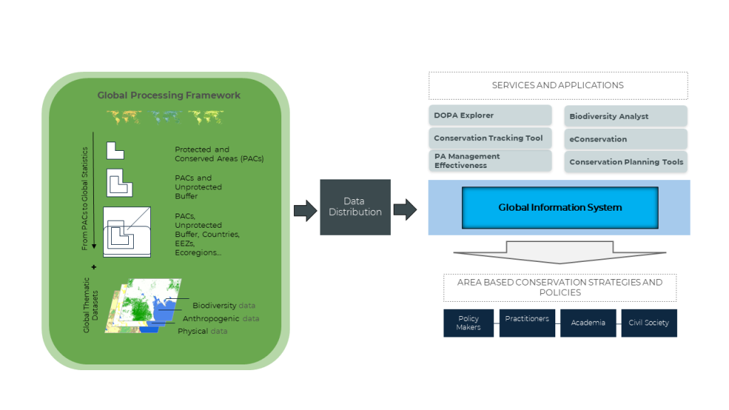
The new back-end approach is underpinned by a global processing framework that delivers a pre-processed database used for storage, post-processing, and distribution for analytical and reporting tools. The distribution is done via REST services to feed a series of web services, and applications aimed to inform conservation strategies and policies for a variety of users (Figure 1). A notable example of these applications is the DOPA front end called DOPA Explorer (Dubois et al., 2016).
The new workflow consists of a sequence of bash scripts which in turn launch in parallel a series of PostGIS functions, and is divided into three distinct phases (Table 1): i) Pre-processing, where key core and some of the thematic datasets are standardised and stored into a relational, spatial-enabled, database; ii) Processing, where base and thematic dataset are intersected; iii) Post-processing, where raw results are aggregated, according to both standards (e.g., DOPA Explorer) or on-demand (e.g., a specific reporting for a region, a subset of species assessment, etc.) aggregations. A detailed technical description of these workflows are available in Supplementary Data 1.
2.1. Pre-Processing
In the pre-processing stage, baseline and thematic datasets are standardized and stored into a database (Table 1). Baseline Inputs include administrative layers such as Global Administrative Units (FAO, 2015) or the Economic Exclusions Zones (EEZ), Terrestrial and marine ecoregions (i.e., TEOW, MEOW, PPOW), and Protection (the World Database on Protected Areas and OECMs -WDPA/OECM); Thematic inputs include for example global species ranges from the IUCN Red List of Threatened Species, or Carbon stocks. All the datasets used are open access for their use in conservation.
The CEP (Country-Ecoregion-Protection) is considered as a core output in this stage and is used here as a representative example of a pre-processing workflow. The grid and the input datasets (in this case the country, ecoregions and protected areas data) are intersected each other and with a one-degree global grid using PostGIS scripts.
The intersection in each individual tile is performed in parallel on a different thread of a multi-core server, with ordering inversely proportional to the number of nodes (the higher the complexity, the sooner they are launched). The more complex tiles, which require more time, are all calculated at the beginning, and the simpler ones at the end, to optimize calculation times, and not wait for the processing to conclude for a single, very complex tile.
The result is a spatial table, in which each of the 64,800 tiles has a unique ID (qid) and contains multi polygons, named cid according to the unique combination of the original, overlapping, components (Country/Ecoregion/Protection=CEP). This table is a Ppseudo-topology, a flat simple feature layer which keeps, at the level of each single atomic (=indivisible) geometry resulting from the intersection of the overlapping input layers, all the information from the original sources. Consequently, each individual polygon of CEP represents a unique combination of country, ecoregion and protected area(s) and is identified by the unique numeric identifier cid. The same treatment is applied to the IUCN and Birdlife species dataset. The result is a vector spatial table and an equivalent raster partitioned in 1 degree tiles, where ~26,000 species ranges are 'flattened' in 6 layers representing corals, sharks, amphibians, reptiles, birds and mammals (for example, the ~11,000 bird species 2023 were flattened in a single spatial table of ~30 million records, where each cid object represents up to ~700 overlapping species).
The main output of this stage is the pre-processed relational database which includes the CEP, pre-processed species data, and other pre-processed thematic datasets (Table 1, SD1 for further details about preprocessing stage).
During the Pre-processing stage there are also workflows aimed at generating standardized datasets that are subsequently used for computation of specific indicators. The most significant example is the Carbon stocks workflow, where, starting from two publicly available datasets (FAO Soil Organic Carbon and ESA-CCI Above Ground Biomass), three new global datasets are derived: Below Ground Carbon (based on Above Ground Biomass root-to-shoot ratios published by IPCC 2019) , Dead Wood Carbon and Litter Carbon (following the procedure described in Harris et al, 2021). The final five Carbon stocks are then summed up to derive the Total Carbon stocks dataset (See Supplementary data 1 for further details).
2.2. Processing
This stage involves the spatial intersection of the base dataset (CEP), created in the previous phase and stored in the pre-processing database, with a series of global thematic datasets. The aim is to calculate relevant raw statistics that in the post-processing phase will be aggregated to derive a series of biodiversity indicators. It is developed using bash/GRASS-GIS functions, which provide a set of simple and computationally efficient tools for raster data processing
Based on the type of raster dataset to be intersected with CEP, two different GRASS functions are used: i) Categorical rasters: the surface in square meters of each category of the raster is computed for each object (cid) of the CEP (r.stats module); ii) Continuous rasters: basic univariate statistics (n. of non-null cells, min, max, range, mean, st.dev., variance, coeff. of variation, 1st, s2nd, 3rd quartile, 90th percentile) are computed for each object (cid) of the CEP (r.univar module). Regardless of the function used, the analysis is always performed at the resolution of the thematic dataset (the resolution of the raster datasets currently used in DOPA is in the range 30m - 1km).
The computational approach is based on parallelization which can be summarised in 3 steps:
- The global CEP dataset is created in one-degree tiles and then aggregated into a 10x10 degrees grid, for a total of 648 tiles covering the globe.
- The relevant GRASS function is run in parallel on each single tile, where processing in a single tile is assigned to a different core of a multi-core server. With the aim of making the best use of available memory, the number of cores used for parallelization is optimized for each thematic dataset and is inversely proportional to the resolution of the raster to be processed (the higher the resolution, the more memory is allocated for each process).
- Output statistics for each tile are merged into a single csv file, which is subsequently imported as table in Postgres SQL database.
For example, the intersection between CEP and IUCN species ranges for birds is completed in a single run, and the raw results are non-spatial tables, reporting surface in sqm by the intersecting qids (tiles) and cids (unique identifiers of the original combinations of objects) from both CEP and birds. The birds raw_result table contains ~34 million records.
2.3. Post-Processing
This stage involves the aggregation of raw statistics computed on CEP during the previous step and the built-up of the metric for a relevant indicator and for the relevant reporting levels (i.e., country and/or ecoregion and/or PAC).
The aggregation of raw statistics is performed in two steps:
- Two general SQL functions for post-processing of raw statistics (one for categorical and one for continuous raster datasets, respectively) have been developed. The appropriate function is run using as input the raw statistics table of each dataset and producing in output an intermediate table, where statistics are rebuilt for each individual object through aggregation of all relevant unique elements, using the qid and cid codes.
- For each indicator, a specific script, tailored for the needs of the corresponding metric, process the intermediate table and returns the final metric for each of the relevant reporting levels, ready for distribution via REST and web services.
Following our example, the original components of the previous CEP/birds intersections would be expanded in two steps (before by CEP cid, then by birds cid) using sql scripts, and reaggregated according to multiple criteria. The results are the standard checklists and spatial coverages by country, ecoregion, and protected areas; but also protected portion in country, land portion in country, protected land portion in country, protected portion in ecoregion, protected portion of ecoregion in country, and a series of indicators summarise in Supplementary Data 1 (SD2).
This approach allows the production of the requested metrics for each reporting level (protected area, country, ecoregion) quickly and efficiently. Despite the starting raw statistics tables have usually several hundreds of thousands (sometimes millions) of rows, data aggregation functions work only on numeric attributes (no operations are performed on geometries), which requires very little processing times compared to processing geometries.
3. Results: Implementing the Back-End
The back-end architecture approach to calculate area-based conservation indicators described above significantly reduced the processing time for protected area indicators. For example, originally the system took approximately 6 months to process one single indicator for 16,000 protected areas larger than 100 km2 using traditional GIS tools. Today, this time has been reduced to approximately 40 days (considering only the processing time) to process over 50 indicators with global coverage, including over 270,000 protected areas, all countries and terrestrial, marine and pelagic ecoregions. A full list of metrics and indicators, including 16 themes, intersecting 28 sources, and distributing 1292 endpoints through 50 functions, is available on Supplementary Data 2.
More importantly, this new architecture can respond to several area-based conservation research and policy questions from global to local scales quickly and efficiently. For example, if the question is “What is the surface in sqkm of croplands within protected areas of Indonesia?” the processing sequence would be (see section 2.1. for definitions of cid and CEP):
- Compute flat CEP as described in section 2.1.
- Export flat CEP as raster tiles (10x10 degrees wide; 30 meters spatial resolution) and import them into GRASS DB.
- In GRASS, compute areas by categories using the latest available version of Copernicus Land Cover (100m spatial resolution). The result is a non-spatial table with coverage values in sqkm of all categories of land cover for each cid of CEP.
- Import the non-spatial table in Postgres.
-
Aggregate again the cids accordingly through
- Selection of cids satisfying the criteria included in the original question (iso3=’IDN’ AND is_protected IS true AND lc_class=’cropland’)
- Sum up of coverages for selected cids
- Final metric is the area in sqkm of croplands within protected areas of Indonesia
Steps 1-4 are the more time-consuming steps and are run only once for each update of DOPA indicators. Once these raw statistics are available as table in the PostgreSQL database, only step 4 (a simple, quick and inexpensive query) is required to answer the question.
The implementation of the workflow comes to life through two specific applications we use here as an example: computing of global indicators to support biodiversity policy reporting and spatial conservation planning for renewable energy in the EU.
3.1. Global Indicators to Support International Biodiversity Policy Reporting
Most countries in the world agreed to the KM-GBF to be achieved by 2050 with 2030 milestones. These include 23 targets of which Target 3 calls of a global network of PACs that covers 30% of the globe and is well connected, ecologically representative, governed and effectively managed, among other important attributes. Similarly, the 17 SDGs of UNs 2030 agenda (United Nations General Assembly, 2015) include Goal 14 and Goal 15 for which a protected area global and national coverage indicator calculation is needed. Fundamental to track progress towards these targets and goals, and to facilitate country reporting (especially for countries with low technical capacity) is to offer easily accessible and up to date international and national relevant metrics and indicators. Through the workflows and techniques described above, the DOPA back-end can provide this. For example, policy indicators at a national, regional, and global level that are recalculated regularly (Table 2) or more sophisticated analyses combining connectivity and protection metrics (Figure 2).
3.2. Spatial Conservation Planning for Renewable Energy in the EU
The EU needs to assess risks and opportunities of approved policies and directives to ensure their effective implementation. In 2023, DOPA architecture was used to support the identification of go-to and no-go areas in EU 27 for the deployment of solar and wind farms. This consisted on developing checklists and maps of species richness outside and inside protected areas in the EU. The aim was to determine which endemic and threatened birds, mammals, amphibians and reptiles could be potentially threatened by the development of solar and wind farm development. The final result was a map that showed the areas in the EU where more threatened and endemic species could be impact by the development of renewable energy farms (Figure 3). This information is now publicly available at the EC Energy and Industry Geography Lab online platform (see https://energy-industry-geolab.jrc.ec.europa.eu/).
4. Discussion: The Future of DOPA Back End and Its Applications
Integrated spatial planning, across scales and within all sectors of society, has become key to tackle the environmental challenges over the next decades. This includes needs ranging from assessing the performance of conservation actions to avoiding and minimising impacts on biodiversity from human activity. Area-based conservation is a fundamental part of this as it focuses on the use of spatial planning tools to support decisions by governments, private and financial sector, and conservation practitioners on the conservation and management biodiversity in specific places (Bhola et al., 2021; Maxwell et al., 2020). Moreover, quick and efficient area-based analysis and tools are essential if we are to address the environmental challenges of the 21st century (Hoffmann, 2022)
The DOPA was developed, in its first decade, to produce protected area indicators at global, regional, national, and site level and inform area-based conservation decisions at different scales (Dubois et al., 2009). While the initial technological focus was on distributed services to ease data integration and address multidisciplinary challenges (Pearlman et al., 2010) including increased modelling capabilities (Dubois, et al., 2011), reporting needs and fast support to policy requests have been shifting efforts towards more reliable tools and faster updates of indicators (Dubois et al., 2013, 2016). Here we describe how, building from the development of the DOPA and responding to user and policy needs, the back-end architecture and analytical approach of DOPA has developed over the years pursuing speed and efficiency. Timely and up to date biodiversity information, data, and metrics at global, national, and site level scale can now be provided in a speed that was not possible before. Moreover, it allows to answer specific questions such as the risk exposure of a specific point in the globe, or the attributes of any of the over 250,000 protected and conserved areas globally. Below, we discuss further the novelty of this approach, the infrastructure design and governance, and its potential to support policy process at different scales and inform area-based conservation decisions over the next decades.
4.1. Achieving Technical Efficiency through Innovation
The novelty of this approach does not reside in the actual methods and techniques applied but in the design of the back end and its implementation driven by the need to meet user needs. Each step and tool have been carefully selected and tested to maximise efficiency and speed. Decoupling the tabular data to the geometry has greatly speeded up the process as well as the application flattening and parallelization, two very common GIS techniques that together significantly reduce the processing times.
Fundamental to this approach is the fact that DOPA is built and based on open code and open access tools and that it uses global datasets that are also open access for conservation purposes under specific terms of use. Limitations still exist in using some of these global datasets for commercial purposes, this is by for-profit organisations such as companies, independent consultants or financial institutions. However, this is bound to be changing in a world where increasingly conservation practitioners, policy makers, impact assessors, businesses and local communities need access to biodiversity data for informed decision-making on natural resource management (Stephenson & Stengel, 2020).
4.2. Integrated System Design and Governance
DOPA's high-level back-end architecture emphasises a co-design approach that integrates global monitoring with the flexibility for regional national adaptation. This dual approach, involving both bottom-up and top-down processes, establishes a global baseline while allowing regional and national entities to adapt or complement this baseline with local inputs. This dynamic is moderated and further verified by regional and sub-regional hubs with potential local engagement.
The new back-end approach also offers a versioning scheme and licensing considerations to ensure traceability and uptake over time. The process plays a key role in data verification, ensuring the integrity and accuracy of datasets from different sources, particularly national and local. This is critical to incorporate diverse data and knowledge inputs, as well as indigenous and local knowledge. Moreover, the structured and openly-linked handling of datasets - including ontology, namespaces, topics and controlled vocabularies - addresses current terminological confusion. An ontology for key variables and indicators, independent of thematic content, and the establishment of controlled vocabularies is fundamental to ensure clarity and consistency in data interpretation and use.
4.3. Developing Indicators for Area Based Conservation 2030 -2050
The back-end developed through DOPA has the potential to become a reference model and resource for supporting third parties in their area-based conservation efforts towards implementing and achieving the 2030 and 2050 goals and targets. This architecture offers the means to further channel biodiversity data into policy and decision making by providing an effective means to convert data into indicators and sharing these via REST Services. This includes serving key international, regional, and national policy processes supporting decisions for national governments and policy makers but also connecting to other global initiatives such as the Global Biodiversity Observing System (GBiOS). GBiOS, is a proposal from the Group on Earth Observations Biodiversity Observation Network (GEO BON), and its partners, that would combine technology, data, and knowledge from around the world to foster collaboration and data sharing among countries (Gonzalez et al., 2023).
For example, at the international level the KM-GBF includes Target 3 for which most components need area-based planning global calculations. As explained here, DOPA has already been serving protected are coverage, ecoregions (UNEP-WCMC, 2020) and connectivity metrics and indicators (Saura et al., 2019) to inform Aichi Target 11 of the previous GBF (CBD, 2010) and will continue to provide this to monitor progress towards the achievement of the new targets under the KM-GBF. In addition, Target 1 calls for “…participatory, integrated, and biodiversity inclusive spatial planning” (CBD, 2022). This includes the indicator “Percent of land and seas covered by biodiversity-inclusive spatial plans” which methodology is yet to be developed (CBD, 2024). The new back-end infrastructure could serve directly as a resource for calculating and providing this indicator or as a model of work that can easily be replicated by anyone. Along the same lines, this architecture could also be adopted by the global knowledge support service for biodiversity (GKSSB, https://gkssb.chm-cbd.net/) that is currently under discussion at the CBD. This initiative, launched during CBD COP15 and led by UNEP-WCMC and its partners, aims to connect existing biodiversity knowledge hubs and other biodiversity-related data providers and tools to support national institutions in implementing and achieving the KM-GBF targets (UNEP-WCMC, 2022).
At the regional level, the EU biodiversity strategy commits to achieve 16 targets by 20230 (EC, 2020). To support the implementation of this strategy, the European Commission established the Knowledge Centre for Biodiversity (KCBD) in October 2020 to help monitor progress towards its actions and targets (EC, 2024). The indicators used and reported by the KCBD are derived from a variety of EU reporting schemes (e.g. Member States are reporting data on a number of indicators, including protected areas coverage) or obtained from independent sources (e.g., the grassland butterfly index, based on citizen science and sourced from the European Butterfly Monitoring Scheme partnership established by Butterfly Conservation Europe) (Viti et al., 2024). From a policy point of view, the DOPA, by providing area based conservation elements of the EU and the global biodiversity strategies independently from the data reported by countries provides useful information that can be used to highlight potential discrepancies and help understand underlying causes. The DOPA also provides a well-documented open infrastructure that can help identify and structure complex information neeed by researchers, policy-makers, NGOs, industry and citizens.
Nationally, the switch from site-based conservation to consider the wider landscape requires more sophisticated analyses for the whole landscape matrix and its actors. However, the infrastructure can easily be customised to take more local datasets into account and support integrated spatial planning and coordination between government agencies, proving quick nationwide answers to key policy and conservation action questions. This also includes, assessing biodiversity risk for private companies and financial institutions in two ways: first to facilitate business corporate sustainability reporting in compliance with, for example, EU CSRD regulation (EU, 2022); second to support private sector decisions to avoid and minimize impacts on biodiversity before they happen (see section 3.2. for an example).
5. Conclusion
The tools, workflows and processes developed through the evolution of DOPA have served metrics and indicators to a wide range of actors supporting biodiversity policy reporting for over a decade. Looking ahead, its architecture and back-end have the potential to further support the implementation of international, regional, and national policies through timely and quick provision of answers to inform decisions to face the environmental challenges of the next two decades. More importantly, the transparency of the processes and workflows of the DOPA and the low-cost infrastructure that is supporting it allows for its reuse by third Parties, and this for local to global analyses. The technical capabililty of DOPA´s back-end to easily integrate new indicators that can be delivered quickly and efficiently to other platforms should motivate its further developmemt and use in the fast changing landscape of biodiversity knowledge management.
Supplementary Materials
The following supporting information can be downloaded at the website of this paper posted on Preprints.org, Supplementary data 1 (SD1): Links to detailed methodologies and workflows: DOPA workflows: https://github.com/andreamandrici/dopa_workflow. Carbon processing worklflows: https://github.com/giacomo-gcad/carbon; Supplementary data 2 (SD2): The full list of parameters calculated by DOPA back ends is listed and updated in real time here: https://rest-services.jrc.ec.europa.eu/services/d6dopa/dopa_43/get_dopa_function_output_parameters?format=html.
Author Contributions
Conceptualization, G. Dubois, A. Mandrici, G. Delli, D.Juffe-Bignoli. and A. Niamir; methodology, A. Mandrici, G. Delli, , G. Dubois; software, A. Mandrici, G. Delli.; validation; writing—original draft preparation, D.Juffe-Bignoli, A. Mandrici, G. Delli, G. Dubois; writing—review and editing, D. Juffe-Bignoli, A. Mandrici, G. Delli, G. Dubois, A. Niamir; visualization, D. Juffe-Bignoli, A. Mandrici, G. Delli.; supervision, G. Dubois. All authors have read and agreed to the published version of the manuscript.
Funding
The DOPA has been developed via the institutional activities of the JRC as well as with funding from DG INTPA in the context of its administrative arrangement with the JRC “Support to the global dimension of the Knowledge Centre for Biodiversity established by the EU Biodiversity Strategy for 2030”.
Data Availability Statement
All data used by the DOPA are in the public domain as documented in the manuscript. Only a few datasets cannot be used for commercial purposes.
Acknowledgments
Many people have contributed to the development of DOPA over the past years. We are grateful to Lucy Bastin, Bastian Bertzky, Luca Batistella, Michele Conti, Santiago Saura, Andrew Cottam, Javier Martínez-López, Martino Boni, Mariagrazia Graziano, Michael Schulz, Javier Martínez-López, Luca Marletta.
Conflicts of Interest
The authors declare no conflicts of interest. The funders had no role in the design of the study; in the collection, analyses, or interpretation of data; in the writing of the manuscript; or in the decision to publish the results.
References
- Alves-Pinto, H., Geldmann, J., Jonas, H., Maioli, V., Balmford, A., Ewa Latawiec, A., Crouzeilles, R., & Strassburg, B. (2021). Opportunities and challenges of other effective area-based conservation measures (OECMs) for biodiversity conservation. Perspectives in Ecology and Conservation, 19(2), 115–120. [CrossRef]
- Bastin, L., Mandrici, A., Battistella, L., & Dubois, G. (2017). Processing Conservation Indicators with Open Source Tools: Lessons Learned from the Digital Observatory for Protected Areas. Free and Open Source Software for Geospatial (FOSS4G) Conference Proceedings, 17(1). [CrossRef]
- Bhola, N., Klimmek, H., Kingston, N., Burgess, N. D., van Soesbergen, A., Corrigan, C., Harrison, J., & Kok, M. T. J. (2021). Perspectives on area-based conservation and its meaning for future biodiversity policy. Conservation Biology, 35(1), 168–178. [CrossRef]
- CBD. (2010). Strategic Plan for Biodiversity 2011-2020. Secretariat of the Convention on Biological Diversity. https://www.cbd.int/sp.
- CBD. (2022). Decision adopted by the conference of the parties to the convention on biological diversity 15/4. Kunming-Montreal Global Biodiversity Framework. https://www.cbd.int/doc/decisions/cop-15/cop-15-dec-04-en.pdf.
- CBD. (2024). Indicators for the Kunming – Montreal Global Biodiversity Framework. Indicator Repository. https://gbf-indicators.org/.
- Dubois, G., Bastin, L., Bertzky, B., Mandrici, A., Conti, M., Saura, S., Cottam, A., Battistella, L., Martínez-López, J., Boni, M., & Graziano, M. (2016). Integrating Multiple Spatial Datasets to Assess Protected Areas: Lessons Learnt from the Digital Observatory for Protected Areas (DOPA). ISPRS International Journal of Geo-Information, 5(12), Article 12. [CrossRef]
- Dubois, G., Schulz, M., Skoien, J., Cottam, A., Temperley, W., Clerici, M., Drakou, E., van´t Klooster, J., Verbeeeck, B., Palumbo, I., Derycke Pascal, Pekel, J. F., Martinez-Lopez, Peedell, S., & Mayaux, P. (2013). An introduction to the digital observatory for protected areas (DOPA) and the DOPA explorer (Beta). European Union. https://data.europa.eu/doi/10.2788/31842.
- Dudley, N. (2008). Guidelines for applying protected area management categories. IUCN. [CrossRef]
- EC. (2020). EU Biodiversity Strategy for 2030: Bringing nature back into our lives. https://eur-lex.europa.eu/legal-content/EN/TXT/?uri=celex%3A52020DC0380.
- EC. (2024). Knowledge Centre for Biodiversity. https://knowledge4policy.ec.europa.eu/biodiversity_en.
- EU. (2022, December 16). DIRECTIVE (EU) 2022/2464 OF THE EUROPEAN PARLIAMENT AND OF THE COUNCIL of 14 December 2022 amending Regulation (EU) No 537/2014, Directive 2004/109/EC, Directive 2006/43/EC and Directive 2013/34/EU, as regards corporate sustainability reporting. Official Journal of the European Union. https://eur-lex.europa.eu/legal-content/EN/TXT/PDF/?uri=CELEX:32022L2464.
- FAO. (2015). The Global Administrative Unit Layers (GAUL). https://data.apps.fao.org/catalog/dataset/global-administrative-unit-layers-gaul-2015.
- Gonzalez, A., Vihervaara, P., Balvanera, P., Bates, A. E., Bayraktarov, E., Bellingham, P. J., Bruder, A., Campbell, J., Catchen, M. D., Cavender-Bares, J., Chase, J., Coops, N., Costello, M. J., Czúcz, B., Delavaud, A., Dornelas, M., Dubois, G., Duffy, E. J., Eggermont, H., … Torrelio, C. Z. (2023). A global biodiversity observing system to unite monitoring and guide action. Nature Ecology & Evolution, 7(12), 1947–1952. [CrossRef]
- Gurney, G. G., Adams, V. M., Álvarez-Romero, J. G., & Claudet, J. (2023). Area-based conservation: Taking stock and looking ahead. One Earth, 6(2), 98–104. [CrossRef]
- Harris, N. L., Gibbs, D. A., Baccini, A., Birdsey, R. A., de Bruin, S., Farina, M., Fatoyinbo, L., Hansen, M. C., Herold, M., Houghton, R. A., Potapov, P. V., Suarez, D. R., Roman-Cuesta, R. M., Saatchi, S. S., Slay, C. M., Turubanova, S. A., & Tyukavina, A. (2021). Global maps of twenty-first century forest carbon fluxes. Nature Climate Change, 11(3), 234–240. [CrossRef]
- Hoffmann, S. (2022). Challenges and opportunities of area-based conservation in reaching biodiversity and sustainability goals. Biodiversity and Conservation, 31(2), 325–352. [CrossRef]
- IPBES. (2019). Summary for policymakers of the global assessment report on biodiversity and ecosystem services (Díaz, S., Settele, J., Brondízio, E. S., Ngo, H. T., Guèze, M., Agard, J., Arneth, A., Balvanera, P., Brauman, K. A., Butchart, S. H. M., Chan, K. M. A., Garibaldi, L. A., Ichii, K., Liu, J., Subramanian, S. M., Midgley, G. F., Miloslavich, P., Molnár, Z., Obura, D., Pfaff, A., Polasky, S., Purvis, A., Razzaque, J., Reyers, B., Roy Chowdhury, R., Shin, Y. J., Visseren-Hamakers, I. J., Willis, K. J., and Zayas C.N., Ed.). IPBES secretariat. [CrossRef]
- IPPC. (2019). Chapter 4: Forest Land. In 2019 Refinement to the 2006 IPCC Guidelines for National Greenhouse Gas Inventories. https://www.ipcc-nggip.iges.or.jp/public/2019rf/pdf/4_Volume4/19R_V4_Ch04_Forest%20Land.pdf.
- Maxwell, S. L., Cazalis, V., Dudley, N., Hoffmann, M., Rodrigues, A. S. L., Stolton, S., Visconti, P., Woodley, S., Kingston, N., Lewis, E., Maron, M., Strassburg, B. B. N., Wenger, A., Jonas, H. D., Venter, O., & Watson, J. E. M. (2020). Area-based conservation in the twenty-first century. Nature, 586(7828), 217–227. [CrossRef]
- Saura, S., Bastin, L., Battistella, L., Mandrici, A., & Dubois, G. (2017). Protected areas in the world’s ecoregions: How well connected are they? Ecological Indicators, 76, 144–158. [CrossRef]
- Saura, S., Bertzky, B., Bastin, L., Battistella, L., Mandrici, A., & Dubois, G. (2019). Global trends in protected area connectivity from 2010 to 2018. Biological Conservation, 238, 108183. [CrossRef]
- Steffen, W., Richardson, K., Rockström, J., Cornell, S. E., Fetzer, I., Bennett, E. M., Biggs, R., Carpenter, S. R., de Vries, W., de Wit, C. A., Folke, C., Gerten, D., Heinke, J., Mace, G. M., Persson, L. M., Ramanathan, V., Reyers, B., & Sörlin, S. (2015). Planetary boundaries: Guiding human development on a changing planet. Science, 347(6223), 1259855. [CrossRef]
- Stephenson, P. J., & Stengel, C. (2020). An inventory of biodiversity data sources for conservation monitoring. PLOS ONE, 15(12), e0242923. [CrossRef]
- UNEP. (2018, May). Actions towards achieving Aichi Biodiversity Target 11: Including areas of particular importance for biodiversity and improving ecological representation. UNEP/CBD/COP/22/INF/30. https://www.cbd.int/doc/notifications/2015/ntf-2015-027-pa-en.pdf.
- UNEP-WCMC. (2022). A global knowledge support service for biodiversity: Perspectives, options, and next steps. https://gkssb.chm-cbd.net/sites/gkssb/files/2023-02/GKSSB%20Discussion%20Paper%2013.12.22%20FINAL.pdf.
- UNEP-WCMC, I. (2020). Protected Planet Report 2020. Protected Planet Report 2020. https://livereport.protectedplanet.net.
- UNFCCC. (2022). What is the Triple Planetary Crisis? | UNFCCC. https://unfccc.int/news/what-is-the-triple-planetary-crisis.
- United Nations General Assembly. (2015). Transforming our world: The 2030 agenda for sustainable development, outcome document of the United Nations summit for the adoption of the post-2015 agenda, RES/A/70/L.1. United Nations, New York.
Figure 1.
Schematic representation of the back-end approach including high-level processes and workflows.
Figure 1.
Schematic representation of the back-end approach including high-level processes and workflows.
Figure 2.
Percentage of an area covered by protected and connected land in Europe and north Africa based on ProtConn indicator for a media dispersal distance of 10 km. Source: (Saura et al., 2017).
Figure 2.
Percentage of an area covered by protected and connected land in Europe and north Africa based on ProtConn indicator for a media dispersal distance of 10 km. Source: (Saura et al., 2017).
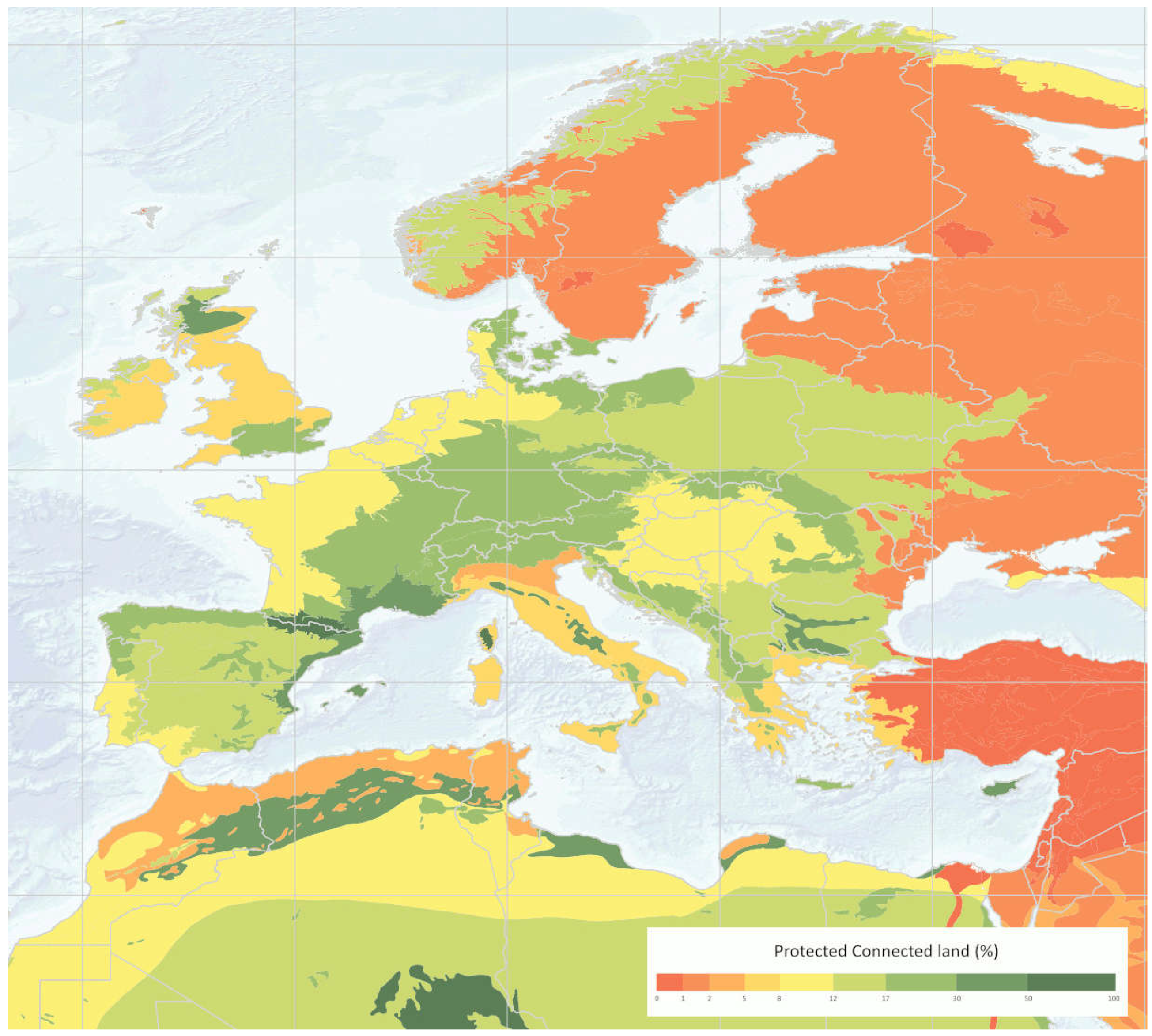
Figure 3.
Number of birds potentially threatened by renewable energy production (REP) in the EU. Source: JRC (2024).
Figure 3.
Number of birds potentially threatened by renewable energy production (REP) in the EU. Source: JRC (2024).
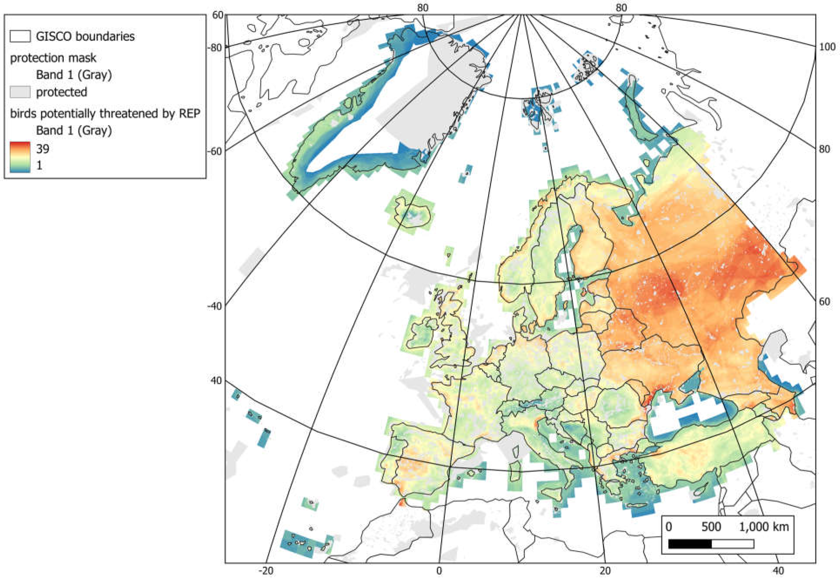

Table 1.
Inputs, tools, and outputs in the DOPA workflow. For a detailed workflow description see Supplementary data 1.
Table 1.
Inputs, tools, and outputs in the DOPA workflow. For a detailed workflow description see Supplementary data 1.
| Phase | Inputs | Tools | Outputs |
|---|---|---|---|
| Pre-processing |
Baseline datasets (=reporting levels) Administrative layers
|
PostGIS flattening scripts for multi-overlapping vectors. GRASS-GIS: Full workflow, organized as a series of scripts, for the estimation of Total Carbon Stocks as the sum of 5 different carbon 'pools'. The procedure is based on methodologies published in (Harris et al., 2021; IPCC, 2019) |
Pre-processed relational database that includes:
Five global carbon datasets :
|
|
Thematic datasets Conservation sites
Global landcover and carbon datasets | |||
| Processing | Pre-processing outputs + global thematic datasets |
Postgres SQL-only scripts for base protection coverages (country/land/marine/ecoregion/protection).
|
GLOBAL output tables Global raw intersections of base/thematic datasets (coverages cover the whole global surface) |
| Post-processing | Processing outputs |
|
Country/ecoregion/protected area indicator tables (i.e., standard DOPA outputs) On-demand aggregations (e.g., a specific reporting for a region or a site, a subset of species assessment, etc.) |
Table 2.
Examples of outputs on global, regional and national PAC indicators.
| Indicator relevant to KM-GBF and SDGs | Global | Regional – Europe | National – Italy |
|---|---|---|---|
| Terrestrial Protected Area Coverage | 21,295,150 km2 (14.45 %) | 1,086,134 km2 (26.23%) | 65,057 km2 (21.57 %) |
| Marine (EEZ) Protected Area Coverage | 29,245,536 km2 (8.06 %) |
654,856 km2 (11.21 %) | 57,452 km2 (10.71 %) |
| Ecoregions representation | Number of ecoregions with these coverages: 0-17%: 644 17-30%: 180 30-50%: 137 More than 50%: 136 |
Number of ecoregions with these coverages: 0-17%: 16 17-30%: 16 30-50%: 20 More than 50%: 16 |
Number of ecoregions with these coverages: 0-17: 4% 17-30%: 4 30-50%: 5 More than 50%: 2 |
| Protection of key biodiversity areas | KBA fully protected: 3278 KBA partially protected: 6780 KBA not protected: 5890 |
KBA fully protected: 1266 KBA partially protected: 1972 KBA not protected: 108 |
KBA fully protected: 41 KBA partially protected: 127 KBA not protected: 4 |
Disclaimer/Publisher’s Note: The statements, opinions and data contained in all publications are solely those of the individual author(s) and contributor(s) and not of MDPI and/or the editor(s). MDPI and/or the editor(s) disclaim responsibility for any injury to people or property resulting from any ideas, methods, instructions or products referred to in the content. |
© 2024 by the authors. Licensee MDPI, Basel, Switzerland. This article is an open access article distributed under the terms and conditions of the Creative Commons Attribution (CC BY) license (http://creativecommons.org/licenses/by/4.0/).
Copyright: This open access article is published under a Creative Commons CC BY 4.0 license, which permit the free download, distribution, and reuse, provided that the author and preprint are cited in any reuse.


