
Submitted:
06 August 2024
Posted:
07 August 2024
You are already at the latest version
Abstract
Mediterranean mountain landscapes feature pastoralism, and the maintenance of sheep and goat grazing is the main challenge for their sustainability. To deliver pastoralism ecosystem services, particularly in reducing fire risk amidst global change, it is essential to align the herds' size and impact with the current foraging status of the ecosystems in real time. This approach allows for more efficient herding, thereby maintaining the resilience of these landscapes. Understanding complex grazing processes at a landscape scale can now be aided by the various sensors and trackers available. The development of geolocation technologies makes it possible to combine information at different scales on time to adapt pastoralism more efficiently in the context of rural abandonment. In this paper, we analyze artificial intelligence-based IoT data from the daily routes of three flocks of goats and sheep over a year in the mountains of central Portugal. A principal components analysis of the temporal geolocalization of the herds discriminates the spatial scale of the territorial selection attributed to the herders and the animals, analytically confirming what has been described empirically by several authors. The results confirmed the relevance of these operational solutions for understanding complex landscape processes and efficiently supporting sustainable management. Finally, our result shows that these innovative tools are reliable for monitoring animal ecosystem services in Mediterranean mountain landscapes in support of policy decisions on their remuneration.
Keywords:
sheep and goats
; Montemuro
; GNSS
; grazing patterns
1. Introduction
Most Mediterranean mountains feature broad mosaics of natural and seminatural vegetation, preserved by local communities primarily through grazing and, in some regions, also by controlled burning [1,2]. The landscape pattern emerges from a judicious combination of grazing and burning processes, supporting cattle, sheep, and goat herds; they are the economic and social basis of an ancestral pastoralism culture on common rangelands [3,4,5]. Shepherds traditionally open their stables every morning to herd their flocks through an intricate mosaic of natural and seminatural vegetation patches - the grazing domain - until the end of the day when all animals’ forage needs must be fulfilled [6]. They rely on their acute perception of the landscape concerning every site’s vegetation condition and the herd’s reaction to the forage palatability and availability [7,8,9,10,11]. When necessary, they restore the vegetation’s palatability and structure by burning [12,13]. This spatiotemporal interaction between fire and pastoralism as determinants of landscape structure, composition, and dynamics is familiar to many other regions of the globe [14,15]. Such landscapes’ stability depends on the dynamics associated with (i) the grazing by ungulate herbivores of burned patches, thereby reducing their likelihood of burning in the future, and (ii) the eventual burning of fuels accumulated in ungrazed patches [12]. Based on generations of empirical knowledge, the pastoralists’ ability to patch up rangelands is essential to maintain grazing in these landscapes, which would otherwise be lost and threatened by wildfires. [16,17,18,19,20,21].
Many spatiotemporal decision scales determine the frequency, intensity and extent of the grazing process that manages these landscapes, from the herder’s scale of deciding how to use the rangeland throughout the year to the animal’s scale of choosing which plant to browse at any given moment, a continuum of shared decision scales operate between herder and herd [22,23].to the animal scale choosing which plant to browse each instant, a continuum of shared decision scales acts between herder and herd. It is necessary to analyze this scale continuum to establish their grain and extent and correctly interpret the grazing process. The daily grazing itinerary is the grain of analysis for the annual cycle of rural activities. On the other hand, this daily journey is also, in turn, the extent that integrates each instant and spot, the grain of the grazing process, into its place and time. For an analytical approach to the grazing path, it is necessary to integrate the composition and structure of vegetation over time and space each day and for the year.
Recent studies have expanded our understanding of these systems by integrating traditional knowledge with modern technologies. For example, Louhaichi et al. (2022) developed sustainable rangeland management toolkits that combine participatory approaches with advanced remote sensing techniques, enhancing our ability to monitor and manage these landscapes [24]. Mitri et al. (2022) explored methods for assessing the grazing behavior and intensity of small ruminants, highlighting the need for precise tracking and monitoring to optimize grazing patterns [25]. Furthermore, Giralt-Rueda and Santamaría (2023) emphasized the importance of landscape heterogeneity in stabilizing wild ungulate populations amidst climatic variability, providing valuable insights into managing grazing under changing environmental conditions [26].
Sharifian et al. (2023) reviewed the global principles underlying forage plant-livestock-herder interactions, underscoring the importance of integrating local traditional knowledge with scientific insights [27]. Additionally, Filippa et al. (2022) utilized remote sensing to evaluate the distribution and productivity of mountain grasslands, offering a modern perspective on traditional grazing areas [28]. Oikonomou et al. (2023) conducted a meta-analysis to assess the effectiveness of grazing as a management tool in Mediterranean pastures, emphasizing its role in enhancing rangeland value [29].
Monitoring pastured vegetation has experienced significant developments through advances in high-resolution remote sensing [30,31,32] and the Internet of Things technologies [33,34]. Unmanned Aerial Vehicles (UAV) with high-performance sensors can now accurately survey the vegetation structure and composition in space and time using multi- and hyperspectral sensors and radar and thermal technology [35,36,37]. Similarly, geolocation and data transmission devices, such as the new GNSS systems, GSM, LoRa, and satellite networks, are now widely available for tracing herds’ activities and displacements [38,39,40,41,42]. These technologies lead to new areas of data processing in landscape science, particularly in Artificial Intelligence and Big Data [43], to manage massive, precise, and extensive spatial and temporal data [44,45,46,47].
The new research resources will be crucial to mastering and transmitting empirical traditional local knowledge that until now has only been transferred from elder to youth, generation through generation [48,49,50]. That is the case in the northern Portuguese mountain range, which includes the Serra de Montemuro [51,52].
Considering the above premises and based on an approach that takes the daily herd itinerary as the basic unit of the grazing process, the main aim of this study is to contribute to assessing the synthesizing capacity of the principal components analysis of the spatiotemporal distribution of ruminants to monitor and model pastoralism in Mediterranean mountain rangelands. To this end, we developed and applied a framework with two procedures: (a) synthesize the grazing process based on the herd locations and (b) discriminate the grazing regimes of different Serra de Montemuro (Portugal) herders and pastoral domains.
2. Materials and Methods
We studied the journeys of three pastoralists based on the locations registered by GNSS collars mounted on their sheep and goats. Each set of positions from departure to return to the stable daily is a part of the annual grazing cycle. Therefore, considering the accuracy of the GNSS data, we used kernel density images for everyday journeys as the sampling unit.
2.1. Study Area and Herding Assessment at Montemuro Natura 2000, Portugal
The study is conducted at the Montemuro European Natura 2000 site (PTCON0025), covering 38,763 hectares in the central northern mountains of Portugal (Figure 1). This region experiences a climate that transitions from Temperate to Mediterranean, characterized by prolonged continental winters and brief, warm summers. The landscape varies in elevation from 400 to over 1,300 meters, with average annual temperatures between 8 and 13°C and annual precipitation ranging from 1,800 to 2,700 millimeters. The research examines explicitly the rangelands utilized by two goat herds and one sheep flock. Each pastoralist daily drives their animals within a 3-kilometre radius of their stable, returning each evening. The terrain, primarily communal land, consists of a patchwork of Ericaceae and Cystaceae shrublands interspersed with small grassland areas, shaped by the interplay of relief, topography, grazing and trampling, prescribed burns, and the impact of wildfires.
2.2. GNSS Collar Tracking and Data Refinement for Grazing Analysis
We equipped one animal from each herd with a GNSS device, programmed to record its position at a minimum interval of five minutes and only when it moved. This approach, which balances battery autonomy and tracking detail, was supported in our team’s previous research [53]. We utilized collars with GPS functionality and GLOBALSTAR communication capabilities (DMS SAT, DOMODIS, Navarra, Spain), powered by 3.7-volt lithium-ion batteries with a capacity of 7.8 Ah. The device’s dimensions are 115 mm in length, 65 mm in width, and 40 mm in height, and it weighs 750 grams, less than 1.5% of the animal’s body weight. The animals adapted well to wearing the devices, and the pastoralists observed no alterations in their behavior. The battery life of the collars lasted approximately two months, requiring recharging by the pastoralists, during which some tracking data might be lost temporarily. The DOMODIS web platform provided position coordinates to five decimal places in degrees, offering a precision of approximately 84 centimeters in longitude and 111 centimeters in latitude at the latitudes studied.
Throughout 2022, positions were recorded from January 17, when the collars were attached, to December 22, when grazing activity typically declines due to the Christmas period. Using QGIS GIS software, we refined the data in three phases to ensure accuracy: First, we removed any data points indicating an improbable movement of over 1000 meters within five minutes, as such speed is unattainable for these animals. Next, we discarded any positions erroneously recorded inside the barn during non-grazing hours or at night, likely due to the barn’s deteriorated walls and roof permitting satellite signals to penetrate. Lastly, we excluded any daily records that contained fewer than 20 positions, as these were deemed inadequate for representing a whole grazing route (Table 1).
2.3. Mapping and Analyzing Grazing Patterns via Heatmaps and PCA
As described, our methodology considers each day’s grazing route as a distinct segment within the broader annual rangeland usage cycle. We utilized the QGIS GIS Heatmap module to map daily grazing densities, setting the pixel resolution at 10 meters. Using kernel density maps allowed us to calculate the number of recorded positions within a 150-meter radius for each grazing day. This combination of pixel size and evaluation radius was chosen because it demonstrated the most significant variation/entropy in a prior analysis of the most extended itinerary (one with the most recorded positions). Before settling on this configuration, we experimented with pixel sizes ranging from 2 to 30 meters and radii from 60 to 500 meters. (Castro, in prep).
Based on the 2022 collar positions of the three herds, we generated 945 grazing intensity images depicting how the three herds utilize the different grazing ranges (Table 2). We performed a Principal Component Analysis [54] using a phyton script on the Google Colab platform to synthesize their spatiotemporal variation. In our study, we applied Principal Component Analysis (PCA) to the daily heatmaps dataset, each representing the spatial distribution of grazing pressure exerted by a herd over its rangeland.
The study employs Principal Component Analysis (PCA) to investigate daily heatmaps, which depict the spatial distribution of grazing pressure exerted by a herd across a rangeland. The analysis includes the following key components:
- PCA Objects: Each daily heatmap is considered an individual data point or observation in the PCA framework, representing a specific day’s grazing activity.
- PCA Variables: The pixels in the heatmaps are treated as variables, with each pixel indicating the grazing pressure at a particular spatial location on the rangeland.
- PCA Scores: These scores denote the projections of the original data points (daily heatmaps) onto the principal components. They encapsulate the daily variations in grazing pressure throughout the year, offering a simplified representation of complex patterns.
- PCA Loadings: The loadings reveal how much each pixel contributes to the principal components. They provide information on the direction and magnitude of each pixel’s impact, thereby identifying which rangeland areas are most influential in shaping the principal components.
This PCA-based analysis is instrumental in uncovering primary patterns in grazing behavior and pinpointing critical spatial regions that significantly influence these patterns. By reducing the data’s dimensionality, PCA facilitates the visualization and interpretation of intricate spatial and temporal variations in grazing pressure.
This technique enabled us to reduce the dimensionality of our data, with the PCA Loadings capturing the most significant patterns of variability in grazing activity through a series of "eigenmaps". These eigenmaps effectively highlighted vital areas and temporal grazing patterns, facilitating the identification of regular and anomalous grazing behaviors. By analyzing the PCA Scores together with the PCA Loadings, we could discern underlying grazing patterns, detect anomalies, and assess temporal changes, providing a robust basis for effectively evaluating and managing grazing dynamics in the studied area.
The new eigenmaps pretend to differentiate between the scales of decisions made by the herder and the animals. The herder’s decisions were reflected in the overall travel routes to various grazing patches, indicating broader management strategies. In contrast, the animals’ movements within these patches provided insights into more granular grazing behaviors, such as preferences for specific vegetation types or areas within the patch. This dual-scale approach allowed us to identify distinct patterns in grazing activity and offered a comprehensive understanding of the spatiotemporal dynamics at play. The findings can inform targeted management practices, such as optimizing grazing schedules and improving pasture utilization, ultimately enhancing sustainable rangeland management in the region.
3. Results
3.1. GPS Tracking Analysis: Rangeland Utilization by Sheep and Goat Herds
In 2022, between January 17 and December 22, the platform recorded 92,654 positions that, after the spatial, timing, and journey outliers cleaning, resulted in 71,403 analyzed positions (Table 2). Out of 338 possible rangeland journeys, goat B herd recorded 325 (96%) valid itineraries for analysis, goat D recorded 312 (92%), and sheep J recorded 308 (91%). The biggest failures in registering the journeys occurred in October for the goat B herd, with seven journeys lost, in November for goat herd D, with eight journeys lost, and in the sheep J herd, with ten journeys lost (figure 2).
Sheep J herd has the longest rangeland daily journeys, from 4h00 to 23h00 in summer. Due to their susceptibility to high temperatures, they must rest midway through the journey. On June 27, it recorded 139 locations, meaning rangeland daily journeys for more than 11 hours. The amplitude of goat herds’ rangeland journeys has never shown such a high seasonal variation (Figure 2).
Considering the 10-meter pixel resolution and the 150-meter search radius, we observed the highest density of GNSS records in the sheep J rangeland, reaching 191 records per hectare. After adjusting for 30 lost journey recordings, this density suggests that, on average, 150 sheep actively grazed this hectare for more than 18 hours throughout 2022.
3.2. Rangeland Journeys Principal Components Analysis
The PCA eigenvalues from the rangeland journeys heatmaps indicate greater regularity in the daily routes of the sheep flock, with half of the variance explained by the sixth component. In contrast, goats require more components to reach a similar level of explanation—twice as many for goat herd B and three times as many for goat herd D (Figure 3). Additionally, when examining the diversity of routes, the sheep J herd encompasses 88.4% of the variance with just the first 10% of the components (31). In contrast, goat herds show lower accumulations, with 72.2% for herd B (33 components) and 61.6% for herd D (31 components).
Figure 4, Figure 5 and Figure 6 present a detailed analysis of the PCA scores and loadings for three distinct principal components of each herd, offering a comparative view of grazing patterns between sheep and goat herds:
- First Principal Component.
- 50% of Accumulating Explained Variance Component.
- 80% of Accumulating Explained Variance Component.
The PCA Scores (upper plots) vary considerably across successive days throughout the year. This daily variability reflects the dynamic nature of grazing patterns and highlights herd behavior and movement changes. As the principal components become less representative, the amplitude of variability in the scores decreases, indicating that these components contribute less to the overall patterns of grazing pressure.
The PCA Loadings ("eigenmaps" below) represent how each pixel (variable) contributes to the principal components. The contours include all pixels with a kernel density greater than zero, corresponding to the GNSS locations of the monitored animals within a 150 m search radius. These loadings reveal a transition from smooth patterns in the first components, indicative of broader spatial decisions, to rough patterns in the later components, which reflect more localized, detailed choices.
The spatial patterns observed in the PCA loadings could be interpreted as representing different scales of decision-making. The smooth patterns in the first principal components suggest decisions made at a broader scale, such as the selection of travel routes to grazing areas or general movements across the rangeland. The herder’s overarching strategy influences these patterns in managing the herd’s grazing activity.
In contrast, the rougher patterns in the later principal components correspond to finer-scale decisions, such as the herd’s specific movements within a grazing patch. These patterns reflect the herds’ more detailed, day-to-day interactions with the landscape, influenced by factors such as forage availability, terrain, and other environmental conditions.
This differentiation in spatial scales is crucial for understanding the complex dynamics of grazing behavior and management. It highlights how herders and animals interact with the landscape at different levels, from broad, strategic movements to detailed, localized actions. The analysis reveals that sheep herds concentrate variance in the first principal components, suggesting a more homogeneous and focused rangeland use. This trend contrasts with goat herds, which display more complex patterns, indicating a more diverse and possibly opportunistic use of the grazing resources.
Furthermore, these findings have practical implications for rangeland management. Understanding the scales at which decisions are made can help design management practices that align with the natural behaviors of the herds. For instance, recognizing the broader decision scales could inform the placement of water points or supplemental feeding areas, while understanding finer-scale movements could aid in habitat restoration efforts or the protection of sensitive regions.
Overall, the PCA analysis provides a valuable framework for visualizing and interpreting the intricate patterns of grazing pressure, offering insights into herd behaviour’s spatial and temporal dynamics. This comprehensive understanding is essential for sustainable rangeland management and the effective allocation of resources in pastoral systems.
4. Discussion
Our experiment monitored the spatial and temporal grazing patterns of two goat herds and one sheep herd in the Serra de Montemuro, central Portugal, using IoT technologies over one year. The GNSS collars, placed on a representative animal from each herd, recorded location data at five-minute intervals, allowing us to detect high-resolution grazing patterns at the landscape scale. We faced challenges related to the technology’s dependency on favorable satellite constellations [55,56,57,58] and the importance of thorough data cleaning to remove outliers and errors, such as locations outside the grazing areas or recorded during non-grazing hours [59,60,61]. While the temporal resolution of GNSS datasets is high, ensuring consistent temporal coverage and addressing potential gaps, such as those caused by battery replacements, is crucial for accurate interpretations [33,62]. Despite these challenges, our study demonstrated GNSS data’s potential to refine grazing pattern analyses [63,64].
Our analysis revealed a tendency for herders’ decisions to influence the distribution of GNSS records across the landscape, while the persistence of records at specific sites reflected the herd’s preferences (Figure 7) [65,66]. This preference was evident from the canonical patterns of landscape use that we identified, showing a clear distinction between broader-scale decisions made by the herders and the finer-scale movements of the animals within grazing patches. The first components of the PCA, representing smoother patterns, correspond to the herders’ decision scale, such as selecting travel routes. In contrast, the later components, with rougher patterns, reflect the herd’s scale choice, such as individual animals’ movements within the grazing patches. This differentiation highlights the complex dynamics of grazing behavior and management [67,68].
Our study also emphasized the importance of not taking a "black-box" approach to analyzing GNSS data. The broader-scale PCA components, which reflect smoother patterns, should be contrasted with herders’ traditional knowledge obtained through field interviews. This comparison helps validate the data and provides context for understanding herder decision-making processes, such as selecting travel routes and grazing areas. Conversely, the finer-scale PCA components, characterized by rougher patterns, need to be further related to the preferences of the animals. These preferences can be achieved by integrating spatial and seasonal remote sensing data on vegetation productivity, which offers insights into the animals’ selection of specific patches based on the forage availability and quality [69,70,71]. Although IoT data provided valuable insights, it had limitations, particularly in detecting vegetation conditions not immediately apparent at the landscape level. Nonetheless, the behavioral patterns captured through GNSS were consistent with the observed practices of herders, suggesting high reliability in the data collected [72,73,74].
Future research should further explore the integration of technologies to enhance the interpretation of GNSS data and provide a more comprehensive understanding of grazing dynamics. Integrating thermal imaging from UAVs could allow for better refinement of the search radius when estimating the kernel density of GNSS locations recorded by the collar. By assessing the distribution of the herd around the monitored animal, thermal imaging can provide a more accurate representation of the group’s spatial arrangement and density, leading to more precise kernel density estimates [75]. This enhancement helps distinguish the broader-scale decisions of herders from the finer-scale preferences of the animals, thereby improving the overall analysis of grazing patterns. This approach could uncover more subtle vegetation changes and improve the management of grazing areas. Moreover, the distinction between the broader-scale decisions of herders and the finer-scale preferences of the animals should be further investigated to understand the socio-ecological roles of these actors better.
Our findings underscore the importance of exploring the relationships between GNSS data and factors like vegetation patterns and herder decisions. This research could inform better policymaking by highlighting the socio-ecological contributions of pastoralists in managing Iberian Mountain landscapes. Such insights are vital for supporting sustainable development goals, particularly in promoting health and well-being, responsible production and consumption, climate change mitigation, and the preservation of terrestrial ecosystems. Applying IoT-based methods in small ruminant pastoralism holds significant potential for adapting traditional practices to contemporary environmental and societal needs.
Author Contributions
All authors contributed to the study’s conception and design. José Castro and Marina Castro performed material preparation and data collection; Eduardo Castro and José Castro performed data analysis. José Castro wrote the first draft of the manuscript, and all authors commented on previous versions. All authors read and approved the final manuscript.
Funding
The authors are grateful to the Foundation for Science and Technology (FCT, Portugal) for financial support through national funds FCT/MCTES (PIDDAC) to CIMO (UIDB/00690/2020 and UIDP/00690/2020) and SusTEC (LA/P/0007/2020). Also, E.C. was funded by FCT - Foundation for Science and Technology, within the PhD grant SFRH/BD/136274/2018.
Data Availability Statement
The datasets generated and/or analyzed during the used and/or analyzed during the current study are available from the corresponding author upon reasonable request.
Acknowledgements
The authors are grateful for Manuel Rainha’s friendship; he has challenged and supported our commitment to the ecology of the Montemuro Pastoral Landscape. The authors would also like to thank our colleagues João Paulo Castro, José Lopes, and the shepherds of the Serra de Montemuro, who have taught us every day all the secrets of pastoralism that is as pleasant as sustainable.
Conflicts of Interest
The authors declare no conflicts of interest.
References
- Perevolotsky, A.; Seligman, N.G. Role of Grazing in Mediterranean Rangeland Ecosystems. Bioscience 1998, 48, 1007–1017. [CrossRef]
- Naveh, Z.; Goldammer, J.G.; Jenkins, M.J. Fire in the Mediterranean-a Landscape Ecological Perspective. Transdisciplinary Challenges in Landscape Ecology and Restoration Ecology 1990. [CrossRef]
- Blondel, J. The ’Design’ of Mediterranean Landscapes: A Millennial Story of Humans and Ecological Systems during the Historic Period. Hum Ecol 2006, 34, 713–729. [CrossRef]
- Topalidou, E.; Solomou, A.D.; Santos, S.S.; Krystallidou, E.; Kakara, S.; Mantzanas, K. Dynamic Role and Importance of Multi-Kingdom Communities in Mediterranean Wood-Pastures. Sustainability 2021, Vol. 13, Page 10179 2021, 13, 10179. [CrossRef]
- Velado-Alonso, E.; Morales-Castilla, I.; Gómez-Sal, A. The Landscapes of Livestock Diversity: Grazing Local Breeds as a Proxy for Domesticated Species Adaptation to the Environment. Landsc Ecol 2022, 37, 1035–1048. [CrossRef]
- Castro, J.; Castro, M.; Gómez-Sal, A. Changes on the Climatic Edge: Adaptation of and Challenges to Pastoralism in Montesinho (Northern Portugal). Mt Res Dev 2021, 41. [CrossRef]
- Baumont, R.; Prache, S.; Meuret, M.; Morand-Fehr, P. How Forage Characteristics Influence Behaviour and Intake in Small Ruminants: A Review. Livest Prod Sci 2000, 64, 15–28. [CrossRef]
- Meuret, M.; Provenza, F.D. When Art and Science Meet: Integrating Knowledge of French Herders with Science of Foraging Behavior. Rangel Ecol Manag 2015, 68, 1–17. [CrossRef]
- Bailey, D.W.; Stephenson, M.B.; Pittarello, M. Effect of Terrain Heterogeneity on Feeding Site Selection and Livestock Movement Patterns. Anim Prod Sci 2015, 55, 298–308. [CrossRef]
- Coppolillo, P.B. The Landscape Ecology of Pastoral Herding: Spatial Analysis of Land Use and Livestock Production in East Africa. Hum Ecol 2000, 28, 527–560. [CrossRef]
- Turner, M.D.; Hiernaux, P. The Use of Herders’ Accounts to Map Livestock Activities across Agropastoral Landscapes in Semi-Arid Africa. Landscape Ecology 2002 17:5 2002, 17, 367–385. [CrossRef]
- Fuhlendorf, S.D.; Engle, D.M.; Kerby, J.; Hamilton, R. Pyric Herbivory: Rewilding Landscapes through the Recoupling of Fire and Grazing. Conservation Biology 2009, 23, 588–598. [CrossRef]
- McLauchlan, K.K.; Higuera, P.E.; Miesel, J.; Rogers, B.M.; Schweitzer, J.; Shuman, J.K.; Tepley, A.J.; Varner, J.M.; Veblen, T.T.; Adalsteinsson, S.A.; et al. Fire as a Fundamental Ecological Process: Research Advances and Frontiers. Journal of Ecology 2020, 108, 2047–2069. [CrossRef]
- McGranahan, D.A.; Engle, D.M.; Fuhlendorf, S.D.; Winter, S.J.; Miller, J.R.; Debinski, D.M. Spatial Heterogeneity across Five Rangelands Managed with Pyric-Herbivory. Journal of Applied Ecology 2012, 49, 903–910. [CrossRef]
- Archibald, S.; Bond, W.J.; Stock, W.D.; Fairbanks, D.H.K. SHAPING THE LANDSCAPE: FIRE–GRAZER INTERACTIONS IN AN AFRICAN SAVANNA. Ecological Applications 2005, 15, 96–109. [CrossRef]
- García-Ruiz, J.; Nadal-Romero, E.; Geomorphology, N.L.-R.-; 2013, undefined Erosion in Mediterranean Landscapes: Changes and Future Challenges. Elsevier 1992, 45, 436–440. [CrossRef]
- Köchy, M.; Mathaj, M.; Jeltsch, F.; Malkinson, D. Resilience of Stocking Capacity to Changing Climate in Arid to Mediterranean Landscapes. Reg Environ Change 2008, 8, 73–87. [CrossRef]
- Mouillot, F.; Ratte, J.P.; Joffre, R.; Moreno, J.M.; Rambal, S. Some Determinants of the Spatio-Temporal Fire Cycle in a Mediterranean Landscape (Corsica, France). Landsc Ecol 2003, 18, 665–674. [CrossRef]
- Varela, E.; Pulido, F.; Moreno, G.; Zavala, M. Targeted Policy Proposals for Managing Spontaneous Forest Expansion in the Mediterranean. Journal of Applied Ecology 2020, 57, 2373–2380. [CrossRef]
- Torres-Manso, F.; Marta-Costa, A.; Castro, M.; Agroforestry, L.T.-; 2017, undefined Silvopastoral Systems as a Tool for Territorial Sustainability and Biodiversity. Springer 2018, 317–333. [CrossRef]
- Liao, C.; Agrawal, A.; Clark, P.E.; Levin, S.A.; Rubenstein, D.I. Landscape Sustainability Science in the Drylands: Mobility, Rangelands and Livelihoods. Landsc Ecol 2020, 35, 2433–2447. [CrossRef]
- Molnár, Z. Perception and Management of Spatio-Temporal Pasture Heterogeneity by Hungarian Herders. Rangel Ecol Manag 2014, 67, 107–118. [CrossRef]
- Kis, J.; Barta, S.; Elekes, L.; Engi, L.; … T.F.-K. our lands; 2017, undefined Traditional Herders’ Knowledge and Worldview and Their Role in Managing Biodiversity and Ecosystem-Services of Extensive Pastures. books.google.com 2017.
- Louhaichi, M.; Davies, J.; Gamoun, M.; Hassan, S.; Abu-Zanat, M.; Neffati, M.; Tadros, M.; Ouled Belgacem, A.; Rajabov, T.; Annouri, L. Sustainable Rangeland Management Toolkit for Resilient Pastoral Systems. 2022.
- Mitri, G.; Gebrael, K.; Nasrallah, G.; Nassar, M.B.; Masri, N.; Choueiter, D.; Kyriazopoulos, A.P. Assessing Grazing Behavior and Intensity of Small Ruminants in a Mediterranean Rangeland. Livestock Research for Rural Development 2022, 34.
- Giralt-Rueda, J.M.; Santamaría, L. Landscape Heterogeneity Increases the Stability of Wild Ungulate Populations Facing Climatic Variability in Mediterranean Ecosystems. Science of the Total Environment 2023, 894, 164826. [CrossRef]
- Sharifian, A.; Gantuya, B.; Wario, H.T.; Kotowski, M.A.; Barani, H.; Manzano, P.; Krätli, S.; Babai, D.; Biró, M.; Sáfián, L. Global Principles in Local Traditional Knowledge: A Review of Forage Plant-Livestock-Herder Interactions. J Environ Manage 2023, 328, 116966. [CrossRef]
- Filippa, G.; Cremonese, E.; Galvagno, M.; Bayle, A.; Choler, P.; Bassignana, M.; Piccot, A.; Poggio, L.; Oddi, L.; Gascoin, S. On the Distribution and Productivity of Mountain Grasslands in the Gran Paradiso National Park, NW Italy: A Remote Sensing Approach. International Journal of Applied Earth Observation and Geoinformation 2022, 108, 102718. [CrossRef]
- Oikonomou, D.; Vrahnakis, M.; Yiakoulaki, M.; Xanthopoulos, G.; Kazoglou, Y. Grazing as a Management Tool in Mediterranean Pastures: A Meta-Analysis Based on A Literature Review. Land (Basel) 2023, 12, 1290. [CrossRef]
- Frantz, D.; Hostert, P.; Rufin, P.; Ernst, S.; Röder, A.; van der Linden, S. Revisiting the Past: Replicability of a Historic Long-Term Vegetation Dynamics Assessment in the Era of Big Data Analytics. Remote Sens (Basel) 2022, 14, 597. [CrossRef]
- Castro, M.; Ameray, A.; Castro, J.P. A New Approach to Quantify Grazing Pressure under Mediterranean Pastoral Systems Using GIS and Remote Sensing. Int J Remote Sens 2020, 41, 5371–5387. [CrossRef]
- Handcock, R.; Swain, D.; Bishop-Hurley, G.; Patison, K.; Wark, T.; Valencia, P.; Corke, P.; O’Neill, C. Monitoring Animal Behaviour and Environmental Interactions Using Wireless Sensor Networks, GPS Collars and Satellite Remote Sensing. Sensors 2009, 9, 3586–3603. [CrossRef]
- Aquilani, C.; Confessore, A.; Bozzi, R.; Sirtori, F.; Pugliese, C. Review: Precision Livestock Farming Technologies in Pasture-Based Livestock Systems. Animal 2022, 16, 100429. [CrossRef]
- Riaboff, L.; Shalloo, L.; Smeaton, A.F.; Couvreur, S.; Madouasse, A.; Keane, M.T. Predicting Livestock Behaviour Using Accelerometers: A Systematic Review of Processing Techniques for Ruminant Behaviour Prediction from Raw Accelerometer Data. Comput Electron Agric 2022, 192, 106610. [CrossRef]
- Colomina, I.; Molina, P. Unmanned Aerial Systems for Photogrammetry and Remote Sensing: A Review. ISPRS Journal of Photogrammetry and Remote Sensing 2014, 92, 79–97. [CrossRef]
- Pádua, L.; Vanko, J.; Hruška, J.; Adão, T.; Sousa, J.J.; Peres, E.; Morais, R. UAS, Sensors, and Data Processing in Agroforestry: A Review towards Practical Applications. Int J Remote Sens 2017, 38, 2349–2391. [CrossRef]
- Michez, A.; Lejeune, P.; Bauwens, S.; Herinaina, A.; Blaise, Y.; Castro Muñoz, E.; Lebeau, F.; Bindelle, J. Mapping and Monitoring of Biomass and Grazing in Pasture with an Unmanned Aerial System. Remote Sens (Basel) 2019, 11, 473. [CrossRef]
- Dobos, R.C.; Taylor, D.B.; Trotter, M.G.; McCorkell, B.E.; Schneider, D.A.; Hinch, G.N. Characterising Activities of Free-Ranging Merino Ewes before, during and after Lambing from GNSS Data. Small Ruminant Research 2015, 131, 12–16. [CrossRef]
- Fogarty, E.S.; Manning, J.K.; Trotter, M.G.; Schneider, D.A.; Thomson, P.C.; Bush, R.D.; Cronin, G.M. GNSS Technology and Its Application for Improved Reproductive Management in Extensive Sheep Systems. Anim Prod Sci 2015, 55, 1272. [CrossRef]
- Plaza, J.; Palacios, C.; Sánchez-García, M.; Criado, M.; Nieto, J.; Sánchez, N. Monitoring spatial behavior of pastoralist sheep through gps, lidar data and vnir image. The International Archives of the Photogrammetry, Remote Sensing and Spatial Information Sciences 2020, XLIII-B4-2020, 169–175. [CrossRef]
- Ares, J.O.; Dignani, J.; Bertiller, M.B. Cost Analysis of Remotely Sensed Foraging Paths in Patchy Landscapes with Plant Anti-Herbivore Defenses (Patagonia, Argentina). Landsc Ecol 2007, 22, 1291–1301. [CrossRef]
- Ungar, E.D.; Henkin, Z.; Gutman, M.; Dolev, A.; Genizi, A.; Ganskopp, D. Inference of Animal Activity From GPS Collar Data on Free-Ranging Cattle. Rangel Ecol Manag 2005, 58, 256–266. [CrossRef]
- Kleanthous, N.; Hussain, A.J.; Khan, W.; Sneddon, J.; Al-Shamma’a, A.; Liatsis, P. A Survey of Machine Learning Approaches in Animal Behaviour. Neurocomputing 2022, 491, 442–463. [CrossRef]
- LaDeau, S.L.; Han, B.A.; Rosi-Marshall, E.J.; Weathers, K.C. The Next Decade of Big Data in Ecosystem Science. Ecosystems 2017, 20, 274–283. [CrossRef]
- Stupariu, M.-S.; Cushman, S.A.; Pleşoianu, A.-I.; Pătru-Stupariu, I.; Fürst, C. Machine Learning in Landscape Ecological Analysis: A Review of Recent Approaches. Landsc Ecol 2022, 37, 1227–1250. [CrossRef]
- Koppes, M.; King, L. Beyond x,y,z(t); Navigating New Landscapes of Science in the Science of Landscapes. J Geophys Res Earth Surf 2020, 125. [CrossRef]
- Reichstein, M.; Camps-Valls, G.; Stevens, B.; Jung, M.; Denzler, J.; Carvalhais, N.; Prabhat Deep Learning and Process Understanding for Data-Driven Earth System Science. Nature 2019, 566, 195–204. [CrossRef]
- Brodnig, G.; Mayer-Schönberger, V. Bridging the Gap: The Role of Spatial Information Technologies in the Integration of Traditional Environmental Knowledge and Western Science. The Electronic Journal of Information Systems in Developing Countries 2000, 1, 1–15. [CrossRef]
- McBride, B.B.; Sanchez-Trigueros, F.; Carver, S.J.; Watson, A.E.; Stumpff, L.M.; Matt, R.; Borrie, W.T. Participatory Geographic Information Systems as an Organizational Platform for the Integration of Traditional and Scientific Knowledge in Contemporary Fire and Fuels Management. J For 2017, 115, 43–50. [CrossRef]
- Raymond, C.M.; Fazey, I.; Reed, M.S.; Stringer, L.C.; Robinson, G.M.; Evely, A.C. Integrating Local and Scientific Knowledge for Environmental Management. J Environ Manage 2010, 91, 1766–1777. [CrossRef]
- Marta-Costa, A.; Pinto, R.; Torres Manso, F.; Tibério, M.L.; Carneiro, I.; Portela, J. Involving Stakeholders in Forest Management: The Case of Montemuro Mountain Site. Regional Science Inquiry 2014, 6.
- Vieira, A.A.B. Serra de Montemuro : Dinâmicas Geomorfológicas, Evolução Da Paisagem e Património Natural. Douroramento, Universidade de Coimbra: Coimbra, 2009.
- Castro, J.; Godoy, L.; Castro, J.; Castro, M. Sheep Grazing Patterns for Better Land Management: Adjusting GPS Tracking Protocol. International Grassland Congress Proceedings 2022.
- Jolliffe, I.T. Principal Component Analysis for Special Types of Data; Springer, 2002;
- Bajaj, R.; Ranaweera, S.L.; Agrawal, D.P. GPS: Location-Tracking Technology. Computer (Long Beach Calif) 2008, 35. [CrossRef]
- Buerkert, A.; Schlecht, E. Performance of Three GPS Collars to Monitor Goats’ Grazing Itineraries on Mountain Pastures. Comput Electron Agric 2009, 65, 85–92. [CrossRef]
- Damani, A.; Shah, H.; Shah, K.; Vala, M. Global Positioning System for Object Tracking. Int J Comput Appl 2015, 109. [CrossRef]
- Hasan, H.S.; Hussein, M.; Saad, S.M.; Dzahir, M.A.M. An Overview of Local Positioning System: Technologies, Techniques and Applications. International Journal of Engineering and Technology(UAE) 2018, 7. [CrossRef]
- Callau, A.À.; Pérez-Albert, Y.; Giné, D.S. Quality of Gnss Traces from Vgi: A Data Cleaning Method Based on Activity Type and User Experience. ISPRS Int J Geoinf 2020, 9. [CrossRef]
- Prabha, R.; Kabadi, M.G. A Comprehensive Insight towards Pre-Processing Methodologies Applied on GPS Data. International Journal of Electrical and Computer Engineering 2020, 10. [CrossRef]
- Abbruzzo, A.; Ferrante, M.; De Cantis, S. A Pre-Processing and Network Analysis of GPS Tracking Data. Spat Econ Anal 2021, 16. [CrossRef]
- Fan, X.; Xuan, C.; Zhang, M.; Ma, Y.; Meng, Y. Estimation of Spatial-Temporal Distribution of Grazing Intensity Based on Sheep Trajectory Data. Sensors 2022, 22, 1469. [CrossRef]
- Gautam, B.; Rokaha, B.; Bhattarai, K. Enhancement of Traditional Knowledge with Modern Mind: A Case Study of Aamako Janto an Echo Friendly Agro-Device in IoOT (Internet of Old Things); 2018;
- Longo, D.; Boeri, A.; Turillazzi, B.; Orlandi, S. Cultural Heritage and Interoperable Open Platforms: Strategies for Knowledge, Accessibility, Enhancement and Networking. WIT Transactions on Ecology and the Environment 2020, 241. [CrossRef]
- Sheth, F.; Benke, K.K.; Kealy, A.; Rabian, A.H.; Raeside, M.; Waters, E.K.; Hamilton, A.J. Investigation of Feeding Preferences of GPS Monitored Sheep in a Binary Choice Experimental Design under Conditions of Spatial Uncertainty. 2015, 61, 173–184. [CrossRef]
- Kalenga Tshingomba, U.; Djibo, B.; Sautot, L.; Teisseire, M.; Jouven, M. A Spatialised Information System to Support Decisions Regarding Grazing Management in Mountainous and Mediterranean Rangelands. Comput Electron Agric 2022, 198. [CrossRef]
- Castro, J.; Castro, M.; Gómez-Sal, A. Changes on the Climatic Edge: Adaptation of and Challenges to Pastoralism in Montesinho (Northern Portugal). Mt Res Dev 2021, 41. [CrossRef]
- Sa Rego, J.; Cabo, P.; Castro, M. Pastoralism, Multifunctionality, and Environmental Agency: Insights from Mountain Sheep Pastoralists in Northern Portugal. Journal of Agrarian Change 2022, 22. [CrossRef]
- Bruggeman, J.E.; Garrott, R.A.; White, P.J.; Watson, F.G.R.; Wallen, R. COVARIATES AFFECTING SPATIAL VARIABILITY IN BISON TRAVEL BEHAVIOR IN YELLOWSTONE NATIONAL PARK. Ecological Applications 2007, 17, 1411–1423. [CrossRef]
- Coughenour, M.B. Spatial Components of Plant-Herbivore Interactions in Pastoral, Ranching, and Native Ungulate Ecosystems. Rangeland Ecology & Management/Journal of Range Management Archives 1991, 44, 530–542.
- Raynor, E.J.; Gersie, S.P.; Stephenson, M.B.; Clark, P.E.; Spiegal, S.A.; Boughton, R.K.; Bailey, D.W.; Cibils, A.; Smith, B.W.; Derner, J.D. Cattle Grazing Distribution Patterns Related to Topography across Diverse Rangeland Ecosystems of North America. Rangel Ecol Manag 2021, 75, 91–103. [CrossRef]
- Philo, J.; Hidekazu, O.; Yong, W.; Margaret, M.; Peh, L.S.; Rubenstein, D. Energy-Efficient Computing for Wildlife Tracking: Design Tradeoffs and Early Experiences with ZebraNet. In Proceedings of the Operating Systems Review (ACM); 2002; Vol. 36. [CrossRef]
- Ayele, E.D.; Meratnia, N.; Havinga, P.J.M. Towards a New Opportunistic Iot Network Architecture for Wildlife Monitoring System. In Proceedings of the 2018 9th IFIP International Conference on New Technologies, Mobility and Security, NTMS 2018 - Proceedings; 2018; Vol. 2018-January. [CrossRef]
- Barlow, S.E.; O’Neill, M.A. Technological Advances in Field Studies of Pollinator Ecology and the Future of E-Ecology. Curr Opin Insect Sci 2020, 38, 15–25. [CrossRef]
- Leira, F.S.; Helgesen, H.H.; Johansen, T.A.; Fossen, T.I. Object Detection, Recognition, and Tracking from UAVs Using a Thermal Camera. J Field Robot 2021, 38. [CrossRef]
Figure 1.
Study area on Montemuro Natura 2000 site.
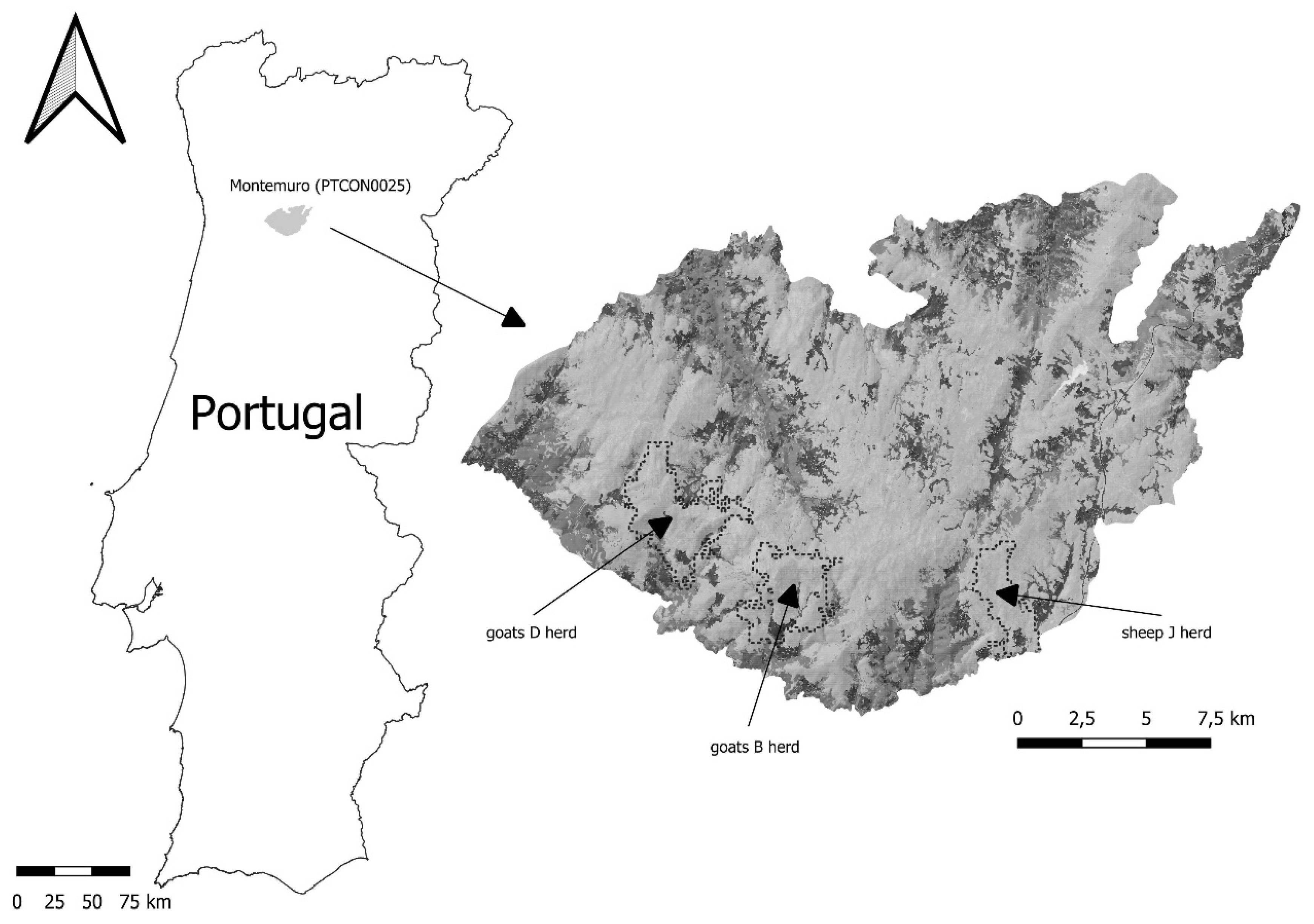
Figure 2.
Locations records on the date (X) and time (Y) throughout 2022 for the three experimental herds.
Figure 2.
Locations records on the date (X) and time (Y) throughout 2022 for the three experimental herds.
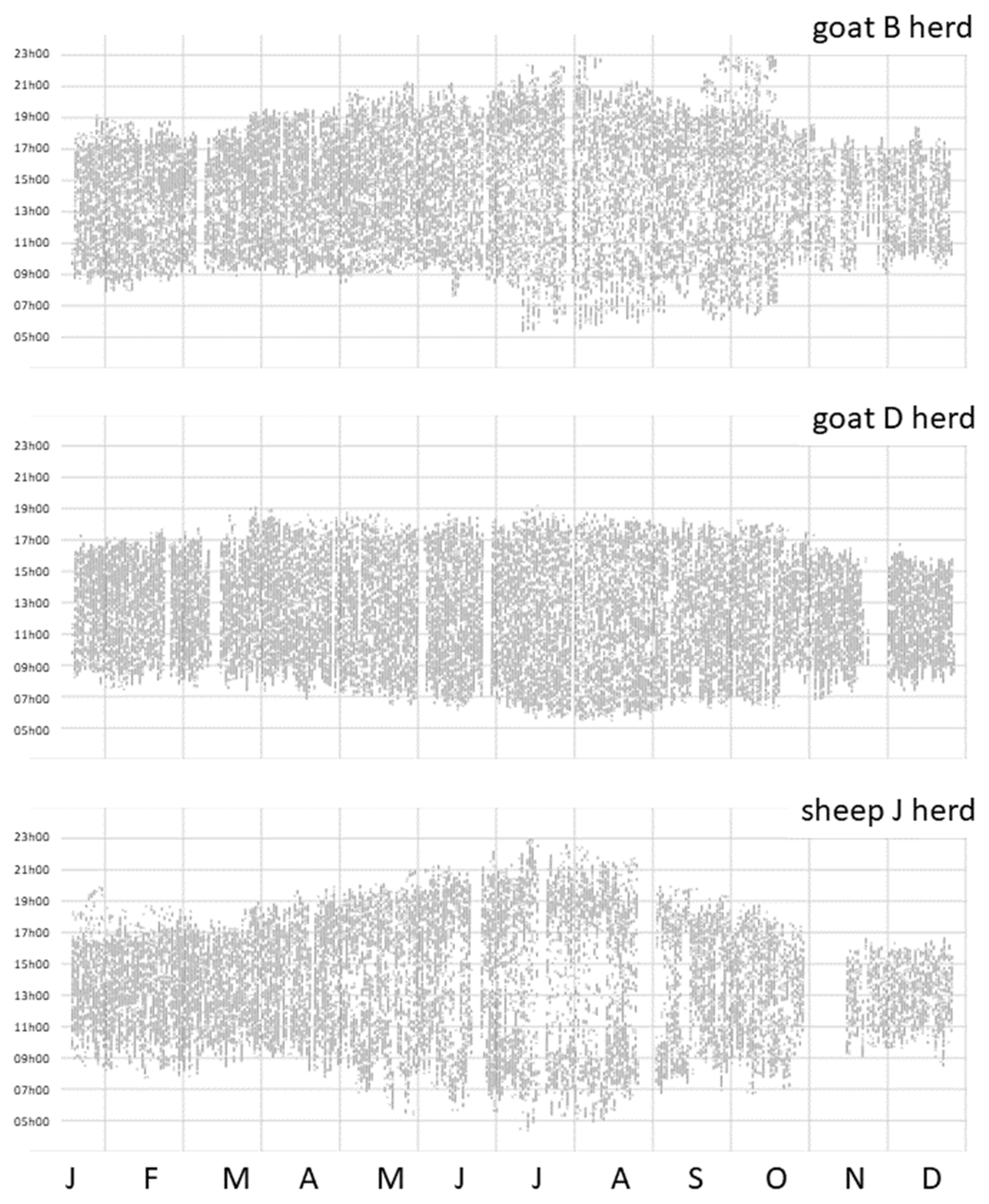
Figure 3.
Cumulative explained variance (Y) for three herds’ first 100 principal components (X) grazing density images.
Figure 3.
Cumulative explained variance (Y) for three herds’ first 100 principal components (X) grazing density images.
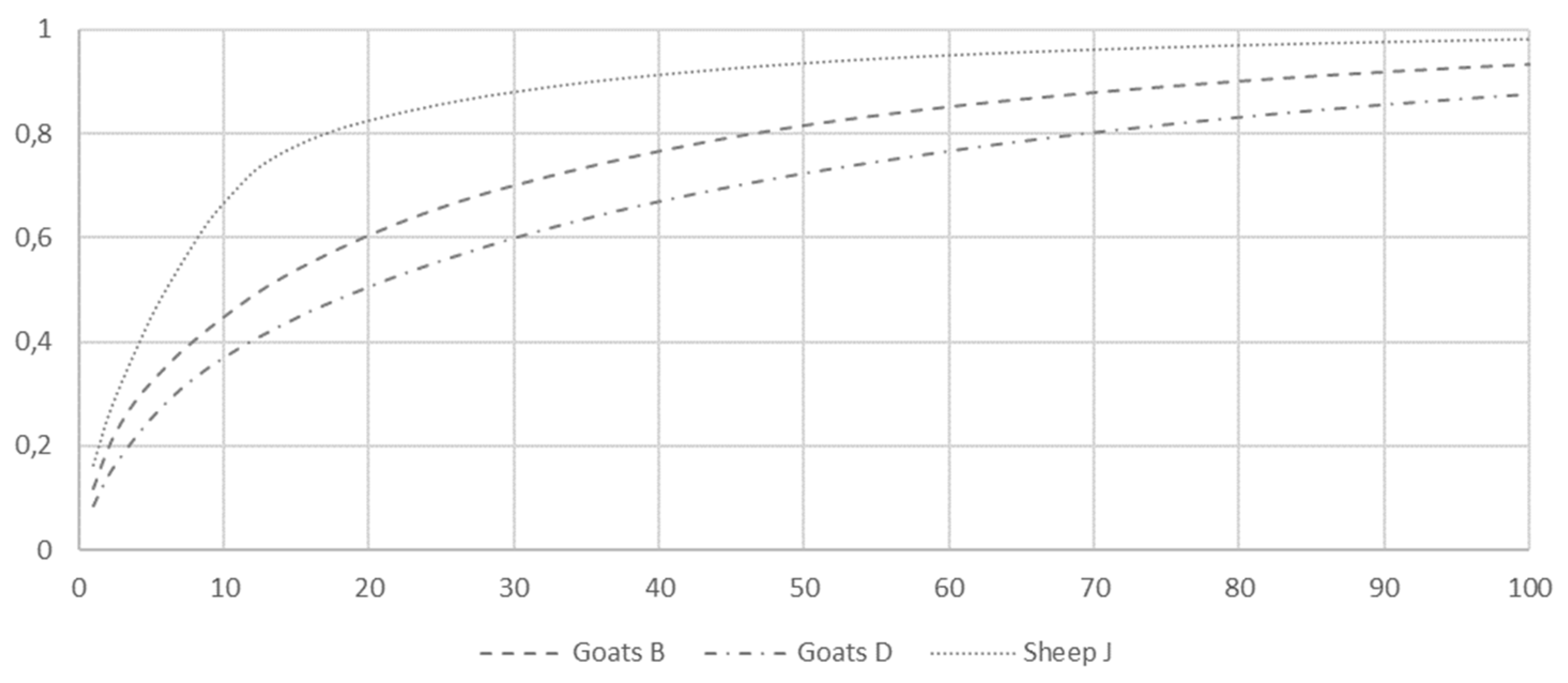
Figure 4.
PCA Scores (top) and Loadings (bottom) for Principal Components in goats B herd (refer to the text for further explanation).
Figure 4.
PCA Scores (top) and Loadings (bottom) for Principal Components in goats B herd (refer to the text for further explanation).
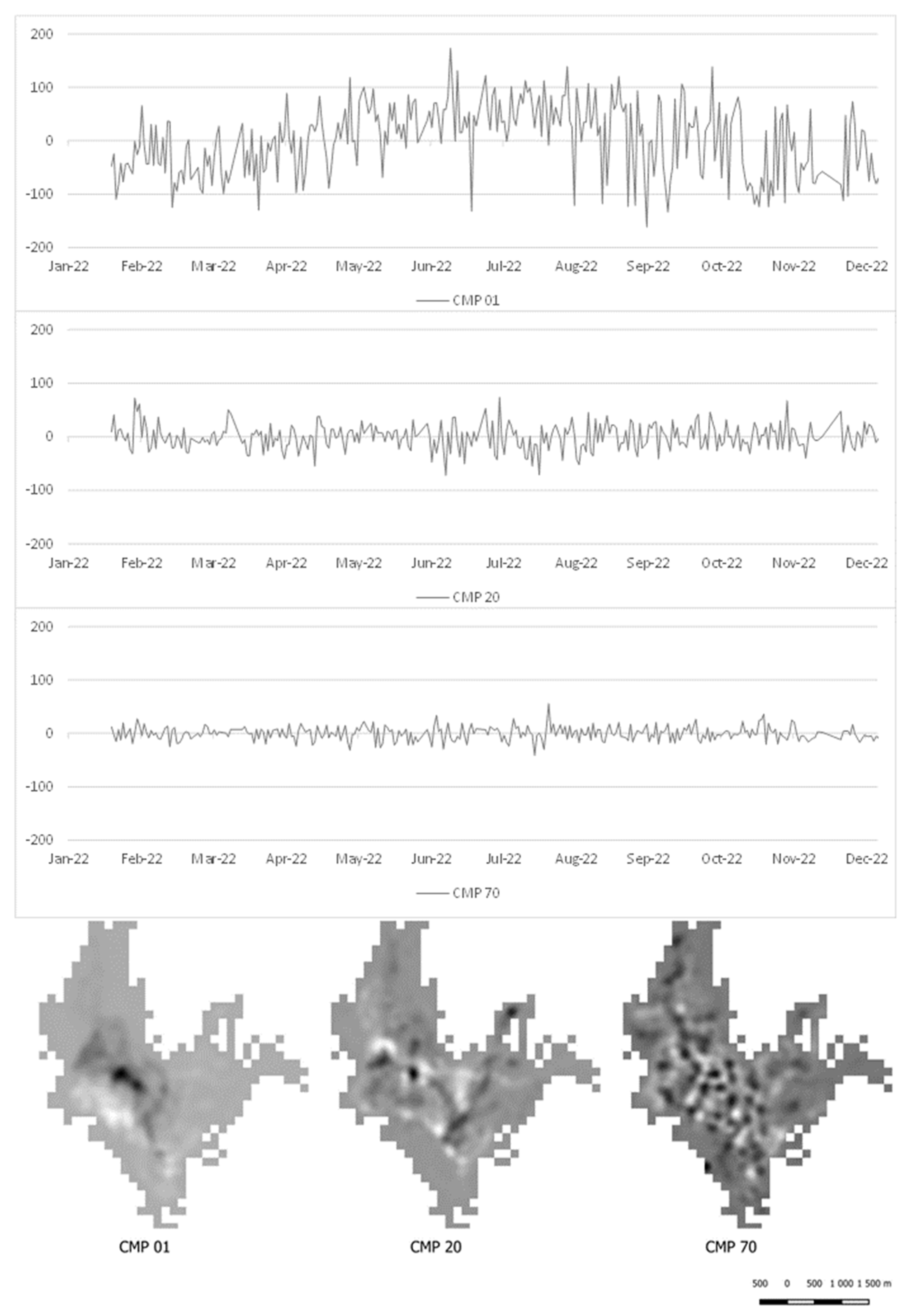
Figure 5.
PCA Scores (top) and Loadings (bottom) for Principal Components in goats D herd (refer to the text for further explanation).
Figure 5.
PCA Scores (top) and Loadings (bottom) for Principal Components in goats D herd (refer to the text for further explanation).
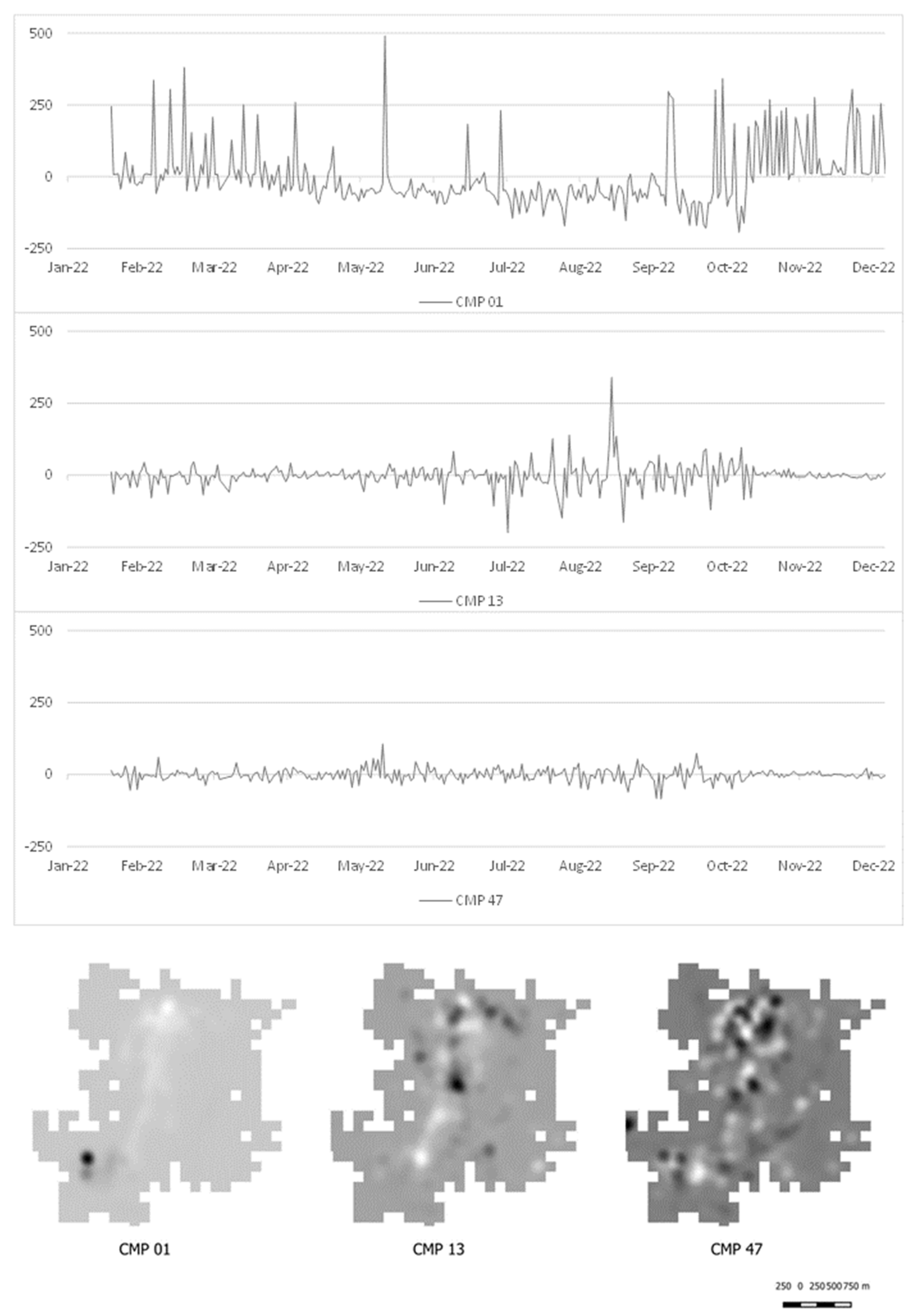
Figure 6.
PCA Scores (top) and Loadings (bottom) for Principal Components 01, 06, and 18 in sheep herd J (refer to the text for further explanation).
Figure 6.
PCA Scores (top) and Loadings (bottom) for Principal Components 01, 06, and 18 in sheep herd J (refer to the text for further explanation).
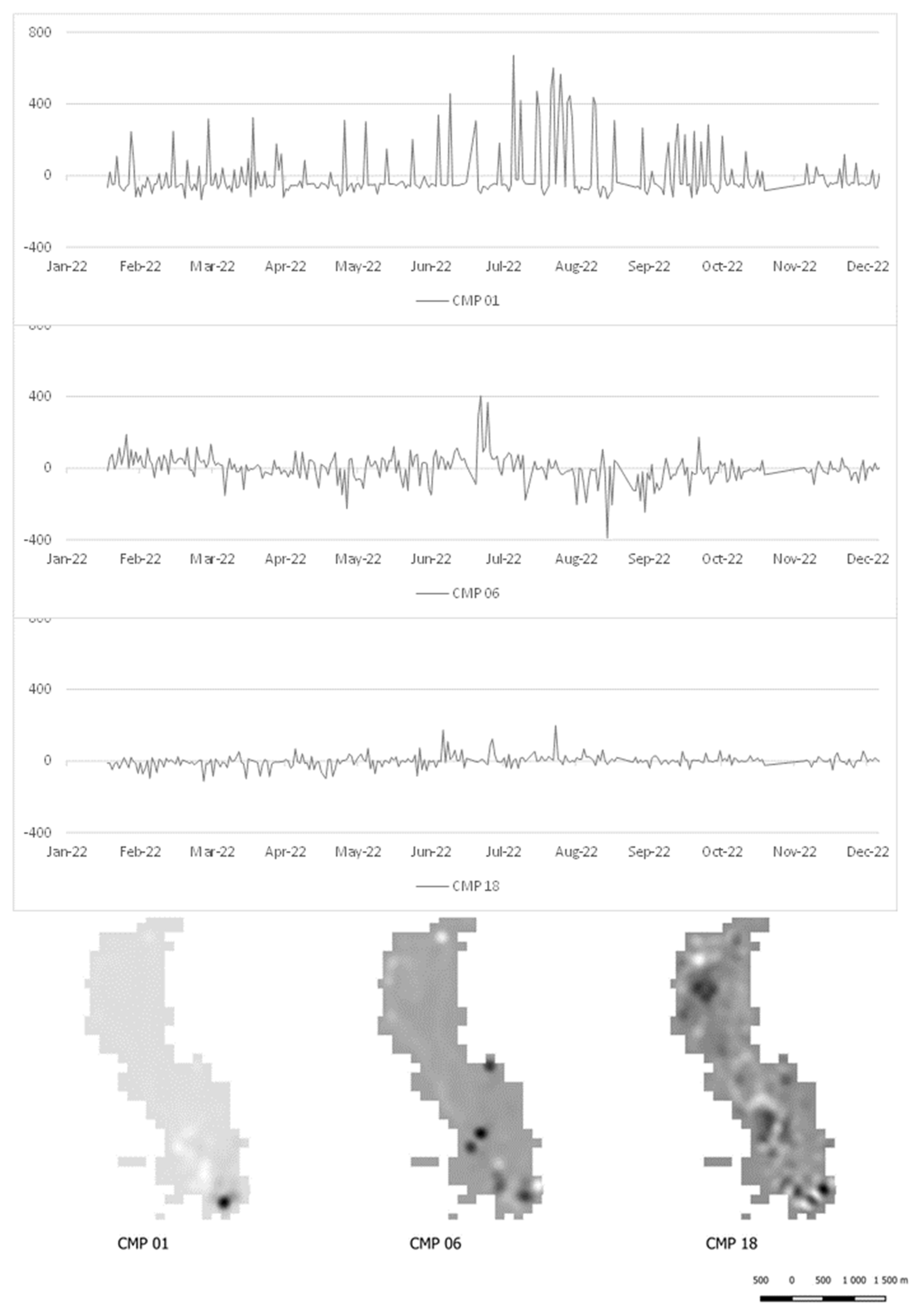
Figure 7.
The hierarchical organization of the grazing disturbance regime, from herders’ decisions to animals’ site preferences.
Figure 7.
The hierarchical organization of the grazing disturbance regime, from herders’ decisions to animals’ site preferences.
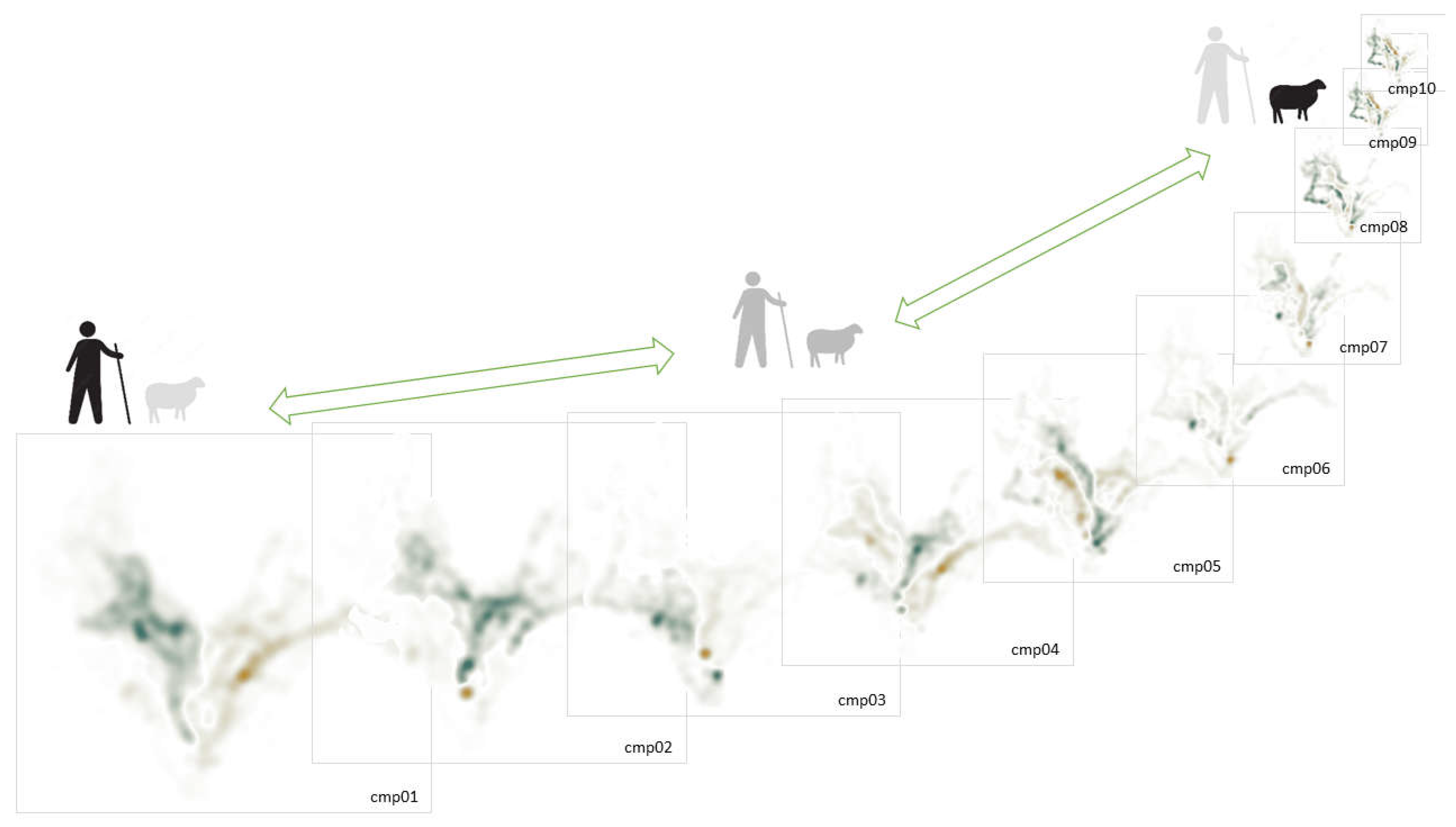

Table 1.
Corral location and elevation, breed, and size of experimental herds.
| Herd | Corral Location | Corral Elevation | Breed | Herd Size (2022) |
|---|---|---|---|---|
| Goats B | 08° 01’ 59.58" W 40° 56’ 38.67" N |
807 meters | Serrana | 140 to 150 |
| Goats D | 08° 04’ 39.72" W 40° 58’ 14.46" N |
704 meters | Serrana | 210 to 230 |
| Sheep J | 07° 55’ 22.03" W 40° 56’ 31.52" N |
830 meters | Bordaleira Serra da Estrela |
140 to 160 |
Table 2.
Locations records, number of grazing journeys, and maximum daily records for experimental herds.
Table 2.
Locations records, number of grazing journeys, and maximum daily records for experimental herds.
| Herd | Total Records | Records after Database Cleaning |
Grazing Journeys | Daily Maximum Records |
|---|---|---|---|---|
| Goats B | 31283 | 24300 | 325 | 118 (July 22) |
| Goats D | 30919 | 26279 | 312 | 116 (July 19) |
| Sheep J | 30452 | 20824 | 308 | 139 (June 27) |
Disclaimer/Publisher’s Note: The statements, opinions and data contained in all publications are solely those of the individual author(s) and contributor(s) and not of MDPI and/or the editor(s). MDPI and/or the editor(s) disclaim responsibility for any injury to people or property resulting from any ideas, methods, instructions or products referred to in the content. |
© 2024 by the authors. Licensee MDPI, Basel, Switzerland. This article is an open access article distributed under the terms and conditions of the Creative Commons Attribution (CC BY) license (http://creativecommons.org/licenses/by/4.0/).
Copyright: This open access article is published under a Creative Commons CC BY 4.0 license, which permit the free download, distribution, and reuse, provided that the author and preprint are cited in any reuse.


