
Submitted:
17 July 2024
Posted:
18 July 2024
You are already at the latest version
Abstract
In data-scarce regions, prudent planning and precise decision-making for sustainable development especially in agriculture remains a challenging task due to the lack of correct information. Remotely sensed satellite images provide a powerful source for assessing land use land cover (LULC) classes and crop identification. Applying Remote Sensing (RS) in conjunction with the Geographical Information System (GIS) and modern tools/ algorithms of artificial intelligence (AI) and deep learning has been proven effective for strategic planning and integrated resources management. The (this)study was conducted in the canal command area of the Lower Chenab Canal system in Punjab, Pakistan. Crop features/ classes were assessed using the Normalized Difference Vegetation Index (NDVI) algorithm. The MODIS (Moderate Resolution Imaging Spectroradiometer) 250 m and Landsat 5 TM (thematic mapper) images were deployed for NDVI time-series analysis with unsupervised classification technique to get LULC classes that helped to discern cropping pattern, crop rotation, and the area of specific crops, which were then used as a key input for agricultural mechanization planning and resources management. The accuracy of the LULC map was 78%, assessed by the error matrix approach. Limitations of high-resolution RS data availability and the accuracy of the results are the concerns observed in this study that could be managed by the availability of good quality local sources and advanced techniques of processing, which will make it more useful and applicable for regional agriculture and environmental management.
Keywords:
Remote sensing
; Geographical information system
; Vegetation index
; LULC classification
; Agricultural mechanization
; Strategic planning
; Resources management
; Artificial intelligence algorithms
; Crop phenology
; Satellite data
; Precision agriculture
1. Introduction
Natural resources that are being exploited for agricultural and ecosystem services are limited and confined in their nature, and thus, are under the burden of food security and ecosystem sustainability concerns for a steeply growing world population amid climate change scenarios. Sustainable development goals set by the United Nations for 2030, among which food security, prosperity, and sustainable environmental management components are important tasks to accomplish by researchers and experts in the field of agriculture and the environment [1]. These goals can be achieved through proper planning and data-driven decision-making based on reliable data sources. In areas with limited data availability and a lack of precise relevant information, prudent planning and decision-making for sustainable development especially in the fields of agriculture, ecosystem, and environment remain a tough task due to the lack of correct information [2].
Agricultural mechanization is crucial for overcoming labor shortages, improving the efficiency of the agricultural production system, and productivity enhancement of agricultural commodities. Ecological zoning and crop classification for specific regions are important to identify the needs for crop-specific, area-relevant, and specialized machines that can efficiently facilitate the farmers for their specific crops. Government policies should focus on the targeted farmers of any region according to their specific crops for the allocation and provision of machines and other subsidies [3]. Land and water resources are critical for sustainable agricultural development and ecosystem management. The allocation of resources should be prioritized according to national needs for food, fiber, and environmental quality management for the social and economic prosperity of the country. Planning and strategy development for concerned accomplishments require accurate information on opportunities, ecologies, landscapes, and available natural resources [1,2].
Physical surveys and manual data collection processes are inefficient, laborious, and time-consuming, yet still cannot provide sufficient and precise information required for strategic planning and sustainable resource management. Remotely sensed satellite images provide a powerful source to assess land use land cover (LULC) classes and crop identification. Applying Remote Sensing (RS) in conjunction with Geographical Information Systems (GIS) and modern tools/ algorithms of artificial intelligence (AI) and deep learning has been proven efficient and effective data sources for strategic planning and integrated resources management [4,5]. The application of remote sensing technology in agriculture has ushered in an era of precision farming, enabling detailed and accurate monitoring of crop growth, health, and distribution. Among the various remote sensing indices, the Normalized Difference Vegetation Index (NDVI) stands out due to its efficacy in vegetation monitoring. Utilizing NDVI time series data from MODIS (Moderate Resolution Imaging Spectroradiometer) VI and Landsat TM (Thematic Mapper) satellites has proven particularly valuable for localized crop classification [6]. This integration supports the development of mechanization strategies and effective land management, particularly beneficial for smallholding farmers.
MODIS and Landsat satellites offer unique advantages that, when combined, provide comprehensive crop monitoring solutions. MODIS delivers 8-day global coverage with a moderate spatial resolution of 250 meters, making it ideal for tracking vegetation changes over extensive areas with high temporal frequency. In contrast, Landsat provides higher spatial resolution (30 meters) with a 16-day revisit period, which is essential for detailed local analysis. Integrating these datasets allows for a nuanced understanding of crop dynamics, capturing both temporal and spatial variations in agricultural landscapes [5,6]. The hierarchical classification approach is commonly employed in NDVI time series analysis, beginning with the differentiation between crop and non-crop areas, followed by the identification of specific crop types. MODIS data captures essential phenological changes—the seasonal growth cycles of crops—that facilitate crop type differentiation. Landsat’s high-resolution imagery further refines this classification, providing the spatial detail necessary for accurate crop mapping. This combined approach has been effectively used in various regions, including the U.S. Central Great Plains and Mato Grosso, Brazil, demonstrating its versatility and reliability [7].
Advanced computational techniques, including AI, machine learning, and deep learning, have significantly enhanced crop classification accuracy. Algorithms such as Random Forests, Support Vector Machines, and neural networks can analyze complex NDVI time series data, identifying subtle patterns that distinguish between different crop types with high precision. The Savitzky-Golay filter is a notable preprocessing method that smooths NDVI time series data, reducing noise while preserving critical features, thus improving classification outcomes [8,9].
Assessing the accuracy of crop classification is crucial for ensuring the practical applicability of these methods. The density of NDVI time series data significantly impacts classification accuracy. Research indicates that denser time series from MODIS, coupled with historical ground truth data, enhances the sensitivity and specificity of classification models. Studies have reported classification accuracies reaching up to 90%, underscoring the effectiveness of integrated MODIS and Landsat data in agricultural monitoring [6].
Accurate crop classification is vital in developing efficient mechanization strategies for smallholding farmers. Detailed crop maps enable optimized deployment of agricultural machinery, reducing resource wastage and enhancing productivity. Site-specific management practices, guided by precise crop information, ensure that mechanization is adapted to the unique characteristics of each field. This precision is particularly beneficial for smallholding farms, where resource optimization is crucial for sustainability and profitability [10]. Regarding land management, accurate crop classification provides valuable insights into land use patterns and their changes over time. NDVI time series data aids in monitoring the conversion of natural landscapes to agricultural land and assessing the impact of these changes on biodiversity and ecosystem services. This information is essential for land use planning and conservation efforts, allowing policymakers and land managers to make informed decisions that balance agricultural productivity with environmental sustainability. Precision agriculture practices informed by detailed crop classification optimize field-level management based on intra-field variability, enhancing overall land-use efficiency [11,12].
Several case studies highlight the practical applications and benefits of NDVI time series analysis in crop classification. For example, a study that was conducted in Mato Grosso, Brazil, utilized MODIS EVI data to classify and monitor crops over a growing season. Integrating phenological information improved the accuracy of classification models, enabling the identification of different crop types and their growth stages. This approach provided a comprehensive understanding of crop dynamics, supporting better agricultural management and planning [5,7]. In the U.S. Central Great Plains, researchers employed time-series MODIS 250m NDVI data for large-area crop mapping. The hierarchical classification method effectively differentiated crops from non-crop areas and identified general crop types. This method is followed in this study that offered insights into the spatial and temporal dynamics of crops, aiding in the development of targeted mechanization strategies and land management practices [10,11,12].
This study aimed at the application of MODIS and Landsat satellite remote sensing data through NDVI time series analysis for localized LULC classification and crop identification. The process was based on the crop phenology dynamics that also include LULC map accuracy assessment, and information generation for future disposal in sustainable planning, mechanization strategy development, and integrated resources management. In smallholder farming regions, accurate crop classification has a profound impact on farm management practices. Detailed information on crop types and health allows smallholder farmers to make informed decisions about land preparation sowing/ planting schedules, fertilization regimes, pest control measures, harvesting and postharvest management, and mechanization applications.
2. Materials and Methods
2.1. Regional Description
Remote sensing-based research focuses on specific study areas, so describing the region’s characteristics is crucial. This region-based study covered two districts in Punjab, Pakistan: Faisalabad and Toba Tek Singh. The research was conducted in the Lower Chenab Canal (LCC) command area within the Rechna Doab, located between the Ravi and Chenab Rivers. Geographically, the study area lies between latitudes 30º 34ʹ and 31º 47ʹ N and longitudes 72º 10ʹ and 73º 40ʹ E, at an elevation of 184 meters above sea level. The total area covers 9,108 km², with 5,856 km² in Faisalabad and 3,252 km² in Toba Tek Singh.
The area includes three distinct agro-climatic zones: the Rice-Wheat Zone, Sugarcane-Cotton-Wheat Zone, and Cotton-Wheat Zone. The study spanned an entire cropping year from November to October, encompassing two cropping seasons: winter (Rabi) and summer (Kharif) [13]. This region is highly fertile, with alluvial soils deposited by floods, making it rich in agriculture. Intensive farming practices are prevalent, and major cash crops include wheat, rice, sugarcane, cotton, maize, orchards, vegetables, and fodder [13].
2.2. Data Description
The data collection section describes the data used with its source from where it was procured, implements used for data collection, data processing, and result extraction for the research. Data usage describes the data that was collected for the performance assessment and sustainable management of land and water resources consisting of Remote Sensing data (satellite images of MODIS and Landsat5 TM sensors), agriculture census data, soil type information, crop calendar, and crop phenology information. A summary of data, which were collected and used for research, is given in Table 1.
Remotely sensed satellite data were selected based on availability and applicability. There is a variety of satellites that were especially launched for earth observation and resource detection missions with a wide range of applications, and temporal and spatial resolution. MODIS was selected for this study due to regular high temporal resolution of 16 days, moderate spatial resolution of 250 meters, and availability. Cost is a big concern for research and there are very high costs for satellite images with fine/high spatial resolution. The satellites that produce high spatial resolution images their temporal resolution is very low as Ikonos with a spatial resolution of 1 meter produces only a single image per year this is another problem.
MODIS NDVI Time Series Data, MODIS sensor imagery data which was collected for the study consists of time series MODIS 250 meter NDVI composite images with 16 days temporal resolution of both Terra and Aqua satellites. This data was obtained for a whole cropping year from November to October of next year from an online MODIS data warehouse of NASA. This site offers radio-metrically and geo-metrically corrected 16-day synthesis MODIS VI products. The satellite images for the study area were procured with geo-referenced points which will be taken from the study area.
MODIS land products total of 46 (Aqua = 23 + Terra = 23) HDF-EOS (Hierarchical Data Format—Earth Observing System). By combining Terra and Aqua sensors products the temporal resolution becomes 8 days because there is an 8-day difference between Terra and Aqua if Terra takes an image on the 1st of any month, then Aqua Takes an image of the same terrain on the 8th of that month. This very fine 8-day temporal resolution is very supportive to discern crop growth stages on phenology bases. MODIS land products specially prepared for NDVI are MODIS Aqua: MYD13Q1 and MODIS Terra: MOD13Q1. The complete product name given based on the acquiring date, launching date, processing level, tile number, and product type are as follows in Table 2.
MODIS Aqua:
MYD13Q1.A2008297.h24v05.005.2008315064818_MODIS_Grid_16DAY_250m_500m_VI
MODIS Terra:
MOD13Q1.A2008305.h24v05.005.2008327041157_MODIS_Grid_16DAY_250m_500m_VI
MODIS tile size = 10º × 10º (geographic unit), i.e., ≈ 1200×1200 Km at the equator and varies from the equator towards poles, covering ≈ 1440000 km2 of land area.
Landsat5 TM Data, the spatial resolution of the Landsat mission is very good i.e., up to 10 meter pixel size but temporal provision is unreliable; only a few scenes were available for the whole year. For this study, 4 scenes of Landsat5 TM with a 30 meter spatial resolution and 7 spectral bands were procured from an online data facility. This data was used only for cross-matching and labeling purposes. Data address from Glovis data gateway and data size specification of both MODIS and Landsat sensors are shown in Figure 1. Specification of MODIS and Landsat spectral bands for this study are shown in Table 3.
2.3. Data Processing
This section provides a description of procedures, techniques, and rules that were used for data processing, data manipulation, and result extraction for the research. Cropping periods in the study area range from 90 to 150 days. Multi-temporal images of vegetation cover detect these changes.
Vegetation indices are based on the differential absorption, reflectance, and transmittance of spectral radiance by vegetation in the red and near-infrared regions. Green leaves absorb visible radiation and reflect near-infrared light, increased green leaf density increases the photosynthetic activity. The distinct patterns of green leaf development in various agroecosystems allow these ecosystems to be distinguished using time series analysis.
Preparation and Pre-processing of RS Data, before classifying the images for land use mapping, required some preparation and pre-processing because they were not produced for any special study. Data from both the sensors MODIS and Landsat5 TM was first prepared as required for the study. MODIS VI data which was procured from NASA’s remote sensing data center, was HDF format, which is not importable in ERDAS Imagine and ArcGIS. Additionally, the tile size of this data was very large, which was difficult to process. For the sake of simplicity and ease and to make the data importable in image analyzing software, it was converted to TIFF (Tagged Image File Format). Along with the format conversion, the images were clipped to retain only the study area (Rechna Doab) composite with an NDVI parameter layer. The procedure was performed using hegWINv2.1, which transformed raw HDF images into GeoTIFF format and reprojected them from the Integerized Sinusoidal (ISIN) projection to a geographic projection (latitude/longitude, World Geodetic System 1984-WGS84). [14]. The clipped image with the parent image file is shown in Figure 2 (a) and (b).
These images were stored in the data archive, so they were arranged according to normal dates using the Julian Date Calendar. MODIS NDVI images of both Terra and Aqua satellites were combined, which made the temporal resolution of 8 days which represented a true temporal analysis of vegetation. Throughout one year encompassing two cropping seasons from November to October, all images were consolidated into a composite file comprising 46 layers. This procedure was carried out using ERDAS Imagine 9.2, utilizing layer stacking techniques [15]. The objective was to assess temporal variations in vegetation cover and pinpoint stages of crop growth leveraging crop phenology. The MODIS NDVI data initially existed in 16-bit unsigned integer format, necessitating conversion to NDVI values before further analysis.
With the help of the above formula, this conversion was done by using a model maker [16]. Model maker is a powerful tool that is used for applying Mathematical and Statistical functions in several image analysis techniques.
Landsat5 TM Data, four scenes of Landsat5 TM of the study area were collected for the study period due to cloud effect problem images of Landsat are not available with consecutive regular time intervals. Therefore, only the images of good quality and free of cloud cover were selected. Landsat5 TM images were initially acquired with separate bands which were stacked to get multi-band composites of individual scenes. The four individual scenes each with 6 spectral bands were stacked to get a single multi-temporal and multi-spectral 24 bands pseudo-color map.
2.4. Unsupervised Classification
The analysis utilized ISODATA on MODIS NDVI composite images, processed every 8 days, to map land cover [17,18]. ISODATA, an unsupervised clustering method, employs a spectral distance formula to autonomously cluster data. This approach does not rely on expert input during classification. The annual stacked NDVI layer was categorized into 20 classes, with settings of 16 maximum iterations and a convergence threshold of 0.05. Maximum iterations ensure efficient processing by limiting operations, while the convergence threshold prevents perpetual execution by halting when pixel assignments stabilize [19]. The study selected a map and NDVI cluster profiles exhibiting minimal divergence for detailed analysis.
2.5. Supervised Classification of High-Resolution Data
Field survey data was employed to conduct supervised classification on a Landsat TM 4-layer composite pseudo-color image spanning a year. In supervised classification, the analyst guides the results using a signature file containing known pixel identities to classify unknown pixels into predefined classes. Among various methods, the maximum likelihood classifier (MLC) was chosen for its parametric approach, assuming data follow multivariate normal distributions. MLC considers not only the center of clusters but also their shape, size, and orientation, calculated through statistical distances using mean values and covariance matrices. Pixels are assigned to the class with the highest probability based on these distances. The resultant maps match the number of classes identified during field surveys, facilitating easier comparison with unsupervised maps.
2.6. Derivation of NDVI
The Normalized Difference Vegetation Index (NDVI) is derived by comparing the reflectance values of near-infrared and visible red bands using the formula [6]:
This index provides an indication of vegetation health and density based on how plants absorb and reflect light in these spectral bands.
The Normalized Difference Vegetation Index (NDVI) quantifies vegetation by comparing surface reflectance in specific MODIS bands: (846 to 885 nm) and (600 to 680 nm). Vegetation reflects near-infrared light strongly, which NDVI captures effectively. Healthy vegetation typically reflects little in the visible red spectrum (0.5 to 0.7 μm) but significantly in the near-infrared range (0.7 to 1.3 μm), influencing NDVI values. These values range from -1 to 1 after normalization, accounting for variations in illumination and terrain.
The NDVI values which were calculated as above were derived in tabular form to develop NDVI profiles for further investigation and analysis. This was also done by running the following model (Figure 3) through the ERDAS modeler panel.
Supervised Grouping of NDVI Profiles and Legend Construction, Landsat5 TM image with supervised classification was used. The legend for the period “November to October” was developed using stable land cover classes identified from the same-year Landsat classified data through overlay analysis.
Additionally, a significant aspect of the supervised grouping involved utilizing expert knowledge of crop phenology. This approach relied on visually examining temporal and spatial patterns, as well as crop growth stages within the study area. Grouping NDVI profiles based on their distinctiveness aided in preserving similar land cover classes effectively. This preparatory step was crucial before constructing the legend, as the grouped NDVI profiles were intended for change detection in subsequent analyses, thereby reducing the number of distinct NDVI profile groups. Grouping of NDVI profiles was done using a reclassification technique in a special analyst tool. The total area occupied by individual classes of several classes was calculated using a currently developed land use map for the region.
2.7. Validation and Accuracy
To assess the accuracy and consistency of satellite data, studies used two methods: the error matrix method with unsupervised classification and geo-referenced data, and a comparison of high-resolution land use maps from Landsat 5 TM data and Google Earth images with the newly developed map [20,21,22,23].
2.8. Mechanization Strategy, Land Resources and Ecosystem Management
According to the recognized major crops of the area, mechanization requirements were assessed for several farming operations like tillage, planting, intercultural operations, harvesting, postharvest processing, and farm residue management. Detailed crop maps derived from NDVI analysis also facilitate the planning and execution of site-specific management practices, ensuring that mechanization strategies are adapted to the variability within fields [6]. Furthermore, it supports the implementation of precision agriculture practices.
In the realm of land management, accurate crop classification provides valuable insights into land use patterns and changes over time. NDVI time series data helps track the conversion of natural landscapes to agricultural land and monitor the impact of land use changes on biodiversity and ecosystem services.
3. Results and Discussion
In this chapter, the results of investigations for all aspects of the present study are presented by keeping in view the objectives of the study set forth.
3.1. Land Use Mapping
Multi-temporal MODIS 250m NDVI images showed good potential for detecting crop-related LULC mapping, cropping periods, and crop rotations at a regional scale or command level. This was done due to high temporal, moderate spatial, good spectral resolutions, and global coverage of MODIS [11]. Figure 4 illustrates the effectiveness of MODIS time series imagery by comparing it with single date multi-spectral Landsat TM image.
Unsupervised MODIS map shows some classes merged e.g., developments of bare land and water presented in a single class but supervised Landsat TM map shows different classes for water developments and bare soil. Due to the large extent of MODIS pixels, the LULC map of MODIS shows some overestimation of classes. If a class was dominated by a pixel, then the entire pixel was assigned to that class.
3.2. Unsupervised Classification
Initially, the unsupervised ISODATA clustering technique was employed on MODIS imagery spanning an entire year to derive two primary clusters: (i) cultivated/cropped areas and (ii) uncultivated land covers, which include bare land, urban areas, and industrial developments. The division of the region into two classes gives the initial understanding of the variability in the region [16]. The absence of large water bodies, compact forests, and widespread gross lands urged for two initial classes. There is no bare land in the upper portion of the region ‘Faisalabad District’ but some patches in the lower boundaries of Toba Tek Singh. All cultivation is under irrigation which is why no rain-fed crops are detected in the region. But in some remote areas where irrigation water is not available, there is only wheat cultivation in the Rabi season and the land fellow in the Kharif season.
The unsupervised classification process was iterated, expanding the number of classes to twenty for enhanced detection of land use categories. This classification serves as the foundation for subsequent refinement and detailed analysis, particularly aimed at understanding the spatial distribution of crops within the study area. Utilizing a time series of MODIS imagery, multiple maps and signature cluster files (NDVI profiles) were generated, each configured with twenty predefined classes.
3.3. Supervised Classification
Supervised classification of Landsat TM imagery was assisted in the refinement of the unsupervised MODIS map. Using training site data, the Landsat image was classified into 10 classes, and due to fine resolution, it was easy to discern different crop classes. With the assistance of a supervised map, NDVI temporal profiles, and expert knowledge of cropping patterns existing in the study region, the MODIS map was reclassified in ArcGIS and only 10 well-identified classes were retained. Phenological patterns of crops extracted from RS data and represented by NDVI temporal profiles are good tools for crop differentiation [21,22]. Unidentified classes were merged based on similarities between them. Finally, retained classes showed a good divergence between distinct classes.
3.4. Phenology
In initial ISODATA clustering, only two clusters were applied one with vegetation, which was cultivated, and the other without vegetation, which includes bare land, urban development, and Industrial development. NDVI value looked maximum for vegetative/ cultivated cover and minimum without vegetation and showed a straight line pattern because there is no reflectance of NIR from this class. Then the number of clusters was increased to identify the land use. This clustering was given up into a first round of 20 classes with the help of which further refinement was made and analysis was done. This clustering was applied with the concern of cropping calendar and domination of a specific crop in the area.
Crop clusters were delineated using NDVI temporal profiles and expert knowledge of cropping patterns. Field data collected during ground trothing led to the consolidation of some classes. Similarities in NDVI profiles were observed during the merging of clusters, reducing the number of classes from 20 to 10 agricultural categories. The average NDVI temporal profiles of these final agricultural classes are depicted in Figure 5.
Figure 5 demonstrates the distinctiveness of these 10 classes, each exhibiting unique phenological characteristics. The ISODATA clustering method successfully differentiated phenological variations such as the onset and cessation of the growing season and the duration of growth for specific crops. The presence of dual peaks within an annual cycle (Figure 5) signifies regions practicing intensive irrigation and multi-cropping systems. These peaks mark the beginning and end of major crop types cultivated within the study area.
The “wheat-rice rotation” cluster exhibits two prominent peaks: one at the end of January to early February and another at the end of August. These peaks align with the cropping seasons: wheat is cultivated from November to April (Rabi), while rice grows from June to October (Kharif). This cluster predominantly comprises cultivated areas, with minimal fallow land, resulting in higher NDVI values compared to other crop types.
The class of “wheat cotton rotation” has lower NDVI values as compared to “rice wheat rotation” and the peak timing of this class may differ due to differences in sowing time and changed climatic conditions as the weather affects the crop growth. After cotton, the wheat sowing is normally delayed due to the late harvesting of cotton. The NDVI curves of water-deficient crops exhibit trends similar to adequately irrigated ones but with lower NDVI values. In contrast, the “wheat fallow” class displays a distinct trend compared to other crops, characterized by the exclusive cultivation of rabi crops, primarily wheat. Throughout the rest of the year, NDVI values remain flat, indicating a lack of distinct vegetation patterns. Figure 6 represents the final raster map of 10 classes.
3.5. Areal Distribution of LULC Classes
The areal extent of each land cover class for the unsupervised classification results is summarized and represented in Figure 7. Wheat-fodder mix with 175,900 ha is the class with maximum areal extant, but wheat is the most prominent crop of the Rabi season. The agriculture of this region is irrigated, about 75% to 80% through canal irrigation and the other 20% to 25% by tube well. The NDVI phenological patterns in Figure 5 reveal predominant biennial cropping cycles, with major crop rotations including wheat-cotton (10.23%), wheat-rice (9.65%), wheat-maize (3.40%), wheat-fodder-mix (19.26%), and sugarcane-cotton-mix (18.24%). Sugarcane and wheat appeared to be the most prominent crops with an estimated area of 176,000 ha and 477,500 ha respectively, which were found 80% and 94% accurate when compared with the reported area by the Punjab Board of Statistics. This can be explained by the reason that the total area of one pixel is 6.25 ha (250 m×250 m) which is 15.44 acre and land within one pixel does not consist of agricultural fields with homogeneous crops. The field unit size in this region is 1 acre and the land holding pattern of the region is very small, a survey reported about 83% of the respondents have less than 10 acre of land holding.
3.6. Major Crop Rotations and Area
From the LULC final 10 classes map (Figure 6) and phenological patterns of these final classes (Figure 5), it is declared that there is intensive cropping in the area, with two or three crops grown per year. The prominent crop rotations are “wheat rice rotation”, “wheat cotton rotation”, “wheat maize rotation”, “sugarcane cotton wheat mix rotation” and “wheat fodder rotation”. From these rotations, it is evident wheat is the most dominant crop of the Rabi season in the area in rotation with Kharif season crops like rice, cotton, maize, and sugarcane. After wheat, the second dominant crop is sugarcane which covers about 17.31% of the cultivated area.
3.7. Accuracy Assessment
To check the level of accuracy and reliability of LULC classified map many accuracy assessment methods have been introduced [6,16]. Two types of accuracy assessments were applied in this study.
3.7.1. Ground Trothing
The accuracy of the LULC classification was assessed using the error matrix method. This involved comparing map classes generated during classification with ground truth data collected from 128 survey points.
The error matrix revealed an overall map accuracy of 78%, with user’s and producer’s accuracies at 78% and 77% respectively. This indicates that 78% of the land use classes identified on the map match field observations. The study noted that the satellite data’s coarse resolution (6.25 ha) and small field sizes (0.4 ha) contributed to this level of accuracy, which aligns with findings from similar crop identification studies. The research suggests that with extensive fieldwork, crop identification can achieve an average accuracy of 86%, though this accuracy varies widely (49% to 96%) based on satellite data resolution and field size [16].
3.8. Mechanization Strategy
According to the recognized major crops of the area, mechanization requirements were assessed for several farming operations like tillage, planting, intercultural operations, harvesting, postharvest processing, and farm residue management. Accurate crop classification is essential for developing effective mechanization strategies [24,25]. Understanding the spatial distribution and health of crops enables the optimized deployment of agricultural machinery for planting, irrigation, fertilization, and harvesting. This precision reduces resource wastage and increases productivity, which is especially crucial in large-scale farming operations. Detailed crop maps derived from NDVI analysis also facilitate the planning and execution of site-specific management practices, ensuring that mechanization strategies are adapted to the variability within fields [6,23,26]. Furthermore, it supports the implementation of precision agriculture practices, which aim to optimize field-level management based on the variability in crops and soil within a field.
3.9. Land Resources and Ecosystem Management
In the realm of land management, accurate crop classification provides valuable insights into land use patterns and changes over time. NDVI time series data helps track the conversion of natural landscapes to agricultural land and monitor the impact of land use changes on biodiversity and ecosystem services [26]. This information is crucial for land use planning and conservation efforts, enabling policymakers and land managers to make informed decisions that balance agricultural productivity with environmental sustainability. This information can help optimize land use, such as identifying areas suitable for specific crops or facilitating the implementation of crop rotation practices. Additionally, crop classification can aid in the optimization of irrigation resources [27].
5. Conclusions
In regions with limited data, effective planning and decision-making for sustainable agricultural development are challenging due to inadequate information. Remotely sensed satellite images offer a powerful tool for assessing land use and identifying crops. Combining Remote Sensing (RS) with Geographic Information System (GIS), and leveraging AI and deep learning algorithms, has proven effective for strategic planning and resource management. A study in the Lower Chenab Canal area in Punjab, Pakistan, used the Normalized Difference Vegetation Index (NDVI) algorithm to assess crop features. MODIS and Landsat 5 TM images facilitated NDVI time-series analysis and unsupervised classification to obtain LULC classes, which helped identify cropping patterns, rotations, and specific crop areas. These insights were critical for planning agricultural mechanization and resource management.
The supervised grouping of NDVI profiles produced favorable outcomes. Furthermore, conducting statistical analysis is essential to evaluate variance within or between groups. The LULC map accuracy was 78%, determined using an error matrix. However, the study highlighted concerns over the availability of high-resolution RS data and result accuracy, which could be improved with better local data sources and advanced processing techniques, enhancing its applicability for regional agricultural and environmental management.
Despite significant advancements, challenges in crop classification using NDVI time series persist. Variability in spectral signatures of different crops, particularly in mixed cropping systems, can complicate classification efforts. Additionally, cloud cover and atmospheric conditions can affect the quality of remote sensing data, necessitating the use of advanced algorithms to mitigate these issues. Future research should focus on improving data fusion techniques, integrating multiple sensors, and developing robust models capable of handling diverse agricultural landscapes. Incorporating machine learning models that adapt to varying conditions and leveraging big data analytics will further enhance the accuracy and reliability of crop classification. As technology continues to evolve, the potential for further advancements in crop classification and agricultural management remains significant, promising ongoing benefits for the agricultural sector worldwide.
In smallholder farming regions, accurate crop classification has a profound impact on farm management practices. Detailed information on crop types and health allows smallholder farmers to make informed decisions about planting schedules, fertilization regimes, and pest control measures. This leads to increased yields and improved food security for communities reliant on small-scale agriculture. Implementing NDVI time series analysis in these areas has demonstrated significant enhancements in crop monitoring and support for sustainable agricultural practices.
Supplementary Materials
N/A.
Author Contributions
Conceptualization, H.Md-T., U.K.A. and M.J.M.C.; methodology, H.Md-T. and M.J.M.C.; software, H.Md-T. and M.J.M. C.; validation, H.Md-T., H.S.M., M.T. and M.A.; formal analysis, H.Md-T. and M.H.; investigation, H.Md-T. and M.H.; resources, A.K., M.T.; data curation, H.Md-T., M.S.; writing—original draft preparation, H.Md-T., M.T., Y.A.K. and A.K.; writing—review and editing, A.K., M.A., M.M.A,; visualization, A.K. and M.S.; supervision, U.K.A. All authors have read and agreed to the published version of the manuscript.
Funding
This research received no external funding.
Data Availability Statement
All the data supporting the conclusions of this article is included in the article.
References
- Viana, C. M., Freire, D., Abrantes, P., Rocha, J., & Pereira, P. (2022). Agricultural land systems importance for supporting food security and sustainable development goals: A systematic review. Science of the total environment, 806, 150718. [CrossRef]
- Blickensdörfer, L., Schwieder, M., Pflugmacher, D., Nendel, C., Erasmi, S., & Hostert, P. (2022). Mapping of crop types and crop sequences with combined time series of Sentinel-1, Sentinel-2, and Landsat 8 data for Germany. Remote sensing of environment, 269, 112831. [CrossRef]
- Takeshima, H., Hatzenbuehler, P. L., & Edeh, H. O. (2020). Effects of agricultural mechanization on economies of scope in crop production in Nigeria. Agricultural Systems, 177, 102691. [CrossRef]
- Saiz-Rubio, V., & Rovira-Más, F. (2020). From smart farming towards agriculture 5.0: A review on crop data management. Agronomy, 10(2), 207. [CrossRef]
- Huang, Y., Chen, Z. X., Tao, Y. U., Huang, X. Z., & Gu, X. F. (2018). Agricultural remote sensing big data: Management and applications. Journal of Integrative Agriculture, 17(9), 1915-1931. [CrossRef]
- Wardlow, B. D., Egbert, S. L., & Kastens, J. H. (2007). Analysis of time-series MODIS 250 m vegetation index data for crop classification in the US Central Great Plains. Remote sensing of environment, 108(3), 290-310. [CrossRef]
- Arvor, D., Jonathan, M., Meirelles, M. S. P., Dubreuil, V., & Durieux, L. (2011). Classification of MODIS EVI time series for crop mapping in the state of Mato Grosso, Brazil. International Journal of Remote Sensing, 32(22), 7847-7871. [CrossRef]
- Li, Q., Wang, C., Zhang, B., & Lu, L. (2015). Object-based crop classification with Landsat-MODIS enhanced time-series data. Remote Sensing, 7(12), 16091-16107. [CrossRef]
- Mirzaei, A., Bagheri, H., & Khosravi, I. (2023). Enhancing Crop Classification Accuracy through Synthetic SAR-Optical Data Generation Using Deep Learning. ISPRS International Journal of Geo-Information, 12(11), 450. [CrossRef]
- Ouzemou, J. E., El Harti, A., Lhissou, R., El Moujahid, A., Bouch, N., El Ouazzani, R., ... & El Ghmari, A. (2018). Crop type mapping from pansharpened Landsat 8 NDVI data: A case of a highly fragmented and intensive agricultural system. Remote Sensing Applications: Society and Environment, 11, 94-103. [CrossRef]
- Wardlow, B. D., & Egbert, S. L. (2008). Large-area crop mapping using time-series MODIS 250 m NDVI data: An assessment for the US Central Great Plains. Remote sensing of environment, 112(3), 1096-1116. [CrossRef]
- Sergieieva, K., Kavats, O., Khramov, D., Vasyliev, V., & Kavats, I. (2018, December). Crop Classification and Monitoring using MODIS NDVI Time Series. In AGU Fall Meeting Abstracts (Vol. 2018, pp. GC51G-0861).
- Jehangir, W. A., Qureshi, A. S., & Ali, N. (2002). Conjunctive water management in the Rechna Doab: An overview of resources and issues.
- Evrendilek, F., & Gulbeyaz, O. (2008). Deriving vegetation dynamics of natural terrestrial ecosystems from MODIS NDVI/EVI data over Turkey. Sensors, 8(9), 5270-5302. [CrossRef] [PubMed]
- Biggs, T. W., Rao, P. G., & Bharati, L. (2010). Mapping agricultural responses to water supply shocks in large irrigation systems, southern India. Agricultural Water Management, 97(6), 924-932. [CrossRef]
- Cheema, M. J. M., & Bastiaanssen, W. G. (2010). Land use and land cover classification in the irrigated Indus Basin using growth phenology information from satellite data to support water management analysis. Agricultural water management, 97(10), 1541-1552. [CrossRef]
- Di Gregorio, A. (2005). Land cover classification system: classification concepts and user manual: LCCS (Vol. 2). Food & Agriculture Org.
- Ledwith, M. (2002, April). Land cover classification using SPOT Vegetation 10-day composite images–Baltic Sea catchment basin. In GLC2000 Meeting, Ispra, Italy, April (pp. 18-22).
- Dogan, H. M., & Kılıç, O. M. (2013). Modelling and mapping some soil surface properties of Central Kelkit Basin in Turkey by using Landsat-7 ETM+ images. International journal of remote sensing, 34(15), 5623-5640. [CrossRef]
- Latifovic, R., & Olthof, I. (2004). Accuracy assessment using sub-pixel fractional error matrices of global land cover products derived from satellite data. Remote sensing of Environment, 90(2), 153-165. [CrossRef]
- Ray, S. S., Dadhwal, V. K., & Navalgund, R. R. (2002). Performance evaluation of an irrigation command area using remote sensing: a case study of Mahi command, Gujarat, India. Agricultural water management, 56(2), 81-91. [CrossRef]
- Abdulraheem, M. I., Zhang, W., Li, S., Moshayedi, A. J., Farooque, A. A., & Hu, J. (2023). Advancement of remote sensing for soil measurements and applications: A comprehensive review. Sustainability, 15(21), 15444. [CrossRef]
- Raza, A., Syed, N. R., Fahmeed, R., Acharki, S., Aljohani, T. H., Hussain, S., ... & Abdo, H. G. (2024). Investigation of changes in land use/land cover using principal component analysis and supervised classification from operational land imager satellite data: a case study of under developed regions, Pakistan. Discover Sustainability, 5(1), 73. [CrossRef]
- Md-Tahir, H., Zhang, J., Xia, J., Zhang, C., Zhou, H., & Zhu, Y. (2019). Rigid lugged wheel for conventional agricultural wheeled tractors–optimising traction performance and wheel–soil interaction in field operations. Biosystems engineering, 188, 14-23. [CrossRef]
- Md-Tahir, H., Zhang, J., Xia, J., Zhou, Y., Zhou, H., Du, J., & Mamona, H. (2021). Experimental investigation of traction power transfer indices of farm-tractors for efficient energy utilization in soil tillage and cultivation operations. Agronomy, 11(1), 168. [CrossRef]
- Sishodia, R. P., Ray, R. L., & Singh, S. K. (2020). Applications of remote sensing in precision agriculture: A review. Remote sensing, 12(19), 3136. [CrossRef]
- Ashraf, A., Ahmad, L., Ferooz, K., Ramzan, S., Ashraf, I., Khan, J. N., ... & Nazir, S. (2023). Remote Sensing as a Management and Monitoring Tool for Agriculture: Potential Applications. International Journal of Environment and Climate Change, 13(8), 324-343. [CrossRef]
Figure 1.
Satellite data downloading parameters e.g., (a) H = 24, V = 05 is the horizontal and vertical tile number of MODIS respectively (tile size =10º×10º Latitude, Longitude), (b) Path = 150, Row = 38 is the address of Landsat5 TM images (tile size is approximately 170 km north-south by 183 km east-west).
Figure 1.
Satellite data downloading parameters e.g., (a) H = 24, V = 05 is the horizontal and vertical tile number of MODIS respectively (tile size =10º×10º Latitude, Longitude), (b) Path = 150, Row = 38 is the address of Landsat5 TM images (tile size is approximately 170 km north-south by 183 km east-west).
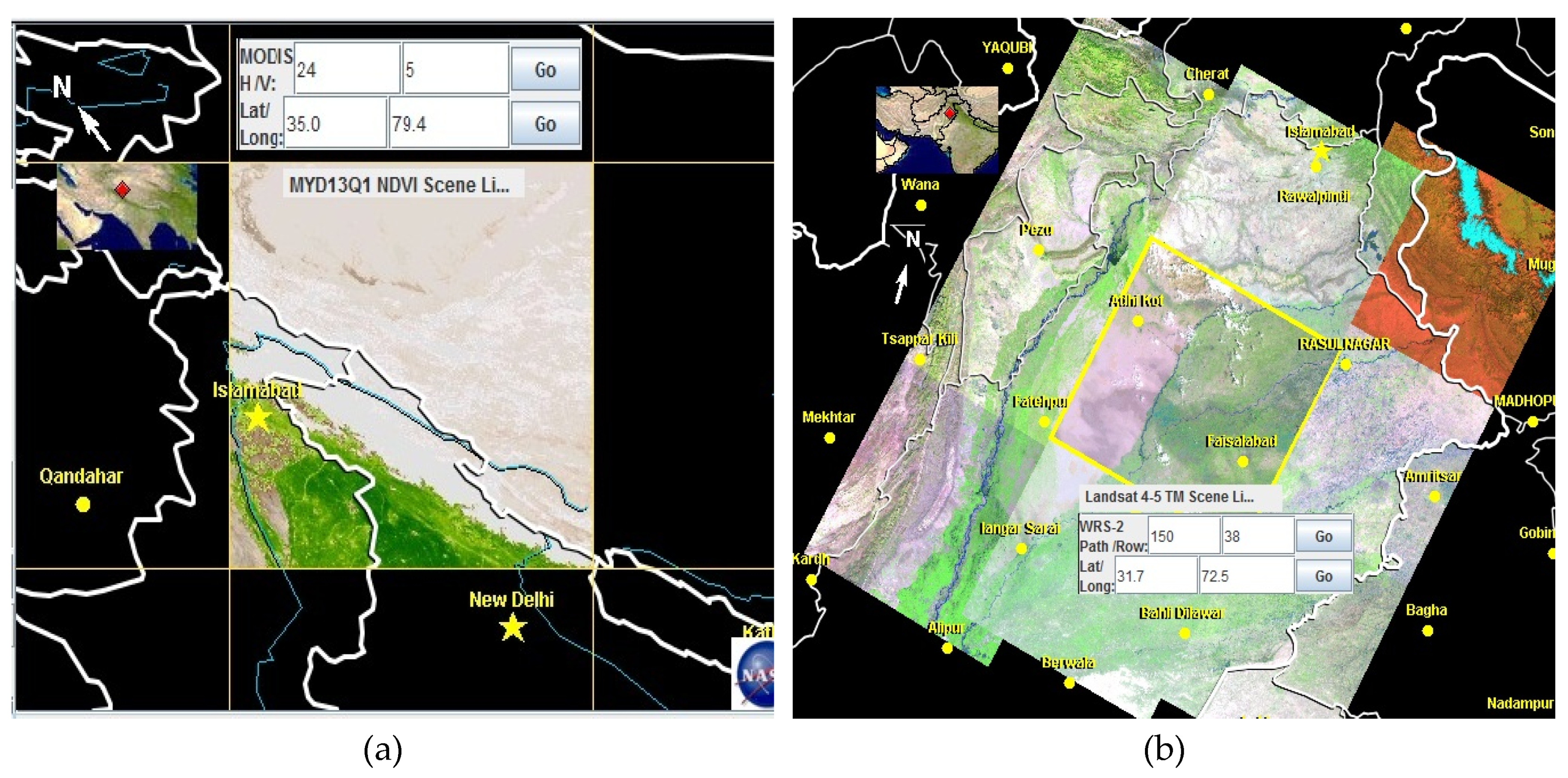
Figure 2.
MODIS data for study area: (a) Original MODIS NDVI tile h24v05 covers one-fourth of the Pakistan area. (b) Subset and layer stack of MODIS image of study area “Rachna Doab”.
Figure 2.
MODIS data for study area: (a) Original MODIS NDVI tile h24v05 covers one-fourth of the Pakistan area. (b) Subset and layer stack of MODIS image of study area “Rachna Doab”.
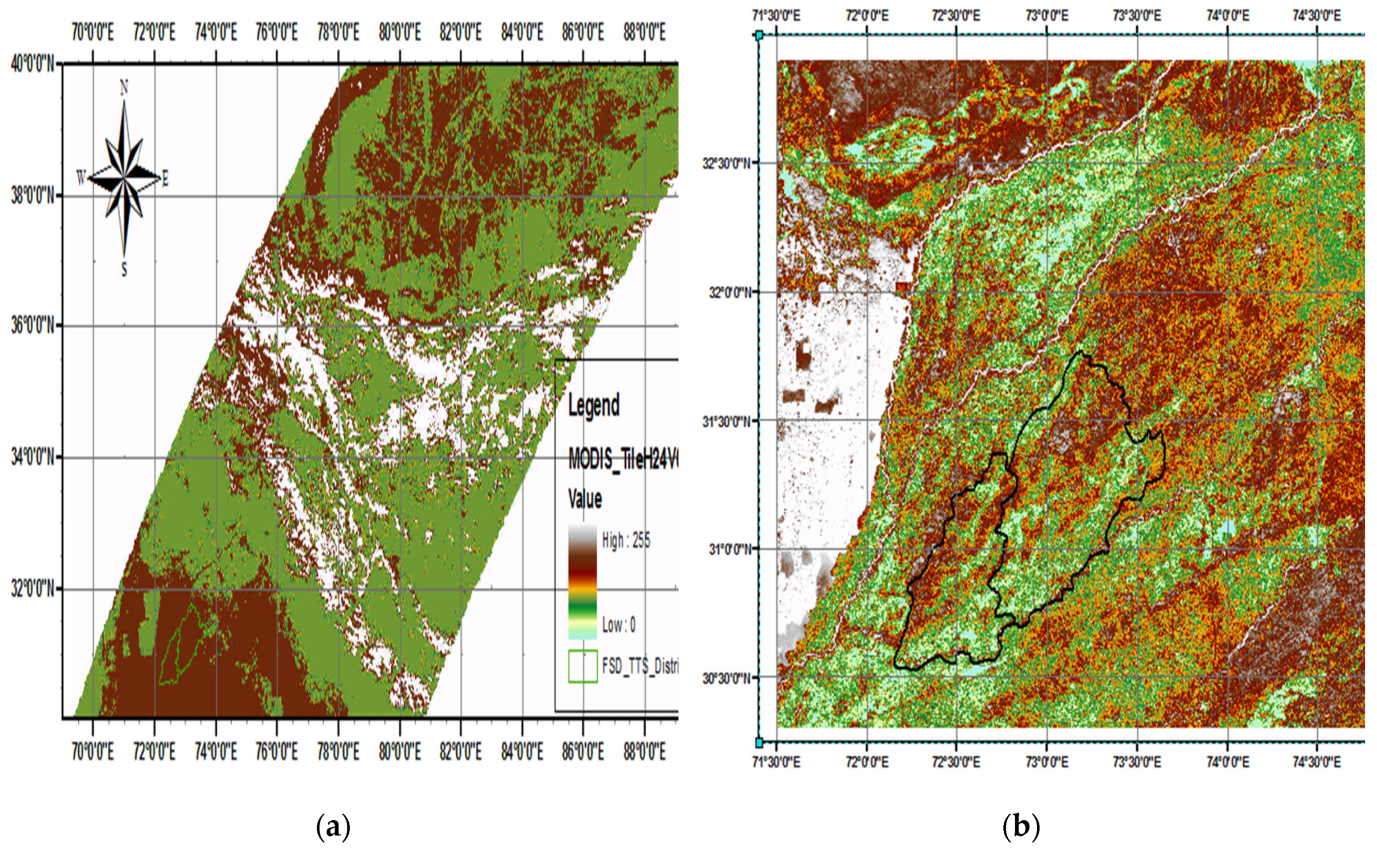
Figure 3.
Model for digital values of NDVI derivation.
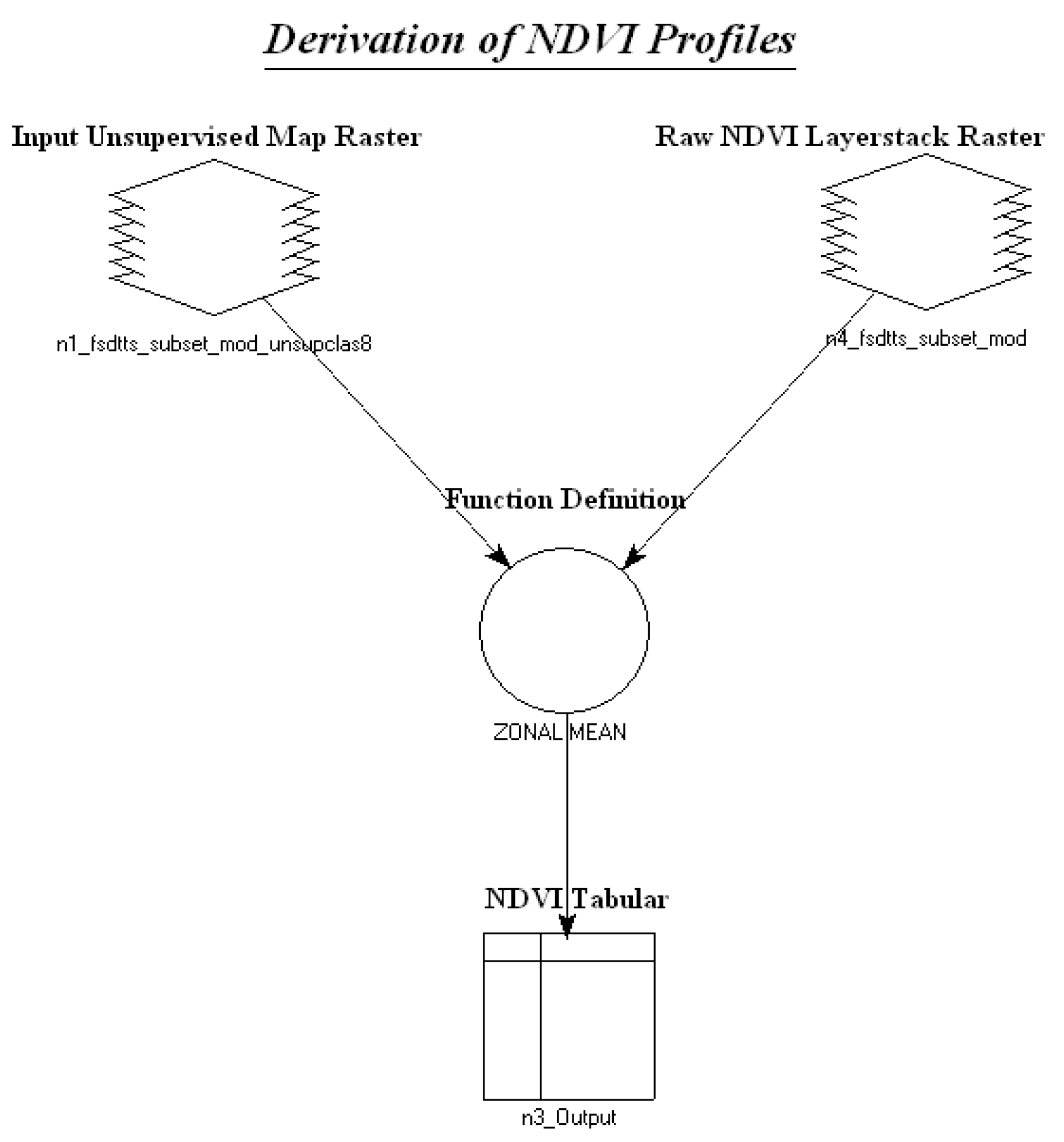
Figure 4.
Comparison of currently developed LULC map (a) from MODIS with (b) fine resolution Landsat5 TM map.
Figure 4.
Comparison of currently developed LULC map (a) from MODIS with (b) fine resolution Landsat5 TM map.
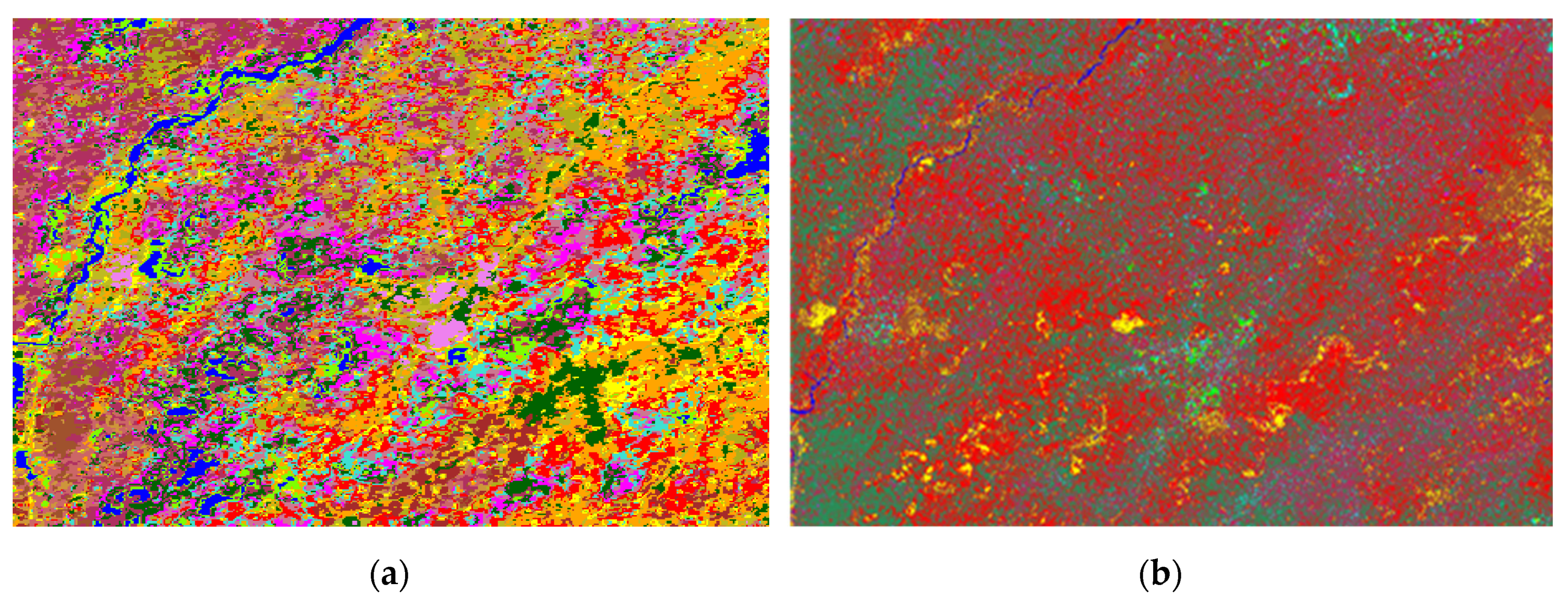
Figure 5.
Crop phenology and NDVI profiles of final agriculture/ crop classes.
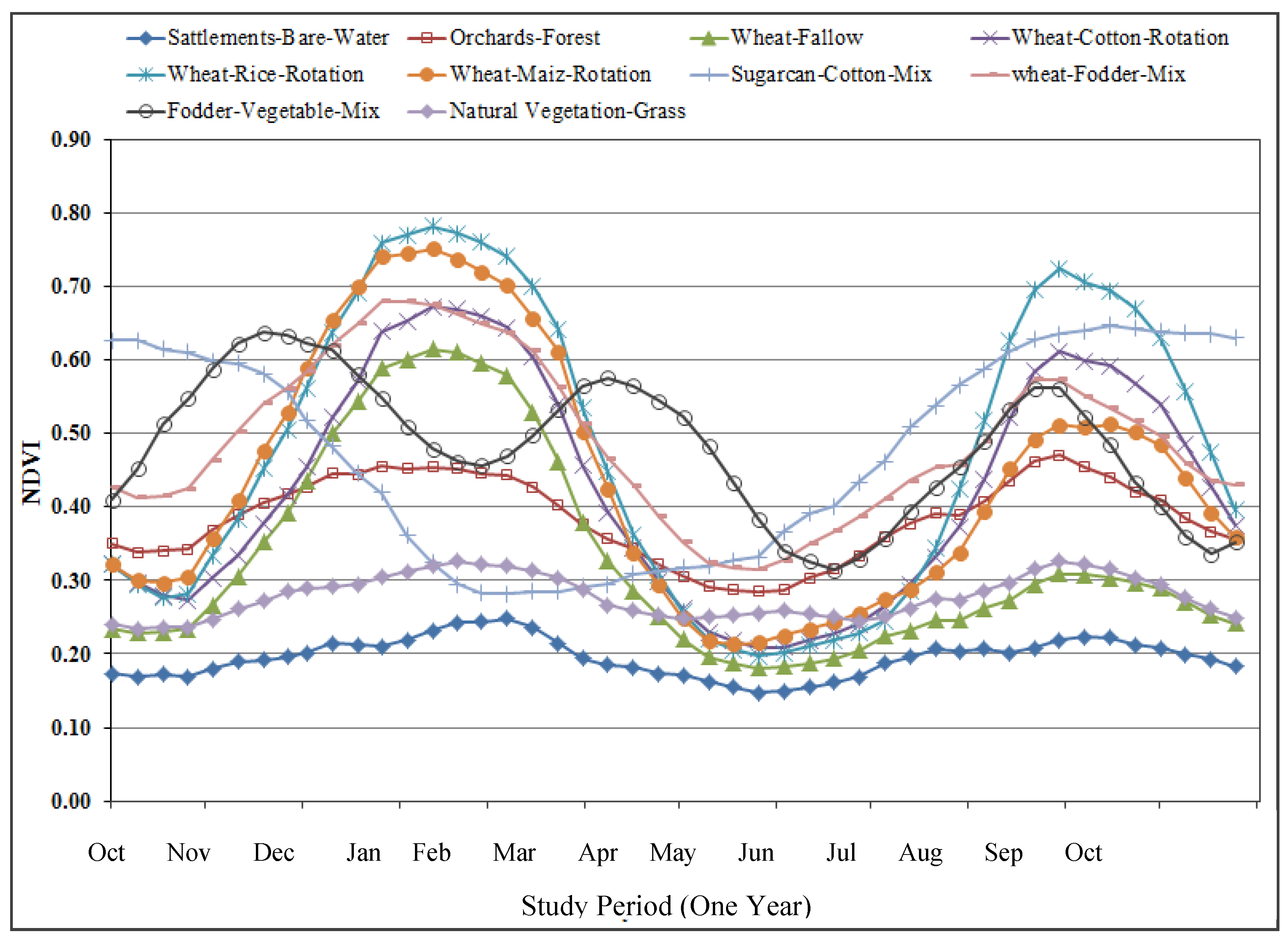
Figure 6.
Land cover and land use map developed from 46 MODIS NDVI layers for the year 2008-09.
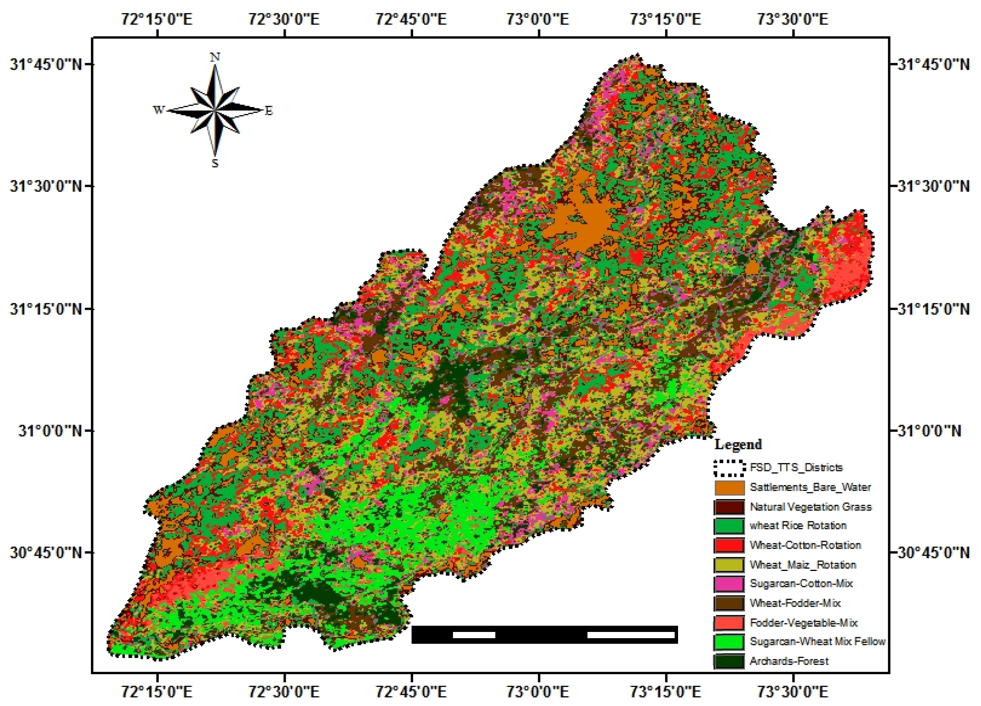
Figure 7.
LULC classes and their areal extent in Faisalabad and Toba Tek Singh Districts.
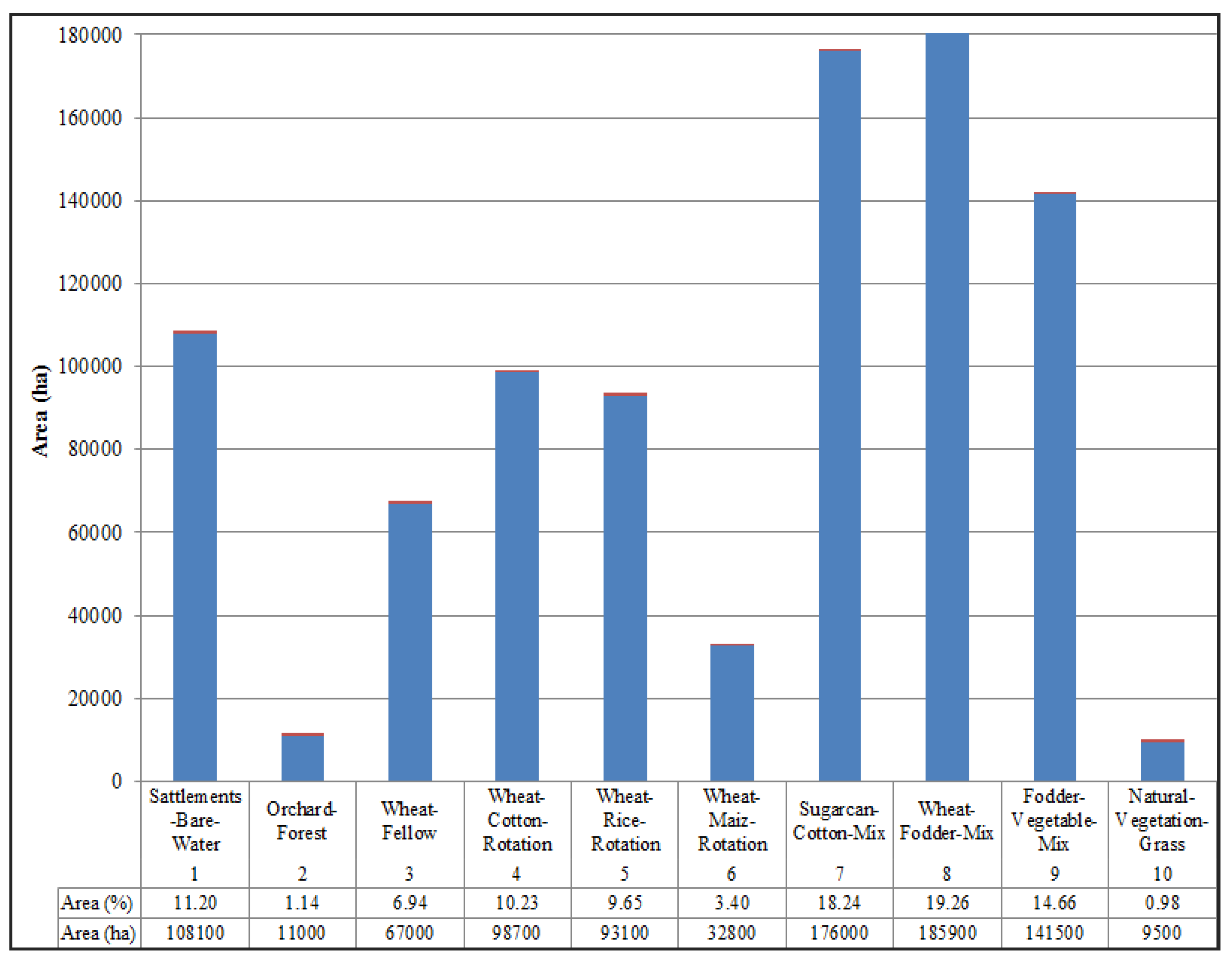

Table 1.
Summary of Remote Sensing satellite data collected for study.
| Data Type | Data Products/ Components | Data Sources | Data Specifications | |
|---|---|---|---|---|
| Remote Sensing Satellite data | MODIS (Land) | MYD13Q1=Aqua MOD13Q1=Terra |
https://wist.echo.nasa.gov/api/ | NDVI 250 m 2 spectral bands |
| Landsat | Landsat5 TM | glovis.usgs.gov | 30 m, 7 spectral bands |
|
| Agriculture crops data | Agricultural census data, cropping patterns, Crop Calendar. | Concerned agricultural departments and organizations | For a year, the whole cropping cycle | |
Table 2.
MODIS land cover products NDVI data type.
| MODIS Aqua and MODIS Terra data types | ||
| Descriptions | MYD13Q1 | MOD13Q1 |
| Acquisition Year (2001) Julian Day (001) Horizontal Tile Vertical Tile Production Version Production Year Production Julian Day Production Time (HH:MM:SS) Temporal Resolution Spatial Resolution Major Content of Product HDF-EOS Format data file |
A2008297 h24 v05 .005 2008 315 064818 16DAY 250m Vegetation Indices(VI) Hdf |
A2008305 h24 v05 .005 2008 327 041157 16DAY 250m Vegetation Indices(VI) Hdf |
Table 3.
Specification of MODIS and Landsat4-5 TM band used in this research.
| Sensor | Bands | Wavelength (µm) | Resolution (m) | Key uses |
|---|---|---|---|---|
| MODIS | Band 1 | 0.62–0.67 | 250 | Land cover and VI |
| Band 2 | 0.84–0.87 | 250 | Land cover and VI | |
| Landsat 4-5 TM | Band 1 | 0.45-0.52 | 30 | Land cover |
| Band 2 | 0.52-0.60 | 30 | Land cover | |
| Band 3 | 0.63-0.69 | 30 | Land cover | |
| Band 4 | 0.76-0.90 | 30 | Land cover | |
| Band 5 | 1.55-1.75 | 30 | Land cover | |
| Band 6 | 10.40-12.50 | 120* (30) | Land Temperature | |
| Band 7 | 2.08-2.35 | 30 | Land cover |
Disclaimer/Publisher’s Note: The statements, opinions and data contained in all publications are solely those of the individual author(s) and contributor(s) and not of MDPI and/or the editor(s). MDPI and/or the editor(s) disclaim responsibility for any injury to people or property resulting from any ideas, methods, instructions or products referred to in the content. |
© 2024 by the authors. Licensee MDPI, Basel, Switzerland. This article is an open access article distributed under the terms and conditions of the Creative Commons Attribution (CC BY) license (http://creativecommons.org/licenses/by/4.0/).
Copyright: This open access article is published under a Creative Commons CC BY 4.0 license, which permit the free download, distribution, and reuse, provided that the author and preprint are cited in any reuse.


