
Submitted:
09 July 2024
Posted:
10 July 2024
You are already at the latest version
Abstract
This article aims to assess Pakistan's National Spatial Data Infrastructure implementation efforts through well-established approaches including the SDI readiness model, organizational aspects, and state of play. The findings underscored challenges related to human resources, SDI education/culture, long-term vision, GI awareness, sustainable funding, metadata availability, online geospatial services, and geospatial standards hindering the NSDI development in Pakistan. However, certain factors, such as the legal framework for NSDI establishment, web connectivity, geospatial software availability, core spatial dataset availability, and institutional leadership, exhibit favorable standings. Thus, to enhance the development of NSDI for Pakistan, recommendations include bolstering financial and human resources, improving online geospatial presence, and fostering a long-term vision for NSDI.
Keywords:
Pakistan
; NSDI
; Sustainable Development
; SDI
; SDI Readiness Index
1. Introduction
Spatial data is a vital input for national planning and development [1]. In other words, this creates a greater demand for numerous advanced tools to extract and utilize it effectively. Spatial Data Infrastructures (SDIs) do it by supporting data sharing and access from different sources being organized into a system. That is why, in many countries, to better consume spatial data, the NSDIs have been envisioned [2]. Moreover, the UN Sustainable Development Goals (SDGs) Agenda 2030 prompts countries to create and utilize spatial data to advance Sustainable Development (SD), which also requires access to standardized spatial data is one of the core functions of an SDI. SDI permits the immediate disclosure of spatial data, which is instrumental for development and resource management.
Implementing SDIs requires institutional frameworks, policies, and technologies to facilitate the accessibility and availability of spatial data and information [3]. It can be viewed as a joint way of ameliorating the process of bringing the spatial data closer to the public, broader distribution, and optimizing the use of funds for overall benefit [4]. Although some countries are using SDI to formulate policies, share geospatial data resources, and tackle some issues related to data access and use, there have been varying degrees of success in these areas. In developed countries, there have been instances of success, whereas underdeveloped nations have encountered significant challenges.
Unstructured data created by governments and private companies in developing countries restricting its use for the improvement of land use and economic development [5]. For example, Tanzania's development efforts are also hindered by the fact that there is poor management of spatial data in the country, making it difficult for people to obtain, share, and use valuable spatial data. The absence of synergy among the organizations significantly affects data collection as well as the sharing of information [6]. Similarly, [7] researched legal documentation associated with spatial data legislation and revealed a plethora of incompatibilities and challenges in implementing NSDI and formulating strong policies in Armenia. [8] examined open data for Polish Spatial Data Infrastructure (PSDI) to create technical tools and engage more stakeholders to participate in the decision-making process. [9] perspectives on the developmental outline of a Marine SDI to contribute to Marine Spatial Planning in Greece. [10] outlined NSDI to guide decision-making for NBS projects involving the integration of social, ecological, environmental, and hydrological data, and health outcomes into flood risk assessments.
To face the challenges and the World dynamism, the effort to promote the development of National Spatial Data Infrastructure in Pakistan has been initiated. Numerous seminars, training, and meetings were organized on spatial data sharing, spatial data integration, and spatial planning [11,12]. Pakistan’s government mandated Survey of Pakistan to establish a National Spatial Data Infrastructure (NSDI) for the country in 2014 to support cooperation among different government agencies [13,14].
Now, a feasibility study is being conducted which is aimed at establishing an NSDI in Pakistan [15,16]. The main objective of this feasibility study is to define and distinguish financial, legal, technical, and human factors to support project implementation. Also, the feasibility study investigates the system for governance, management, financial and business models, and the establishment of the NSDI secretariat. The research on the purpose of the feasibility study is based on the data collected from various sources, such as workshops, social media sites, and meetings, to get a high-level overview of the analysis. Furthermore, COMSATS University Islamabad hosted a workshop, which included all aspects of Pakistan’s National Spatial Data Infrastructure as [15] endorsed. On the other hand, we foresee that the adoption of the NSDI will not only improve the cadastral systems but will straightforwardly provide other benefits. This holds special importance specifically in agricultural policymaking which was brought to light by [17,18].
In addition to ongoing initiatives, Pakistan continues to grapple with challenges in providing a supportive environment for users to access spatial datasets. There is an urgent need to systematically address this issue and evaluate the readiness of Pakistan's NSDI to identify focal points for development and facilitate the NSDI's progress in the nation. [19] contend that the SDI readiness model is particularly applicable in the nascent stages of NSDI development, such as the case of Pakistan's NSDI. Within the framework of the multi-view assessment approach [20,21], the SDI readiness model proves to be an effective technique.
To date, no comprehensive study has been commissioned to assess the status of Pakistan's NSDI systematically. Therefore, the basic research question is how can multi-view assessment methodologies be used to evaluate the current status of Pakistan's NSDI? The study's findings will serve to guide policymakers in directing strategic efforts toward the development and implementation of NSDI initiatives in the country.
2. Literature Review
SDI ensures connectivity of social economic, environmental, and institutional databases in regions, provinces, states, and countries by being a pipeline that serves to connect them [22]. As [23] stated, that being interconnected is the core idea of creating the NSDI as it provides easy access to data sources and useful services to different private sectors, government sectors, and the general public.
In 1999 and 2005, the readiness index was first introduced in Cuba to assess the SDI readiness index and identify deficiencies. The year 2005 was chosen because a geographic data portal at the national level was set up in the same year for spatiotemporal data distribution of users [24]. The authors explained the different SDI readiness model dimensions ranging from its reasons of existence to its development process, among many others. They applied the SDI readiness model in 27 countries worldwide, such as “Argentina, Barbados, Brazil, Canada, Chile, Colombia, Cuba, Denmark, Dominica, Dominican Republic, Ecuador, Grenada, Guyana, Jamaica, Malaysia, Mexico, the Netherlands, Nepal, Norway, Poland, Serbia, St. Lucia, St. Vincent, Spain, Trinidad, and Tobago, Turkey, and Uruguay”. They concluded that these countries encountered numerous developmental challenges with SDIs, providing a deeper insight into the main stakeholders of SDI programs globally.
[25] explored the development of SDI in the Caribbean from different angles such as the SDI readiness model, State of Play as envisioned by [26], and clearinghouse suitability index as introduced by [27]. From the SDI readiness index findings, we note that the development of Spatial Data Infrastructure in the Caribbean is at a very early stage. Even though there is significant variation in SDI progress among the islands due to the reasons of low financial resources or the area, some of the islands have already undergone the process and benefited a lot. Just like the above-mentioned, [28] applied the SDI readiness model, INSPIRE State of Play, and maturity matrix [29] to investigate the SDI situation in Kosovo. In Kosovo, the SDI readiness model was taken in two specific periods (2007 and 2010), where an independent panel composed of ten SDI experts was asked about different factors. This analysis led to an SDI readiness index score of 0.26 in 2007 and 0.36 in 2010, indicating a slight improvement. Furthermore, organizational aspects were emphasized to enhance the success of SDI implementation in Kosovo.
Ethiopian NSDI was assessed by [30] using a multifaceted evaluation framework comprising the SDI readiness scale, the State of Play approach, the clearinghouse suitability index, and organizational factors. The assessment revealed that the overall readiness of the Ethiopian NSDI was 39%, with only the information and organizational components scoring above average. Similarly, [31] scrutinized the adequacy of NSDI for Peru. The review of results showed that a readiness score of 51% was registered for Peru's NSDI. The study also magnified the problems surrounding the functioning of Peru's NSDI like legal agreements, availability of metadata, SDI culture, willingness to share spatial datasets, financial support from the central government, and communication infra. Furthermore, the assessment of geographic information delivery gained a medium score.
[32] subjected the Kenyan NSDI to a multi-view evaluation, in a study that followed the SDI readiness model, Modified State of Play, and organizational aspects. Public and private sectors, academia, NGOs, international entities as well as civil society organizations were involved in the research. Analysis of the results showed that Kenya's NSDI had a preparedness score of 39%, which shows that the spatial data was not available due to the problem of information and communication infrastructure, web connectivity, and the issue of human resources shortage. Inadequate sharing of digital data, lack of financial support over a long period, lack of professionals with geospatial skills, retardation of technology advancement, minimal public awareness, no availability of data metadata, and poor network access are the weaknesses noted for the Kenya NSDI.
[33] investigated the presence or absence of the NSDI in African countries through the SDI readiness index comprising 15 variables by selecting 12 countries. Tanzania, Zimbabwe, Botswana, and Malawi came with low scores while Senegal, Rwanda, South Africa, and Ghana got high scores. A review of the NSDI development process in African countries revealed some of the areas that need development, such as the quality and quantity of human resources and financial resource constraints. [34] investigated the current nationwide status of SDI development in Iran they based their study on the review of literature, and local surveys, as well as the SDI readiness model comprising 16 variables. The results showed that Iran was at 44% of the NSDI readiness level. Comparing the readiness index of Iranian SDI with that of the other countries revealed that the Iranian SDI readiness indicators are less than average, considering the under-developed organizational, human resource, and information factors. According to the research findings, infrastructure development, including the macro-policies, legislation, culture, HR, and Institutions is needed as essential support for Iranian NSDI development.
[35] did a status analysis and an ongoing development analysis of NSDIs in several selected countries, namely, “Botswana, South Africa, Malawi, Zimbabwe, and Tanzania”. The evaluation of the method utilized two multi-view frameworks, namely the organizational evaluation method and the enhanced state-of-play technique. The investigation of synergies has shown that the exchange and integration of data among various stakeholders and departments are obstacles to the carving-out of NSDI in the Republics of Africa. The analysis of spatial data infrastructure indicated that there were areas that were underdeveloped in the chosen countries, and these included, technical infrastructure, regulatory frameworks, strategic policy impacts, national security considerations, and privacy concerns. Technical options for enabling interoperability and data transactions across digital channels in Southern African nations have not yet matured and are at an initial stage, and human and policy-related activities are still in the early stages. The study showed that often even governmental agencies’ prioritization of their mandates in developing countries may discourage the collective efforts to share and distribute spatial infrastructures.
[36] has assessed the Bangladesh NSDI using 14 key variables developed by Eelderink and Crompvoets [37] and reported challenges like limited funding, data sharing reluctance, and lack of human capital. The authors also noted that despite these challenges, Bangladesh has made progress through investments in data availability, institutional leadership by the Survey of Bangladesh, and initiatives to raise awareness.
3. Materials and Methods
Spatial Data Infrastructure is a multifaceted, complicated, and dynamic concept. Assessment of SDI using a linear approach may not produce quality results. Therefore, the multi-view framework that combines many approaches may be an appropriate method to assess NSDIs. The methodology used in this article is based on the Multiview assessment approaches (SDI readiness index, organizational aspects, and state of play) as envisaged by [38]. The SDI-readiness model was selected because it is best suited in a situation where NSDI development is in its early stages [19] as NSDI development in Pakistan is at its initial stages as well. State of play and organizational approaches are selected to explore the in-depth status of NSDI in Pakistan. The proceeding sections underscore a brief overview of each approach.
3.1. SDI Readiness Approach
The SDI readiness index developed by Delgado Fernández [24] represents an integrated evaluation of countries' capacities and strengths in implementing SDIs. By employing the SDI readiness model, policymakers can delve into critical aspects of SDI assessments, aiding in the formulation of effective policies for national SDI development, implementation, maintenance, and enhancement. [24] argued that the SDI readiness model facilitates the identification of SDIs' primary strengths and weaknesses, enabling comparative analysis of SDI readiness indices across countries or initiatives.
This index encompasses 16 factors grouped into five indices: technological, organizational, informational, financial, and human resources (Table 1). The organizational index comprises three key factors: political dedication to the SDI vision, institutional leadership for SDI, and establishment of legal frameworks. Political commitment is pivotal for recognizing NSDI's role in evidence-based policymaking and project oversight. Institutional leadership entails collaboration among national-level SDI-related bodies, while the legal framework concentrates on setting up pertinent legal instruments at the national level.
The informational index comprises metadata availability for geospatial data and core geospatial dataset availability. The human resources index is composed of human capital, SDI-related education, and culture, as well as individual leadership. The indicator for human capital score is derived from the UN E-Government Survey (2022), while the education/culture aspect pertains to capacity building and awareness campaigns regarding geospatial data utilization. Individual leadership denotes the capability to implement SDI-related agendas.
The financial resources index encompasses public-sector, private-sector funding, and cost recovery models. Adequate funding is indispensable for SDI initiative development. Funds can be earmarked for capacity building, data collection, metadata preparation, as well as management responsibilities. The technological index is made up of data access networks and technologies that deliver data sharing and digital services. This is made up of telecommunication infrastructure, internet connectivity, the availability of indigenous/commercial geospatial software, and the application of open resources. The telecommunication infrastructure and web connectivity indexes are fetched from the UN E-Government Survey (2022).
Given the qualitative nature of most factors, the readiness model utilizes compensatory fuzzy logic for calculation. Thirteen indicators' values are determined through surveys with SDI and GIS experts, while three indicators' values are sourced from the UN E-Government Survey (2022). Further details regarding indicators and factors are provided in Table 1.
In the readiness model, the overall score is calculated based on the formula presented by the authors in [24].
where the compensatory logic is applied, the conjunction is solved by
and the disjunction by
SDI readiness = (Ov ^ Ol ^ Oa) ^ (Ic ^ Im)^ (Pc ^ Pc ^ Pl ) ^ (Fg v Fp v Fr) ^ (At ^ Aw ^ (As v Ad v Ao)) 0.5
c(x1, x2, . . . , xn) = (x2, . . . , xn) (1/n)
d(x1, x2, . . . , xn) = 1 − ((1 − x2)∗(1 − x2) . . . (1 − xn))(1/n)
Finally, the following expression calculates the SDI readiness score:
SDI readiness = (Ov∗Ol∗Oa) (1/3)∗ (Ic∗Im) (1/2) ∗(Pc∗Ps∗Pl) (1/3) ∗ (1 − ((1 − Fg) ∗ (1 − Fp)∗(1 − Fr) (1/3)
∗ ((At∗Aw ∗(1 − ((1 − As)∗(1 − Ad ) ∗ (1 − Ao)) (1/3))) (1/3)) (1/2)
∗ ((At∗Aw ∗(1 − ((1 − As)∗(1 − Ad ) ∗ (1 − Ao)) (1/3))) (1/3)) (1/2)
To calculate the indicator scores, the experts' survey included a questionnaire with 13 questions. Each question provided seven response options: "extremely high, very high, high, medium, low, very low, and extremely low.". To assess each indicator, a weight was assigned to each option. Table 2 shows the weights assigned to each option.
3.2. Organizational Approach
[29] presented an organizational framework for evaluating the status of NSDI. This framework, as outlined by [21], assesses SDI's status and progress using six organizational-specific parameters: vision, leadership, communication, self-organizational ability, awareness, and financial suitability. These parameters are further broken down into 12 sub-indicators, each evaluated on a binary scale of yes or no. The cumulative responses for each main indicator are then tabulated, as depicted in Table 3, detailing both the main indicators and their corresponding sub-indicators within the organizational approach.
3.3 Modified State of Play
The State of Play approach, initially tailored for monitoring and analyzing NSDI-related endeavours primarily within European nations [28], encompasses various parameters for assessing SDI. These parameters include organization, personnel, policy framework, data and metadata management, access services for data/metadata, adherence to relevant standards, and thematic environmental data integration. While initially conceived for European contexts, studies indicate its applicability beyond Europe [30,32,35].
[39] implemented the State of Play approach by gathering data from country reports, websites, and expert interviews. A modified version, derived from the INSPIRE State of Play approach within the multi-view assessment framework, was adopted. This adaptation expanded to include 26 indicators, categorized according to SDI components: personnel, policy, data management, technology, and standards, as delineated in Table 4.
3.4. Data Collection
Data for the assessment methodologies were collected in 2023 from 20 experts having experience in SDI and GIS, through questionnaire-based interviews and surveys. These experts were intentionally selected from diverse backgrounds, including public and private sectors, as well as academia. Qualifications for expert selection included operational and managerial-level experience and expertise in SDI and GIS related fields, along with a willingness to engage in the survey.
The expert selection proved challenging because NSDI in Pakistan is still in infancy and only limited professionals have some knowledge of SDI-related concepts. Following the survey, data analysis utilized a formula recommended by [38]. This involved assigning weights to respondents' answers according to measures outlined in Table 2. Subsequently, calculations were conducted for various SDI readiness factors and indices to gain insights into Pakistan's SDI preparedness. The data calculation process involved several steps:
- Each survey/interview response was assigned a weight based on the measures specified in Table 2;
- Values for different SDI readiness factors—such as information infrastructure, technology infrastructure, financial resources, organizational infrastructure, and human resources—were estimated using formulas from the SDI readiness model. The calculated values for these factors represent the geometric mean of scores derived from each factor's specific formula. For instance, the information factor's value was estimated using the formula (Ic ∗I Im) (1/2), where Ic and Im denote criteria scores relating to core spatial dataset availability and metadata availability, respectively.
- For each answer, the overall SDI readiness index was calculated, by computing the geometric mean of the factors.
- Finally, the overall score of Pakistan’s NSDI was the geometrical mean of the indices obtained for response to each question. To make the calculation easy, fast, and accurate, all the involved steps in the calculation were executed using built-in functions of the Microsoft Excel software.
4. Results
The subsequent sections described the outcomes of the analysis based on different approaches for the assessment of the NSDI of Pakistan.
4.1. SDI Readiness Approach
SDI readiness approach employs a readiness model utilizing five indices. The results for each index, as well as the overall index, are presented below.
4.1.1. Organization Index
The organization matrix consists of indicators like the politicians' knowledge about SDI, institutional guidance, and legal systems. In this research, the total value of the organizational factor index for Pakistan's SDI was measured as 0. 37. The politicians' vision of SDI, leadership in the institutions, and legal aspects were all scored as 0.21, 0.58, and 0.42 respectively. This data suggests that vision from the institutional leadership came out as the highest, while vision from politicians reported the lowest score.
4.1.2. Information Index
The information base (the information index) includes indicators such as metadata availability, in addition, the spatial datasets like administrative boundaries, elevation, local names, cadastral parcels, transportation, aerial photography, and satellite images are also part of this. These principles were the pre-conditions on the information factor index of SDI of Pakistan which was 0. 36. Spatial data and metadata indicators were rated at 0.56 and 0.23 respectively. These results indicate a low overall score for the information index, where both components have values below 0.5.
4.1.3. Human Resources Index
The human resources index is anchored by the human capital index, education relating to the SDI, and leadership at an individual level. The factor index of the human resources factor for the case study of SDI is 0.25 for Pakistan. The chosen indicators to assess the human capital index, SDI education and the best practices of individual leadership scored 0.39, 0.32, and 0.13 respectively. These results reflect a low score of less than 0.5 across all indicators.
4.1.4. Technology Index
Technology infrastructure is among the most significant aspects in making geospatial data and services in the SDI architecture reachable and available. The technology infrastructure index comprises five indicators: such as the telecommunication infrastructure, the technology of the web, the availability of commercial geospatial software, the technology created by the indigenous informational development, and the culture of open-source technologies in SDI. In this study, we have estimated the technological infrastructure index of SDI of Pakistan at 0.66. The result obtained showed that the leading index was web connectivity, and the trailing one was the availability of geospatial software.
4.1.5. Financial Index
The indicator of financial resources being strong is very important for SDI progress in every country. The financial resources index includes elements like shared funding schemes, grant-making from the private sector, and cost recovery measures. These indicators form the basis for calculating the financial resources factor index for Pakistan's SDI which is 0.16. The marks for public-sector funding, pricing acts, and private-sector funding were 0.20, 0.15, and 0.11 respectively.
4.1.6. Overall Index
SDI readiness model developed by Delgado-Fernández et al. (2005), suggests that a country is nationally ready to adopt SDI infrastructure when it scores well in various parameters including but not limited to the level of organization, information, human resources, financial resources, and technology. The aggregate index of all indices to reveal Pakistan’s SDI readiness was computed to be 0. 32 which shows that Pakistan has to do a lot to succeed in the process of establishing NSDI. Figure 1 depicts the overall Pakistan SDI readiness score rated along with the scores of separate indices.
As depicted in Figure 1, the scores for the information and organization factors were similar to the overall readiness index score. Among the factors, technology had the highest score, while financial resources had the lowest. Figure 2 provides a detailed breakdown of the scores.
Based on the 16 indicators, the results shown that for private-sector funding and web connectivity the scores were the lowest and the highest respectively. Additionally, it was evident from the indicator rankings that 12 out of 16 indicators scored less than 50%, compared to the 100% benchmark for full readiness.
Organizational Approach
The organizational approach involved six indicators and 12 sub-indicators to assess various aspects: In the leadership indicator, both sub-indicators received agreement from the majority of respondents (90%). For inclusiveness & communication channels, there were disagreements by the majority (75%), with one sub-indicator showing more agreement than the other regarding the existence of a commitment platform for Pakistan’s NSDI. The long-term vision indicator showed the highest disagreement (92% of respondents) across all three sub-indicators. In terms of self-organizing ability, while 60% of respondents agreed overall, one sub-indicator had 20% more agreement than the other. Regarding GI awareness, 70% of respondents expressed disagreement, with one sub-indicator showing 20% more disagreement than the other. The sustainable funding indicator had only one sub-indicator, with the majority (90%) of respondents showing disagreement. Figure 3 presents the cumulative results of the indicators for the organizational approach.
State of Play Approach
The state-of-play approach employed five indicators with 26 sub-indicators for assessment. The people indicator included six sub-indicators. While 19% fully agreed and 28% partially agreed with the statements, 33% were unaware of information availability. For the policy indicator, more than 50% stated information unavailability. Particularly, 90% were unaware of the existence of a data-sharing policy framework or strategy. No one fully agreed to four sub-indicators, while 15% fully agreed to one. 30% disagreed and 13% partially agreed with the statements for this indicator. The data indicator comprised four sub-indicators. 36% disagreed, 24% partially agreed, and 11% fully agreed with the statements. One sub-indicator showed 30% more disagreement than others.
In the technology indicator, the majority (91%) disagreed with the statements, with two sub-indicators showing 100% disagreement. No respondents fully or partially agreed. The standards indicator consisted of two sub-indicators, with 70% expressing disagreement with the statements. Figure 4 presents the results of indicators and sub-indicators.
5. Discussion
This research presents the first-ever systematic assessment of Pakistan's NSDI development status using multi-view assessment approaches, including the SDI readiness model, organization aspects, and the state of play.
5.1. SDI Readiness Approach
SDI readiness encompasses five factors: organizational infrastructure, information infrastructure, technology infrastructure, human resources, and financial resources.
The organizational infrastructure received a low score (0.37) primarily due to subpar performance in key indicators, including politicians’ vision of SDI. To elevate this factor's score, it's imperative to enhance politicians' understanding and commitment to NSDI, making it a top priority for development. Additionally, improving the legal framework is crucial, alongside robust SDI awareness campaigns targeting higher-level politicians and governmental bodies. In short, the low scores in organizational indicators can pose a significant obstacle to the effective implementation of NSDI in Pakistan.
The information infrastructure factor scored lower primarily due to the limited availability of metadata indicators. However, the availability of core spatial dataset indicators performed better, scoring at 0.58. This higher score reflects the availability of numerous geospatial datasets that can be shared with users via web connectivity. Nonetheless, data sharing may be constrained by low scores in various indicators, including metadata availability, absence of a geoportal for online services, lack of data sharing policies, and insufficient indigenous geospatial software development. The low score for metadata availability indicates inadequate preparation of metadata requirements within Pakistan’s SDI development context. To enhance information factors, Pakistan should increase awareness about the importance of spatial data and metadata for national-level planning and development. By standardizing metadata practices, building local capacity, developing user-friendly tools and incentivizing metadata creation spatial data management capabilities can be enhanced. A robust SDI with high-quality metadata can drive sustainable development, informed decision-making, and efficient resource management, ultimately contributing to economic growth and improved quality of life. Additionally, fostering collaboration between public and private sector organizations and enhancing policy, legal, and organizational frameworks are crucial steps that can be taken for the successful implementation of NSDI in Pakistan.
The human resources factor also exhibited lower scores, primarily due to the inadequate performance of indicators such as culture/education regarding SDI and individual leadership. While the human capital indicator scored relatively higher, likely influenced by investments to increase adult literacy rates and gross enrollment ratios, it remains notably higher than the other two indicators. The low score for culture and education regarding SDI underscores insufficient investment in societal capacity building concerning spatial data's significance and its societal impact. Moreover, the low score for individual leadership highlights leaders' weak capacity to collaborate across organizational boundaries. To address these challenges, stimulating activities should be employed to foster a collaborative culture and motivate individuals toward common goals. Hence, investing in enhancing this factor is imperative to bolster NSDI development in Pakistan.
The financial resources factor attained the lowest score among all five factors. This is primarily attributed to the low values of all three indicators: governmental funding, private sector funding, and cost recovery. Particularly, the private sector funding indicator scored lower compared to the other two indicators in this factor. This can be attributed to the inadequate investment opportunities available for the private sector. In short, the limited financial resources allocated to Pakistan’s SDI development hinder the progress of SDI development in the country.
The technology infrastructure factor exhibited a relatively high score among all factors within the SDI readiness model. This heightened score can be primarily attributed to the strong performance of two indicators: web connectivity and availability of geospatial software. However, other indicators such as telecommunication infrastructure, native development of geospatial software, and utilization of open-sourced resources obtained relatively low scores. The robust score of the web connectivity indicator indicates extensive use of information and communication technologies (ICTs), as well as a prevalent culture of mobile and web applications for service delivery. Similarly, the high score in the availability of geospatial software indicators suggests advancements in developing and implementing effective policies and guidelines to leverage GIS technologies effectively in the country. This also signifies a growing trend in the utilization of location-based services by various stakeholders, including public and private sector organizations as well as academia. Conversely, limited awareness campaigns promoting the use of open data resources, easy access to proprietary software solutions at minimal costs, and inadequate awareness of relevant copyright laws contributed to the low score in the culture of use of open-source resources indicator.
Four out of five factors within the SDI readiness model, namely organizational infrastructure, financial resources, human resources, and information infrastructure, fall short of the required standards for NSDI development in the country. Hence, it is imperative to undertake appropriate actions to enhance the status of these factors, as improvement in these areas is crucial for the success of NSDI in Pakistan. This observation is supported by findings from studies conducted by [34,40,41,42].
5.2. Organizational Approach
The organizational approach encompasses six indicators: leadership, inclusiveness & communication channels, long-term vision, self-organizing ability, GI awareness, and sustainable funding. In terms of leadership establishment for NSDI, 90% of respondents agreed, likely influenced by the legal mandate outlined in the Surveying and Mapping Act 2014 by the Government of Pakistan [43]. However, concerning the existence of a long-term vision for NSDI, 92% disagreed. This discrepancy stems from the lack of progress despite the enactment of relevant legislation in 2014; NSDI has not been prioritized by the Government of Pakistan. Overall, the organizational aspects indicate relatively high levels of leadership and self-organizing ability, but a lack of long-term vision and sustainable funding.
5.3. State of Play Approach
The modified state-of-play approach assesses five indicators: people, policy, data, technology, and standards. In terms of standards and technology indicators, most respondents expressed disagreements. This is primarily attributed to the absence of a geoportal in the country, which hampers online data download or access services. Additionally, there is a lack of comprehensive documents regarding standards. More than 50% of respondents were unaware of existing policy documents, indicating that these documents are organization-specific and not readily accessible to the broader community or external organizations. Overall, the state of play indicates relatively high scores for people and data, while technology and standards exhibit lower scores.
6. Conclusions
The assessment of NSDI development for Pakistan using multi-view approaches such as the SDI readiness model, organizational, and state of play revealed a lack of basic requirements necessary for its true development. This is evidenced by the low scoring (less than 0.5) of 12 out of 16 indicators across various domains, including governmental and private sector funding, ICT infrastructure, individual leadership, legal framework, politicians' vision regarding SDI, availability of relevant metadata, SDI-related education, cost recovery mechanisms, indigenous geoinformation development, culture of open-source resource utilization, and human capital. While the SDI readiness model offers valuable insights into the NSDI's status for the country [21], it does not inherently provide solutions for addressing the low scores observed in some factors. These insights serve to highlight the associated challenges and weaknesses in NSDI development. Additionally, within the organizational approach, respondents exhibited disagreement regarding long-term vision, sustainable funding, inclusiveness & communication channels, and GI awareness. Similarly, the state-of-play period also witnessed different opinions from the respondents on the two matters of technology and standards. The insights show that it is a multilevel problem in improving the status of NSDI in Pakistan.
In light of the findings, the Survey of Pakistan could be designated as the main holding, coordinator, and facilitator of NSDI in the nation as specified in Clause 15 of the Surveying and Mapping Act 2014 [43]. The Survey of Pakistan could play a pivotal role in addressing the challenges identified in Pakistan's NSDI development, as highlighted in the results, through the following approaches:
- A strong coordination and administrative body be formed for SDI in conjunction with key players in the private and public sectors as is stated in articles 15 of the Surveying and Mapping Act 2014 [43]. This body shall create links with concerned public and private sector bodies and seek changes to the regulatory procedure having crucial considerations for the national spatial development.
- Promotion of awareness programs about the benefits of NSDI among politicians, the government, and the private sector for the sake of creating supporters and ensuring suitable comprehension of NSDI.
- Establish common guidelines, standards, and techniques to make the deployment of NSDI effective, thus the systems and devices in different platforms will be consistent and interoperable.
- Promotion of private-sector involvement such as public-private partnerships (PPP) [44] or other suitable instruments, which can employ private-sector problem-solving abilities and resources to speed up progress.
- Setting up stable financial resources for NSDI because of providing geospatial data necessary for the continuity of important projects including NSDI initiatives. Projects like the formation of a new geodetic datum by the country and a couple of the China-Pakistan Economic Corridor (CPEC) projects can be attached to supplement the progress of NSDI development in Pakistan.
NSDI development in Pakistan needs continuous upgrades on all components to be able to overcome the restrictive aspects, which have been mentioned above. The absence of an established NSDI created problems with the identification of specialists in the area of SDI. Several experts, both in the public and private sector, lacked sufficient experience and a proper understanding of spatial data infrastructure (SDI) principles such as metadata and geoportals which made it hard to determine unbiased stances on NSDI readiness.
Author Contributions
Conceptualization, Munir Ahmad and Asmat Ali; Formal analysis, Munir Ahmad; Investigation, Munir Ahmad; Methodology, Munir Ahmad; Software, Munir Ahmad and Hammad Hussain; Visualization, Munir Ahmad and Hammad Hussain; Resources, Munir Ahmad; Writing— original draft, Munir Ahmad; writing—review and editing, Munir Ahmad and Asmat Ali; supervision, Asmat Ali.; project administration, Munir Ahmad, Asmat Ali and Muhammad Nawaz, Farha Sattar. Critical review and editing, Farha Sattar and Muhammad Nawaz. All authors have read and agreed to the published version of the manuscript.
Funding
This research received no external funding
Informed Consent Statement
Not applicable.
Data Availability Statement
Data sharing does not apply to this article.
Acknowledgments
We acknowledge the support of SDI and GIS experts who contributed their valuable input to the assessment of NSDI in Pakistan.
Conflicts of Interest
The authors declare no conflicts of interest.
References
- UN-GGIM Virtual Regional Seminar on Operationalizing the Integrated Geospatial Information Framework in Asia and the Pacific 2020, 1–6.
- Williamson, I. National SDI Initiatives. In Developing Spatial Data Infrastructures; 2003.
- Diaz, L.; Remke, A.; Kauppinen, T.; Degbelo, A.; Foerster, T.; Stasch, C.; Rieke, M.; Schaeffer, B.; Baranski, B.; Bröring, A.; et al. Future SDI - Impulses from Geoinformatics Research and IT Trends. International Journal of Spatial Data Infrastructures Research 2012, 7. [Google Scholar] [CrossRef]
- Cetl, V.; Ivić, S.M.; Tomić, H. Improvement of National Spatial Data Infrastructure as a Public Project of Permanent Character. Kartografija i Geoinformacije 2009, 8. [Google Scholar]
- Piyasena, N.M.P.M.; Vithanage, P.A.D.V.; Witharana, S.L. A Review of Sri Lanka’s National Spatial Data Infrastructure (SL-NSDI) with the Aim of Enhancing Its Functionalities. In Geospatial Science for Smart Land Management: An Asian Context; 2023.
- Ngereja, Z.R. The Need for Spatial Data Infrastructure for Sustainable Development in Tanzania. African Journal of Land Policy and Geospatial Sciences 2021, 4, 718–729. [Google Scholar]
- Efendyan, P.; Petrosyan, M. Legal Aspects of National Spatial Data Infrastructure of Republic of Armenia. Modern Achievements of Geodesic Science and Industry 2023, 1, 132–134. [Google Scholar] [CrossRef]
- Izdebski, W.; Zwirowicz-Rutkowska, A.; Nowak da Costa, J. Open Data in Spatial Data Infrastructure: The Practices and Experiences of Poland. Int J Digit Earth 2021, 14. [Google Scholar] [CrossRef]
- Vaitis, M.; Kopsachilis, V.; Tataris, G.; Michalakis, V.I.; Pavlogeorgatos, G. The Development of a Spatial Data Infrastructure to Support Marine Spatial Planning in Greece. Ocean Coast Manag 2022, 218. [Google Scholar] [CrossRef]
- Castro, C. V.; Rifai, H.S. Development and Assessment of a Web-Based National Spatial Data Infrastructure for Nature-Based Solutions and Their Social, Hydrological, Ecological, and Environmental Co-Benefits. Sustainability 2021, 13. [Google Scholar] [CrossRef]
- Asmal Ali and Munir Ahmad Geospatial Data Sharing in Pakistan: Possibilities and Problems. In Proceedings of the GSDI 14 world conference; Addis Ababa, Ethiopia, 2013.
- Ali, A. Assessing Readiness for National Geospatial Data Clearinghouse-A Milestone for Sdi Development in Pakistan. In Proceedings of the ICAST 2008: Proceedings of 2nd International Conference on Advances in Space Technologies - Space in the Service of Mankind; 2008; pp. 85–90. [Google Scholar]
- Ali, A.; Imran, M.; Jabeen, M.; Ali, Z.; Mahmood, S.A. Factors Influencing Integrated Information Management: Spatial Data Infrastructure in Pakistan. Information Development 2021. [Google Scholar] [CrossRef]
- Ahmad, M.; Khayal, M.S.H.; Tahir, A. Analysis of Factors Affecting Adoption of Volunteered Geographic Information in the Context of National Spatial Data Infrastructure. ISPRS Int J Geoinf 2022, 11. [Google Scholar] [CrossRef]
- Ahmad, M.; Ali, A.; Mobo, F.D.; Hussain, H. Spatial Data Infrastructure for Information Governance: The Case Study From Pakistan. In Creating and Sustaining an Information Governance Program; Helge, K., Rookey, C.A., Eds.; IGI Global, 2024; pp. 203–216 ISBN 9798369304747.
- Ahmad, M.; Ali, A. A Review of Governance Frameworks for National Spatial Data Infrastructure. In Innovation, Strategy, and Transformation Frameworks for the Modern Enterprise; Correia, A., B. Agua, P., Eds.; IGI Global, 2023; pp. 186–207 ISBN 9798369304594.
- Ali, A.; Imran, M. National Spatial Data Infrastructure vs. Cadastre System for Economic Development: Evidence from Pakistan. Land (Basel) 2021, 10, 188. [Google Scholar] [CrossRef]
- Ali, A.; Ahmad, M.; Nawaz, M.; Sattar, F. Spatial Data Infrastructure as the Means to Assemble Geographic Information Necessary for Effective Agricultural Policies in Pakistan. Information Development 2024, 02666669241244503. [Google Scholar] [CrossRef]
- Giff, G.; Jackson, J. Towards An Online Self-Assessment Methodology for SDIs. In Spatial Enablement in Support of Economic Development and Poverty Reduction; 2013.
- Grus, L.; Crompvoets, J.; Bregt, A.; van Loenen, B.; Fernandez, T.D. Applying the Multi-View Spatial Data Infrastructure Assessment Framework in Several American Countries and The Netherlands. In A Multi-View Framework to Assess SDIs; 2008 ISBN 978-0-7325-1623-9.
- Grus, Ł. Assessing Spatial Data Infrastructures, Delft, the Netherlands: NCG, 2010.
- Coleman, D.J.; Nebert, D.D. Building a North American Spatial Data Infrastructure. Cartogr Geogr Inf Sci 1998, 25. [Google Scholar] [CrossRef]
- McLaughlin, J.; Nichols, S. Developing a National Spatial Data Infrastructure. Journal of Surveying Engineering 1994, 120, 62–76. [Google Scholar] [CrossRef]
- Delgado Fernández, T.; Fernández, M.D.; Andrade, R.E. The Spatial Data Infrastructure Readiness Model and Its Worldwide Application. A Multi-View Framework to Assess SDIs, 2008. [Google Scholar]
- Fernández, T.D.; Crompvoets, J. Evaluating Spatial Data Infrastructures in the Caribbean for Sustainable Development. GSDI-10 Conference, Small Island Perspectives on Global Challenges: The role of Spatial data in supporting a sustainable future, 2008. [Google Scholar]
- Vandenbroucke, D.; Zambon, M.; Crompvoets, J.; Dufourmont, H. INSPIRE Directive: Specific Requirements to Monitor Its Implementation. In A Multi-view Framework to Assess Spatial Data Infrastructures; 2008 ISBN 978-0-7325-1623-9.
- Crompvoets, J. National Spatial Data Clearinghouses, Worldwide Development and Impact, Wageningen University, the Netherlands., 2006.
- Nushi, B.; Loenen, B. van; Besemer, J.; Crompvoets, J. Multi-View SDI Assessment of Kosovo (2007-2010) - Developing a Solid Base to Support SDI Strategy Development. In Spatially Enabling Government, Industry and Citizens - Research and Development Perspectives; 2012.
- Kok, B.; van Loenen, B. How to Assess the Success of National Spatial Data Infrastructures? Comput Environ Urban Syst 2005, 29, 699–717. [Google Scholar] [CrossRef]
- Gemeda, D. Assessing the Development of Ethiopian National Spatial Data Infrastructure, Wageningen University, 2012.
- Pinsonnault, R. Toward a User-Centric Peru Spatial Data Infrastructure Based on Free and Open Source Software, Vrije Universiteit, Amsterdam, the Netherlands., 2013.
- Okuku, J.; Grus, L. Assessing the Development of Kenya National Spatial Data Infrastructure (KNSDI). South African Journal of Geomatics 2014. [Google Scholar]
- Mwange, C.; Mulaku, G.C.; Siriba, D.N. Reviewing the Status of National Spatial Data Infrastructures in Africa. Survey Review 2018. [Google Scholar] [CrossRef]
- Kalantari Oskouei, A.; Modiri, M.; Alesheikh, A.; Hosnavi, R.; Nekooie, M.A. An Analysis of the National Spatial Data Infrastructure of Iran. Survey Review 2019, 51. [Google Scholar] [CrossRef]
- Ogunbiyi, J. Reviewing the Status of National Spatial Data Infrastructure: A Case Study in Southern African Countries, Wien, 2021.
- Rahman, Md.M.; Szabó, G. Assessing the Status of National Spatial Data Infrastructure (NSDI) of Bangladesh. ISPRS Int J Geoinf 2023, 12. [Google Scholar] [CrossRef]
- Eelderink, L.; Crompvoets, J.; de Man, E. Towards Key Variables to Assess National Spatial Data Infrastructures (NSDIs) in Developing Countries. A Multi-View Framework to Assess SDIs, 2008, 307–325.
- Delgado-Fernández, T.; Lance, K.; Buck, M.; Onsrud, H. Assessing an SDI Readiness Index. In Proceedings of the FIG Working Week and GSDI-8; 2005; pp. 1–10. [Google Scholar]
- Grus, L.; Crompvoets, J.; Bregt, A.; van Loenen, B.; Fernandez, T.D. Applying the Multi-View Spatial Data Infrastructure Assessment Framework in Several American Countries and The Netherlands. In A Multi-View Framework to Assess SDIs; 2008 ISBN 978-0-7325-1623-9.
- Mohammadi, H.; Associate Professor, A.R. The Integration of Multi-Source Spatial Datasets in the Context of SDI Initiatives. Department of Geomatics, School of Engineering, Centre for SDI and Land Administration, 2008. [Google Scholar]
- McDougall, K.; Professor Iams Williamson and Dr, A.R. A Local-State Government Spatial Data Sharing Partnership Model to Facilitate SDI Development. Department of Geomatics, School of Engineering, Centre for SDI and Land Administration, 2006. [Google Scholar]
- de Man, E. Spatial Data Infrastructuring: Praxis between Dilemmas. International Journal of Spatial Data Infrastructures Research 2011. [Google Scholar] [CrossRef]
- GoP Surveying and Mapping Act; National Assembly of Pakistan: Islamabad, 2014.
- Asmat, A. Potential of Public-Private Partnership for NSDI Implementation in Pakistan, MSc Thesis, ITC: Enschede, Netherlands, 2008. [Google Scholar]
- Crompvoets, J.; Rajabifard, A.; van Loenen, B.; Delgado Fernández, T. A Multi-View Framework to Assess SDIs, 2008.
Figure 1.
Score of Pakistan’s NSDI Readiness Indices.
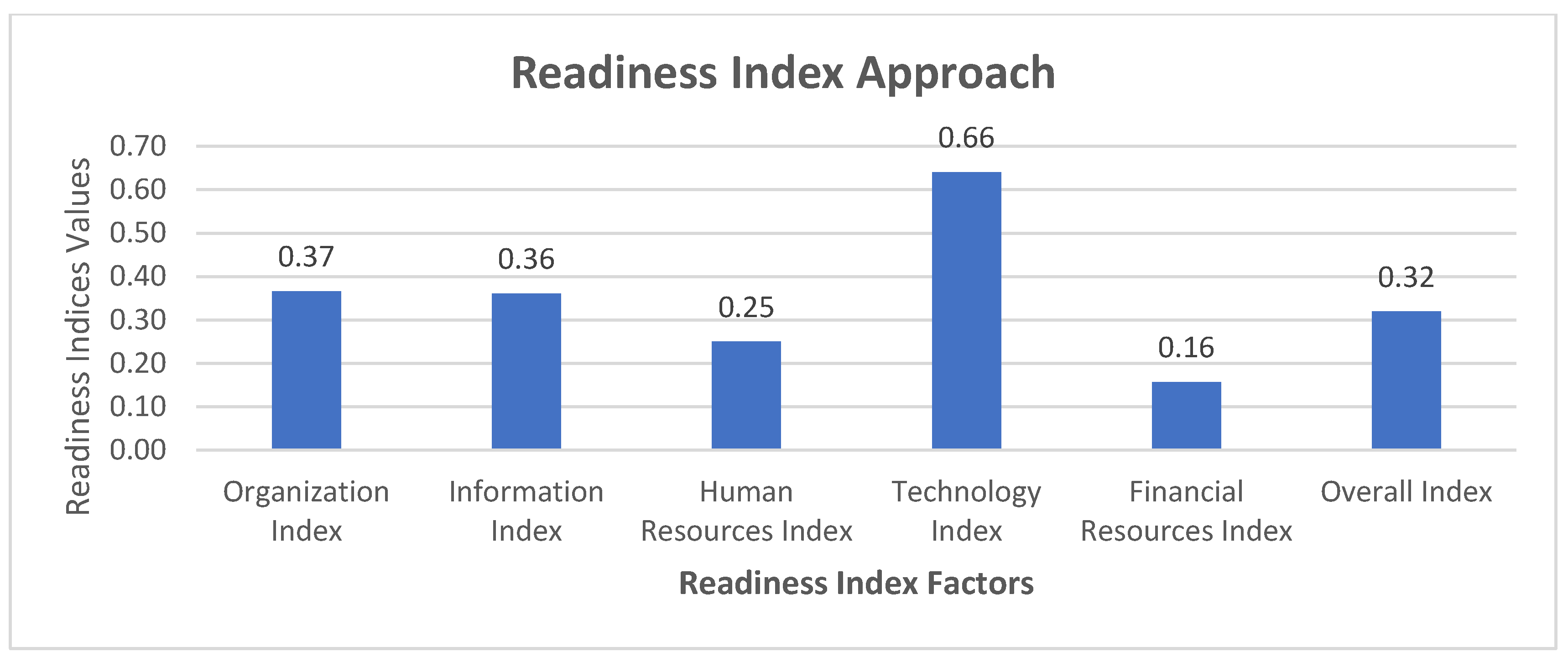
Figure 2.
Score of Pakistan’s NSDI Readiness Indicators.
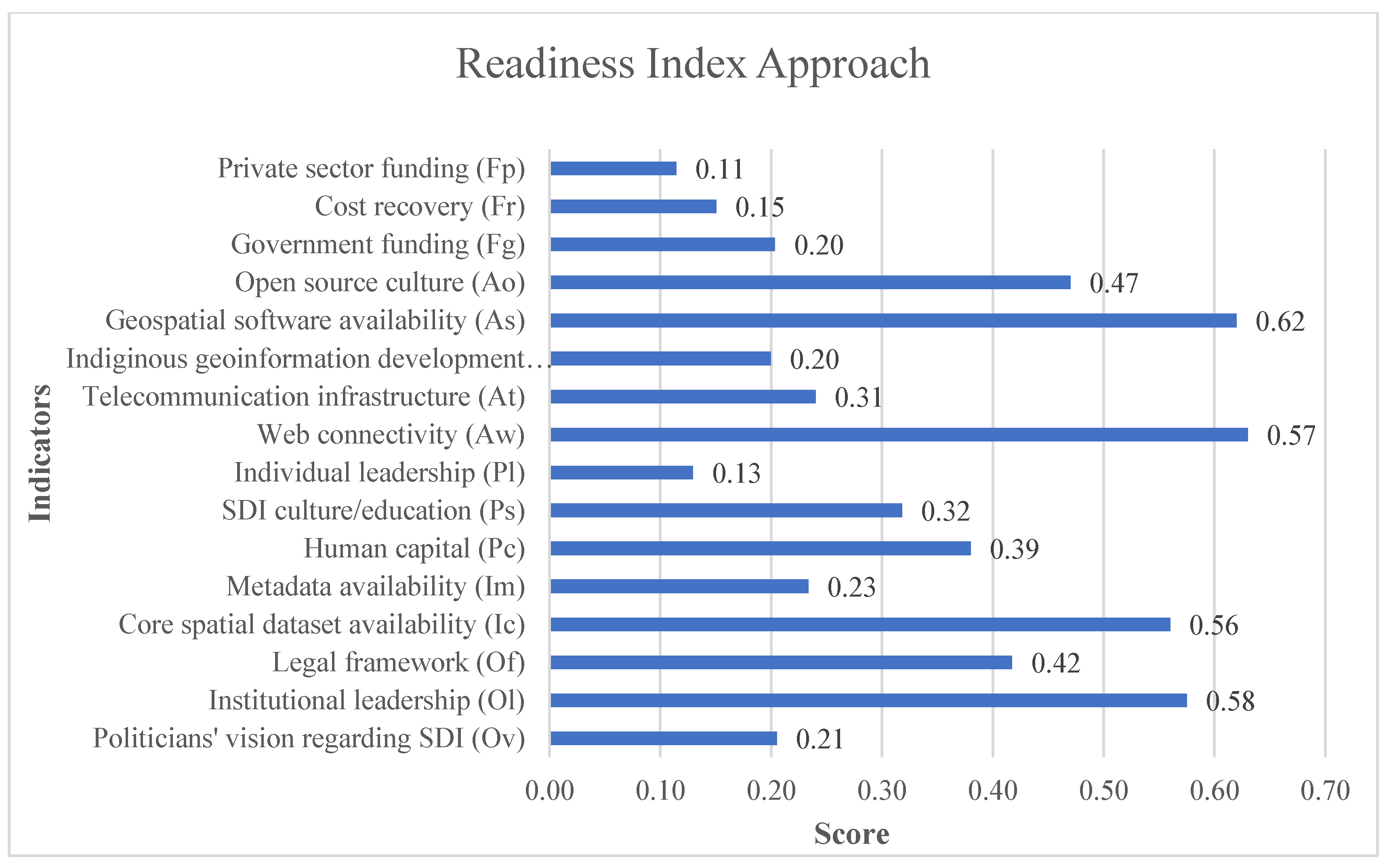
Figure 3.
Score of Pakistan’s NSDI Readiness Indicators.
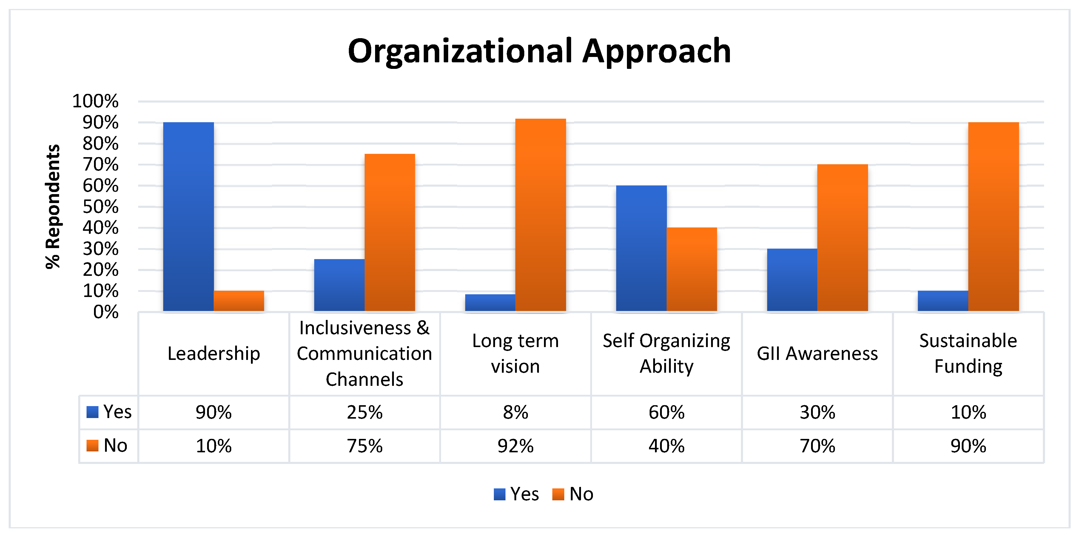
Figure 4.
Summarized results of 05 indicators of the state-of-play approach.
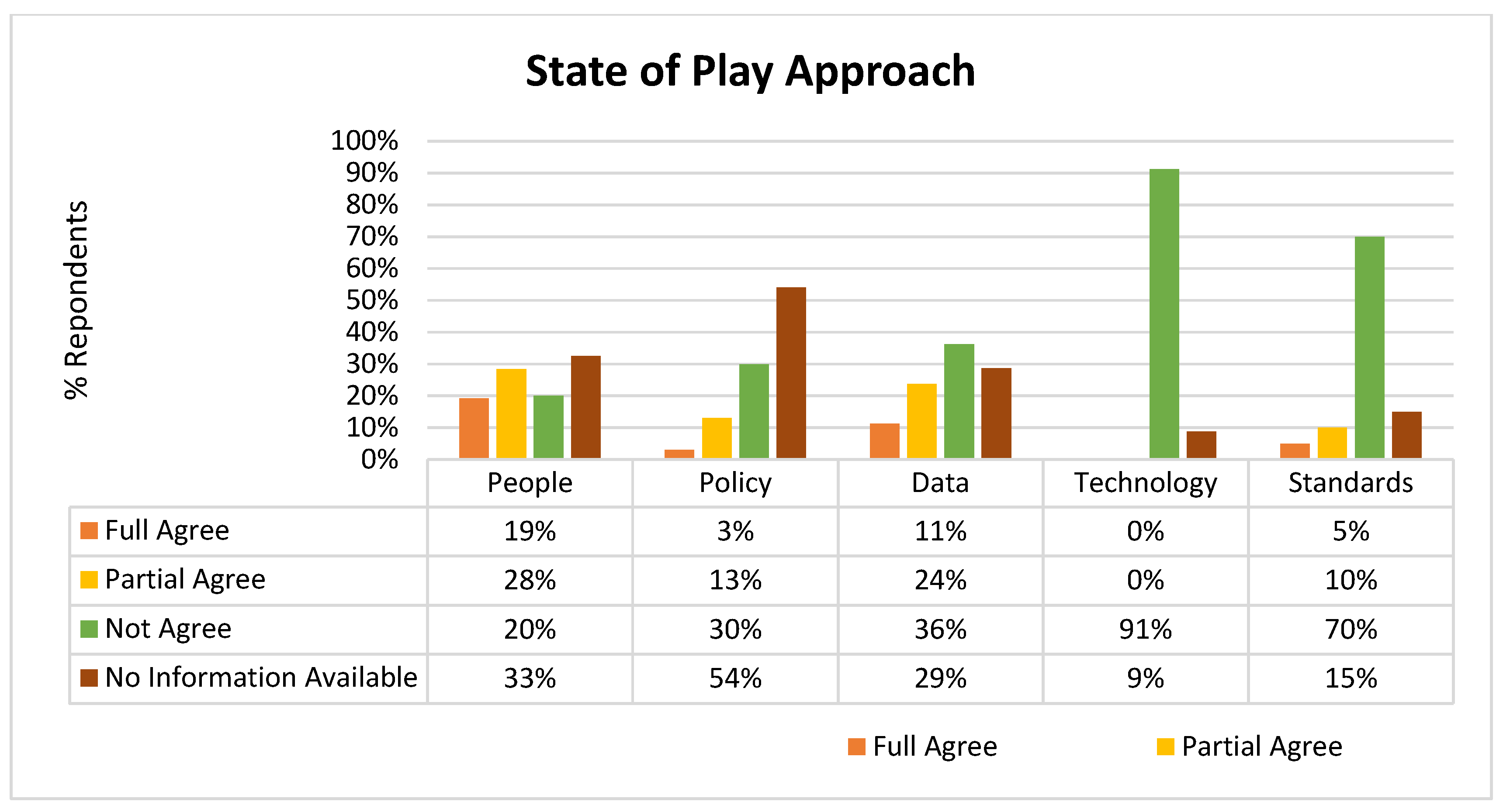

Table 1.
Factors and indicators of the SDI readiness model adapted from [38].
Table 1.
Factors and indicators of the SDI readiness model adapted from [38].
| Factors | Indicators |
|---|---|
| Organizational Infrastructure | A vision of politicians about SDI (Ov) |
| Institutional leadership (Ol) | |
| Legal framework (Of) | |
| Information Infrastructure | Availability of core spatial datasets (Ic) |
| Availability of metadata (Im) | |
| Human Resources | Human capital (Pc) |
| Culture/education regarding SDI (Ps) | |
| Individual leadership (Pl) | |
| Technology Infrastructure | Web connectivity (Aw) |
| Telecommunication infrastructure (At) | |
| Indigenous development of geospatial software (Ad) | |
| Availability of commercial geospatial software (As) | |
| Culture regarding the use of open-source GI software (Ao) | |
| Government-level funding (Fg) | |
| Financial Resources | Mechanism of cost recovery (Fr) |
| Funding from private sector (Fp) |
Table 2.
Weights for the indicators.
| Options | Weights |
|---|---|
| Extremely high | 0.99 |
| Very high | 0.80 |
| High | 0.65 |
| Medium | 0.50 |
| Low | 0.35 |
| Very low | 0.20 |
| Extremely low | 0.01 |
Table 3.
Indicators and sub-indicators adopted from [21].
Table 3.
Indicators and sub-indicators adopted from [21].
| Indicators | Sub-Indicators |
|---|---|
| Leadership | ∙ Does the Government of Pakistan establish Pakistan’s NSDI leadership? ∙ Do need to establish Pakistan’s NSDI is formally supported by the relevant laws or acts or regulations. |
| Inclusiveness & Communication Channels |
∙ Are participants actively participating in the process of establishing SDI at the national or local level? ∙ Does there exist a commitment platform to support and facilitate the journey of establishing Pakistan’s NSDI? |
| Long Term Vision | ∙ Presence of a strategic plan to establish NSDI for is acceptable to all stakeholders? ∙ Are private sector organizations aligned with the development plan of Pakistan’s NSDI? ∙ Most of the organizations are aligned with the strategic plan of Pakistan’s NSDI. |
| Self-Organizing Ability | ∙ SDI community addresses problems in society that may need the availability of relevant geospatial data. Does Pakistan’s NSDI do the same? ∙ Do the level of capacity building and awareness campaigns of Pakistan’s NSDI can influence the societal dynamics? |
| GI Awareness | ∙ Does Pakistan’s NSDI initiative launch an awareness campaign among the citizens to raise the importance of NSDI? ∙ Does Pakistan’s NSDI initiative have an awareness campaign among the private sector and academia? |
| Sustainable Funding | Does Pakistan’s NSDI initiative have sustainable funding? |
Table 4.
Indicators and sub-indicators of the state-of-the-play approach adopted from [21].
Table 4.
Indicators and sub-indicators of the state-of-the-play approach adopted from [21].
| Indicators | Sub-Indicators |
|---|---|
| People | ∙ SDI initiatives being executed in the country are truly national. ∙ One or more components of the SDI architecture have gained a certain level of maturity at the operational level. ∙ The national-level GI association is part of the process of coordination for the establishment of the NSDI initiative. ∙ Only public sector organizations are engaged in the NSDI development. ∙ Enough qualified manpower is available to implement SDI initiatives in the country. ∙ Involvement of spatial data producers & users in the process of the establishment of NSDI. |
| Policy | ∙ True Public-Private Partnerships are available to support and facilitate the initialization, development & commissioning of NSDI-related projects. ∙ There is a "Right of Access to Information Act" which covers legislation about the protection of Geo-Information. ∙ Privacy laws are actively in place by the stakeholders of NSDI. ∙ There is a pricing policy that exists for GI trading. ∙ Existence of relevant framework, guideline, act, law, rules, or policy for spatial data sharing. |
| Data | ∙ All the applicable geodetic reference systems and projection systems are standardized, organized, documented, and interoperable. ∙ Spatial datasets are available for most of the domain areas. ∙ Metadata of reference data & core thematic data is produced at a significant level. ∙ Data quality control procedures and guidelines applicable to NSDI are available in organized and documented form. |
| Technology | ∙ Online access services for metadata are available for one or more organizations. |
| ∙ Online service to download core spatial datasets is available at the national level. | |
| ∙ An online web mapping service is available for the core spatial set at the national level. | |
| ∙ One or more standardized metadata catalogues are available for one or more organizations. | |
| Standards | ∙ All the SDI initiatives paid special attention to issues regarding standards. ∙ The process of data collection is properly standardized for all data collection drives. |
Disclaimer/Publisher’s Note: The statements, opinions and data contained in all publications are solely those of the individual author(s) and contributor(s) and not of MDPI and/or the editor(s). MDPI and/or the editor(s) disclaim responsibility for any injury to people or property resulting from any ideas, methods, instructions or products referred to in the content. |
© 2024 by the authors. Licensee MDPI, Basel, Switzerland. This article is an open access article distributed under the terms and conditions of the Creative Commons Attribution (CC BY) license (https://creativecommons.org/licenses/by/4.0/).
Copyright: This open access article is published under a Creative Commons CC BY 4.0 license, which permit the free download, distribution, and reuse, provided that the author and preprint are cited in any reuse.


