Submitted:
27 June 2024
Posted:
01 July 2024
You are already at the latest version
Abstract
During the 3rd millennium cal BC, the Indus communities exploited great quantities of chert from the Rohri Hills mines in Upper Sindh for making different types of artefacts. This paper discusses the way chert was transported to the Indus Civilization centres and the problems related to the type, quantity and quality of raw material and artefacts that were transported, when, why, and where. This paper raises the question of land and water transport. Both these methods were probably used according to the landscape location of the Indus sites. Another problem regards the landscape characteristics of the Indus Valley during the Bronze Age before the climate changes which took place around the end of the 3rd millennium cal BC, and the disappearance of the Hakra River, which was an important watercourse during the Indus phase. What do we know of the way the Indus communities exploited, transported, and circulated knappable chert? Why the Indus settlements excavated around the Rohri Hills, the largest chert mines of the Indian Subcontinent, have yielded little evidence of chert artefacts and nodules? What do we know of this important problem which is strictly related with the everyday life of the Indus communities and their economy? Why this problem has been systematically neglected by most archaeologists despite its importance?
Keywords:
Greater Indus Valley
; Bronze Age
; Indus Civilization
; Chert mines
; Land and water transport
1. Introduction
This paper discusses some aspects of the Bronze Age Indus Civilization which flourished in the north-western regions of the Indian Subcontinent during the 3rd millennium cal BC [1]. The paper focuses on the Indus chert mines of the Rohri Hills, in Upper Sindh, where the Italian-Pakistani Joint Rohri Hills Project carried out surveys and excavations in the 1990s [2]. The Rohri Hills have yielded the largest chert mining areas of the Indian Subcontinent whose exploitation took place during the Bronze Age. The main scope of this paper is to define the way the chert mined from the hills was transported, how, where, when, and why. To reach the goal, the landscape around the Rohri Hills, the way the Indus and Hakra/Ghaggar (henceforth Hakra) Rivers changed their courses [3,4,5,6,7], and the distribution of the Indus sites so far known in the area will be considered [8].
W.T. Blanford was the first to write a description of the Rohri Hills in 1880. In his seminal volume on the geology of western Sindh he reported the characteristics of the Kirthar limestone which constitutes the hills [9]: 45. “These hills form a rocky area, surrounded by all sides, except the south, by the alluvial plain of the Indus, and slightly broken up at their northern extremity, where they are intersected by the river. To the south the rock is covered up by blown sand, but the latter, farther to the southward, appear to rest on alluvium” [9]: 101. Another point of great interest in Blanford’s description is “an escarpment along the western side of the hills, and the beds dip thence with a steady gentle slope, rarely exceeding 2°, and in many places less than 1°, to the eastward” [9]: 102. The presence of chert artefacts is reported in the following page: “The flints weather out and cover the surface throughout a large area; cores and the flakes split form them being scattered about in abundance in some places” [9[]: 103.
The first knapped stone artefacts were discovered near Sukkur a few years before by Lieutenant-General G. Twemlow “three feet below the rock in the bed of the river (Indus)” [9,10,11]. The hills did not attract the attention of other geologists until 1937, when H. De Terra and T.T. Paterson visited Sukkur. These authors were the first to suggest a chronology for the lithic assemblages discovered near Rohri [12], provide a schematic profile of the hills around Sukkur and Rohri with the location of the knapped stone artefacts in situ, and describe their stratigraphic position on the top of a silt deposit above which “lie migrating dunes” [13]: Figure 193. In their paper they report the presence of “conical cores and very thin long blades reminiscent of the stone industry of Mohenjo Daro” [13]: Plates XLIX and L, which are characteristic Indus Civilization artefacts.
The Indus chert workshops became even more important after the publication of the knapping floors discovered on the terraces that rise south of the city of Rohri by B. Allchin [14]. More recently two chert mines excavated along the western edge of the Shade Shaheed terraces were AMS-dated to the Mature Indus Civilization, more precisely to the middle of the 3rd millennium cal BC (RH-862: 3880±70 BP: GrA-3235; RH-59: 3990±24 BP: GrM-21237) [2,15].
Environmental Setting
The characteristics of the landscape surrounding the Rohri Hills, the presence of two important rivers with very different courses and behaviours, the Indus, in the west, and the Hakra, in the east, and the thick alluvial Indus Plain [16]: 83, will be considered before discussing the way chert artefacts and other lithic material, among which are limestone blocks, were transported to the Bronze Age Indus centres (Figure 1).
Blanford reports the presence of “an escarpment along the western side of the hills” [9]: 102, ca 35-40 m high, east of the shrine of Shadee Shaheed (Figure 2). The most important groups of chert mines were discovered in 1986 on the top of this terrace (ca 135-140 m a.s.l.), which gently slopes towards the east down to the Thar Desert dunes and the Nara Canal which flows partly in an old bed of the Hakra River (ca 65 m a.s.l.).
The satellite and aerial photographs show that the surface of the Rohri Hills is deeply incised by Pleistocene streams which flew down to the Nara Canal and the westernmost Thar Desert fringes [17]. At least seven superimposed seams of good-quality chert are embedded in the almost vertical nummulitic limestone escarpment of the Shadee Shaheed Hills (Figure 3). However, only the uppermost one has been exploited by the Indus miners to extract nodules.
Today the Indus River flows ca 40-50 km west of the westernmost edge of the hills. The alluvial plain consists of deposits at least 6m thick [5]: 295, 8-15m at Mohenjo Daro [18]: 376, which accumulated between the end of the Pleistocene and the recent Holocene [19]: 257. Its surface is incised by ancient river bends the chronology of which has never been defined.
The Indus River changes, inundations [20,21], and the location of freshwater resources in relation to ancient settlements [22]: 50, have been debated for decades with different results [16,22,23,24,25]. The available data show that the territory around the hills was very different from that of the present a few centuries ago [26]: 321, and also during the 3rd millennium cal BC [27,28]. They suggest that the plain has never been an easy landscape to cross because of several natural obstacles: “ease of traversing will depend on topography, on the presence of barriers or impediments, and also on the mode of travel” [29]: 393. We know that when the Mature Indus Civilization flourished the climate was slightly more humid than that of the present, and the changes that led to the present arid conditions began to establish around the end of the same millennium [30,31].
2. Materials and Methods
2.1. The Bronze Age Indus Sites
The distribution of the Indus sites around the Rohri Hills can help us to interpret the way chert was transported, supplied, and where lithic tools were manufactured. Four settlements located within a radius of ca 70 km from the Shadee Shaheed mining area, have been considered for this work. Two are located west of the Indus (Lakheen-Jo-Daro and Mohenjo-Daro), two, east of the river (Kot Diji and Naru Waro Dharo). Unfortunately, our knowledge of the precise quantity and typology of knapped stone artefacts collected from the aforementioned sites is limited by several factors the most important of which are the retrieving techniques employed during excavation. According to the excavation reports, none of the four Indus sites has been water-sieved to fine mesh, with the exception of the bead manufacturing workshop of the Moneer South East Area (MNSE) at Mohenjo-Daro [32].
The Mature Indus city of Lakheen-Jo-Daro is located in the industrial area in the north-western suburbs of Sukkur, close to the right (western) bank of the Indus River (Figure 1, n. 1). Lakheen-Jo-Daro is a large urban settlement whose size has been recently compared to those of the Bronze Age cities of the Greater Indus Valley [33]: 125. The excavations carried out at Lakheen-Jo-Daro yielded many impressive burnt brick structures, among which is a wide road, a small part of which has been excavated [34]. One ordinary radiocarbon date obtained from charcoal shows that at least part of the settlement flourished during the Mature Indus phase, probably around the middle of the 3rd millennium cal BC or slightly later (3960±140 BP: GrN-23123) [28]. According to the excavators, different areas of the site yielded a few knapped stone artefacts made from Rohri chert. They consist of one subconical blade core, unretouched blade and bladelet fragments, a few flakes and crested blades [34].
Mohenjo-Daro is the largest ever excavated and best preserved Bronze Age metropolis of the Greater Indus Valley [35]. Its location and existence, along the right (western) bank of the Indus (Figure 1, n. 2), has been linked with “new means of transport by ship, necessitating settlements close to the river” [36]: 16. Despite its importance, impressive architecture, and the great variety of brick features, among which are hundreds of habitations with superimposed structures [37,38], the chronology of the site is based on only six radiocarbon dates, marking the “poor archaeological control over the remains of the Indus Civilization” in general [35]: 36. They were obtained from burnt wood and charred straw sampled from the excavations carried out by G. Dales [39] at the western edge of the HR mound [40]. The dates fall between 3913±64 BP (P-1179) and 3702±63 BP (P-1182A). The results are generally accepted, while the traditional relative chronology based on sequences of structural units is considered inconsistent [41]: 68, because “no more than an approximate stratigraphical interpretation can be attempted on the results to date” [42]: 163.
A generic description of the Mohenjo-Daro chert artefacts has been provided by J. Marshall [43]: 458. This author illustrated only 12 typical Indus blades, 4 subconical blade cores, and 3 large, retouched chert blocks that he interpreted as agricultural implements [43]: Plate CXXXI: 1-19). G. Dales’s excavations yielded 115 knapped stone artefacts [44]. Thanks to the accurate mapping and water sieving of the deposits [32,45] ca 4000 lithic artefacts, debitage and debris flakelets have been recorded from the bead manufacturing workshops of the “Moneer South East Area (MNSE) of the town, part of a more general surface survey of the craft areas of the ancient urban settlement” [46].
Kot Diji is a mound with a complex sequence located ca 15 km south-west of the shrine of Shadee Shaheed [47]: 43. (Figure 4). The site has been radiocarbon dated between 4421±141 BP (P-196) and 3925±134 BP (P-195) from charcoal samples collected from four different layers [48]. Kot Diji lies very close to the westernmost fringes of the Rohri Hills in an area of ancient river bends (Figure 1, n. 3). The excavations carried out in the 1950s yielded a few knapped stone artefacts among which are cores, blades, sickles and leaf-shaped, bifacial arrowheads [49]: P-62. The lithic assemblages have never been studied in detail. Consequently, it is not possible to distinguish the artefacts of the Early Bronze Age Kot Diji phase from those of the Mature Indus period.
Naru Waro Dharo is a large site that rises from the alluvial Indus Plain ca 8 km north of Kot Diji close to an ancient meander bar of the Indus (Figure. 1, n. 4). The excavations carried out in 1955 did not yield structural remains. Though the site is undated, it has been attributed to the Indus Civilization according to the typological characteristics of the pottery assemblage. The excavator has reported the presence of “chert blades and cores” [50]. The site has been interpreted as a temporary Indus camp due to the absence of structural remains, of a well-defined archaeological horizon, and the presence of ceramic potsherds scattered over a large area [51]: 267.
The distribution of the archaeological sites in this region of Upper Sindh shows that the territory that extends between Shikarpur, in the north, and the Nara Canal, in the east and south, was almost unsettled during the 3rd millennium BC [52]: 179. However, apart from those discussed in this paper, a few more unexcavated and unpublished Indus sites are known in the region [52]: 181-183.
2.2. The Rohri Hills Chert Sources
In December 1975 the Cambridge Archaeological Mission discovered many chert working floors on a few limestone terraces located near Sukkur and Rohri. They were later attributed to the Indus Civilization due to the typological characteristics of the knapped stone artefacts and cores [14,53]. In the spring of 1986, chert mines of the same phase were discovered on the mesas east of the shrine of Shadee Shaheed, in the central-western side of the hills [54]. While the discoveries made by the Cambridge Archaeological Mission consisted of small working floors, those of the 1986 revealed the existence of impressive groups of chert mines characterised by different groups mining pits, heaps of limestone blocks and chert debitage flakes [55,56]. The investigation of the Shadee Shaheed area started a few years later by the Ca’ Foscari University of Venice (I) and Shah Abdul Latif University, Khairpur (PK) “Italian-Pakistani Joint Rohri Hills Project” [57].
The surveys and excavations carried out in the Shadee Shaheed Hills showed the importance of chert in the economy of the Bronze Age Indus Civilization. Before the 1980s, knappable raw materials had been very rarely considered by most archaeologist working in the Greater Indus Valley [58], with very few exceptions [59,60]. The 1993 surveys led to the discovery of thousands of chert mines, workshops [61,62] and other features [57] (Figure 5), very few of which were partly excavated in the following years [2,63,64]. They showed the importance played by knappable stones in a complex Bronze Age urban civilisation and the way chert was extracted from open-air pits to extract good-quality nodules embedded in the uppermost seam of the mesa (Figure 3). Only two Shadee Shaheed mine pits have been radiocarbon dated [15]. The results showed that they were exploited around the middle of the 3rd millennium cal BC, when the Mature Indus Civilization flourished in the region. Unfortunately, radiocarbon dates are not available from the working floors discovered near Rohri and Sukkur by the Cambridge Archaeological Mission in the 1970s due to the absence of organogenic material.
Millions of chert artefacts and impressive heaps of limestone blocks, debitage and waste flakes were visible on the surface of the Shadee Shaheed Hills in the 1990s (Figure 6). The discovery of the Rohri Hills mines has opened many questions regarding the way chert was exploited (Starnini and Biagi, 2006), raw material, finished and unfinished products were transported to the Indus centres, technology and characteristics of the products [65], relationships between producers and consumers [61], the way they were transported, and “what were the most frequent activities in which chipped stone tools were used” [66]: 99. The latter point is very important because we still know very little of it due to the absence of finished tools in the Rohri mining areas and workshops, which is another important argument of discussion [67]. In contrast, specific implements, among which are locally made straight perforators and micro-drills [64] have been recovered from the bead manufacturing areas of Mohenjo-Daro [32], Chanhu Daro [69] in Sindh.
Other urban centres have yielded different types of chert implements among which are notched sickles [70], blades used in agricultural activities [71] and pottery manufacture at Nausharo in Balochistan [72], long end scrapers [46], very few other types of tools [73], and subconical blade cores. Were only finished chert artefacts transported to the Indus centres or both finished and unfinished products and also cores and nodules? What was the market demand like [74], and how it “determined the amount of time and energy expended” in the hills “opposed to other economic and noneconomic activities” [75]: 65? Unfortunately, the only available data come from workshop 480 in the Rohri Hills, from which at least 2000 entire blades were manufactured and exported after removing the percussion bulb [76]. This datum is important to have an idea of the impressive amount of released debitage flakes (Figure 6) and the relationships between production and transportation [77]: 7. Was chert mining a seasonal activity due to the severe, desert summer heat and the monsoon precipitations that followed? We know that today limestone mining takes place during the winter months due to harsh climatic conditions.
2.3. Land and Fluvial Transportation
How was chert transported to the Indus sites located around the hills? Some important characteristics of the central-western side of the Rohri Hills, namely the region close to the shrine of Shadee Shaheed, have been provided by W.T. Blanford [9]: 102. This part of the hills, where the most impressive groups of chert mines are located, has very steep sides, the terrace which is uneasy to reach on foot, is inaccessible by wheeled wagons or carts. We can suggest that other routes were followed to transport lithic material according to “a balance struck between production and transportation costs” [77]: 7.
For sure, the workshops discovered in 1975 by the Cambridge Archaeological Mission in the northernmost part of the hills, where the Indus flows close to the archaeological area, were easier to access. This means that water transport was employed to move chert and limestone blocks to the city of Lakheen-jo-Daro. This is also the case for Mohenjo-Daro, which is located along the right (western) bank of the Indus. In both cases a large river with unique characteristics and dangerous waters in some periods of the year had to be crossed [36,78]. We can assume that flat-bottomed, sliding boats (Figure 7) similar to those of the Indus fishers or Mohanna [79,80] were used to complete such a difficult task also because we know how versatile they are [81,82]. The way the distribution took place and was regulated, is not known. However, a recent analysis of the Indus seals would suggest that these specimens were utilised also to control trade activities which “would have been in the hands of specialist merchants” [83]: 179, although so far we do not have direct evidence of signs related to transport of chert or limestone blocks [84].
The sites of Kot Diji, which is located along the western fringes of the hills, and Naru Waro Dharo, were probably accessed by land. However, the complex landscape of the Indus Plain (Schuldenrein, 2002) and the presence of river bends and forests undoubtedly made its crossing an uneasy task [85,86]. We know that during the Indus phase different types of wheeled transport (carts and chariots) were utilised. This is shown by many complete and fragmented ceramic toys which have been uncovered from the Indus Civilization sites distributed throughout the entire Greater Indus Valley [87].
Following the observations reported above, we can assume that lithic material transportation and distribution towards the Indus centres located around the Rohri Hills was made either by land or water, or both. A more complex system can be suggested for the sites located further away. We do not know the precise radius of distribution of the Rohri chert, although production system is undoubtedly tied to transportation [77]. For sure the distribution of some types reached Harappa in the Punjab and Nausharo in Balochistan [88] in the north, Badin and the Hab River mouth in Lower Sindh [89], and some areas of the Gujarat (India), in the south [90,91]. When did this happen given that the lower Indus Valley is inaccessible for land transportation for some five months a year? [92]: 124.
3. Results
“The identification of the types and sources of the raw materials is not easily achieved and will always leave scope for some ambiguities unless it is backed by precise and extensive scientific evaluations” [93]: 123. This statement is important for the interpretation of mobility and transportation patterns. However, we have to point out that the importance of knappable material, chert in particular, has always been underrated by most archaeologists working in south Asia also in the recent past [57]. This observation is important if we consider the way other materials, pottery in particular, but not only pottery, precious and unique items for example, have always been given a special role not only in constructing cultural and sometimes ephemeral chronological seriations, but also economic strategies and trade patterns. Apart from south Asia, this view has been put forward in other regions of Eurasia especially as regards the Bronze and other metal ages [15]. Reverting to the Indian Subcontinent in general, and Sindh in particular during the Indus phase, attention has sometimes been turned more towards transoceanic and Central Asian contacts than the problem of internal request, movement and production of different types of goods [94].
Some of the problems related with lithic mining, transportation and utilisation of knappable material have been recently re-discussed in the wider context of the importance played by different varieties of knappable raw materials in some countries of Eurasia during the Bronze Age, their exploitation, meaning and social dimension [15]: 422. The research underway in the Greater Indus Valley has changed the obsolete idea of the almost irrelevance of the “lithic factor” during the Bronze Age [95,96]. This fact has been given more relevance thanks to the discovery of the Rohri Hills chert mines, which unfortunately have been almost completely destroyed mainly during the last decade making an irreparable damage to the study of the Indus Civilization and its economic strategy [2,97].
Though we still know almost nothing of road systems in the Indus Valley during the Bronze Age, they have been recovered in other countries where the problem of transportation has been extensively discussed also recently [98].
4. Discussion
The difficulty of defining transport methods and routes followed during the 3rd millennium cal BC Indus communities has already been emphasised by R. Law [88]: 301, who nevertheless remarked the “enormous interaction system – especially in regard to its rock and mineral artefacts”. However, our knowledge is still very scarce at least as regards the movement of chert and limestone blocks all over Sindh. Apart from the exploitation of chert for the activities reported above, we know that this material was utilised also for the manufacture of different types of cubic weights [99]: Plate 113, though so far we do not have evidence of any chert weight workshop either in the Rohri Hills or in the Indus cities of Sindh. As far as we know, squared limestone blocks were employed to cover one of the curved brick drains of the Great Bath in Mohenjo-Daro [41] and to reinforce the basement of brick wall structures (Figure 8). We can suggest that these blocks were mined from the Rohri Hills, which are located less than 50 km east of the city, as the crow flies.
Our knowledge regarding other regions of Pakistan, the Punjab for example, is even scarcer. We know that the Cholistan Desert around Derawar is very rich in Bronze Age sites [100,101], some of which are urban centres of an impressive dimension, Ganweriwala for example (Figure 9) [102], that were built along the banks of the Hakra River which changed its course around the end of the Bronze Age [3]. We can suggest that also the Hakra River was exploited for transporting lithic material from the Rohri Hills to the cities of the northern regions. In this respect, it is important to point out once more that the Rohri Hills terraces are inclined to the east, towards the ancient course of the Hakra River which, in Indus times, lapped the eastern side of the hills.
If our knowledge of the way chert was supplied to the Bronze Age cities of this part of Upper Sindh is still insufficient, we have to admit that we know even less of other regions of the Greater Indus Valley. In her paper on the transportation systems employed during the Indus phase and historical periods, Miller [103] discussed several aspects of land and water transport. Very recently, scientific analyses have shown some evidence of land, bovid-driven, short and also long-distance transport [104]. However, to improve our knowledge the number of isotopic analyses would need to be multiplied.
5. Conclusions
The problems of resources, technology, trade and transportation have been largely debated by the specialists of the Bronze Age of Europe [105]. The same can be said of the presence of wheeled chariots and carts during the 3rd millennium cal BC, and the complex structure of some of these vehicles already when they made their appearance in several countries of Eurasia around the beginning of the metal ages [106,107], roughly same period when they started to be utilised in the Indian Subcontinent [87]: 6.
V.G. Childe was the first to distinguish between two and four-wheeled wagons, to discuss where and when they were in use. Regarding the Indus Civilization, he was also the first to suggest that carts and wagons were utilised “from a considerable distance over land on which carts would easily travel” [108]: 178, “played the same role in provisioning the great Harappan cities” [108]: 183, “transport was facilitated by wheeled vehicles and boats” [109]: 176, and “in Egypt, where all cultivable land lies close to the Nile, boats took the place of carts” [108]: 177. All these observations, which were written more than seventy years ago, are still actual today, and are part of the debate on the transport of materials within the Greater Indus Valley.
The transportation problems put forward by the aforementioned authors are basically the same that we are facing today, despite our knowledge has improved especially with regard to the characteristics of the territory where the Indus Civilization flourished, the chronology of the most important events, raw materials exploitation and trade, and mining activities.
Though the present paper has been centred mainly on an underrated problem, chert and its transportation, the general impression is that it can be extended to other aspects of great economic or subsistence importance whose study has not improved during the last decades, plant use and agriculture for example [110,111] because “surges in agricultural productivity follow the growth of cities” [112]: 7.
Acknowledgments
The Author is very grateful to all the members of the Italian-Pakistani “Joint Rohri Hills Project” who took part in the research. Special thanks are due to the Italian Ministry of Foreign Affairs and International Cooperation (MAECI) that sponsored and financed the Mission.
References
- Shaffer, J. The Indus Valley, Baluchistan, and Helmand traditions: Neolithic through Bronze Age. In Chronologies in old world archaeology, Ehrich, R.W. Ed.; University of Chicago Press, Chicago, 1992, pp. 441–464.
- Biagi, P.; Starnini, E.; Michniak, R. Chert mines and chert miners: Material culture and social organization of the Indus Civilization chipped stone workers, artisans and traders in the Indus Valley (Sindh, Pakistan). In Walking with the Unicorn – Jonathan Mark Kenoyer Felicitation Volume; Frenez, D.; Jamison, G.; Law, R.; Vidale, M.; Meadow, R. Eds; Archaeopress, Oxford, 2018, pp. 63–84.
- Wilhelmy, H. The ancient river valley on the eastern border of the Indus Plain and the Saraswati problem. Zeitschrift für Geomorphologie, Supplementary Band 8, 1969, 76–93.
- Flam, L. Fluvial Geomorphology of the Lower Indus Basin (Sindh, Pakistan) and the Indus Civilization. In Himalaya to the Sea. Geology, geomorphology and the Quaternary, Shroder, J.F. jr. Ed.; Routledge, London and New York, 1993, pp. 265–287.
- Jorgensen, D.W.; Harvey, M.D.; Schumm, S.A.; Flam, L. Morphology and Dynamics of the Indus River: Implications for the Mohenjo Daro Site. In Himalaya to the Sea. Geology, geomorphology and Quaternary, Shroder, J.F. jr. Ed.; Routledge, London and New York, 1993, pp. 288–326.
- Petrie, C.A.; Singh, R.N.; Bates, J.; Dixit, Y.; French, C.A.I.; Hodell, D.A.; Jones, P.J.; Lancelotti, C.; Lynam, F.; Neogi, S.; et al. Adaptation to Variable Environments, Resilience to Climate Change: InvestigatingLand, Water and Settlementin Indus Northwest India. Curr. Anthr. 2017, 58, 1–30. [Google Scholar] [CrossRef]
- Singh, A.; Thomsen, K.J.; Sinha, R.; Buylaert, J.-P.; Carter, A.; Mark, D.F.; Mason, P.J.; Densmore, A.L.; Murray, A.S.; Jain, M.; et al. Counter-intuitive influence of Himalayan river morphodynamics on Indus Civilisation urban settlements. Nat. Commun. 2017, 8, 1–14. [Google Scholar] [CrossRef] [PubMed]
- Flam, L. The Prehistoric Indus River System and the Indus Civilization in Sindh. Man and Environment, 1999a, XXIV (2), 35–69.
- Blanford, W.T. The Geology of Western Sind. Memoirs of the Geological Survey of India, 1880, 17, 1–210. [Google Scholar]
- Evans, J. I. —On some Flint-cores from the Indus, Upper Scinde. Geol. Mag. 1866, 3, 433–435. [Google Scholar] [CrossRef]
- Majumdar, N.C. Explorations in Sind. Being a report of the exploratory survey carried out during the years 1927-28, 1929-30 and 1930-31. Memoirs of the Archaeological Survey of India, 48. Delhi. Indus Publications, Karachi, 1934 (1981 reprint).
- Paterson, T.T. The Industries of Sukkur and Rohri. In The Ice Age in the Indian Subcontinent and Associated Human Cultures with special Reference to Jammu, Kashmir, Ladakh, Sind, Liddar and Central & Peninsular India, De Terra, H.; Paterson, T.T. Eds; Carnegie Institute, Washington DC, 1939, pp. 333–336.
- De Terra, H.; Paterson, T.T. The Late Stone Age Sites at Sukkur and Rohri, on the Lower Indus in Upper Sind. In The Ice Age in the Indian Subcontinent and Associated Human Cultures with special Reference to Jammu, Kashmir, Ladakh, Sind, Liddar and Central & Peninsular India, De Terra, H., Paterson, T.T. Eds; Carnegie Institute, Washington DC, 1939, pp. 331–333.
- Allchin, B. Palaeolithic Sites in the Plains of Sind and Their Geographical Implications. Geogr. J. 1976, 142, 471. [Google Scholar] [CrossRef]
- Biagi, P.; Nisbet, R. Mining Bronze Age Stone Resources: Some examples from the Caucasus (Georgia) and Sindh (Pakistan). In Aere Perennius. More Lasting than Bronze. Essays in honour of Valentin Dergachev on the occasion of his 80th birthday; Dergacheva, L. Ed.; Stratum Library, Kishinev, 2023, pp. 413–431.
- Pithawalla, M. A Physical and Economic Geography of Sind. Sindhi Adabi Board, Hyderabad and Karachi, 1959.
- Usman, M.; Clift, P.D.; Pastore, G.; Vezzoli, G.; Andò, S.; Barbarano, M.; Vermeesch, P.; Garzanti, E. Climatic influence on sediment distribution and transport in the Thar Desert (Sindh and Cholistan, Pakistan). Earth-Science Rev. 2024, 249. [Google Scholar] [CrossRef]
- Jansen, M.R.N. Mohenjo Daro and the River Indus. In The Indus River: Biodiversity, Resources, Humankind, Meadow, A.; Meadow, P. Eds;. Oxford University Press, Karachi, 1999, pp. 349–383.
- Beg, M.A.A. . Surface Soils and Indus River Sediments. In Himalaya to the Sea. Geology, geomorphology and the Quaternary: Shroder, J.F. jr. Ed;. Routledge, London and New York; 1993, pp. 251–264.
- Carless, T.G. Report upon Portions of the River Indus; Surveyed in the Years 1836-37 Accompanied by a Journal kept by that Officer during that Period. In Hughes, T.R. Ed.; Memoirs on Sind. Selections from the Records of the Bombay Government, 1855, XVII, 500–588 (1989 reprint).
- Weil, B. The Rivers Come: Colonial Flood Control and Knowledge Systems in the Indus Basin, 1840s-1930s. Environ. Hist. 2006, 12, 3–29. [Google Scholar] [CrossRef]
- Panhwar, M.N. Ground Water in Hyderabad and Khairpur Divisions. G. Shariff at Capital Press, Hyderabad, 1964.
- Pithawalla, M. Settlements in the Lower Indus Basin (Sind). Journal of the Madras Geographical Association, 1938, XIII (4), 323–357.
- Wilhelmy, H. Der `wandernde´ Strom. Studien zur Talgeschichte des Indus. Erdkunde 1966, 20. [Google Scholar] [CrossRef]
- Flam, L. Ecology and Population Mobility in the Prehistoric Settlement of the Lower Indus Valley, Sindh, Pakistan. In The Indus River: Biodiversity, Resources, Humankind, Meadow, A.; Meadow, P. Eds; Oxford University Press, Karachi, 1999b, pp. 313–323.
- Raverty, H.G. The Mihrán of Sind and its tributaries. Baptist Mission Press, Calcutta, 1895 (1979 Reprint).
- Flam, L. Recent Explorations in Sind: Paleogeography, Regional Ecology, and Prehistoric Settlement Patterns (ca. 4000-2000 B.C.). In Studies in the Archaeology of India and Pakistan, Jacobson, J. Ed.; Aris & Phillips, Warminster, 1987, pp. 65–90.
- Biagi, P.; Vidale, M. Lakheen-Jo-Daro, an Indus Civilization Settlement at Sukkur in Upper Sindh (Pakistan): A Scrap Copper Hoard and Human Figurine from a Dated Context. Asian Perspect. 2022, 61, 2–27. [Google Scholar] [CrossRef]
- Wilson, L. Understanding Prehistoric Lithic Raw Material Selection: Application of a Gravity Model. J. Archaeol. Method Theory 2007, 14, 388–411. [Google Scholar] [CrossRef]
- Staubwasser, M.; Sirocko, F.; Grootes, P.M.; Segl, M. Climate change at the 4.2 ka BP termination of the Indus valley civilization and Holocene south Asian monsoon variability. Geophys. Res. Lett. 2003, 30. [Google Scholar] [CrossRef]
- Wright, R.P.; Bryson, R.A.; Schuldenrein, J. Water supply and history: Harappa and the Beas regional survey. Antiquity 2008, 82, 37–48. [Google Scholar] [CrossRef]
- Vidale, M. Some Aspects of Lapidary Craft at Moenjodaro in the Light of the Surface Record of the Moneer South East Area. In Reports on Field Work Carried out at Mohenjo-Daro Pakistan 1983-84, Jansen, M.; Urban, G. Eds; IsMEO-Aachen University Mission. Interim Reports, 1987, 2, 113–149 Aachen, Rome. [Google Scholar]
- Prabhakar, V.N. Symbols of Elite and Interregional Ideological Transmissions During Harappan Phase as Gleaned from Dholavira. In Research on Indus Civilization in the Wake of Hundred Years of Excavation at Harappa, Rajesh, S.V.; Abhayan, G.S.; Nayar, P. Eds; Department of Archaeology, University of Kerala, 2023, pp. 123–159.
- Shaikh, N.; Veesar, G.M.; Mallah, Q.H. Excavations of Indus period site Lakhan-Jo-Daro 2006. Ancient Sindh, 2004- 2005, 8, 7–196. [Google Scholar]
- Possehl, G.L. The Indus Civilization. A Contemporary Perspective. Vistaar Publications, New Delhi, 2002.
- Jansen, M. . Preliminary Results of the “forma Urbis” Research at Mohenjo-Daro. In Reports on Field Work Carried out at Mohenjo-Daro Pakistan 1983-84, Jansen, M.; Urban, G. Eds; IsMEO-Aachen University Mission. Interim Reports, 1987b, 2, 9–22. Aachen, Rome.
- Jansen, M. Theoretical Aspects of Structural Analyses for Mohenjo-Daro. In Reports on Field Work Carried out at Mohenjo-Daro Pakistan 1983-84, Jansen, M.; Urban, G. Eds; IsMEO-Aachen University Mission. Interim Reports, 1987a, 1, 39–62. Aachen, Rome.
- Eltsov, P. Power circumscribed by space: Attempting a new model of the ancient South Asian city. In Current Studies on the Indus Civilization, Osada, T.; Uesugi, A. Eds; 2016, VI, 35–72.
- Dales, G.F. New excavations at Mohenjo-daro. Archaeology, 1965, 18, 145–150. [Google Scholar]
- Stuckenrath, R. University of Pennsylvania Radiocarbon Dates X. Radiocarbon 1967, 9, 333–345. [Google Scholar] [CrossRef]
- Jansen, M. Mohenjo-Daro, Indus Valley Civilization: Water Supply and Water Use in One of the Largest Bronze Age Cities of the Third Millennium bc. In A History of Water: Series III, Volume 1. Water and Urbanization, Tvedt, T.; Oestigaard, T. Eds; Bloombsbury, London, 2014, pp. 52–70. [CrossRef]
- Jansen, M. Mohenjo-Daro – a City on the Indus. In Forgotten Cities on the Indus. Early Civilization in Pakistan from the 8th to the 2nd Millennium BC. Jansen, M.; Mulloy, M.; Urban, G. Eds; Phillip von Zabern, Mainz, 1991, pp. 145–166.
- Marshall, J. Mohenjo-Daro and the Indus Civilization. Being an official account of archaeological excavations at Mohenjo-Daro carried outy by the Government of India between the years 1922 and 1927. Arthur Probsthain, London, 1931 (3 volumes).
- Kenoyer, J.M. Chipped Stone Tools from Mohenjodaro. In Frontiers of the Indus Civilization, Lal, B.B.; Gupta, S.P. Eds, Ed.; New Delhi: Books and Books, 1984; pp. 117–132. [Google Scholar]
- Tosi, M.; Bondioli, L.; Vidale, M. Craft Activity Areas and Surface Survey at Moenjodaro. Complementary Procedures for the Revalutation of a Restricted Site. In Reports on Field Work Carried out at Mohenjo-Daro Pakistan 1983-84, Jansen, M.; Urban, G. Eds; IsMEO-Aachen University Mission. Interim Reports, 1987, 1, 9–Aachen, Rome. [Google Scholar]
- Vidale, M.; Siviero, A.; Sidoti, G.; Guida, G.; Priori, G. Three end-scrapers from Mohenjo-Daro (Pakistan). In Unconformist Archaeology: Papers in honour of Paolo Biagi, Starnini, E. Ed.;. BAR International Series, 2528, 2013, 119–129 Archaeopress, Oxford. [Google Scholar]
- Khan, F.A. Excavations at Kot Diji. Pakistan Archaeology, 1964a, 1, 39–43.
- Ralph, E.K. University of Pennsylvania Radiocarbon Dates III. Radiocarbon 1959, 1, 45–58. [Google Scholar] [CrossRef]
- Khan, F.A. The Glory that was Kot Diji Culture of Pakistan. An Archaeology Outline. Shah Abdul Latif University, Khairpur, 2002.
- Khan, F.A. Excavations at Naru Waro Dharo. Pakistan Archaeology, 1964b, 1, 43–44.
- Hegde, K.T.M.; Fairservis, W.A. The Roots of Ancient India: The Archaeology of Early Indian Civilization. Man 1973, 8, 644. [Google Scholar] [CrossRef]
- Cousens, H. The Antiquities of Sind. Calcutta. Department of Culture, Government of Sindh, Karachi, 1929 (1998 reprint).
- Allchin, B. Some Questions of Environment and Prehistory in the Indus Valley from Palaeolithic to Urban Indus Times. In The Indus River: Biodiversity, Resources, Humankind; Meadow, A., Meadow, P., Eds; Oxford University Press, Karachi, 1999; pp. 284–299.
- Biagi, P.; Cremaschi, M. The Harappan flint quarries of the Rohri Hills (Sind-Pakistan). Antiquity 1991, 65, 97–102. [Google Scholar] [CrossRef]
- Biagi, P.; Ottomano, C.; Pessina, A.; Shaikh, N. The 1994 Campaign on the Rohri Hills (Sindh-Pakistan): A Preliminary Report. Ancient Sindh, 1995, 2, 13–40. [Google Scholar]
- Starnini, E.; Biagi, P. Excavations at the Harappan Flint Quarry 862 on the Rohri Hills (Sindh, Pakistan). In Stone Age – Mining Age, Körlin, G.; Weisgerber, G. Eds; Der Anschnitt, 2006, 19, 195–202. [Google Scholar]
- Biagi, P. , Pessina, A. Surveys and Excavations in the Rohri Hills (Sindh-Pakistan): A Preliminary Report of the 1993 Campaign. Ancient Sindh, 1994, 1, 13–76. [Google Scholar]
- Lahiri, N. The Archaeology of Indian Trade Routes (upto c. 200 BC). Resource Use, Resource Access and Lines of Communication. Oxford University Press, Delhi, 1992.
- Hoffman, M.A.; Cleland, J.H. Excavations at the Harappan Site of Allahdino. The Lithic Industry at Allahdino. A Metric and Quantitative Analysis of an Harappan Activity System. Papers of the Allahdino Expedition, 1977, 2, 1–150 New York. [Google Scholar]
- Cleland, J.H. Lithic Analysis and Cultural Process in the Indus Region. In Studies in the Archaeology of India and Pakistan; Jacobson, J. Ed.; Aris & Phillips, Warminster, 1987, pp. 91–116.
- Costin, C.L. Craft Production. In Handbook of Methods in Archaeology; Maschner, H. Ed.: AltaMira Press, Lanham, 2005, pp. 1032–1105. [Google Scholar]
- Costin, C.L. What is a Workshop? In Approaches to the Analysis of Production Activity at Archaeological Sites, Hodgkinson, A.K.; Tvetmarken, C.L. Eds; Archaeopress Archaeology, Oxford, 2020, pp. 177–197.
- Negrino, F.; Ottomano, C.; Starnini, E.; Veesar, G.M. Excavations at Site 862 (Rohri Hills, Sindh, Pakistan): A Preliminary Report of the 1995 and 1997 Campaigns. Ancient Sindh, 1996, 3, 67–104. [Google Scholar]
- Starnini, E.; Biagi, P. The Archaeological Record of the Indus (Harappan) Lithic Production: The Excavation of RH862 Flint Mine and Flint Working Workshops on the Rohri Hills (Upper Sindh, Pakistan). Journal of Asian Civilizations, 2011, 34 (2), 1–62.
- Briois, F.; Negrino, F.; Pelegrin, J.; Starnini, E. Flint exploittaion and blade production during the Harappan period (Bronze Age): testing the evidence from the Rohri Hills flint mines (Sindh. Pakistan) throughout an experimental approach. In Körlin, G.; Weisgerber, G. Eds; Stone Age – Mining Age. Der Anschnitt, 2006, 19, 307–313. [Google Scholar]
- Schiffer, M.B. Behavioral Archaeology. Academic Press, New York, 1976.
- Saville, A. Prehistoric Quarrying of a Secondary Flint Source: Evidence from North-East Scotland. In The Cultural Landscapes of Prehistoric Mines, Topping, P.; Lynott, M. Eds; Oxbow Books, Oxford, 2005, pp. 1–13.
- Tosi, M.; Piperno, M. Lithic technology behind the ancient lapis lazuli trade. Expedition, 1973, 16 (1), 15–23.
- Didier, A. Nouvelles recherches sur les débuts de la civilisation de l’Indus au Pakistan. Les fouilles de Chanhu-Daro (Sindh). 2017, 161, 969–1002. [Google Scholar] [CrossRef]
- Voytek, B.A. Notes on a Flint Sickle from Kot Diji. Ancient Sindh, 1994, 1, 77–79. [Google Scholar]
- Gadekar, C.; García-Granero, J.J.; Madella, M.; Lancelotti, C.; Veesar, G.M.; Alam Abro, T.; Chandio, M.A.; Zurro, D. Phytoliths and lithics: An alliance of convenience? Performing first comprehensive residue analysis for the artefacts of the Indus Civilisation. J. Archaeol. Sci. Rep. 2023, 52. [Google Scholar] [CrossRef]
- Méry, S.; Anderson, P.; Inizan, M.-L.; Lechevallier, M.; Pelegrin, J. A pottery workshop with flint tools on blades knapped with copper at Nausharo (Indus civilisation, ca. 2500 BC). J. Archaeol. Sci. 2007, 34, 1098–1116. [Google Scholar] [CrossRef]
- Davis, M. Stone tools as Indicators of Socio-Economic Variability at Harappa, Pakistan. In Contextualizing Material Culture in South and Central Asia in Pre-Modern Times. Papers from the 20th Conference of the European Association for South Asian Archaeology and Art held in Vienna from 4th to 9th 10. Widorn, V.; Franke, U.; Latschenberger, P. Eds; Brepols, Turnhout, 2016, pp. 51–65. 20 July.
- Neale, W.C. The Market in Theory and History. In Trade and Market in the Early Empires. Economies in History and Theory, Polanyi, K.; Arensberg, C.M.; Pearson, H.W. Eds; The Free Press, Glencoe, Illinois, 1957, pp. 357–372.
- Luedtke, B.E. Lithic material demand and quarry production. In Prehistoric Quarries and Lithic Production; Ericson, J.E., Purdy, B.A. Eds, Eds.; Cambridge University Press: Cambridge, UK, 1984; pp. 65–76. [Google Scholar]
- Negrino, F. , Starnini, E. A Preliminary Report of the 1994 Excavations on the Rohri Hills (Sindh – Pakistan). Ancient Sindh, 1995, 2, 55–80. [Google Scholar]
- Ericson, J.E. Toward the analysis of lithic production systems. In Prehistoric Quarries and Lithic Production, Ericson, J.E.; Purdy, B.A. Eds; Cambridge University Press, Cambridge, 1984, pp. 1–9.
- Giosan, L.; Constantinescu, S.; Clift, P.D.; Tabrez, A.R.; Danish, M.; Inam, A. Recent morphodynamics of the Indus delta shore and shelf. Cont. Shelf Res. 2006, 26, 1668–1684. [Google Scholar] [CrossRef]
- Shar, G.M. The Mohanna – An Unknown Life in the Indus River. In Reports on Field Work Carried out at Mohenjo-Daro Pakistan 1983-84, Jansen, M.; Urban, G. Eds; IsMEO-Aachen University Mission. Interim Reports, 1987, 2, 169–181 Aachen, Rome. [Google Scholar]
- Baloch, N.A. In Search of the Indus Culture Sites in Sind. Bulletin of the Institute of Sindhology, 1973, III (2 and 3), 11–32.
- Casson, L.; Greenhill, B. Archaeology of the Boat: A New Introductory Study. Am. Hist. Rev. 1977, 82, 606. [Google Scholar] [CrossRef]
- Greenhill, B. Boats and Boatmen of Pakistan. David & Charles, Newton Abbot, 1971.
- Allchin, R.; Allchin, B. Origins of a Civilization. The Prehistory and Early History of South Asia. Viking, New Delhi, 1997.
- Mukhopadhyay, B.A. Semantic scope of Indus inscriptions comprising taxation, trade and craft licensing, commodity control and access control: archaeological and script-internal evidence. Humanit. Soc. Sci. Commun. 2023, 10, 1–38. [Google Scholar] [CrossRef]
- Raikes, R. Water, Weather and Prehistory. John Baker, London. 1967.
- Mears, P.; Wilson, L. A game of two halves: Looking for evidence for both embedded and direct procurement in a simulated dataset. J. Lithic Stud. 2023, 10, 19. [Google Scholar] [CrossRef]
- Kenoyer, J.M. Carts and wheeled vehicles of the Indus Civilization: New evidence from Harappa, Pakistan. In Current Studies on the Indus Civilization, Osada, T.; Uesugi, A. Eds; 2011, VI, 1–34.
- Law, R. Moving Mountains: The Trade and Transport of Rocks and Minerals Within the Greater Indus Valley Region. In Space and Spatial Analysis in Archaeology, Robertson, E.C.; Seibert, J.D.; Fernandez, D.C.; Zender, M.U. Eds; University of Calgary Press, Alberta, 2006, pp. 301–313.
- Biagi, P. New Radiocarbon Dates for the Prehistory of the Arabian Sea Coast of Lower Sindh and Las Bela in Balochistan (Pakistan). Rivista di Archeologia, 2004. XXVIII, 5–16.
- Gadekar, C.; Rajesh, S.V.; Ajithprasad, P. Shikarpur lithic assemblage: New questions regarding Rohri chert blade production. J. Lithic Stud. 2014, 1, 137–149. [Google Scholar] [CrossRef]
- Banerjee, R.; Prabhakar, V.N.; Bisht, R.S. Harappa Blade Implements: A Literature Review and Future Perspectives. Heritage: Journal of Multidisciplinary Studies in Archaeology, 2018, 6, 276–298. [Google Scholar]
- Jansen, M. Settlement Networks of the Indus Civilization. In Indian Archaeology in Retrospect. Protohistory. Archaeology of the Harappan Civilization. Volume II. Settar, S.; Korisettar, R. Eds; Indian Council of Historical Research, Lordson, Delhi, 2002, pp. 105–128.
- Chakrabarti, D.K. The External Trade of the Indus Civilization. Munshiran Manoharlal, New Delhi, 1990.
- Chakrabarti, D.K. Theoretical Issues in Indian Archaeology. Munshiran Manoharlal, New Delhi, 1988.
- Betts, A.V.G.; Rosen, S.A. Lithics after the Stone Age: A Handbook of Stone Tools from the Levant. Am. J. Archaeol. Hist. Fine Arts 1998, 102, 644. [Google Scholar] [CrossRef]
- Müller-Neuhof, B. Southwest Asian Late Chalcolithic/Early Bronze Age Demand for “Big-Tools”: Specialized Flint Exploitation Beyond the Fringes of Settled Regions. Lithic Technol. 2013, 38, 220–236. [Google Scholar] [CrossRef]
- Biagi, P. Quarries in Harappa. In Encyclopaedia of the History of Science, Technology, and Medicine in Non-Western Cultures; Selin, H., Ed.; Springer Science+Business Media Dordrecht, 2014, pp. 1–17. [CrossRef]
- Nessel, B.; Hunér, C. Transportation in Bronze Age Europe. In Digging in the Past of Old Europe: Studies in Honor of Cristian Schuster at his 60th Anniversary, Sîrbu, V.; Comşa, A.; Hortopan, D. Eds;. Editura Istros a Muzeului Brăilei Carol I, Brăila, 2019, pp. 255–275.
- Dales, G.F. The Phenomenon of the Indus Civilization. In Forgotten Cities on the Indus. Early Civilization in Pakistan from the 8th to the 2nd Millennium BC.; Jansen, M.; Mulloy, M.; Urban, G. Eds; Phillip von Zabern, Mainz, 1991, pp. 129–144.
- Stein, A. Survey of Old Sites Along the Hakra Bed in Bahawalpur. In The ‘Lost’ Sarasvati and the Indus Civilization, Gupta, S.P. Ed.; Kusumanjali Prakashan, Jodhpur, 1995, pp. 57–97.
- Mughal, M.R. Ancient Cholistan. Archaeology and Architecture. Ferozsons (Pvt.) Ltd., Lahore, 1997.
- Masih, F.; Tofique, A. Harapppan Site of Sidduwala in Cholistan: An Introduction. Heritage: Journal of Multidisciplinary Studies in Archaeology, 2014, 2, 844–853. [Google Scholar]
- Miller, H.M.-L. Comparing Landscapes of Transportation: Riverine-Oriented and Land-Oriented Systems in the Indus Civilization and the Mughal Empire. In Space and Spatial Analysis in Archaeology, Robertson, E.C.; Seibert, J.D.; Fernandez, D.C.; Zender, M.U. Eds; University of Calgary Press and University of New Mexico Press, 2006, pp. 281–292.
- Petrie, C.A.; Lightfoot, E.; Jones, P.J.; Walker, J.R.; Valentine, B.T.; Krigbaum, J.; le Roux, P.; Joglekar, P.P.; Shinde, V.; Singh, R.N.; et al. Animal movement on the hoof and on the cart and its implications for understanding exchange within the Indus Civilisation. Sci. Rep. 2024, 14, 1–14. [Google Scholar] [CrossRef]
- Sherratt, A. Resources, Technology and Trade: An Essay on Early European Metallurgy. In Problems in Social and Economic Archaeology, Longworth, I.; Sieveking, G. de G.; Wilson, K. Eds; Duckworth, London, 1976, pp. 557–581. [CrossRef]
- Piggott, S. The Earliest Wheeled Vehicles and the Caucasian Evidence. Proc. Prehist. Soc. 1969, 34, 266–318. [Google Scholar] [CrossRef]
- Sherratt, A. The secondary exploitation of animals in the Old World. World Archaeol. 1983, 15, 90–104. [Google Scholar] [CrossRef]
- Childe, V.G. The First Waggons and Carts—from the Tigris to the Severn. Proc. Prehist. Soc. 1951, 17, 177–194. [Google Scholar] [CrossRef]
- Childe, V.G. New Light on the Most Ancient East. Grove Press, New York, 1957.
- Weber, S.A. Plants and Harappan Subsistence. Oxford & IBH, New Delhi, 1991.
- Fuller, D.; Madella, M. Issues in Harappan Archaeobotany: Retrospect and Prospect. In Indian Archaeology in Retrospect. Protohistory. Archaeology of the Harappan Civilization. Volume II. Settar, S.; Korisettar, R. Eds; Indian Council of Historical Research, Lordson, Delhi, 2002. pp. 316–390.
- Jacobs, J. The Economy of Cities. Vintage Books, New York, 1968.
- Possehl, G.L. A Short History of Archaeological Discovery at Harappa. In Harappa Excavations 1989-1990. A Multidisciplinary Approach to Third Millennium Urbanism. Meadow, R.H. Ed.; Monographs in World Archaeology, 1991, 3, 5–11 Prehistory Press, Madison. [Google Scholar]
- Lahiri, N. Finding Forgotten Cities. How the Indus Civilization was Discovered. Permanent Black, New Delhi, 2005.
- Mukhopadhyay, B.A. Semantic scope of Indus inscriptions comprising taxation, trade and craft licensing, commodity control and access control: archaeological and script-internal evidence. Humanit. Soc. Sci. Commun. 2023, 10, 1–38. [Google Scholar] [CrossRef]
Figure 1.
Distribution of the Upper Sindh Indus sites discussed in the text: Lakheen-jo-Daro (1), Mohenjo-Daro (2), Kot Diji (3), Naru Waro Daro (4) (Drawing by P. Biagi).
Figure 1.
Distribution of the Upper Sindh Indus sites discussed in the text: Lakheen-jo-Daro (1), Mohenjo-Daro (2), Kot Diji (3), Naru Waro Daro (4) (Drawing by P. Biagi).
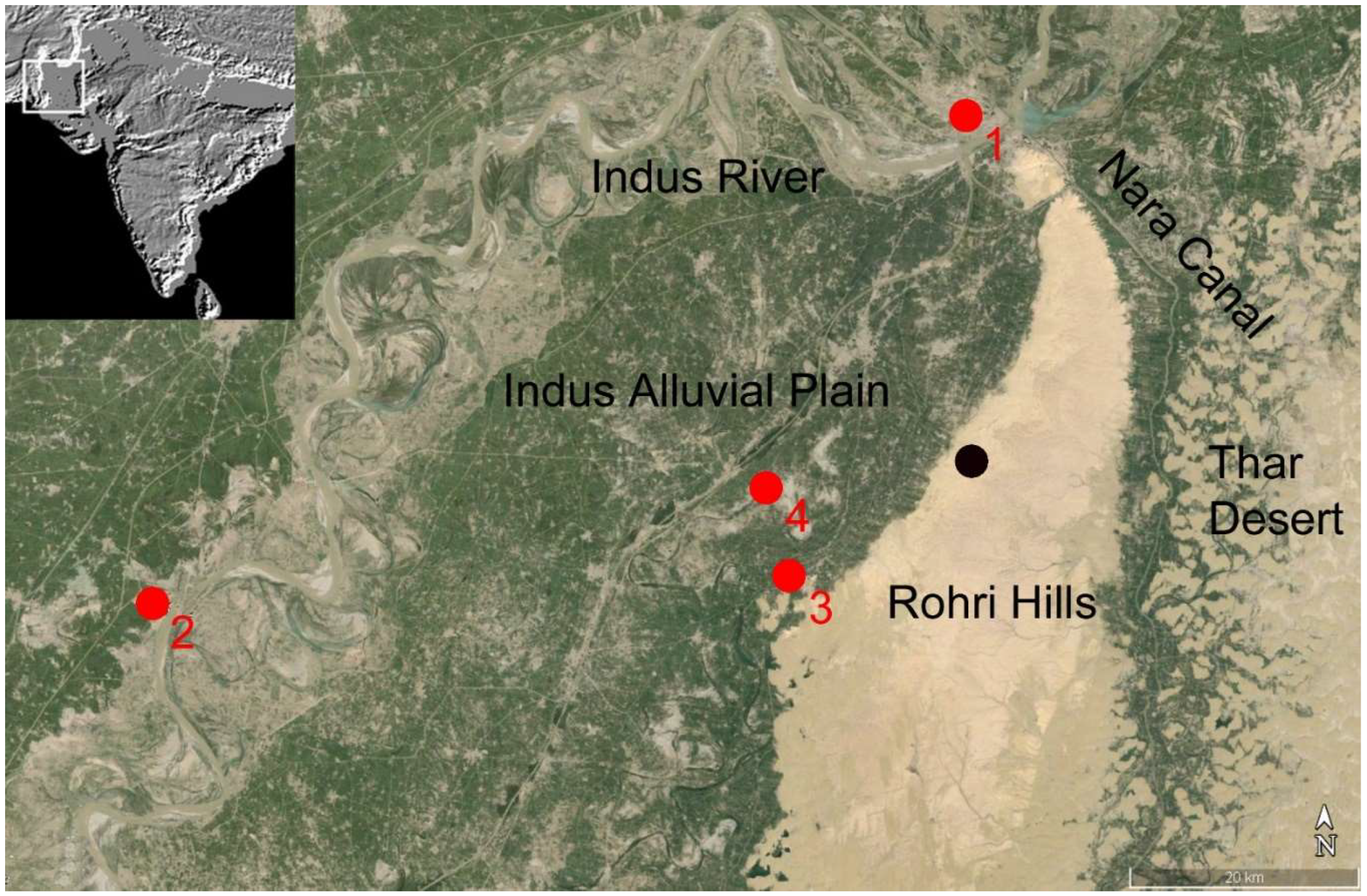
Figure 2.
Rohri Hills: The steep, western fringes of the hills east of the Shrine of Shadee Shaheed (Photograph by P. Biagi, 1986).
Figure 2.
Rohri Hills: The steep, western fringes of the hills east of the Shrine of Shadee Shaheed (Photograph by P. Biagi, 1986).
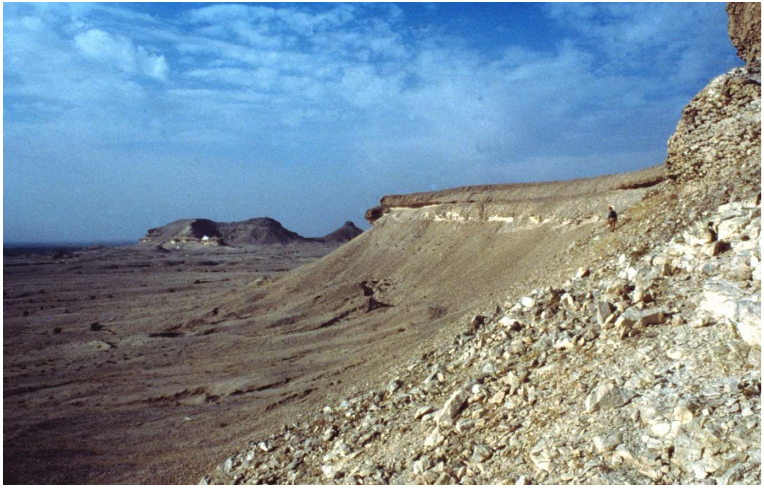
Figure 3.
Rohri Hills: Excavation trench opened in the chert mine RH-862 (Photograph by P. Biagi, 1997).
Figure 3.
Rohri Hills: Excavation trench opened in the chert mine RH-862 (Photograph by P. Biagi, 1997).
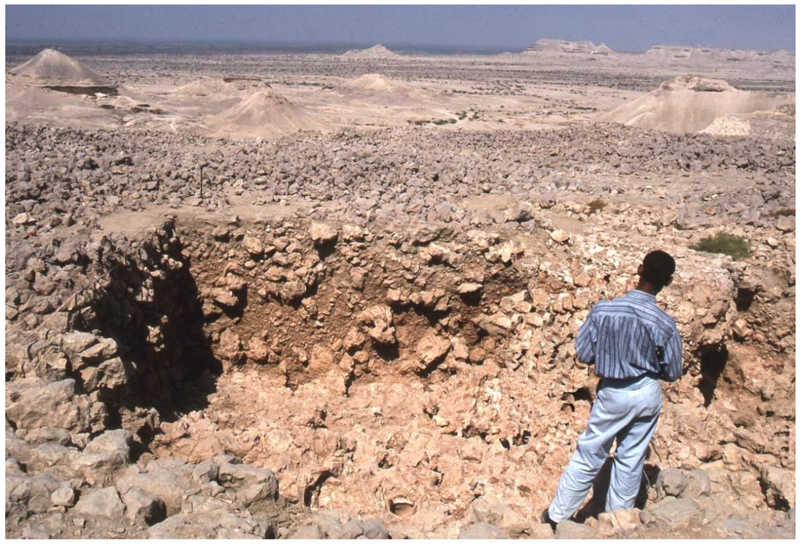
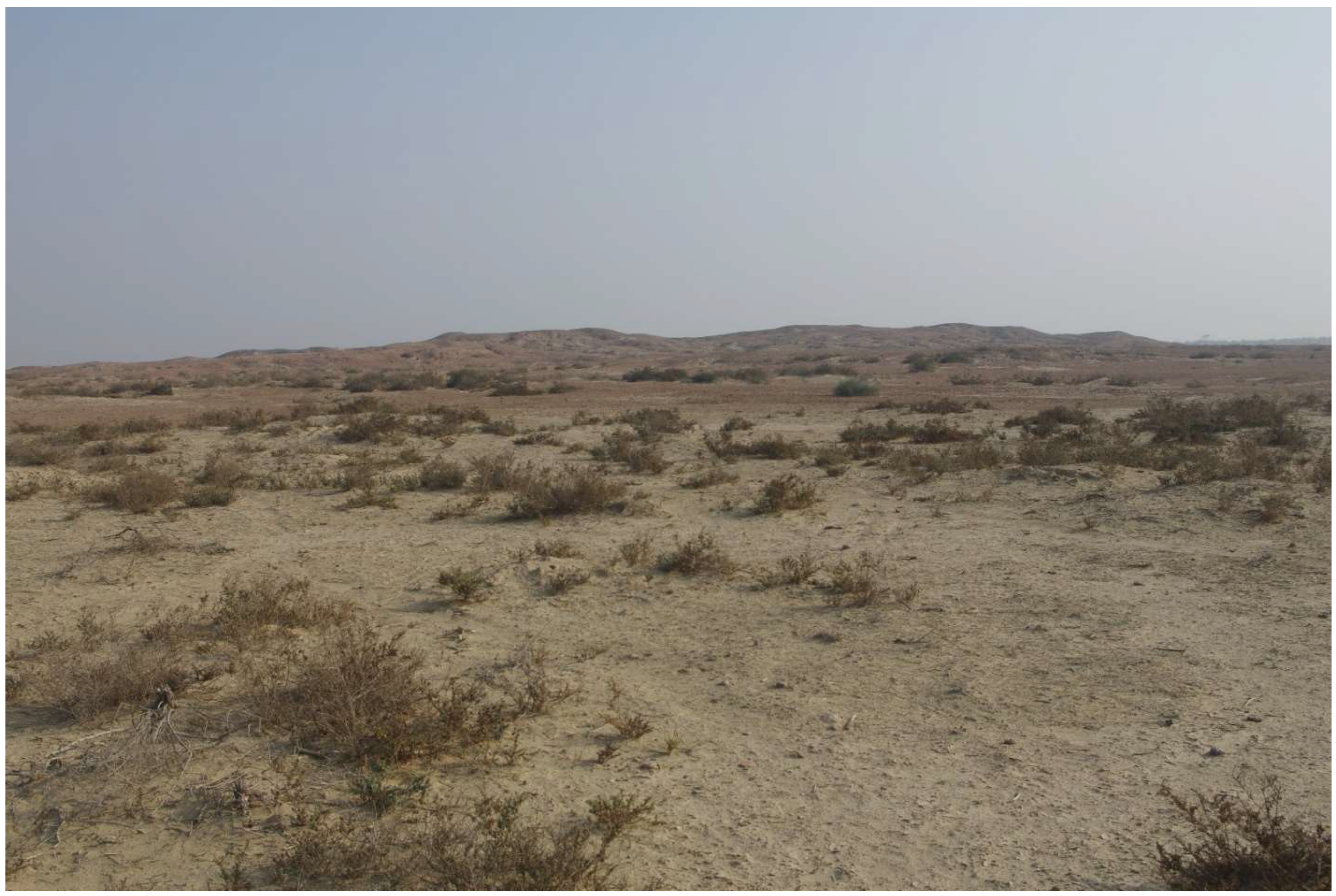
Figure 4.
Kot Diji: The prehistoric site from the Kot Diji fort (Photograph by P. Biagi, 1985).
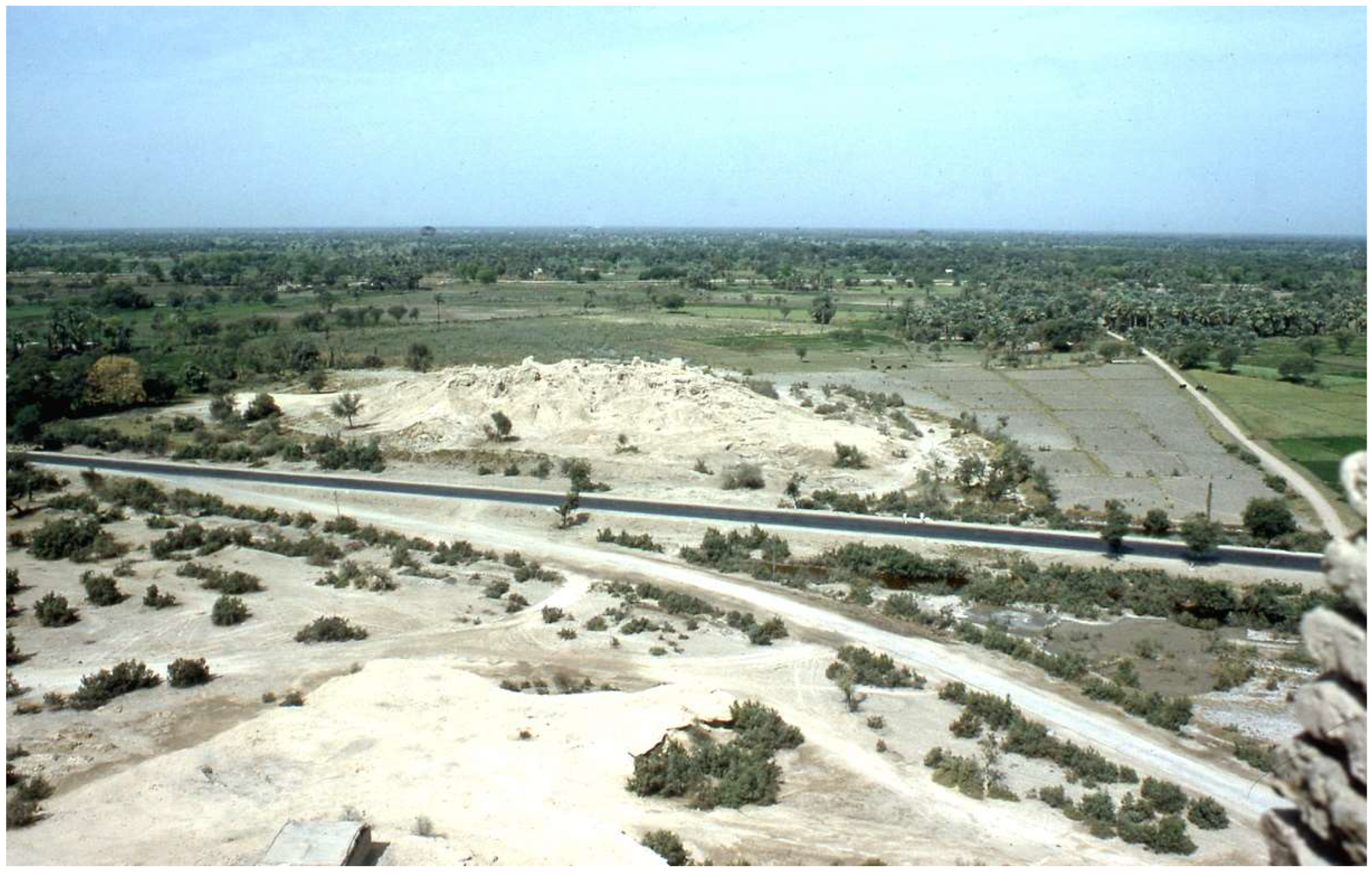
Figure 5.
Rohri Hills: The main groups of chert mines (A-D) located on the terraces east of the shrine of Shadee Shaheed with the location of the excavated mine RH-862. Note the different characteristics of the mining areas and their impressive extension (Satellite image taken in 2013).
Figure 5.
Rohri Hills: The main groups of chert mines (A-D) located on the terraces east of the shrine of Shadee Shaheed with the location of the excavated mine RH-862. Note the different characteristics of the mining areas and their impressive extension (Satellite image taken in 2013).
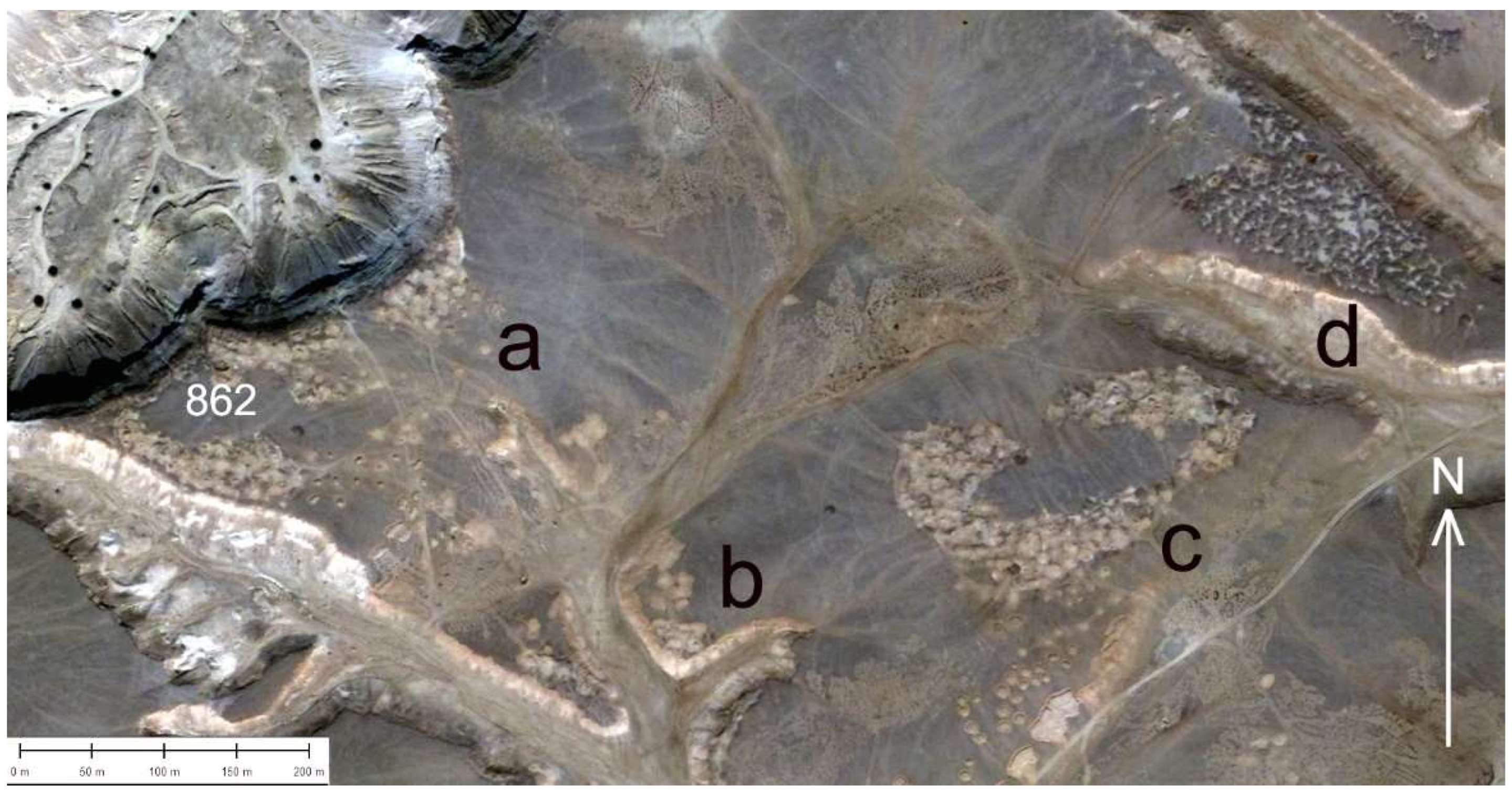
Figure 6.
Rohri Hills: Impressive heap of chert debitage flakes and limestone blocks surrounded by chert mine pits (Photograph by P. Biagi, 1995).
Figure 6.
Rohri Hills: Impressive heap of chert debitage flakes and limestone blocks surrounded by chert mine pits (Photograph by P. Biagi, 1995).
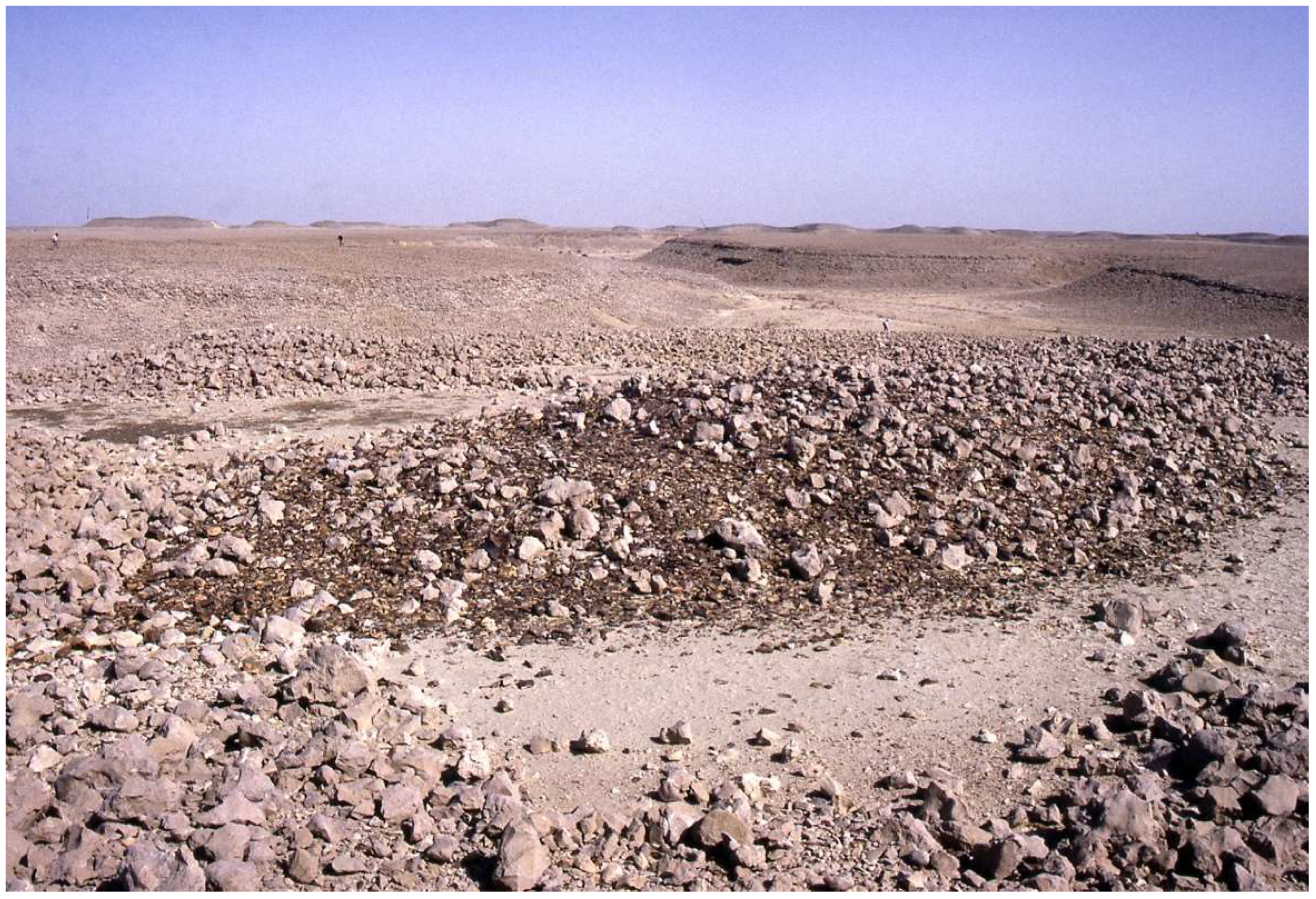
Figure 7.
Different types of flat-bottomed Mohanna boats on the Indus at Rohri (Photograph by P. Biagi, 1997).
Figure 7.
Different types of flat-bottomed Mohanna boats on the Indus at Rohri (Photograph by P. Biagi, 1997).
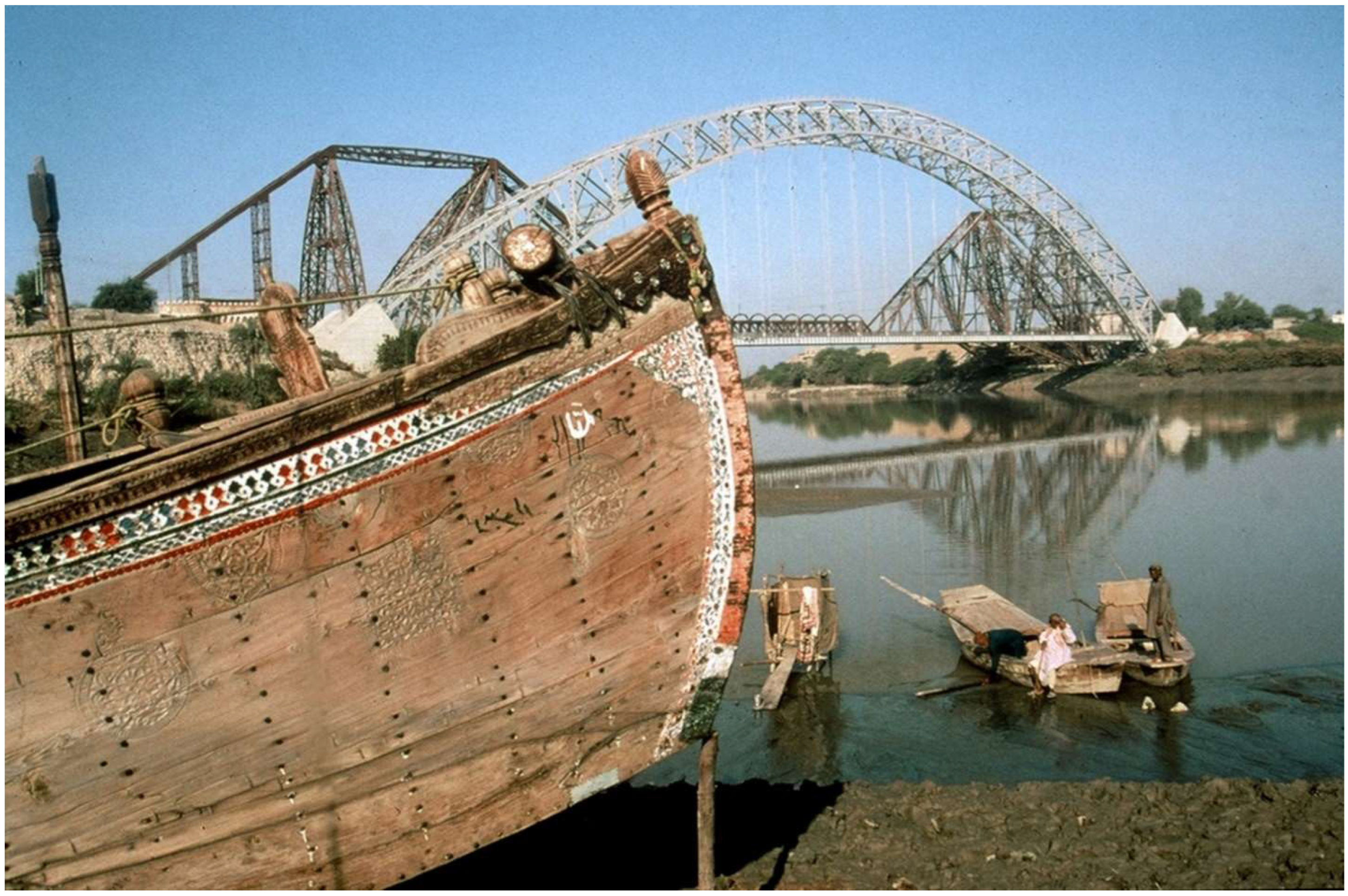
Figure 8.
Mohenjo-Daro: Drain canal near the Great Bath covered with squared limestone blocks (Photograph by P. Biagi, 1985).
Figure 8.
Mohenjo-Daro: Drain canal near the Great Bath covered with squared limestone blocks (Photograph by P. Biagi, 1985).
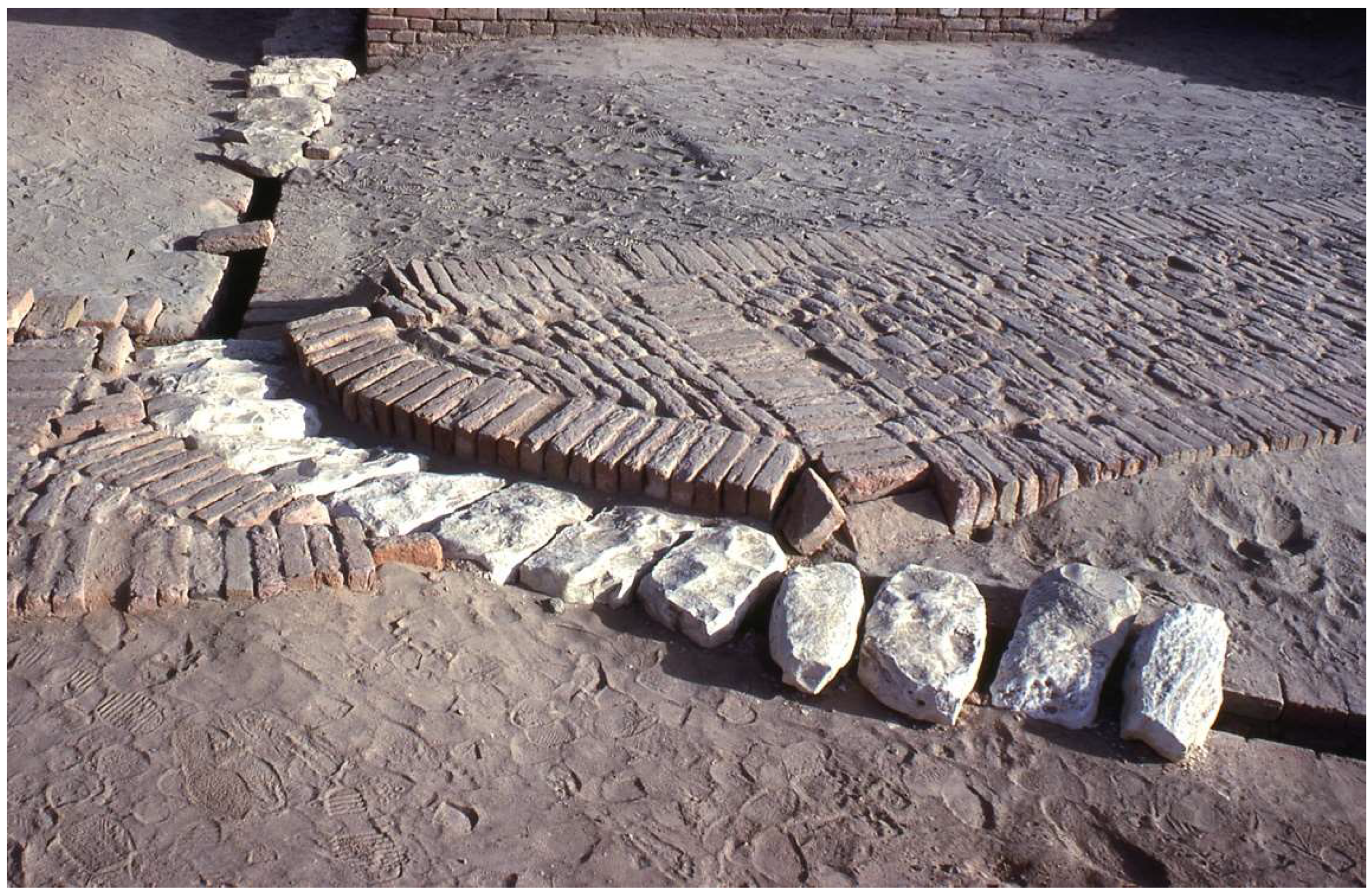
Figure 9.
Ganweriwala (Cholistan): The city from the north-west (Photograph by P. Biagi, 2019).
Disclaimer/Publisher’s Note: The statements, opinions and data contained in all publications are solely those of the individual author(s) and contributor(s) and not of MDPI and/or the editor(s). MDPI and/or the editor(s) disclaim responsibility for any injury to people or property resulting from any ideas, methods, instructions or products referred to in the content. |
© 2024 by the authors. Licensee MDPI, Basel, Switzerland. This article is an open access article distributed under the terms and conditions of the Creative Commons Attribution (CC BY) license (https://creativecommons.org/licenses/by/4.0/).
Copyright: This open access article is published under a Creative Commons CC BY 4.0 license, which permit the free download, distribution, and reuse, provided that the author and preprint are cited in any reuse.


