
Submitted:
24 June 2024
Posted:
25 June 2024
You are already at the latest version
Abstract
The North China Plain is among the regions most afflicted by ground fissure disasters in China. Recent urbanization has accelerated ground fissure activity in the three counties of the northern North China Plain, posing significant threats to both the natural environment and socioeconomic sustainability. Despite the increased attention, a lack of comprehensive understanding persists due to delayed recognition and limited research. This study conducted field visits and geological surveys across 43 villages and 80 sites to elucidate the spatial distribution patterns of ground fissures in the aforementioned counties. By integrating these findings with regional geological data, we formulated a causative model to explain ground fissure formation. Our analysis reveals a concentration of ground fissures near the Niuxi and Rongxi faults, with the former exhibiting the most extensive distribution. The primary manifestations of ground fissures include linear cracks and patch-shaped collapse pits, predominantly oriented in east-west and north-south directions, indicating tensile failure with minimal vertical displacement. Various factors contribute to ground fissure development, including fault activity, ancient river channel distribution, bedrock undulations, rainfall, and ground settlement. Fault activity establishes a concealed fracture system in shallow geotechnical layers, laying the groundwork for ground fissure formation. Additionally, the distribution of ancient river channels and bedrock undulations modifies regional stress fields, further facilitating ground fissure emergence. Rainfall and differential ground settlement serve as triggering mechanisms, exposing ground fissures at the surface. This research offers novel insights into the causative mechanisms of ground fissures in the northern North China Plain, providing valuable scientific evidence for mitigating ground fissure disasters during the urbanization process in the region.
Keywords:
Ground fissures
; North China Plain
; distribution characteristics
; causative mechanism
1. Introduction
Ground fissures refer to the surface ruptures of shallow crustal rocks or soils caused by the combined effects of internal and external forces, as well as human engineering activities [1,2,3,4,5,6,7]. These fissures are widely distributed across the globe, with occurrences reported in Arizona, California, and Texas in the United States [8,9,10,11], the Suzhou-Wuxi-Changzhou region and the Fenwei Basin in China [12,13,14], as well as Iran, Japan, Ethiopia, and other regions that have suffered from the harm of ground fissures [15,16,17,18]. Ground fissures can cause dislocations in linear engineering projects such as railways and highways, collapse of farmland, collapse of buildings, and severance of underground pipelines, severely affecting human daily life and economic development [19,20,21]. Given the complexity of their causes, influenced by various factors, studying the causative mechanisms of ground fissures holds significant importance for the prevention and mitigation of ground fissure disasters.
Based on their causative mechanisms, ground fissures can be classified into tectonic ground fissures, non-tectonic ground fissures, and compound ground fissures [22,23,24]. Tectonic ground fissures refer to those formed by the cracking of overlying rock and soil bodies under the control of tectonic activities. This type of ground fissure is typically found in areas with intense tectonic activities. The main influencing factors include regional tectonics, fault activities, bedrock undulations, earthquake activities, volcanism, and others [25]. The distribution and development characteristics of regionally tectonic ground fissures are determined by the nature of the tectonic stress field within the region, often exhibiting a clustered occurrence pattern. The controlling factors stem from deep-seated endogenic forces such as mantle activities, block movements, crustal movements, and so on [7,26]. Fault-controlled ground fissures are the most common type. These fissures are the result of the long-term creep and sliding of basement faults, which releases energy in the upper loose sedimentary layers. The long-term creep of the faults causes fractures in the shallow rock and soil masses within the fault influence zone, thereby promoting the exposure and expansion of ground fissures [14,17,18]. The undulations in bedrock often lead to uneven distribution of aquifers. As a result of pumping activities, differential subsidence occurs on the ground surface. At the undulations of bedrock, the tensile strength of the soil decreases, making it more susceptible to the formation of ground fissures [27]. The seismic forces or seismic waves generated by earthquakes can cause ruptures within the rock and soil masses, inducing ground fissures of different scales. These ground fissures often inherit the characteristics of strong abruptness associated with seismic activities. Ruptures hidden within the shallow soil masses are prone to expansion and exposure at the surface, forming ground fissures under the influence of later triggering factors [6]. Non-tectonic ground fissures refer to those formed by the cracking of surface rock and soil masses under the influence of external forces and human engineering activities. The main influencing factors include water pumping, mining, rainfall, and special lithology [25]. Over-pumping can cause differential ground subsidence and alter the regional stress field, especially at the edges of subsidence funnels where the strength of rock and soil masses is lower, making ground fissures more likely to occur [28]. Ground fissures caused by mining result from the cracking of the surface due to local collapse or subsidence caused by mining activities. Their formation is directly related to the design and measurement of mining operations and they are primarily exposed at the edges of collapse areas [29]. Rainfall is also an important factor in the development of ground fissures. Under the influence of rainfall, latent fissures within shallow rock and soil masses serve as preferential channels for water infiltration. A large amount of surface water infiltrates and erodes along these latent fissures, leading to the development and expansion of the cracks, and ultimately resulting in the formation of ground fissures on the surface [7]. The presence of rock and soil masses with special properties also has a significant impact on the occurrence of ground fissures. A typical example is the loess widely distributed in the Weihe River Basin in China. This type of soil exhibits strong collapsibility, and under the infiltration of surface water from irrigation or rainfall, the loess undergoes wet collapse and deformation, leading to the formation of ground fissures [13]. However, due to various influencing factors, the genesis of ground fissures often exhibits diversity and complexity. Especially in densely populated areas, a single tectonic or non-tectonic cause cannot accurately explain the genesis mechanism of ground fissures, leading to the emergence of the theory of composite genesis [30,31,32]. This theory suggests that ground fissures are the result of multi-field and multi-scale coupling interactions. Their formation factors include both tectonic and non-tectonic factors. Deep tectonic movements control the morphology and distribution scale of ground fissures, serving as the basis for their formation. Long-term regional stress fields can reduce the strength of rock and soil masses, favoring further crack development. The erosion and transportation effects of hydrodynamic forces can exacerbate the expansion of ground fissures, ultimately leading to their exposure on the surface [33,34,35].
The North China Plain is one of the main distribution areas of ground fissures in China [36]. Peng et al. [6] believed that fault activity is the main factor for the ground fissures in Longyao, North China Plain, and earthquake activity plays a controlling role in the development of ground fissures, while water pumping leads to the exposure of ground fissures on the surface. Xu et al. [5] considered fault activity as the controlling factor for the ground fissures in Anping, North China Plain. Small and medium-sized earthquakes provide direct tensile forces for the ground fissures, and the tensile force of the fissures is directly proportional to the uplift force from deep within the earth, but inversely proportional to the depth of the stratum. Xu et al. [37] discovered a new type of palaeochannel-type ground fissures, which are jointly influenced by the distribution of palaeochannels, sediment properties, and groundwater extraction activities. They also proposed three formation models for palaeochannel-induced ground fissures, which can be used to predict the fine distribution of shallow palaeochannels and the overall migration process of rivers. Li et al. [38] employed geophysical exploration methods and conducted dynamic studies on groundwater, concluding that overexploitation of groundwater has led to large-scale ground settlement in Baixiang, Xingtai, Hebei Province. Differential ground settlement is the main cause of ground fissures in this area. Li et al. [39] studied the spatial and temporal distribution patterns of ground fissures in the North China Plain. The main factors contributing to the occurrence of ground fissures in the North China Plain include seismic structures, overexploitation of groundwater, and ground collapse. The combined effects of these factors have led to the formation of ground fissures in the North China Plain. At the same time, it is believed that the distribution range of ground fissures in the North China Plain is gradually expanding. Xu et al. [40] believe that the ground fissures in Baixiang, North China Plain, belong to tectonic ground fissures. The movement of deep faults causes the activity of shallow faults, thereby promoting the development of ground fissures. The unique "double-element structure" of the regional stratum, with a thick silt layer in the upper part and a thick sand layer in the lower part, provides unique geological conditions for the development of ground fissures.
Although some progress has been made in the study of the formation mechanism of ground fissures in the North China Plain, due to the late discovery and limited research on the ground fissures in the three counties in the northern part of the plain, the development characteristics and formation mechanism of ground fissures in this region are still unclear. The geological conditions in the study area are complex, influenced by factors such as fault control, distribution of palaeochannels, undulations of bedrock, groundwater extraction, and rainfall. A single "tectonic cause" or "non-tectonic cause" cannot fully explain the formation mechanism of ground fissures in this region. To address these issues, this article studies the distribution characteristics of ground fissures in the three counties in the northern part of the North China Plain through field geological surveys and engineering surveying and mapping. Taking five typical villages as examples, it analyzes the deformation and damage characteristics of ground fissures in the study area. Combined with the influence of various factors on the development mechanism of ground fissures, the formation mechanism of ground fissures in the study area is discussed.
Firstly, this article introduces the geological background of the three counties in the northern part of the North China Plain. Subsequently, a brief description and summary of the planar distribution characteristics of ground fissures in the study area are provided. Then, taking five typical villages as examples, the damage characteristics of ground fissures are analyzed. Finally, the influence of various factors on ground fissures in the study area and the formation mechanism of typical ground fissures are discussed.
2. Regional Geological Background
The study area is located in Baoding City in the northern part of North China Plain, including Xiongxian County, Rongcheng county and Anxin county (Figure 1). The terrain gradually slopes from northwest to southeast, with ground elevations ranging from 5 to 26 meters, and an average ground slope of less than 2‰. The study area is located in a semi-arid region, where the groundwater level has been declining for many years. The annual average precipitation is approximately 500mm, while the annual average evaporation is approximately 1500mm. Overall, the precipitation in Xiongxian county is less than that in Rongcheng county and Anxin county [41].
The study area is situated in the northern part of the Jizhong Depression, part of the second-order tectonic unit of the Bohai Bay Basin, which is a Meso-Cenozoic faulted-depressed basin formed on the basement of the North China Craton, trending nearly north-south [42]. Since the Cenozoic era, the regional tectonic stress field of the North China Plate has experienced compression due to the near-field effects of the westward subduction of the Pacific Plate and the Philippine Plate, as well as the far-field effects of the eastward compression from the Indian Ocean Plate. This compression has resulted in active sinistral strike-slip offsets along the normal faults striking northeast (NE) and northwest (NW) in the region [6]. The main faults within the study area include the Rongxi fault (F1), Rongdong fault (F2), Rongcheng fault (F3), Niuxi fault (F4), and Niudong fault (F5) (Figure 1). All five faults are normal faults; however, the Rongxi fault, Rongdong fault, and Niuxi fault strike NW, while the Rongcheng fault strikes NE, and the Niudong fault strikes southeast (SE) (Figure 2) [43]. Notably, the Niuxi and Niudong faults are characterized by greater depths and longer extensions, significantly influencing the regional structure. They are approximately 70 km long, with about 35 km of their lengths lying within the study area [44].
Within the study area, groundwater is primarily composed of porous water from loose rocks, mainly stored in Quaternary loose deposits. Due to the increase in production and living activities, the groundwater level in the study area has been decreasing year by year from 1991 to 2016 [45], with groundwater overexploitation throughout the entire region. Among the counties, the decline in groundwater level is relatively small in Anxin county and Rongcheng County, while the decline is the most significant in Xiongxian County. Specifically, the shallow groundwater level in Xiongxian county decreased by approximately 4-9 meters between 1991 and 2016, and the deep confined water level experienced a significant decline, falling by about 30 meters over the past 25 years (Figure 3).
The study area is filled with a relatively thick layer of Cenozoic strata, with a sedimentary thickness ranging from 800 to 3000 meters. The exposed strata on the surface of the region consist of the loose Quaternary layer. Below the Quaternary layer, the strata include the Neogene, Paleogene, Ordovician-Cambrian, Middle-Upper Proterozoic, and Archean systems. During the early Eocene, the region began to experience large-scale faulting, resulting in significant accumulation of sediments in the Quaternary strata within the study area. The thickness of the loose overlying layer ranges from 350 to 560 meters, with a minimum thickness of approximately 192 meters and a maximum thickness of nearly 500 meters [41]. These strata are primarily composed of clayey soil, silt, and sandy soil [42]. Based on a comprehensive analysis of data from two boreholes, D1 and D2, the Cenozoic strata in the study area have been determined (Figure 4).
Through field investigations, a total of 80 ground fissures have been discovered within the study area, mainly concentrated in Xiongxian county and Rongcheng County. Specifically, there are 58 ground fissure sites in Xiongxian county, 20 in Rongcheng County, and 2 in Anxin County. These ground fissures are widely distributed near the Niuxi fault, located at the intersection of the western side of Xiongxian county and the eastern side of Rongcheng county. The earliest ground fissure appeared in 1990, and their occurrences gradually increased after 2008. The ground fissures in the study area are mainly developed in woods, farmland, and along river channels, with a small portion developing in residential areas. Ground fissures developed in woods generally do not affect residents' production and life, therefore they are not usually filled in and are mostly visible during investigations. However, due to farming and backfilling activities, some ground fissures developed in farmland have become invisible. Only a small portion of them become exposed during rainy seasons or during irrigation of farmland.
3.Distribution Characteristics of Ground Fissures
The ground fissures developed within the study area vary in size and are mainly categorized into two forms: linear cracks and sheet-like collapse pits (Table 1). There are 39 occurrences of linear cracks and 41 occurrences of sheet-like collapse pit clusters. For convenience of statistical analysis, multiple collapse pits within a certain area are grouped together as one occurrence. The majority of the linear ground fissures are small-scale, with lengths mostly ranging from 0 to 100m. Six of them are longer than 100m, with the maximum crack length reaching 2200m. The widths vary from 0.2m to 6.6m, and the extension directions are mostly east-west and north-south. A total of 41 occurrences of sheet-like collapse pit clusters have been identified, most of which occur in clusters with no apparent directionality. The lengths of the collapse pits range from 0.7m to 9.6m, and the widths vary from 0.3m to 6.5m.
4.Characteristics of Typical Ground Fissure Damage
Based on field visits and geological surveys, nine ground fissures with distinct damage characteristics have been identified within the study area (Table 2). To explain the formation mechanism of ground fissures in the study area, we have created large-scale plan distribution maps for five villages with typical ground fissure development. These maps provide a detailed description of the spatial distribution characteristics of the ground fissures, as well as the damage features observed on the surface and buildings.
4.1 Ground Fissures in Zhangweizhuangtou Village
Based on field visits and geological surveys, the ground fissures in this region are predominantly concentrated in the farmland and wooded areas west of Zhangweizhuangtou village in Xiongxian county (Figure 5). The earliest ground fissure emerged in 2013, and concentrated in 2014 and 2016.In recent years, new collapse pits have appeared after each heavy rainfall. Although collapse pits in the farmland are often filled in due to farming activities, the ground fissures in the woods have no direct impact on the villagers' normal production and daily lives. Consequently, the linear cracks and collapse pits on the ground surface are often left untreated and are still visible during surveys. During this investigation, we discovered a total of three linear cracks (Figure 5- b, f, g) and 25 collapse pits. The lengths of the collapse pits range from 1.5 to 9.6 meters, their widths from 0.7 to 6.5 meters, and their depths from 0.3 to 1.7 meters. Visible traces of water erosion can be observed on the walls of the collapse pits. Due to the collapse, some pits contain fallen trees with exposed roots visible on the surface. The strike directions of the collapse pits are inconsistent and show no apparent pattern.
Figure 5-a shows a cluster of bead-like collapse pits arranged in a linear pattern, measuring 35 meters in length and trending at 93 degrees. The western side of the fissure is closely adjacent to residential houses, posing a potential hazard to buildings in the area.In Figure 5-b, the ground fissure extends for 16.5 meters with a strike of 185 degrees. Poplar trees were planted here eight years ago, and the fissure emerged after the planting.Figure 5-f depicts a ground fissure measuring 24.4 meters in length and trending at 77 degrees. Inside the fissure, a poplar tree has tilted and collapsed. This fissure is located adjacent to a residential area.The f1 ground fissure shown in Figure 5-g emerged in 2013, trending at 180 degrees, with a length of 127 meters, an average cracking width of 1.5 meters, and an average depth of 0.7 meters. This fissure developed in an open space between the woods and farmland, accompanied by multiple collapse pits. Investigations have revealed that this ground fissure (Figure 5-g) has been filled in multiple times but reappears after rainfall, indicating its strong activity.
4.2 Ground Fissures in Beihoutai Village
The ground fissure in this area is located in Beihoutai village, Rongcheng county, with an extension length of 2.2 kilometers. It longitudinally traverses the Rongxi fault (F1) and is closely adjacent to the Nanjuma River on the eastern side, with a nearly north-south river trend (Figure 6). The ground fissure passes through Beihoutai village, Nanhoutai village, and Jiaguang village in sequence from south to north, causing the most significant damage to Beihoutai village. Currently, there is no visible trace of this ground fissure on the surface, and it is mainly detected in the walls of residents' houses. Its overall trend is first to pass through the houses in Beihoutai village in a north-south direction, and then through the houses in Nanhoutai village and Jiaguang village in a southwest direction.
The ground fissures have caused cracks in a total of 32 houses in the local residential areas. The cracks in the walls of the houses mainly appear vertically, penetrating through the entire wall, with the widest cracks reaching 2-3cm (Figure 6-b). Some residents in the area have also reported ground subsidence and cracking inside their houses (Figure 6-e,f,g), with subsidence of approximately 2-3cm and a maximum slope of about 2° at the subsidence center. The ground cracks trend at 8°, approximately north-south. The earliest recorded occurrence of house cracking was in 2006, and the ground subsidence rate in the area is 10-20mm/a (Figure 11). However, there has been no significant overall subsidence observed in the houses, and there are no apparent vertical dislocations in the walls. Currently, some residents have taken simple reinforcement measures on the walls of their houses, but the recurrence of cracks indicates that the ground fissures in this area are still active and pose a significant potential hazard to residents. According to local villagers, there is a ground fissure running through a farmland in the northwest corner of Beihoutai village, measuring 65m in length and trending nearly east-west. Despite multiple attempts at filling, the fissure continues to reopen repeatedly.
4.3 Ground Fissures in Longwanxi Village
The ground fissures in this area mainly appear in the form of collapse pit clusters in the forest south of Longwanxi village, Xiong county (Figure 7). A total of three linear fissures have been identified (Figure 7-a, d, g), all of which exhibit an "L" shape, with lengths of 24m, 17m, and 29m respectively, and no obvious regularity in their strike directions. Eighteen collapse pits have been discovered in this area, with lengths ranging from 1.2 to 9 meters, widths from 0.6 to 7 meters, and depths from 0.5 to 1.6 meters. These pits are concentrated on the east and west sides of the forest, with an overall southeast trend. Some of the pits (Figure 7-e, h) are developed near the roots of poplar trees. The western side of this ground fissure cluster is adjacent to the Daqing River, which flows towards the southeast. The forest in this area was planted in recent years, therefore, the collapse pit cluster and ground fissures should have also appeared in recent years. The flow direction of the Daqing River is basically consistent with the overall trend of the collapse pit cluster. The surface soil is arable soil and relatively soft. It is speculated that the emergence of the collapse pit cluster and ground fissures in this area is related to the stratum properties and the Daqing River.
4.4 Ground fissures in Beizhang village
This ground fissure is located in the center of Beizhang village, extending approximately north-south with a length of 260m (Figure 8). According to field visits and investigations, this ground fissure occurred 30 years ago, trending northeast. After its occurrence, it was filled in by local villagers, who then built houses on top of it. Since 1990, cracks have appeared in the houses and their severity has gradually increased. Currently, there is no visible trace of this ground fissure on the surface, but the damage caused by it can be seen in the walls, floors, steps, and within the woods of the houses. The cracks in the walls of the houses mainly appear vertically and penetrate through the entire wall, with the widest cracks reaching 2-3cm. A diagonal crack (Figure 8-f) about 60cm long can be seen on the west wall inside a resident's house, and a diagonal stepped-through crack can be seen on the east wall of a neighbor's house on the west side (Figure 8-b). Although the villagers have made simple repairs to the houses (Figure 8-d, e, g), the walls have continued to crack, indicating that the ground fissure is still active. The southernmost end of the crack is within a straight-line distance of less than 30m from the high-speed railway, posing a significant potential impact on the railway.
4.5 Ground Fissures in Dongangezhuang Village
The ground fissure cluster in this area is located in the woods north of Dongangezhuang village, Xiong county (Figure 9). This ground fissure occurred during the rainy season of 2013. Three ground fissures and two collapse pits have developed here. F7 (Figure 9-c) is a polyline-shaped ground fissure consisting of a main fissure and two branch fissures. The main fissure is 46.7m long, with a maximum width of 2.47m and a maximum depth of 1.15m, trending at 70°. The lengths of the two branch fissures are 11.2m and 20.7m, trending at 33° and 147°, respectively. According to the investigation, this ground fissure first appeared in 2015, reaching a depth of up to 8m. It was then filled and planted with poplar trees around 2018. F8 (Figure 9-d) is a straight-line ground fissure, approximately 33m long, with a maximum width of 1.97m and a maximum depth of 1.18m, trending at 19°. F9 is a trough-shaped ground fissure, approximately 23m long, with a maximum width of 5.6m and a maximum depth of 3.1m, trending at 189°. Inside the trough, there is a exposed pipeline leading straight to a sewage pond in front and passing over it. There are no obvious displacement or vertical misalignment phenomena on both sides of the three ground fissures. A comparison of this investigation's results with previous surveys in the area reveals that there is no significant increase in the activity of these three ground fissures. However, there has been a change in the maximum visible depth of the fissures, which is primarily attributed to erosion by rainfall based on initial analysis.
5 Discussion
The distribution of ground fissures in the study area is extensive, and the formation and development of ground fissures involve multiple factors such as fault activities, bedrock undulations, distribution of ancient river channels, and water extraction-induced subsidence. Through the analysis of the destruction characteristics of typical ground fissures, it is found that the main controlling factors for the formation of ground fissures are not the same. The main controlling factors lead to the generation of ground fissures, control the distribution and scale of ground fissures, and the inducing factors further promote the development of ground fissures, ultimately exposing them to the surface in different forms. Based on the different main controlling factors, the genesis mechanism of ground fissures in the study area is discussed in four scenarios.
5.1 Relationship Between Ground Fissures and Fault Activities
The main faults in the study area include Rongxi fault, Rongdong fault, Rongcheng fault, Niuxi fault, and Niudong fault (Figure 1). Ground fissures are concentrated near the Niuxi fault and Rongxi fault, with the most extensive distribution along the Niuxi fault. Overall, the ground fissures have good continuity and are arranged linearly. Zhangweizhuangtou village is the most typical area for the development of ground fissures near this fault. No ground fissures are developed near the Rongcheng fault, while ground fissures are sporadically developed near the Rongdong fault and Niudong fault, with an unobvious linear relationship.
The area from Beihoutai to Nanhoutai villages on the northern side of the Rongxi fault is the region with the most severe development of house cracks in the study area. However, these house cracks do not exhibit significant vertical displacements. Apart from Beihoutai and Nanhoutai, the number of ground fissures in the surrounding areas along the Rongxi Fault is also limited. Although there is an ancient river channel below the ground fissures in the Beihoutai-Nanhoutai village area (Figure 12), the development characteristics of these ground fissures are significantly different from those of the ancient river channel-type ground fissures [37]: no collapse pits are exposed along the cracks on the ground surface, the overall directionality of the ground fissures is good, and they extend to a considerable length. Additionally, cracks in the walls repeatedly appear, indicating that fault activity is still the primary factor.
Based on field investigations, ground fissures in the Zhangweizhuangtou area often appear after heavy rainfall, and some filled cracks and collapse pits also repeatedly reopen after rainfall. The period from June to August, when rainfall is concentrated in this area, also coincides with the time when ground fissures emerge on a large scale. Therefore, rainfall is an important factor affecting the occurrence of ground fissures in this region. Since fault activities in the study area are weak, and the area is filled with a thick loose Quaternary layer, fault activities are not sufficient to directly cause ground fissures to emerge on the surface, and exposed ground fissures do not exhibit significant vertical displacements. The main cause of ground fissures in Zhangweizhuangtou is the early activity of the Niuxi fault, which results in latent tensile fractures in the shallow Quaternary loose soil layer. These latent fractures become convenient channels for surface water infiltration. Under the influence of heavy rainfall, surface water infiltrates through soil fractures and large voids created by tree roots, leading to the erosion and transport of the soil layer around the cracks. Gradually, the cracks expand to form cavities. When erosion creates caves and the overlying soil layer can no longer support its own weight, the cracks further develop, forming beaded collapse pits (Figure 10). As the infiltrating water continues to erode, the cracks gradually expand and ultimately form linear fissures visible on the surface.
5.2 Relationship Between Ground Fissures and Ground Settlement
The significant increase in industrial water usage in the 1990s has led to a continuous decline in the groundwater level in the study area over the past 25 years (Figure 3), resulting in widespread ground subsidence. The areas with severe ground subsidence in the study area are mainly concentrated in Xiongxian county and Rongcheng county, while Anxin county is relatively stable. Among them, the northern part of Xiongxian county is the area with the most significant variation in ground subsidence rate (Figure 11). The main cause of ground subsidence is the dehydration and compression of the unconsolidated clayey soil in the Quaternary period due to groundwater extraction. Overexploitation of groundwater can lead to a decline in the water level of the aquifer, which reduces pore water pressure and increases effective stress, resulting in the narrowing of pores between particles and the destruction of particle structure, affecting the movement and arrangement of particles. Macroscopically, this process manifests as uneven ground subsidence [37].
Differential subsidence is the dynamic source and fundamental cause of the formation of ground fissures. The formation of ground fissures is a process of stress and strain accumulation and dissipation caused by differential subsidence of the ground. During this process, latent cracks develop in the stress concentration areas of the shallow soil layer, laying the foundation for the later emergence of cracks on the surface. Especially at the edge of the subsidence funnel, due to differential subsidence of soil layers, local tensile stress concentration occurs. Since the tensile strength of the soil layer is extremely low, it is highly susceptible to damage and the formation of ground fissures [25].
The study area has a developed water system with widespread distribution of ancient river courses. In some regions, the bedrock exhibits significant fluctuations, and the distribution of ground fissures in these areas does not align with the distribution of faults, indicating that the formation of ground fissures in these regions is less influenced by faults but closely related to the distribution of ancient river courses and changes in terrain (Figure 12).
Differential settlement of strata is the basis for the formation of this type of ground fissures. The difference in thickness of the compressible layer in areas with fluctuating bedrock is prone to causing uneven settlement, which can easily lead to the formation of ground fissures. Dong'an Gezhuang and Beizhang Village are located far away from fault development zones, therefore, the influence of faults on ground fissures in these areas is relatively small, and changes in terrain have an important impact on the formation of ground fissures.
5.2.1 Relationship Between Ground Fissures and Paleochannel
Paleochannels formed by river changes are also one of the important factors that induce ground fissures. The study area is an alluvial plain with numerous water systems, relatively flat terrain, slow river flow, and weak incision, all of which favor river changes and the generation of ground fissures. Longwanxi village is a typical example of ground fissures associated with paleochannels, where three linear fissures and 18 collapse pits have been identified. These ground fissures are far from faults and are mainly distributed along the banks of the Daqing river, often manifesting as collapse pits. The lengths of the linear fissures are generally small, not exceeding 30 meters. Ground fissures associated with paleochannels are significantly different from those controlled by faults. They are mainly distributed at the shoulders of paleochannels and are caused by uneven subsidence of the overlying soil and rock mass due to groundwater extraction, resulting in tensile stress concentration areas above the shoulders of the ancient river courses and the formation of latent fissures. Further pumping of water leads to increased uneven ground subsidence, and when the regional tensile stress exceeds the tensile strength of the soil, latent fissures develop until they emerge at the surface to form ground fissures (Figure 13).
5.2.2 Relationship between Ground Fissures and Bedrock Relief
Undulation of bedrock is also one of the important factors that influence the development of ground fissures. The study area is home to numerous ancient buried mountains controlled by faults, such as the Niutuozhen bulge, Rongcheng bulge, Anxin bulge, and Gaoyang bulge. The significant elevation difference in the bedrock surface is a key factor driving the formation of ground fissures. Dongangezhuang village has developed three linear fissures and two collapse pits, with two of the linear fissures trending north-south and the other trending east-west, displaying no obvious overall directional pattern. This area is located on the Niutuozhen bulge between the Niuxi fault and the Niudong fault, in a region where the bedrock is buried at its shallowest depth. In areas with bedrock uplift, intense groundwater extraction can easily lead to uneven settlement of the overlying loose strata. This uneven settlement primarily occurs at the bedrock ridge, with greater settlement occurring far from the ridge and less settlement near it. Vertical differential compression can cause horizontal movement of the overlying aquifer material, forming a tensile stress zone in the thinnest part of the aquifer, thereby promoting the formation of ground fissures (Figure 14).
In addition to the elevation difference of the bedrock surface, the undulation of the bedrock surface is also an important factor leading to ground fissures. The ground fissures in Beizhang Village are mainly developed in the walls of houses, with cracking patterns including vertical and oblique cracking. Oblique cracking is the dominant form (Figure 9- b, c, d, e, f). There is no obvious dislocation at the fissures, and they are all tensile-type fissures with an oblique tensile stress mode. Beizhang Village is located in the area with the largest bedrock undulation in the entire study area. The density of bedrock burial depth contours increases rapidly from west to east (Figure 12). Within a distance of 1500 meters, the maximum elevation difference of bedrock burial depth can reach 1000 meters, and the bedrock slope can reach 67%. The rapid change in bedrock burial depth provides a terrain basis for uneven settlement due to pumping, and the occurrence of uneven settlement will form local tensile stress zones, thus promoting the formation of ground fissures (Figure 15).
6.Conclusions
This paper takes the ground fissures in three counties in the northern part of the North China Plain as the research object. Through field geological surveys, engineering surveying and mapping, and other means, the distribution and damage characteristics of ground fissures are studied. Combined with the regional geological background, the causes of ground fissures are discussed. The main conclusions obtained are as follows:
(1) Within the study area, a total of 80 ground fissure disaster sites were identified: 39 linear fissures and 41 sheet-like collapse pits. The extension directions of the linear fissures are mostly east-west and north-south, often accompanied by the appearance of sheet-like collapse pits nearby, with the maximum length of the pits reaching 9.6 meters. The ground fissures are concentrated near the Niuxi fault and Rongxi fault, with the most extensive distribution along the Niuxi fault.
(2) The ground fissures within the study area have caused severe damage to houses, woodlands, and farmland. The linear fissures developed on the ground surface are tensile-type fissures, and traces of water erosion can often be seen inside them. The fissures developed on the walls of houses are mainly horizontally tensile and obliquely tensile, and there is no significant vertical dislocation in the ground fissures in the region. Zhangweizhuangtou Village is the area with the most severe development of linear fissures and collapse pits on the ground surface within the study area, while Beitai Village has experienced the most severe damage to houses caused by ground fissures.
(3) The ground fissures in the study area are influenced by the combined effects of fault activity, distribution of palaeochannels, bedrock undulation, rainfall, and ground subsidence. The first three factors are the main controlling factors that determine the distribution and scale of ground fissures. Fault activity leads to the formation of latent crack systems in shallow rock and soil masses, which is the basis for the formation of ground fissures. The distribution of palaeochannels and bedrock undulation provide terrain conditions for the occurrence of ground fissures, altering the regional stress field and leading to a decrease in the tensile strength of the soil. Rainfall and differential ground subsidence are inducing factors that exacerbate the development and expansion of ground fissures.
Author Contributions
Conceptualization, C.X. and M.Z.; methodology, C.X.; software, C.X.; formal analysis, C.X.; investigation, C.X., M.Z., F.W. (Feiyong Wang), C.H., G.L., F.W. (Fujiang Wang); resources, C.X.; data curation, C.X.; writing—original draft preparation, C.X.; writing—review and editing, M.Z., Z.Z.; visualization, C.X.; project administration, M.Z.; funding acquisition, N.X. All authors have read and agreed to the published version of the manuscript.
Funding
This work was funded by the Xiongan New Area Science and Technology Innovation Special Project (2022XAGG0400).
Institutional Review Board Statement
Not applicable.
Informed Consent Statement
Informed consent was obtained from all subjects involved in the study.
Data Availability Statement
The original contributions presented in the study are included in the article, further inquiries can be directed to the corresponding authors.
Conflicts of Interest
The authors declare no conflicts of interest.
References
- Rogers, T.H. Active extensional faulting north of Hollister near the Calaveras fault zone. B. Seismol. Soc. Am. 1967, 57, 813–816. [Google Scholar] [CrossRef]
- Lee, C.F.; Zhang, J.M.; Zhang, Y.X. Evolution and origin of the ground fissures in Xian, China. Eng. Geol. 1996, 43, 45–55. [Google Scholar] [CrossRef]
- Li, X.; Wang, S.J.; Liu, T.Y.; Ma, F.S. Ground surface movement and fissures induced by underground mining in the Jinchuan Nickel Mine. Eng. Geol. 2004, 76, 93–107. [Google Scholar] [CrossRef]
- Burbey, T.J. Mechanisms for earth fissure formation in heavily pumped basins. In: Proceedings of the 8th International Symposium on Land Subsidence. International Association of Hydrological Sciences Publication, Querétaro, Mexico, Date of Conference (16 10 2010).
- Xu, J.; Meng, L.; An, H.; Wang, L. The bending mechanism of Anping ground fissure in the Hebei Plain, North China. Environ Earth Sci. 2015, 74, 6859–6870. [Google Scholar] [CrossRef]
- Peng, J.; Xu, J.; Ma, R.; Wang, F. Characteristics and mechanism of the Longyao ground fissure on North China Plain, China. Eng. Geol. 2016, 214, 136–146. [Google Scholar] [CrossRef]
- Peng, J.; Wang, F.; Cheng, Y.; Lu, Q. Characteristics and mechanism of Sanyuan ground fissures in the Weihe Basin, China. Eng. Geol. 2018, 247, 48–57. [Google Scholar] [CrossRef]
- Rucker, L.M.; Fergason, C.K.; Panda, B.B. Subsidence characterization and modeling for engineered facilities in Arizona, USA. PIAHS. 2015, 372, 59–62. [Google Scholar] [CrossRef]
- Jachens, Robert C.; Holzer, Thomas L. Differential compaction mechanism for earth fissures near Casa Grande, Arizona. Geol. Soc. Am. Bull. 1982, 93, 998–1012. [CrossRef]
- Carpenter, C.M. Continuous monitoring of an earth fissure in Chino, California, USA – a management tool. PIAHS. 2015, 372, 291–296. [Google Scholar] [CrossRef]
- Kreitler, C.W. Fault control of subsidence, Houston, Texas. Ground Water. 1977, 15, 203. [Google Scholar] [CrossRef]
- Zhang, Y.; Wang, Z.; Xue, Y.; Wu, J.; Jun, Y. Mechanisms for earth fissure formation due to groundwater extraction in the Su-Xi-Chang area, China. B. Eng. Geol. Environ. 2016, 75, 745–760. [Google Scholar] [CrossRef]
- Zang, M.; Peng, J.; Qi, S. Earth fissures developed within collapsible loess area caused by groundwater uplift in Weihe watershed, northwestern China. J.Asian Earth.Sci. 2019, 173, 364–373. [Google Scholar] [CrossRef]
- Wang, F.; Peng, J.; Chen, Z.; Wang, Q.; Meng, Z.; Qiao, J.; Zhao, J. Development characteristics and mechanisms of damage-causing urban ground fissures in Datong City. China. Eng. Geol. 2020, 271, 105605–105605. [Google Scholar] [CrossRef]
- Ghazifard, A.; Moslehi, A.; Safaei, H.; Roostaei, M. Effects of groundwater withdrawal on land subsidence in Kashan Plain, Iran. B. Eng. Geol. Environ. 2016, 75, 1157–1168. [Google Scholar] [CrossRef]
- Reclaimed Land Geological Research Group. Ground failures on reclaimed land during the 2011 Tohoku earthquake: A case study in Urayasu City, Japan. Quat. Int. 2016, 397, 555–562. [Google Scholar] [CrossRef]
- Ayalew, L.; Yamagishi, H.; Reik, G. Ground cracks in Ethiopian Rift Valley: facts and uncertainties. Eng. Geol. 2004, 75, 309–324. [Google Scholar] [CrossRef]
- Williams, F.M.; Williams, M.A.J.; Aumento, F. Tensional fissures and crustal extension rates in the northern part of the Main Ethiopian Rift. J.Afr Earth.Sci. 2004, 38, 183–197. [Google Scholar] [CrossRef]
- Youssef, M.A.; Sabtan, A.A.; Maerz, H.N.; Zabramawi, A.Y. Earth Fissures in Wadi Najran, Kingdom of Saudi Arabia. Nat. Hazards. 2014, 71, 2013–2027. [Google Scholar] [CrossRef]
- Peng, J.; Meng, L.; Lu, Q.; Deng, Y.; Meng, Z. Development characteristics and mechanisms of the Taigu–Qixian earth fissure group in the Taiyuan basin, China. Environ.Earth.Sci. 2018, 77, 1–20. [Google Scholar] [CrossRef]
- Zang, M.; Peng, J.; Xu, N.; Jia, Z. A probabilistic method for mapping earth fissure hazards. Sci.Rep. 2021, 11, 8841. [Google Scholar] [CrossRef]
- Kreitler, C.W. Fault control of subsidence, Houston, Texas. Ground Water. 2006, 15, 203–214. [Google Scholar] [CrossRef]
- Yi, X. A discussion on the ground subsidence and the genesis of ground fissure in Xi’an city. Earthquake. 1984, 4, 50–54. (in Chinese). [Google Scholar]
- Peng, J.; Qiao, J.; Leng, Y.; Wang, F.; Xue, S. Distribution and mechanism of the ground fissures in Wei River Basin, the origin of the Silk Road. Environ Earth Sci. 2016, 75, 71. [Google Scholar] [CrossRef]
- Wang, F. Study on the Development Characteristics and Formation Mechanism of Ground Fissure Hazard. Doctoral Dissertation, Chang'an University, Xi'an, China, 2021. (in Chinese). [Google Scholar] [CrossRef]
- Li, G.; Wang, F.; Gong, X.; Zhang, Y.; Wang, F. Characteristics and Formation Mechanism of Water-Eroded Ground Fissures in the Weihe Basin of China. Water. 2023, 15, 2198. [Google Scholar] [CrossRef]
- Yang, C.; Lv, S.; Hou, Z.; Zhang, Q.; Li, T.; Zhao, C. Monitoring of Land Subsidence and Ground Fissure Activity within the Su-Xi-Chang Area Based on Time-Series InSAR. Remote Sens. 2022, 14, 903–903. [Google Scholar] [CrossRef]
- Conway, D.B. Land subsidence and earth fissures in south-central and southern Arizona, USA. Hydrogeol. J. 2016, 24, 649–655. [Google Scholar] [CrossRef]
- Kalogirou, E.E.; Tsapanos, M.T.; Karakostas, G.V.; Marinos, P.V.; Chatzipetros, A. Ground fissures in the area of Mavropigi Village (N. Greece): Seismotectonics or mining activity? Acta.Geophys. 2014, 62, 1387–1412. [Google Scholar] [CrossRef]
- Peng, J.; Sun, X.; Lu, Q.; Meng, L. Characteristics and mechanisms for origin of earth fissures in Fenwei basin, China. Eng. Geol. 2019, 266, 105445. [Google Scholar] [CrossRef]
- Wang, F.; Peng, J.; Lu, Q.; Cheng, Y.; Meng, Z.; Qiao, J. Mechanism of Fuping ground fissure in the Weihe Basin of northwest China: fault and rainfall. Environ.Earth.Sci. 2019, 78, 1–10. [Google Scholar] [CrossRef]
- Jia, Z.; Peng, J.; Lu, Q.; Meng, L.; Meng, Z.; Qiao, J.; Wang, F.; Zhang, J. Characteristics and genesis mechanism of ground fissures in Taiyuan Basin, northern China. Eng. Geol, 2020; 275, 105783. [Google Scholar] [CrossRef]
- Howard, K.W.F.; Zhou, W.F. Overview of ground fissure research in China. Environ. Earth Sci. 2019, 78, 97. [Google Scholar] [CrossRef]
- Wang, F.; Peng, J.; Meng, Z.; Qiao, J.; Wen, H.; Ma, P.; Liu, Y.; Jia, Z.; Zhao, J. The origin and impact of the Shizhuang ground fissure, Yingxian area, Datong Basin, China. Eng. Geol. 2019, 261, 105283. [Google Scholar] [CrossRef]
- Brunori, C.A.; Bignami, C.; Albano, M.; Zucca, F.; Samsonov, S.; Groppelli, G.; Norini, G.; Saroli, M.; Stramondo, S. Land subsidence, Ground Fissures and Buried Faults: InSAR Monitoring of Ciudad Guzmán (Jalisco, Mexico). Remote Sen. 2015, 7, 8610–8630. [Google Scholar] [CrossRef]
- Peng, J.; Qiao, J.; Sun, X.; Lu, Q. Distribution and generative mechanisms of ground fissures in China. J. Asian Earth.Sci. 2020, 191, 104218. [Google Scholar] [CrossRef]
- Xu, J.; Peng, J.; An, H.; Wang, F. Paleochannel-controlled earth fissures in Daming, North China Plain and their implication for underground paleogeomorphology. Geomorphology. 2018, 327, 523–532. [Google Scholar] [CrossRef]
- Li, Z.; Yang, X.; Lan, J.; Tong, J. Analysis of the Causes of Ground Fissures in Baixiang, Xingtai, Hebei Province. Hydrogeol. Eng. Geol. 2010, 37, 135–138. (in Chinese). [Google Scholar] [CrossRef]
- Li, S.; Li, S.; Gao, H. Distribution Characteristics and Formation Mechanism of Ground Fissures in the Hebei Plain. J. Eng. Geol. 2006, 178–183. (in Chinese). [Google Scholar] [CrossRef]
- Xu, J.; Peng, J.; Deng, Y.; Wang, F. Development characteristics and formation analysis of Baixiang earth fissure on North China plain. Bull. Eng. Geol. Environ. 2019, 78, 3085–3094. [Google Scholar] [CrossRef]
- China Geological Environment Monitoring, Hydrogeological and Environmental Geological Survey Center. Report on the Results of Deep Three-Dimensional Geological Structure Detection in Xiong'an New Area [R]. Baoding, China, 2021. (in Chinese).
- He, D.; Shan, S.; Zhang, Y.; Lu, R.; Zhang, R.; Cui, Y. Three-Dimensional Geological Structure of Xiong'an New Area: Constraints from Reflection Seismic Data. Sci. China Earth Sci. 2018, 48, 1207–1222. (in Chinese). [Google Scholar]
- Li, Y. Analysis of the Causes of Ground Fissures in Xiong'an New Area Based on the Characteristics of Rock and Soil Changes. Master's Thesis, Chang'an University, Xi'an, China, 2021. (in Chinese). [Google Scholar] [CrossRef]
- Yu, C.; Qiao, R.; Zhang, D. Three-Dimensional Basement Structural Characteristics Inferred from Aeromagnetic Data in Xiong'an New Area. Geophys. Geochem. Explor. 2017, 41, 385–391. (in Chinese). [Google Scholar] [CrossRef]
- Feng, W.; Qi, X.; Li, H.; Li, W.; Yin, X. Wavelet Analysis of Groundwater Level, Precipitation, and the North Pacific Index in Xiong'an New Area. Hydrogeol. Eng. Geol. 2017, 44, 1–8. (in Chinese). [Google Scholar] [CrossRef]
- China Geological Environment Monitoring, Hydrogeological and Environmental Geological Survey Center. Special Report on the Investigation and Evaluation of Land Subsidence in the Geological Survey of Xiong'an New Area [R]. Baoding, China, 2017. (in Chinese).
- Sun, X.; Li, J.; Zhang, R.; Wang, S.; Ji, X.; Li, G. Research on the Reconstruction of Ancient River System Networks in Xiong'an New Area and Its Relationship with Urban Planning Based on Remote Sensing. Remote Sens. Nat. Resour. 2023, 35. (in Chinese). [Google Scholar] [CrossRef]
- Xiongan Urban Geology Research Center. China Geological Survey. Deep 3D geological structure of Xiongan New Area - Report of geothermal reservoir geophysical exploration [R]. Baoding, China, 2020. (in Chinese).
Figure 1.
Distribution of the ground fissures and the faults in the study area. F1 —Rongxi fault, F2 —Rongdong fault, F3 —Rongcheng fault, F4 —Niuxi fault, F5 —Niudong fault; A1 —Xushui depression, A2 —Rongcheng uplift, A3 —Langgu depression, A4 —Niutuo Town uplift, A5 —Baxian depression; T-T′ —section line; D1 and D2 —drilling wells.
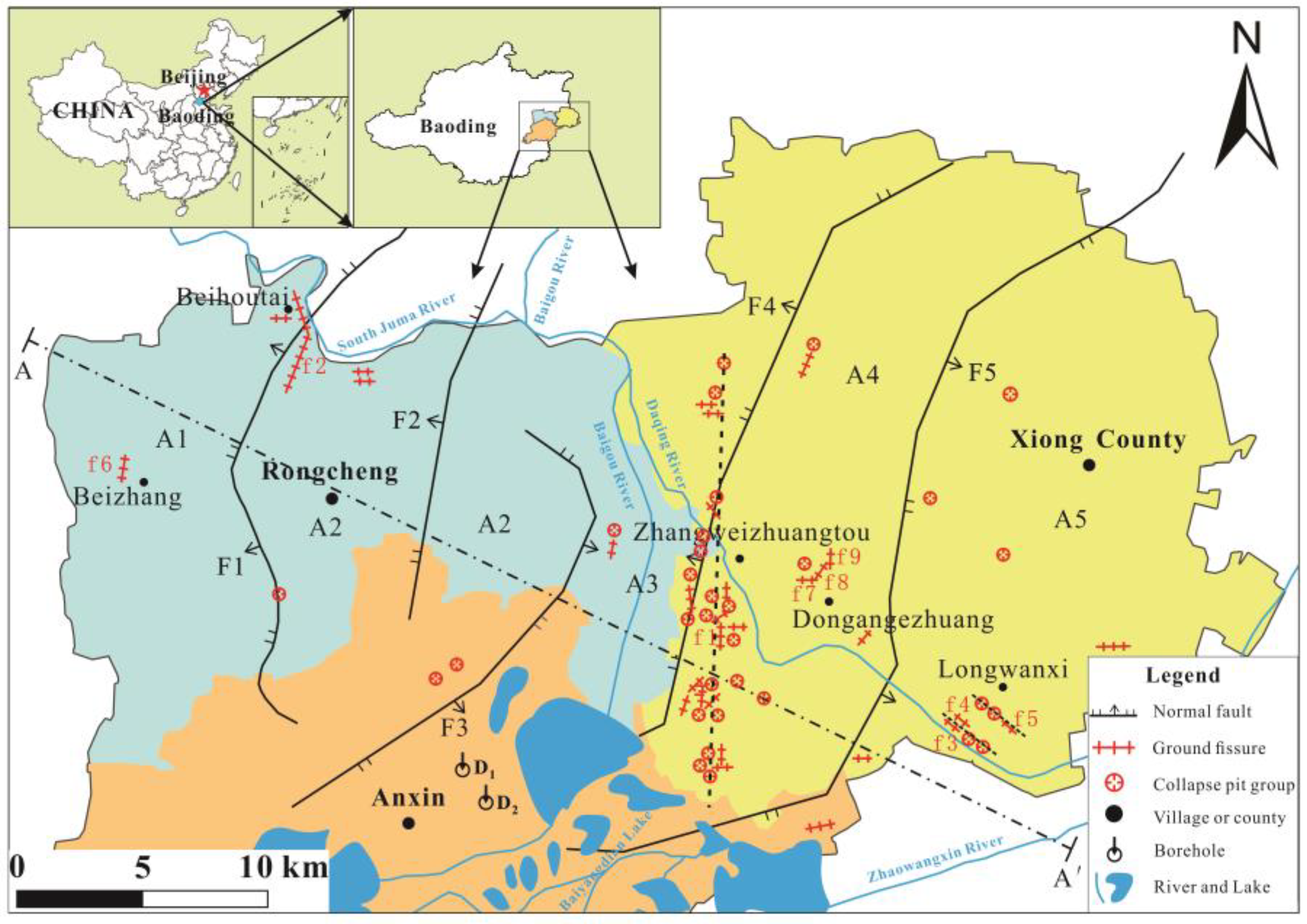
Figure 2.
Tectonic profile A-A′ in the study area [44]. Location of the profile line is shown in Figure 1.
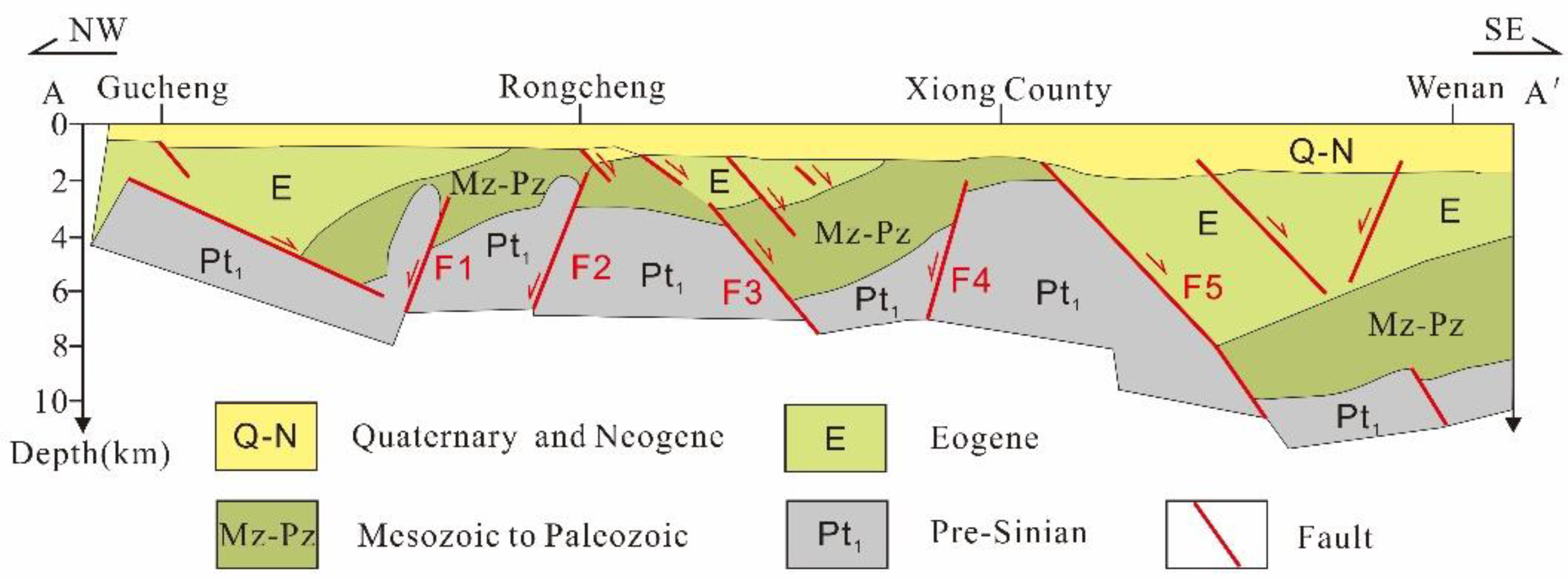
Figure 3.
Groundwater level change in the study area [45].
Figure 3.
Groundwater level change in the study area [45].
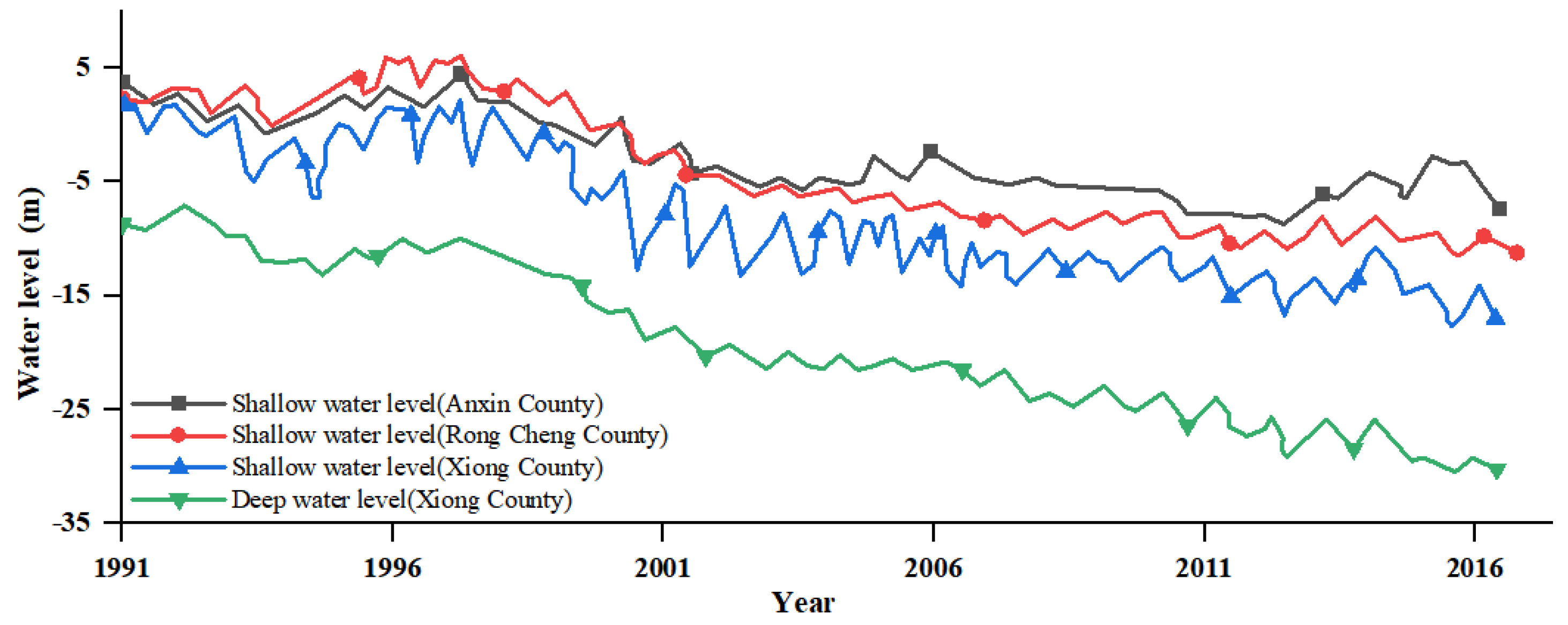
Figure 4.
Stratigraphic column profile in the study area based on drilling data [42]. The sites of drilling wells D1 and D2 are shown in Figure 1.
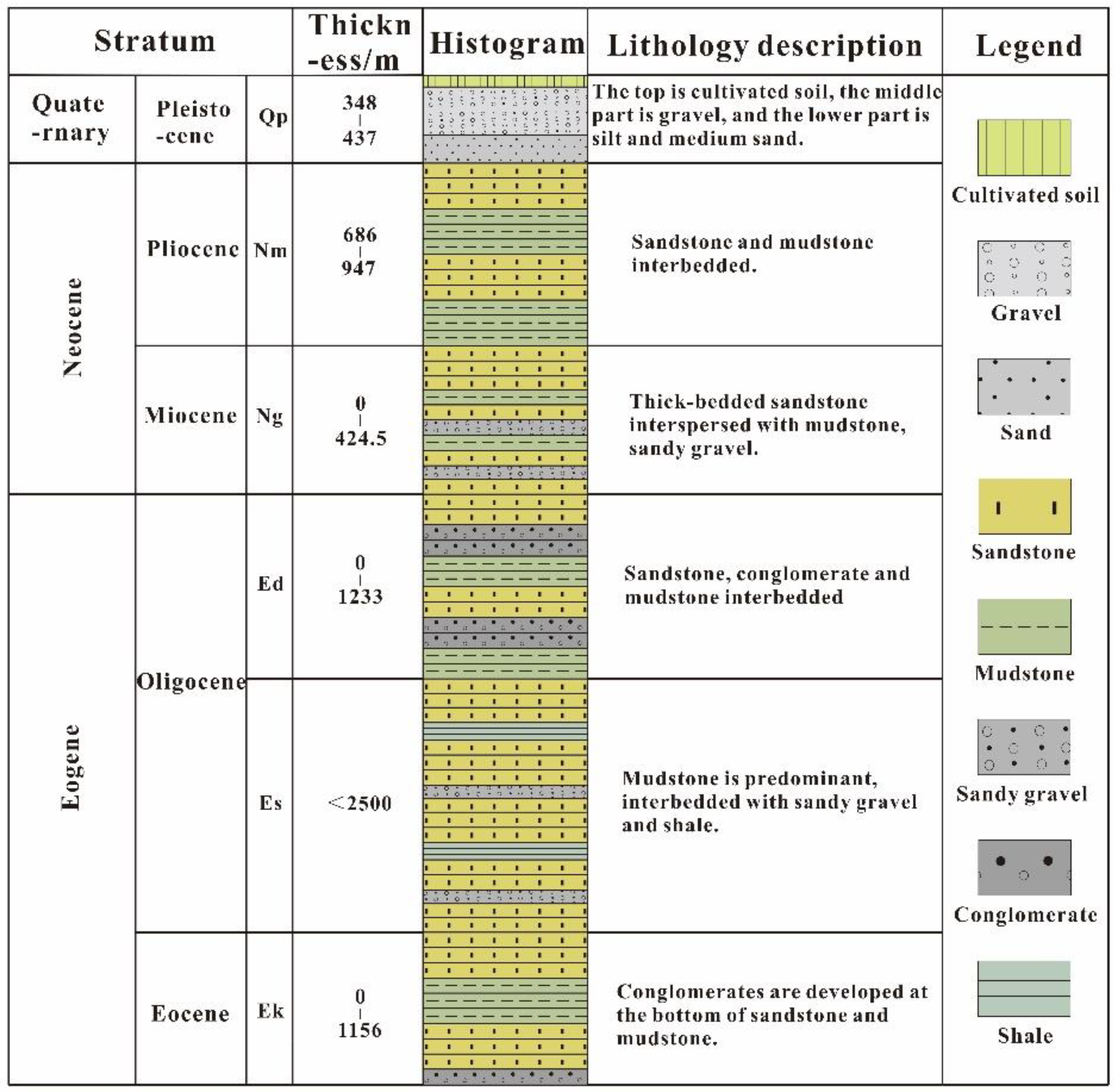
Figure 5.
Distribution of the ground fissures in Zhangweizhuangtou village and surrounding areas: (a-i) typical photos of the ground fissures.
Figure 5.
Distribution of the ground fissures in Zhangweizhuangtou village and surrounding areas: (a-i) typical photos of the ground fissures.
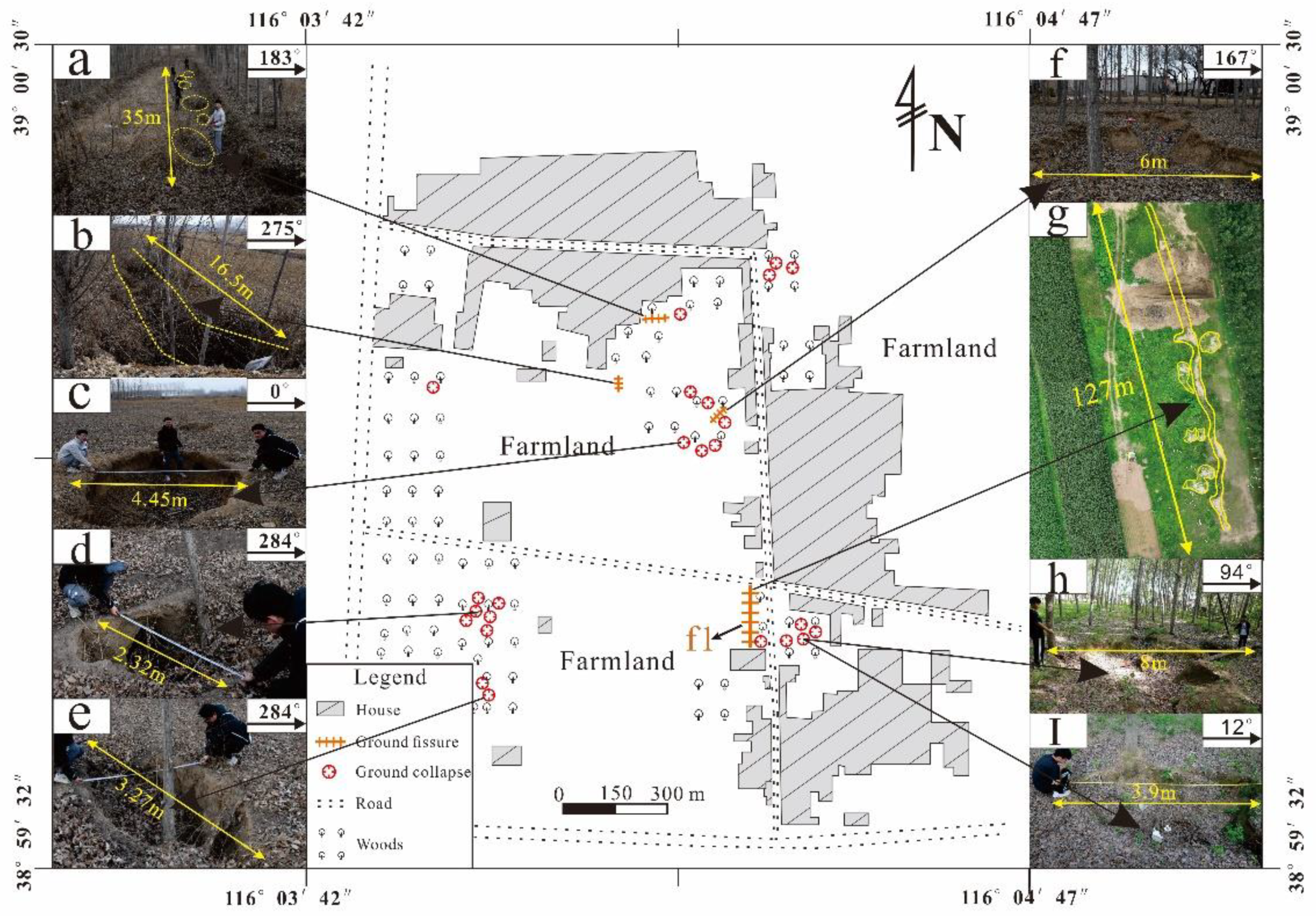
Figure 6.
Distribution of the ground fissures in Beihoutai village, Nanhoutai village, Jiaguang village and surrounding areas: (a-d, f) typical photos of the wall fissures; (e) typical photos of the house ground subsidence; (g) typical photos of the house floor fissures.
Figure 6.
Distribution of the ground fissures in Beihoutai village, Nanhoutai village, Jiaguang village and surrounding areas: (a-d, f) typical photos of the wall fissures; (e) typical photos of the house ground subsidence; (g) typical photos of the house floor fissures.
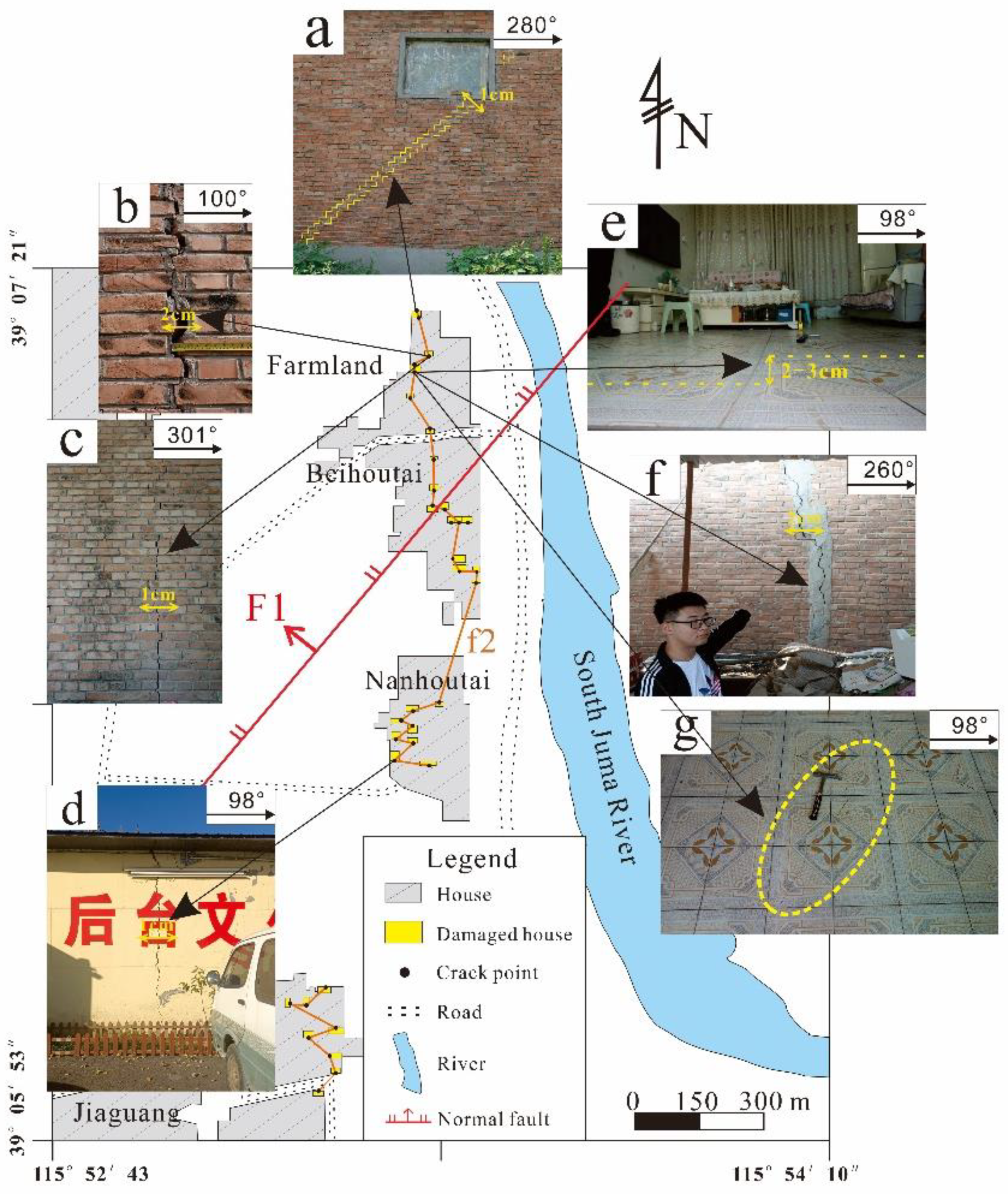
Figure 7.
Distribution of the ground fissures in Longwanxi village and surrounding areas: (a-h) typical photos of the ground fissures.
Figure 7.
Distribution of the ground fissures in Longwanxi village and surrounding areas: (a-h) typical photos of the ground fissures.
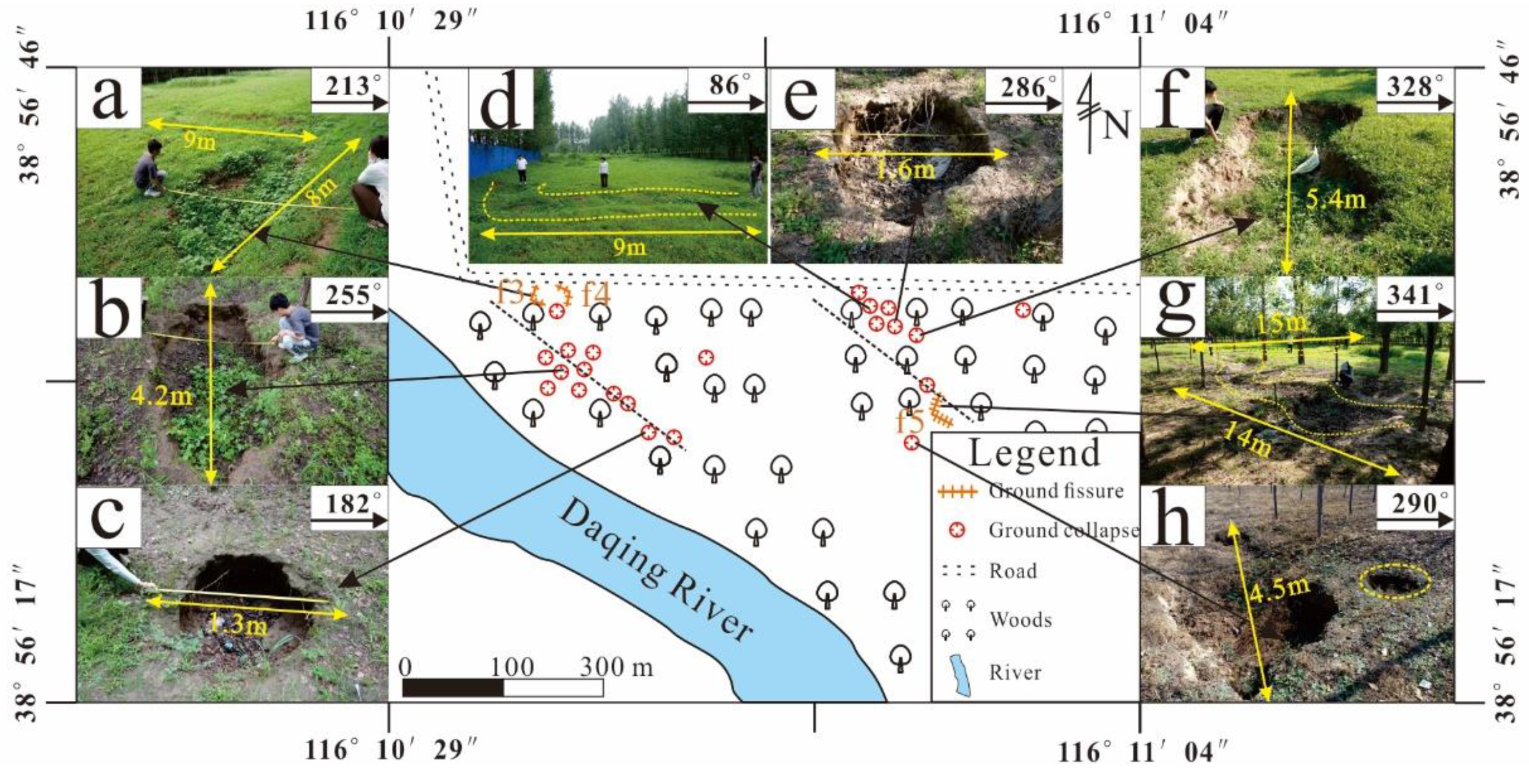
Figure 8.
Distribution of the ground fissures in Beizhang village and surrounding areas: (a-e) typical photos of the wall fissures.
Figure 8.
Distribution of the ground fissures in Beizhang village and surrounding areas: (a-e) typical photos of the wall fissures.
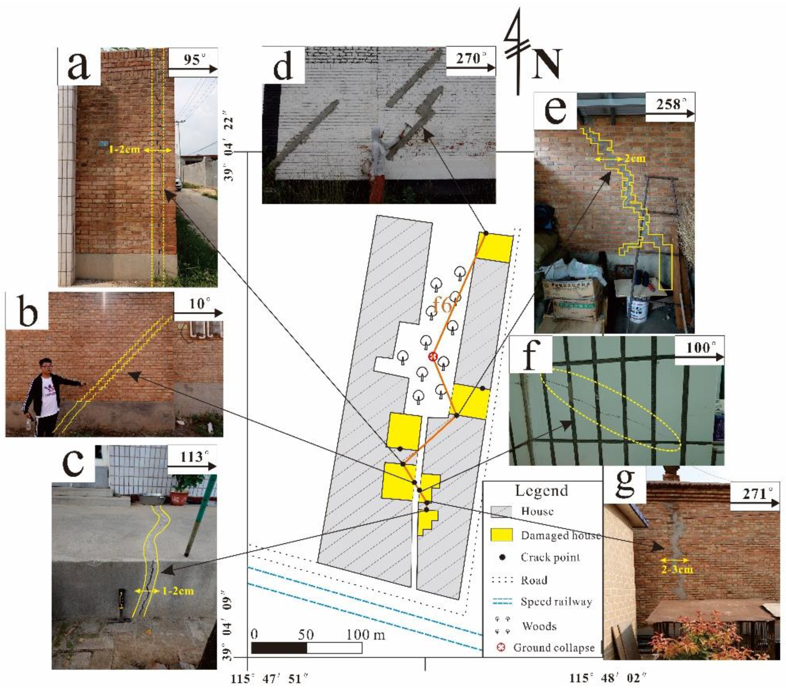
Figure 9.
Distribution of the ground fissures in Dongangezhuang village and surrounding areas: (a-e): typical photos of the ground fissures.
Figure 9.
Distribution of the ground fissures in Dongangezhuang village and surrounding areas: (a-e): typical photos of the ground fissures.
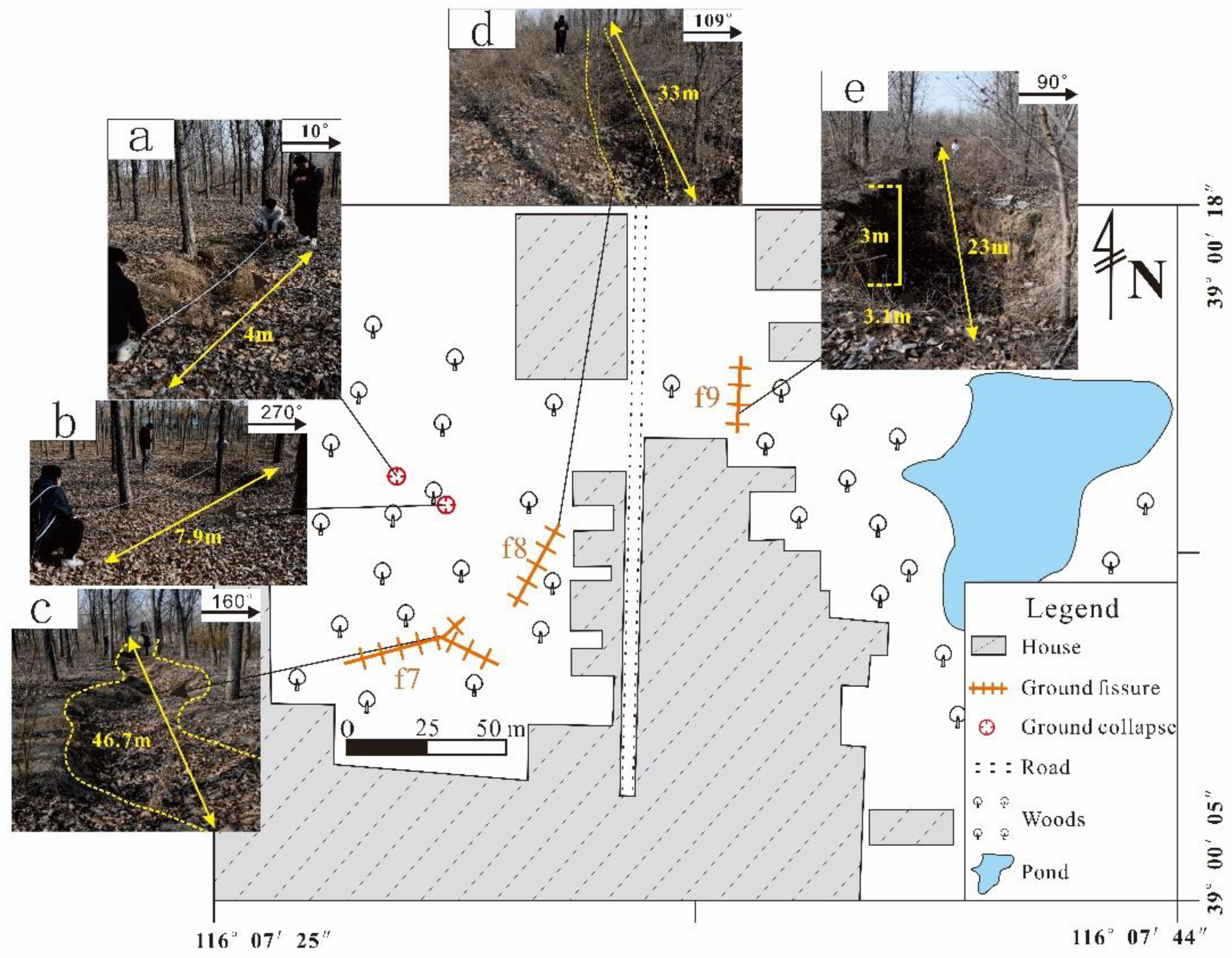
Figure 10.
Formation process of rainfall-induced ground fissures under the combined influence of fault activity and rainfall erosion: (a) fault activity initiates the formation of concealed fissures near the surface; (b) infiltration of surface water leads to erosion of the soil layer, migration of soil particles, widening of cracks, and the creation of cavities; (c) fissures propagate upward, causing surface soil to collapse into linear fissures or collapse pits.
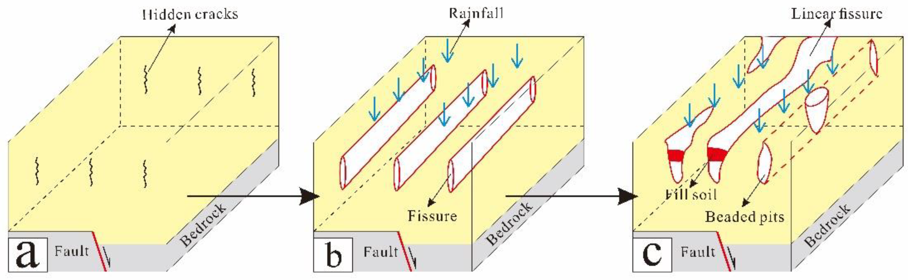
Figure 11.
Contour map of land subsidence rate in the study area (2016) [46].
Figure 11.
Contour map of land subsidence rate in the study area (2016) [46].
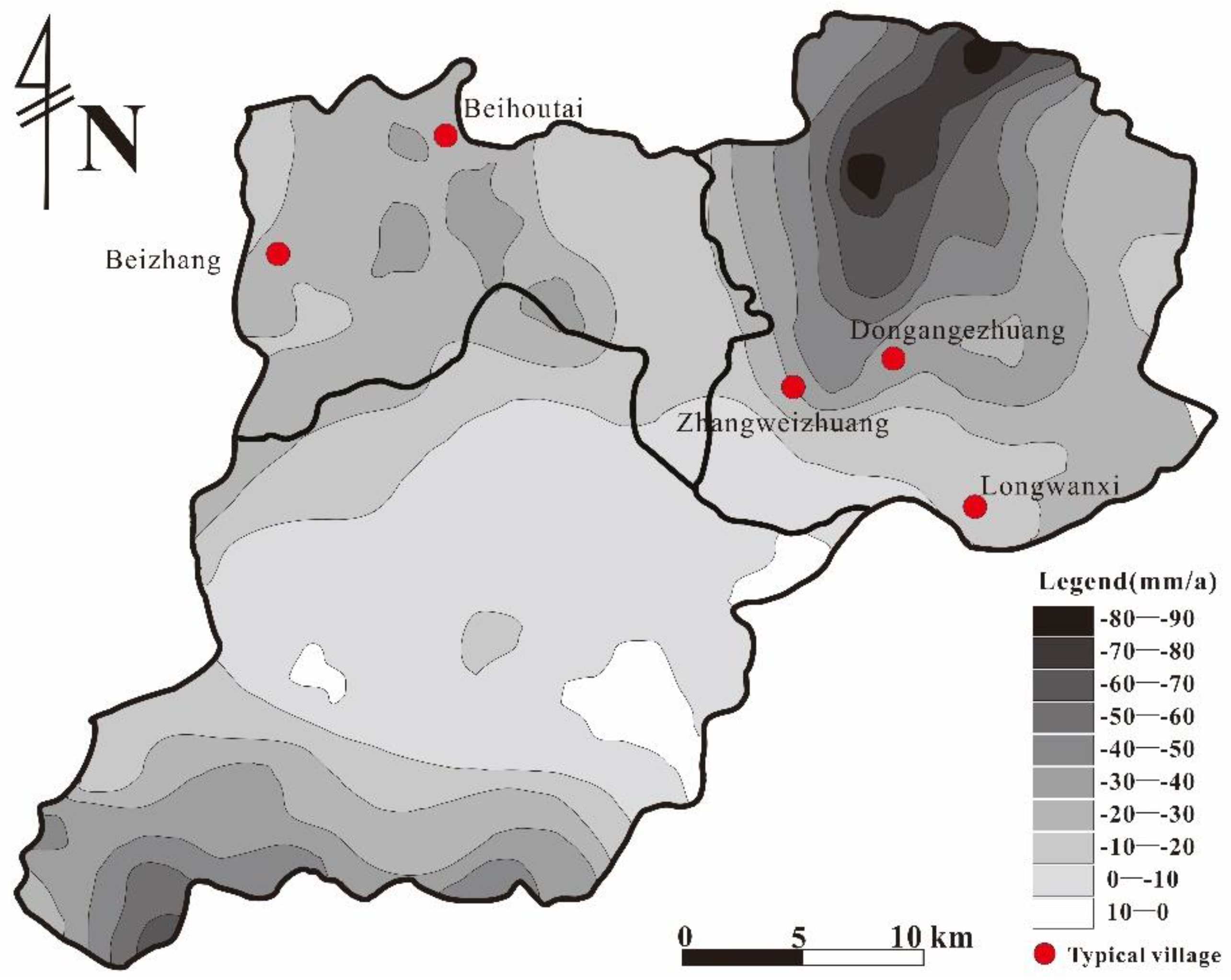
Figure 12.
Pre-Cenozoic bedrock buried depth contour map and paleochannel distribution map in the study area [47,48].
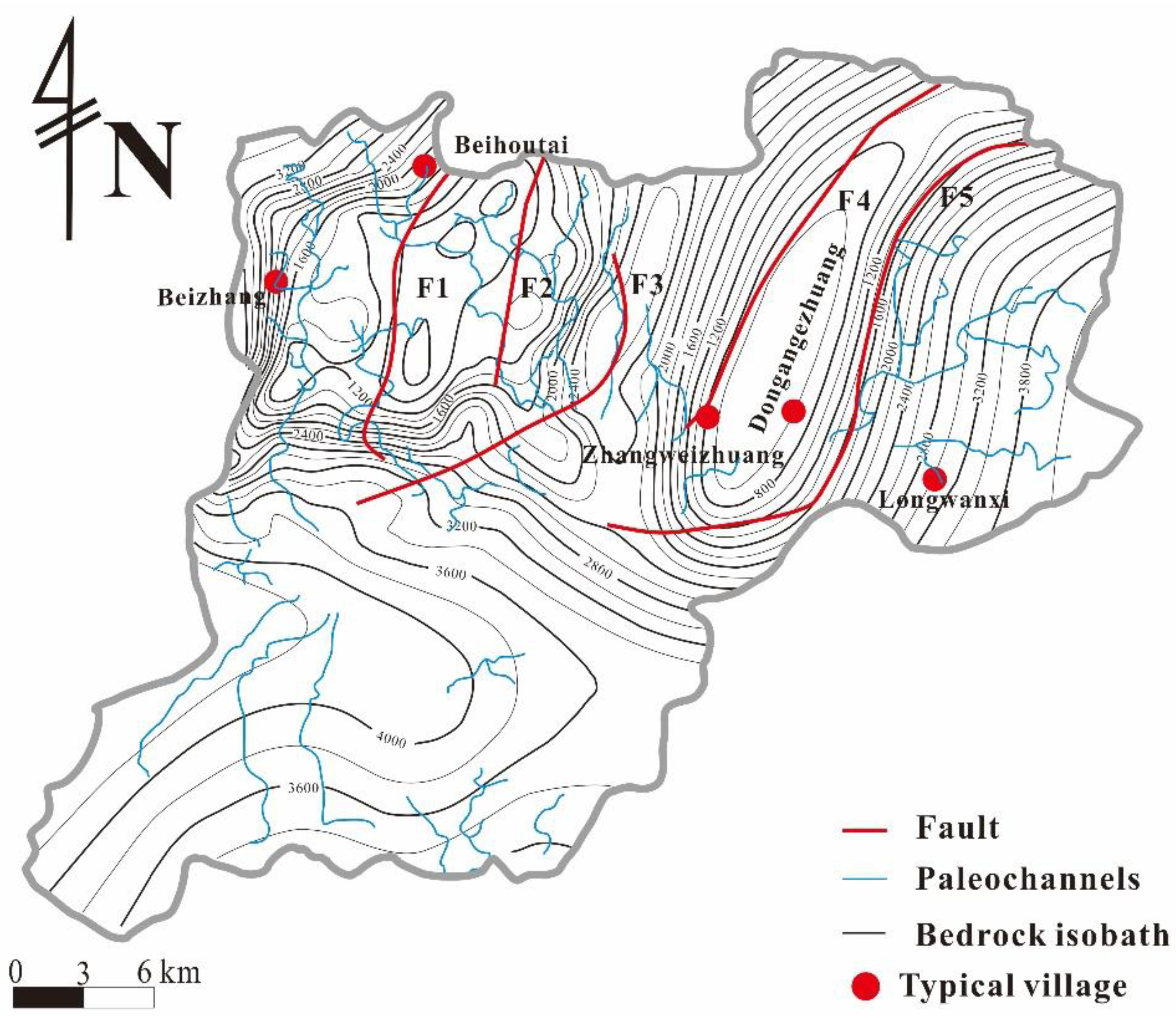
Figure 13.
Formation process of palaeochannel-type ground fissures: (a) original formation state; (b) the initial pumping resulted in uneven settlement of the strata, resulting in a tensile stress concentration area at the shoulder of the palaeochannel and forming hidden cracks; (c) further pumping causes uneven ground settlement to intensify, and hidden cracks develop and then appear on the surface; (d) stereogram of genetic mechanism of palaeochannel type ground fissures.
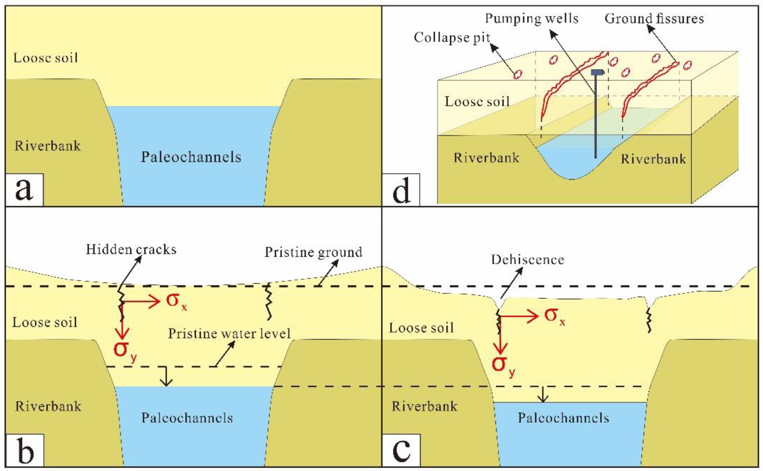
Figure 14.
Formation process of bedrock ridge-type ground fissures: (a) original formation state; (b) the initial pumping results in uneven settlement of the strata, resulting in a tensile stress concentration area at the bedrock ridge and forming hidden cracks; (c) further pumping causes uneven ground settlement to intensify, and hidden cracks develop and then appear on the surface; (d) stereogram of genetic mechanism of buried hill type ground fractures.
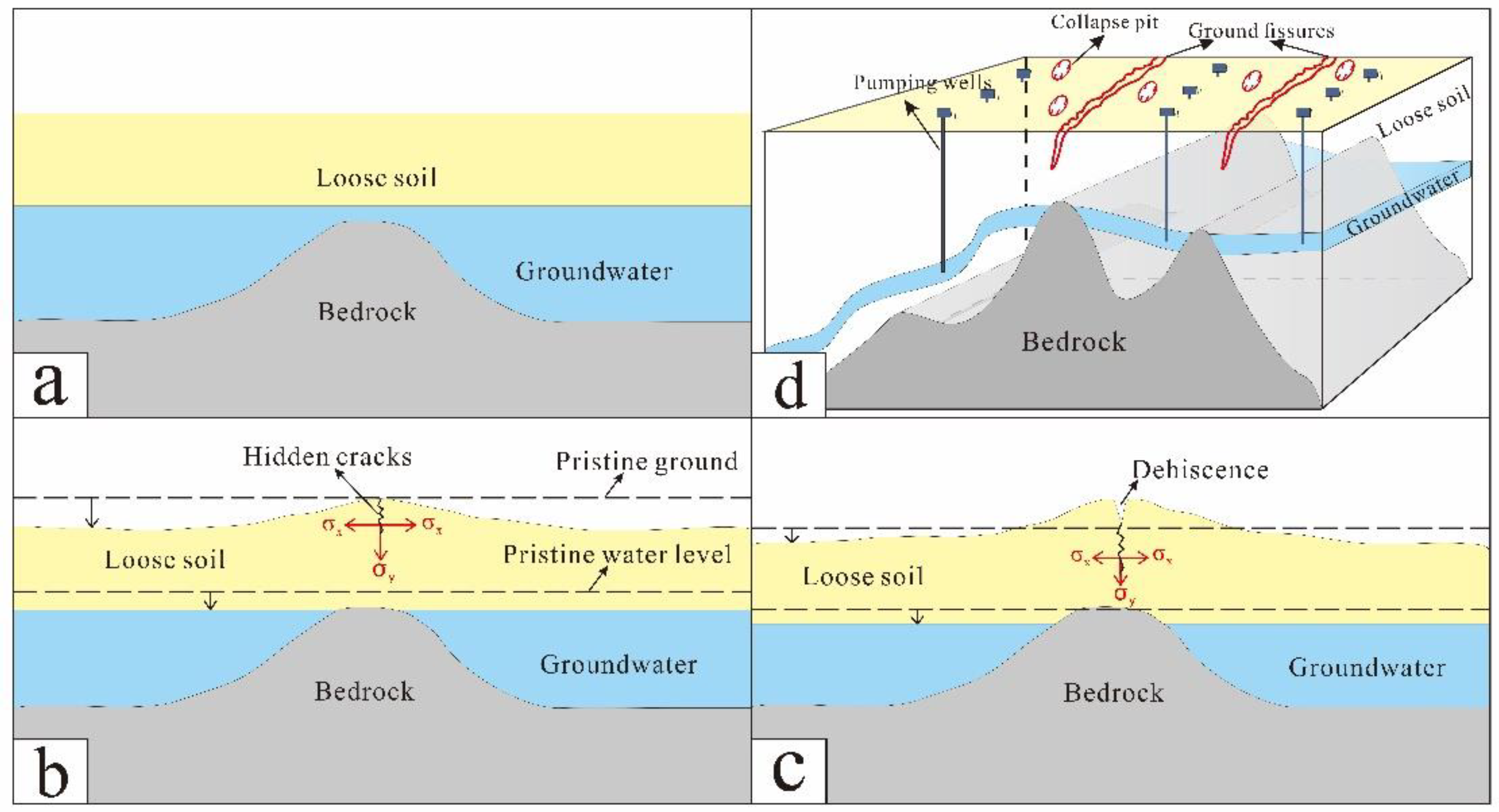
Figure 15.
Formation process of bedrock step-type ground fissures: (a) original formation state; (b) the initial pumping results in uneven formation settlement, and the tension stress concentration area is generated in the sudden change of terrain, forming hidden cracks; (c) further pumping causes uneven ground settlement to intensify, and hidden cracks develop and then appear on the surface; (d) stereographic map of the genetic mechanism of ground fissures with sudden topographic changes.


Table 1.
Statistical table of ground fissure information in the study area.
| Type | Number | Length /m |
Width /m |
Strike direction /° |
Affected object | Time |
|---|---|---|---|---|---|---|
| Small-scale linear fissures(<100m) | 33 | 0-100 | 0.2-6.6 | EW、NS | Houses, Woodlands | 1990 to date |
| Large-scale linear fissures(>100m) | 6 | 127-2200 | Houses, Woodlands | |||
| Sheet-like collapse pit clusters | 41 | 0.7-9.6 | 0.3-6.5 | Irregular | Woodlands, Farmland |
Table 2.
Details of typical fissures in the study area. Location of the ground fissures f1-f9 are shown in Figure 1.
Table 2.
Details of typical fissures in the study area. Location of the ground fissures f1-f9 are shown in Figure 1.
| No. | Village | Coordinate | Time of first occurrence | Strike direction/° | Length/m |
|---|---|---|---|---|---|
| f1 | Zhangweizhuangtou | 38°59′49.52″ | 2013 | 5 | 127 |
| 116°4′24.30″ | |||||
| f2 | Beihoutai | 39°7′10.27″ | 2013 | 170/200 | 2200 |
| 115°53′23.55″ | |||||
| f3 | Longwanxi | 38°56′34.69″ | 2021 | 100 | 24 |
| 116°10′38.38″ | |||||
| f4 | Longwanxi | 38°56′34.69″ | 2021 | 129 | 17 |
| 116°10′38.38″ | |||||
| f5 | Longwanxi | 38°56′30.74″ | 2020 | 158 | 29 |
| 116°10′57.30″ | |||||
| f6 | Beizhang | 39°4′21.52″ | 1990 | 195 | 260 |
| 115°47′58.36″ | |||||
| f7 | Dongangezhuang | 39°0′6.61″ | 2014 | 80 | 67 |
| 116°7′9.09″ | |||||
| f8 | Dongangezhuang | 39°0′7.64″ | 2014 | 19 | 33 |
| 116°7′10.67″ | |||||
| f9 | Dongangezhuang | 39°0′9.81″ | 2014 | 189 | 23 |
Disclaimer/Publisher’s Note: The statements, opinions and data contained in all publications are solely those of the individual author(s) and contributor(s) and not of MDPI and/or the editor(s). MDPI and/or the editor(s) disclaim responsibility for any injury to people or property resulting from any ideas, methods, instructions or products referred to in the content. |
© 2024 by the authors. Licensee MDPI, Basel, Switzerland. This article is an open access article distributed under the terms and conditions of the Creative Commons Attribution (CC BY) license (http://creativecommons.org/licenses/by/4.0/).
Copyright: This open access article is published under a Creative Commons CC BY 4.0 license, which permit the free download, distribution, and reuse, provided that the author and preprint are cited in any reuse.


