
Submitted:
26 May 2024
Posted:
05 June 2024
You are already at the latest version
Abstract
This research explores the application of Support Vector Machine (SVM) and Digital Surface Models (DSM) derived from Unmanned Aerial Vehicle (UAV) data for a vertical-horizontal classification of mangrove ecosystems in Tongke-tongke and Samataring Village. The study focuses on integrating high-resolution DSM subtracted from Digital Terrain Models (DTM) to classify mangrove vegetation into sixteen distinct vertical-horizontal classes based on vegetation type and elevation. The analysis revealed that older mangroves, particularly those within the 25-35 meters elevation range, dominate the landscape, accounting for 43.40% of the total classified area. This dominance suggests a mature and ecologically stable mangrove ecosystem, which is crucial for biodiversity conservation and carbon storage. The study demonstrates the effectiveness of SVM and UAV technologies in providing detailed and accurate ecological assessments of mangrove forests. The classification results contribute valuable insights into the structural diversity and health of mangrove ecosystems, facilitating targeted conservation and management strategies. Additionally, the research highlights the utility of advanced remote sensing and machine learning techniques in enhancing the precision of environmental monitoring and the assessment of carbon sequestration capabilities within mangrove ecosystems. The findings underscore the potential of UAV-based remote sensing for ecological studies, offering a replicable method for similar assessments in other regions, thereby supporting global environmental management and climate action initiatives.
Keywords:
mangrove
; vertical-horizontal classification
; UAVs
; tongke-tongke
; indonesia
1. Introduction
Mangrove ecosystems are crucial in global carbon cycling and coastal protection, particularly in archipelagic nations like Indonesia, which boasts a vast mangrove coverage across its 17,504 islands [1]. These ecosystems are pivotal for biodiversity, providing essential services such as habitat for various marine species, protection against erosion, and substantial carbon sequestration capabilities. The mangrove forests of Tongke-tongke and Samataring in Sinjai District are dominated by species like Rhizophora mucronata and Rhizophora apiculata, which are particularly noted for their high carbon storage potential above and below ground. Recent research highlights that these mangroves store an average of 125.48±93.48 Mg C/ha above ground and 60.23±44.87 Mg C/ha below ground, underscoring their significant role in mitigating climate change effects [1].
The advent of high-resolution remote sensing technologies, including unmanned aerial vehicles (UAVs), presents new methodologies for assessing these ecosystems more accurately and efficiently. Traditional field methods for measuring vegetative carbon stocks are labor-intensive and prone to errors, particularly in challenging terrains like mangrove forests [2,3]. UAVs equipped with advanced photogrammetric sensors not only offer rapid data collection but also enable precise estimations of biomass and structural attributes of forests from a vertical-horizontal perspective [4].
Despite the advantages of UAVs in environmental monitoring, the interpretation of high-resolution imagery for accurate classification and analysis of mangrove vegetation remains a significant challenge. Traditional visual interpretation methods are subjective and often result in lower accuracy and reproducibility. This limitation hampers the ability to effectively monitor and manage these critical habitats [5]. To address this, there has been a shift towards utilizing machine learning algorithms, which can handle complex image attributes and improve the accuracy and speed of data interpretation significantly.
Support Vector Machine (SVM) algorithms, in particular, have shown promise in the field of remote sensing for their robustness in handling non-linear and high-dimensional data, essential for the nuanced interpretation required in mangrove ecosystems [6]. By integrating SVM with UAV-derived data, researchers can potentially overcome the limitations of manual image classification methods, leading to more accurate, reproducible, and efficient ecological assessments [7].
The integration of UAV technology with SVM algorithms for mangrove vegetation analysis offers a compelling solution to traditional challenges. Recent studies demonstrate UAVs' capability to produce high-resolution Digital Surface Models (DSMs), Digital Terrain Models (DTMs), and orthomosaics, which are crucial for accurate height and biomass estimation [8]. This data, when processed through SVM, allows for a detailed, layered interpretation of mangrove health and structural characteristics, providing insights into both horizontal spread and vertical growth patterns.
Further, by decoupling UAV-based sensing in vertical and horizontal dimensions, researchers can achieve a more comprehensive analysis of mangrove ecosystems. This approach allows for the precise classification of different mangrove species and their health status, facilitating targeted conservation efforts [9,10]. Additionally, the use of Enhanced Navigation with Satellite Augmentation Systems further improves the positional accuracy of UAVs, essential for high-stakes ecological monitoring [11].
This methodological advancement also enables the mapping of previously inaccessible areas, showcasing UAVs' versatility and broad applicability in remote sensing applications beyond traditional forestry settings [12,13]. By leveraging these technological innovations, environmental scientists can monitor mangrove dynamics more effectively, contributing significantly to the field of ecological conservation.
Despite the advancements in UAV and SVM technologies for environmental monitoring, gaps remain in their application specifically to mangrove ecosystems in Southeast Asia. Most studies have focused on temperate or less complex forest structures, with fewer insights into intricate mangrove root systems and their unique spectral signatures [14,15]. Moreover, while UAV and SVM applications have been explored broadly, their integration for the dual analysis of mangrove canopies and root zones in vertical-horizontal planes remains underexplored. This research seeks to fill these gaps by adapting UAV-SVM methodologies specifically to the complex and varied structures of mangrove ecosystems in Indonesia.
The primary objective of this study is to develop and validate a vertical-horizontal interpretation model using UAV data and SVM algorithms to enhance the accuracy of mangrove vegetation classification in Tongke-Tongke, Indonesia. This research hypothesizes that the machine learning approach, specifically the use of SVMs, will significantly improve the classification accuracy of high-resolution UAV imagery compared to traditional manual interpretation methods. The study will focus on the high-resolution image capture and photogrammetric processing using UAVs to generate DSMs, DTMs, and orthomosaics. This novel approach is anticipated to provide a more detailed and accurate analysis of mangrove biomass and structure, thus contributing substantially to the conservation and management strategies for these critical ecosystems.
2. Materials and Methods
2.1. Study Area
The research is conducted in the mangrove areas of Tongke-Tongke and Samataring villages, located in Sinjai Regency, South Sulawesi Province, Indonesia. Positioned at approximately 120°16'30" E longitude and 5°9'0" S latitude, these areas are about 220 km away from Makassar City, the capital of South Sulawesi, and 7 km from the center of Sinjai District. This study focuses on mapping these regions to understand the ecological importance and carbon storage capacity of the mangroves. The detailed maps provided in Figure 1 help illustrate the layout and extent of the mangrove forests within the study zone, facilitating a deeper understanding of their environmental significance.
2.2. Field Data Collection
Field data collection was conducted in July and December 2022. High-resolution imagery was captured using a Phantom 4 RTK-GNSS UAV, which offers superior positioning accuracy and efficiency compared to UAVs without RTK-GNSS capabilities. The integration of RTK-GNSS technology in UAVs enhances positional accuracy and efficiency significantly, as supported by studies that demonstrate the enhanced spatial accuracy and efficiency of UAV-derived imagery [16,17]. The Phantom 4 RTK provides higher accuracy in georeferencing, elevation measurements, and topographic mapping due to its real-time kinematic (RTK) capabilities [18,19,20,21]. By integrating multi-frequency GNSS receivers, the Phantom 4 RTK achieves centimeter-level precision, enhancing the quality of photogrammetric models and topographic surveys [22,23,24]. The use of RTK-GNSS technology in UAVs like the Phantom 4 RTK enables accurate coastal mapping, structure-from-motion photogrammetry, and large-scale topographic mapping [25,26,27]. The RTK functionality significantly improves the accuracy of UAV-based measurements, making it a valuable tool for various applications requiring precise positioning and georeferencing [28,29].
2.3. Remote Sensing Data Acquisition
Remote sensing data acquisition was conducted using UAV Phantom 4 RTK-GNSS, followed by the analysis of orthomosaics to produce high-resolution images. This analysis generated images with a resolution of 7.03 cm/pixel and a Digital Surface Model (DSM) with a resolution of 14.01 cm/pixel. Orthomosaics derived from UAV data are instrumental in obtaining high-resolution multispectral images and DSMs using ArcGIS Pro. By integrating RGB and multispectral sensor data, UAV-based orthomosaics and DSMs provide detailed information useful for various applications such as land cover classification and vegetation assessment [30,31,32]. Combining orthomosaic images with DSM data enhances the accuracy of land cover classification, especially when using Convolutional Neural Networks (CNN) [31]. The exceptional spatial resolution of orthomosaics and DSMs allows for precise monitoring of vegetation changes over time [32,33]. These datasets highlight the versatility and effectiveness of orthomosaics derived from UAV data in ArcGIS Pro for geospatial analysis and remote sensing applications. For more details, refer to Figure 2.
2.4. Horizontal Interpretation
Horizontal interpretation involves analyzing high-resolution images obtained from UAVs using the Support Vector Machine (SVM) classifier in ArcGIS Pro. SVM is a supervised classification method ideally suited for segmented raster input but can also handle standard imagery. The process is structured into clear, sequential steps to ensure effective classification of various land cover types, including different mangrove stages and other land features. Steps for Horizontal Interpretation:
- Develop training samples based on a predetermined image classification plan. This includes categories such as old mangroves, middle-aged mangroves, young mangroves, non-mangrove areas, water bodies, and open land.
- Perform segmentation on the high-resolution UAV images to prepare them for detailed classification. This step breaks down the large images into manageable segments that highlight distinct features necessary for accurate classification.
- Use the SVM classifier to categorize the segmented images based on the training samples. For each class, input a set number of 1000 samples to ensure robustness in the classification results and input the segmented image into the SVM classifier to begin the classification process.
By leveraging the capabilities of SVM in ArcGIS Pro, researchers can accurately classify mangrove types and other land cover categories. The SVM method has shown high effectiveness in remote sensing applications, particularly in the classification of mangrove species and land cover mapping [34,35,36,37]. Integrating SVM with high-resolution multispectral images and Digital Surface Models (DSMs) allows for precise delineation and classification of mangrove areas. Known for minimizing errors and handling complex classification tasks, the SVM algorithm significantly enhances the accuracy of identifying different mangrove species and land cover classes. This precision is crucial for effective ecosystem monitoring and management, providing valuable insights into mangrove dynamics and supporting conservation and sustainable land use practices
2.5. Vertical Interpretation Using Height Tree
Vertical interpretation involves classifying tree heights by calibrating the Digital Surface Model (DSM) using a subtraction method where the Digital Terrain Model (DTM) is subtracted from the DSM derived from UAV imagery. The DTM, representing the bare earth without any objects, is obtained from processing using the Pixel Editor tool in ArcGIS Pro, ensuring precise terrain representation. This method effectively delineates the actual height of the terrain and the vegetation. Here are the steps for Vertical Interpretation:
- Acquire DSM and DTM from UAV-derived imagery: The DSM captures the earth's surface including all objects on it, while the DTM processed through Pixel Editor in ArcGIS Pro represents the bare earth.
- Subtract the DTM from the DSM: This step isolates the height of objects above the ground, primarily focusing on tree heights. The subtraction method aids in estimating tree height, canopy size, and biomass growth, crucial for various ecological assessments.
- Classify the resulting data into height categories: The data is categorized into five height ranges: 0 – 5m, >5 - 15m, >15 - 25m, >25 - 35m, and >35 - 40.56m. These categories facilitate understanding different forest layers or vegetation densities.
By utilizing UAV-derived DSMs and DTMs, researchers can achieve precise height estimations vital for applications such as habitat extent assessment, carbon loss estimation, and topographic change detection. Integrating the DSM-DTM subtraction method with UAV data and advanced photogrammetric techniques provides a robust framework for vertical interpretation and accurate height determination in environmental and geospatial studies, enhancing our understanding and management of ecological systems.
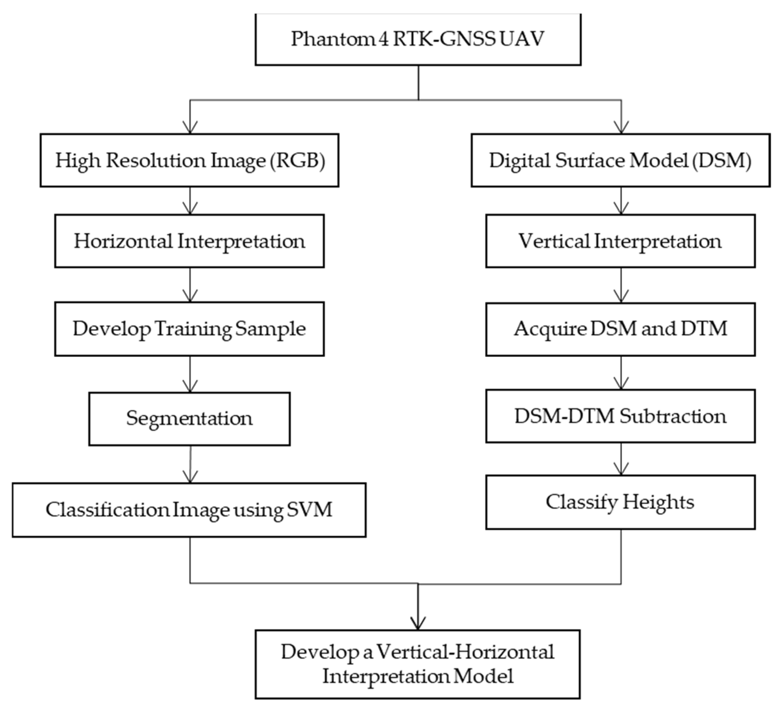
2.6. Combine Horizontal and Vertical Interpretation
Combining horizontal and vertical interpretation involves creating a new class by overlaying horizontal and vertical analysis data. This process aims to develop a vertical-horizontal interpretation model to enhance the accuracy of mangrove vegetation classification. By integrating both spatial distribution (horizontal interpretation) and height information (vertical interpretation), this approach facilitates a detailed understanding of the mangrove ecosystem. The ultimate goal is to comprehensively assess the distribution and structure of the mangrove vegetation, as well as the carbon reserves stored in the ecosystem based on the types and heights of the trees. This combined method provides a more accurate and holistic view of the mangrove habitats, supporting effective management and conservation practices.
Figure 3.
Research framework for Develop a Vertical-Horizontal Interpretation Model.
3. Results and Discussion
3.1. Horizontal Interpretation Using Support Vector Machine
The application of Support Vector Machine (SVM) for the classification of mangrove vegetation using high-resolution UAV imagery has produced detailed insights into the distribution of mangrove stages in the Tongke-tongke area, as depicted in Figure 4 and quantified in Table 1. The classified areas are predominantly occupied by old mangrove cover, which spans 35.432 hectares, representing 62.94% of the total classified area. This substantial presence of mature mangroves indicates a well-established and potentially stable mangrove ecosystem. Additionally, the presence of younger mangrove stages, covering 1.381 hectares (2.45%) for young mangrove and 15.538 hectares (27.60%) for middle-aged mangrove, suggests ongoing natural regeneration and successful reforestation efforts within the region.
The use of SVM in vegetation classification is well-documented, with its ability to handle complex, segmented raster inputs as well as standard imagery proving effective in various environmental applications. The classification of different growth stages of mangroves and the distinction between mangrove and non-mangrove areas highlight the method's robustness and sensitivity to spectral variations in the imagery [35,38]. Studies like those by Cao et al. in 2018 and Jiang et al. in 2021 have successfully employed SVM for classifying mangrove species using UAV hyperspectral imagery, demonstrating the algorithm's precision in distinguishing between species based on subtle spectral differences [36,39]. The comparative effectiveness of SVM against other algorithms, such as Random Forest, further showcases its superior performance in reducing classification errors and enhancing mapping accuracy [40,41].
The dominance of old mangrove in the classified areas underlines the ecological stability and maturity of the mangrove forests in Tongke-tongke, which are crucial for carbon sequestration and coastal protection. The findings from this study using SVM classification provide a reliable method for ongoing monitoring and management of mangrove ecosystems. The ability of SVM to accurately classify mangrove stages supports targeted conservation strategies, allowing for focused restoration in areas showing less regenerative success. Furthermore, the integration of SVM with UAV technology not only enhances the accuracy of ecological assessments but also offers a scalable solution for environmental monitoring, which can be replicated in other mangrove-rich regions globally. This contributes significantly to our understanding and management of these critical ecosystems, with potential applications extending to biodiversity conservation, climate change mitigation, and habitat restoration.
3.2. Vertical Interpretation Using Height Tree (DSM as Real High)
Digital Surface Models (DSMs) derived from UAV photogrammetric data were converted into Digital Elevation Models (DEMs) with elevation ranges from 39.4779 m to 79.5572 m, as shown in Figure 5a. The real terrain height was calculated by subtracting the Digital Terrain Model (DTM) from the DSM, depicted in Figure 5b, which isolates the actual heights of above-ground objects such as vegetation and structures. The adjusted DSM provides an accurate representation of tree and vegetation heights without the influence of ground elevation.
The DSM, once adjusted for real heights, was classified into five vertical categories based on tree height: 0 – 5 m, >5- 15 m, >15 – 25 m, >25 – 35 m, and >35 – 40.56 m, as depicted in Figure 6 and summarized in Table 2. The predominance of the >25-35 m class, covering 38.284 hectares or 68.00% of the total area, suggests a region with relatively tall trees, indicative of a mature or fertile mangrove ecosystem. This classification shows significant vertical stratification, with 13.61% of the area hosting very tall trees (>35 m). Areas with lower tree heights (0-5 m), covering 4.87% of the total area, likely represent newly developing regions or zones with lower vegetative growth.
The detailed classification of tree height using DSM and DTM techniques underscores the capability of UAV technology to provide essential data for environmental monitoring and ecological management. The dominance of tall trees (>25 m) in the studied area can be associated with healthy forest dynamics and suggests robust ecological functioning, important for biodiversity, carbon sequestration, and habitat stability. The findings from this UAV-based study offer practical insights into the health and structure of the mangrove forests, which are crucial for planning conservation and sustainable management practices.
The ability to map vertical structure accurately enables better assessment of forest biomass and carbon stocks, supporting efforts to mitigate climate change through carbon capture. The utilization of UAV technology, as shown in this study, is particularly effective in rugged terrains and mixed species stands, offering a cost-effective and rapid assessment tool compared to traditional ground-based or manned aerial surveys. This approach not only aids in the ongoing conservation efforts but also provides a replicable model for similar ecological assessments globally, enhancing our capacity to monitor and manage critical natural resources effectively.
3.3. Combine Interpretation Using SVM and Height Tree (DSM – DTM)
Utilizing Support Vector Machine (SVM) and Tree Height data (derived from DSM minus DTM) for vertical-horizontal interpretation, this analysis generated sixteen classes based on combinations of vegetation type and elevation. This classification, depicted in Figure 7 and summarized in Table 3, provides a comprehensive snapshot of the distribution and structure of mangrove vegetation across various elevation ranges in the regions of Tongke-tongke and Samataring.
The class of old mangroves with elevations between 25 - 35 meters is the most dominant, covering an area of 24.436 hectares, or 43.40% of the total classified area. This indicates that older mangroves within this height range are the most extensive component of the ecosystem, as observed in Figure 7 and Table 3. Studies like those by Zhu et al. in 2022 and Beselly et al. in 2021 emphasize the importance of integrating mangrove age classification and stand height information for understanding mangrove ecosystems [42,43]. These taller and older mangroves likely contribute significantly to carbon storage, which is supported by findings from Sugiatmo et al. in 2023 and Aye et al. in 2022 that highlight the relationship between stand height, mangrove biomass, and their carbon sequestration capacities [44,45].
The detailed vertical and horizontal classification of mangroves facilitates a deeper understanding of the ecological dynamics and health of mangrove forests. The predominance of older and taller mangrove stands in significant areas suggests a mature ecosystem, which is crucial for biodiversity, carbon storage, and coastal protection. These insights are invaluable for mangrove conservation and management, enabling targeted actions to preserve and enhance these critical coastal ecosystems.
Moreover, the integration of UAV technology and sophisticated analysis techniques like SVM provides a powerful toolset for accurately mapping and assessing mangrove ecosystems. This approach not only supports current conservation efforts but also enhances our ability to predict and mitigate the impacts of environmental changes on mangrove forests. Accurate data on mangrove structure and carbon stocks, as provided by this study, are essential for effective environmental management and for meeting global climate objectives by quantifying and enhancing the carbon sequestration potential of these vital ecosystems.
4. Conclusions
This study utilized Support Vector Machine (SVM) and Digital Surface Model (DSM) subtraction from Digital Terrain Models (DTM) to perform a detailed vertical-horizontal classification of mangrove ecosystems in Tongke-tongke and Samataring Village. The comprehensive classification generated sixteen distinct classes of mangrove vegetation, which varied by type and elevation, revealing significant insights into the ecological structure and health of these areas.
The findings highlighted the dominance of older mangrove classes at elevations between 25 to 35 meters, constituting 43.40% of the total classified area. This predominance indicates a mature and stable mangrove ecosystem, which is vital for biodiversity conservation, carbon storage, and protection against coastal erosion and storm surges. The vertical and horizontal classification provided by this study enables a nuanced understanding of the mangrove ecosystem, aiding in effective management and conservation strategies. The application of UAV technology and SVM in this research has proven to be highly effective, offering a cost-effective and precise method for ecological monitoring and management. The ability to accurately measure and analyze mangrove height and density supports ongoing efforts to assess and enhance carbon sequestration capabilities, contributing to broader environmental management and climate mitigation goals. This study underscores the importance of integrating advanced remote sensing technologies and machine learning techniques to enhance the accuracy and efficiency of environmental conservation efforts globally.
Author Contributions
Conceptualization, A.S. and S.A.; methodology, S.S., A.S. and S.A.; software, S.S. and A.S.; validation, S.S. and A.S.; formal analysis, A.S..; data curation, A.S. and S.A.; writing—original draft preparation, S.S., A.S., S.A., M.N., A.A. and S.R.; writing—review and editing, S.S., A.S., M.N. and S.R, All authors have read and agreed to the published version of the manuscript.
Funding
This research was funded by the Ministry of Research, Technology and Higher Education Indonesia 2022.
Data Availability Statement
The acoustic data and lighting location data are available on request.
Acknowledgments
The authors would like to express their gratitude to the editor and reviewers for their insightful comments and suggestions. We also extend our thanks to Esri Indonesia for providing an ArcGIS license under the Memorandum of Understanding (MoU) with Hasanuddin University. Additionally, we appreciate the support from the Ministry of Research, Technology, and Higher Education of Indonesia for funding this research.
Conflicts of Interest
The authors declare no conflict of interest.
References
- Malik, A.; Jalil, A.; Arifuddin, A.; Syahmuddin, A. Biomass Carbon Stocks in the Mangrove Rehabilitated Area of Sinjai District, South Sulawesi, Indonesia. Geogr. Environ. Sustain. 2020, 13, 32–38. [Google Scholar] [CrossRef]
- De Petris, S.; Berretti, R.; Sarvia, F.; Borgogno Mondino, E. When a Definition Makes the Difference: Operative Issues about Tree Height Measures from RPAS-Derived CHMs. iForest-Biogeosciences For. 2020, 13, 404. [Google Scholar] [CrossRef]
- Jurjević, L.; Liang, X.; Gašparović, M.; Balenović, I. Is Field-Measured Tree Height as Reliable as Believed–Part II, A Comparison Study of Tree Height Estimates from Conventional Field Measurement and Low-Cost Close-Range Remote Sensing in a Deciduous Forest. ISPRS J. Photogramm. Remote Sens. 2020, 169, 227–241. [Google Scholar] [CrossRef]
- Ganz, S.; Käber, Y.; Adler, P. Measuring Tree Height with Remote Sensing—A Comparison of Photogrammetric and LiDAR Data with Different Field Measurements. Forests 2019, 10, 694. [Google Scholar] [CrossRef]
- Camarretta, N.; Harrison, P.A.; Bailey, T.; Potts, B.; Lucieer, A.; Davidson, N.; Hunt, M. Monitoring Forest Structure to Guide Adaptive Management of Forest Restoration: A Review of Remote Sensing Approaches. New For. 2020, 51, 573–596. [Google Scholar] [CrossRef]
- Zhou, P.C.; Cheng, G.; Yao, X.W.; Han, J.W. Machine Learning Paradigms in High-Resolution Remote Sensing Image Interpretation. Natl. Remote Sens. Bull. 2021, 25, 182–197. [Google Scholar] [CrossRef]
- Sun, G.; Rong, X.; Zhang, A.; Huang, H.; Rong, J.; Zhang, X. Multi-Scale Mahalanobis Kernel-Based Support Vector Machine for Classification of High-Resolution Remote Sensing Images. Cognit. Comput. 2021, 13, 787–794. [Google Scholar] [CrossRef]
- Mielcarek, M.; Kamińska, A.; Stereńczak, K. Digital Aerial Photogrammetry (DAP) and Airborne Laser Scanning (ALS) as Sources of Information about Tree Height: Comparisons of the Accuracy of Remote Sensing Methods for Tree Height Estimation. Remote Sens. 2020, 12, 1808. [Google Scholar] [CrossRef]
- Amroune, M.; El-Keyi, A.; Lagum, F.; Yanıkömeroğlu, H. 3-D Placement of an Unmanned Aerial Vehicle Base Station (UAV-BS) for Energy-Efficient Maximal Coverage. Ieee Wirel. Commun. Lett. 2017. [Google Scholar] [CrossRef]
- Wu, Q.; Xu, J.; Zhang, R. Capacity Characterization of UAV-Enabled Two-User Broadcast Channel. Ieee J. Sel. Areas Commun. 2018. [Google Scholar] [CrossRef]
- Krasuski, K.; Wierzbicki, D.; Bakuła, M. Improvement of UAV Positioning Performance Based on EGNOS+SDCM Solution. Remote Sens. 2021. [Google Scholar] [CrossRef]
- Ćwiąkała, P.; Gruszczyński, W.; Stoch, T.; Puniach, E.; Mrocheń, D.; Matwij, W.; Matwij, K.; Nędzka, M.; Sopata, P.; Wójcik, A. UAV Applications for Determination of Land Deformations Caused by Underground Mining. Remote Sens. 2020. [Google Scholar] [CrossRef]
- Tomaštík, J.; Mokroš, M.; Surový, P.; Grznárová, A.; Merganič, J. UAV RTK/PPK Method—An Optimal Solution for Mapping Inaccessible Forested Areas? Remote Sens. 2019. [Google Scholar] [CrossRef]
- Zhang, H.; Yang, J.; Li, S.Q.; Jin, B.; Han, W.T.; Yang, X.; Gai, L.; Ritsema, C.J.; Geissen, V. Quality of Terrestrial Data Derived From UAV Photogrammetry: A Case Study of Hetao Irrigation District in Northern China. Int. J. Agric. Biol. Eng. 2018. [Google Scholar] [CrossRef]
- Jo, Y.H.; Kim, J.Y. Three-Dimensional Digital Documentation of Heritage Sites Using Terrestrial Laser Scanning And Unmanned Aerial Vehicle Photogrammetry. Int. Arch. Photogramm. Remote Sens. Spat. Inf. Sci. 2017. [Google Scholar] [CrossRef]
- Azim, S.; Rasmussen, J.; Nielsen, J.; Gislum, R.; Laursen, M.S.; Christensen, S. Manual Geo-Rectification to Improve the Spatial Accuracy of Ortho-Mosaics Based on Images from Consumer-Grade Unmanned Aerial Vehicles (UAVs). Precis. Agric. 2019, 20, 1199–1210. [Google Scholar] [CrossRef]
- Stott, E.; Williams, R.D.; Hoey, T.B. Ground Control Point Distribution for Accurate Kilometre-Scale Topographic Mapping Using an RTK-GNSS Unmanned Aerial Vehicle and SfM Photogrammetry. Drones 2020, 4, 55. [Google Scholar] [CrossRef]
- Sanz-Ablanedo, E.; Chandler, J.H.; Rodríguez-Pérez, J.R.; Ordóñez, C. Accuracy of Unmanned Aerial Vehicle (UAV) and SfM Photogrammetry Survey as a Function of the Number and Location of Ground Control Points Used. Remote Sens. 2018. [Google Scholar] [CrossRef]
- Štroner, M.; Urban, R.; Reindl, T.; Seidl, J.; Brouček, J. Evaluation of the Georeferencing Accuracy of a Photogrammetric Model Using a Quadrocopter With Onboard GNSS RTK. Sensors 2020. [Google Scholar] [CrossRef]
- Taddia, Y.; González-García, L.; Zambello, E.; Pellegrinelli, A. Quality Assessment of Photogrammetric Models for Façade and Building Reconstruction Using DJI Phantom 4 RTK. Remote Sens. 2020. [Google Scholar] [CrossRef]
- Peppa, M. V; Hall, J.R.; Goodyear, J.; Mills, J.P. Photogrammetric Assessment and Comparison of Dji Phantom 4 Pro and Phantom 4 RTK Small Unmanned Aircraft Systems. Int. Arch. Photogramm. Remote Sens. Spat. Inf. Sci. 2019. [Google Scholar] [CrossRef]
- Canh, L. V; Cuong, C.X.; Long, N.Q.; Ha, L.T.T.; Anh, T.T.; Bui, X.-N. Experimental Investigation on the Performance of DJI Phantom 4 RTK in the PPK Mode for 3D Mapping Open-Pit Mines. Inżynieria Miner. 2020. [Google Scholar] [CrossRef]
- Forlani, G.; Diotri, F.; Cella, U.M. d.; Roncella, R. Uav Block Georeferencing and Control by On-Board GNSS Data. Int. Arch. Photogramm. Remote Sens. Spat. Inf. Sci. 2020. [Google Scholar] [CrossRef]
- Štroner, M.; Urban, R.; Seidl, J.; Reindl, T.; Brouček, J. Photogrammetry Using UAV-Mounted GNSS RTK: Georeferencing Strategies Without GCPs. Remote Sens. 2021. [Google Scholar] [CrossRef]
- Losè, L.T.; Chiabrando, F.; Tonolo, F.G. Boosting the Timeliness of UAV Large Scale Mapping. Direct Georeferencing Approaches: Operational Strategies and Best Practices. Isprs Int. J. Geo-Information, 2020. [Google Scholar] [CrossRef]
- Belloni, V.; Fugazza, D.; Rita, M.D. Uav-Based Glacier Monitoring: GNSS Kinematic Track Post-Processing and Direct Georeferencing for Accurate Reconstructions in Challenging Environments. Int. Arch. Photogramm. Remote Sens. Spat. Inf. Sci. 2022. [Google Scholar] [CrossRef]
- Ekaso, D.; Nex, F.; Kerle, N. Accuracy Assessment of Real-Time Kinematics (RTK) Measurements on Unmanned Aerial Vehicles (UAV) for Direct Geo-Referencing. Geo-Spatial Inf. Sci. 2020. [Google Scholar] [CrossRef]
- Taddia, Y.; Stecchi, F.; Pellegrinelli, A. Using Dji Phantom 4 RTK Drone for Topographic Mapping of Coastal Areas. Int. Arch. Photogramm. Remote Sens. Spat. Inf. Sci. 2019. [Google Scholar] [CrossRef]
- He, Z.; Aldana-Jague, E.; Clapuyt, F.; Wilken, F.; Vanacker, V.; Oost, K. V Evaluating the Potential of Post-Processing Kinematic (PPK) Georeferencing for UAV-Based Structure- From-Motion (SfM) Photogrammetry and Surface Change Detection. Earth Surf. Dyn. 2019. [Google Scholar] [CrossRef]
- Marzialetti, F.; Frate, L.; Simone, W.D.; Frattaroli, A.R.; Acosta, A.T.R.; Carranza, M.L. Unmanned Aerial Vehicle (UAV)-Based Mapping of Acacia Saligna Invasion in the Mediterranean Coast. Remote Sens. 2021. [Google Scholar] [CrossRef]
- Al-Najjar, H.A.H.; Kalantar, B.; Pradhan, B.; Saeidi, V.; Halin, A.A.; Ueda, N.; Mansor, S. Land Cover Classification From Fused DSM and UAV Images Using Convolutional Neural Networks. Remote Sens. 2019. [Google Scholar] [CrossRef]
- Fabbri, S.; Grottoli, E.; Armaroli, C.; Ciavola, P. Using High-Spatial Resolution UAV-Derived Data to Evaluate Vegetation and Geomorphological Changes on a Dune Field Involved in a Restoration Endeavour. Remote Sens. 2021. [Google Scholar] [CrossRef]
- Lendzioch, T.; Langhammer, J.; Jenicek, M. Estimating Snow Depth and Leaf Area Index Based on UAV Digital Photogrammetry. Sensors 2019. [Google Scholar] [CrossRef]
- Cao, Y.; Ding, Z.; Xue, F.; Rong, X. An Improved Twin Support Vector Machine Based on Multi-Objective Cuckoo Search for Software Defect Prediction. Int. J. Bio-Inspired Comput. 2018, 11, 282–291. [Google Scholar] [CrossRef]
- Heenkenda, M.K.; Joyce, K.E.; Maier, S.W.; Bartolo, R. Mangrove Species Identification: Comparing WorldView-2 with Aerial Photographs. Remote Sens. 2014, 6, 6064–6088. [Google Scholar] [CrossRef]
- Jiang, Y.; Zhang, L.; Yan, M.; Qi, J.; Fu, T.; Fan, S.; Chen, B. High-Resolution Mangrove Forests Classification with Machine Learning Using Worldview and UAV Hyperspectral Data. Remote Sens. 2021, 13, 1529. [Google Scholar] [CrossRef]
- Wang, D.; Wan, B.; Qiu, P.; Su, Y.; Guo, Q.; Wu, X. Artificial Mangrove Species Mapping Using Pléiades-1: An Evaluation of Pixel-Based and Object-Based Classifications With Selected Machine Learning Algorithms. Remote Sens. 2018. [Google Scholar] [CrossRef]
- Faghihi, R.; Faridafshin, M.; Movafeghi, A. Patch-Based Weld Defect Segmentation and Classification Using Anisotropic Diffusion Image Enhancement Combined with Support-Vector Machine. Russ. J. Nondestruct. Test. 2021, 57, 61–71. [Google Scholar] [CrossRef]
- Cao, J.; Leng, W.; Liu, K.; Liu, L.; He, Z.; Zhu, Y. Object-Based Mangrove Species Classification Using Unmanned Aerial Vehicle Hyperspectral Images and Digital Surface Models. Remote Sens. 2018. [Google Scholar] [CrossRef]
- Quang, N.H.; Quinn, C.H.; Stringer, L.C.; Carrie, R.; Hackney, C.R.; Van Hue, L.T.; Van Tan, D.; Nga, P.T.T. Multi-Decadal Changes in Mangrove Extent, Age and Species in the Red River Estuaries of Viet Nam. Remote Sens. 2020, 12, 2289. [Google Scholar] [CrossRef]
- Soffianian, A.; Toosi, N.B.; Asgarian, A.; Regnauld, H.; Fakheran, S.; Waser, L.T. Evaluating Resampled and Fused Sentinel-2 Data and Machine-Learning Algorithms for Mangrove Mapping in the Northern Coast of Qeshm Island, Iran. Nat. Conserv. 2023. [Google Scholar] [CrossRef]
- Zhu, Z.; Huang, M.; Zhou, Z.; Chen, G.; Zhu, X. Stronger Conservation Promotes Mangrove Biomass Accumulation: Insights From Spatially Explicit Assessments Using <scp>UAV</Scp> and Landsat Data. Remote Sens. Ecol. Conserv. 2022. [Google Scholar] [CrossRef]
- Beselly, S.M.; Wegen, M. v. d.; Grueters, U.; Reyns, J.; Dijkstra, J.; Roelvink, D. Eleven Years of Mangrove–Mudflat Dynamics on the Mud Volcano-Induced Prograding Delta in East Java, Indonesia: Integrating UAV and Satellite Imagery. Remote Sens. 2021. [Google Scholar] [CrossRef]
- Sugiatmo, S.; Poedjirahajoe, E.; Pudyatmoko, S.; Purwanto, R.H. Carbon Stock at Several Types of Mangrove Ecosystems in Bregasmalang, Central Java, Indonesia. Biodiversitas J. Biol. Divers. 2023. [Google Scholar] [CrossRef]
- Aye, W.N.; Tong, X.; Tun, A.W. Species Diversity, Biomass and Carbon Stock Assessment of Kanhlyashay Natural Mangrove Forest. Forests 2022. [Google Scholar] [CrossRef]
Figure 1.
Map of research area.
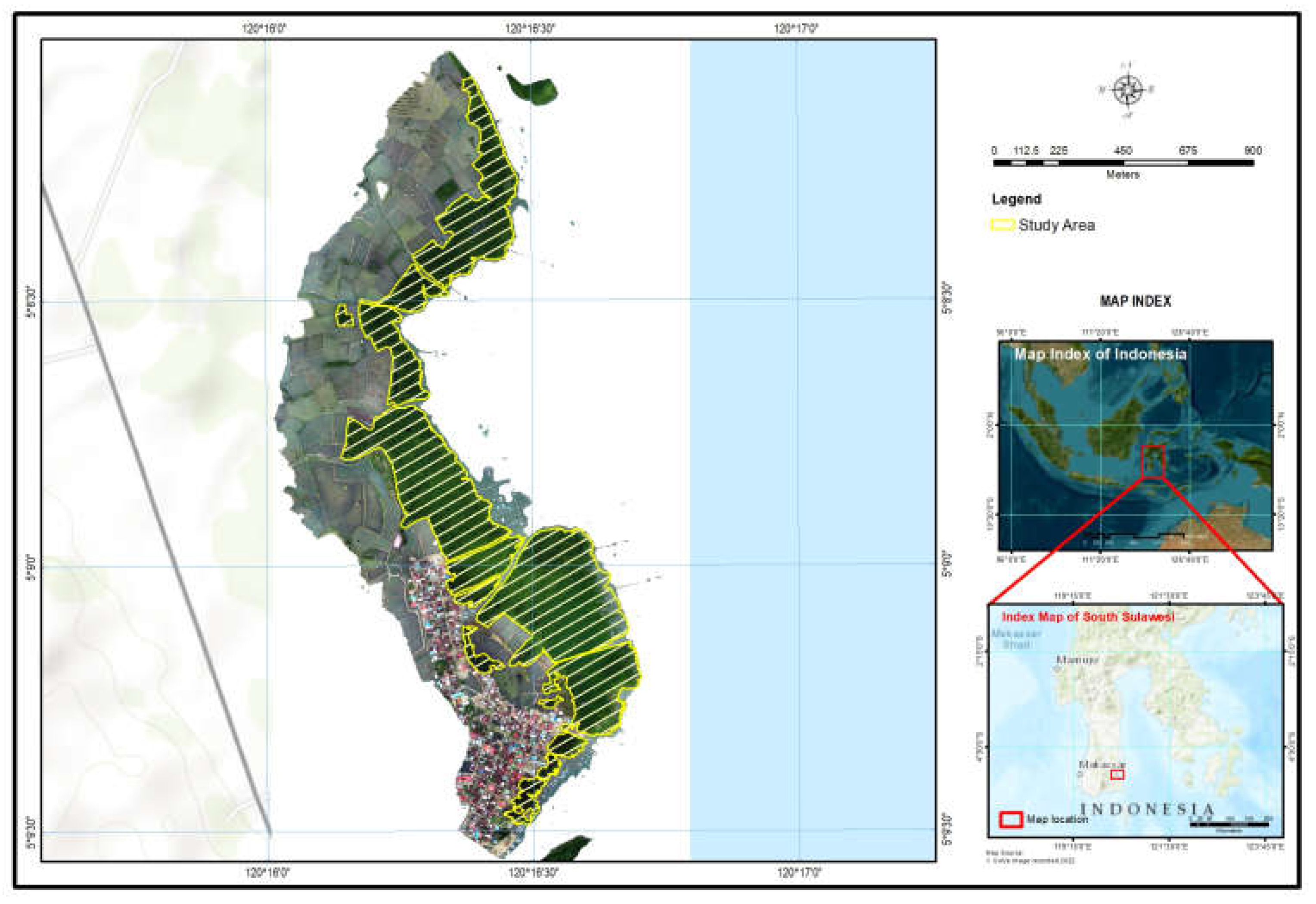
Figure 2.
a) High resolution image from ortho mosaic with resolution 7.03 cm/pixel, b) DSM with resolution 14.01 cm/pixel.
Figure 2.
a) High resolution image from ortho mosaic with resolution 7.03 cm/pixel, b) DSM with resolution 14.01 cm/pixel.
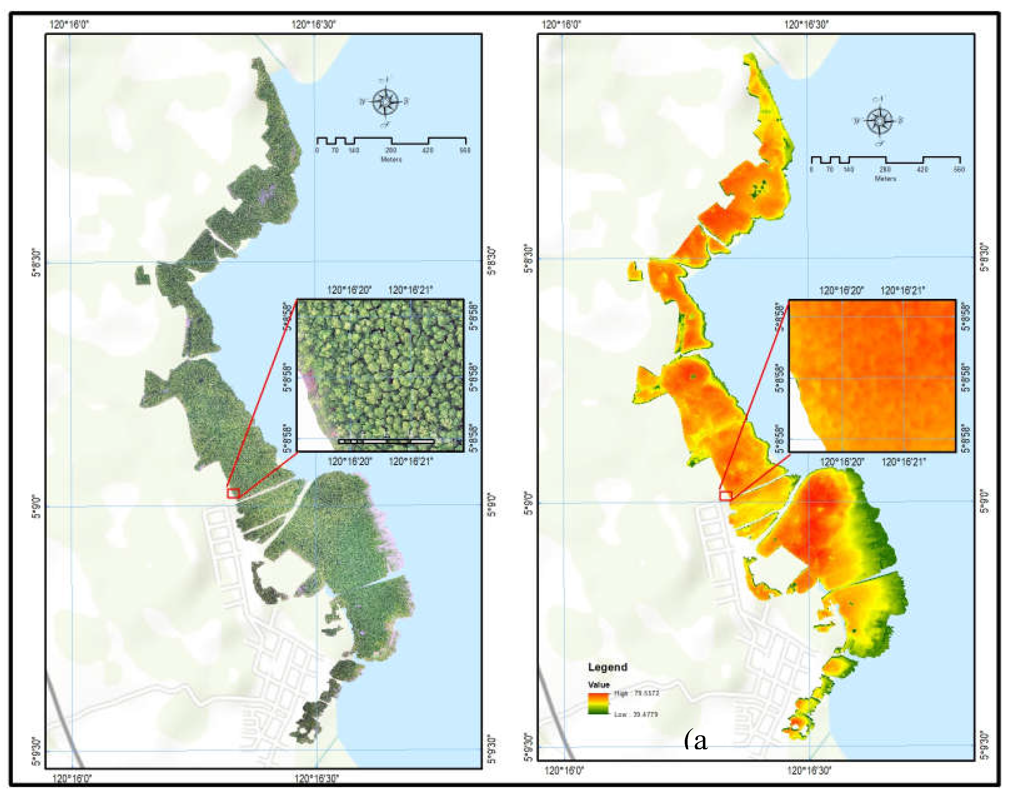
Figure 4.
Interpretation result using support vector machine.
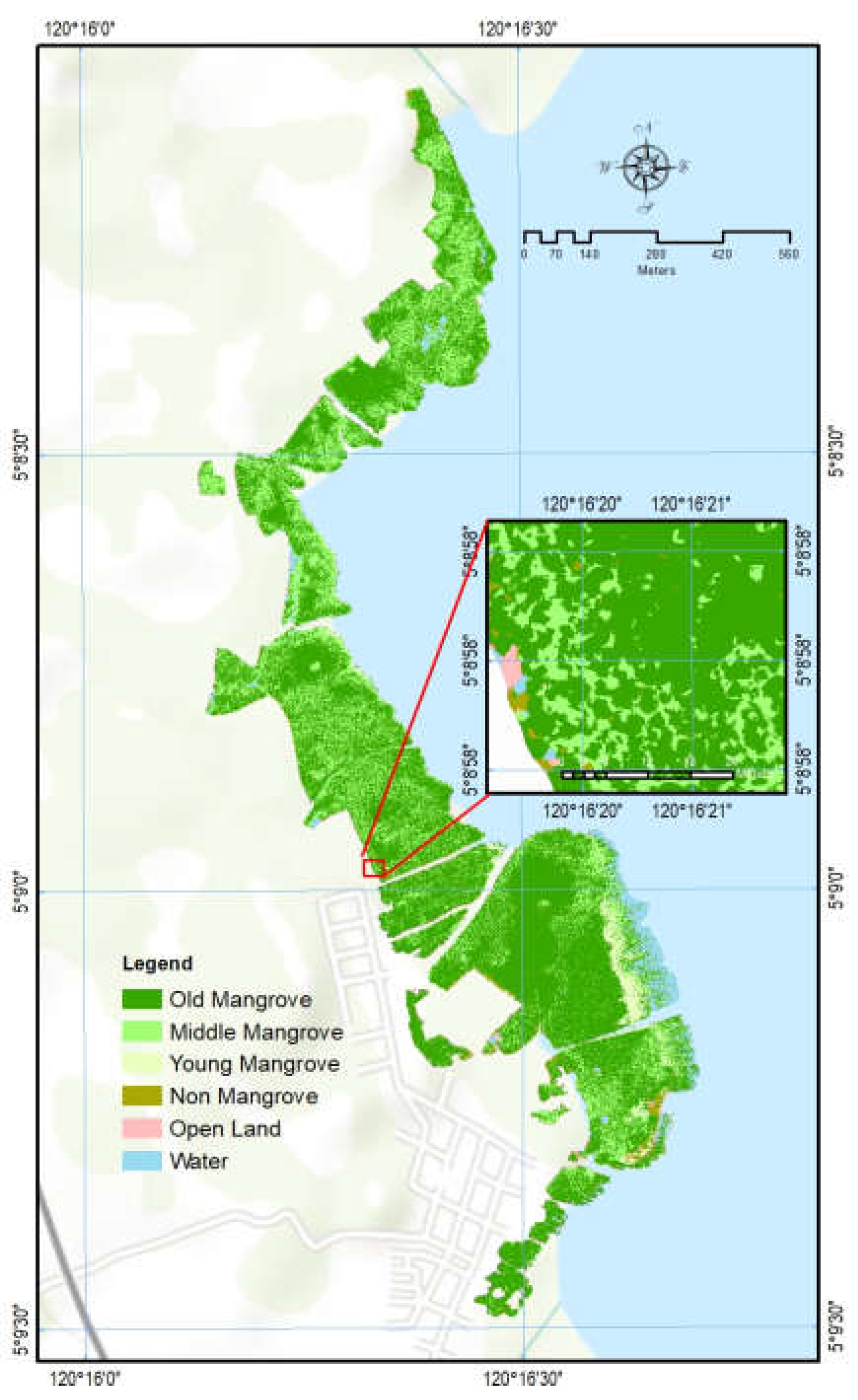
Figure 5.
a) DSM from UAVs image, b) DSM as real high.
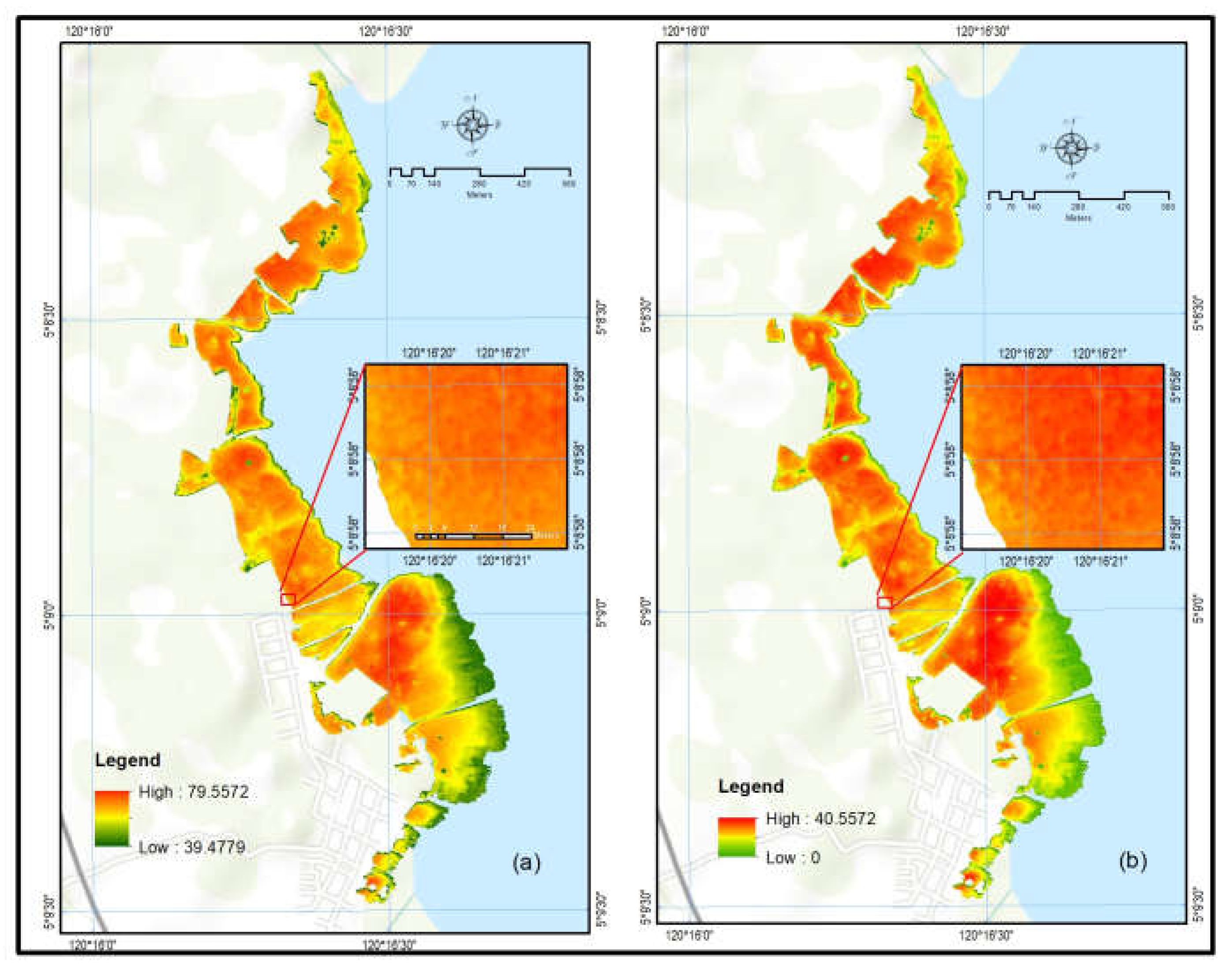
Figure 6.
Vertical classification using data DSM (Tree Height).
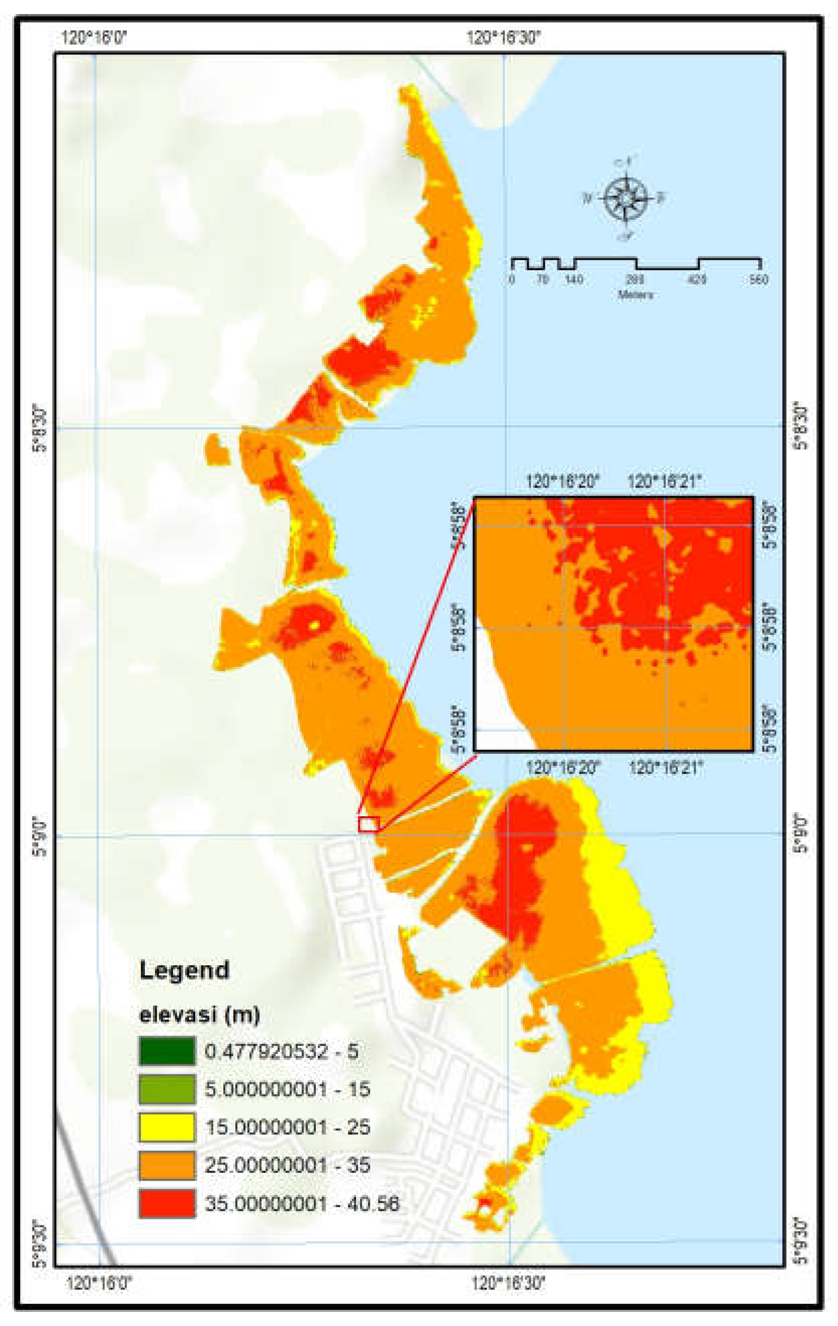
Figure 7.
Horizontal and vertical interpretation.
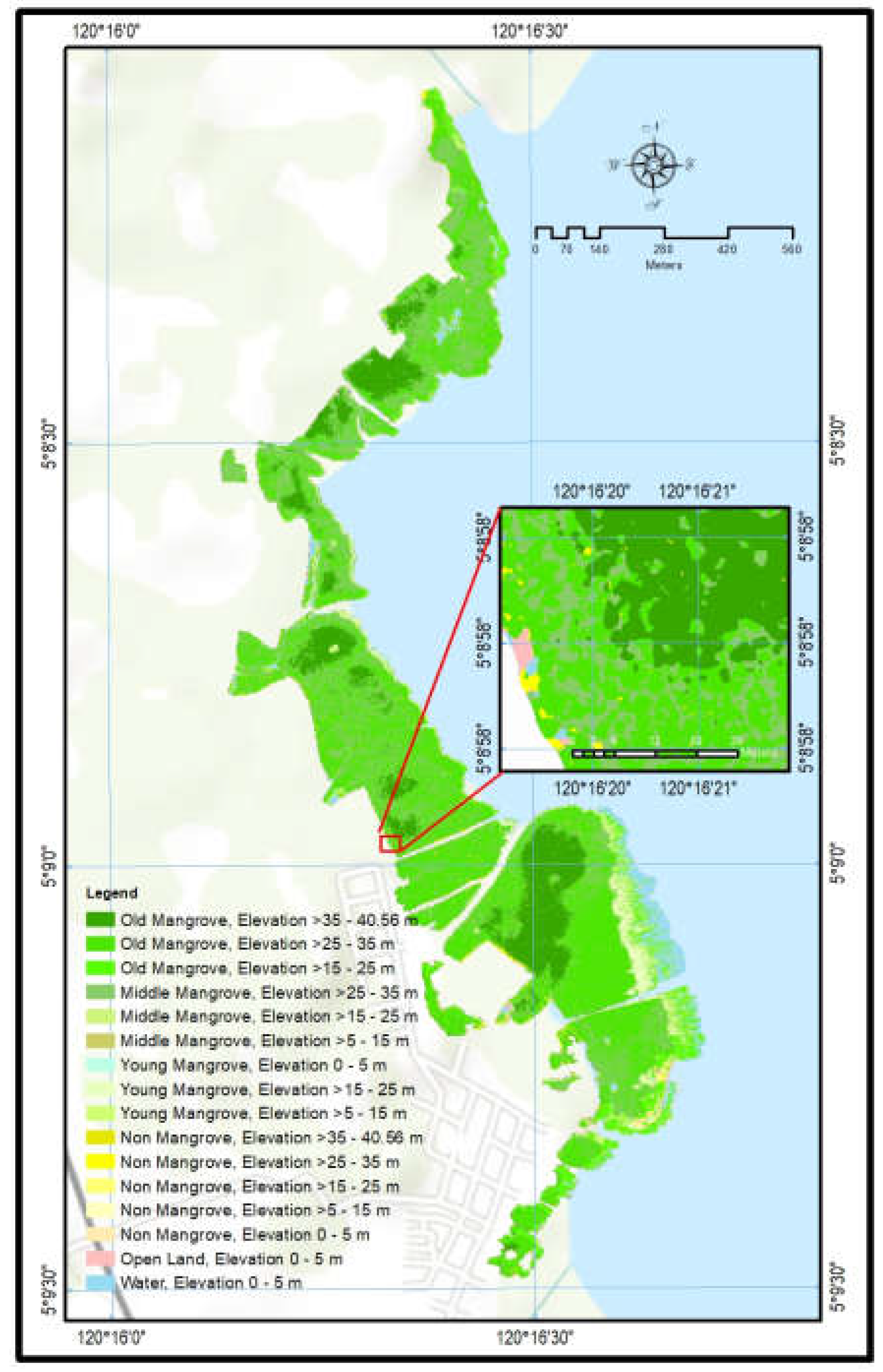

Table 1.
Area of Horisontal Classification.
| Number | Horizontal Classification | Area (hectares) | Percentage |
|---|---|---|---|
| 1 | Old Mangrove | 35.432 | 62.94 |
| 2 | Young Mangrove | 1.381 | 2.45 |
| 3 | Middle Mangrove | 15.538 | 27.60 |
| 4 | Non-Mangrove | 1.206 | 2.14 |
| 5 | Open Land | 0.448 | 0.80 |
| 6 | Water | 2.293 | 4.07 |
| Grand Total (hectares) | 56.297 | ||
Table 2.
Area of Vertical Classification Using DSM (Tree Height).
| Number | Vertical Classification | Area (hectares) | Percentage |
|---|---|---|---|
| 1 | 0 - 5 m | 2.744 | 4.87 |
| 2 | >5 - 15 m | 0.125 | 0.22 |
| 3 | >15 - 25 m | 7.480 | 13.29 |
| 4 | >25 - 35 m | 38.284 | 68.00 |
| 5 | >35 - 40.56 m | 7.663 | 13.61 |
| Grand Total (hectares) | 56.297 | ||
Table 3.
Area of Vertical-Horizontal Classification Mangrove in Tongke-tongke and Samataring Village.
Table 3.
Area of Vertical-Horizontal Classification Mangrove in Tongke-tongke and Samataring Village.
| Number | Vertical-Horizontal Class | Area (hectares) | Percentage |
|---|---|---|---|
| 1 | Old Mangrove, Elevation >35 - 40.56 m | 7.606 | 13.51 |
| 2 | Old Mangrove, Elevation >25 - 35 m | 24.436 | 43.40 |
| 3 | Old Mangrove, Elevation >15 - 25 m | 3.390 | 6.02 |
| 4 | Middle Mangrove, Elevation >15 - 25 m | 2.194 | 3.90 |
| 5 | Middle Mangrove, Elevation >25 - 35 m | 13.241 | 23.52 |
| 6 | Middle Mangrove, Elevation >5 - 15 m | 0.102 | 0.18 |
| 7 | Young Mangrove, Elevation >15 - 25 m | 1.368 | 2.43 |
| 8 | Young Mangrove, Elevation >5 - 15 m | 0.010 | 0.02 |
| 9 | Young Mangrove, Elevation 0 - 5 m | 0.003 | 0.01 |
| 10 | Non-Mangrove, Elevation >15 - 25 m | 0.528 | 0.94 |
| 11 | Non-Mangrove, Elevation >25 - 35 m | 0.607 | 1.08 |
| 12 | Non- Mangrove, Elevation >35 - 40.56 m | 0.057 | 0.10 |
| 13 | Non- Mangrove, Elevation >5 - 15 m | 0.013 | 0.02 |
| 14 | Non- Mangrove, Elevation 0 - 5 m | 0.0004 | 0.001 |
| 15 | Open Land, Elevation 0 - 5 m | 0.448 | 0.80 |
| 16 | Water, Elevation 0 - 5 m | 2.293 | 4.07 |
| Grand Total (hectares) | 56.297 | ||
Disclaimer/Publisher’s Note: The statements, opinions and data contained in all publications are solely those of the individual author(s) and contributor(s) and not of MDPI and/or the editor(s). MDPI and/or the editor(s) disclaim responsibility for any injury to people or property resulting from any ideas, methods, instructions or products referred to in the content. |
© 2024 by the authors. Licensee MDPI, Basel, Switzerland. This article is an open access article distributed under the terms and conditions of the Creative Commons Attribution (CC BY) license (http://creativecommons.org/licenses/by/4.0/).
Copyright: This open access article is published under a Creative Commons CC BY 4.0 license, which permit the free download, distribution, and reuse, provided that the author and preprint are cited in any reuse.


