

Submitted:
01 June 2024
Posted:
04 June 2024
You are already at the latest version
Abstract
Climate change and over-exploitation are imposing unprecedented threats to the groundwater resource. Globally, groundwater reserves have depleted to the extent that well yield have decreased, pumping cost have risen, and land have irreversibly subsided. In Malawi, groundwater quantity is a national problem, specifically in Mzimba district due to severe droughts. In this study, the spatial and temporal trends of groundwater depletion was assessed using Gravity Recovery and Climate Experiment (GRACE) data and Land Surface Models (LSM) from Global Land Data Assimilation System (GLDAS) and Global Surface Water Explorer (GSWE). The results show that 1. Groundwater storage is depleting at an average rate of-1.0 ± 0.06 cm yr-1(0.1043 km3yr-1) in the study area with high rate of up to -1.2 cm yr-1(0.12516 km3 yr-1) in the western side and as low as –0.4 cm yr-1(0.04172 km3 yr-1) in the eastern part. 2. Groundwater storage increases from -13 cm in November up to 15 cm between May and April. 3. Drought is the primary cause of such depletion trends with correlation between active evapotranspiration and groundwater depletion, and downward surface shortwave radiation and groundwater depletion, at -0.577 and -0.678 respectively. The results from the study reveals the need for the scientific community and the general public to consider groundwater recharge strategies specifically by mitigating climate change to reduce prolonged droughts. The study suggests the need to establish a stand-alone groundwater assessment and monitoring authority for enhanced conservation efforts of the water resource in the country.
Keywords:
GRACE
; Groundwater
; Storage
; Depletion
; Land Surface Model
1. Introduction
For the past few decades, the world has experienced unprecedented growth in the economic gains of groundwater use. Groundwater development for household, industrial, as well as agricultural purposes has inevitably caused a worldwide explosion of growth. Globally, groundwater provides 36% of potable water, 42% of water for irrigation agriculture, and 24% water for direct industrial supply [8]. In the SADC region, about 70% of people rely on groundwater as their only source of water. In Malawi, estimates show that 65% of population depends on groundwater for domestic use, where rural population counts for 80%, and 20% urban population [4]. In Mzimba District, 3.7 billion MWK was invested in the development of groundwater between 2017 and 2022 [15,16].
However, in many parts of the world, groundwater reserves have depleted to the extent that well yields have decreased, pumping costs have risen, water quality has deteriorated, aquatic ecosystems have been damaged, and land has irreversibly subsided.
In Africa there are few long-term groundwater data to document the evolution of groundwater response to abstraction. Despite the limited studies, those available have pointed out instances of local depletion and have demonstrated the intermittent patterns of groundwater recharge in semi-arid regions [19]. Being a natural water resource supporting the development of the continent, [7] affirms that groundwater resources in Africa is facing increasing threat of depletion from urbanization, industrial development, agricultural and mining activities. In the Nairobi aquifer system of Kenya, for example, groundwater level declined by 4 m on average over the entire aquifer area and up to 46 m below Nairobi in 2020, due to increasing urbanisation [7].
It is a national crisis; Malawi’s groundwater resource is inevitably threatened by a complex interplay of natural and anthropogenic factors. On one hand, the escalating population growth has led to a substantial rise in groundwater pumpage. On the other hand, adverse impacts of climate change have significantly reduced groundwater replenishment. Additionally, the nation's water resources are under severe threat under watershed degradation due to the changing climate, as evidenced by reports from organizations such as WaterAid on Malawi Country Profile, 2022 [31]; World Bank on Malawi Overview 2023 [32]; UpGro on Aquifer overview of Malawi, 2020 [27].
As groundwater depletion continues worldwide, its impacts worsen, portending the need for objective analysis of the problem and its possible solutions. This study, therefore, analyses the temporal trends of groundwater storage depletion in the study area spanning a period of 2002 to 2022 and the spatial distribution of groundwater depletion across different regions within Mzimba District, and further suggests future options for evaluation and proposes policies that would adversely help in managing groundwater depletion in a changing physical and social landscape.
2. Method and Materials
Study Area
Mzimba District is located on the northwestern part of the Rift Valley Escarpment of Lake Malawi in the Northern Region. The District stretches with an approximate distance of 300 km from north to south and about 80 km from east to west. It has 10 TAs (Figure 1) and 4 Sub-TAs that assist in water resource management through Area Development Committees (ADC). The District has a total land area of 10,430 square kilometers, which is 7.8% of the whole land area of the country (118,484 square kilometers).
Population in Mzimba District is estimated at 610, 944 as of 2018. The District has a yearly temperature of 23.130C (0.11% higher than Malawi averages) and its temperature variation is determined by its topography. The climate of Mzimba is greatly influenced by its location in the tropical zone and its altitude, and the occurrence of El Nino and La Nina Phenomena. The district has generally, warm tropical climate and receives about 177.87 mm of rainfall with 159.08 rainy days (48.58% of the time) annually. The rainy season usually last from November to April and the main rain bearing systems are the Inter-Tropical Convergence Zone (ITCZ) and the Congo Air Mass. In the Viphya plateau areas of Khosolo and Champhira, the rainy season often extends to May. On the other hand, high average monthly rainfall of 600 mm falls on the Viphya Plateau and Mzuzu and the lowest average monthly rainfall of 200 mm falls on the western plain area of Euthini in TA Chindi and Embangweni in TA M’mbelwa.
Geomorphology of the Study Area
Mzimba District is divided into four topographical units namely; Upper South Rukuru Valley which extends from the Zambian Border to about longitude 33030’E with a mean elevation of 1220 masl and a few inselberg features. The Viphya Plateau which forms the western side plateau defined by the escarpement overlooking the Kasitu valley. Central Mzimba Hills, a built of hilly ground along and to the west of the watershed between the South Rukuru and Kasitu basins. The Kasitu Valley which comprise of the Kasitu river rising on the Viphya escarpment in the Mtanga Tanga Forest Reserve and transverse the area in the northerly direction its course being determined by the major fault which marks the western edge of the Viphya Plataeu and Upper Kasitu Valley. The District has three drainage systems; South
Rukuru River System which drains TA M’mbelwa, Mzikubola, Mzukuzuku, Chindi and TA Mpherembe. Kasitu River System which drains the northern part of the west Viphya scarp, flowing northwards in its fault-controlled valley. Luwelezi-Dwangwa River System which drains TA Mabulabo and TA Khosolo located at the southeastern extreme of the District.
Hydrogeology of the Study Area
Groundwater in the district occurs in water table and semi-confined aquifer system. Because of thin clay inter-layering in the alluvial deposits and clay overburdens over the saprolite zone in the plateau of Mzimba, the groundwater storage in most plateau areas appear in the semiconfined conditions and at places where there is no soil cover on the saprolite zone and in the dambos, it appears as water aquifer.
Mzimba aquifer system is associated with two major units which store exploitable amount of groundwater. These are the weathered and fractured basement and the localised alluvial and colluvial aquifer. The weathered and fractured basement is a high yielding aquifer with and annual recharge rate of 12 to 62 mm, and the localised alluvial and colluvial aquifer which is a low yielding aquifer with an annual recharge rate of 9 to 56 mm.
Figure 2.
Hydrogeologic information of the study area; (a) Soil textural classes, (b) geology, (c) aquifer types.
Figure 2.
Hydrogeologic information of the study area; (a) Soil textural classes, (b) geology, (c) aquifer types.
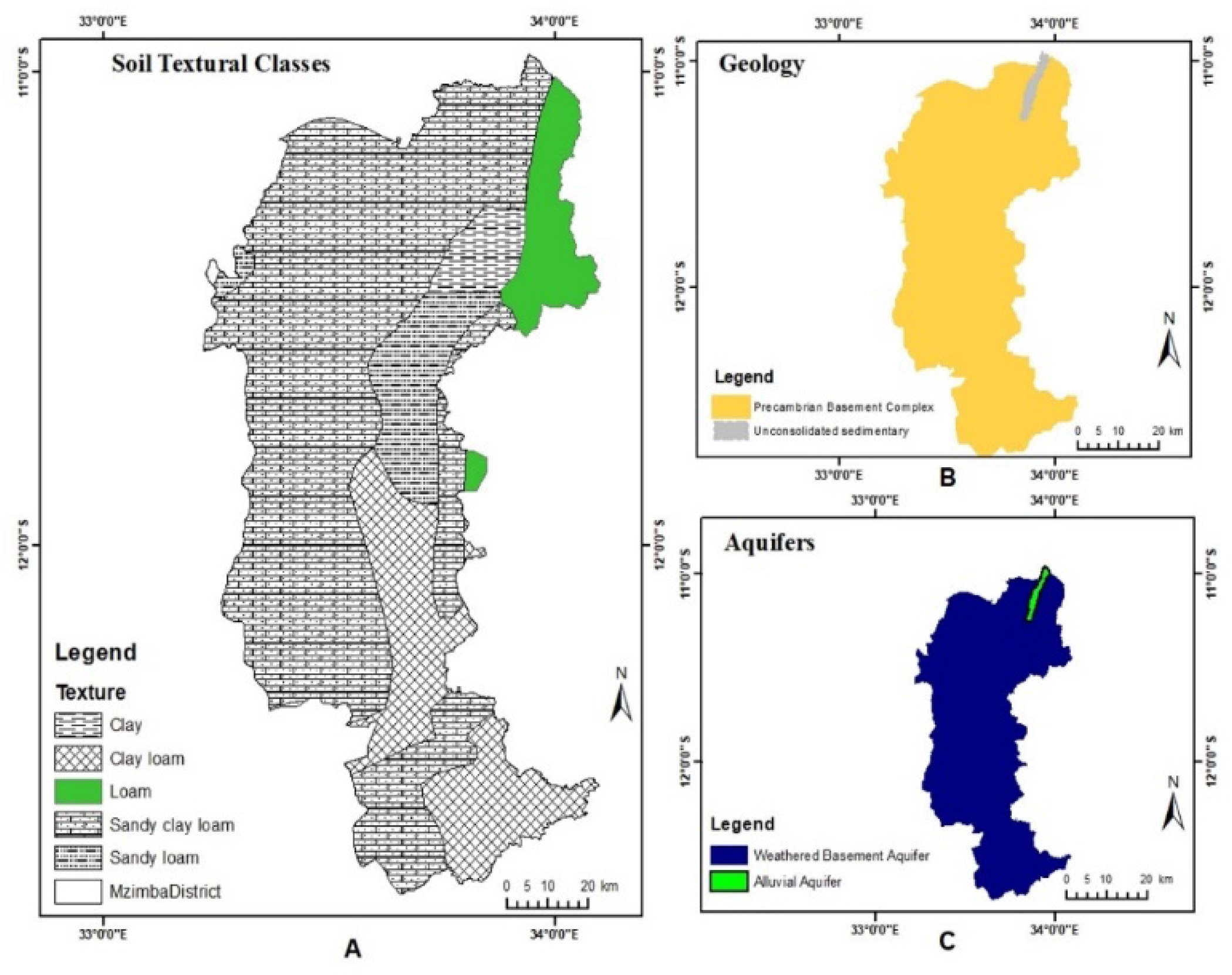

Table 1.
Summary of recharge estimates made for the weathered basement and aquifers in Malawi. (National Water Resource MasterPlan Report, Annex 6).
Table 1.
Summary of recharge estimates made for the weathered basement and aquifers in Malawi. (National Water Resource MasterPlan Report, Annex 6).
| Method |
Recharge to weathered Basement aquifer (mm) |
Recharge to alluvial aquifer (mm) |
| Hydrograph Analysis | 15-80 | 3-80 |
| Groundwater Level Fluctuations | 10-35 | 10-50 |
| Groundwater Flow | 4-36 | 13-38 |
| Catchment Water balance | 18-96 | - |
| Average range | 12-62 | 9-56 |
Dataset
Groundwater Storage Depletion Analysis
In recent papers of groundwater storage depletion using GRACE, researchers have used a mixture of numerical and categorical dataset that influence water balance to learn downscaling models [17,34] such as evapotranspiration, land use/land cover, precipitation, snow, digital elevation models and models from Global Land Data Assimilation System. This section highlights datasets used in this study in the estimation of groundwater storage depletion.
i. Gravity Recovery and Climate Experiment data (Iwe thickness)
Gravity Recovery and Climate Experiment (GRACE) is unique in the sense that it is the first mission of satellite remote sensing which is directly applicable in the regional groundwater storage estimation [27]. The mission consists of twin satellite (Figure 3) flying in tandem in a polar, nearly circular orbit at an altitude of 500 km with an inter-satellite separation of roughly 220 km [22]. The satellites accurately obtain estimates of Earth’s gravity information which is inferred from the inter-satellite distance and is measured within micrometer (µm) accuracy using a K-Band microwave system [22,28]. Potential error sources such as atmospheric drag and satellite perturbations are measured and filtered out using readings from a highly accurate, on-board accelerometer while precise positioning is determined using on-board GPS receivers [20,26].
The primary objective of GRACE mission is to measure variation in Earth’s gravity field with high possible accuracy. Gravity is not the same across different regions of the Earth, it varies due to differences in the distribution of mass within the Earth’s systems. When the satellites pass along regions with high mass such as mountain, the leading satellite accelerate followed by the trailing satellite which then catches up (Figure 4). The acceleration is due to low gravitational field being recorded at the time caused by isostasy of the mountain mass [13]. Again, when the satellite passes through land/oceans, the inter-satellite distance decreases due to deceleration caused by the dense gravitation anomaly of the underlying crusts. These changes in the inter-satellite distance recorded is then fed into the regression processors to determine changes in the Earth’s gravity at NASA’s data processing facility in Jet Propulsion Laboratory (JPL), Austin Centre for Space Research at the University of Texas and the GeoForschungZentrum (GFZ) (Which translate to German Research Centre for Geosciences) in Germany.
Data acquired by the GRACE satellites which is, then, processed as gravitation field information is the K-Band Level-1 radar data. The gravity field data is available as Level 2 products in the form of spherical harmonic coefficients [25]. The Level 2 spherical harmonic coefficient is further processed to express the gravity field changes as equivalent water thickness (available as Iwe thickness variable). The term ‘equivalent water thickness’, or Iwe, is derived from the idea that these hydrological mass changes are concentrated in a very thin layer on the Earth’s surface [20,30] whose vertical extent is measured in centimetres [20]. Changes in Iwe are available as Level-3 Terrestrial Water Storage (TWS) solutions after further filtering and correction for post-glacial rebound [20] with the spatial resolution of 10 x 10.
Estimation of Groundwater Storage Depletion at Local Level
The traditional methods of estimating groundwater storage (GWS) primarily rely on observation wells, which provide high-resolution estimates for local areas. However, in regions like Malawi where observation wells are generally limited and barely functional, it is difficult to measure regional groundwater storage variations. In addition, measurements of groundwater level taken at a single location might not represent the situation in the entire area of study. The emergence of the Gravity Recovery and Climate Experiment (GRACE) has brought new frontiers in the study of groundwater storage at the local scales [25]. The new technology makes possible real-time and dynamic monitoring of groundwater storage variations. GRACE measurements have been used successfully to study groundwater depletion trends in large water basins, sub-basins, regions, and sub-regions worldwide [24]. The practical application of GRACE data for local water resources management, however, has been limited because of the low spatial resolution of 10 x 10 applicable to area over 150,000 km2 [22], which makes it challenging to link GRACE estimates to local-scale [2]. Thus, downscaling procedures makes such enormous datasets available for use at relatively smaller study areas.
Downscaling Methods
Downscaling is a common issue in the subject of satellite remote sensing [9]. Normally, the downscaling methods include dynamic and statistical downscaling [3,5,14]. Dynamic downscaling is used to construct a regional numerical model at higher spatial resolution; thus, it can be applied in local areas at smaller scales. Statistical downscaling methods, on the other hand, are applied using observations made over many years to establish the relationship between large-scale factors and data from small-scale observations [6,15]. Unlike dynamic downscaling methods, which require complex data from various sources, statistical downscaling is relatively simple and widely used.
There are few studies on downscaling GRACE data. Most studies use hydrological models to make assimilation of GRACE’s terrestrial water storage (TWS). For example, [12] introduced a new ensemble-based Kalman filter approach to assimilate GRACE data into the WaterGAP Global Hydrology Model, and the downscaled GRACE-derived TWS can be achieved based on the optimized model [23]. Sun in 2013 developed a machine learning model, the Artificial Neural Network to downscale GRACE-derived GWS in different regions across the United States [1].
GRACE Data Downscaling Procedures Using Machine Learning
Extracting groundwater trends from GRACE data at high resolution requires implementing downscaling methods, as discussed above. Since the GRACE launch in 2002, there have been various research studies that have presented various methods to downscale GRACE data, to extract total water storage (TWS) and groundwater storage (GWS) data at higher spatial resolutions. Recently, there has been an increase in the number of statistical downscaling models that have leveraged machine learning approaches [15,16,23], [34,35]. Using these advanced machine learning methods, various researchers have demonstrated significant increases in GRACE resolution without sacrificing the underlying physical realism [29]. The most popular machine learning downscaling model is thee Artificial Neural Network.
Artificial Neural Network (ANN) Algorithm
Artificial Neural Network is non-linear machine learning model inspired by the structure and functions of biological neural networks in the human brain [33,34]. ANN consist of interconnected nodes, or neuron in layers: An input layer, one or more hidden layers and an output layer (Figure 5). Each neuron receives input signals, processes them using activation functions and produces output signals that are transmitted to other neurons.
ii. Global Land Data Assimilation System, GLDAS (Soil Moisture)
Global Land Data Assimilation System is the project undertaken by the National Oceanic, and Atmospheric Administration (NOAA) and National Aeronautics and Space Administration (NASA). The dataset that comprise of simulated land surface state of surface temperatures, evapotranspiration, sensible heat flux and soil moisture. To simulate land surface state, four offline, uncoupled with atmosphere, land surface models are driven to simulate an enormous amount of satellite and ground-based observations and produces outputs at a spatial resolution of 0.250 and 10 [20]. The four land surface models driven by GLDAS are: NOAH, MOSAIC, Community Led Model (CML) and Variable Infiltration capacity (VIC). The Soil moisture dataset used in this study was obtained using GLDAS land surface model simulations.
iii. Global Surface Water, GSW (Surface Water)
Global surface water dataset was produced from inventories and national descriptions, statistical extrapolation of regional data and satellite imagery. The dataset shows the spatial and temporal distribution of surface water over the past 38 years and is available for download from the Global Surface water in individual tiles of 100 x 100. The website provides two python scripts and a GitHub lick of a script written by Petr Tsymbarovich to download full dataset. This study used the python 2 script to streamline downloading the full datasets. The dataset is also available in six products. The study adopted the monthly water history of the dataset and calculated monthly averages using the following expression.
Table 2.
Secondary sources of datasets.
| Dataset | Units | Type | Spatial resolution | Temporal resolution | Observation Period |
Source |
|---|---|---|---|---|---|---|
|
JPL Level 3 TWS |
Iwe-cm | GRACE observation |
10 | Monthly | Jun 2002 – Jun 2022 |
GRACE Tellus |
| NOAH / MOSAIC soil moisture | Kg/m2 (mm) |
Model Parameter GLDAS Land Surface |
0.250 | Monthly | Jun 2002 – Jun 2022 |
GIOVANNI- GLDAS |
| GSW surface water | m | 0.0120 | Monthly | Jun 2002 – Jun 2022 |
GWSE surface water |
iv. TerraClimate data
TerraClimate is a global dataset of monthly climate and climatic water balances for global terrestrial surfaces spanning from 1958 to 2022. It has a temporal resolution of one month and a spatial resolution of 0.040 which is approximately 4 km. The dataset has variables which includes Actual evapotranspiration, soil moisture that influence groundwater recharge, Palmer Drought Severity Index, Downward shortwave surface radiation, runoff, Snow water equivalence, Precipitation and Water deficit. This study adopted actual evapotranspiration and surface shortwave surface radiation to derived the relationship between climate related issues specifically drought with groundwater storage trends.
Table 3.
Description and justification of TerraClimate attribute adopted in this Study.
| Attribute/ Band | Name | Units | Descript-ion | Justificat-ion |
|---|---|---|---|---|
| aet | Actual Evapo-Transpiration | mm | Derived using a one-dimensional soil water balance model | It is one of the leading indicators of drought mainly affecting the recharge of groundwater. |
| srad | Downward shortwave surface radiation |
W. m- 2 | It is a hydrologic variable that influences drought |
Method
Download Data from Remote Sources
Data downloading was streamlined using the siphon python package from target data servers [21].
GRACE data was downloaded from the Jet Propulsion Laboratory’s (JPL) OPEnDAP data server [18]. The GLDAS soil moisture data was download from Goddard Earth Sciences Data and Information Service Center (GES DISC) [10], GSW surface water data was downloaded from the Global Surface Water Explorer and TerraClimate data was downloaded from Climatology lab.
All datasets were downloaded into specific directory within the raw data directory.
- i.
- Pre-Processing Sourced Data
For ease of use, the downloaded data was all standardised as NetCDF data format. rasterio python packages was used to standardise monthly mean values and units.
- ii.
- Generating Model Inputs
The data quality of the model inputs is a significant driver of the model results [12]. Model inputs was arranged in tabular format for convenience.
- iii.
- Artificial Neural Network Models
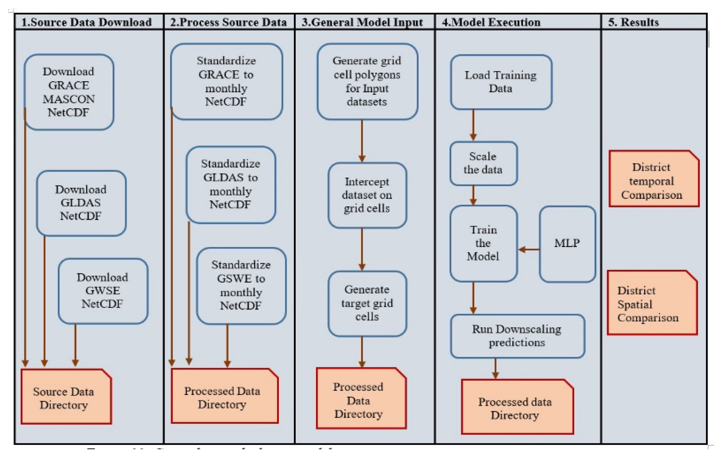
Multi-Layer Perceptron (MLP) Regressor Model was adopted as discussed above. The multilayer perceptron (MLP) is a supervised learning algorithm [23]. The algorithm can learn a non-linear function approximator for either classification or regression. The model comprises of the input layers, hidden layers (can be one or more non-linear layers) and the output layer. This is one of the most used neural network machine learning models. It uses backpropagation with a few different activation functions to compute the final output. The model run was based on the groundwater budget approach (Figure 6) and equation 2
where ΔGWS is the estimated changes of groundwater storage change, ΔTWS is the GRACE’s terrestrial water storage, ΔSM is the change in GLDAS’s soil moisture and ΔSW is the change in GWSE’s surface water
Table 4.
Python packages used in this study for GRACE data and Land Surface Models (LSM) analysis.
| Python Package | Library Description | Justification |
|---|---|---|
| matplotlid | Used for creating static, animated and interactive visualisation |
Visualisation of the dataset |
| siphon | Provide access to data such as satellite data hosted by remote servers and allows access to retrieve them without manually downloading them especially large files | Downloading the dataset |
| rasterio | Used for reading geospatial datasets | Used to standardise monthly averages of the dataset |
Figure 7.
Groundwater depletion model execution process.
To quantify depletion rate at the District level the following equation was used
where Dr is depletion rate per unit area, GWDepletion is groundwater depleted and HGArea is aquifer area
Results and Discussion
Spatial and Temporal Groundwater Depletion
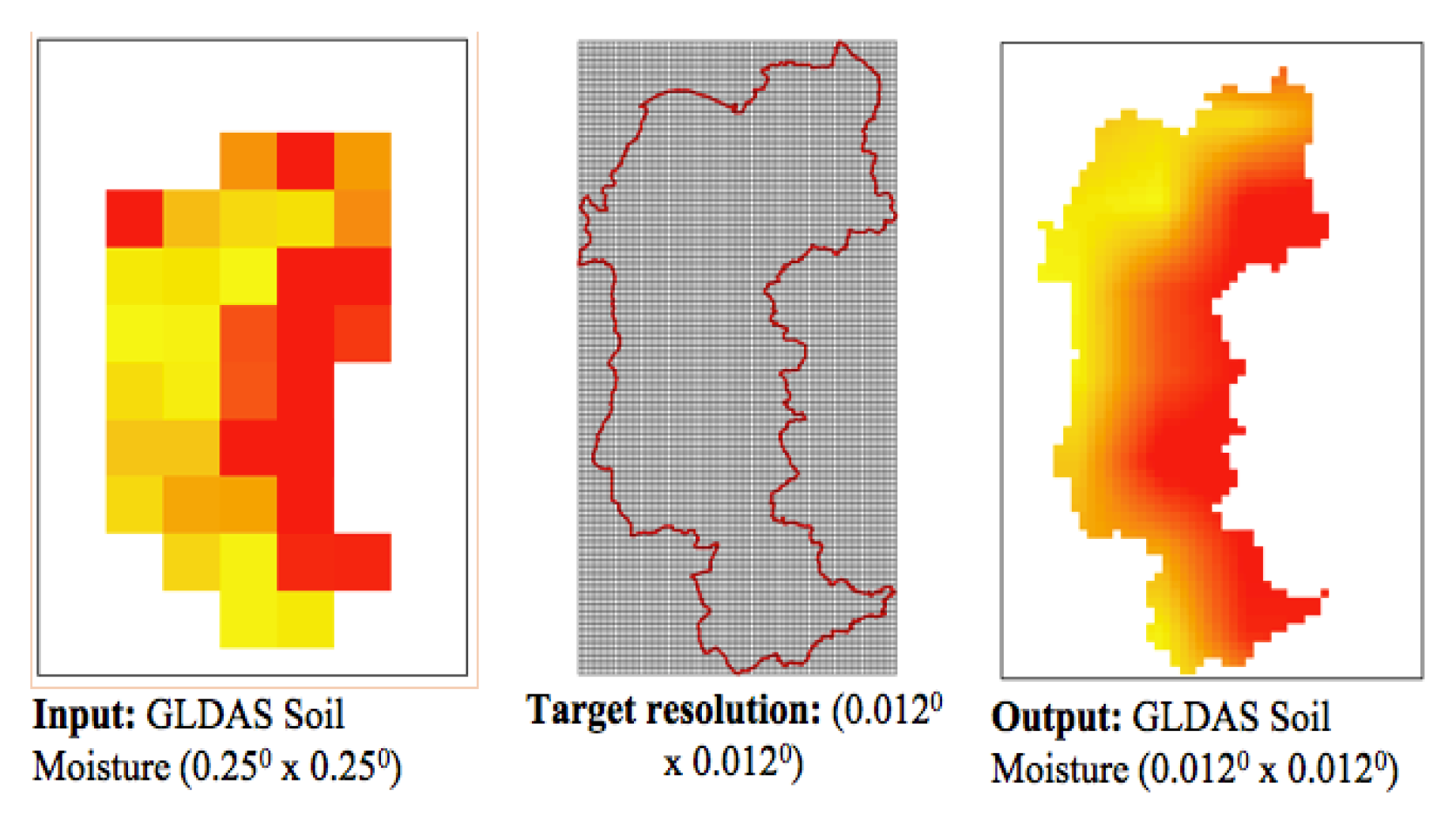
The vector-based grid cells for two datasets (GRACE Iwe thickness and GLDAS soil moisture) undergoing downscaling process was generated using the xagg python package. The package converts the data using area weighted average from the relative overlap between the grid pixels and polygons. The output polygon size is influenced by its distance from another polygon. It generates the grid polygons based on the bounding box extent of the input grid data. An additional intersection was applied on the xagg polygons to obtain a high-quality visualisation of the final grid cell polygons with highest spatial resolution. The vector-based intersection of the grid cell resolution of GRACE Iwe thickness and GLDAS soil moisture was at 0.0120. Figures 16 and 17 show outputs of the grid cell polygons for GRACE Iwe thickness and GLDAS soil moisture respectively.
Figure 8.
GRACE TWA Iwe thickness downscaling procedure.
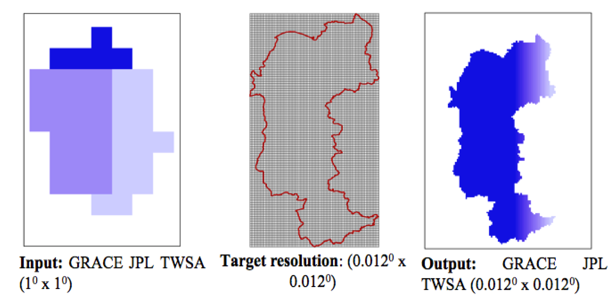
Figure 9.
GLDAS NOAH Soil Moisture downscaling procedure.
MLP Model Execution
MLP model was executed using the following factors; Batch size of 23,642, Size of hidden layer = (23, 16, 10, 4, 2) which was determined using the trial and error method, Activation function adopted was the Rectified linear unit, Solver used was the Limited-memory Broyden–Fletcher– Goldfarb–Shanno algorithm (LBFGS) with the learning rate of 0.0011. The batch size was selected based on the number of observations per timestep. The solver LBFGS is a well-validated solver, and was chosen as it is recommended for datasets with a smaller sample of training data.
Monthly Variations of Groundwater Storage
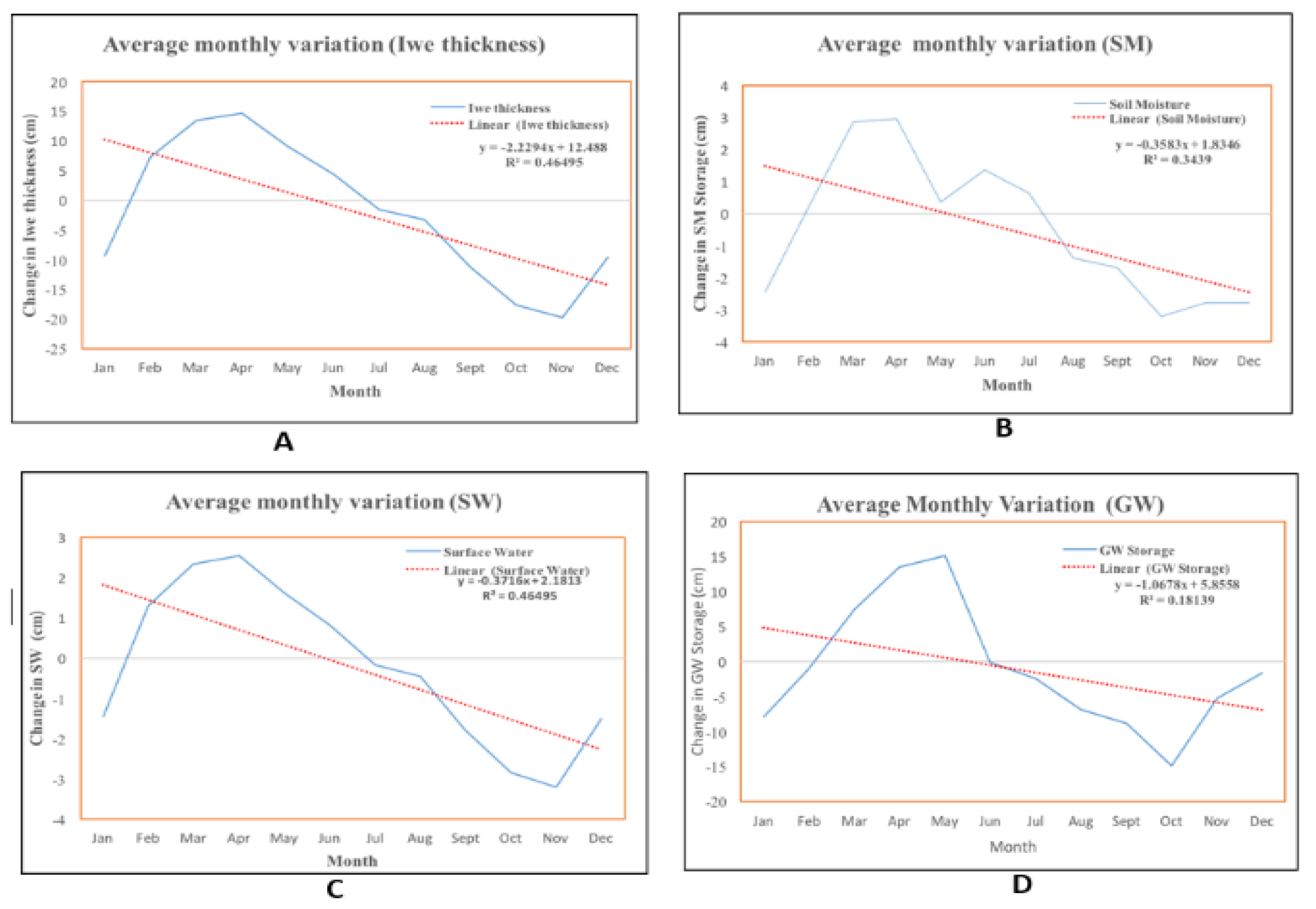
All dataset (GRACE Iwe thickness, GLDAS soil moisture, GWSE surface water, and groundwater storage) exhibit an increase from the month of January peeks between the month of March and April where it starts to decline to the negative amplitudes. The trends are due seasonal changes from hot dry to cold wet, respectively.
Figure 10.
Monthly variation of GWS depletion.
Time Series (Temporal) of Groundwater Storage
Figure 11 shows groundwater storage time series for the aquifer system of Mzimba District. The groundwater depletion trend was found to be -1.0 ± 0.06 cm yr-1. Mzimba District roughly covers an area of 10,430 km2 which corresponds to a yearly depletion rate of 0.1043 km3yr-1 which is equivalent to 2.086 km3 (2.086 x 10¹² litres) of groundwater lost between 2002 and 2022. Thus, the water table in the District is approximated to lower by 50 cm in the next three decades.
Groundwater storage was depleting steadily between 2002 and 2006 (with the highest positive amplitude of 19 cm and negative amplitude of -21 cm). The trend exhibits a fairly increasing groundwater storage between 2007 and 2010 with the highest amplitude recorded at 21 cm. A sharp decrease of groundwater storage is noticed from October 2010 to June 2020. Many justifications can be drawn from such declining trend, but this study, hypothetically attribute this depletion trend to adverse drought occurrences that hit the district between 2010 and 2020 especially the 2017 drought.
Spatial Distribution of Groundwater Storage Depletion
Spatial map of groundwater storage distribution (Figure 12) show that the eastern part which constitute of Kasitu Valley running through northerly direction along the Viphya escarpment throught to Mzuzu and the Viphya plateau (Chikangawa Forest Plantation) has a low depletion rate of roughly –0.4 cm yr-1 (0.04172 km3 yr-1). The western plain where the country borders with Zambia, and the Vwaza marsh along Mpherembe/Kazuni plain has a high depletion rate of groundwater storage of up to -1.2 cm yr-1 (0.12516 km3 yr-1).
The hypothetical rationale behind strong depletion trends in the western plain and Kazuni region is in twofold. On one hand, the regions have a hot and dry climate which impose huge impact on groundwater replenishment processes. On the other hand, the region is predominantly covered by sandy clay and loam soils which are vulnerable to occurring evaporation triggered by the hot and dry climate.
Drivers to Groundwater Storage Trend
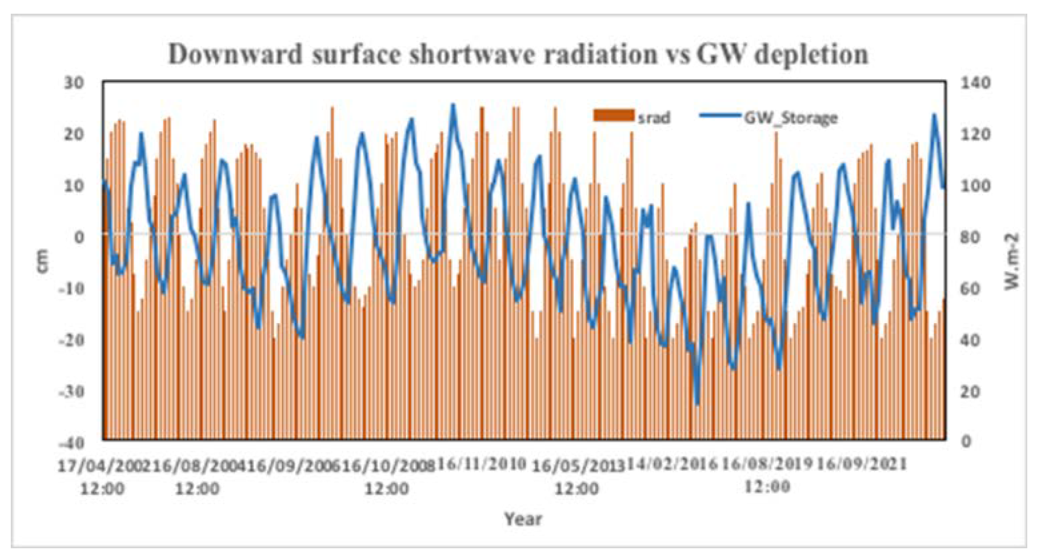
Primary causes to groundwater depletion trends globally have been attributed to climate change and anthropogenic activities such as borehole and shallow well exploitation and irrigation agriculture. However, irrigation and borehole groundwater exploitation are not pronounced in the study area. Thus, this study established the relationship between the drought determining parameter such as active evapotranspiration and downward surface shortwave radiation and groundwater storage trends (Figure 13 and Figure 14). As discussed earlier downward surface shortwave radiation is the driving force of many global ecological, hydrological, biophysical, and biochemical processes and is a key in modelling weather and climate systems while active evapotranspiration is the actual rate at which water vapour is returned to the atmosphere soil and by plants and is a direct indicator of drought due to its influence on groundwater recharge.
As the Figure 13 show, groundwater storage and active evapotranspiration exhibit a strong negative correlation of -0.58. The increase in aet contribute to declining trends of groundwater storage. The strong negative amplitude of groundwater storage observed in 2016 is accompanied by strong impulse of increase in aet. Similarly, groundwater storage and downward surface shortwave radiation exhibit a negative correlation of -0.68. Increase in the downward surface shortwave radiation decrease groundwater storage.
Conclusions
Groundwater in Mzimba District is depleting at a rate of -1.0 ±0.6 cm yr-1. The 2002-2022 does show a strong depletion trend in groundwater storage that is of great concern to the studies of current water supply and food security. Studies such as [11,27] have proven the impacts of similar groundwater depletion trends.
Interesting results obtained in this study, based on GRACE, GLDAS and GSWE, is that the highest rates of groundwater depletion are taking place in the western plains where Malawi borders with Zambia, and the Mpherembe/Kazuni area of the District which is mainly drained by South Rukuru river, one of tributaries of Lake Malawi. The area is also characterised by sandy loam soil. This study, therefore, hypotheses that the such depletion on this part of district is heavily affect by the hot and dry climate which adversely enhances evapotranspiration due textural characteristics of the soil in the region. The eastern part of the District which constitute Mzuzu city and the Chikangawa Forest Plantation has the lowest groundwater depletion rate, hypothetically due to the cold and wet climatic conditions.
With regards to drivers to groundwater storage trends, the study used drought indicators to establish the impact of climate change on groundwater storage. The rationale behind the exclusion of anthropogenic drivers was that, theoretically, borehole exploitation and irrigation agriculture is not pronounced as a threat to groundwater resource in the District. However further study should delve into establishing the possible links. Drought indicators used in this study includes active evapotranspiration (aet) and downward surface shortwave radiation (srad) which negative correlation of -0.58 and -0.68 respectively.
Recommendations
General Recommendation
GRACE data with its spatial resolution of 10 x 10 is applied in the assessment of groundwater storage depletion of aquifer areas that are more than 150,000 km2. However, GRACE data can be applied in the assessment of groundwater storage depletion of local aquifers areas lower than the recommended area by employing downscaling and resampling procedures.
Studies that are quantifying groundwater storage depletion needs an observation period of at least 20 years
Recommendation Aimed at Policymakers
Drought is such a heavy contributor to such depletion trends in the District. Enhancing climate change mitigation measures to reduce prolonged droughts would be vital in attaining groundwater sustainability in the quest of addressing the Malawi Vision 2063 enabler 4
Currently, the information stored in GRACE data as far as Malawi groundwater assessment is concerned, is literally untapped. In this regard, Policymakers can promote and fund further research studies eyeing on the contribution GRACE data can do in groundwater resource management in the country.
This study did not employ on-site data from observation and monitoring wells with the very reason that data for only one observation well was available for the study. Thus, only one observation well is functional in the District. Renovating these wells to enhance data collection of groundwater level would be vital
Groundwater management by multi –purpose bodies such as the Ministry of Water and Sanitation, and the National Water Resources Authority does not quench the entire need for the assessment and monitoring of the water resource. In this regard, establishing stand-alone groundwater assessment and monitoring authority would help foster groundwater management efforts at national level.
Areas for Further Study
Quantify groundwater depletion trends at national level is not known. Replicating the study for the national wide quantification of the groundwater resource would be vital to enhance a national wide effort of groundwater resource management
Literature has proven that anthropogenic factors such irrigation, borehole/wells exploitation has impact on the quantitative status of groundwater level in different regions across the globe. Thus, assessing the impact of anthropogenic factors on groundwater level changes would be vital in leveraging groundwater resources management
Analyzing the potential of combining the strengths of multiple machine learning techniques, as well as integrating physics-based models with data-driven approaches for downscaling GRACE data for local aquifer assessment would increase the accuracy of the data in quantifying groundwater level status.
Analyse possible connection between the GRACE-based groundwater storage time series with climatic phenomena such as the Congo air mass, and InterTropical Convergence Zone
References
- Agarwal, V.; Akyilmaz, O.; Shum, C.K.; Feng, W.; Yang, T.-Y.; Forootan, E.; Syed, T.H.; Haritashya, U.K.; Uz, (2023). Machine Learning Based Downscaling of GRACE- Estimated Groundwater in Central Valley, California. Science Total Environment., 865,161138.
- Alexandra Gemitzi, Nikos Koutsias and Venkataraman Lakshmi. (2021). A Spatial Downscaling Methodology for GRACE Total Water Storage Anomalies Using GPM IMERG Precipitation Estimates. Xanthi: Democritus University of Thrace.
- Ali, S.; Khorrami, B.; Jehanzaib, M.; Tariq, A.; Ajmal, M.; Arshad, A.; Shafeeque, M.; Dilawar, A.; Basit, I.; Zhang, L. (2023). Spatial Downscaling of GRACE Data Based on XGBoost Model for Improved Understanding of Hydrological Droughts in the Indus Basin Irrigation System (IBIS). Remote Sensing., 15, 873.
- Chavula, G. M. S. (2012). Malawi. Groundwater availability and use in Sub-Saharan Africa: A review of fifteen countries, 78-90.
- Chen, L.; He, Q.; Liu, K.; Li, J.; Jing, C (2019). Downscaling of GRACE-Derived Groundwater Storage Based on the Random Forest Model. Remote Sensing., 11, 2979.
- Delman, A.; Landerer, F (2022). Downscaling Satellite-Based Estimates of Ocean Bottom Pressure for Tracking Deep Ocean Mass Transport. Remote Sensing. , 14, 1764.
- Gaye, C. B., & Tindimugaya, C. (2019). Challenges and opportunities for sustainable groundwater management in Africa. Hydrogeology Journal, 27(3), 1099-1110. GRACE Land Mass Grids (Monthly). (2013). GRACE Tellus. Retrieved from http://grace.jpl.nasa.gov/data/mass.
- Global Environmental Facility (2018). Global Groundwater Resource.
- Gemitzi, A.; Koutsias, N.; Lakshmi, V. A (2019. Spatial Downscaling Methodology for GRACE Total Water Storage Anomalies Using GPM IMERG Precipitation Estimates. Remote Sensing, 13, 5149.
- Gorugantula, S.S.; Kambhammettu, B.P. (2022). Sequential Downscaling of GRACE Products to Map Groundwater Level Changes in Krishna River Basin. Hydrological Sciences, 67, 1846– 1859.
- Goddard Earth Sciences Data and Information Services Center. (2013). NASA. Retrieved from http://disc.sci.gsfc.nasa.gov/.
- Gudivada, V.; Apon, A.; Ding, J (2017). Data Quality Considerations for Big Data and Machine Learning: Going Beyond Data Cleaning and Transformations. International Journal of Software, 10, 1–20.
- Haile, K. H. (2011, March). Estimation of Terrestrial Water Storage in the Upper Reach of Yellow River (Masters). University of Twente, Enschede, NL. Retrieved from www.itc.nl/library/papers_2011/msc/wrem/habte.pdf.
- Milewski, A.M.; Thomas, M.B.; Seyoum, W.M.; Rasmussen, T.C. (2019). Spatial Downscaling of GRACE TWSA Data to Identify Spatiotemporal Groundwater Level Trends in the Upper Floridan Aquifer, Georgia, USA. Remote Sensing, 11, 2756.
- Miro, M.E.; Famiglietti, J.S. (2018). Downscaling GRACE Remote Sensing Datasets to High Resolution Groundwater Storage Change Maps of California’s Central Valley. Remote Sensing, 10, 143.
- M’mbelwa District Council (2017). Socio Economic Profile.
- M’mbelwa District Council (2017). District Development Plan.
- OPeNDAP. Available online: https://www.opendap.org/ (accessed on 7 September 2023).
- Oiro, S., Comte, J. C., Soulsby, C., MacDonald, A., & Mwakamba, C. (2020). Depletion of groundwater resources under rapid urbanisation in Africa: recent and future trends in the Nairobi Aquifer System, Kenya. Hydrogeology Journal, 28, 2635-2656.
- Pradhan, G. P. (2014). Understanding interannual groundwater variability in North India using GRACE (Master's thesis, University of Twente).
- Pedregosa, F.; Varoquaux, G.; Gramfort, A.; Michel, V.; Thirion, B.; Grisel, O.; Blondel, M.; Müller, A.; Nothman, J.; Louppe, G. (2012). Scikit-Learn: Machine Learning in Python. Journal of Machine Learning, 12, 2825–2830.
- Scanlon, B.R.; Zhang, Z.; Save, H.; Wiese, D.N.; Landerer, F.W.; Long, D.; Longuevergne, L.; Chen, J. (2016) Global Evaluation of New GRACE Mascon Products for Hydrologic Applications. Water Resources., 52, 9412–9429.
- Seyoum, W.M.; Kwon, D.; Milewski, A.M. (2019). Downscaling GRACE TWSA Data into High Resolution Groundwater Level Anomaly Using Machine Learning-Based Models in a Glacial Aquifer System. Remote Sensing, 11, 824.
- Rodell, M., Houser, P. R., Jambor, U., Gottschalck, J., Mitchell, K., Meng, C.-J.,Toll, D. (2004). The Global Land Data Assimilation System. Bulletin of the American Meteorological Society, 85(3), 381–394. doi:10.1175/BAMS-85-3-381.
- Rodell, Matthew, Chen, J., Kato, H., Famiglietti, J. S., Nigro, J., & Wilson, C. R. (2006). Estimating groundwater storage changes in the Mississippi River basin (USA) using GRACE. Hydrogeology Journal, 15(1), 159–166. Rodell, Matthew, Velicogna, I., & Famiglietti, J. S. (2009). Satellite-based estimates of groundwater depletion in India. Nature, 460(7258), 999–1002. [CrossRef]
- Tapley, B. D., Bettadpur, S., Ries, J. C., Thompson, P. F., & Watkins, M. M. (2004). GRACE measurements of mass variability in the Earth system. Science, 305(5683), 503–505.
- UpGro (2020). Aquifer overview of Malawi.
- UNIDATA NetCDF. Available online: https://www.unidata.ucar.edu/software/netcdf/ (accessed on 7September 2023).
- Vishwakarma, B.D.; Zhang, J.; Sneeuw, N. (2021). Downscaling GRACE Total Water Storage Change Using Partial Least Squares Regression. Science Data, 8, 95.
- Wahr, J., Molenaar, M., & Bryan, F. (1998). Time variability of the Earth’s gravity field: Hydrological and oceanic effects and their possible detection using GRACE. Journal of Geophysical Research: Solid Earth (1978–2012), 103(B12), 30205–30229.
- WaterAid Malawi (2022). Malawi Country Profile.
- 2023; 32. World Bank Group (2023) Malawi Overview.
- Zhang, G. P., & Qi, M. (2005). Neural network forecasting for seasonal and trend time series. European Journal of Operational Research, 160(2), 501–514.
- Yin, W.; Zhang, G.; Liu, F.; Zhang, D.; Zhang, X.; Chen, S. (2022). Improving the Spatial Resolution of GRACE-Based Groundwater Storage Estimates Using a Machine Learning Algorithm and Hydrological Model. Hydrogeological Sciences, 30, 947–963.
- Zhang, G.; Zheng, W.; Yin, W.; Lei, W. (2020). Improving the Resolution and Accuracy of Groundwater Level Anomalies Using the Machine Learning-Based Fusion Model in the North China Plain. Sensors. 21, 46.
Figure 1.
Location of the area (Mzimba District).
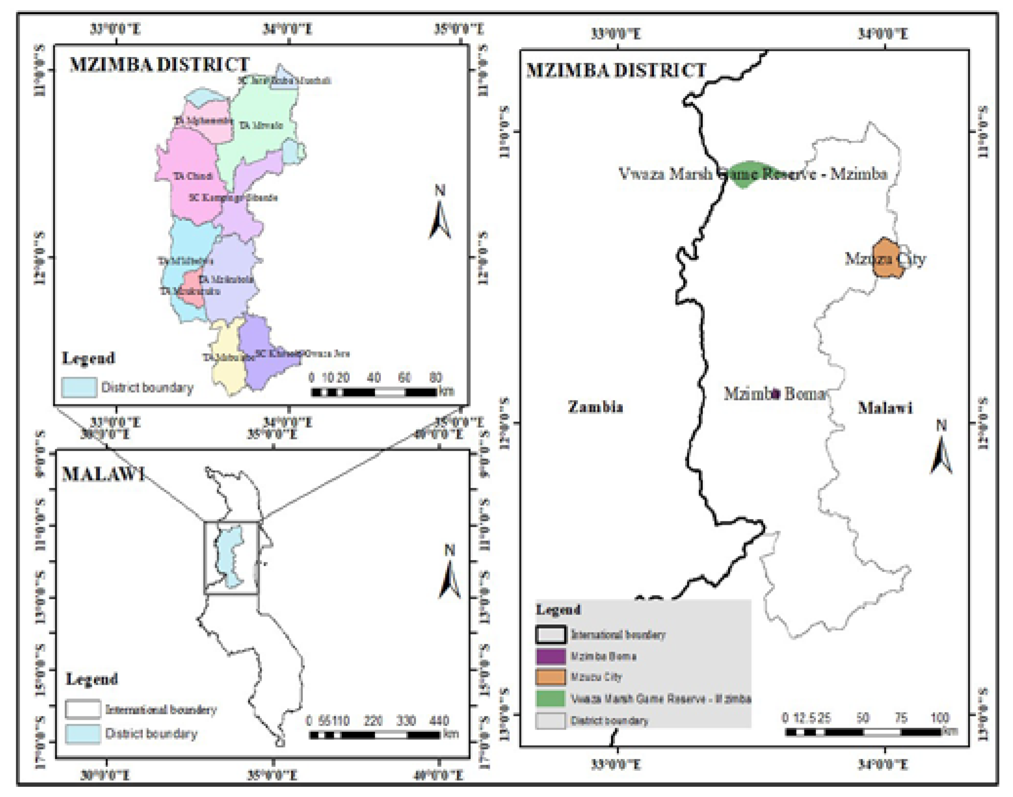
Figure 3.
NASA's Gravity Recovery and Climate Experiment-Follow On (GRACE FO) twin satellites in orbit.
Figure 3.
NASA's Gravity Recovery and Climate Experiment-Follow On (GRACE FO) twin satellites in orbit.
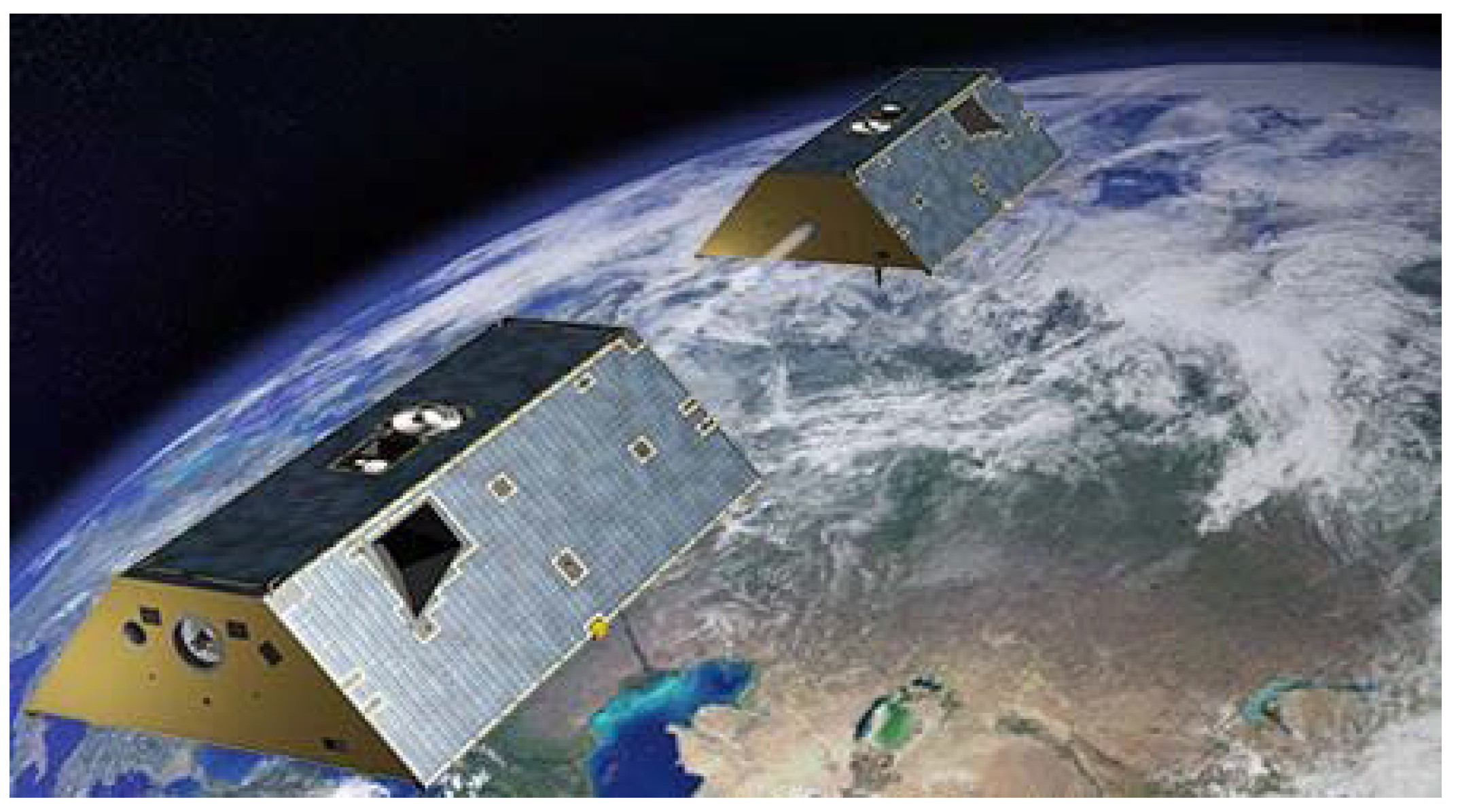
Figure 4.
GRACE twin satellite in orbit: (a) satellites decelerate along the oceans/land due to high gravitational pull, (b) Satellite accelerate along mountains due to low gravitational pulls intercepted by the mass of the mountain due to isostasy.
Figure 4.
GRACE twin satellite in orbit: (a) satellites decelerate along the oceans/land due to high gravitational pull, (b) Satellite accelerate along mountains due to low gravitational pulls intercepted by the mass of the mountain due to isostasy.
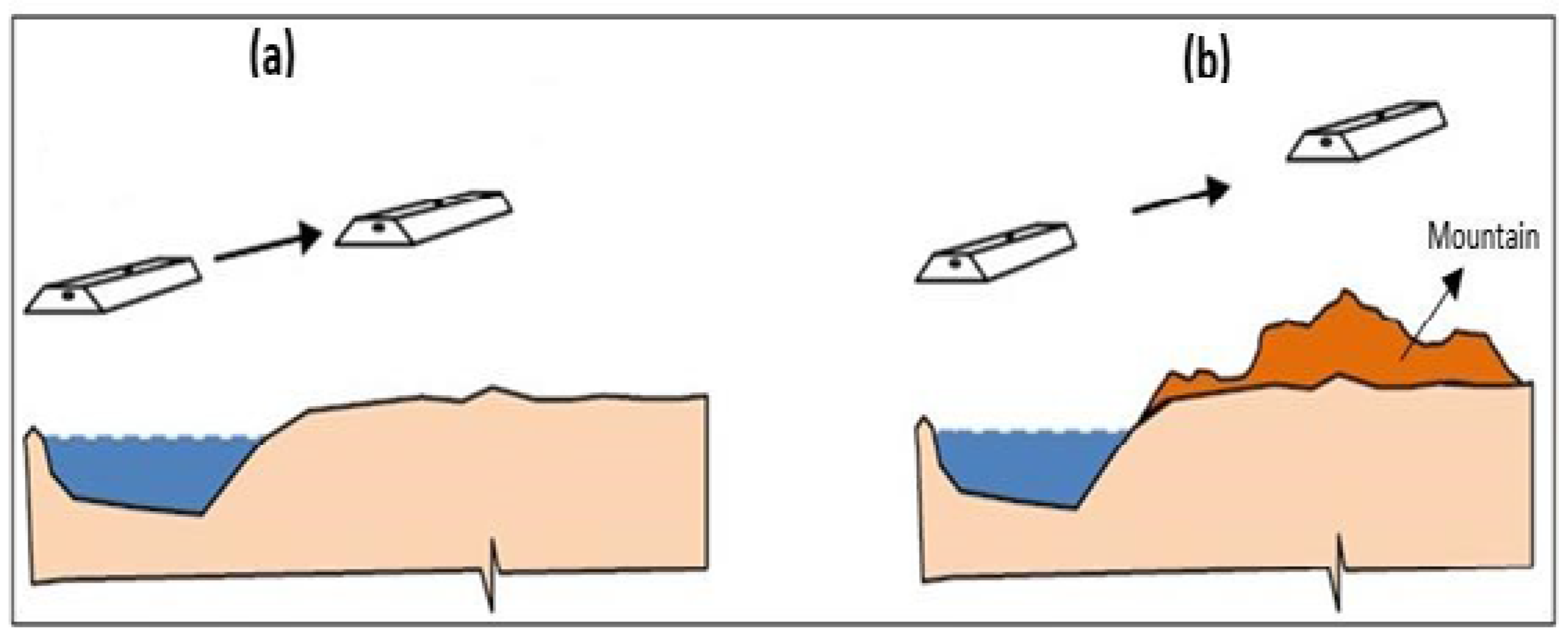
Figure 5.
Conceptual framework of the Artificial Neural Network (ANN) model Input layer receives input data, which is passed onto the hidden layers that processes the input data through weighted connections and apply activation function to produce output signals. The neurons in the generate final output of the ANN model in the output layer.
Figure 5.
Conceptual framework of the Artificial Neural Network (ANN) model Input layer receives input data, which is passed onto the hidden layers that processes the input data through weighted connections and apply activation function to produce output signals. The neurons in the generate final output of the ANN model in the output layer.
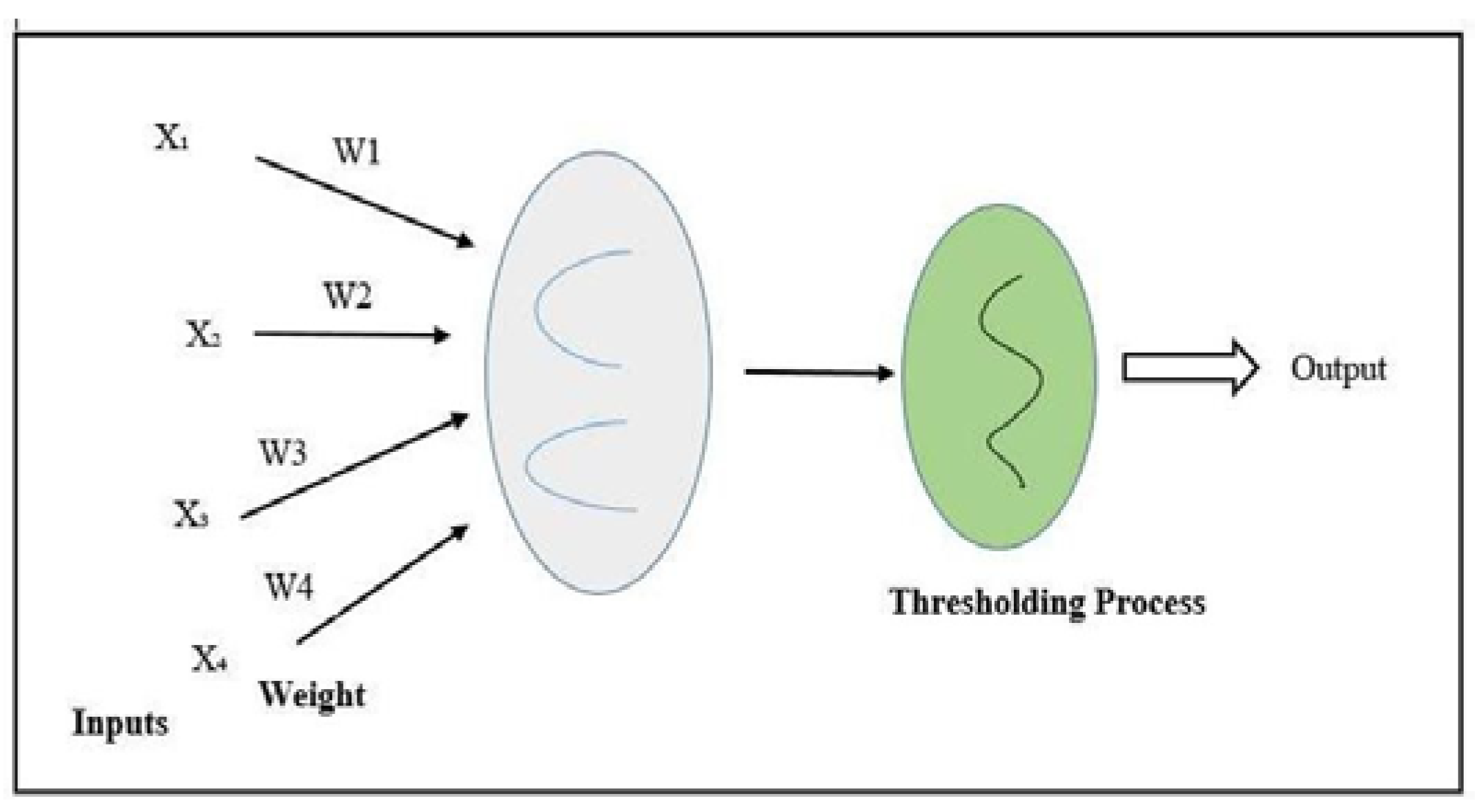
Figure 6.
Conceptual framework of the model for groundwater storage change quantification.
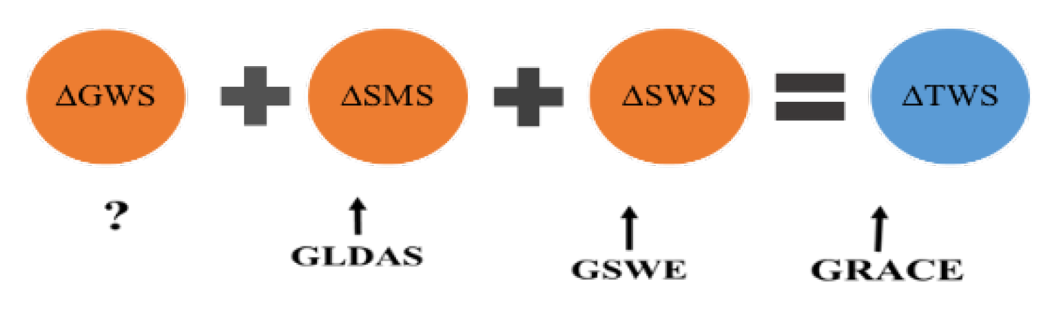
Figure 11.
Temporal of groundwater storage (2002-2022) in the study area.
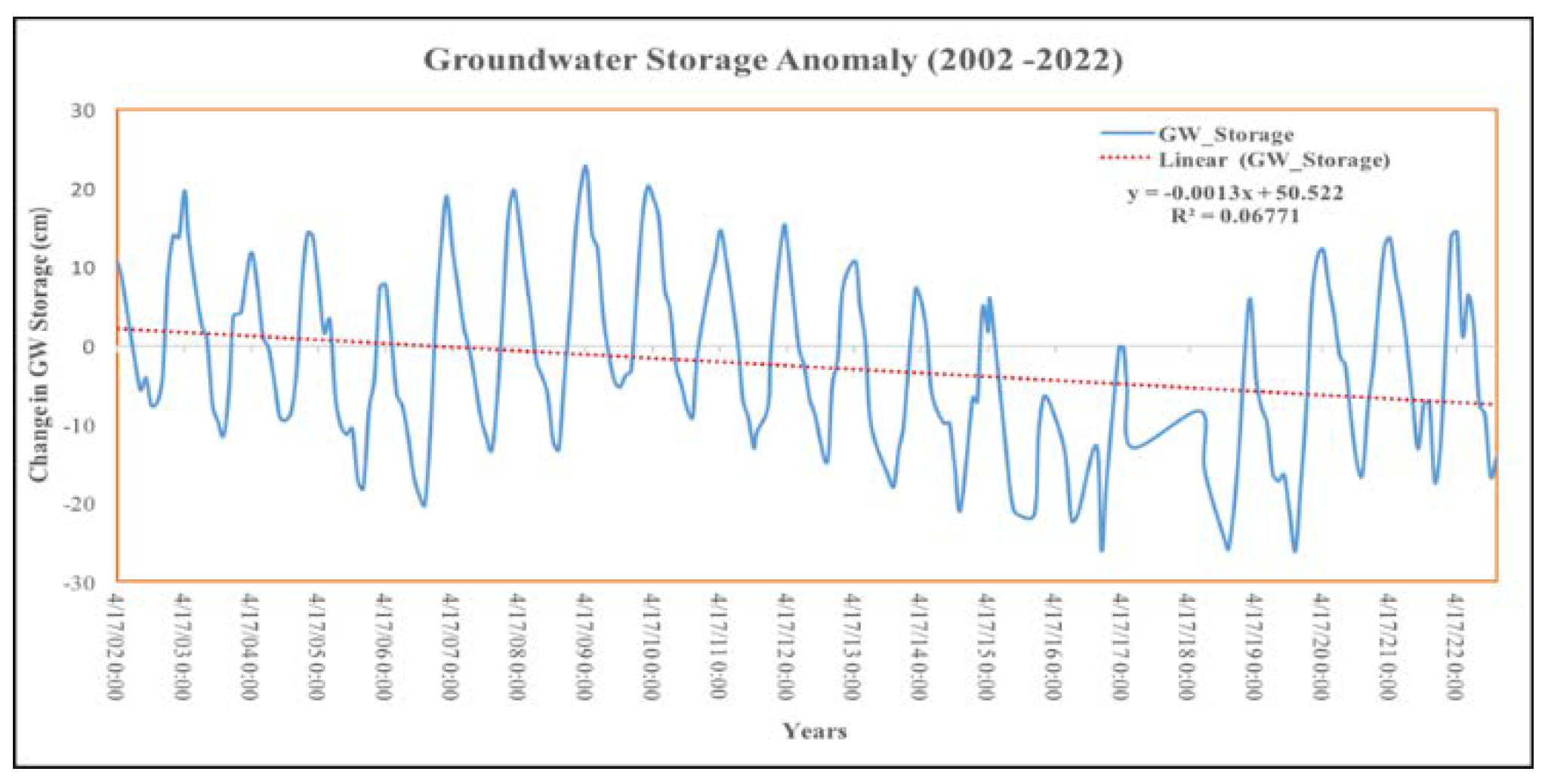
Figure 12.
Spatial distribution of groundwater depletion in the study area.
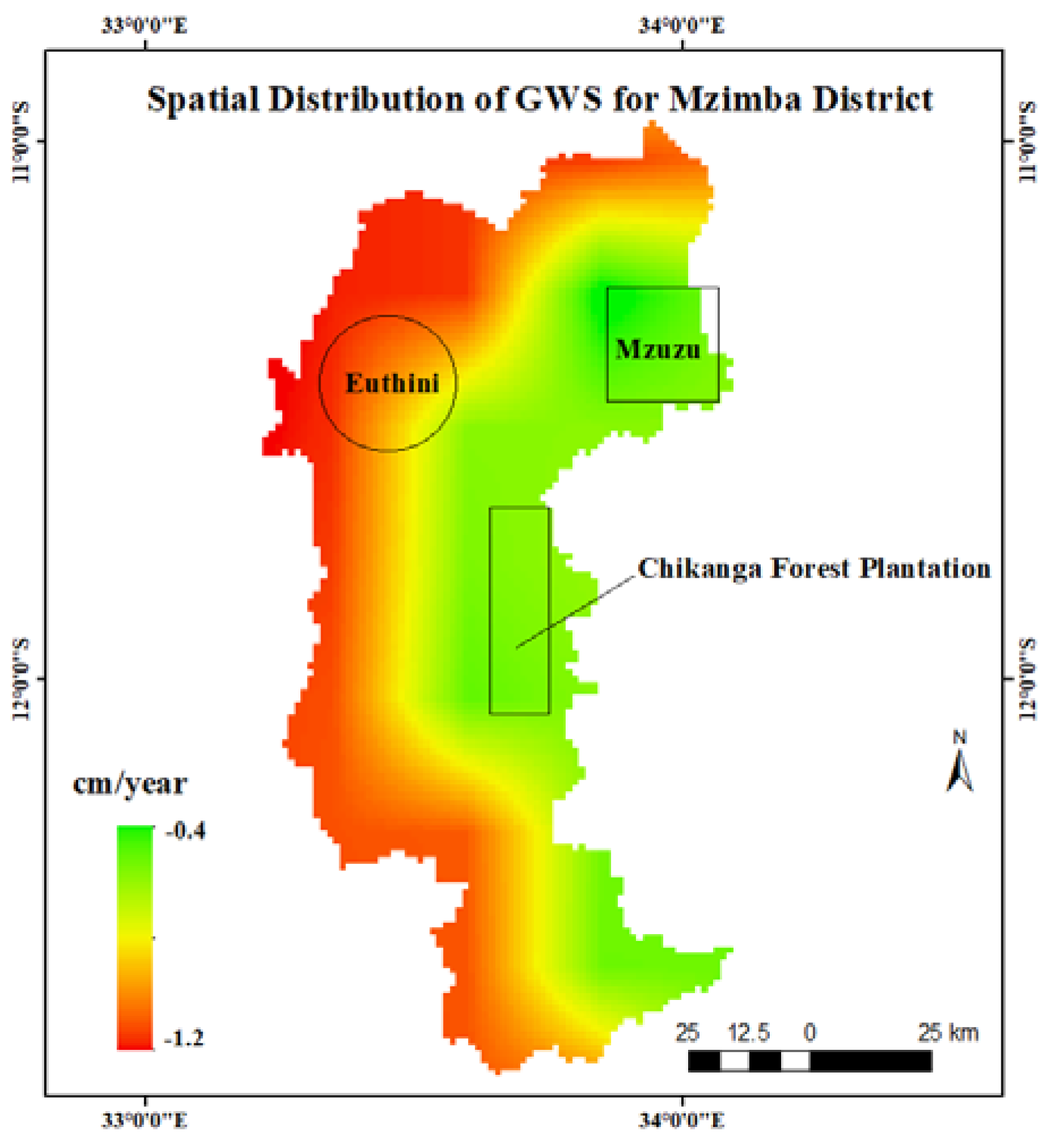
Figure 13.
Linear relationship between TerraClimate's aet and GRACE, GLDAS and GSWE GW depletion.
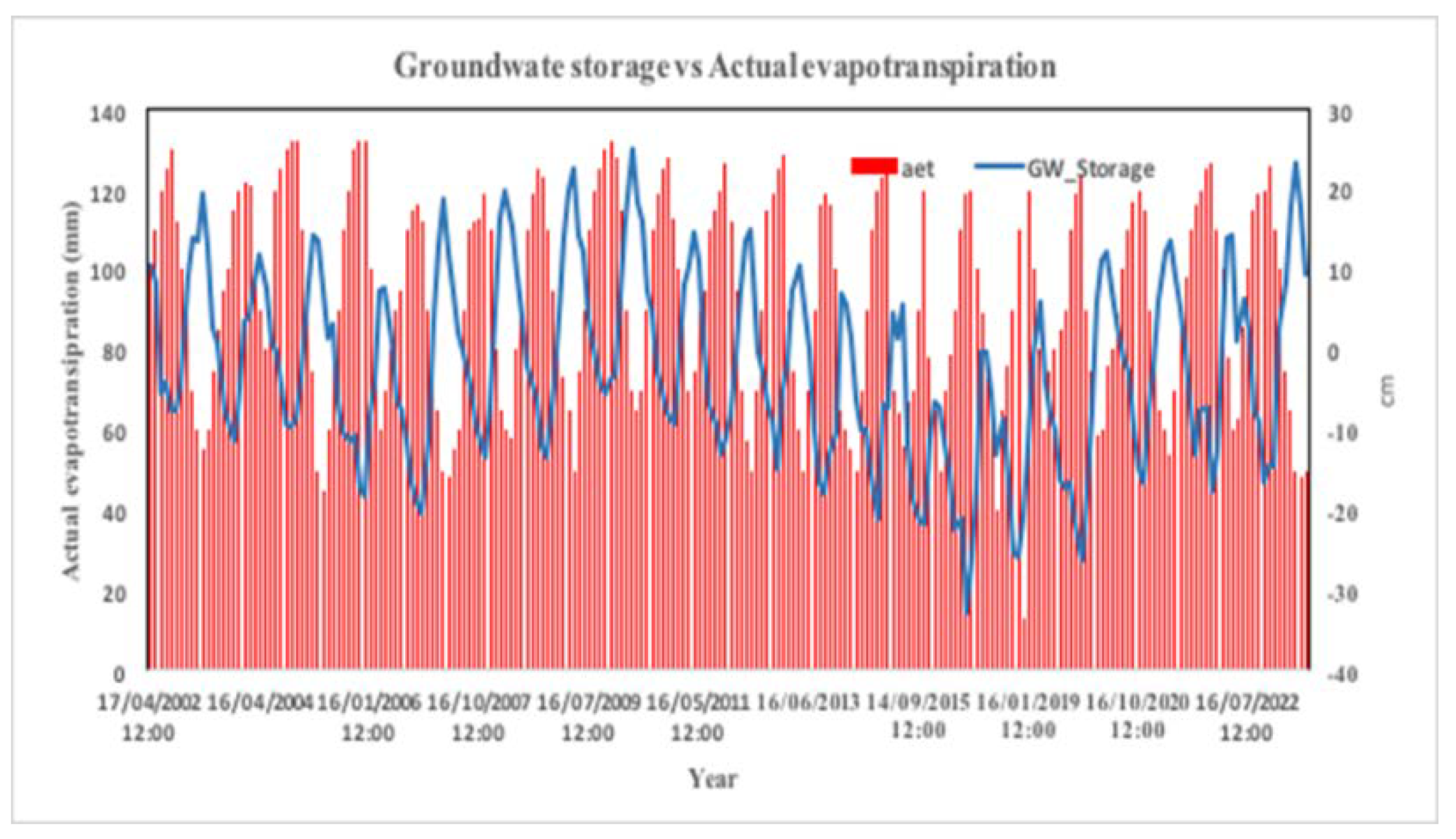
Figure 14.
Linear relation between TerraClimate srad and GRACE, GLDAS and GSWE GW depletion.
Disclaimer/Publisher’s Note: The statements, opinions and data contained in all publications are solely those of the individual author(s) and contributor(s) and not of MDPI and/or the editor(s). MDPI and/or the editor(s) disclaim responsibility for any injury to people or property resulting from any ideas, methods, instructions or products referred to in the content. |
© 2024 by the authors. Licensee MDPI, Basel, Switzerland. This article is an open access article distributed under the terms and conditions of the Creative Commons Attribution (CC BY) license (http://creativecommons.org/licenses/by/4.0/).
Copyright: This open access article is published under a Creative Commons CC BY 4.0 license, which permit the free download, distribution, and reuse, provided that the author and preprint are cited in any reuse.


