
Submitted:
03 June 2024
Posted:
04 June 2024
You are already at the latest version
Abstract
The open data market is growing, driven by laws requiring governments to make data publicly available. However, the true value of this market lies in the products and services derived from open data. In Slovenia, the open data market has been growing since 2015, especially in the field of mobility. Platforms such as Avtolog.si facilitate the retrieval of vehicle data via vehicle identification numbers, while tocen.si, ojpp.si, and brezavta.si aggregate mobility data, focusing on sustainable and micromobile public transportation services. These platforms use open government data and private sector open data, and are freely accessible. This study examines the use of open data in the Slovenian mobility applications and similar solutions developed in other countries. By mapping these applications, we gain valuable insights into potential advances in the field, and provide a useful resource for future developers worldwide. By focusing on the socio-economic impact of these innovations, the study identifies methods for evaluating such applications. This approach highlights how transforming open data into user-friendly products and services can deepen our understanding of their broader societal and economic benefits. While open data is valuable in its own right, its full transformative potential is realized through innovative products that support sustainable lifestyles and promote environmentally conscious behavior.
Keywords:
open data
; mobility applications
; sustainable services
; socio-economic impact
; big data
; real-time data
1. Introduction
Open data is generally defined as data that is publicly accessible and free to use. According to The Open Definition [1], to be truly open, data must be published under an open license that allows anyone to access, use, modify, and share it for any purpose. In addition, the data should be structured in a machine-readable and open format so that it has no restrictions and can be fully processed with a free software tool.
The open data market is constantly growing and various studies show that its value is rising steeply — not only in Europe, but all over the world [2,3]. In the European context, the availability of open data is strongly encouraged and there are regulations and directives in place to ensure the highest possible quality of data. Most European countries, as well as some major European cities, have their own national portals where they publish data from their public services (examples [4,5,6,7,8]). The official portal for European data [9] collects information from national portals and conducts research and comparative analysis. The value of the open data market in Europe was estimated at 184 billion euros in 2020 and is expected to reach between 199 and 334 billion euros by 2025 [2]. Open data includes not only open government data, but also open data from the private sector, and has even greater potential when combined with shared or personal data. It is worth noting that the value of data is not in the data itself, but in the value of the products, services, and content that open data enhances or enables. This reuse of data is encouraged not only in public services but also in private companies.
A study by Huyer and van Knippenberg suggested that the value of open data can be understood by examining the economic impact of its reuse. They propose a methodological approach to macro- and microeconomic estimates, with macroeconomic estimates involving quantitative analysis based on gross domestic product (GDP) estimates and microeconomic estimates providing quantitative analysis based on company- or individual-level data. The authors have adapted and applied the methodology to different areas — market size, job market, sectors, efficiency, costs saved, and organisations. Analysing available data and incorporating the results into services and products based on or enriched by open data can lead to indirect economic benefits, i.e. efficiency gains. The latter often also reflect societal benefits, for example when it comes to saving time on various tasks such as commuting via public transport or in traffic, saving lives, or helping the environment.
Open data on routes, departure times, delays and other relevant information can help to optimize public transport. By providing accurate and reliable real-time information through apps on personal devices, people can anticipate potential delays, adjust their route choices and optimize their travel time. For example, being informed of a delay before departure can reduce the actual waiting time for each train delay by an average of 2 minutes per person [2]. If all passengers in Europe used such apps, the researchers estimate that 27 million hours could be saved annually. This not only saves time, but also increases passenger satisfaction with public transport. Greater satisfaction can potentially increase people’s willingness to choose public transport over private transport and thus promote a more environmentally friendly alternative. Real-time information reduces both actual and perceived waiting times, which has a significant impact on overall satisfaction with public transport services [10].
The methodology of [2] was a basis for the study of the economic-social impact of open data in Slovenia by Likar and Štrukelj. The study revealed an estimated potential of 93 million euros for the size of the Slovenian open data market by 2025. In terms of efficiency in public transportation, it was estimated that providing real-time information about public transportation with open data-based apps can help save 97 thousand hours annually for all Slovenian train travelers. Based on the average labor costs per hour, open data can potentially save 1.85 million euros through time savings in public transport in Slovenia.
Slovenia has been actively working with open data since 2015 and, according to the Open Data Maturity (ODM) assessment in the context of the EU27, market maturity is continuously rated as above average. In addition to the quality of metadata, the ODM assessment also evaluates the level of national policies promoting open data, the features of national data portals, and initiatives to monitor the reuse and impact of open data [12].
Although some data are narrowly domain-specific, a significant part of open data has wide applicability in everyday life. However, the current form in which data is published often poses challenges for non-professional individuals. It may require prior computer knowledge for processing the data and may not be suitable for opening in freely available tools (e.g. due to the size of the CSV files). To address these challenges, efforts to improve the accessibility and usability of open data have led to the development of various applications that source data from open data portals and present it to users in a more user-friendly form.
1.1. Relevant Examples of Open Data Use
By 2021, the European Data Portal listed over 900 (re)use cases of open data, many of which are related to transportation and mobility, the primary focus of our work. Some of these projects offer integrated solutions that combine different modes of public transport for route planning and use open data to provide users with public transport schedules, delays, and real-time public transport tracking. Examples of multimodal transportation solutions include Res I Sthlm, Urbonaut, GetThere (Ireland), 9292 (Netherlands), Transport for Ireland and Transport for London. On the basis of OpenStreetMap, ÖPNV displays worldwide public transport facilities on a uniform map. Open data is also used in niche applications such as the monitoring of broken elevators (UpDownVienna, BrokenLifts in Berlin) and in a wide range of commercial services. Examples include Flixbus for bus route planning, Bolt for ride-sharing, delivery services, and micromobility, as well as Bird, Felyx, and Check for e-scooter and bike rental.
Multimodal planning, which encompasses various modes of transportation and mobility service providers, is also available in many other parts of the world, both through independent applications from tech giants and those developed by public service providers and national agencies. The largest commercial providers of multimodal route planning applications are Google and Citymapper. These applications enable navigation by public transport, car sharing, city bikes, and scooters in numerous cities around the world, and in some places taxi services are also integrated. However, these services are generally limited to larger cities where there is sufficient demand.
Google Maps [13] is a free mobile and web application that offers multimodal navigation worldwide. In cities with the best support, the application facilitates navigation on foot, by bicycle, car, public transportation, micromobility services, and ride-hailing services. Slovenia is among the less supported countries; the app offers navigation for walking, driving, and public transport, but the data for public transport is limited to the municipal services in Maribor and Ljubljana and the IJPP system.
Citymapper [14] is one of the most advanced applications for public transportation and micromobility services currently available. It offers better coverage than its competitors as it makes extensive use of data provided by users. The application integrates various transportation modes, allowing users to find the best possible routes in cities around the world, with a focus on Europe and the United States. In addition to public transportation, the app also incorporates private transportation modes, including taxis, Uber, Lyft, and rental services for bicycles and electric scooters. However, Citymapper is not available in Slovenia due to the smaller size of its largest cities and the resulting lower demand.
Another noteworthy project is Transitland [15], a community-edited open data service that aggregates transit networks across metropolitan and rural areas around the world. It collects over a thousand General Transit Feed Specification (GTFS) and GTFS Realtime (GTFS-RT) feeds from over 50 countries, usually in the form of a link to the latest version, which it periodically downloads and updates in its database. It also supports micromobility systems in the General Bikeshare Feed Specification (GBFS) format. Data sources are defined in JSON descriptive files stored on the GitHub platform and an API is provided for the user to explore and utilize the transit data. It can serve as a valuable resource for anyone interested in analyzing or visualizing public transit data on a global scale.
In recent years, numerous applications based on open data have also been developed in Slovenia. The European Data Portal and the Slovenian Open Data Portal list several of these applications, although some are no longer actively maintained or accessible to users. Among the more notable applications are:
- Covid-19 Tracker Slovenia1, which collects, analyzes, and publishes data on the spread of the coronavirus SARS-CoV-2 in Slovenia. Open data is validated and shaped into a format suitable for visualization to present to the public, as well as for further work in model development and forecasting.
- Parlameter2, which aims to create transparency by allowing organizations to analyze votes and transcripts of speeches from the National Assembly. It allows users to extrapolate voting results to monitor and compare voting behavior, share, embed, and quote speeches on the internet, follow and engage in live topic streams, and create automatic email notifications. Originally developed for the Slovenian National Assembly, this project has now been adapted for wider use and is available as a service in various environments. It is currently used in the National Assemblies of Croatia, Bosnia and Herzegovina, and Ukraine, as well as in four Slovenian municipalities: Ajdovščina, Hrastnik, Lendava, and Ljubljana.
- Environmental Atlas3, which is a map interface of Slovenia that presents data on various indicators measuring environment, climate, and land use. It includes information on water quality and flood risk areas, temperatures, sunshine, wind, and seismological risk areas. The map allows users to monitor environmental and meteorological indicators in a comprehensive overview. In addition to the current figures, users also have access to statistics that are useful for analytical purposes.
Some solutions for the use of open data on mobility and transport have also been implemented in Slovenia. In 2020, the Travana app for public transport in Ljubljana was released. Its main feature that set it apart from others (including the official Urbana app) was the display of bus locations in real time. The app quickly surpassed the official app in user ratings, with access to real-time location frequently mentioned in the positive comments. In 2023, both the Ljubljana and Maribor public transport companies added real-time tracking to their official apps.
M Mobilnost, the official app for public buses in Maribor, enables route planning and real-time tracking. However, the tracking feature is still in the beta phase and the app does not offer any additional services such as mobile ticket purchasing (which requires another app) or integration with other means of transport. In Ljubljana, the latest version of the official app has undergone a significant upgrade. It not only includes bus schedules and real-time tracking, but also enables payment and mobile ticket purchase for bike rides, provides information on the occupancy of BicikeLJ city bikes, parking garages and lots, news about detours and other related information, and integrates payment for on-street parking. The same Urbana city card can also be used as a library card.
Despite these recent advances, a notable gap remains in the field of multimodal transportation, as non-municipal companies offer similar services to the main systems in Ljubljana and Maribor.
1.2. Studies of Mobility Services
The development of information and communication technologies (ICT)-enabled web, mobile, and big data applications has fostered the creation of new mobility and transport services and systems [16].
Open data is essential for the development and optimization of these services. For example, a study on the state of open transportation data in Sweden [17] highlighted the potential to address strategic issues and foster new businesses. A study by Soriano García et al. also highlights the opportunity to take advantage of new technologies. The application of new technologies can help minimize the loss of time and energy, and improve the satisfaction of citizens. The use of open data already collected by public administration and private entities can benefit citizens by providing better services, public administrations by increasing transparency, and businesses by enabling the creation of value-added services and economic opportunities. Tsakalidis et al. propose that future transport and mobility services must be part of smart and sustainable city strategies to improve urban resource efficiency, promote decarbonization and ensure an integrated transport system. The EU-funded URBANITE project has developed a solution that collects and analyzes mobility and transportation data to assist public administrations in policy decisions on the urban transformation caused by new transportation and business models. New services improve the urban environment by optimizing the use of different mobility resources, thus promoting efficiency, sustainability, social equity, and quality of life [19].
However, the main problem remains the data formats, which are often not suitable or easily reusable [18]. This lack of standardization and interoperability among data systems makes it challenging to integrate and utilize data effectively across different platforms.
1.3. The Aim of Our Work
The aim of our work is to address the lack of comprehensive mobility applications in Slovenia and the low level of integration with most common global services. We therefore present the following applications based on Slovenian mobility data:
- Tocen.si is a multimodal transportation application aimed primarily at users in Ljubljana. It addresses the gaps in Google Maps coverage and the lack of Citymapper support by integrating the city’s official public transportation with various commercial services. Tocen.si summarizes all the important information and provides users with a comprehensive and convenient resource for navigating the city’s transportation. Two other related transportation applications in Slovenia are also breazvta.si and ojpp.si. Both are designed for the entire territory of Slovenia. While the first application combines public transport and sharing services (car, bike and scooter sharing), the second specializes in public bus transport. The aim of such initiatives is not only to participate in the development of open source solutions for access to public transport data and the integration of Slovenian data into existing solutions, but also to enable free access to public transport data for individuals and non-profit developers as well as for companies.
- Avtolog.si takes a novel approach to utilizing open data. Based on the Vehicle Identification Number (VIN), it provides users with comprehensive access to the history of a vehicle. The web application is designed for motorized vehicles registered in Slovenia, offering detailed information such as past ownership and maintenance records. By making this data easily accessible, Avtolog.si enhances transparency in the used vehicle market, helping buyers make informed decisions and promoting trust between sellers and buyers.
2. Materials and Methods
In developing models for public transport and mobility services data in Slovenia, the focus was on the following important steps:
- Dataset identification: Relevant datasets were identified to serve as the main source for the functionality of the application. As not all required datasets were publicly available, the service providers granted the developers access to their data upon request.
-
Comparison of the formats: To simplify data import, export, and integration with external tools, priority was given to the use of existing open standards. The most widely used standard for relevant information about transit systems is the General Transit Feed Specification (GTFS) [20]. GTFS was developed by Google in 2006 for Google Maps and is currently maintained by the non-profit organization MobilityData. Additionally, the system for intercity transport in Slovenia uses its own data model of the Integrated Public Passenger Transport (IJPP). Although the IJPP system can export data according to the GTFS standard, it lacks some essential information. A common language for shared mobility operators to exchange information about services is GBFS [21], developed by North American Bikeshare Association and also maintained by MobilityData.Public transportation and sharing services (car, bike and scooter sharing) were treated separately due to their different data requirements. This approach allowed the unique aspects of each service to be managed effectively.
-
Definition of common data models: A comprehensive data model for public transport was defined based on the GTFS and IJPP standards. The integration of information from all service providers, ensuring consistency and compatibility across different sources, was enabled by format adapters.In order to transfer the data into the system, a set of data conversion modules were developed to import data from the providers’ servers. An import module has been implemented for each of the data providers, which usually defines one or more periodic tasks that are automatically executed on the server.The update intervals depend on the type of data and the capacity of the source from which it is transferred. As the timetable data does not change often, the import of the timetables from the IJPP and LPP servers only takes place once a week, and Marprom sends the data manually, so there is no update interval. For real-time data transmission, the developers have opted for half the interval at which the data is updated on the providers’ side (i.e. 5 seconds for LPP). In addition to the GPS coordinates, the time of receipt of the position, the ID of the current journey and the direction of travel of the vehicle are stored. For sources that do not contain information on the direction of travel, this is calculated on the basis of the previously received position. As the data aggregator receives data from many different sources, duplicate data often occurs. The most common example is bus stops, which are used both in city bus networks and on intercity routes within the IJPP system. Since automatic grouping is not reliable and manual grouping is out of the question with such a large amount of data, the developers opted for a hybrid approach. They developed an interactive application in the Jupyter Notebook environment that calculates the distance between each pair of points in the database and displays each pair where the distance is below a certain threshold individually on the map and asks the user for a decision. If the user responds that the two stations are the same, their identifiers are written to the file and the next pair of stations is displayed. At the same time, the application saves a list of the stations already displayed in order to exclude them from the list the next time the program is started.
-
Design and development of the applications: MapLibre, MapTiler and OpenStreetMap were used to facilitate the visualization of real-time public transport tracking and the availability of car, bike, and scooter services. For public transport, it is also possible to view the published timetables for all city bus routes.As far as the technologies used are concerned, the apps are developed with different technologies. The tocen.si application was developed with the Flutter framework, which means that it is available on all mobile and desktop operating systems. However, for the same reason, it does not perform optimally on older or slower mobile devices. Both the backend and the frontend of the OJPP are developed in Django. Brezavta uses several advanced technologies to provide accurate and reliable services. It uses TransitClock, developed in Java, for arrival prediction, and OpenTripPlanner, written in Java, for data aggregation. The middleware API, which serves as an intermediary for retrieving data from different sources, was developed in Python using the FastAPI framework. The frontend of the application is currently being updated. The older version uses VanillaJS, while the new version will switch to React to improve usability and simplify maintenance and development of new features.
The pipeline for Avtolog.si was comparatively less complex as it relied on a single data source, so there was no need for format unification. All available vehicle data based on vehicle identification numbers (VINs) is collected by the Slovenian Open Data Portal [22]. When designing the application to present this data in a visually appealing and user-friendly format, the information that is most relevant to potential users (car owners and buyers) was selected, namely mileage and age of the owner, which are highlighted in the application, while the others are divided into four categories – vehicle information, technical inspections, information about the owner, and history. The frontend of the application was developed with React, which provides a dynamic and responsive user interface. The backend is powered by Django, a sophisticated Python-based web framework. For data storage and analysis, Avtolog uses Elasticsearch, a RESTful search and analytics engine, coupled with Kibana for data visualization.
3. Results
3.1. Multimodal Transportation Applications
3.1.1. The tocen.si Application
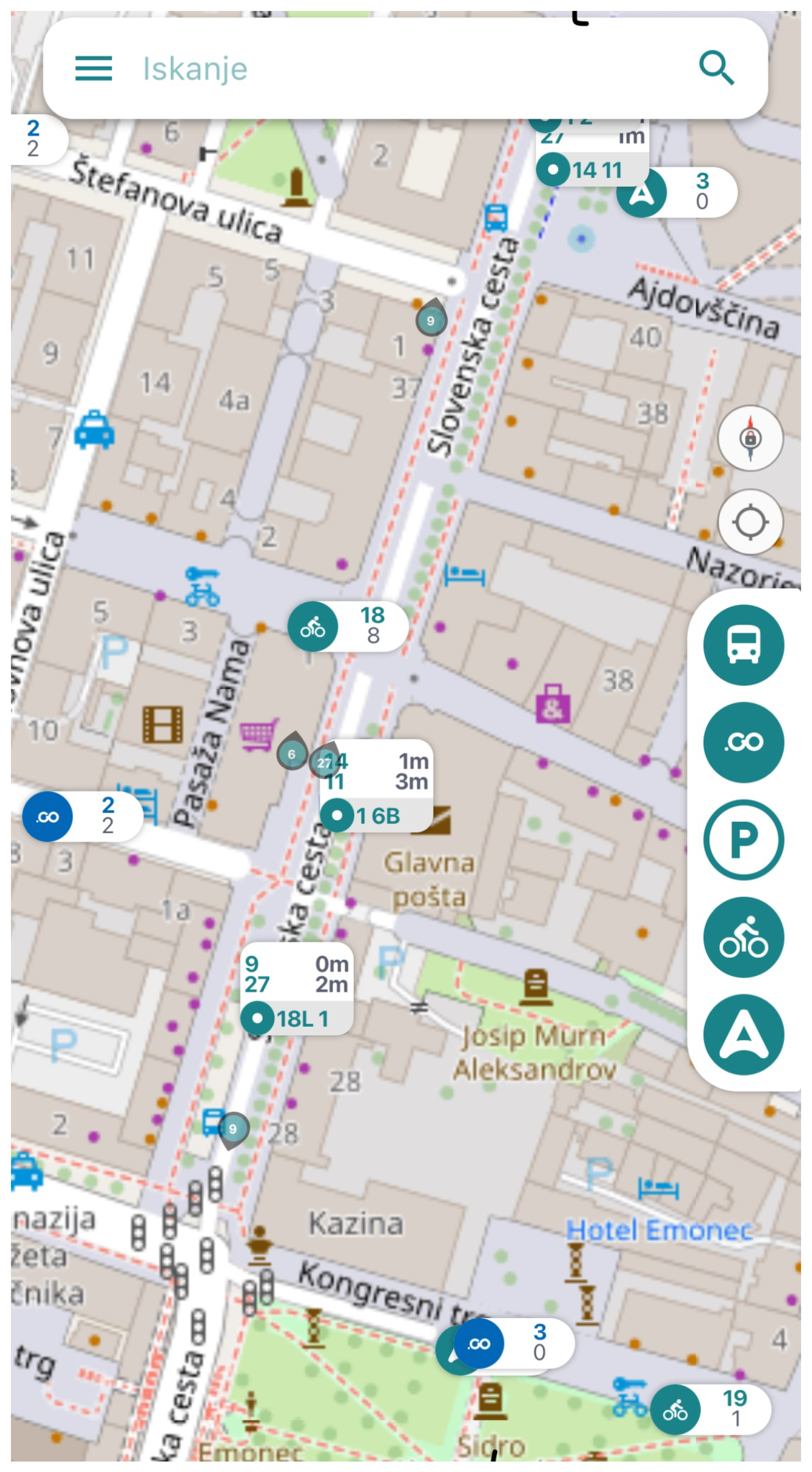
The application tocen.si4 is currently available as both a web and mobile app, featuring static and real-time data for the Ljubljana city bus network (LPP), the car sharing provider Avant2Go, parking lots in several Slovenian cities, and city bicycle systems such as BicikeLJ in Ljubljana, MBajk in Maribor, and Nomago Bikes throughout Slovenia. The main focus of the app is on sustainable and micromobile services that provide an environmentally friendly transportation solution. While route planning is not yet available, the app offers a dynamic, user-friendly interface (shown in Figure 1) with filtering services by transportation type or provider. Features include live updates of bus locations and schedules as well as availability displays for parking and sharing services. The app currently has over 2,400 users.
Figure 1.
Screenshot of tocen.si user interface of mobile application.
3.1.2. Mobility Map brezavta.si
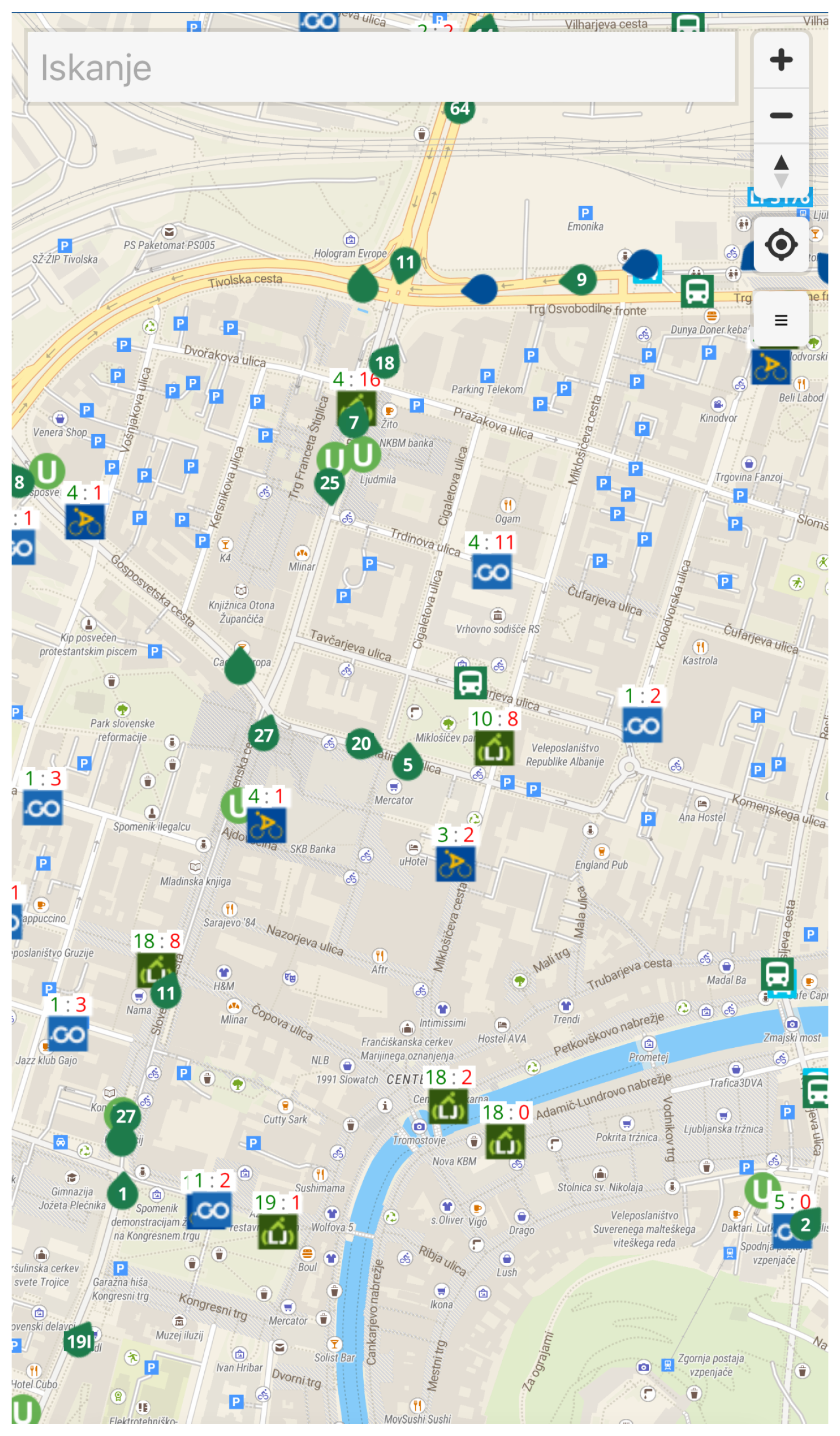
A comprehensive web application brezavta.si5 provides real-time information on various transportation services throughout Slovenia. It covers both city and intercity bus routes, displaying current location of each bus and plots the entire bus route when you click on a specific bus. It shows the estimated time of arrival at each stop. In Ljubljana and Maribor, the application shows real-time bus arrival times, while for other cities and intercity lines it shows scheduled times, where real-time is not available. The application also integrates the car sharing services AvantGo, GreenGO, and Share’N Go (the latter only available in Ljubljana). For each service, information such as location, model number or vehicle registration number, price per minute and kilometer, starting price, remaining battery range, remaining battery percentage, minimum rental price, and number of available vehicles and free parking spaces are displayed. In addition to buses and cars, brezavta.si also shows the current location of trains, including the name of the train and the line it is travelling on. For cyclists, it is integrated with various city bike sharing providers such as bicikeLJ in Ljubljana and Nomago Bikes in various Slovenian cities, and shows available bikes and parking spaces at each bike station. Finally, the application also displays the locations of the Urbanomats, the ticket and top-up machines for public transportation in Ljubljana. The different means of transport and providers can be filtered via the menu, as shown in Figure 2, allowing the user to customise the application to their needs.
Figure 2.
Transportation mode filter menu.
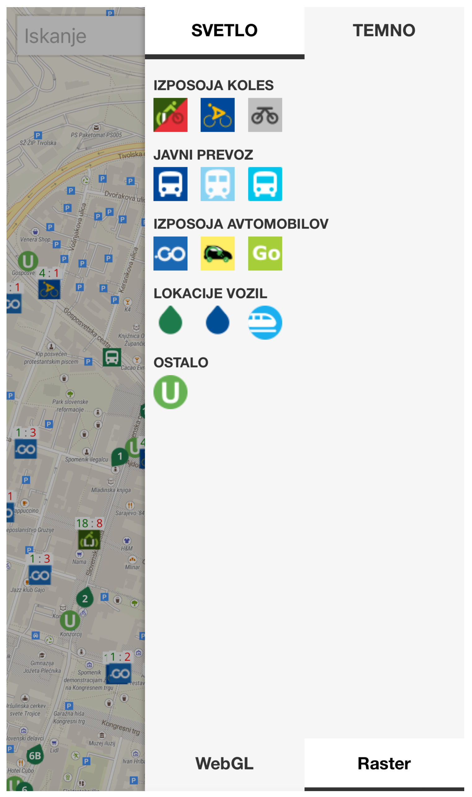
Figure 3.
The brezavta.si user interface.
3.1.3. Open Public Transport Platform
Figure 4.
ojpp.si map view
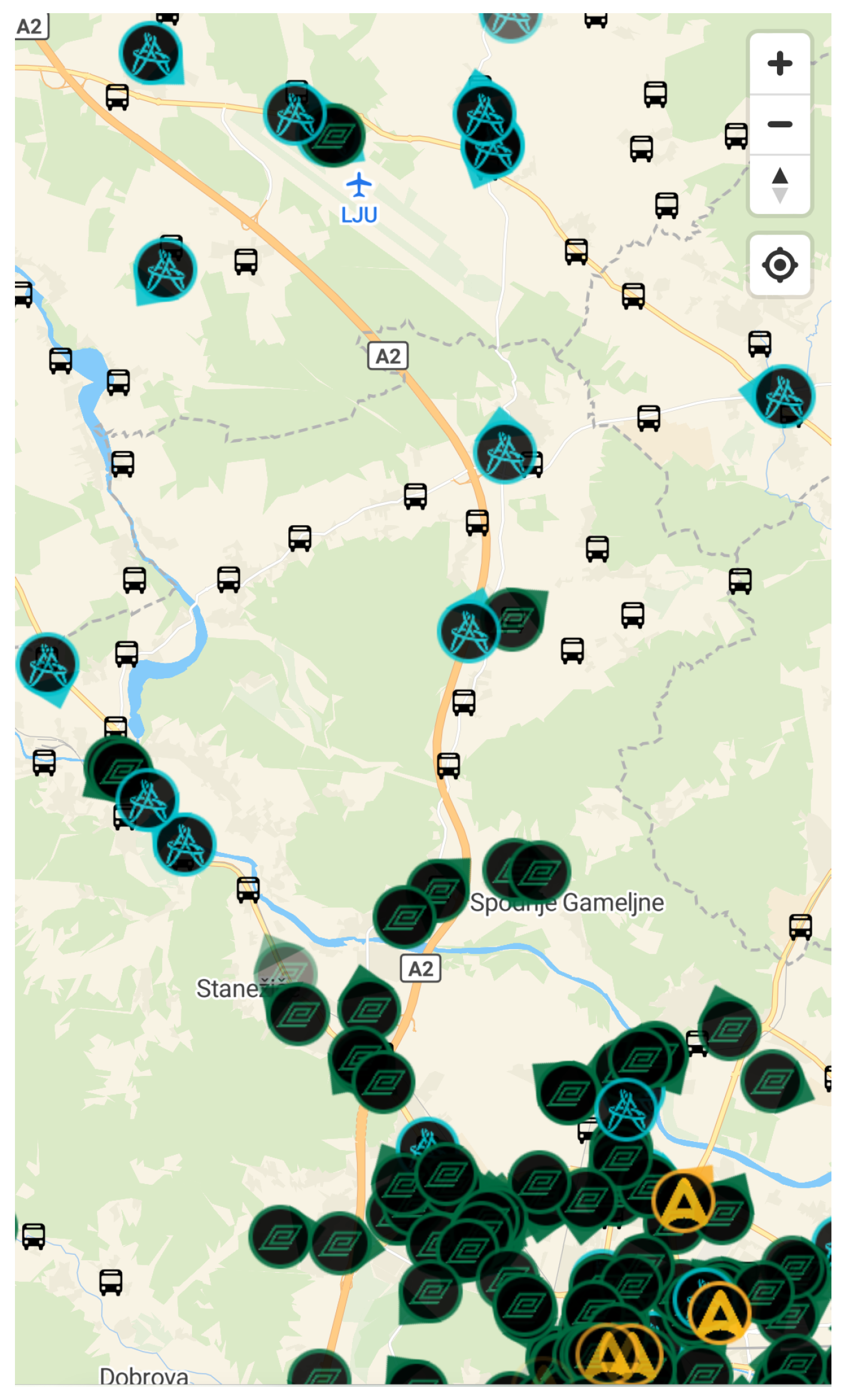
Figure 5.
ojpp.si vehicle information
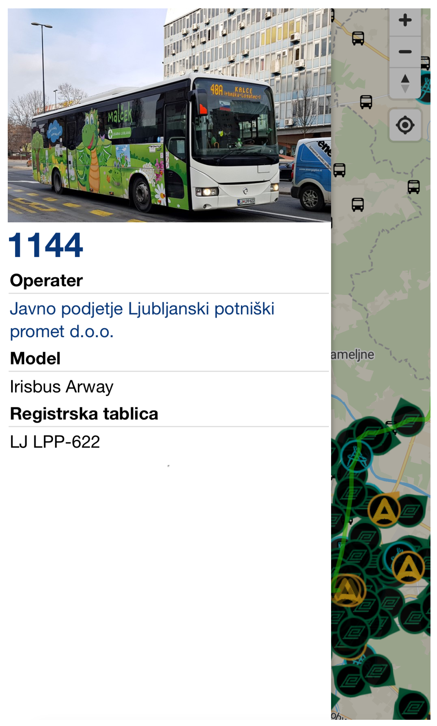
The OJPP (Open Public Transport Platform)6 specialises in city and intercity bus transportation covering the entire country. It offers comprehensive coverage of all bus stations and bus locations. Users can easily access detailed information about each station and track the whereabouts of buses in real time. By clicking on a specific bus, users can see the entire route of the line, except for city routes. In addition to the map view, the platform provides open-access data collections, including a list of operators with the number of vehicles and routes for each operator, 53 operators in total. Each vehicle is assigned a unique ID and each trip is linked to a trip instance, which is linked to a timetable. In addition, the platform lists all stations and provides users with a complete overview of the bus transportation network. An important addition to the platform is the availability of machine-readable data via an API, which enables developers to integrate the platform’s comprehensive transportation data into their own applications and services.
3.2. Vehicle Data Retrieval Application Avtolog
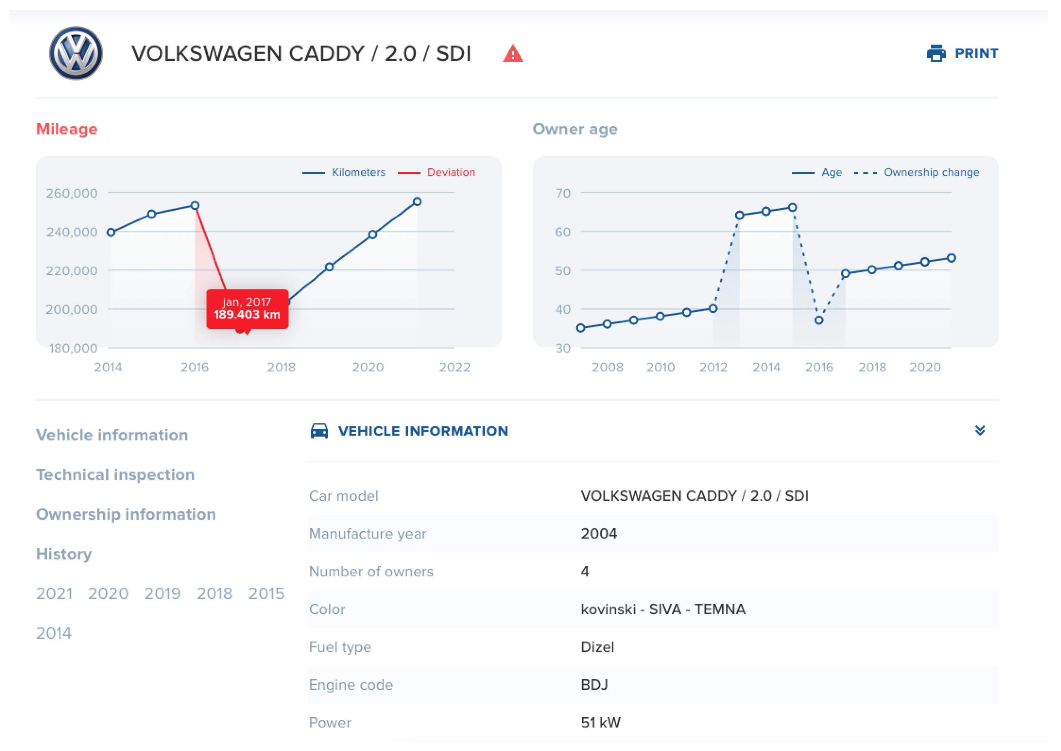
The Avtolog7 online service is available as a web app and mobile app. It allows users to search for data on all vehicles registered in Slovenia using the vehicle identification number and provides insight into various vehicle details such as make and model, year of manufacture, likely number of vehicle owners (based on yearly changes in the year of birth and/or place of residence), date of first registration, gender and age of the owner, and other technical data, such as homologation. The app offers a historical overview of roadworthiness test performances, including all MOT measurement values. Users can check the accuracy of the mileage displayed and ensure that all retrofits are properly registered in the vehicle type approval. Avtolog presents the vehicles through visualizations that show the evolution of the mileage over time as shown in Figure 6, making it particularly valuable for pre-owned vehicle buyers.
In the latest updates to the app, several new features have been introduced to improve usability and convenience. The app now supports searching by scanning a vehicle license with automatic VIN recognition to quickly retrieve data. Users can also register their phone number in the app to save vehicles in a personal collection called My Garage, which allows easy access to stored vehicle information. They can also report incorrect vehicle data directly through the app, contributing to the accuracy and reliability of the information provided, or automatically generate and print a sales contract for the selected vehicle.
The web app was publicly launched in January 2019 and has since attracted over 35,000 unique monthly visitors, as well as over 4,000 active mobile devices on iOS and Android platforms. It has already helped many to detect and address fraudulent activities, such as odometer manipulation. Users have even reported successfully resolved claims against car dealerships that had sold vehicles with tampered odometers. This proves the effectiveness of the service in achieving its goal of promoting transparency and reliability in the used car market.
Figure 6.
Example of an Avtolog report. The change in the mileage in 2017 could indicate a manipulation of the odometer. The odometer change also correlates with owner change in 2018.
Figure 6.
Example of an Avtolog report. The change in the mileage in 2017 could indicate a manipulation of the odometer. The odometer change also correlates with owner change in 2018.
4. Discussion
The applications have overcome various challenges in combining different formats of multiple data collections and helped to close the gap in the reuse of mobility and transportation data in Slovenia. Their primary advantage is that they are free to use and some even offer APIs that support developers in creating new solutions. The multimodal transportation applications offer several advantages that improve the user experience and promote sustainable urban mobility. Features such as customizable filters ensure a personalized and efficient experience. Real-time public transport tracking provides live updates on bus locations and timetables, allowing passengers to plan their journeys accurately and avoid unnecessary waiting times. Future developments could include the integration of comprehensive route planning features, allowing users to plan journeys using all or selected modes of transport. The Breazavta app is already in beta testing for this feature. In addition, there are plans to introduce a sustainability calculator that will calculate the carbon footprint saved by choosing sustainable transportation options. This feature could encourage users to make more environmentally conscious decisions by visualizing their positive impact on the environment.
The Avtolog application increases transparency in the used vehicle market by linking national vehicle registration data with technical inspection data, thus increasing safety, also at European level. The application supports informed decision-making when buying a pre-owned vehicle by providing detailed information on the safety and technical condition of vehicles. By allowing users to search for information on individual vehicles, it helps them to become better informed and reduce the risk of fraud. When transferring ownership of a used car, the condition of the vehicle is crucial to the current price and future investment. The depreciation of a vehicle is mostly based on the kilometers driven, and the average mileage varies greatly depending on the form of ownership, location and intended use (leasing or ownership, Slovenia or abroad, private or business use). Therefore, the number of kilometers driven is an important factor that future owners consider when purchasing a vehicle. The most common cases of fraud include manipulated odometers, the installation of non-homologated parts, and deception regarding use and ownership. In addition, the app highlights environmental and safety aspects, such as the number of vehicles with different drive types and the EURO standards of petrol and diesel engines. By providing comprehensive data on pollutant emissions and EURO standards, the app raises users’ awareness of environmental impacts. Possible future enhancements to Avtolog include the systematic addition of new sources to the database in order to obtain additional vehicle information. For example, a connection could be established with the database of stolen vehicles and information on the payment of road tax could be included. Cooperation with neighboring countries would also enable a comprehensive check of the history of imported vehicles and address the common problem of odometer tampering. A notable limitation to data collection is the current legislation, which does not require the first mandatory technical inspection until four years after the vehicle is first registered. As current legislation does not regulate the inspection or recording of the condition of newer vehicles, this should also be taken into account. Systematically recording the mileage at each vehicle service and reducing the time interval for reporting the data from one year to one month could provide users with more accurate and up-to-date data. The application could also be enhanced by including other existing information, such as reasons for technical inspection failures, which could improve the accuracy and scope of the application.
Overall, future work on such applications should also focus on calculating their socio-economic impact. By collecting and analyzing real-world usage data, information on delays, trends in vehicle history and other relevant statistics, researchers can go beyond speculative estimates and make more accurate and realistic assessments. For example, time savings from the introduction of real-time public transportation apps can be more accurately estimated by examining data on current delays and user behavior. Other benefits could also be identified, such as less traffic congestion, lower emissions, and better air quality through the optimized use of public transport or bike sharing services. In addition, by analyzing trends in vehicle data, we can examine potential impacts on the used car market. If vehicle data is made openly available in a user-friendly format, this could lead to less odometer tampering. If trends in newer entries show less tampering, this suggests that open data can improve market transparency. This approach not only helps to demonstrate the immediate benefits, but also supports long-term planning and policy making to maximize both economic and social benefits.
5. Conclusions
We have presented applications that exemplify best practices in the use of open data for mobility and transportation in Slovenia. While public and multimodal transport services are developed and widely used in other European cities, the Slovenian public transport network was not significantly considered before the development of these applications. In addition, integration with commercial services such as car sharing makes sustainable transportation options even more accessible to users. A notable example of the use of open data is also a free service for vehicle history report, all based on vehicle identification number. This application is a valuable tool for all drivers, especially those considering purchasing a used car. The paper also discusses strategies for dealing with the challenges associated with large and diverse datasets and provides useful advice for developers facing similar problems. Such projects demonstrate the successful application of big data collections to simplify and enhance people’s lives. They show the potential for future projects in other countries to use open data for the benefit of the general public.
Author Contributions
Conceptualization, K.Ž. and M.P.; methodology, K.Ž and M.M.; software, V.K., A.J. and M.P.; validation, M.M.; formal analysis, K.Ž., M.M. and M.P.; data curation, K.Ž., M.M. and M.P.; writing—original draft preparation, K.Ž.; writing—review and editing, M.P. and M.M.; project administration, M.P. and M.M.; funding acquisition, M.M. All authors have read and agreed to the published version of the manuscript.
Funding
The authors acknowledge the financial support from the state budget by the Slovenian Research and Innovation Agency (project No. V2-2388).
Conflicts of Interest
The authors declare no conflicts of interest. The funders had no role in the writing of the manuscript.
References
- Open Knowledge. The Open Definition - Version 2.1. https://opendefinition.org/od/2.1/en/, 2015.
- Huyer, E.; van Knippenberg, L. The economic impact of open data: opportunities for value creation in Europe; Publications Office of the European Union, 2020. [CrossRef]
- Manyika, J.; Chui, M.; Farrell, D.; Kuiken, S.; Groves, P.; Doshi, E. Open data: Unlocking innovation and performance with liquid information, 2013.
- Plateforme ouverte des données publiques françaises. https://www.data.gouv.fr/fr/. Accessed: 15. 5.2024.
- Paris|Data. https://opendata.paris.fr/pages/home/. Accessed: 15. 5.2024.
- I dati aperti della pubblica amministrazione. https://www.dati.gov.it. Accessed: 15. 5.2024.
- Il portale degli Open Data della Regione Piemonte. https://www.dati.piemonte.it/#/home. Accessed: 15. 5.2024.
- Odprti podatki Slovenije. https://podatki.gov.si. Accessed: 15. 5.2024.
- The official portal for European data. https://data.europa.eu/en. Accessed: 15. 5.2024.
- Brakewood, C.; Watkins, K. A literature review of the passenger benefits of real-time transit information. Transport Reviews 2019, 39, 327–356. [Google Scholar] [CrossRef]
- Likar, B.; Štrukelj, P. Report on the economic-social impact of open data in Slovenia. https://podatki.gov.si/sites/default/files/reports/Economic-social%20impact%20of%20open%20data%20in%20Slovenia.pdf, 2021. Accessed: 29. 05. 2024.
- Page, M.; Hajduk, E.; Lincklaen Arriëns, E.; Cecconi, G.; Brinkhuis, S. Open data maturity report 2023; Publications Office of the European Union, 2023. [CrossRef]
- Google Maps. https://maps.google.com. Accessed: 21. 5.2024.
- Citymapper - The Ultimate Transport App. https://citymapper.com. Accessed: 21. 5.2024.
- Transitland. https://www.transit.land. Accessed: 21. 5.2024.
- Tsakalidis, A.; Balen, M.; Gkoumas, K.; Haq, G.; Ortega Hortelano, A.; Grosso, M.; Pekár, F. Research and innovation in smart mobility and services in Europe – An assessment based on the Transport Research and Innovation Monitoring and Information System (TRIMIS); Publications Office of the European Union, 2020. [CrossRef]
- Jönsson, J.; Shamoon, S. Road traffic open data in Sweden: Availability and commercial exploitation - A research study on the state of open transportation data in Sweden, 2022.
- Soriano García, F.; Samper Zapater, J.J.; Martinez-Durá, J.; Cirilo Gimeno, R.; Plumé, J. Smart Mobility Trends: Open Data and Other Tools. IEEE Intelligent Transportation Systems Magazine 2018, 10. [Google Scholar] [CrossRef]
- Urbanite Project. https://urbanite-project.eu/. Accessed: 22. 5. 2024.
- MobilityData. General Transit Feed Specification (GTFS). https://gtfs.org. Accessed: 2024-05-22.
- MobilityData. General Bikeshare Feed Specification (GBFS). https://gbfs.org. Accessed: 2024-05-22.
- Ministrstvo za infrastrukturo. Rezultati tehničnih pregledov motornih vozil. https://podatki.gov.si/dataset/rezultati-tehnicnih-pregledov-motornih-vozil, 2024. Accessed: 27. 5. 2024.
| 1 | |
| 2 | |
| 3 | |
| 4 | |
| 5 | |
| 6 | |
| 7 |
Disclaimer/Publisher’s Note: The statements, opinions and data contained in all publications are solely those of the individual author(s) and contributor(s) and not of MDPI and/or the editor(s). MDPI and/or the editor(s) disclaim responsibility for any injury to people or property resulting from any ideas, methods, instructions or products referred to in the content. |
© 2024 by the authors. Licensee MDPI, Basel, Switzerland. This article is an open access article distributed under the terms and conditions of the Creative Commons Attribution (CC BY) license (https://creativecommons.org/licenses/by/4.0/).
Copyright: This open access article is published under a Creative Commons CC BY 4.0 license, which permit the free download, distribution, and reuse, provided that the author and preprint are cited in any reuse.


