Submitted:
16 May 2024
Posted:
16 May 2024
You are already at the latest version
Abstract
Climate change-induced Sea level rise, shoreline changes, and coastal erosion are projected to drive massive population displacement and mobility in Africa. This study was conducted to examine the pattern of shoreline changes, coastal erosion, land use/Land cover dynamics their projections, and its implications on internal migration in Senegal, Kenya and Tanzania representing West and East Africa. The digitized shoreline was mapped into both erosion, accretion and trend analysis which further explains the vulnerability and physical processes that could trigger human displacement within the context of environmental/climate migration. Analysis of landuse and land cover dynamics was obtained from Landsat 5 TM of 1986, Landsat 7 ET of 2006, Landsat 8 OLI/TIRS of 2016 and Landsat 9 OLI/TIRS 2022 and computed using ArcGIS 10.7 for Land-use change and percentage change in square kilometers was conducted to examine landuse/landcover dynamics and their contributions to the risk of coastal erosion in the study regions. The outcome of the shoreline analysis reveals that 972.03sqkm of land has been lost to coastal erosion in Senegal from 1986-2022 with 2016-2022 described as the period with the highest in terms of land loss. In Kenya, -463.30sqkm of land has also been lost to coastal erosion and agents of wave processes with 1986-2006 recording the highest share of -87.74% loss of valuable land while In Tanzania, -1033.35sqkm of valuable land has been lost from 1986-2022 to coastal erosion with 2006-2016 alone recording -10.4634% of land loss. The result of the land use/land cover percentage change analysis indicates a massive loss of vegetation cover with a significant increase in settlement representing urbanization. The scenario modeling of the shoreline on 10,20 and 30ms indicates that 567 persons per sq, 25904.5 persons per sqm and 25904.5 persons per sq km for both 20 and 30ms will be displaced in Senegal while in Kenya 577.5 persons per sq km will be displaced at 10m followed by 1210.3 persons per sq km at 20m and 7737.3 sq km at 30m. In, Tanzania, 702001.9 persons per sq km are projected to be displaced at 10m shift in the shoreline. Structured Questionnaires were administered to elicit responses from coastal dwellers on their perception of coastal erosion and environmental migration as part of ground truthing and the result of the survey affirms that coastal erosion and its exposure are the major drivers of environmental migration in the study area.
Keywords:
Sea level rise
; Shoreline changes
; coastal erosion
; Land use/Land cover dynamics
; population displacement
; climate migration
; climate adaptation
; West and East Africa
1. Introduction
The shoreline, which also goes by the name of coastline, represents the area where land terminates, and the occurrences of sea and ocean begin. It could either be a sandy beach or a rocky line (Misra and Balaji, 2015). Beach foreshore is a dynamic medium and it can either proceed at a slow rate or with a quick pace towards inland or the sea (Samanta & Paul 2016).
Coastlines worldwide are influenced by various coastal processes, including slope, tidal fluctuations, sediment characteristics, wave dynamics, nearshore circulation, and sea level rise (Atayi et al., 2022). Littoral transport, responsible for material removal and tidal processes, also plays a significant role. Shoreline and coastline stability is a worldwide threat that emerges because the mean sea levels rose by 11-16cm in the last century and thus the coastal eroding became worse (Schwartz, 2005; Islam, et. al., 2023). There exist lots of countries with coastline, particularly in Africa, that are vulnerable to the sea level rise and the number of people who live in the densely populated coastal cities tends to increase every election (Nicholls et al., 2008; UN-HABITAT, 2008). Studies of late sea-level rise in Eastern Africa and in the Indian Ocean by Mafaranga (2020) and Sally, Maere, and Nicholls (2010) show rates of up to 5mm per year. These pinpoint the harmful consequences including the economic dimension through increased shoreline erosion as well as the degraded water quality which leads to waterborne diseases (Mafaranga, 2020).
The direct impacts of sea-level rise include inundation of low-lying areas, shoreline erosion, coastal wetland loss, saltwater intrusion, higher water tables, and higher extreme water levels leading to coastal flooding (Sally, Kebede and Nicholls, 2010).
A recent study conducted by (Nguyen and Takewaka, 2020) on Sea level rise affirmed that SLR accounts for 66% of the observed rate of erosion in Vulnerable regions thereby resulting in the inundation of low-lying areas, impacting at least 100 million persons globally who live within 1 m of mean sea level (Zhang et al., 2004). Aside from the physical and natural causes of shoreline changes, human disturbances such as damming, dredging, mining, and urbanization which are impacting water resources are responsible for the erosion and accretion rates of shorelines greatly (Pandian et al., 2004). The problem of coastal erosion is common today and results in big economic and environmental losses: for instance, a change in ecosystems occurs due to a sitting of new coastlines (Woodroffe et al., 2006; Mentaschi et al., 2018).
The causative mechanism of coastal erosion includes strong wave action, upstream discharge, river bathymetry, global warming, and sea level rise. Furthermore, Soil properties such as texture and structure govern pore size distribution and exert enormous influence on soil loss due to erosion. Studies suggest that soil moisture has a substantial influence on water runoff and soil erosion (Wei et al., 2007; Lal et al. The increase of such activities along the coast leads to an economic boost while at the same time increasing the risks of hazardous events such as storm surges, flooding, salinization, and fish decline which devastate the social and economic well-being. An illustrative example, Senegal bears the most significant difficulties because of coastal deterioration, with the tourism industry being the most affected as outlined by the World Bank report in 2019 and also the findings of the study carried out by Taveneau et al. (2021).
In addressing the planning challenges associated with coastal regions for sustainable development, land use/Land cover studies have emerged as an index for proper quantification of different types of land loss due to coastal erosion which is crucial for a better understanding of the impacts of shoreline change. ). Land cover change has also been described as the most significant regional anthropogenic disturbance to the environment. In essence, both land use and land cover changes are products of prevailing interacting natural and anthropogenic processes by human activities (the use to which land is being put). Land use and cover
In West Africa, coastal areas are home to 31% of the population and provides 56% of the sub change and land degradation are therefore driven by the same sets of proximate and underlying factors elements. Land use and cover change is therefore central to environmental processes (Ideki, 2022). It is particularly important for proper planning and implementation of appropriate environmental practices. Land use and land cover analysis using satellite imagery is a cost-effective way to monitor long-term changes. Many different methods are used to classify land use and land cover. The maximum likelihood, random forest, support vector machine, and artificial neural network methods were found to be most applied method for LULC analysis (Otukei and Blaschke, 2010; Rodriguez-Galiano et al., 2012; Balha and Singh, 2022). It is evident that in recent decades, human activity has significantly influenced land use and land cover globally (Lambin and Geist, 2008). region’s GDP (The world bank, 2020). As a result, it is expected that the coastal ecosystem will experience changes due to the huge number of human footprints in the coastal regions. Given the menace loss or gain of land resources due to erosion/accretion processes that characterized Senegal, Kanya and Tanzania coast, it has become impetrative to map existing land use and land cover (LULC) and to integrate resulting data products with information on future shoreline change.
Coastal land loss due to sea level rise, shoreline changes, and coastal erosion has the potential to influence the migration decisions of the people living in coastal African regions in search of prosperous livelihoods (Call et al., 2017). According to the International Office for Migration (IOM,2022), Environmental Migration refers to people who are forced to leave their homes due to sudden environmental changes internally or abroad. Climate-induced migration has increased despite Covid-19 lockdowns with 14.6m people displaced due to slow onset events. (IOM Ibid). Migration and climate change are now at the front burner of international discourse given the intensification of slow-onset climate events. The nexus between climate change and migration is complex. Migration can also be described as a highly personal decision that people arrive at after consideration of a wide range of factors such as economic, environmental, demographic, social, and political factors. Migration itself represents a critical resilience approach against the deleterious impact of climate change. However, most studies have focused on migration from the perspective of a failure to adapt to climate change while others viewed it as an adaptation strategy itself (Mbiyozo,2020)
In a recent publication released by (IOM, 2022), migration driven by climate and weather-related hazards was revealed to have reached unprecedented levels with 24.5 million persons internally displaced attributed to climate-related disasters. The report further added that the intensity and frequency of hazards that trigger human displacement are on the increase thereby threatening increasing livelihoods and ecosystems, exacerbating existing vulnerabilities. and undermining resilience. Relatedly, another study projects that by 2050, West Africa alone could record 32 million while the total number of environmental migrants from the rest of the continent could reach 86 million if no concrete and proactive action is taken (Rigaud, et al.2021a). In terms of countries with the highest projected number of internal migrations from climate-related hazards, Senegal ranks the highest in West Africa with 1 million followed by Niger and Cape Verde of 30.26 and 6.02 % respectively. Others are São Tomé and Príncipe (0.09 percent) and Guinea (0.27 percent) respectively. The contributory factors to Senegal's vulnerability to environmental migration emanate mainly from increased exposure to sea level rise, high rate of coastal erosion along the coast, and climate extremes such as drought and floods (World Bank Groundswell Report,2021). Senegal in West Africa remains a casualty of coastal erosion as notable towns and cities are on the verge of inundation by ravaging seawater. In terms of actual economic loss, the country lost half a billion US dollars to the menace of sea level rise and coastal erosion (World Bank 2019). A larger chunk of these losses is from the tourism sub-sector, where the sector has recorded a consistent decline in patronage due to eroding and disappearing beaches and encroachment of structures. Coastal erosion could affect revenue projections of the tourism sector and ultimately disrupt GDP growth especially as the sector is one of the fulcrum of Senegal’s economic growth plan (Taveneau et al, 2021)
In Kenya, the coastal city of Mombasa is particularly exposed to coastal erosion and sea level rise, with an estimated area of 4-6 km2 at the risk of being submerged with a rise in sea level of only 0.3 meters. Furthermore, tourism shipping, and the agricultural sectors which constitute 95% of the coastal economy have continued to experience a decline in revenue projection as a result of coastal erosion (Awuor et al,2008, (Omuombo et al, 2013). In Tanzania, climate change and rising sea level projection of 1.5 and 3 feet by 2050 could see over 5 million residents of the city and millions of people in other parts of Tanzania residing in the coastal areas at risk of being displaced if the government fails to address the twin problem (Nicholls, R.S; Kebede, A.S and Brown, S (2010) ). Ndubi et al, 2015 and the World Bank,2019 report that coastal erosion and flooding are the main drivers of environmental degradation and account for more than 60% of total economic loss in West Africa. A separate study by Luijendijk (2018) on the state of the world beaches reported that 24% of the world's sandy beaches are eroding at rates exceeding 0.5m/year while 28% are accreting and 48% are eroding at high rates and concluded that majority of the shorelines in coastal areas are eroding thereby raising serious concerns.
There is every reason to see the menace of shoreline changes, coastal erosion, land use/land cover changes, and the propensity for people to migrate as a problem in Senegal, Kenya, and Tanzania that needs to be accorded research attention.
Taking into consideration the identified gaps in the literature and the resultant failure of previous studies, to investigate comprehensively the link between shoreline changes, and coastal erosion, land use/land cover changes across regional lines, it has therefore become essential to conduct a comparative analysis of shoreline changes, coastal erosion, land use /land cover dynamics and their implication on human mobility in West and East Africa using GIS/Remote sensing techniques. The research is therefore innovative and presents a bold attempt to examine drivers of coastal processes such as shoreline changes, and coastal erosion and their on-climate migration with perspectives from East and West African sub-regions and this is the relevance of the study. Consequently, the study is anchored on the following objectives.
1. Analysing, mapping, and capturing the coastal changes along Senegal, Kenya, and Tanzania coastlines.
2. Assessing land use/load cover changes in the study area.
3. Performing shoreline and land use/land cover modeling, and analysis of its effect on population and climate migration of these countries namely Senegal, Kenya, and Tanzania.
4. Looking into adaptation and coping mechanisms of residents who are at risk of population movement because of environmental change.
2. Materials and Methods
2.1. The Study Area
Senegal is a coastal West African country located in latitude 14oN of the equator and 14O of the prime meridian bordering Mauritania in the North, Mali in the East, Guinea and Guinea Bissau in the South and the Atlantic Ocean in the West. Senegal occupies a surface area of 197.712km2 out of which 192,00km is land and 4,190km is water where the Gambia forms an enclave within Senegal (Faye, et al, 2021). Tanzania located on Lat 6oS and 35oN has long stretch of coastline put at about 1,424km of mainland coastline and several islets including major and inhabited islands of Zanzibar to the northeast and Mafia in the south (Nwakumanya,2021) while Kenya is located on latitudes 100oN and 38oE in East Africa bordering South Sudan in the Northwest, Somalia to the East, Tanzania to the south and Ethiopia to the North (Nyandwi,2010)
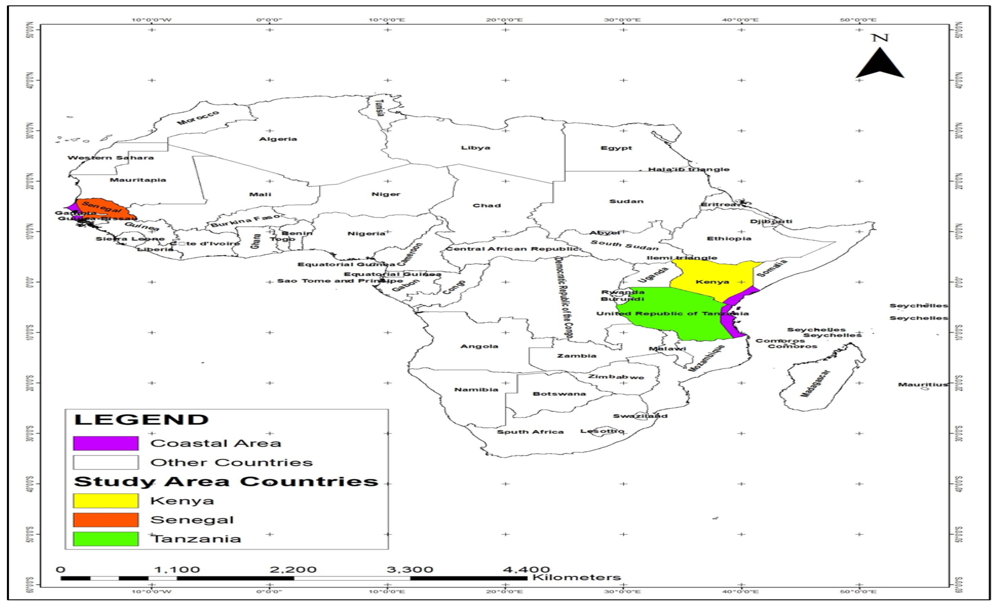
Figure 1.
Map of Africa showing the study area: Senegal, Kenya and Tanzania.
2.2. Data Collection and Analysis:
The data set used for the study was obtained from secondary sources. The shorelines were directly digitized from the Google search engine through the historical settings of 1986, 2006, 2016, and the current year of 2022. The climate data were obtained from the https://gis.ucar.edu/gis-climatedata website which covers the entire Africa. The land use and land cover maps were obtained from the landsat imageries downloaded from the Earth Explorer of the United States Geological Survey (https://earthexplorer.usgs.gov The Gridded Population of the World of 2020 was downloaded from https://sedac.ciesin.columbia.edu/data/set/gpw-v4-population-density-rev11 for the population density (number of persons per square kilometer). This was projected for 2022 in ArcGIS 10.7. The shorelines of different periods of the study were captured from the Google search engine through the historical settings of 1986, 2006, 2016, and the current year of 2022.
2.3. Image Geo-Processing for Landuse Change and Percentage Change
The study made use of multi-spectral satellite images of Landsat 5 TM of 1986, Landsat 7 ETM of 2006, Landsat 8 OLI/TIRS of 2016 and Landsat 9 OLI/TIRS 2022 for the landuse/land cover analysis. All the imageries were of 30m spatial resolution and cloud free. Other information of the imageries are found in Table 1. The bands of each scene were stacked together using COMPOSITE module of the ArcGIS 10.7. Thereafter, the staked layers were mosaicked to cover the entire study area. The landuse/land cover classification in Senegal, Kenya and Tanzania was guided by the information obtained from West Africa: Land Use and Land Cover Dynamics and available at https://eros.usgs.gov/westafrica/data-downloads. The percentage change was computed using equation (1) below
Where,
d is the difference in the value of area covered by a land cover category at the initial time point and final time point
t1 is the value of the area covered by a land cover category in the initial time point
y1 and y2 are base year and final year respectively.
2.4. Shoreline Analysis
The digitized shoreline was analyzed into both erosion and accretion. The trend was arithmetically obtained by subtracting the erosion value from the accretion value. The percentage change of the trend was also calculated.
2.5. Method of Data Analysis
The study employed the use of descriptive statistics involving the use of spatial extent in terms of landuse/land cover analysis, minimum, maximum, and mean in terms of climate data and population density data; and spatial coverage in terms of shoreline changes. Zonal statistics in GIS environment were adequately employed to extract the minimum, maximum, and mean values of total precipitation, air temperature, and population density data which were used for further statistical analysis. The results of the analysis were presented in tables and graphs.
2.7. Questionnaire Analysis
In other to achieve objective 5 of this research which is to examine the adaptation and coping strategies of residents vulnerable to environmental migration, a structured questionnaire was prepared and administered electronically to Kenya and Tanzania while that of Senegal was done physically.

Table 2.
Population of selected coastal regions for sampling.
| Regions/Countries | Population |
| ST Louis - Senegal | 258,592 |
| Mombassa- Kenya | 3,528,40 |
| Dar es Salaam- Tanzania | 7,047,000 |
| Total | 74,256,92 |
Source: Population of selected cities based on 2021 population estimates.
2.8. Sampling Techniques
Considering the large sample size, the research employed the Taro Yamene (Yamene, 1973), formula to reduce the sample size to a manageable size.
The formula is given below:
n= N
N+1 (e)2.........................................................eqnt 1
Where
n= sample size
N= number of elements in the population
e = allowable error (%)
Substituting the total formula
n=10,833,992
1 + 10,883,992 (0.05)2.........................................2
n = 400
A total of 400 questionnaires were administered equally to Senegal, Kenya and Tanzania out of which 295 were successfully returned representing more than 50% response rate using purposive sampling technique in which the target population was already determined. Thereafter, the returned questionnaires were analysed using simple percentages and presented in tables and charts.
3.0. Results and Discussion
The result of the geospatial and statistical analysis carried out on mapping and identifying shoreline changes and Land use/Land cover dynamics and their implication on population and migration in of Senegal, Kenya and Tanzania is presented as follows:
The table (Table 2) and Figure 2 above reveal rates of erosion, accretion, and net change in terms of the trend of land loss and percentage of land loss in square kilometers.
The composite interpretation of the table indicates that 1986-2006 witnessed the highest rate of erosion as 919.17 sq km of land was lost due to coastal erosion while the accretion rate was only 4.86 sq km. Similarly, 914.31 sq km represents a net change of land loss while the percentage of land loss during the period was 99.47km.
Furthermore, 2016-2022 can be described as the worst in terms of coastal erosion impacts as 128.91 sq km of land was lost to coastal erosion, 20.93 sq km accounts for erosion rate and 49.91 sq km for accretion respectively. Overall, from 1986-2022, 974.59sq km represents the trend of erosion rates in Senegal while 99.74sq km is the percentage of land that has been loss to coastal erosion. This is huge and alarming and calls for urgent action to mitigate the menace.
The state of the shoreline in Senegal is shown above in Figure 3. The red line indicates the boundary between the shore and the sea. In 1986, erosion rates had already been established along the shoreline. Though the momentum appears low but is expected to intensify in the future given the intensity of marine processes along the shoreline.
Figure 4 above indicates the influence of coastal erosion on the shoreline. The yellow line shows a shift in the shoreline due to the impact of coastal erosion and other wave process. The result reveals minimal impact of coastal erosion during the year under review.
In Figure 5 above represents the trend of shoreline in 2016 indicating changes due mainly to erosion and accretion. There is tremendous change in the shoreline in 2016 compared to the situation in 2006 as the shoreline continues to retreat. The causative factor remains coastal erosion and sea level rise.
The map above in Figure 6 reveals the trend of shoreline changes in 2022 in Senegal. The result indicates huge contraction in the once extensive coastline. This observed contraction is due primary to increase rate of coastal erosion and climate change induced sea level rise. The implications of such massive shift in the coastline is huge as several human activities around the shoreline are at risk on partial or complete inundation.
The map above in Figure 7gives an overview of shoreline changes in Senegal from 1986-2022 covering the 36 years of the study. A cursory look at Figure 7 indicates that erosion rate were more pronounced in 1986 and 2006.
A close examination of Figure 8 reveals the enormous shift in the shoreline from 1986-2022 due to the raving effect of coastal erosion and sea level rise. The result also shows that sea has encroached parts of Dakar and Thies thus heightening the risk associated with coastal erosion and sea level rise.
Shoreline changes was also examined in Kenya (East Africa) and the outcome of the analysis is presented as follows.
The state of the shoreline over the years and other coastal towns in Kenya is represented in Figure 9 above. The map indicates significant changes in the shoreline was observed in 2022. This provides an insight on the rate of coastal erosion in that east Africa country.
A composite interpretation of Table 3 and the Figure 9 below above gives an overview of shoreline changes in respect of erosion and accretion rates. The highest rates of erosion in square kilometres occurs in 1986-2006 as 368.39sqkm was recorded followed by 2006-2016 (103.41sqkm) while 2016-2022 recorded 87.85sqkm of erosion. For accretion, the highest rates occurred in 2016-2022 with 117.76sqkm followed by 2006-2016 (90.04%) and 45.17% for 1986-2006 respectively.
Again data on percentage of land loss indicates that -87.74sqkm of land has been lost to erosion followed by 34.05sqkm of land loss in 2016-2022. The result provides further insight on the trend and rates of coastal erosion in Kenya during the period of investigation.
The spatial extend of land loss and gain along the Kenyan shoreline is shown above from 1986-2022. The result shows evidence of accretion increase and the extend of land that has been loss over the years to coastal erosion.
The vertical view of the shoreline shown in Figure 11 above provides an insight on the various morphological changes the shoreline has undergone from 1986-2022 in Tanzania.
A composite interpretation of Table 4 and Figure 12 below above gives an overview of shoreline changes in respect of erosion and accretion rates. The highest rates of erosion in square kilometres occurs in 1986-2006 as 351.78sqkm was recorded followed by 2006-2016 (208.25sqkm) while 2016-2022 recorded 126.53sqkm of erosion. For accretion, the highest rates occurred in 1986-2006 with 790.84sqkm followed by 2016-2022 (719.77%) while the lowest was 186.46% in 1986-2006 respectively.
In terms of net change/trend of land loss, from 1986-2022 (36 years) 1033sqkm of land loss has been recorded followed by 21.79sqkm in 2006-2016. For percentage of land loss, the highest was in 2006-2016 (10.4634%) while percentage of land loss from 1986-2022 is -78.5961sqkm. The result provides further insight on the trend and rates of coastal erosion in Tanzania during the period of investigation. It is obvious from this analysis, that coastal erosion remains a huge environmental risk in the country and proactive action is needed to urgently address it.
3.2. Landuse/Land Cover Analsysis
In line with the research objectives enumerated in section one above, the result of the Land use/Landcover dynamics in Senegal, Kenya and Tanzania are presented as follows
Table 5.
Landuse/Landcover dynamics (SENEGAL).
| Landuse/Land cover | 1986 | 2006 | 2016 | 2022 | ||||
| Spatial Extent | Percentage | Spatial Extent | Percentage | Spatial Extent | Percentage | Spatial Extent | Percentage | |
| Swampy Forest/Mangrove | 12465.8 | 37.10 | 12503.33 | 37.21 | 2344.39 | 6.98 | 2430.41 | 7.23 |
| Waterbodies | 1120.66 | 3.34 | 1218.9 | 3.63 | 562.48 | 1.67 | 499.79 | 1.49 |
| Wetland | 1826.29 | 5.44 | 2165.63 | 6.45 | 1048.37 | 3.12 | 847.54 | 2.52 |
| Settlement | 1015.18 | 3.02 | 1087.08 | 3.24 | 10919.41 | 32.50 | 8976.4 | 26.72 |
| Cropland/Agriculture | 17171.72 | 51.11 | 16624.71 | 49.48 | 18725 | 55.73 | 20845.51 | 62.04 |
| Total | 33599.65 | 100.00 | 33599.65 | 100.00 | 33599.65 | 100.00 | 33599.65 | 100.00 |
The composition and percentage change in landsue/landcover from 1986-2022 is shown in table 6 above. The percentage of swamp forests increased from 37.10% in 1986 to 37.21% in 2006. However, in 2016, it reduced drastically to only 6.98% and currently stands at 7.23% while waterbodies rose from 3.34% in 1986 to 3.63% in 2006 and fell again to 1.67% in 2016 and is currently at 1.49% in 2022. Changes were also observed in the composition of wetlands as it rose from 5.44% in 1986 to 6.45% in 2006 but declined again TO 3.12% in 2016 to 2.52% in 2022. Settlements along the shoreline increased from 3.02% to 3.24% in 2006 to 32.50% in 2016 but declined to 26.72% in 2022
In 2016, it increased to 55.73% and is currently at 62.04%. This implies enormous changes in the landuse/landcover composition during the period of the study.
Figure 13 above provides graphical representation of shoreline scenario modelling on different land use. The models reveal that most of the impact are expected to occur in 2022 with settlements and cropland the key sectors that are projected to be adversely affected.
The composition of the various landuse and landcover in Kenya is presented in Table 6 above. The table further displays the spatial extend and percentage contribution of each of the different classes of land use/land cover. A close examination of the table reveals that the percentage of cropland/agriculture in 1986 was 46.05% followed by 12.60% for settlement while shrubland and sparse vegetation has 12.06% and 0.01% respectively. Thick vegetation and water bodies has 28.22% and 0.21% and lastly wetland 0.85%.
In 2022, settlement experienced almost double increase in composition (26.87%) signposting massive urban development along the coast while thick vegetation dropped from 18.58% in 2016 to 6.63% in 2022. The reduction in vegetal cover is another evidence of massive deforestation in ongoing in Kenya.
The bar chat shown in Figure 14 gives a graphical illustration of Table 6 above. It shows the tempo-spatial increase in settlement and the corresponding loss of vegetation
The spatial extend and percentage composition of different landuse in Tanzania was computed and analyzed as shown in Table 7 above. The result indicates massive reduction and clearance of the natural vegetation as forestland which was 72.% in 1986 reduced in size to 71.25 in 2006, 67.00% in 2016 and currently stand at 63.81% in 2022. Again, grassland with 84.69% contribution in 1986 only has 73.87% coverage in 2022. Wetland composition fell from 0.85% in 1986 to 0.69% in 2022. However, while the natural vegetation was on a downward trend, settlement representing urbanization increase significantly from 2.74% in 1986 to 17.23% in 2022
Graphical illustration of the massive growth in urban development and the associated reduction in the natural vegetation in Tanzania is shown in Figure 15 above. This has enormous implication as it exposes the shoreline to attacks from waves, coastal erosion, and other marine process.
3.3. Scenario Modelling of Shoreline Land Use/Land Cover Changes and Their Implications on Climate Migration
This section focuses on shoreline and sea level rise, land use/land cover modelling and its implications on population and internal migration. The results are discussed as follows:
The projected impact of shoreline changes across different scenarios on landuse/landcover in Senegal is shown in Table 8 above. At 10m shift in shoreline, 4.28% of the swamp forest/mangrove will be affected while 23.93%% of water bodies are expected to be at risk.
The projection for 30m indicates that 4.43% of the remaining forest is expected to be at to risk to changes in the shoreline while water bodies could rise by 21.57%. of will be lost. 40.18% of wetland resources are also projected to be inundated while 10.19% of settlements are projected to be at risk of inundation. There is also a projection of loss of 23.63% of crops and other agricultural produce. In 2022 alone, 7.23% of the swamp forest has already been destroyed and water bodies has increased by 1.49% while 2.52% of wetland has been submerged. The models further projects that 26.72% of settlements situated along the shoreline could be at risk of been inundated and 62% of crops has been destroyed.
Graphical presentation of shoreline scenario on various land use in Senegal as captured in Figure 16
Table 9 above indicates population densities per square kilometer that will be affected by shoreline changes at different scenarios. For sea level rise at 10m, the maximum population that will be affected is 567.06sqkm while at 20m Sea level rise, 25904.5sqkm. Again if the sea rises at 30m , the maximum population density that will be inundated is 25904.5sqkm. In view of the information provided in this analysis, there is need for proactive and concerted action to be taken to avoid the projected catastrophic outcome.
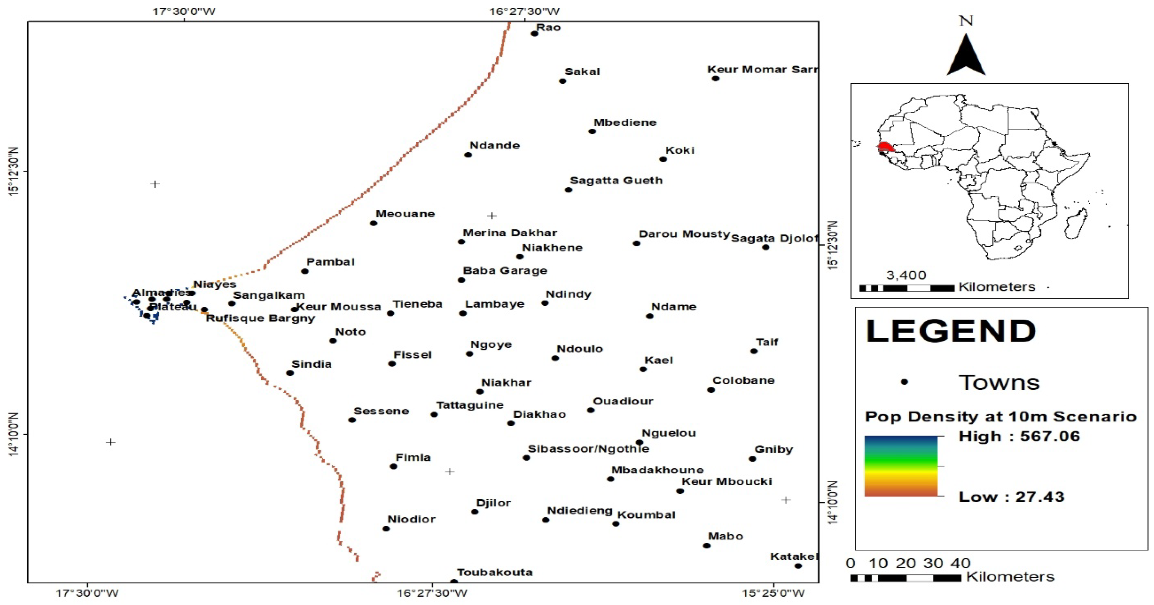
Figure 17.
Communities and population displacement at 10m shoreline shift in Senegal.
The map above displays major cities and towns in Senegal that will be affected at 10m change in the shoreline. Prominent of these are Dakar and Almadies which are projected to be heavily impacted given the huge population and the concentration of other economic activities in the cities. This could plunge the economy and reverse development gains as most of the revenue generating sectors are in the affected cities.
The population density and communities that will be impacted at 20m shoreline shift at 20m in shown in Figure 18. It is obvious from the result of the geospatial analysis that sea level rise and shoreline changes at 10m will result to inundation of 25904.55sqkm which is the maximum while the lowest population that will be inundated is 25.77sqkm
The outcome of the scenario analsysis as shown in Figure 19 above indicates that sea level rise at 30m will lead to inundation and population displacement of 25904.5sqkm while the lowest number of people that will be affceted is 19.66sqkm. The impact is considered less under this scenario due to factors such as distance from the sea and the nature of the underlying rocks.
The morphological response of the shoreline at different scenario is shown above in Figure 20. A shift in the shoreline at any of the scenario is expected to generate varying impact on land use, population which could trigger internal migration.
Projected impact of shoreline changes across different scenarios on landuse/landcover in Kenya is shown in Table 10 above. At 10m shift in shoreline, 9.04% of cropland/agricultural production will be affected while 46.09% of settlements are expected to be risk. Similarly, 42.31% of shrubs, 15.54% of spare vegetation will be affected by 10m changes in the shoreline. Again the impact on thick vegetation is expected to be 23.52% while 0.0407% of Wetlands will be lost should the shoreline change by 10m. The projection for 20m changes in the shoreline indicates that 9.76% of cropland and agriculture will be affected while 44.88% of settlements along the coastline will be at risk. 43.04% of shrubs, 15.58% of sparse vegetation and 23.31% of the thick vegetation are expected to be destroyed. The graphical representation of the result is shown in Figure 21 below
As shown in Figure 21 above, most of the impact on the land use/land cover of the study area is projected to manifest more at the 20m scenario. This implies that there will be huge loss of arable land and vegetation should the shoreline shift further at 20m
Table 11 above reveals that shoreline changes at 10m, the maximum number of people expected to be affected is 577.46sqkm, while 1210.55sqkm is the maximum population projected to be at risk if the shoreline changes at 20m. The highest impact is projected to occur at 30m where 7737.32sqkm of people are expected to be at risk in Kenya
The impact of shoreline changes in 2022 on population density is shown in Figure 17 while table11 provides insight on the minimum and Maximum population density base on the three-scenario used. Currently, the maximum number of people that shoreline changes due to erosion has affected is 33646.2sqkm. The various towns and cities that are at risk are clearly indicated on the imagery
The impact of shoreline changes at different scenarios on population indicates that at 10m, 10260.97sqkm will be at risk same for 20 and 30ms as shown in Table 18. The maximum number of people expected to be effected with 10m shift in shoreline is 10260.97sqkm along the shoreline while the minimum population will be 728.80 Sq km. For the 20m shoreline scenario projection, The maximum number of people projected to displaced will be 10260.97sqkm along the shoreline with 483.38 Sq Km as the minimum and finally the maximum number of people projected to be effected with 30m shift in shoreline will be 10260.97sqkm along the shoreline while the minimum will be 405.24 sq km. Overall the result indicates that most of the displacement is projected to occur at the 10m shoreline scenario.
3.5. Analysis of Adaptation and Coping Strategies of Population Vulnerability to Shoreline and Coastal Erosion
This section examines adaptation and coping strategies to the risk of coastal erosion in the study area. This was achieved through administration of structured questionnaire to elicit response from the population of study. A total number of 400 questionnaires were administered, out of which 295 was returned, representing more than 50% response rate. The results are presented as follows:
Migration indicators
Respondents were asked to comment on the major driver of environmental migration in their respective regions and the result of the analysis as presented in Table 19 and Figure 23 indicates that coastal erosion and drought account for 40.6% and 27% of the causes that trigger environmental migration. Others factors that drives environmental migration from are natural disasters such as floods 13.5% and land degradation 10.2%. This implies that increasing rates of coastal erosion and sae level rise can force people to migrate for safety.
Questions were asked for respondents to comment on the degree of exposure of people to the risk of coastal erosion and the result is presented in Table 20 and Figure 24. The results indicates that 35.9% of respondent’s live near the coast and therefore increased vulnerability to the risk of coastal erosion while 27.1% are into farming, 28.8% are predominantly fishermen and 8.1% are into tourism. This implies that there is high propensity by those who are acutely exposed to coastal erosion to migrate to migrate to other areas as a away of escape.
From Table 21 and Figure 25, respondents remarked that 30.2% of people living in the affected regions are affected by droughts while 33.9% of people’s livelihoods are affected by coastal erosion. 20.3% of respondents believe floods affect their homes and livelihoods given the intensity and frequency of rainfall in their region. 10.2% believe they suffer from crop losses while 5.4% of respondents mentioned landslides of the environmental problem affecting them. This implies that coastal erosion and other environmental factors can actually compelled people toi migrate if the situation continues to deteriorate.
To ascertain the gender dimensions in migration, respondents were asked on the gender that is frequently involved in migration. The result of the analysis as shown in Table 22 and Figure 26 indicates that 54.2% of people that are involved in environmental migration are men followed by youths 33.8%. 11.8% of those that responded affirmed that women are not actively involved in migration
COPING STRATEGIES OF MIGRANTS
Attempt was made to examine the coping strategies of those expose to coastal erosion and climate change hazards and the result from the questionnaire survey as demonstrated in Figure 27 and Table 23 indicate that 33.8% strongly agree that reflectiveness is one of the strategy they employed while 25.4% agrees on the use of reflectiveness. However, 16.9% disagree on the use of reflectiveness while 15.2% only disagree. 8.5% were different
The result of the analysis carried out on changing job as a coping strategy as shown in Table 24 and Figure 28 revealed that 50.8% strongly agree on changing job as a coping strategy in the face of threats from coastal erosion and environmental migration while 27.1% only agrees to the question. Those that strongly disagree and disagree are 15.2% and 6.8%. Globally, environmental migrants take up new jobs when they arrived in their new location as coping strategy. Similarly, those are decided to stay in their homes also change occupation in the face of continues threat from coastal erosion and other climate induced hazards.
The efficacy of protecting the shoreline/building sea wall as a measure of mitigating against the effect of coastal erosion was put to test as shown in Figure 29 and Table 27 with 56.3% of respondents in their submission strongly agree on the shoreline to be protected and building of sea wall to reduce the impact of coastal erosion. 25.7% simply agreed to the question while 13.5% objected strongly to the measure. Only 4.4% of respondents disagree with the question.
Sharing and bearing is an internationally known coping strategy often deployed by both internal and international migrants. In this study as captured in Table 29 and Figure 30 above indicates that, 33.9% strongly agree in using the sharing and bearing coping strategy while 31.5% agree with the question. 16.9% responded strongly disagree while 13.6% Disagreed with the use of sharing and bearing the pains arising from being forced to leave their ancestral homes. 4.1% were however indifferent.
4.0. Discussion
The preceding sections of this study have addressed substantially the nexus between shoreline and land use/Land use changes and internal migration tendency. Findings from the geospatial analysis employed in the study revealed increasing rates of erosion leading to tremendous shifts in the shoreline along the coast. Findings implicated coastal erosion and other marine processes as sea level rise as responsible for the morphology of the shoreline. Erosion rates were particularly higher in 1986,2006 and 2016 in all three countries studied with a falling trend observed in 2022. The study also established increasing rates of accretion indicating that erosion which is on a falling trend has seen accretion increase in recent times. The impact of shoreline changes on coastal resources, livelihoods, and migration is enormous as it has the potential to influence people’s decision to migrate for safety reasons. The report of the Internal Displacement Monitoring Centre, (IDMC2020) that in 2019, 2 million people were displaced across sub-Saharan Africa because of natural disasters including coastal and shoreline hazards further lends credence to the validity of this research.
For the Landuse/Land cover dynamics conducted in the study area, findings revealed that valuable land has been lost to coastal erosion and other marine processes along the coastline. The result further affirms that -972.03sqkm of land has been lost to coastal erosion in Senegal from 1986-2022 with 2016-2022 described as the period with the highest in terms of land loss. In Kenya, -463.30sqkm of land has also been lost to coastal erosion and agents of wave processes with 1986-2006 recording the highest share of -87.74% loss of valuable land while In Tanzania, -1033.35sqkm of valuable land has been loss from 1986-2022 to coastal erosion with 2006-2016 alone recording -10.4634% of land loss. Land is a valuable natural capital with huge economic potential and inestimable value, with the increasing loss of this natural resource to erosion, the impact on livelihoods and migration is huge as people will be stripped of valuable economic resources with increased vulnerability and risk. Similar studies by Torelli, (2019) affirm that coastal communities that depend on agriculture or coastal livelihoods face a disproportionately higher risk of adverse consequences and are mostly likely to face multiple compounding threats across food, water, and energy systems. Shoreline changes due to coastal erosion and land loss is well pronounced along Africa’s coastal belt and have also been reported in Ghana in a study conducted by Atayi, et, al, 2022 on shoreline changes and landuse/land cover along the Keta coast in Ghana revealed that the Keta coastline has experienced more erosion than accretion from 2000 to 2021 thus supporting the findings reported in this study.
In investigating shoreline and sea level rise modeling and its impact on population, landuse/Land cover on migration in Senegal, Kenya, and Tanzania. Findings from the study revealed that at 10m changes in the shoreline, 4.28%, of forestland, 23.933% of waterbodies, and 23% of the existing wetland will be affected while at shoreline at 20m will affect 4.24% of the forested lands, 23.68% of waterbodies and 39.77% of the wetlands. At 30m changes in shoreline, the impact on the vegetation will be 4.43% of the forested lands 21.57% of waterbodies, and 40.18% of the standing wetlands will be at risk in Senegal. In Tanzania, the model projection for shoreline changes at 10m on land use will see 24.76% of forestland, 4.28% of grassland, 23.93% of cropland, and 40.18% of wetlands will be at risk. In Kenya, the result of the geospatial model projection at 10m,20m, and 30m shows the massive impact on the natural vegetation and spread of settlements and urban growth along the shoreline. The projection was also made on the impact of shoreline changes at different scenarios on population density in Senegal, Kenya, and Tanzania, the result indicates that at 10m change in the shoreline, the maximum population per density that will be affected is 567.06sqkm while at 20 and 30 meters, 25704.55sqkm per density and 25904.55sqkm is the maximum population that is projected to be at risk in Senegal. For Kenya, the maximum population projected to be at risk is 577.46 per square kilometer while at 20m, 1210.25 is the maximum population at sqkm projected to be at risk. The projection at 30m indicates that the maximum population per square kilometer that will be displaced is 7737.32 per sqkm. The model also projects the impact on population density per square kilometer to be affected at 10, 20 and 30m shifts in the shoreline. At 10m, the maximum population density per sq km projected to be affected is 1026097sqkm, same as at 20 and 30 meters. Studies by DECCMA,2018 on natural hazards and migration corroborate the findings established in this study that environmental-related factors could trigger migration as 2.87% of migrants in three deltas namely the Ganges-Brahmaputra-Meghna Delta in India and Bangladesh, the Mahandi Delta in India and the Volta Delta in Ghana cited environmental reasons for moving. In contrast, 62.26% cited economic reasons. A Similar study by Van der Geest (2011) on migration in Ghana further supports the findings of this research that West Africa is experiencing a substantial flow of migrants from the interior savanna to the forest and coastal zones and previous studies on the climate migration nexus has often underrated environmental degradation in the Brong Ahafo Region as migration drivers.
This above narrative aptly captures the enormity of the impact of coastal erosion and changes in the shoreline could have on the environment, population, settlements, and livelihoods which could increase internal migration and population displacement. Finding established in this study agree with earlier studies conducted by studies by Lincke and Hinkel (2020) that land loss due to inundation from shoreline changes, coastal erosion and climate extremes totalling 60,000 km2 to 415,000 km2 resulted in migration of up to 17–72 million people or 0.23%–0.97% of the global population in 2015. The IPCC (2018) projects significant increase in the number of people that will be exposed to the negative impact of climate change such as sea level rise and other climate extremes will further compel people living in vulnerable regions to migrate as an adaptation strategy. This view was also shared by in their ( (Pachauri et al., 2014) studies that migration is a response to the consequences of climate change (Pachauri et al., 2014).
Findings from the section of the study on adaptation and coping strategies of residents vulnerable to shoreline changes reveal that coastal erosion is the main driver of environmental migration in the study area followed by drought and other natural disasters. Respondents affirm that those residing along the coast are the most exposed and bear most of the risk. The result of the questionnaire analysis also established that coastal erosion and sea level rise are on the rise, and this is likely to increase the propensity to migrate internally. In terms of adaptation and coping strategies, the study affirms that adaptation and coping mechanisms remain low, and this, therefore, needs to be scaled up. This position has been corroborated Mbiyozo, (2020) that Migration offers options for individuals, families, and communities facing climate threats thus relieving pressure on limited resources. Furthermore, people whose livelihoods depend on climate and environmentally sensitive resources use Migration as a critical resilience strategy against climate change impacts Respondents assert that migrants received no assistance from any source in their new location and appealed for intervention while the majority of the respondents support shoreline protection and building of sea walls to mitigate the impact of coastal erosion and other agents of sea encroachment. Finally, findings revealed that men and youths are more likely to migrate than women and this shows the gender dimension in environmental migration in the three countries covered.
5. Conclusion and Recommendation
The research significantly enhances our knowledge of the effectiveness of the GIS and remote sensing modeling for assessing shoreline changes, erosion developments, as well as land uses and cover alterations. Their implications in the context of population dynamics and intraurban migration are also covered by this paper. The results highlight the worrying outlining of the coastal-spatial era between 1986-2022 significant with a reference of shoreline retreat and modifications that pose a risk to peoples' dispersion patterns, settlements, and the natural ecosystem. The research brings to light not just the fact that there is 75% vegetation cover but that there is escalating deforestation with urban growth along (the ) coastline that contributes to factors like excessive road congestion and the urban heat island effect. Also, the study shows an evident lack of adoption of coping mechanisms in coastal communities. Coastal erosion has been convincingly found to mainly contribute to environment-induced migration as implied by a thorough review of questionnaire responses so that nothing remains unseen. Hence, the recommendation of the study is the creation of special development organizations in Favor of low-elevation coast zones of every country under examination. This authority has to be specifically made responsible for developing those strategies and action plans, tailored to the wide protection of shoreline resources and rigorous coastal zone monitoring. Further, migration ideas are to be understood and integrated into the conventional development programming schedules. Multidimensionality of climate change-induced migration issues can be investigated and grasped better through mainstreaming hence improving capacity to respond to climate change-induced mass displacements. The study provides evidence that stagnant actions towards erosion, deforestation, and climate change migration issues can be dangerous. The course of action advocated can serve to lay the foundation for resilience and sustainable development in regions prone to erosion but which at the same time face multiple issues of environmental degradation and mass population movements.
Authors' Contribution
The first author (Oye Ideki) conceived and developed the research plan including simulation and analysis, while the second, author reviewed the draft manuscript including data visualization.
COMPETING INTERESTS
The authors declare that there is no competing interest.
Acknowledgment
The authors acknowledge the significant contribution of the United Nations Economic Commission for Africa UNECA and the African Institute for Development and Economic Planning (IDEP) based in Dakar Senegal for their support to the first author during his research fellowship.
References
- Adegoke, T.O, Fageia, M; Godstime. J; Agbaje, G and Ologunorisa, T (2010) An assessment of recent changes in the Niger Delta Coastline using Satellite Imagery. Journal of Sustainable Development Vol 3, No 4. [CrossRef]
- Atayi, J; Twumasi, Y.A; Ning, Z.H; Asare-Ansah, A.B (2022) A study of shoreline changes and land use/land cover along the Keta coastal zone. The international Archives of the photogrammetry, Remote sensing and spatial information sciences, Volume XL, ASRRS Annual conference Denver, Colorado, USA.
- Awuor, C.B. Orindi, V.A and Adwera, A.O (2018) Climate change and coastal cities: The case of Mombassa, Kenya, Environment and urbanization, Institute for Environment and Development (IIED), Vol.20 (1).
- Balha, A., and Singh, C. K. (2022). “Comparison of maximum likelihood, neural networks, and random forests algorithms in classifying urban landscape,” in Application of remote Sensing and GIS in natural Resources and built infrastructure management water science and technology library. Editors V. P. Singh, S. Yadav,.
- . [CrossRef]
- DECCMA, Climate change, migration and adaptation in deltas: key findings from the DECCMA project, 2018, available online at https:// generic.wordpress.soton.ac.uk/deccma/wp-content/uploads/ sites/181/2017/02/online-version –.
- ECA/ACPC (2022) 8th Session of the Africa Regional Forum on Sustainable Development AFRSD Kigali Rwanda.
- Faye, A Mohamadou D, Diakhaté, P.B; Bèye, A; Sall, M; Diop, M (2021) Senegal - land, climate, energy, agriculture and development: A study in the Sudano-Sahel Initiative for regional development, jobs, and food security, ZEF Working Paper Series, No. 202, University of Bonn, Center for Development Research (ZEF), Bonn.
- Internal Displacement Monitoring Centre,( 2020) Global report on internal displacement, sub-Saharan Africa, April 2020, www.internal-displacement.org/global-report/grid2020/ downloads/2020-IDMC-GRID-sub-saharan-africa.pdf?v=1.1.
- IOM (2022) World Migration Report, 12 Vilnius Lithuania.
- IPCC. (2018) Global Warming of 1.5°C—An IPCC special report on the impacts of global warming of 1.5°C above pre-industrial levels and related global greenhouse gas emission pathways, in the context of strengthening the global response to the threat of climate change, sustainable development, and efforts to eradicate poverty. The Intergovernmental Panel on Climate Change.
- Islam M.S, Crawford T.W and Shao Y (2023), Evaluation of predicted loss of different land use and land cover (LULC) due to coastal erosion in Bangladesh. Front. Environ. Sci. 11:1144686. [CrossRef]
- Lal, P., Shekhar, A., Gharun, M., and Das, N. N.(2023). Spatiotemporal evolution of global long-term patterns of soil moisture. Science of The Total Environment, 867, 161470. [CrossRef]
- Lambin, E. F., and Geist, H. J. (2008). Land-use and land-cover change: Local processes and global impacts. Springer Science & Business Media, Berlin, Germany.
- Lincke, D., and Hinkel, J. (2021). Coastal migration due to 21st century sea-level rise. Earth's Future, 9, e2020EF001965. [CrossRef]
- Luijendike,A; Hagenaars,G; Ranasinghe, and Aarninkhof, G (2018) State of the world beaches: Scientific reports.
- Maranga,A (2020) Sea level rise evade development in Africa, EOS,101 available online at htps://doi.org.1oza/2020.
- Mbiyozo,A.N (2020) Policy brief: Migration, a critical climate change resilience strategy. Institute for security studies, Hanns Seidel Foundation.
- Mentaschi, L., Vousdoukas, M.I., Pekel, J. F. et al. (2018) Global long-term observations of coastal erosion and accretion. Sci Rep 8, 12876. [CrossRef]
- Misra. A and Balaji, R (2015): A study on the shoreline changes and land use/land cover along the South Gujirat Coastline Coastline. 8th International Conference Asia and Pacific (APAC) Science direct. Processing Engineering 116, Elsevier.
- Ndubi, A; Mugo, R; Okello. L and Ouko E (2015) Mapping of coastal erosion/ Degradation hotpots in Kenya, Tanzania, Mozambique, and Madagascar. SERVIR-Eastern and Southern Africa.
- Nguyen, Q. H., and Takewaka, S. (2020). Land subsidence and its effects on coastal erosion in the Nam Dinh coast (vietnam). Cont. Shelf Res. 207, 104227. [CrossRef]
- Nguyen, Q.H and Takewaka, S (2020) Land subsidence and its effects on coastal erosion in the Nam Dinh Coast (Vietnam),Continental Shelf Research, Vol. 207, 104227,ISSN 0278-4343. [CrossRef]
- Nicholls, R.S; Kebede, A.S and Brown, S (2018) The implications of climate change and sea level rise in Tanzania’s coastal zones. The University of Southampton, Tyndall Centre for Climate change Research, UK.
- Nwakumanya, M.A (2021): Beach erosion hazard vulnerability assessment in Mombasa, Kenya. International Journal of environmental science and Development.
- Nyandwi, N (2010): The major cause of Observed erosion surge in Beaches North of Dar Es Salaam City. Tanzania Journal of Science. Vol.36.
- Ideki and T. P. Abali (2022) Geospatial Assessment of Land Cover Dynamics in the Guinea Savannah Ecological Zone. Journal of Geography, Environment and Earth Science International. 26(4): 15-24, 2022; Article no.JGEESI.44995 ISSN: 2454-7352.
- Omuombo, C.A.; Olago, D.O., and Odada, E.O. (2013). Coastal erosion. Developments in Earth Surface Processes, 16,331-339. [CrossRef]
- Otukei, J. R., and Blaschke, T. (2010). Land cover change assessment using decision trees, support vector machines and maximum likelihood classification algorithms. Int. J. Appl. Earth Observation Geoinformation 12, S27–S31. [CrossRef]
- Pachauri, R. K., Allen, M. R., Barros, V. R., Broome, J., Cramer, W., Christ, R., et al. (2014). Climate Change 2014: Synthesis Report. Contribution of Working Groups I, II and III to the Fifth Assessment Report of the Intergovernmental Panel on Climate Change. IPCC.
- Pandian, P.K; Ramesh, S Murthy, M.V.R; Ramachandran, S and Thayumanavan, S (2004)"Shoreline changes and nearshore processes along Encore Coast, East Coast of South India," Journal of Coastal Research, vol. 20, pp. 828-845,2004.Available at: https://doi.org/10.2112/1551-5036 20[828:scansp]2.0.co;2. [CrossRef]
- Rigaud, K et al., (2018) Groundswell: preparing for internal climate migration, World Bank, https://openknowledge. worldbank.org/handle/10986/2946.
- Rodriguez-Galiano, V. F., Ghimire, B., Rogan, J., Chica-Olmo, M., and Rigol-Sanchez, J. P. (2012). An assessment of the effectiveness of a random forest classifier for landcover classification. ISPRS J. Photogrammetry Remote Sens. 67, 93–104. [CrossRef]
- Sally, B; Kebede, A.S and Nicholls, R.S (2010) Sea level and impacts in Africa 2000-2100. School of Civil Engineering and the Environment. University of Southampton, Southampton, UK, SO17 IBJ.
- Samanta S, Pal D. K (2016) Change detection of land use and land cover over a period of 20 years in Papua New Guinea. Nat Sci 8:138–151. [CrossRef]
- Samanta, S., Paul, S.K. (2016) Geospatial analysis of shoreline and land use/land cover changes through remote sensing and GIS techniques. Model. Earth Syst. Environ. 2, 108. [CrossRef]
- Schwartz M (2005) Encyclopedia of coastal science. Springer, Netherlands, pp 1–1097. ISBN: 978-1-4020-4871-5.
- Taveneau, A.; Almar, R.; Bergsma, E.W.J.; Sy, B.A.; Ndour, A.; Sadio, M.; Garlan, T. (2021) Observing and Predicting Coastal Erosion at the Langue de Barbarie Sand Spit around Saint Louis (Senegal, West Africa) through Satellite-Derived Digital Elevation Model and Shoreline. Remote Sens. 2021, 13, 2454. [CrossRef]
- UN- HABITAT (2008) The state of Africa cities. A framework for addressing urban challenges in Africa. UN-habitat.
- Van der Geest, K. (2011). The Dagara farmer at home and away: Migration, environment, and development in Ghana. African Studies Collection 33. Leiden: African Studies Centre.
- Wei, L., Zhang, B., and Wang, M. (2007). Effects of antecedent soil moisture on runoff and soil erosion in alley cropping systems. Agric. water Manag. 94 (1-3), 54–62. [CrossRef]
- Woodroffe, C. D., Nicholls, R. J., Saito, Y., Chen, Z., and Goodbred, S. L. (2008). “Landscape variability and the response of asian megadeltas to environmental change,” in Global Change and integrated coastal management: The asia-pacific region coastal systems and continental margins. Editor N. Harvey (Amsterdam, Netherlands: Springer Netherlands), 277–314. [CrossRef]
- World Bank 2021: Groundswell Africa report, Depp Dive into internal climate migration in Senegal. 1818 H Street Washington, DC.
- World Bank African Region (2020): The next Generation Africa Climate Business Plan, Washington DC.
- Zhang, K., Douglas, B. C., and Leatherman, S. P. (2004). Global warming and coastal erosion. Clim. Change 64, 41–58. [CrossRef]
Figure 2.
Erosion and Accretion rates.
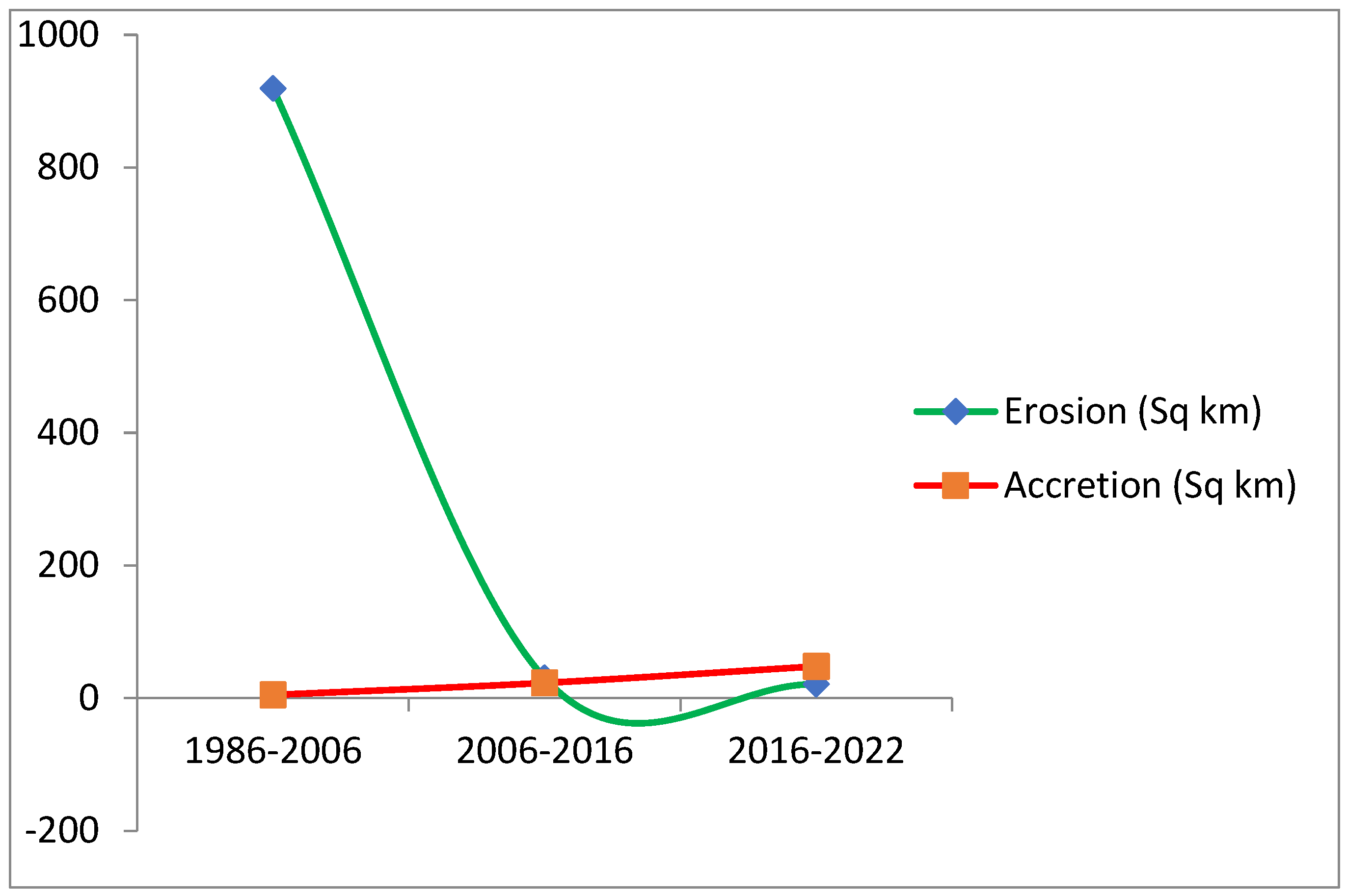
Figure 3.
Sectional representation of Senegal shoreline in 1986.
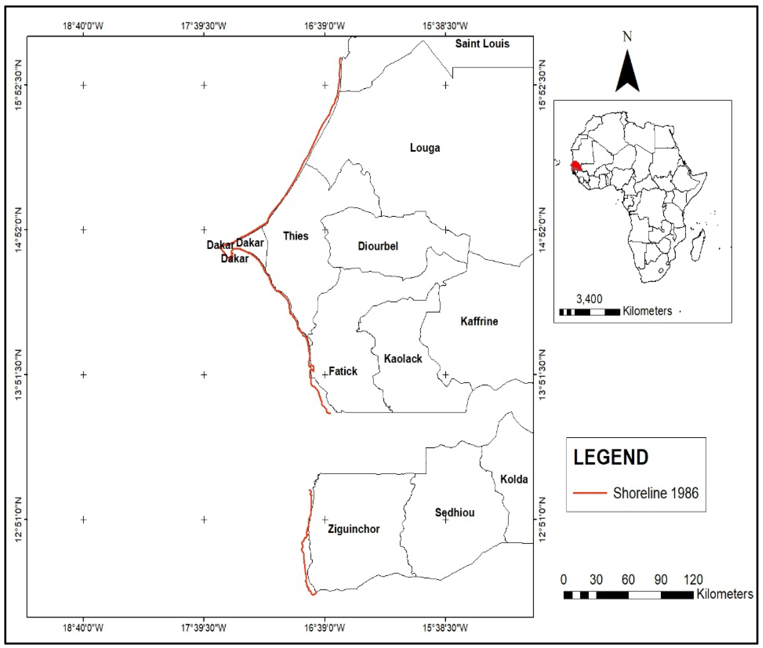
Figure 4.
Trend of Shoreline changes in 2006 in Senegal.
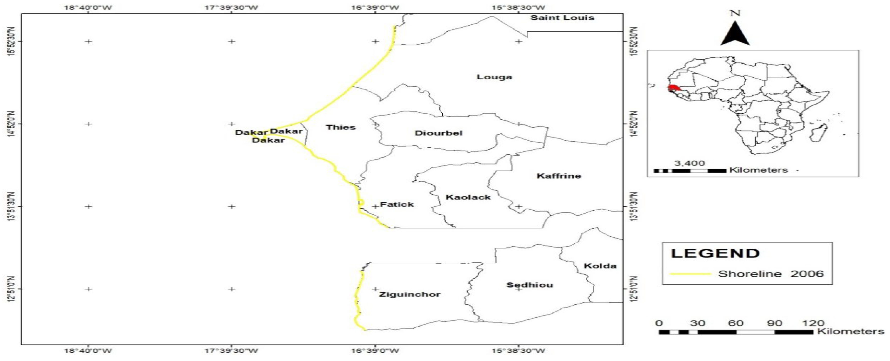
Figure 5.
Shoreline trend and in 2016.
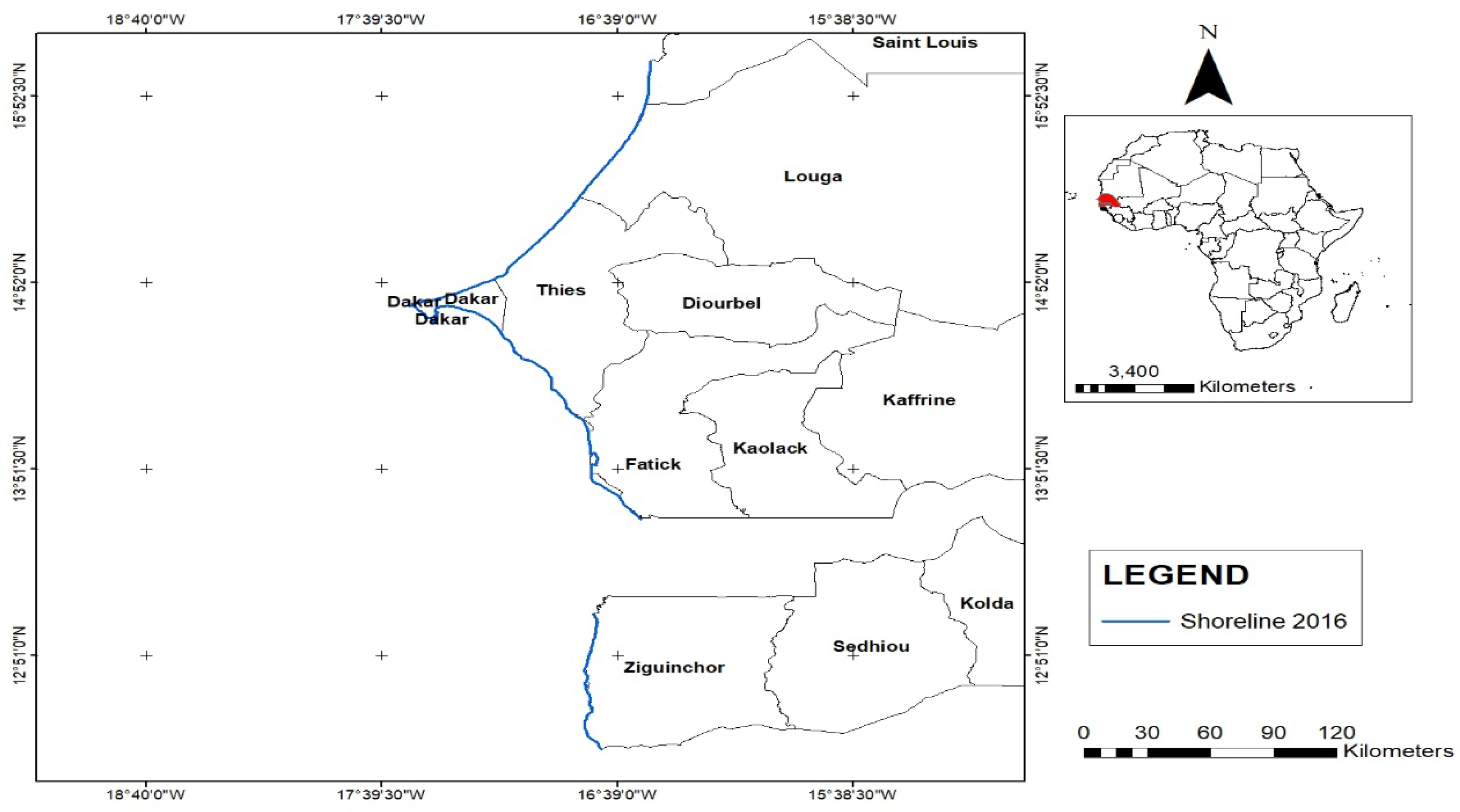
Figure 6.
:Shoreline changes in 2022.
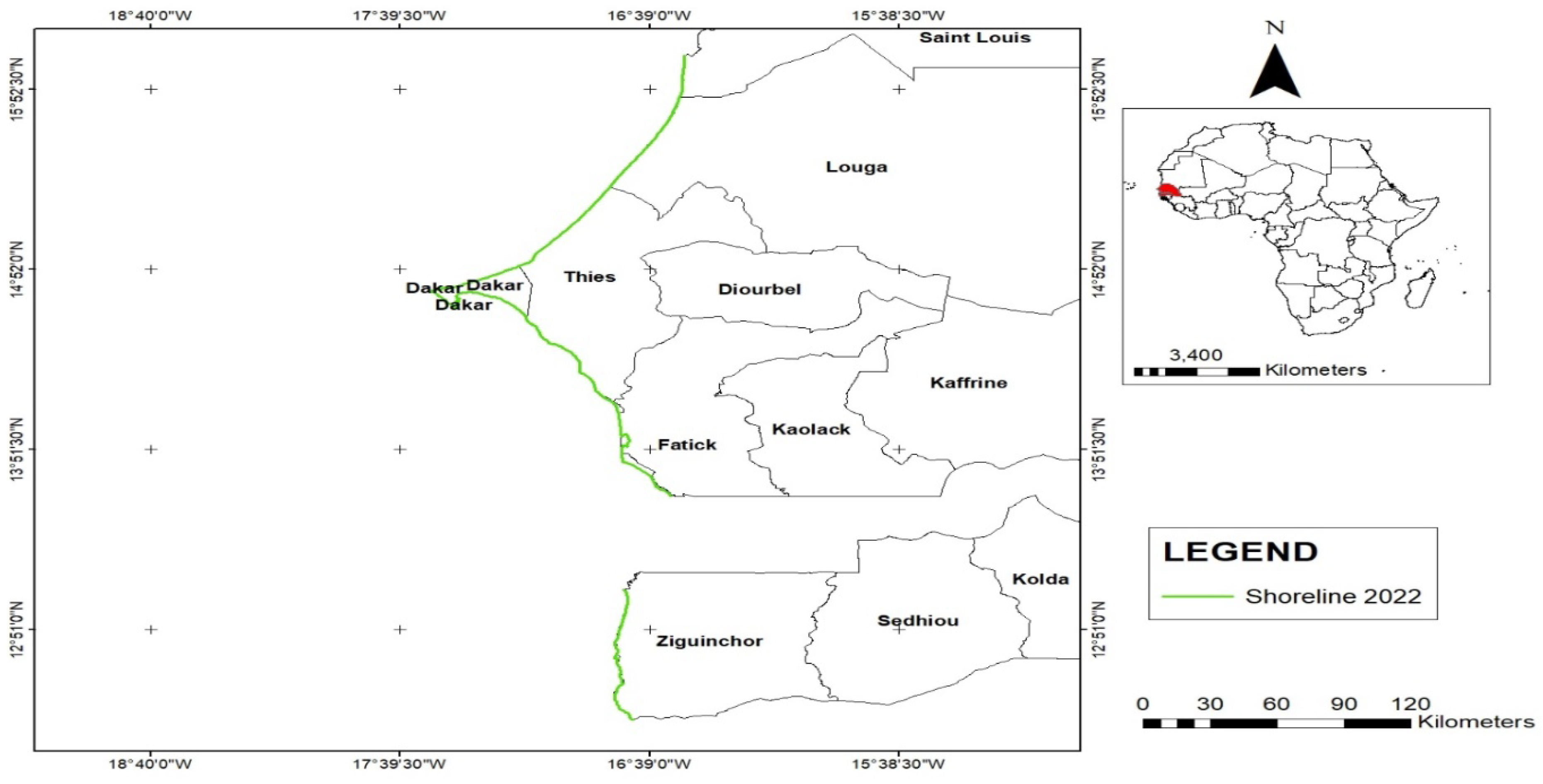
Figure 7.
Composite representation of shoreline from 2006-2022.
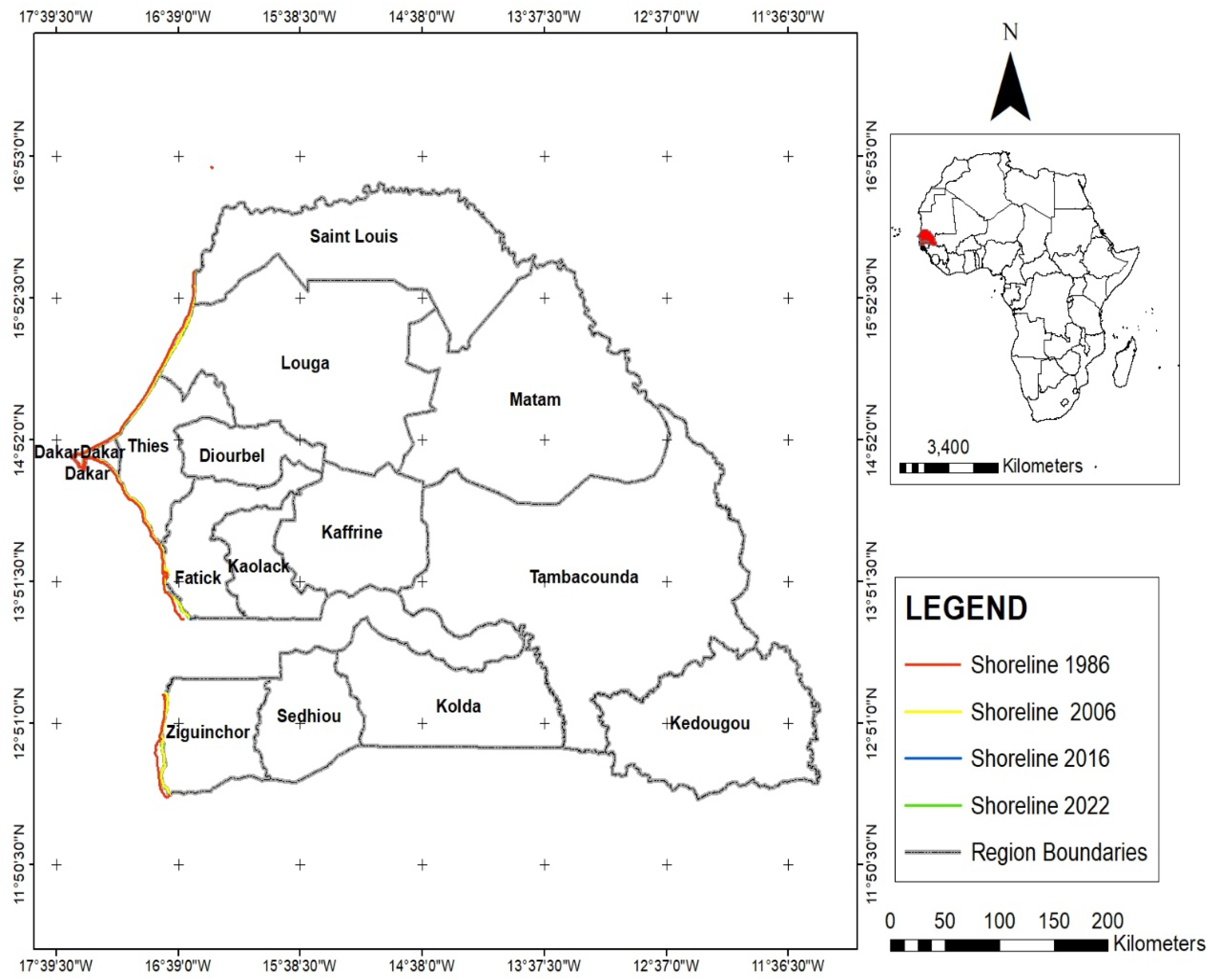
Figure 8.
Sectional Representation of the Shoreline between 1986 and 2022.
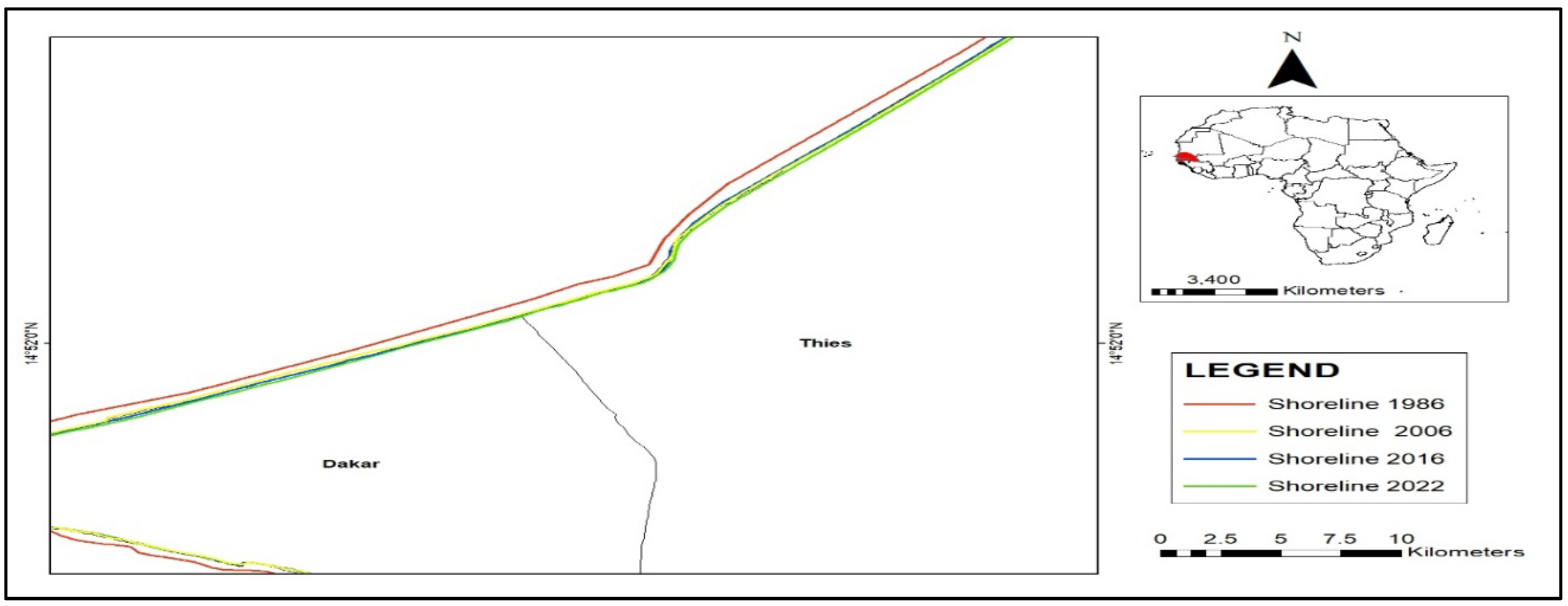
Figure 9.
Inverse view of the shoreline from 1986-2022.
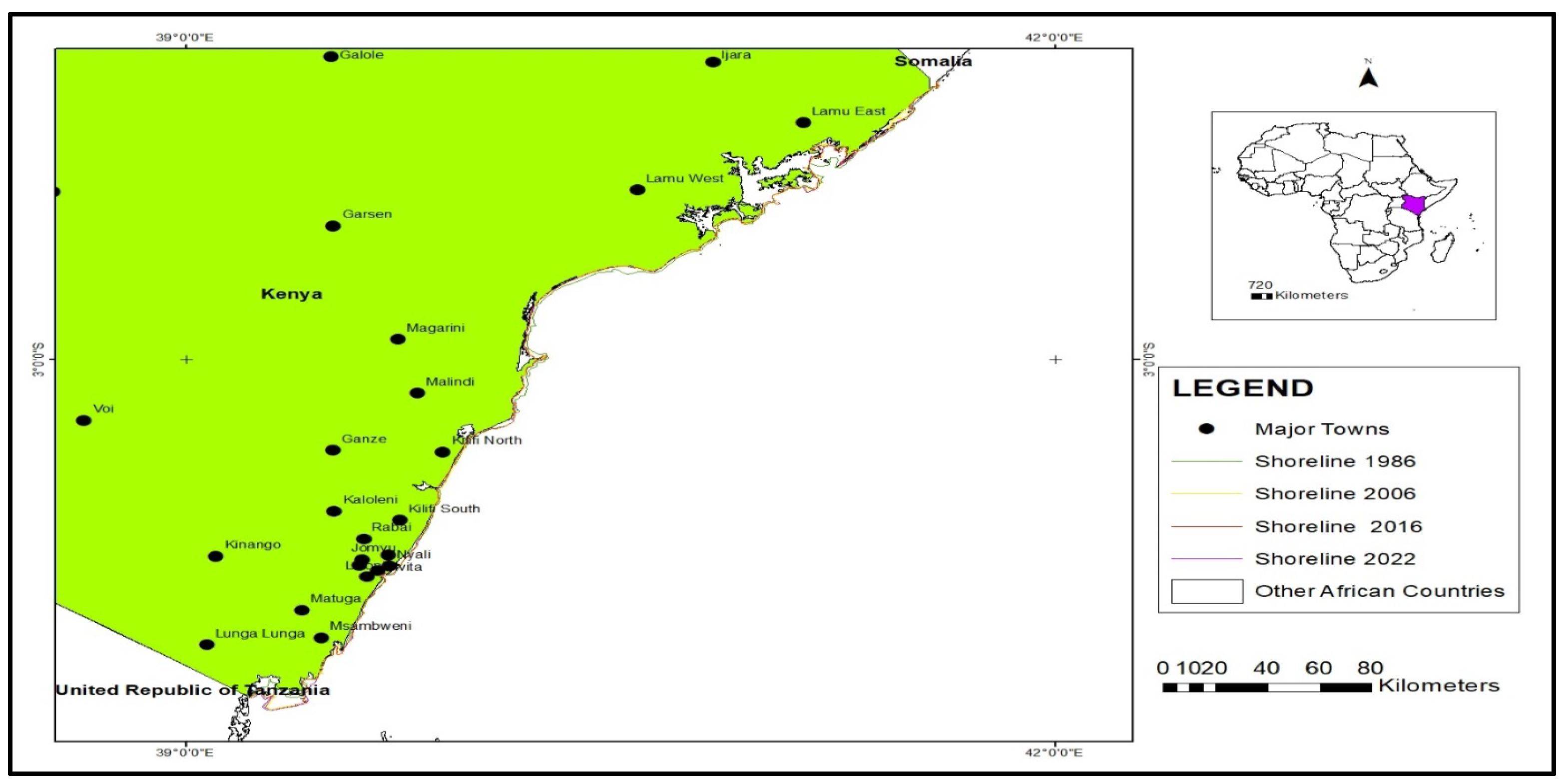
Figure 10.
Land Loss and Gain along the Shoreline in Kenya from 1986 to 2022.
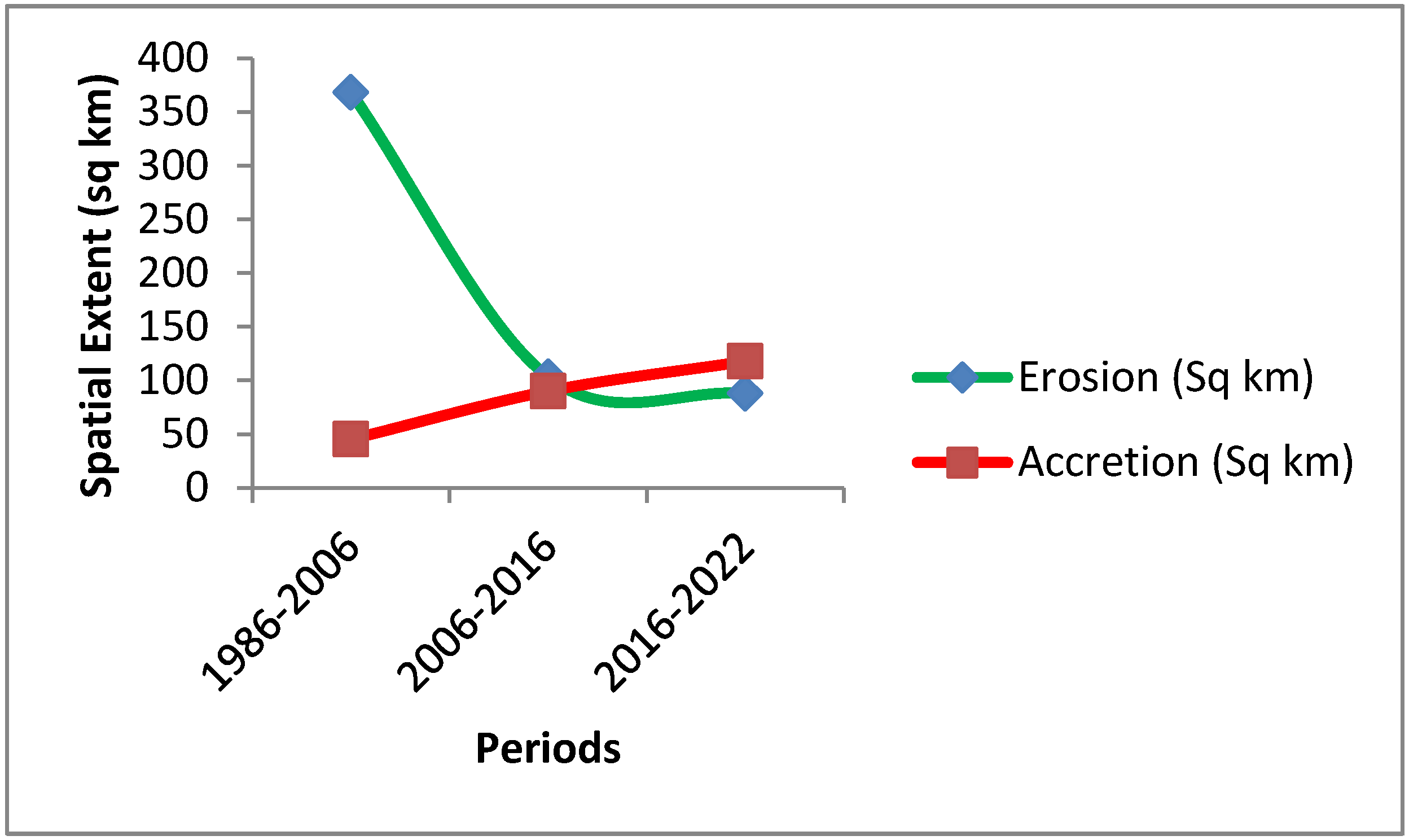
Figure 11.
Vertical view of the Tanzania shoreline.
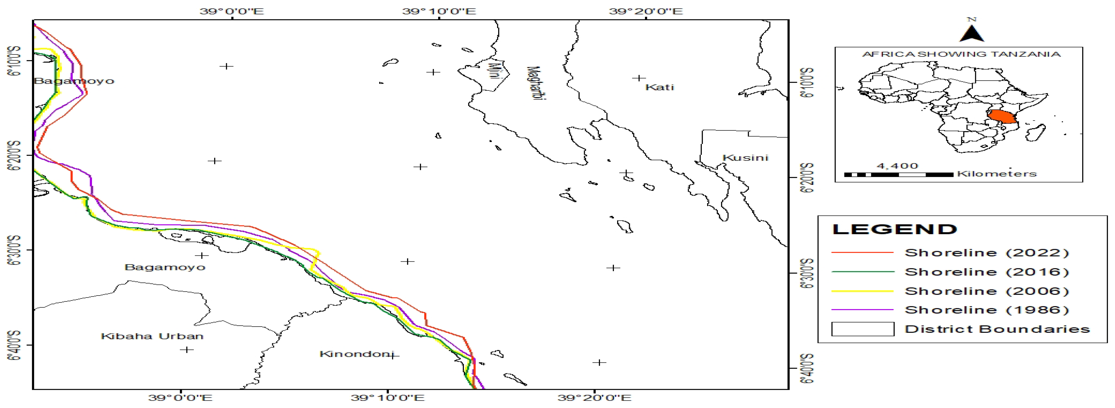
Figure 12.
Land Loss and Gain along Shoreline from 1986 to 2022.
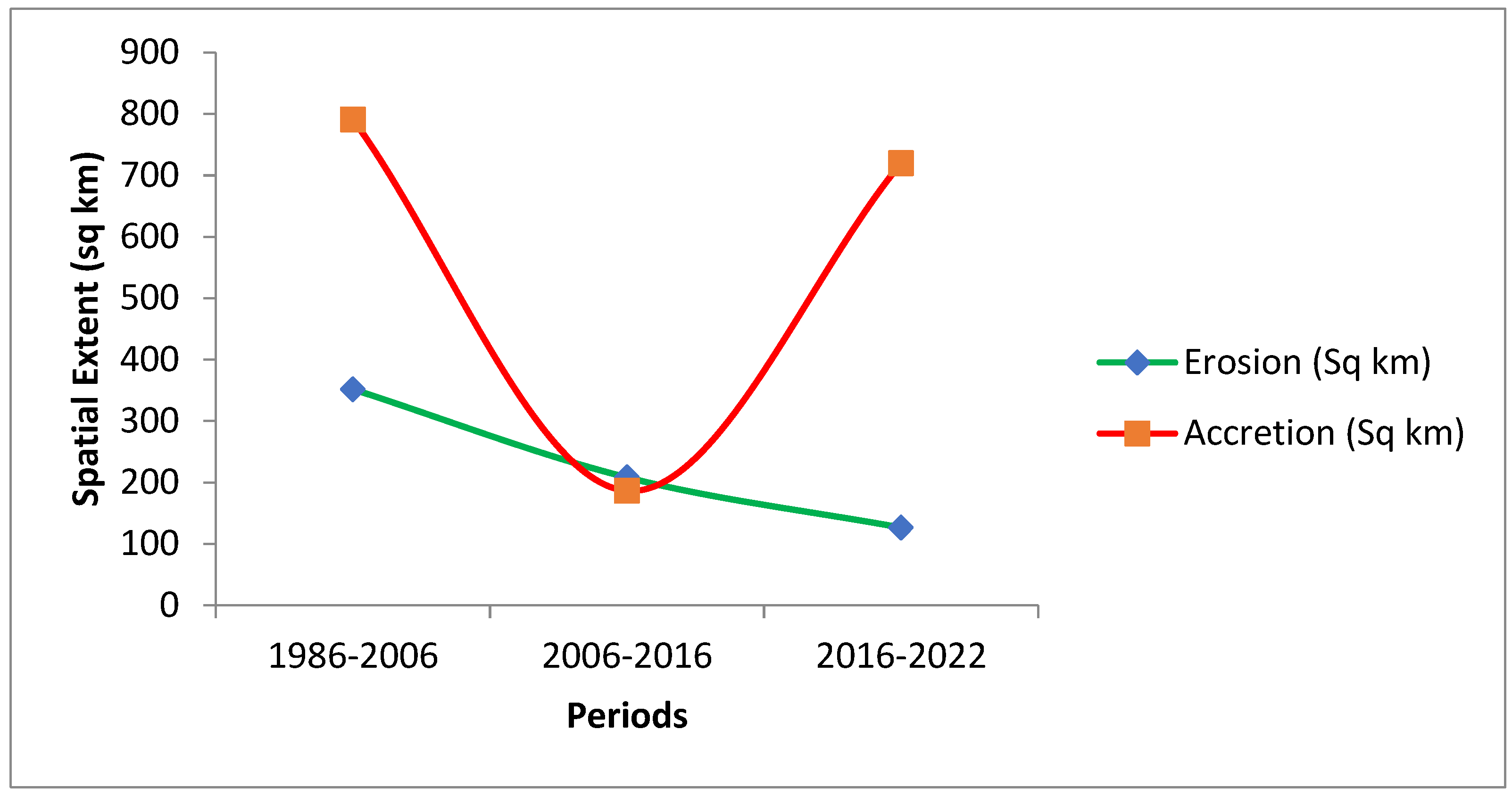
Figure 13.
: Shoreline scenario modelling on landuse/landcover.
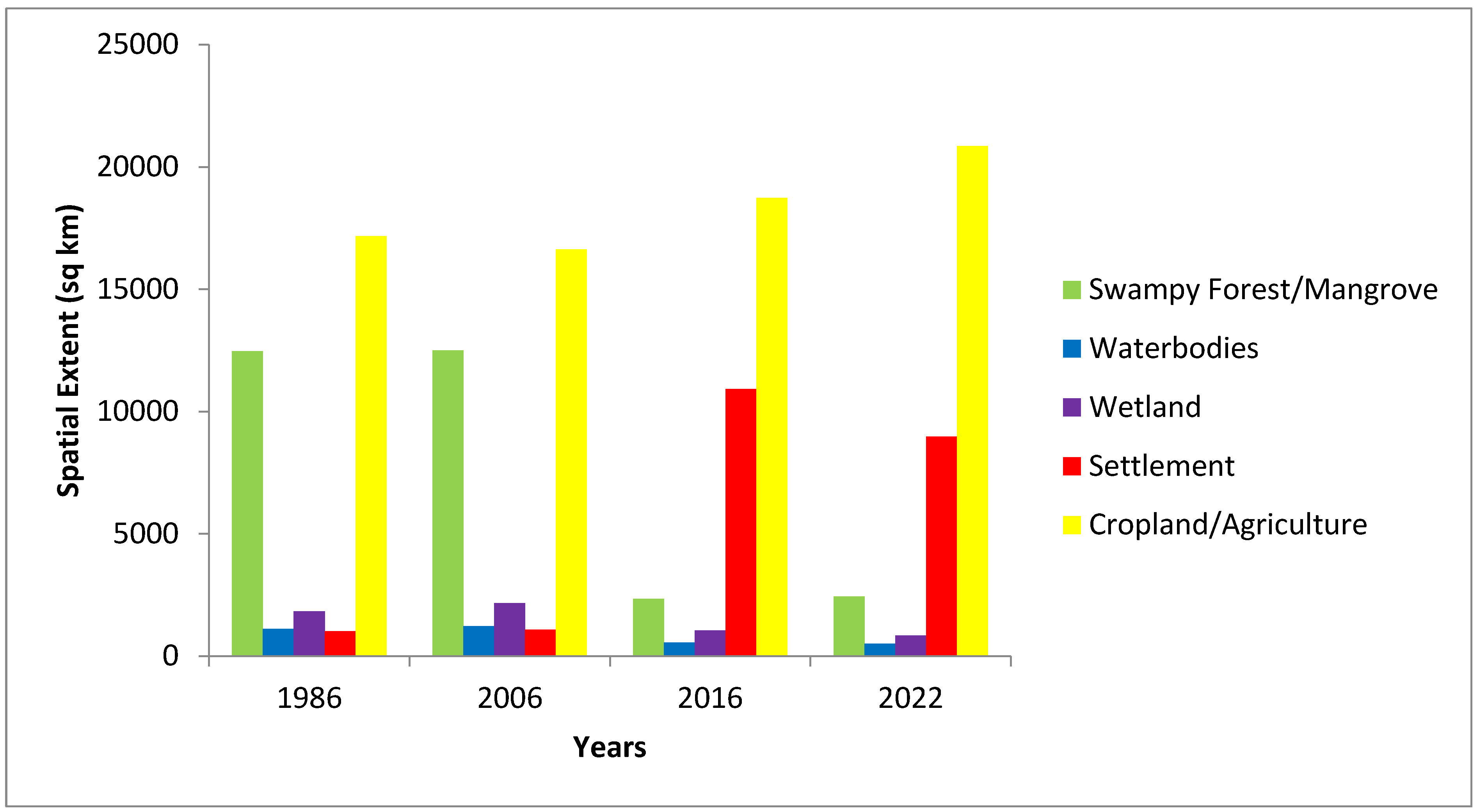
Figure 14.
Graphical representation of land cover composition and change 1986-2022.
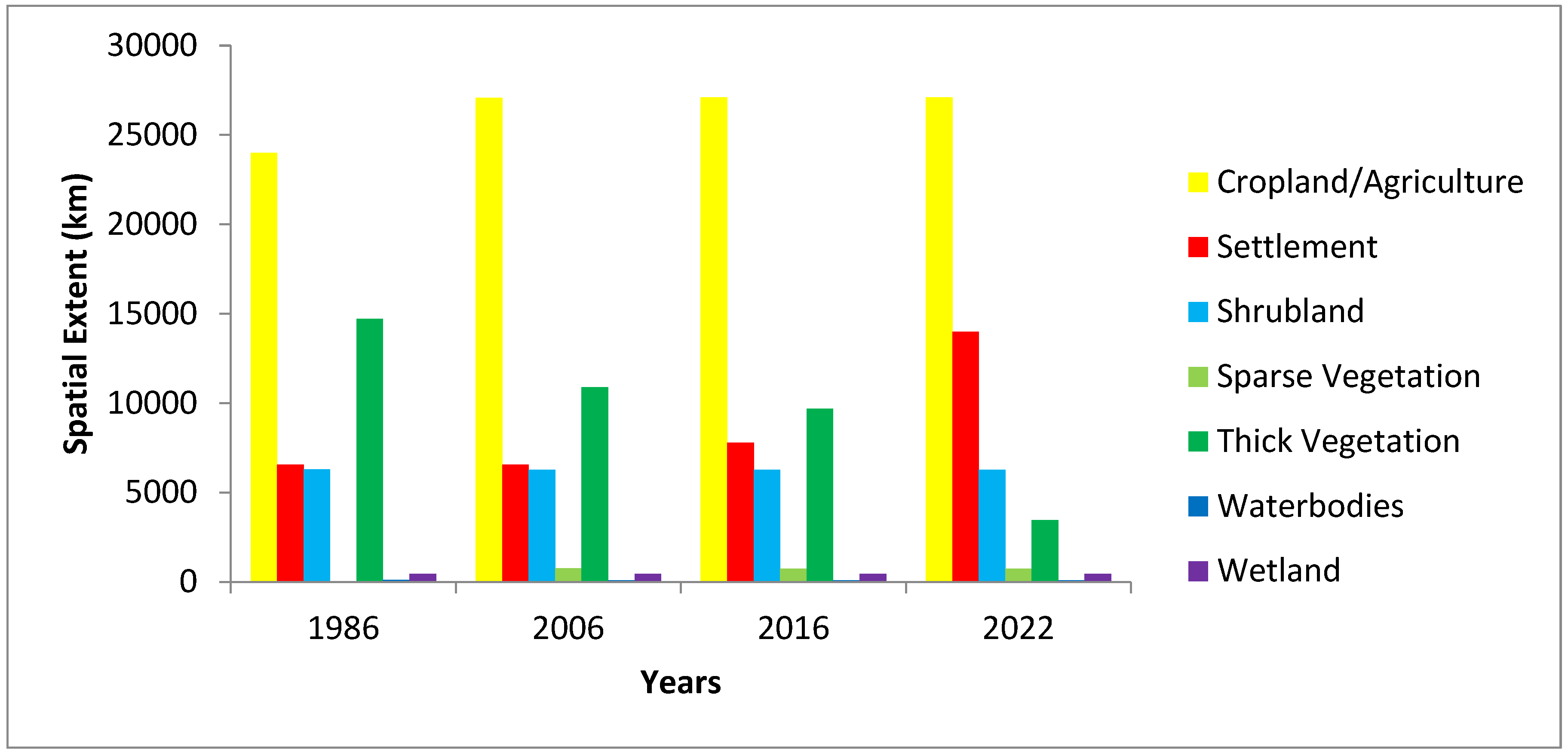
Figure 15.
Composition of land use/landcover in Tanzania.
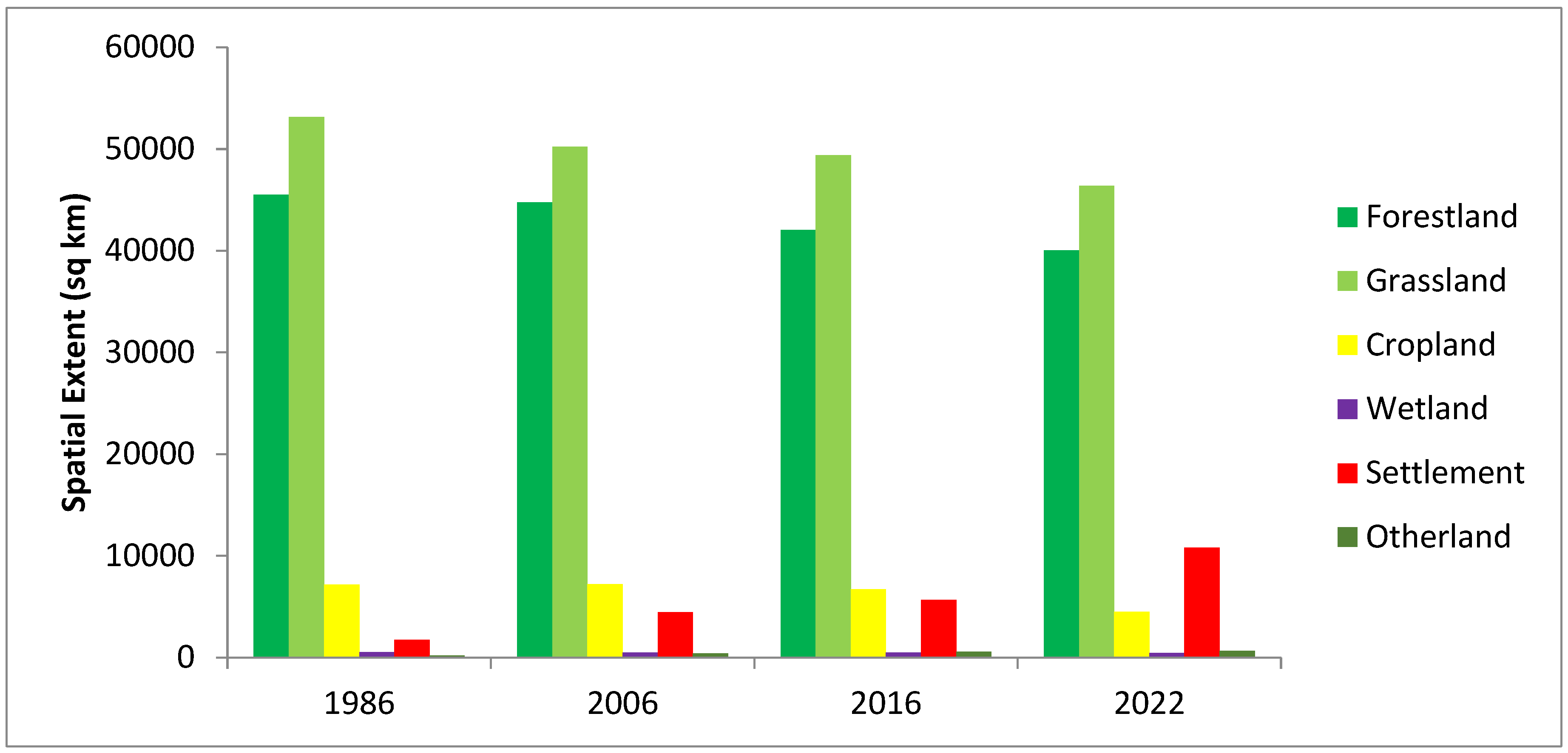
Figure 16.
: Shoreline scenario modelling on landuse/landcover.
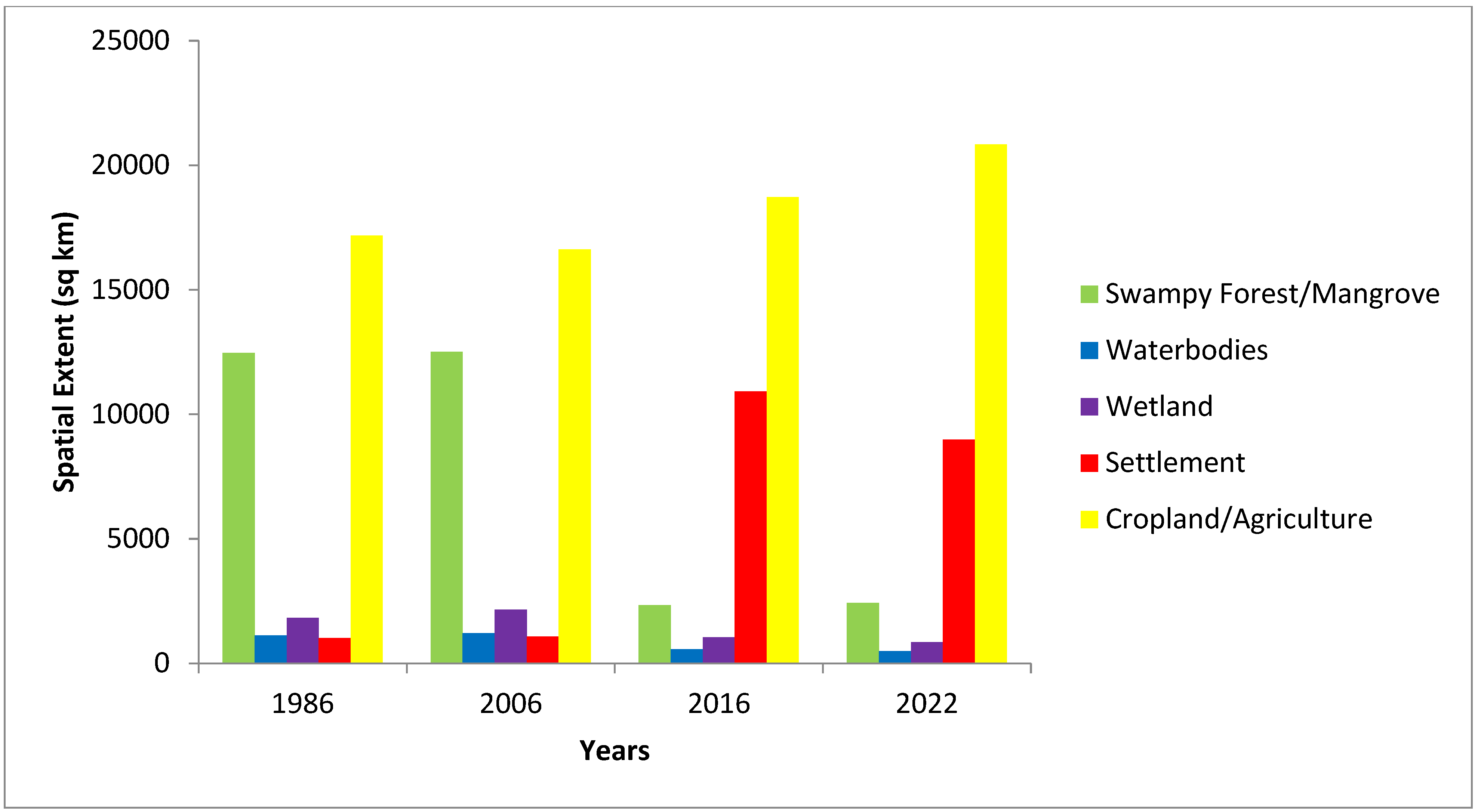
Figure 18.
Communities and population displacement at 20m shoreline shift.
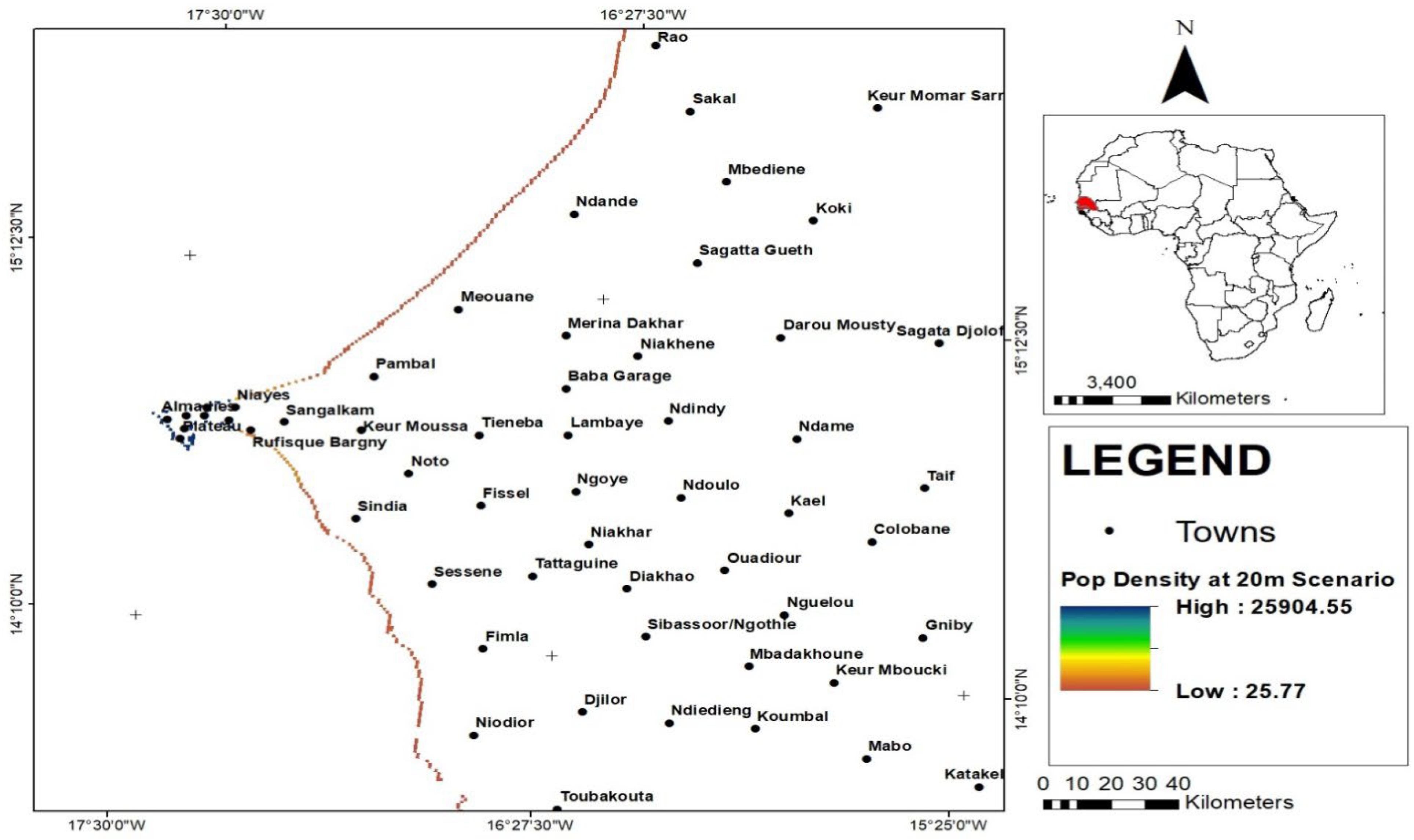
Figure 19.
Communities and population displacement at 30m Shoreline shift.
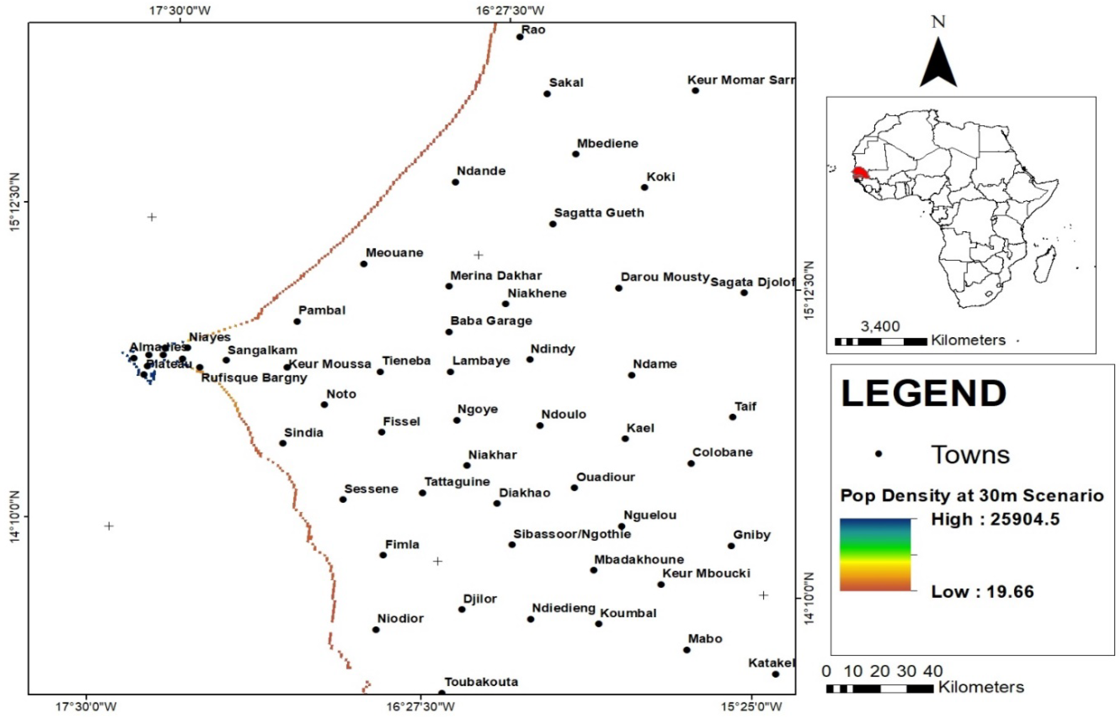
Figure 20.
A bigger section of the scenario along the Senegal Shoreline.
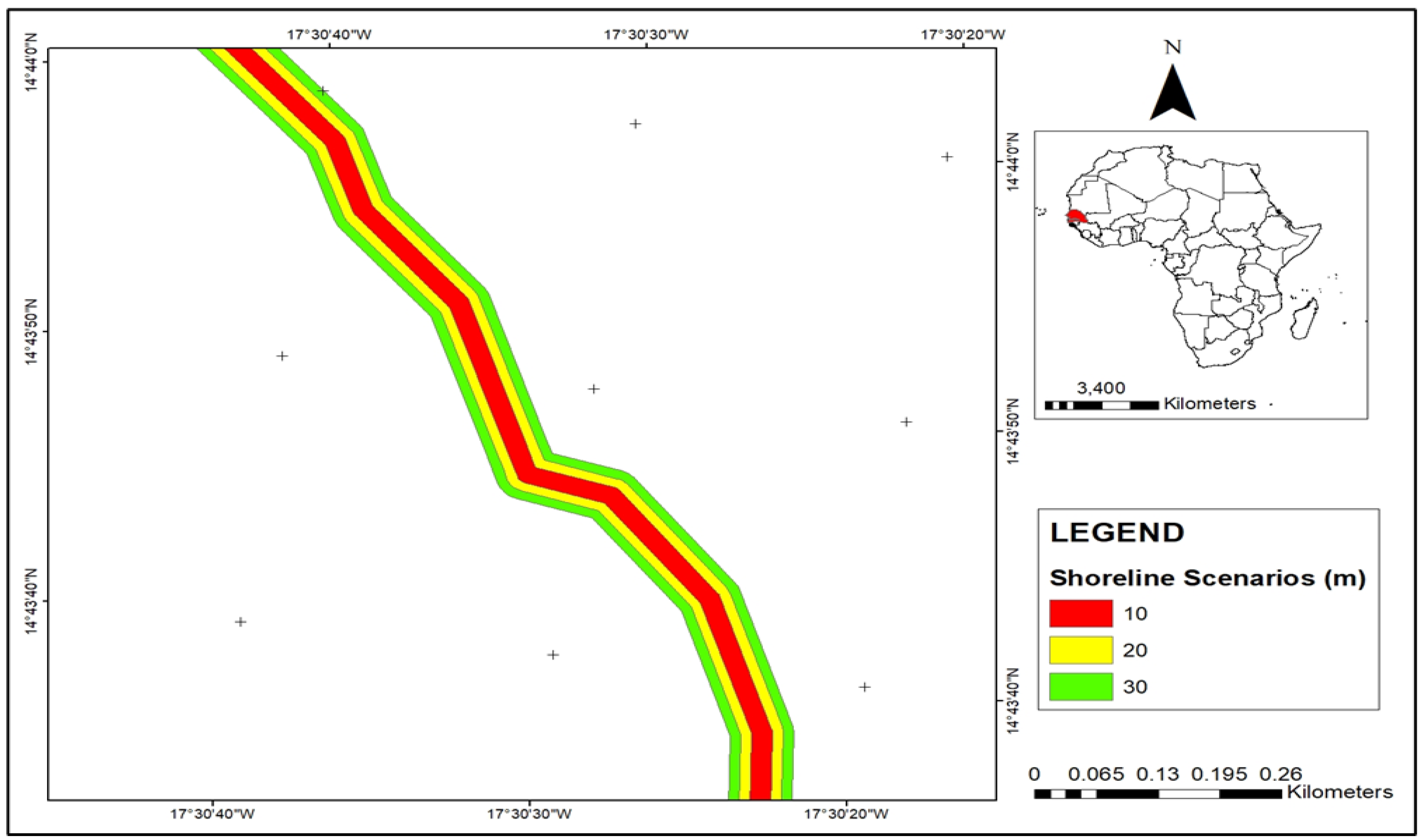
Figure 21.
shoreline changes on Landuse/Landcover
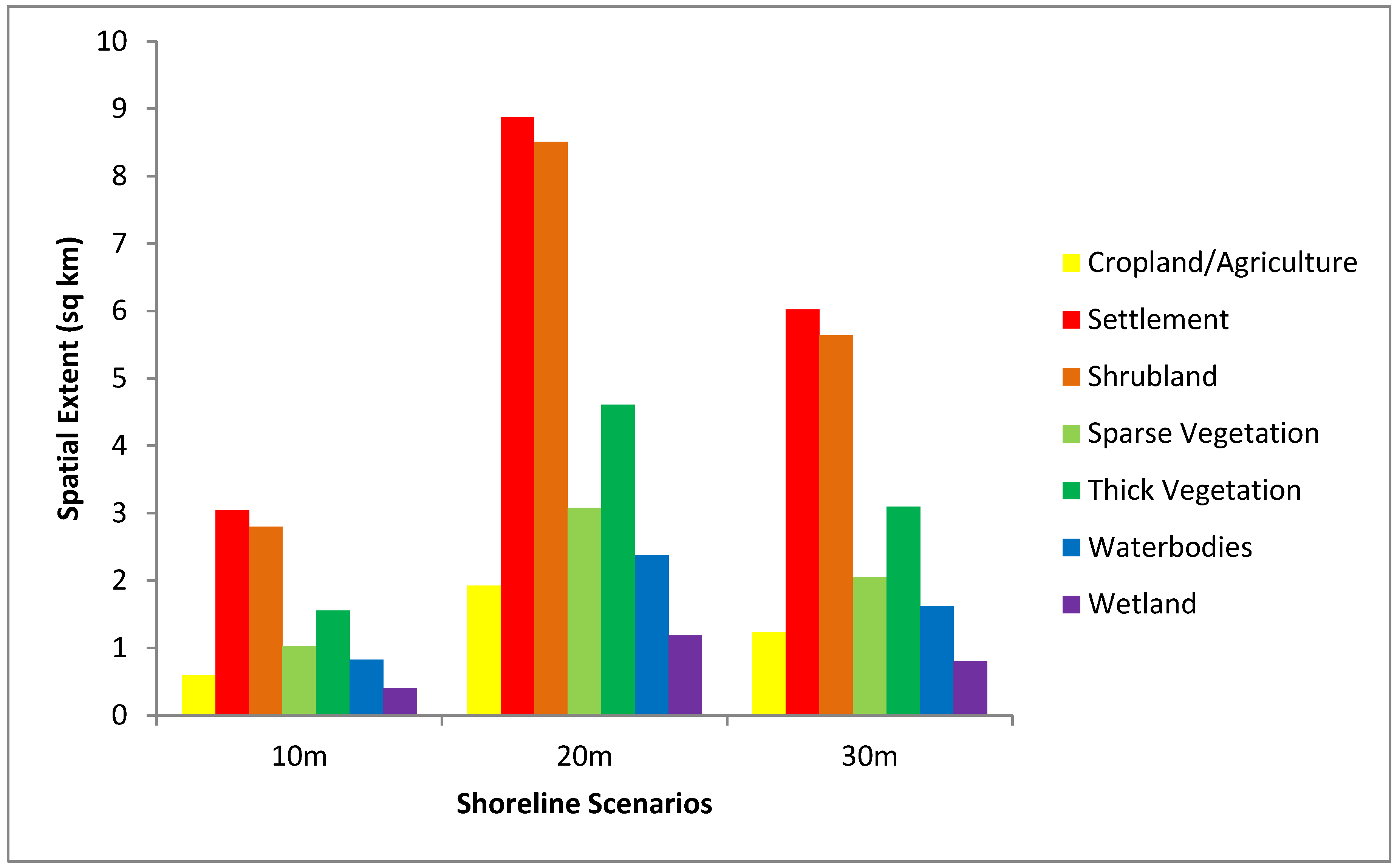
Figure 22.
Effect of Shoreline Scenarios on Population Density (sq/km) in Kenya.
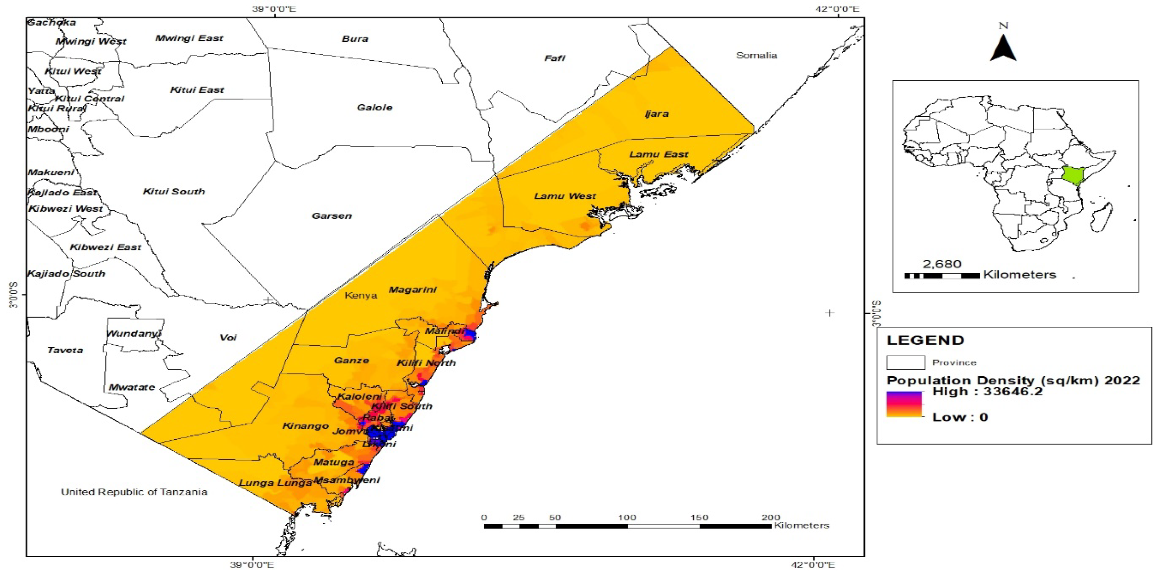
Figure 23.
Survey on major drivers of environmental migration.

Figure 24.
Degree of exposure to coastal erosion.
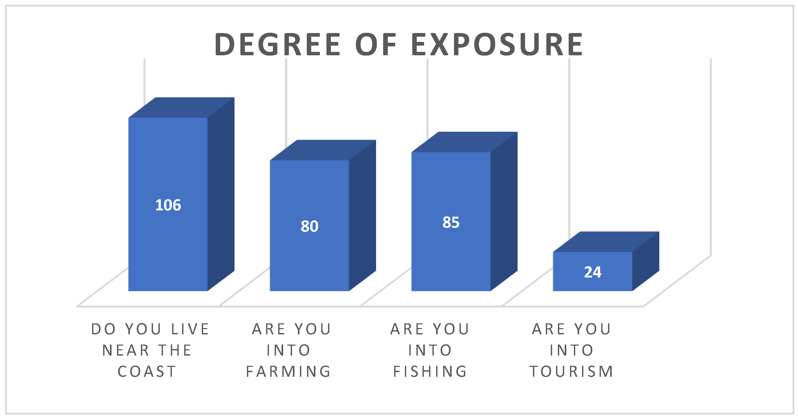
Figure 25.
Degree of impact of natural hazards.

Figure 26.
: Gender dimension of migration.
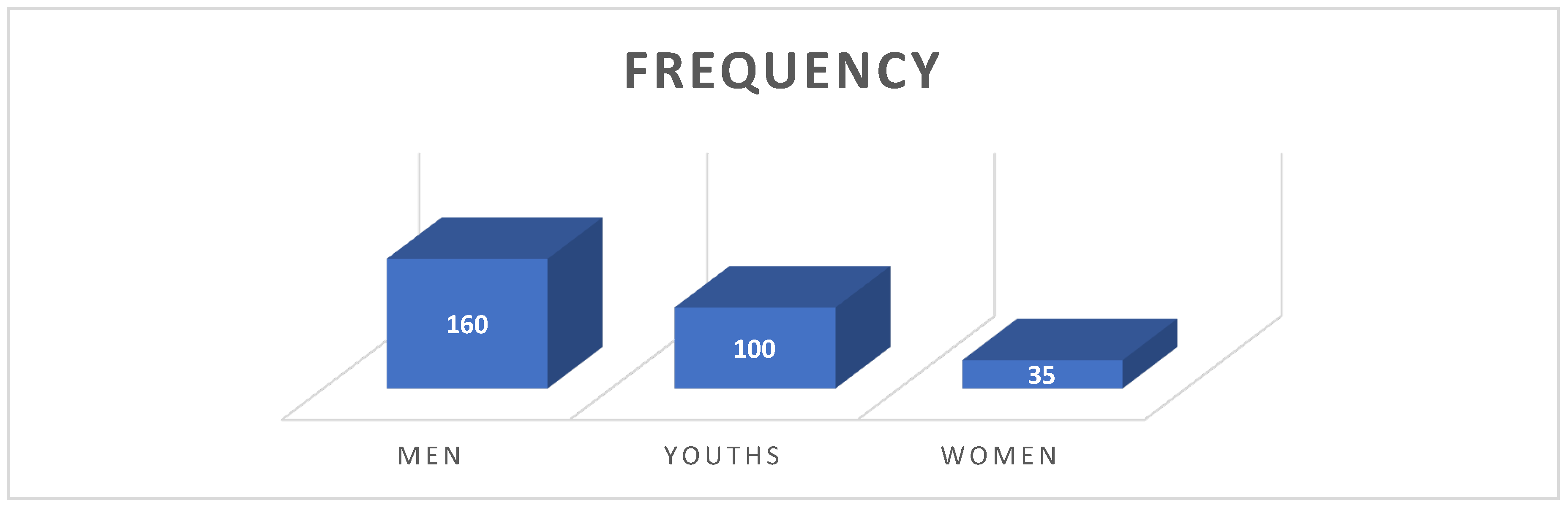
Figure 27.
Reflectiveness as coping strategy.
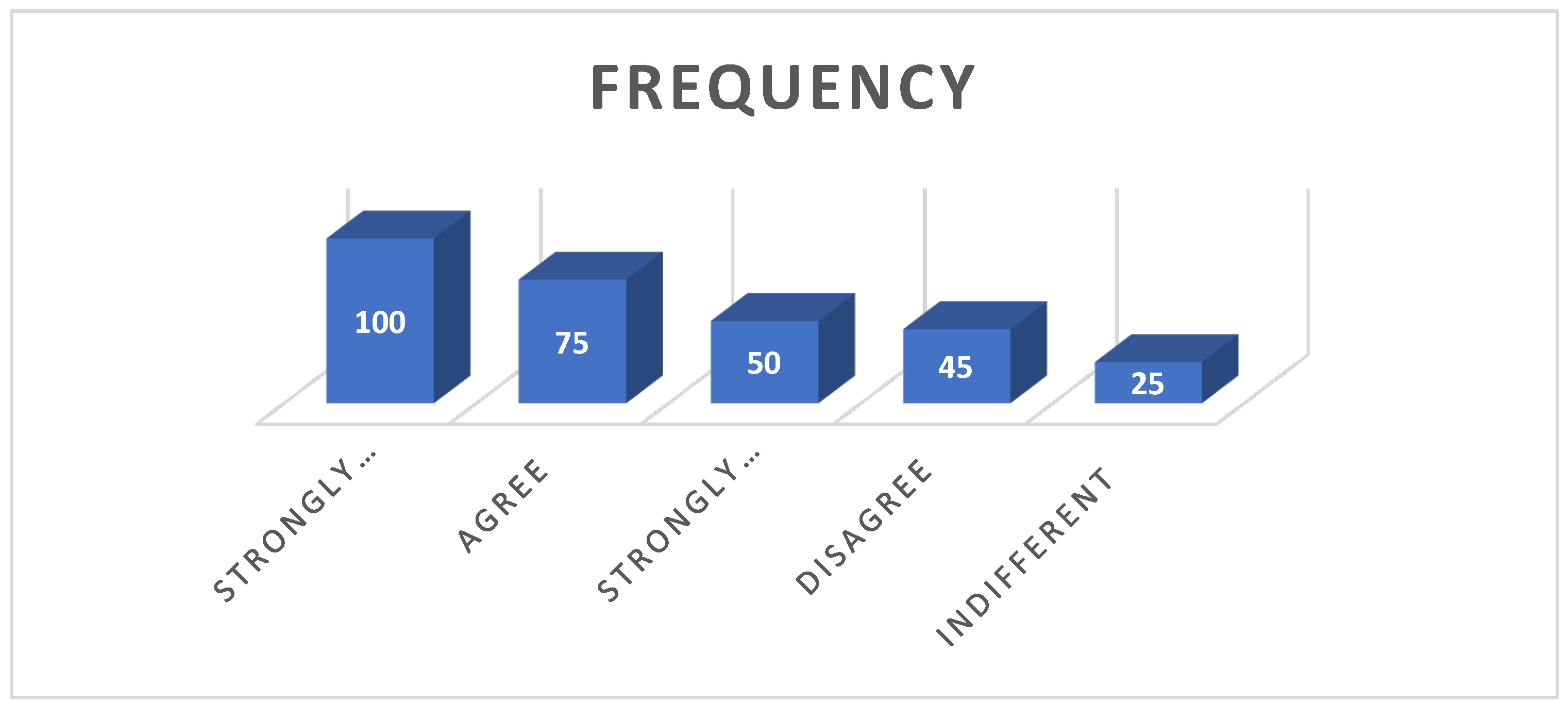
Figure 28.
Changing jobs as coping strategy.
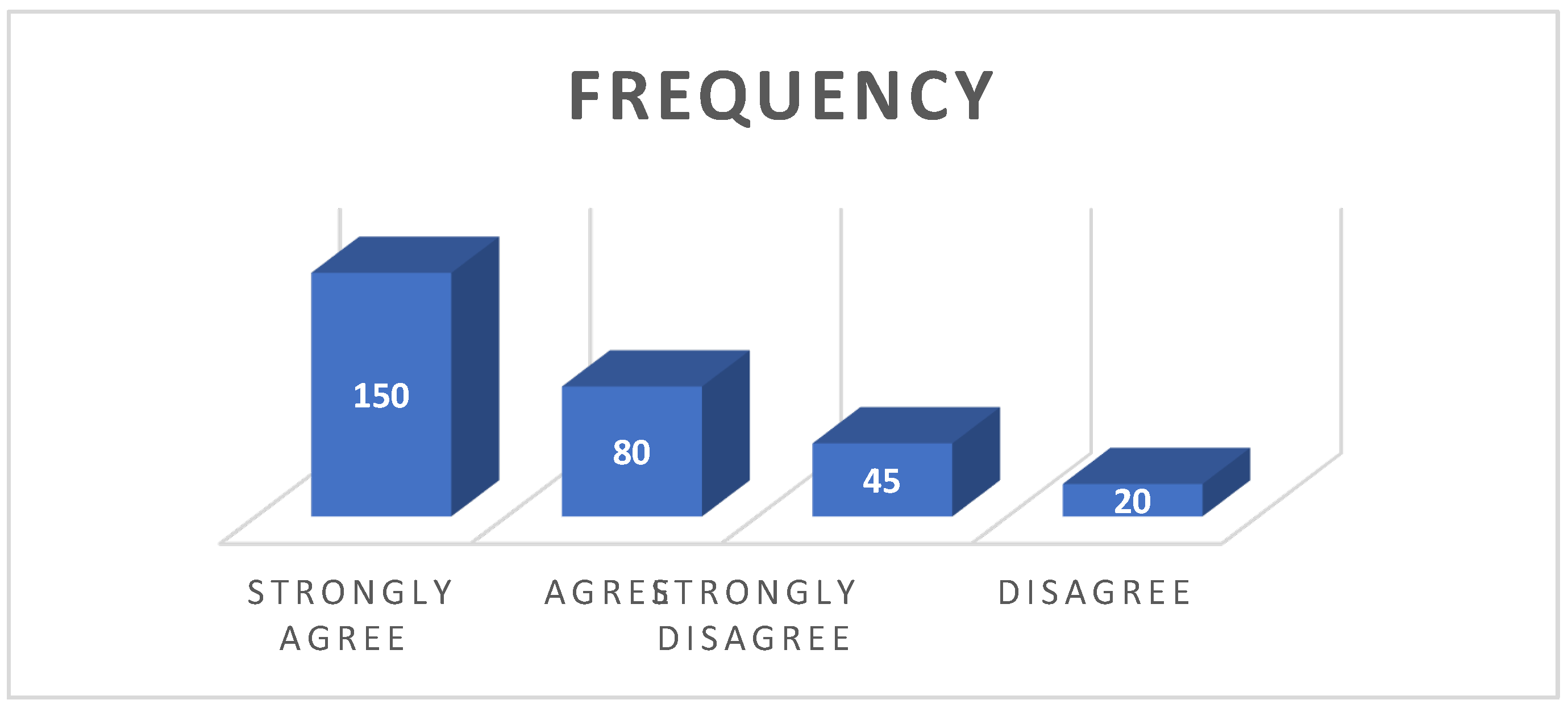
Figure 29.
Protection of the shoreline/building sea walls.
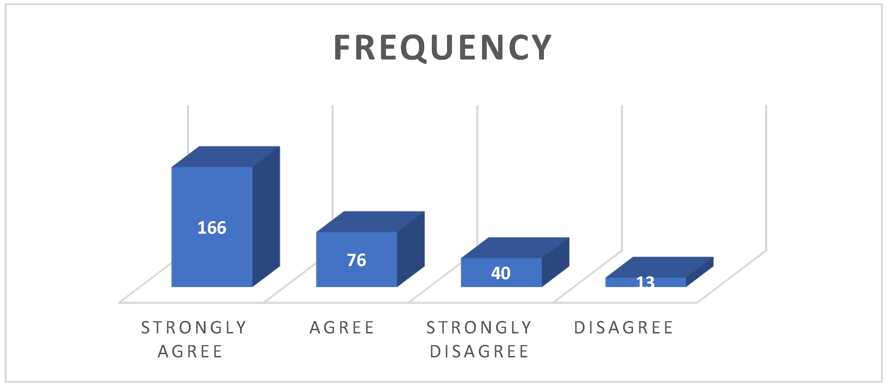
Figure 30.
Sharing and bearing as a coping strategy.
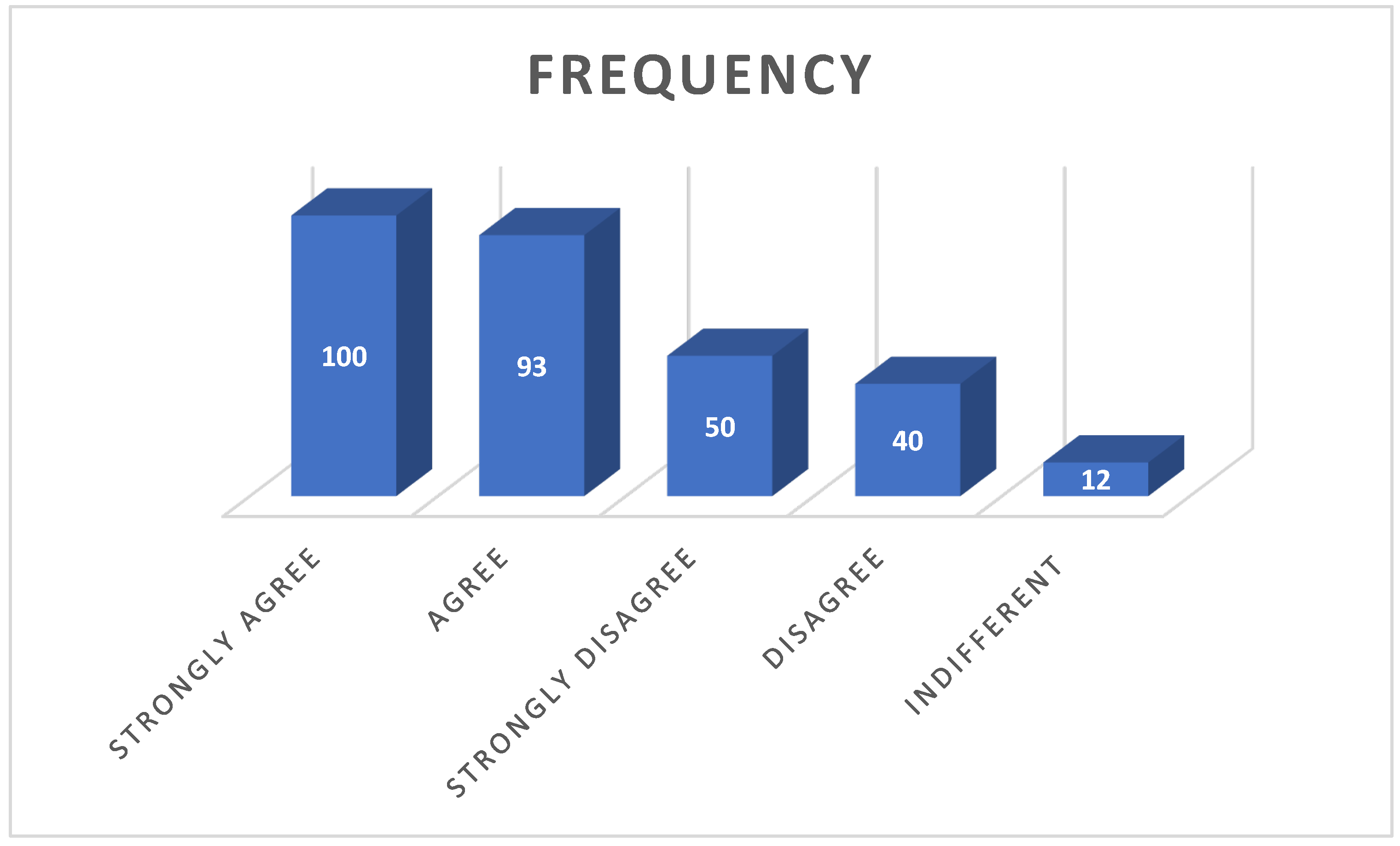
Table 1.
Image acquisition timelines.
| Country | Year | Spacecraft/Landsat Sensor | Cloud Cover Level (%) | Resolution (m) | Date of Acquisition | Path and Row | Output Format |
| Senegal | 1986 | Landsat 5 TM | 0 | 30 x 30 | 1986-10-23 | 205/049 | GeoTiff |
| Landsat 5 TM | 0 | 30 x 30 | 1986-02-25 | 205/050 | GeoTiff | ||
| Landsat 5 TM | 0 | 30 x 30 | 1986-02-09 | 205/051 | GeoTiff | ||
| 2006 | Landsat 7 ETM | 0 | 30 x 30 | 17/12/2006 | 205/049 | GeoTiff | |
| Landsat 7 ETM | 0 | 30 x 30 | 17/12/2006 | 205/050 | GeoTiff | ||
| Landsat 7 ETM | 0 | 30 x 30 | 17/12/2006 | 205/051 | GeoTiff | ||
| 2016 | Landsat 8 OLI/TIRS | 0 | 30 x 30 | 11/01/2016 | 205/049 | GeoTiff | |
| Landsat 8 OLI/TIRS | 0 | 30 x 30 | 02/05/2016 | 205/050 | GeoTiff | ||
| Landsat 8 OLI/TIRS | 0 | 30 x 30 | 31/03/2016 | 205/051 | GeoTiff | ||
| 2022 | Landsat 9 OLI/TIRS | 0 | 30 x 30 | 20/02/2022 | 205/049 | GeoTiff | |
| Landsat 9 OLI/TIRS | 0 | 30 x 30 | 19/01/2022 | 205/050 | GeoTiff | ||
| Landsat 9 OLI/TIRS | 0 | 30 x 30 | 03/01/2022 | 205/051 | GeoTiff | ||
| Tanzania | 1986 | Landsat 5 TM | 0 | 30 x 30 | 09/12/1986 | 167/063 | GeoTiff |
| Landsat 5 TM | 0 | 30 x 30 | 09/12/1986 | 167/064 | GeoTiff | ||
| Landsat 5 TM | 0 | 30 x 30 | 09/12/1986 | 166/063 | GeoTiff | ||
| Landsat 5 TM | 0 | 30 x 30 | 12/12/1986 | 166/064 | GeoTiff | ||
| Landsat 5 TM | 0 | 30 x 30 | 09/12/1986 | 167/065 | GeoTiff | ||
| Landsat 5 TM | 0 | 30 x 30 | 09/12/1986 | 166/065 | GeoTiff | ||
| Landsat 5 TM | 0 | 30 x 30 | 09/12/1986 | 165/066 | GeoTiff | ||
| Landsat 5 TM | 0 | 30 x 30 | 09/12/1986 | 166/067 | GeoTiff | ||
| Landsat 5 TM | 0 | 30 x 30 | 09/12/1986 | 165/067 | GeoTiff | ||
| Landsat 5 TM | 0 | 30 x 30 | 09/12/1986 | 165/068 | GeoTiff | ||
| 2006 | Landsat 7 ETM | 0 | 30 x 30 | 23/12/2006 | 167/063 | GeoTiff | |
| Landsat 7 ETM | 0 | 30 x 30 | 07/12/2006 | 167/064 | GeoTiff | ||
| Landsat 7 ETM | 0 | 30 x 30 | 07/12/2006 | 166/063 | GeoTiff | ||
| Landsat 7 ETM | 0 | 30 x 30 | 07/12/2006 | 166/064 | GeoTiff | ||
| Landsat 7 ETM | 0 | 30 x 30 | 07/12/2006 | 167/065 | GeoTiff | ||
| Landsat 7 ETM | 0 | 30 x 30 | 07/12/2006 | 166/065 | GeoTiff | ||
| Landsat 7 ETM | 0 | 30 x 30 | 07/12/2006 | 165/066 | GeoTiff | ||
| Landsat 7 ETM | 0 | 30 x 30 | 07/12/2006 | 166/067 | GeoTiff | ||
| Landsat 7 ETM | 0 | 30 x 30 | 07/12/2006 | 165/067 | GeoTiff | ||
| Landsat 7 ETM | 0 | 30 x 30 | 07/12/2006 | 165/068 | GeoTiff | ||
| 2016 | Landsat 8 OLI/TIRS | 0 | 30 x 30 | 23/12/2006 | 167/063 | GeoTiff | |
| Landsat 8 OLI/TIRS | 0 | 30 x 30 | 13/09/2016 | 167/064 | GeoTiff | ||
| Landsat 8 OLI/TIRS | 0 | 30 x 30 | 27/12/2016 | 166/063 | GeoTiff | ||
| Landsat 8 OLI/TIRS | 0 | 30 x 30 | 27/12/2016 | 166/064 | GeoTiff | ||
| Landsat 8 OLI/TIRS | 0 | 30 x 30 | 24/05/2016 | 167/065 | GeoTiff | ||
| Landsat 8 OLI/TIRS | 0 | 30 x 30 | 20/07/2016 | 166/065 | GeoTiff | ||
| Landsat 8 OLI/TIRS | 0 | 30 x 30 | 20/12/2016 | 165/066 | GeoTiff | ||
| Landsat 8 OLI/TIRS | 0 | 30 x 30 | 08/10/2016 | 166/067 | GeoTiff | ||
| Landsat 8 OLI/TIRS | 0 | 30 x 30 | 10/05/2016 | 165/067 | GeoTiff | ||
| Landsat 8 OLI/TIRS | 0 | 30 x 30 | 10/05/2016 | 165/068 | GeoTiff | ||
| 2022 | Landsat 9 OLI/TIRS | 0 | 30 x 30 | 26/02/2022 | 167/063 | GeoTiff | |
| Landsat 9 OLI/TIRS | 0 | 30 x 30 | 18/02/2022 | 167/064 | GeoTiff | ||
| Landsat 9 OLI/TIRS | 0 | 30 x 30 | 19/02/2022 | 166/063 | GeoTiff | ||
| Landsat 9 OLI/TIRS | 0 | 30 x 30 | 03/06/2022 | 166/064 | GeoTiff | ||
| Landsat 9 OLI/TIRS | 0 | 30 x 30 | 18/02/2022 | 167/065 | GeoTiff | ||
| Landsat 9 OLI/TIRS | 0 | 30 x 30 | 03/06/2022 | 166/065 | GeoTiff | ||
| Landsat 9 OLI/TIRS | 0 | 30 x 30 | 13/07/2022 | 165/066 | GeoTiff | ||
| Landsat 9 OLI/TIRS | 0 | 30 x 30 | 13/07/2022 | 166/067 | GeoTiff | ||
| Landsat 9 OLI/TIRS | 0 | 30 x 30 | 07/08/2022 | 165/067 | GeoTiff | ||
| Landsat 9 OLI/TIRS | 0 | 30 x 30 | 20/06/2022 | 165/068 | GeoTiff | ||
| Kenya | 1986 | Landsat 5 TM | 0 | 30 x 30 | 01/02/1986 | 165/061 | GeoTiff |
| Landsat 5 TM | 0 | 30 x 30 | 23/01/1986 | 166/061 | GeoTiff | ||
| Landsat 5 TM | 0 | 30 x 30 | 01/02/1986 | 165/062 | GeoTiff | ||
| Landsat 5 TM | 0 | 30 x 30 | 23/01/1986 | 166/062 | GeoTiff | ||
| Landsat 5 TM | 0 | 30 x 30 | 23/01/1986 | 166/063 | GeoTiff | ||
| Landsat 5 TM | 0 | 30 x 30 | 23/01/1986 | 167/063 | GeoTiff | ||
| 2006 | Landsat 7 ETM | 0 | 30 x 30 | 07/12/2006 | 165/061 | GeoTiff | |
| Landsat 7 ETM | 0 | 30 x 30 | 07/12/2006 | 166/061 | GeoTiff | ||
| Landsat 7 ETM | 0 | 30 x 30 | 07/12/2006 | 165/062 | GeoTiff | ||
| Landsat 7 ETM | 0 | 30 x 30 | 07/12/2006 | 166/062 | GeoTiff | ||
| Landsat 7 ETM | 0 | 30 x 30 | 07/12/2006 | 166/063 | GeoTiff | ||
| Landsat 7 ETM | 0 | 30 x 30 | 23/12/2006 | 167/063 | GeoTiff | ||
| 2016 | Landsat 8 OLI/TIRS | 0 | 30 x 30 | 11/02/2016 | 165/061 | GeoTiff | |
| Landsat 8 OLI/TIRS | 0 | 30 x 30 | 166/061 | GeoTiff | |||
| Landsat 8 OLI/TIRS | 0 | 30 x 30 | 165/062 | GeoTiff | |||
| Landsat 8 OLI/TIRS | 0 | 30 x 30 | 166/062 | GeoTiff | |||
| Landsat 8 OLI/TIRS | 0 | 30 x 30 | 166/063 | GeoTiff | |||
| Landsat 8 OLI/TIRS | 0 | 30 x 30 | 167/063 | GeoTiff | |||
| 2022 | Landsat 9 OLI/TIRS | 0 | 30 x 30 | 165/061 | GeoTiff | ||
| Landsat 9 OLI/TIRS | 0 | 30 x 30 | 166/061 | GeoTiff | |||
| Landsat 9 OLI/TIRS | 0 | 30 x 30 | 165/062 | GeoTiff | |||
| Landsat 9 OLI/TIRS | 0 | 30 x 30 | 166/062 | GeoTiff | |||
| Landsat 9 OLI/TIRS | 0 | 30 x 30 | 166/063 | GeoTiff | |||
| Landsat 9 OLI/TIRS | 0 | 30 x 30 | 167/063 | GeoTiff |
Table 2.
Shoreline Changes and Trend of Change in Senegal.
| Period | Erosion (Sq km) | Accretion (Sq km) | Net Change Trend of Land Loss (sq km) |
Percentage of Land loss (sq km) |
| 1986-2006 | -919.17 | 4.86 | -914.31 | -99.47 |
| 2006-2016 | -30.38 | 22.96 | -7.42 | -24.42 |
| 2016-2022 | -20.93 | 47.91 | 26.98 | 128.91 |
| 1986-2022 | -974.59 | 2.56 | -972.03 | -99.74 |
Source: Researchers field Work,2022.
Table 3.
Shoreline Analysis between 1986 and 2022- KENYA.
| Period | Erosion (Sq km) | Accretion (Sq km) | Net Change Trend of Land Loss (sq km) |
Percentage of Land loss (sq km) |
| 1986-2006 | 368.39 | 45.17 | -323.22 | -87.74 |
| 2006-2016 | 103.41 | 90.04 | -13.37 | -12.93 |
| 2016-2022 | 87.85 | 117.76 | 29.91 | 34.05 |
| 1986-2022 | 612.26 | 148.96 | -463.30 | -75.67 |
Table 4.
Shoreline Changes and Trend of Change in Tanzania.
| Period | Erosion (Sq km) | Accretion (Sq km) | Net Change Trend of Land Loss (sq km) |
Percentage of Land loss (sq km) |
| 1986-2006 | 351.78 | 790.84 | 439.06 | 124.811 |
| 2006-2016 | 208.25 | 186.46 | -21.79 | -10.4634 |
| 2016-2022 | 126.53 | 719.77 | 593.24 | 468.8532 |
| 1986-2022 | 1314.76 | 281.41 | -1033.35 | -78.5961 |
Table 6.
Landuse/Land cover changes in Kenya.
| Landuse/Land cover | 1986 | 2006 | 2016 | 2022 | |||||
| Spatial Extent | Percentage | Spatial Extent | Percentage | Spatial Extent | Percentage | Spatial Extent | Percentage | ||
| Cropland/Agriculture | 23991.29 | 46.05 | 27090.5 | 52.00 | 27096.95 | 52.01 | 27103.27 | 52.03 | |
| Settlement | 6562.12 | 12.60 | 6560.68 | 12.59 | 7777.94 | 14.93 | 13996.07 | 26.87 | |
| Shrubland | 6283.58 | 12.06 | 6267.41 | 12.03 | 6263.99 | 12.02 | 6265.85 | 12.03 | |
| Sparse Vegetation | 4.94 | 0.01 | 749.65 | 1.44 | 748.5 | 1.44 | 744.21 | 1.43 | |
| Thick Vegetation | 14702.66 | 28.22 | 10899 | 20.92 | 9677.72 | 18.58 | 3455.32 | 6.63 | |
| Waterbodies | 109.4 | 0.21 | 86.55 | 0.17 | 86.55 | 0.17 | 86.7 | 0.17 | |
| Wetland | 441.07 | 0.85 | 441.22 | 0.85 | 443.28 | 0.85 | 443.72 | 0.85 | |
| Total | 52095.06 | 100.00 | 52095.01 | 100.00 | 52094.93 | 100.00 | 52095.14 | 100.00 | |
Table 7.
Landuse and Land cover in Tanzania.
| Landuse/Land cover | 1986 | 2006 | 2016 | 2022 | ||||
| Spatial Extent | Percentage | Spatial Extent | Percentage | Spatial Extent | Percentage | Spatial Extent | Percentage | |
| Forestland | 45499.12 | 72.48 | 44745.23 | 71.28 | 42059.49 | 67.00 | 40059.49 | 63.81 |
| Grassland | 53162.28 | 84.69 | 50207.7 | 79.98 | 49373.99 | 78.65 | 46373.99 | 73.87 |
| Cropland | 7160.67 | 11.41 | 7202.11 | 11.47 | 6690.96 | 10.66 | 4504.7 | 7.18 |
| Wetland | 531.1 | 0.85 | 491.06 | 0.78 | 473.48 | 0.75 | 433.51 | 0.69 |
| Settlement | 1718.65 | 2.74 | 4471.13 | 7.12 | 5649.36 | 9.00 | 10814.59 | 17.23 |
| Other land use | 202.1 | 0.32 | 402.8 | 0.64 | 587.02 | 0.94 | 648.02 | 1.03 |
| Total | 62774.8 | 100.00 | 62774.8 | 100.00 | 62774.81 | 100.00 | 62774.81 | 100.00 |
Table 8.
Impact of shoreline changes at different scenarios on Landuse and Land cover -SENEGAL.
| Landuse/Land cover | 10m | 20m | 30m | 2022 | ||||
| Spatial Extent | Percentage | Spatial Extent | Percentage | Spatial Extent | Percentage | Spatial Extent | Percentage | |
| Swampy Forest/Mangrove | 0.29 | 4.28 | 0.29 | 4.24 | 0.3 | 4.43 | 2430.41 | 7.23 |
| Waterbodies | 1.62 | 23.93 | 1.62 | 23.68 | 1.46 | 21.57 | 499.79 | 1.49 |
| Wetland | 2.72 | 40.18 | 2.72 | 39.77 | 2.72 | 40.18 | 847.54 | 2.52 |
| Settlement | 0.63 | 9.31 | 0.66 | 9.65 | 0.69 | 10.19 | 8976.4 | 26.72 |
| Cropland/Agriculture | 1.51 | 22.30 | 1.55 | 22.66 | 1.6 | 23.63 | 20845.51 | 62.04 |
| Total | 6.77 | 100 | 6.84 | 100.00 | 6.77 | 100.00 | 33599.65 | 100.00 |
Table 9.
Effect of Shoreline Scenarios on Population Density (sq/km) in Senegal.
| Shoreline Scenarios (m) | Minimum | Maximum | Mean |
| 10 | 27.43 | 567.06 | 125.80 |
| 20 | 25.77 | 25904.55 | 2999.78 |
| 30 | 19.66 | 25904.5 | 3125.58 |
Table 10.
Impact of shoreline changes at different scenarios on Landuse and Land cover-KENYA.
| Landuse/Land cover | 10m | 20m | 30m | 2022 | ||||
| Spatial Extent | Percentage | Spatial Extent | Percentage | Spatial Extent | Percentage | Spatial Extent | Percentage | |
| Cropland/Agriculture | 0.598 | 9.04 | 1.929 | 9.76 | 1.24 | 9.38 | 27103.27 | 52.03 |
| Settlement | 3.049 | 46.09 | 8.873 | 44.88 | 6.019 | 45.53 | 13996.07 | 26.87 |
| Shrubland | 2.799 | 42.31 | 8.509 | 43.04 | 5.637 | 42.64 | 6265.85 | 12.03 |
| Sparse Vegetation | 1.028 | 15.54 | 3.08 | 15.58 | 2.057 | 15.56 | 744.21 | 1.43 |
| Thick Vegetation | 1.556 | 23.52 | 4.609 | 23.31 | 3.097 | 23.43 | 3455.32 | 6.63 |
| Waterbodies | 0.826 | 12.48 | 2.383 | 12.05 | 1.624 | 12.28 | 86.7 | 0.17 |
| Wetland | 0.407 | 6.15 | 1.189 | 6.01 | 0.805 | 6.09 | 443.72 | 0.85 |
| Total | 6.616 | 100.00 | 19.77 | 100.00 | 13.22 | 100.00 | 52095.14 | 100.00 |
Table 11.
Effect of Shoreline Scenarios on Population Density (sq/km) in Kenya.
| Shoreline Scenario (m) | Minimum | Maximum | Mean |
| 10 | 0.293 | 577.46 | 143.28 |
| 20 | 0.293 | 1210.25 | 151.74 |
| 30 | 0.293 | 7737.32 | 274.72 |
Table 18.
Effect of Shoreline Scenarios on Population Density (sq/km) in Tanzania.
| Shoreline Scenarios (m) | Minimum | Maximum | Mean |
| 10 | 0 | 10260.97 | 728.80 |
| 20 | 0 | 10260.97 | 483.38 |
| 30 | 0 | 10260.97 | 405.24 |
Table 19.
comment on the major driver of environmental migration in your community.
| Drivers | Frequency | Percentage distribution (%) |
| Drought Coastal erosion Land Degradation Natural Disasters |
80 120 30 40 |
27 40.6 10.2 13.5 |
| Conflicts | 25 | 0.7 |
|
Total |
295 |
8.5 100 |
Table 20.
Degree of exposure.
| Degree of Exposure | Frequency | Percentage distribution (%) |
| Do you live near the coast Are you into farming Are you into fishing Are you into tourism |
106 80 85 24 |
35.9 27.1 28.8 8.1 |
|
Total |
295 |
100 |
Table 21.
: Is your household affected negatively by any of the following events.
| Events | Frequency | Percentage distribution (%) |
| Droughts Coastal erosion Floods Crop diseases |
89 100 60 30 |
30.2 33.9 20.3 10.2 |
| Landslides | 16 | 5.4 |
|
Total |
295 |
100 |
Table 22.
Which set of people migrate more often in your community
| Sex | Frequency | Percentage distribution (%) |
| Men Youths Women |
160 100 35 |
54.2 33.8 11.8 |
|
Total |
295 |
100 |
Table 23.
Reflectiveness as coping strategy.
| Scale of Impact | Frequency | Percentage distribution (%) |
| Strongly Agree Agree Strongly Disagree Disagree |
100 75 50 45 |
33.8 25.4 16.9 15.2 |
| Indifferent | 25 | 8.5 |
|
Total |
295 |
100 |
Table 24.
Changing jobs as a coping strategy.
| Scale of Impact | Frequency | Percentage distribution (%) |
| Strongly Agree Agree Strongly Disagree Disagree |
150 80 45 20 |
50.8 27.1 15.2 6.8 |
|
Total |
295 |
100 |
Table 25.
Protection of shoreline/Sea walls.
| Scale of Impact | Frequency | Percentage distribution (%) |
| Strongly Agree Agree Strongly Disagree Disagree |
166 76 40 13 |
56.3 25.7 13.5 4.4 |
|
Total |
295 |
100 |
Table 28.
Sharing and bearing as coping strategy.
| Scale of Impact | Frequency | Percentage distribution (%) |
| Strongly Agree Agree Strongly Disagree Disagree |
100 93 50 40 |
33.9 31.5 16.9 13.6 |
| Indifferent | 12 | 4.1 |
|
Total |
295 |
100 |
Disclaimer/Publisher’s Note: The statements, opinions and data contained in all publications are solely those of the individual author(s) and contributor(s) and not of MDPI and/or the editor(s). MDPI and/or the editor(s) disclaim responsibility for any injury to people or property resulting from any ideas, methods, instructions or products referred to in the content. |
© 2024 by the authors. Licensee MDPI, Basel, Switzerland. This article is an open access article distributed under the terms and conditions of the Creative Commons Attribution (CC BY) license (http://creativecommons.org/licenses/by/4.0/).
Copyright: This open access article is published under a Creative Commons CC BY 4.0 license, which permit the free download, distribution, and reuse, provided that the author and preprint are cited in any reuse.


