
Submitted:
29 April 2024
Posted:
30 April 2024
You are already at the latest version
Abstract
In recent years, the rapid development of computer-aided planning and design technology has provided a new perspective for the study of complex problems such as the generation of architectural complex forms. This study focuses on how to apply parameterization technology to analyze and articulate traditional spatial form composition rules, aiming to minimize reliance on subjective human judgment in the protection and renewal design of the historical style of traditional villages. It aims to establish digital generative design tools to address the challenges of accurately inheriting and innovatively utilizing historical and cultural information in traditional settlements. It introduces how to rely on parameterization technology to analyze the spatial form composition rules, parameter extraction rules, and spatial reconstruction rules of traditional villages, facilitating the complete process from spatial features to parameterization rules, and then to the application of computational methods to deduce spatial features. It also includes case studies demonstrating the application of parameterization technology tools for village protection and explores the role of generative design tools in preserving the spatial style of these settlements.
Keywords:
traditional Chinese villages
; spatial feature extraction
; parametric design
; digital generative design
; village reconstruction
; cultural heritage preservation
1. Introduction
1.1. The Value and Protection of Traditional Chinese Villages
Traditional Chinese villages are a vital legacy of China’s agricultural civilization, embodying the historical memory of the nation and encompassing rich historical information and cultural landscapes. Spatial style is a key landscape resource of traditional Chinese villages and serves as a spatial carrier that reflects the historical and cultural traits of these villages. Understanding the value of traditional Chinese villages and preserving their spatial features and cultural elements are crucial for the innovation and continuation of Chinese civilization in the new era.
Under the current new technological context and social development conditions, the protection and renewal of traditional Chinese villages face two problems. Firstly, how should traditional villages’ spatial feature information be identified and accurately transmitted? The spatial style of traditional villages has been severely impacted by China’s rapid urbanization. The integrity of spatial style and continuity of cultural inheritance have been disrupted, leading to a loss of spatial form characteristics and cultural functions [1]. Protecting traditional villages is a significant challenge in the urbanization process. The difficulties arise mainly from the mainstream planning model’s lack of detailed analysis and application of the internal dynamics of traditional village spatial forms. This is evident in the absence of precise quantitative analysis tools, efficient spatial form design technologies, and dynamic planning methods. To address this, it is essential to objectively identify and extract spatial feature information from traditional villages. Constructing a comprehensive information system and expressing this information through computer-recognizable coding methods is necessary. The second problem is how to effectively utilize traditional villages’ spatial feature data. Advancements in data technology have led to an increase in digital research on traditional villages, transitioning from manual to digital preservation methods [2]. Image recognition and spatial information databases for traditional villages are maturing [3]. However, the application of digital technology in village protection often stops at data visualization. The acquisition of extensive data enables the accurate transmission of historical and cultural information, crucial for restoring incomplete spatial features and reconstructing spatial textures [4]. Data mining is required to understand the objective rules behind the visual aspects. Relying solely on static guidelines or dynamic visualizations from data organization is insufficient. The deepening of data technology and artificial intelligence research has made the parametric extraction of spatial information features and the automatic generation of protection schemes for traditional villages an important research direction and practical approach [5,6,7,8,9].
1.2. Literature Review on Parametric Design Research
Parametric design is a computer-aided technology based on processes and rules, which utilizes computer automation to execute manually formulated logical processes and generate rules, and quickly output specific content generation methods. This method is widely used in the field of computer graphics for virtual world synthesis modeling. In the field of spatial planning and design, parametric design was first widely applied in the nonlinear design of buildings, especially in the design of building skins, and gradually spread to the fields of urban design and urban spatial planning [10], and has been applied in urban form assisted design and urban form generation modeling in recent years [11]. Parameterization is an important development direction of computer-aided planning and design in the fields of architectural design and urban-rural planning.
The constraints of planning and design are complex, and the larger the scale, the more constraints need to be considered. Therefore, parametric design has shown different effects when applied to large-scale planning projects and small-scale design projects. In large-scale planning projects, parametric design is widely used as an auxiliary planning tool at the urban level. In the design of historical settlement texture with clear modulus, using the characteristic modulus of traditional architectural settlements and street textures, and through data mining technology, a digital generation design tool was established to generate historical block morphology and textures. Xiong [12] applied formal grammar theory, Tang [13] applied case study methods, and Luo [14] applied rule-based urban modeling methods, verifying the advantages of parameterized methods in solving complex problems in urban design. In terms of spatial simulation and form generation design, Chen [15] developed a hybrid approach to 3D urban form simulation that addresses the important drawback of cellular automata (CA) models, which cannot explicitly represent urban form change in a 3D manner. The proposed approach integrates a patch-based urban CA model with a tool for 3D modeling of building objects, and its effectiveness in modeling urban form changes was verified through practical cases. Zhang [16] proposed a computer-generated architecture (CGA)-based workflow, the practical application results have demonstrated that this workflow could generate multiple layout proposals and alternative facade textures quickly. Pérez-Martínez [17] explored a methodology for generating urban planning based on generative design, the methodology developed urban design solutions by subdividing a given plot and assigning different housing typologies on it. Wang [18] studied generative urban design using shape grammar and block morphological analysis, the research implemented a framework of digital description and generative grammar of block form from the perspective of block morphological complexity. Road network generation is an important aspect of parametric design applications. Parish and Muller [19] pioneered the introduction of Lindenmayer systems into the field of urban design modeling. Based on user-set parameters, they executed the system’s embedded urban road network generation rules selected by the user, and semi-automatically generated the corresponding urban road network form. Weighted Anisotropic Shortest Path Algorithm, Space Colonization Algorithm, Layer System are also used to characterize the geometric or topological relationships of urban road networks, which are then programmed into generating rules to drive automated generation and modeling of urban road networks [20,21,22]. Wang [23] proposed a method to generate complex and large-scale 3D road networks automatically with the open source GIS data, introduce the application of a semantic structure of road network in traffic simulation, the method does well in the generation of various types of intersections and the high-detailed features of roads. Benes [24] and Garcia Dorado [25] focused on the relationship between the functional performance and the form of urban road networks, establish urban road network generation rules with the goal of optimizing the performance of road network functions, proposed a method for generating urban road networks that iteratively adjusts and gradually optimizes based on simulation results.
Architectural layout and form generation are mature applications of parametric design. Parish et al. [26,27] conducted a study to segment the land parcels divided by the road network to determine the location of buildings, and used the Lindenmayer system to sequentially generate building forms at different locations.In order to generate multiple architectural layouts within the land parcels, Fang [28] proposed a computer-aided modeling method for urban form generation to generate multiple architectural layouts within land parcels. He presented a systematic framework for urban form perceptual recognition, generative modelling, and virtual simulation following three methodologies: "professional knowledge + deep learning", "human intelligence + artificial intelligence", and "sociological investigation + big data analysis". In order to generate more detailed architectural forms, generation rules based on Shape Grammar and high-level procedural language (CGA grammars) have also been proposed and applied in architectural generative modeling [29,30,31,32]. Sugianto [33] proposed a 3D modeling building method, the endeavor undertaken through a technique termed LoD, with ArcGIS and CityEngine serving as the fundamental instruments for this initiative. For buildings with a single function, automatic generation of building clusters is achieved by setting and combining constraint mechanisms that individual buildings need to follow. Sun [34] and Lin [35] respectively conducted research on the construction of automatic layout models for buildings, focusing on the layout of residential buildings and campus design.
Based on parameterized computer-aided planning and design, the relevant processes and rules are based on mature design logic, and the interpretability of scheme generation is strong. The method based on process and rules is also convenient for carrying a powerful human-computer interaction interface, which can adjust generation conditions and modify generation results in real time, and the generation process is highly controllable.
1.3. The Purpose and Significance of the Research
The research on traditional Chinese villages mainly focuses on the analysis and excavation of spatial features and architectural construction characteristics [36,37,38,39], the management mechanism for the protection and utilization of traditional villages [40,41,42], the paths for the protection and renewal of traditional villages [43,44]. Practical research on the application of parameterization techniques in the planning and design of rural settlement spatial forms is limited. Parameterized research on traditional villages mainly focuses on parametric design of street and alley spaces [45], quantitative analysis of spatial texture [46,47], quantitative research on the spatial morphology of traditional villages based on spatial syntax [48,49], etc. This study integrates concepts of inheritance and innovation to construct a parametric analysis system that quantitatively analyzes the inherent laws and characteristics of traditional Chinese village spaces. Employing artificial intelligence techniques, it explores the automatic generation of traditional village protection schemes, guiding the continuation of the spatial style and providing effective, novel technical methods for optimizing spatial form planning in traditional villages. Additionally, it examines the application of parametric-assisted planning and design to enrich the methods and approaches for the protection and renewal of traditional villages.
2. Research Method
This section outlines the parametric technology employed in the study and the choice of software platform, CityEngine, followed by the overarching research ideas guiding the investigation.
2.1. Parametric Technology
Parametric technology is an advanced design technique that leverages numerical relationships between variables to define geometric properties. It establishes dynamic connections between parameters (variables) and geometric shapes, enabling control over geometric changes by adjusting parameter values [50]. This technology encompasses three essential components: identifying parameters, establishing rules, and choosing software platforms [51]. Its comprehensive advantages include dynamic and efficient responses to the complexities of urban planning and architectural design [52,53,54], positioning it as a key development direction in these fields. The application of parametric design in traditional village protection planning offers several benefits:
- Enables quantitative analysis of spatial characteristics in traditional villages.
- Allows for the reconstruction of spatial textures, providing an objective and rational design approach that enhances the scientific and rational aspects of planning and design.
- Utilizes computer software platforms as the data foundation for AI planning models, facilitating dynamic simulations of village growth processes.
- Features strong scalability and openness, allowing for manual modifications and adjustments to objectively generated plans, which supports efficient public participation and aids in building information management systems for traditional village protection.
2.2. Selection of Software Platform: CityEngine
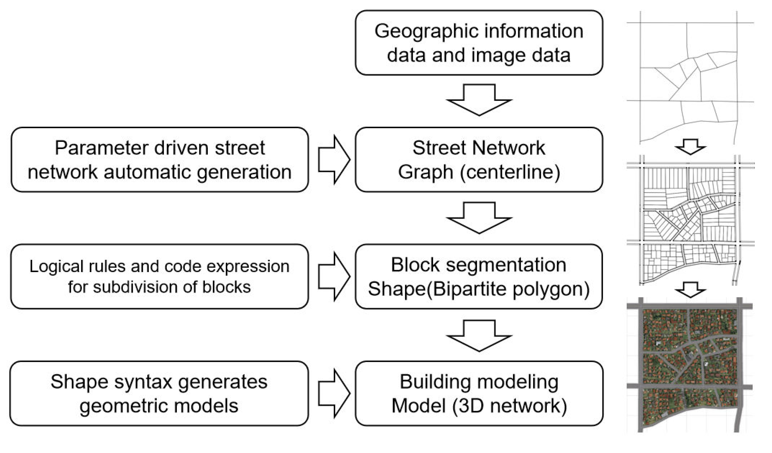
Parametric design technology operates on a computer software platform, and CityEngine has been chosen for this research. As a software compatible with Python programming, CityEngine can effectively address complex issues in traditional village spatial forms through secondary development. Its seamless integration with ArcGIS allows for rapid modeling using GIS data, making it particularly advantageous for large-scale 3D form modeling [55,56]. The parametric design process in CityEngine follows a sequence: establishing the street network, segmenting blocks, modeling buildings, and creating detailed scenes. Through associative rules, CityEngine can dynamically adjust various objects within the model [57].
Figure 1.
CityEngine workflow diagram.
2.3. Research Ideas
Employing data technology, this study confronts the protection and development challenges of traditional Chinese villages with a focus on spatial analysis and reconstruction. Spatial analysis involves separately identifying the roads, blocks, and buildings that constitute the characteristic elements of traditional village space, and transforming optimized feature points into parameters and rules. Spatial reconstruction uses computer language algorithms to automatically generate spatial textures based on spatial feature data extraction and parameter analysis, facilitating the automatic reconstruction and weaving of traditional village spatial textures [58]. The logical framework of the research is detailed in Figure 2.
3. Extraction of Core Parameters of Spatial Characteristics in Traditional Chinese Villages
This section details the process of identifying and codifying the core parameters that define the spatial characteristics of traditional Chinese villages.
3.1. Spatial Feature Analysis
Spatial feature analysis involves converting spatial elements into quantifiable parameters and rules for descriptive analysis. This process includes two stages: quantitative analysis of spatial features and their parameterized translation. Initially, spatial features are deconstructed based on principles of spatial elements’ integrity, with basic elements of roads, blocks, and buildings being identified and separate parameter sets being constructed for each. These parameters are designed to independently represent and control specific features. Subsequently, algorithmic rules are developed to extract parameter values from spatial forms, translating them into computer-readable data linked to spatial elements through functions and equations, thus establishing constraint relationships.
3.2. Parameter Analysis and Extraction Rules of Road Spatial Features
A detailed analysis of the spatial characteristics of traditional village roads reveals the internal dynamics and functional traits of their morphological development. The parameterized analysis begins with preprocessing existing roads to identify and remove redundant information. Roads are then segmented into subgraph sets to isolate fundamental compositional elements, which are subsequently translated into parameters or rules. Algorithmic rules are formulated to extract parameter values from the existing terrain [58,59]. The effective parameters and extraction rules for road spatial features, as determined through experimentation, are presented in Table 1.
The illustrations for parameterized translation of road spatial features are as follows:
- The road network morphology can be summarized into three types: organic, raster, and radial. Complex road networks can be achieved through the superposition and fusion of these three types (Figure 3).
- The number of village centers refers to the number of public centers in the village, and the road density in the village center is often higher than that in the periphery (Figure 4).
- Figure 5 illustrates the spatial quantification feature for road length, road angle, and road intersections, where 02 represents road intersections, 04 represents road nodes, d1 represents distance between road intersections, θ represents the road intersection angle, and β represents the angle between roads.
3.3. Parameter Analysis and Extraction Rules for Spatial Features of Blocks
The organizational structure and planar morphology of blocks are crucial in shaping the spatial form of traditional villages. The parameterization analysis aims to delineate block divisions that reflect their functions and closely match actual property blocks. Blocks are decomposed into subgraphs, and their organizational and morphological characteristics are converted into parameters and rules [58]. Research and reconstruction experiments on traditional village block patterns have yielded specific parameter indicators and extraction rules, which are outlined in Table 2.
The illustrations of parameterized translation of block spatial features are as follows:
- The block subdivision forms have three types: recursive subdivide, offset subdivide and skeleton subdivide (Figure 6).
- Figure 7 illustrates the quantitative extraction method for block planar morphological features, where θ represents the block interior angle, L and W represent block boundary lines, and L’ represents the block direction line, which is a straight line parallel to the long side of the bounding rectangle outside the block.
3.4. Parameter Analysis and Extraction Rules of Building Space Features
The spatial characteristics of buildings are captured by translating their planar and facade form elements into parameters and rules. The established parameter indicators and corresponding extraction rules are detailed in Table 3.
The illustrations of parameterized translation of building spatial features are as follows:
- The patterns of building foundation shapes mainly include L-shaped, U-shaped, I-shaped, and combinations of these types (Figure 8).
- The building angle is the smaller angle between the building direction line and the reference line. Figure 9 illustrates the extraction rules for building angle.
- Figure 10 illustrates the extracted elements of building facade morphological features.
4. Parameterized Reconstruction and Practical Application of Traditional Village Space
This section outlines the process of parameterized reconstruction of traditional village space and its practical applications.
4.1. Parameterized Space Reconstruction
Parameterization technology, coupled with computer programming algorithms, enables the automatic generation of spatial textures that mimic original features, facilitating the reconstruction and weaving of traditional village textures. The reconstruction process is divided into two main parts: the organization of associated feature elements and the construction of visualization models.
4.1.1. Organization of Associated Feature Elements
Utilizing the CityEngine software platform’s generation module, a set of logical rules and code expressions are created to construct spatial "growth" within the constraints of space (dimensional and geometric) and organizational rules. The spatial form elements of roads, blocks, and buildings are arranged in a cohesive relationship model. Figure 11 illustrates this organization, where A, B, and C represent spatial types, a1, b1, and c1 represent the feature elements constituting spatial types, the lines between elements indicate constraint relationships, b31 signifies the conditions for constraining spatial elements, c23 denotes the conditions for constraining different spatial elements of the same type, and ab12 represents the constraint conditions for spatial elements between different types.
The spatial generation of roads is carried out through the StreetModule of the CE software platform, which decomposes the roads into five components: street, sidewalk, crossing, junction, and junctionentry. The components are organized in an orderly manner into a framework according to constraint conditions, and through the secondary development of CGA rule files, revise and optimize the generated road spatial form. Figure 12 illustrates the process of road space reconstruction.
The reconstruction of block space and building is mainly achieved through programming methods. By using the CGA language provided by CE and writing CGA rule files, spatial features and constraint relationships between features are integrated to form a spatial generation relationship model. Parameter values are substituted into the CGA file and imported into the CE platform for spatial generation. Figure 13 illustrates the process of block space and building reconstruction.
4.1.2. Visualization Model Construction
Employing the CityEngine software platform, visual models are constructed based on the overall linked relationship model. This is done using parameter-driven and relationship-driven mechanisms to create two-dimensional graphics and three-dimensional visualization images. These models simulate the generation of basic spatial features and serve as a foundation for the subsequent reconstruction of the traditional village space.
4.2. Practical Application of Parameterized Space Reconstruction
4.2.1. Research Area
Qiji Village, located in Yanggu County, Shandong Province, is recognized on the sixth list of traditional Chinese villages. As an important historical dock of the Grand Canal since the Yuan Dynasty, Qiji Village has been a prosperous trading hub. Its well-preserved ancient dock and connected commercial street are significant components of the Grand Canal’s World Heritage application, as shown in Figure 14a. However, with the decline of river transport, Qiji Village faces challenges such as depopulation, dilapidated buildings, and poor infrastructure, leading to the erosion of its social functions, cultural values, and spatial features. The study focuses on a 22-hectare area designated for the protection and renewal of Qiji Village, as shown in Figure 14b.
In the national spatial planning context, Qiji Village is within the urban development boundaries. The main challenge is integrating traditional village protection with urban construction, preserving spatial patterns and historical buildings, improving infrastructure, and enhancing the village’s vitality. This research aims to address these challenges.
4.2.2. Data Acquisition and Establishment of Parameter Sets
Data collection involves on-site research and the use of open-source geographic information to gather data on roads, land parcels, and buildings within the Qiji Village landscape protection area. This data serves as the foundation for generating renewed spatial morphological features. Following the earlier mentioned parameter analysis and extraction rules, the data is categorized, integrated, and current spatial feature parameter values are extracted. These values are optimized to reflect changes in urban development and residents’ needs, creating a traditional village spatial characteristic parameter database to support the automatic reconstruction of spatial styles (Figure 15).
4.2.3. Reconstruction and Continuation of Spatial Texture
Using the spatial feature parameter database, the study explores the automatic generation of traditional village spatial textures with the CityEngine software platform. The process begins with the application of traditional village boundary extraction rules, combined with the scope of traditional village protection planning and the construction area designated by national land space, to determine the areas requiring renewal. The road space form generation module is then used to generate the road network form by adjusting parameter values. The generated road form is further refined by importing rule files for secondary development (Figure 16a). Following this, block segmentation and block spatial texture reconstruction are performed through programming using the CGA rule language provided by CityEngine or compatible Python language (Figure 16b). Finally, parameterized 3D modeling of buildings is conducted using CGA syntax or rule files written in Python to generate and reconstruct the spatial texture of buildings (Figure 16c).
As demonstrated, parametric design can automatically generate planning schemes through programming with rule-based languages based on extracted parameter data. By adjusting parameter indicators, the automatically generated plans can be optimized and adaptively modified to reconstruct planning and design schemes that not only retain traditional village characteristics but also meet modern living needs. This alignment with traditional village protection and future development trends makes the planning and design process more rational and efficient.
5. Conclusions
Digital technology is increasingly applied to protect traditional settlements. Parameterization technology extracts the systematic rules governing the spatial information of traditional settlements, overcoming limitations such as potential biases and inaccuracies inherent in subjective methods of information transmission, and ensuring the accurate preservation of historical landscape information. By integrating advanced technologies and combining human and computer decision-making, planning schemes are generated that preserve the spatial characteristics of case studies while incorporating modern living needs. Digital technology promises to bring order and innovation to traditional spaces.
The digital generation of Qiji Village’s protection and development planning scheme validates the effectiveness and technical advantages of automatic generation methods based on the parameterization of spatial feature elements. Parametric design utilizes parameters and algorithms, with its rich and rigorous design logic, to improve design efficiency. This reflects the advantages of parametric design methods in terms of systematicity, interpretability, and controllability. Despite the diversity of traditional Chinese villages, their unique bottom-up growth pattern provides a recognizable and consistent basis for digital generative design techniques. With advancements in artificial intelligence and digital technology, and as spatial data on traditional villages becomes richer and more refined, data-driven automatic generation of planning and design schemes will increasingly address the complex challenges of protecting and renewing traditional settlements and historical buildings.
6. Discussion
6.1. Play the Important Role of Planners in Computer Aided Planning and Design
One important purpose of computer-aided planning and design is to gradually move towards intelligent systems that alleviate human workload and ensure that the process remains human-centric. It transforms design principles into intelligent rules and hands them over to computers, freeing more human energy into design decisions and forming a human-machine interactive planning and design process. Any planning and design scheme is almost never carried out on a blank sheet of paper. The current situation or existing constraints themselves are important base map information for planning and design. In addition, the manual preset of key design intentions is also an important factor in determining the outcome of the scheme, which is a work scope that computers cannot automatically complete. The interpretation of existing conditions, the addition of manual presets, and computer-aided generation form a reciprocating relationship: on the one hand, the results generated through computer-aided generation provide situational feedback for existing conditions and manual presets, triggering rethinking and re judgment of existing conditions and manual presets. On the other hand, for the results generated through assisted generation, human intelligence needs to be deeply involved in screening, evaluating, and adjusting, ultimately transforming them into design solutions guided by the thinking of planners. During the adjustment process, the barriers between planners and computers are broken to the greatest extent possible, and a traceable and iterative interaction form is established. Human intelligence and role become the top priority in the computer-aided process.
6.2. Building Effective Application Methods and Approaches
Transforming research results into understandable planning languages is an important aspect of parametric design application transformation. The specific application forms include planning and design guidelines, graphic language, and control indicators. One approach is to transform core parameters and related rules describing spatial texture characteristics into planning and design guidelines. For example, in traditional building updates, the building height should be given a reasonable interval range as an important guidance. The second approach involves expressing the rules and parameters in graphical language, with the CityEngine software exporting the simulated traditional village protection planning scheme as JPG or vector graphics, and using the data exchange function between CityEngine software and ArcGIS system to build a geographic information database. The third approach is to convert the parameters into control indicators for traditional village protection and renewal, guiding the design and evaluation of the completed planning plan, such as road density and building area.
The specific application approaches can be considered from the aspects of planning, design, evaluation, and management. One is to guide the conceptual design of the overall spatial form of traditional villages, promote planning to respect and explore the original spatial features of the village in terms of concept and cognition, explore the internal organic connection with traditional spatial features, and thus enable the design scheme to better integrate with the original village space. The second is to guide the detailed plan for the protection and renewal of traditional villages. The study breaks down the village’s spatial style into subdivided spatial constituent elements, achieving parameterized control of each constituent element. It can accurately guide the planning and design of the micro spatial form of villages. The third is to quantitatively evaluate the planning and design scheme, analyze the planning scheme, extract corresponding parameter values, compare and analyze them with specific parameters in research results, judge the differences and values of characteristic parameters based on planning demands, evaluate the planning scheme, and propose suggestions for scheme adjustment. The fourth is to finely manage the renewal behavior of traditional villages. Unplanned construction can easily result in spatial textures that deviate from the original style. Parameterized research results can provide personalized and detailed construction guidance suggestions for different plots and specific buildings, achieving refined management and avoiding the occurrence of extreme texture forms. The fifth is to optimize village planning technology. Parametric planning has advantages in data, visualization, and dynamism. By generating three-dimensional visualization models, it increases the readability of the planning process and the dynamism of the planning.
6.3. Limitations and Prospects of Research
6.3.1. Improving the Extraction Method of Spatial Features and Organizational Rules
The traditional parameterization method is mainly based on human settings. If designers intervene excessively in the design process, the resulting designs may lack true intelligence and automation, and it is difficult to get rid of the dependence on subjective factors of humans. Therefore, in future research, parameterized planning and design methods will also be combined with other data mining tools to jointly extract rules. In recent years, breakthroughs have been made in the research of artificial intelligence assisted planning and design. Through machine learning of a large number of real cases, case features are extracted, enabling the recognition and extraction of villages’ spatial forms with strong locality and adaptability [60,61,62]. This approach minimizes manual intervention in the generation process and addresses the issue of manually selecting generation rules and adjusting parameters in parametric design methods. Integrating the advantages of parametric design methods in systematicity, interpretability, and controllability with the advantages of deep learning methods in feature perception, a computer-aided form design framework combining parametric design and deep learning is constructed to accurately perceive and recognize complex spatial forms, intelligently assist in generating spatial form schemes, and accurately simulate and deduce the schemes in real-time.
6.3.2. Multidimensional Optimization Parameterized Content System
There are many parameters that affect and control the generation of village spatial texture. Although guided by static indicators and capable of generating spatial plans, traditional village protection is a complex task that involves the inherent mechanism of multi-scale space, with more diverse humanistic and social content. It is necessary to consider a range of objectives, encompassing both objective constraints, such as land rights and heritage conservation, and subjective factors, such as culture, social systems, economy, and aesthetics. These issues require further study in subsequent artificial intelligence model development, aiming for their effective integration into parameterized planning through parameter values and reconstruction rules. Analyzing the relationship between parametric design methods and the cultural characteristics of rural areas, although human behavior patterns and socio-economic factors play an important role in shaping space, the subjectivity of space itself cannot be ignored. It is necessary to "spatially" consider social and economic development, human demands, sociocultural and institutional structures. This concept can provide a feasible approach for incorporating "invisible" indicators into the parametric design process, build a more comprehensive parameterized indicator system.
6.3.3. Application of Planning and Design Considering Traditional Village Differentiation
Although the sample traditional villages selected in this article have certain representativeness, in reality, the development and evolution of Chinese traditional villages are influenced by natural geographical environment, social and cultural circle layer, and socio-economic development processes, resulting in traditional village types with obvious spatial differences and distinct regional characteristics. The research results of this article cannot be directly applied to all types of traditional villages, but their principles are the same. By adjusting the parameters and rules according to the characteristics of the research object, based on the research in this article, they can be applied. Additionally, the construction of a national database detailing the morphological characteristics of traditional villages would be beneficial. Clustering algorithms could then be employed to classify traditional villages, identify common and differential features between them, better understand the semantics and spatial characteristics of traditional villages, and provide technical support for parametric design to promote the centralized and contiguous protection and utilization of traditional villages.
6.3.4. The Construction of Efficient Public Participation Platform
Protecting traditional villages involves more than just spatial conservation and the restoration of historical buildings; it requires coordinating multiple stakeholders, particularly ensuring active participation by villagers as primary guardians [63]. The planning and design ideas proposed in this article may face numerous management challenges when implemented in practice. Particularly after decentralization, the high threshold for participation and associated costs can significantly reduce planning efficiency. In daily village management, there may be many contradictions, greatly increasing management costs. The dynamic, interconnected, and visually accessible nature of parameterization technology offers a cost-effective and efficient path for participatory planning. The framework proposed in this study can facilitate the villagers’ comprehension of the plan and allow them to provide feedback on their interests, and enhances the possibility of multi-stakeholder involvement in the protection process.
In contemplating the role of technology in planning, it is worth considering whether computer-aided planning and design have inadvertently given precedence to technology over other aspects. Does intelligent tool thinking weaken the dominant position of humanism in creative thinking? As the French philosopher Bernard Stiegler once said, “We need to create a new technological culture to respond to the era of technology” [64]. Therefore, under new technological conditions, we need to consider how to reshape spatial planning and design under human-machine symbiosis.
Author Contributions
Conceptualization, Yong Fan; methodology, Yong Fan; software, Xuan Li, Yong Fan; validation, Xuan Li, Yong Fan; formal analysis, Yong Fan; investigation, Yong Fan, Xuan Li, Wen-jie Xiao; resources, Yong Fan, Xuan Li; data curation, Yong Fan, Xuan Li, Wen-jie Xiao; writing—original draft preparation, Yong Fan; writing—review & editing, Di Wang; visualization, Yong Fan, Xuan Li; supervision, Di Wang; project administration, Yong Fan, Di Wang. All authors have read and agreed to the published version of the manuscript.
Funding
This research was funded by the Ministry of Education of the People’s Republic of China: 21YJCZH024 and the People’s Government of Shandong Province: ZR2021ME226.
Data Availability Statement
The processed data used to support the findings of this study have not been made available because the data is part of ongoing research.
Acknowledgments
We would like to express our gratitude to the editor and reviewers for their valuable comments.
Conflicts of Interest
The authors declare no conflicts of interest.
References
- Wen Quan; Tang Jianguo; Cai Kuangyuan. The Authenticity and Integrity of Traditional Village Protection from the Perspective of Vernacular Built Heritage: A Case Study of Three Gorges Original Township Hankuimen. Huazhong Architecture. 2023, 41, 143–147. [Google Scholar]
- He Ziyi; Liu Juan; Tan Jiaxing; Gao Chaoxuan. Research on Digital Protection and Inheritance of Traditional Villages Based on the Whole Life Cycle. Development of Small Cities & Towns. 2023, 41, 46–52. [Google Scholar]
- Cai Jun; Wen Rigiang; Jiang Wei; Yan Jiao; Lu Lifuan. DeepLabV3+ Improved Algorithm for National Building Recognition in Traditional Village Aerial Images. Bulletin of Surveying and Mapping. 2023, 04, 49–53. [Google Scholar]
- Wu Ning; Wen Tianrong; Tong Lei. Research On Application Of Parametric Analysis And Reconstruction In Village Space Exemplified By A Traditional Village In Guizhou. Architecture & Culture. 2016, 05, 142–143. [Google Scholar]
- Qin Qiaohua; Xiao Dawei; Luo Mingnan; Tao Jin. A Study on the classification of traditional village images based on convolutional neural network. City Planning Review. 2020, 44, 52–58. [Google Scholar]
- Yueping Kong; Peng Xue; Yuqian Xu; Xiaolong Li. An Environmental Pattern Recognition Method for Traditional Chinese Settlements Using Deep Learning. Applied Sciences. 2023, 13, 4778. [Google Scholar] [CrossRef]
- Dai Jianhua; Peng Ruoyao; Xu Lu; et al. A Survey of Information Extraction Based on Deep Neural Networks. Journal of Southwest China Normal University (Natural Science Edition. 2022, 4, 1–11. [Google Scholar]
- RUSSAKOVSKY O; DENG J; SU H; et al. ImageNet large Scale Visual Recognition Challenge. International Journal of Computer Vision. 2015, 3, 211–252. [Google Scholar]
- Quan Steven Jige; Park James; et al. Artificial intelligence-aided design: Smart Design for sustainable city development. Environment and Planning B: Urban Analytics and City Science. 2019, 46, 1581–1599. [Google Scholar]
- Xiao Liu; Xu Feng; Wang Jun. Preliminary Studies on Parametric Design of New Hutong Space:A Case Study on Qianmen District in Beijing. Huazhong Architecture. 2013, 31, 35–39. [Google Scholar]
- SMELIK R M; TUTENEL T; IDARRA R. A Survey on Procedural Modelling for Virtual Worlds. Computer Graphics Forum. 2014, 33, 31–50. [Google Scholar] [CrossRef]
- Xiong Lu; ZHANG Hongxia; LEND Tianxiang. Exploration of the Urban Design Modeling Through Parametric Shape Grammar: The Generation of Waterfront Space of Liangnan Watertown. New Architecture. 2018, 04, 24–27. [Google Scholar]
- TANG Peng; Ll Hongjian; WANG Xiao; Ludger Hovestadt. Generative Design on Conservation and inheritance of Traditional Architecture and setlement Based on Machine leaming: A case study on the Urban Renewal Design of Roma Termini Railway Station]. The Architect. 2019, 01, 100–105.
- Luo Y; He J; He Y. A rule-based city modeling method for supporting district protective planning. Sustainable Cities and Society. 2017, 28, 277–286. [Google Scholar] [CrossRef]
- Chen Y; Feng M. Urban form simulation in 3D based on cellular automata and building objects generation. Building and Environment. 2022, 226, 109727. [Google Scholar] [CrossRef]
- Zhang M; Wu J; Liu Y; Zhang J; Li G. GIS Based Procedural Modeling in 3D Urban Design. International Journal of Geo-Information. 2022, 11, 531.
- Pérez-Martínez I; Martínez-Rojas M; Soto-Hidalgo JM. A methodology for urban planning generation: A novel approach based on generative design. Engineering Applications of Artificial Intelligence. 2023, 124, 106609. [Google Scholar] [CrossRef]
- Wang X, Song Y, Tang P. Generative urban design using shape grammar and block morphological analysis. Frontiers of Architectural Research. 2020, 9, 914–924. [Google Scholar] [CrossRef]
- PARISH Y I H; MULLER P. Procedural Modeling of cities. Siggraph 2001 Conference Proceedings. 2001, 301–308. [Google Scholar]
- LIPP M; SCHERZER D; WONKA P; et al. Interactive Modeling of City Layouts using Layers of Procedural Content. Computer Graphics Forum, 2011, 30, 345–354. [Google Scholar] [CrossRef]
- GALIN E; PEYTAVIE A; MARECHAL N; ,et al. Procedural Generation of Roads. Computer Graphics Forum, 2010, 29, 429–438. [Google Scholar] [CrossRef]
- FERNANDES G D; FERNANDES A R. Space Colonisation for Procedural Road Generation. Space Colonisation for Procedural Road Generation. 2018 1st International Conference on Graphics and Interaction (Icgi 2018), 2018.
- Wang H; Wu Y; Han X; , Xu M; Chen W. Automatic generation of large-scale 3D road networks based on GIS data. Computers & Graphics. 2021, 96, 71–81. [Google Scholar]
- BENES J; WILKIE A; KRIVANEK J. Procedural Modelling of Urban Road Networks. Computer Graphics Forum. 2014, 33, 132–142. [Google Scholar] [CrossRef]
- GARCIA-DORADO I; ALIAGA D G; UKKUSURI S V. Designing large-scale interactive traffic animations for urban modeling. Computer Graphics Forum. 2014, 33, 411–420. [Google Scholar] [CrossRef]
- WATSON B; MÜLLER P; VERYOVKA O; et al. Procedural Urban Modeling in Practice. IEEE Computer Graphics and Applications. 2008, 28, 18–26. [Google Scholar] [CrossRef]
- MULLER P; WONKA P; HAEGLER S; et al. Procedural modeling of buildings. Acm Transactions on Graphics. 2006, 25, 614–623. [Google Scholar] [CrossRef]
- FANG Zhou; ZHENG Shuwen; ZHAO Liang. Perceptual Recognition, Generative Modeling, and Virtual Simulation of Urban Form Using Deep Learning. World Architecture. 2023, 07, 78–84. [Google Scholar]
- ZHANG K H; ZHANG N; QUAN F M; et al. Digital Form Generation of Heritage in Historical District Based on Plan Typology and Shape Grammar: A Case Study on Kulangsu Islet. Buildings. 2023, 13. [Google Scholar]
- WANG J; ZHAO B L; FAN W; et al. A Combined Shape Grammar and Housing-Space Demand Approach: Customized Mass Housing Design in Rural Areas of the North China Plain. Nexus Network Journal. 2022, 24, 5–23. [Google Scholar] [CrossRef]
- VANEGAS C A; GARCIA-DORADO I; ALIAGA D G; et al. Inverse Design of Urban Procedural Models. Acm Transactions on Graphics. 2012, 31. [Google Scholar]
- Martin I; Patow G. Ruleset-rewriting for procedural modeling of buildings. Computers & Graphics. 2019, 84, 93–102. [Google Scholar]
- Sugianto E; Hosea JF; Jabar BA; Irwansyah E; Fitrianah D. 3D Modelling Building of District Johar Baru Using ArcGIS Pro and CityEngine. Procedia Computer Science, 2023, 227, 623–631. [Google Scholar] [CrossRef]
- SUN Cheng; QU Dagang; HUANG Xi. Towards Al-Architect Interactive and Collaborative Architectural Design: A Case Study of intelligent stylization of Building shape. Architectural Journal. 2020, 02, 74–78. [Google Scholar]
- Lin Wenqiang. Research on Automatic Generation of Primary School schoolyard Layout Based on Deep Learning. Master, South China University of Technology, Guangzhou, 2020.
- Yingtao Qi; Yulin Ren; Dian Zhou; Yupeng Wang; Yujia Liu; Bin Zhang. Quantitative Analysis and Cause Exploration of Architectural Feature Changes in a Traditional Chinese Village: Lingquan Village, Heyang County, Shaanxi Province. Land. 2023, 12. [Google Scholar]
- Zhe Li; Si Huang; Han Wang; Yan Li. Digital Analysis of the Water Layout Ecological Wisdom in Traditional Chinese Rural Settlements: A Case Study of Liukeng Village in Jiangxi Province. Journal of Resources and Ecology. 2022, 13, 371–381. [Google Scholar]
- Shen Yinlan; Yan Xingchen; Yu Piyong; Liu Hui; Wu Guofang; He Wei. Seismic Resistance of Timber Frames with Mud and Stone Infill Walls in a Chinese Traditional Village Dwelling. Buildings. 2021, 11, 580–580. [Google Scholar] [CrossRef]
- Yang Simin; Yi Lina; Guan Hui; Li Yong. A meme-based approach for knowledge mining, organization, and presentation of traditional Chinese settlement culture. Heritage Science. 2023, 11. [Google Scholar]
- Zhongyi Nie; Chen Chen; Wei Pan; Tian Dong. Exploring the Dynamic Cultural Driving Factors Underlying the Regional Spatial Pattern of Chinese Traditional Villages. Buildings. 2023, 13. [Google Scholar]
- Liu Xuedong; Huang Yi; Xiang Huilin; Zhang Chen; Chen Juan; Xiao Dawei. Optimization strategies for the management mechanisms of conservation and utilization in traditional Chinese villages based on relevance analyses of performance evaluation. Journal of Asian Architecture and Building Engineering. 2023, 22, 1699–1713. [Google Scholar] [CrossRef]
- Xu Luyao; Shi Lei; Wang Xin; Wan Yuliang; Fan Zhuo. Can tourists become disciples? The formation and mechanism of place conversion in traditional Chinese villages. Frontiers in Psychology. 2023, 14, 1301127–1301127.
- Xiaolong Hu; Tong Yao. Study on the Synergistic Development of Chinese Traditional Villages Protection and Landscape Development. Applied Mathematics and Nonlinear Sciences. 2024, 9. [Google Scholar]
- Jialu, Li. Community Building: An Exploration of the Path in Traditional Village Conservation and Renewal with an Example of Yim Tin Tze in Hong Kong. Journal of Environmental and Agricultural Studies. 2022, 3, 01–06. [Google Scholar]
- Yufei Lyu; Lei Zhang; Xin Liu; Xuan Ma. Microclimate-Adaptive Morphological Parametric Design of Streets and Alleys in Traditional Villages. Buildings. 2024, 14, 152. [Google Scholar] [CrossRef]
- WANG Liangliang; LU Yaru; HUANG Wencan; HAN Jie. Analysis Methods for Landscapes and Features of Traditional Villages Based on Digital Technology: Taking Xiaocuo Village in Quanzhou as an Example. Chinese Landscape Architecture, 2023, 39, 13–19. [Google Scholar]
- Yang, Xi. Advances in Quantitative Research Methodologies for the Spatial Layout of Rural Settlement in Recent 20 Years. Urban Planning International. 2020, 35, 72–80. [Google Scholar]
- Lin Kefeng; Tao Wei; Gu Hengyu. Spatial form and spatial cognition of traditional villages based on space syntax: A case study of jiaju Village, Guizhou Province. Scientia Geographica Sinica, 2023, 43, 1608–1618. [Google Scholar]
- SUN Li; ZHOU Yifan; SUN Xuepu; WANG Ting; YANG Zhen. Spatial Syntax Analysis of Traditional Villages Based on Space Syntax: A Case Study of Linggong Village in Beijing. Journal of Beijing University of Civil Engineering and Architecture. 2023, 39, 1–9. [Google Scholar]
- Xu Weiguo; Xu Feng. Architectural Creation and Thinking of the Parametric Design in China: Interview with Professor Xu Weiguo & Xu Feng of School of Architecture of Tsinghua University. Urbanism and Architecture. 2010, 6, 108–113. [Google Scholar]
- Chi Zhi-wei; Chen Jie; Zhang De-shun. Process in Application of Parametric Design and Its Inspiration to Landscape Design. Chinese Landscape Architecture. 2012, 28, 40–45. [Google Scholar]
- Patrik Schumacher. Parametric Patterns. Architectural Design. 2009, 6, 28–41. [Google Scholar]
- LI Xiaojun; Huang Jian; Zou Fu. Rapid Three-Dimension and Spatial Analysis for Village Planning Scheme. Journal of Geomatics. 2021, 46, 178–181. [Google Scholar]
- Li Hengkai; Li Xiaolong; Li Zivang; Chen Yueving. Three-dimensional modeling method of Hakka ancient village based on component model library-a case study in the BaiLu ancient village. Science of Surveying and Mapping. 2019, 44, 182–189. [Google Scholar]
- Zhang Hui; Liu Chao; Li Yan; Wang Youjie. Research on 3D Building Modeling Technology Based on CityEngine. Bulletin of Surveying and Mapping. 2014, 11, 108–112. [Google Scholar]
- Duarte J P; Rocha J; Ducla-Soares G; et al. An urban grammar for the Medina of Marrakech; Springer: Berlin, Germany, 2006; pp. 483–502. [Google Scholar]
- Zhou Ling. Method of 3D Modeling for Digital City Based on Parametric Technology. Master, Zhe Jiang University, Hang Zhou, 2013.
- Tong Lei. Parametric Analysis and Reconstruction of Villages’ Spatial Texture and Its Planning Application Research. Dr, Zhe Jiang University, Hang Zhou, 2016.
- Wu Meihan. Research on Parametric Analysis and Planning Application of Village Space Texture in Qin and Han New Towns. Master, Chang’an University, Xi’an, 2022.
- Han Qing; Yin Chao; Deng Yunyuan; Liu Peilin. Towards Classification of Architectural Styles of Chinese Traditional Settlements Using Deep Learning: A Dataset, a New Framework, and Its Interpretability. Remote Sensing. 2022, 14, 5250–5250. [Google Scholar] [CrossRef]
- Quan Steven Jige. . Urban-GAN: An artificial intelligence-aided computation system for plural urban design. Environment and Planning B: Urban Analytics and City Science. 2022, 49, 2500–2515. [Google Scholar]
- Yang Junyan, Zhu Xiao, Sun Haocheng. Research on artificial intelligence urban design method based on the combination of deep learning and characteristic parameters: taking the formation of urban multi-type building community as an example. Contemporary Architecture. 2022, 06, 33–36. [Google Scholar]
- Xu Yubin; Li Bin. Rural Renewal Process under the Cooperation of Research Team and Villagers: A Case Study of the Traditional Village L. Modern Urban Research. 2023, 02, 127–132. [Google Scholar]
- Kouppanou Anna. Bernard Stiegler’s Philosophy of Technology: Invention, Decision, and Education in Times of Digitization. Educational Philosophy and Theory. 2015, 47, 1110–1123. [Google Scholar] [CrossRef]
Figure 2.
The logical framework of the research.
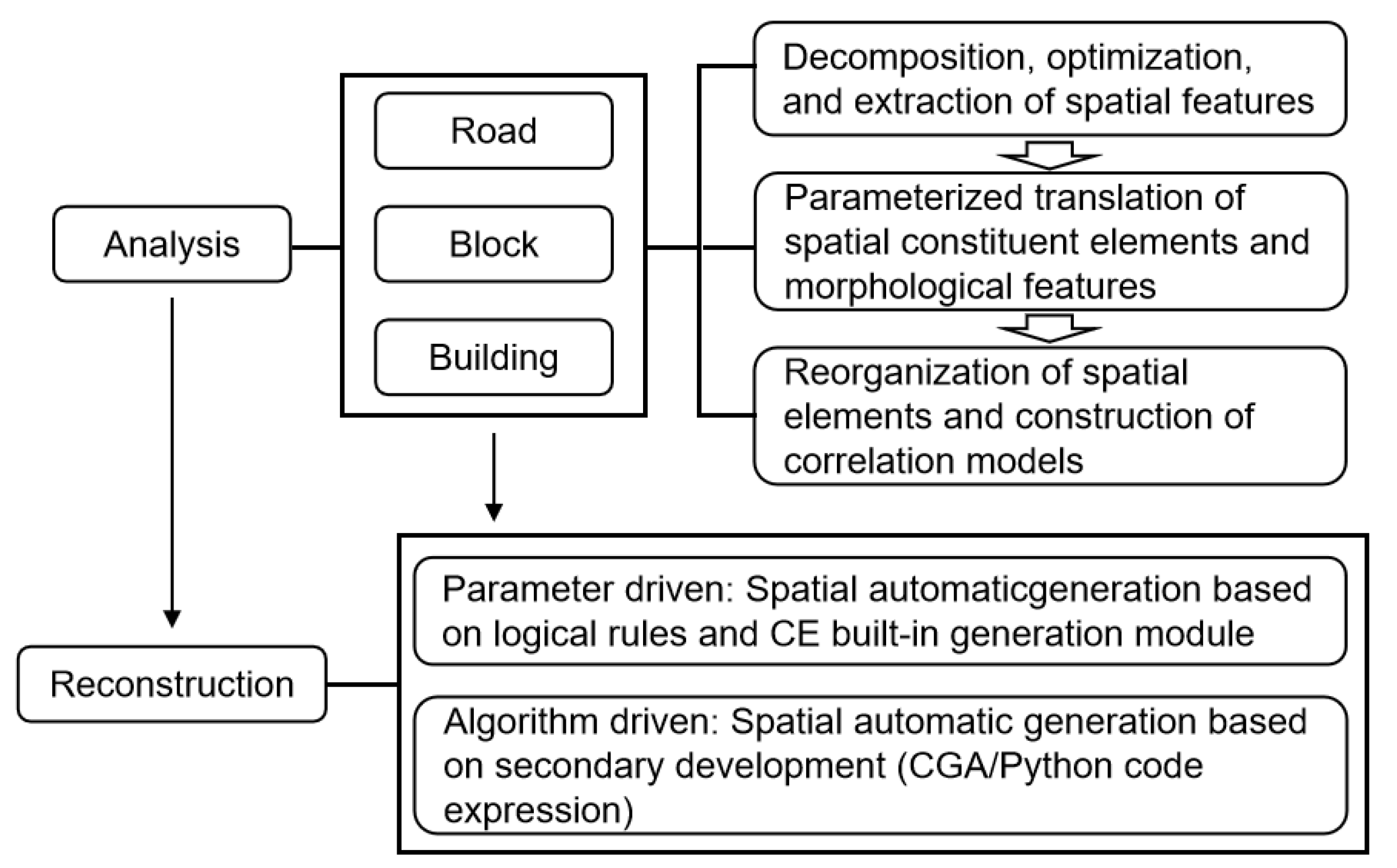
Figure 3.
Three basic road network forms.

Figure 4.
Schematic diagram of village centers (a single center and two centers).
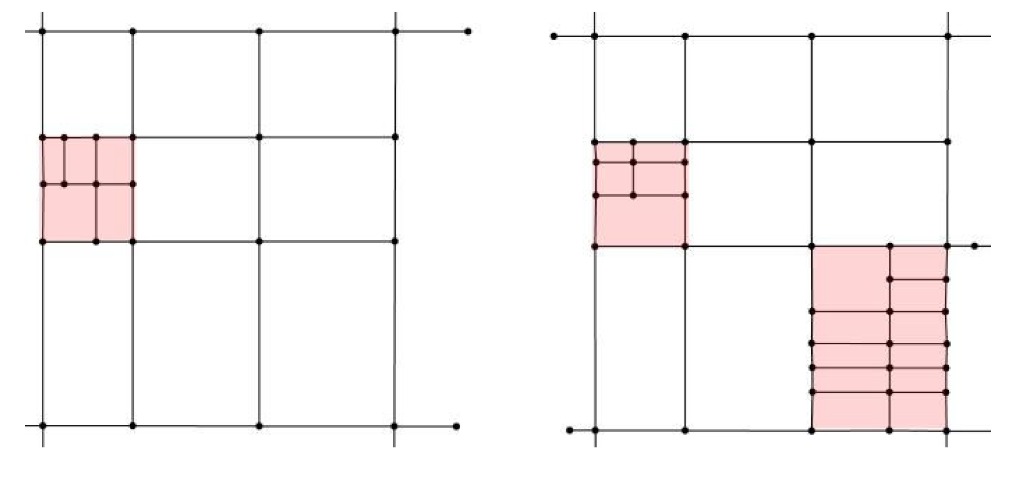
Figure 5.
Schematic diagram of parameter extraction for road length, angle, and nodes.
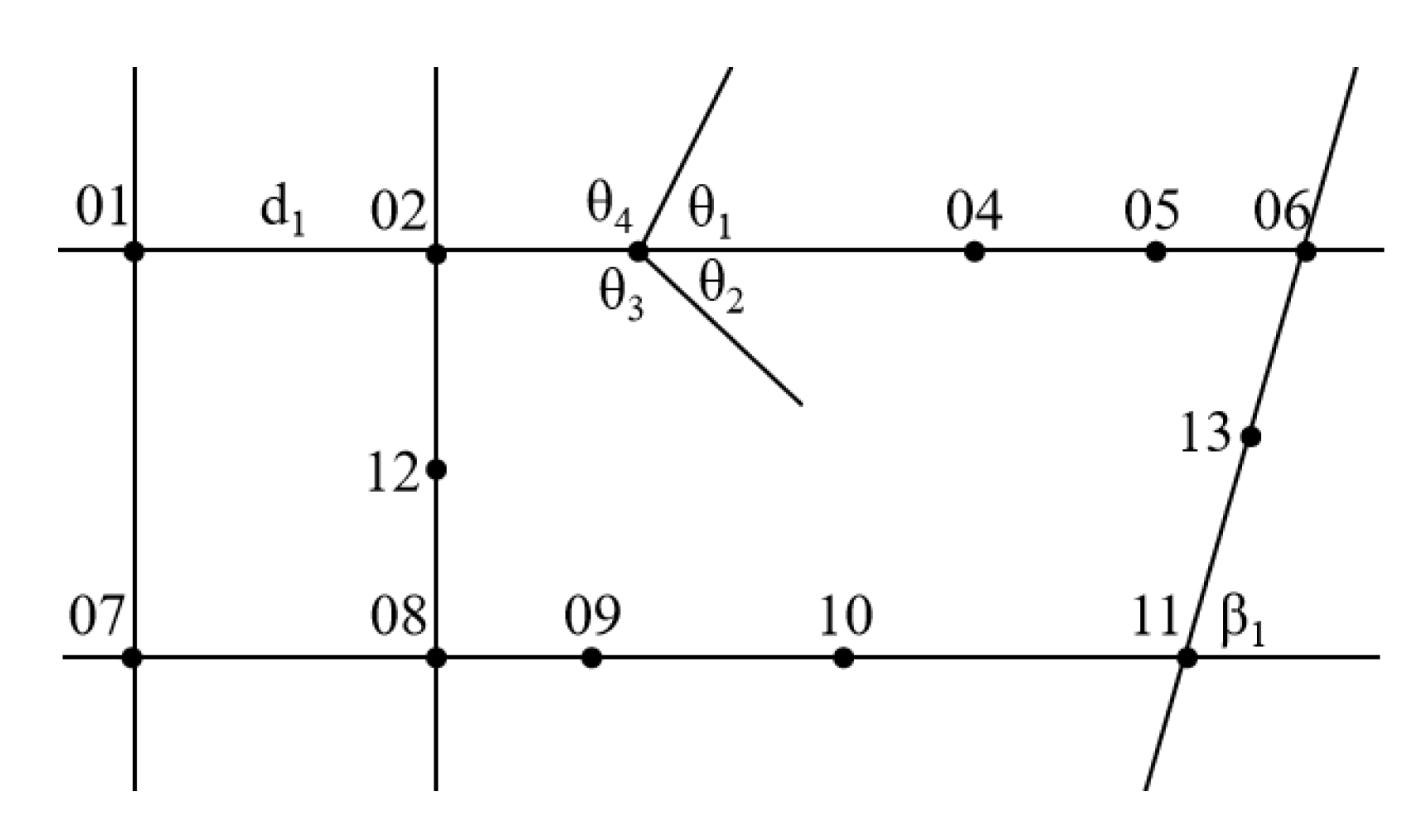
Figure 6.
Three types of block subdivision forms.
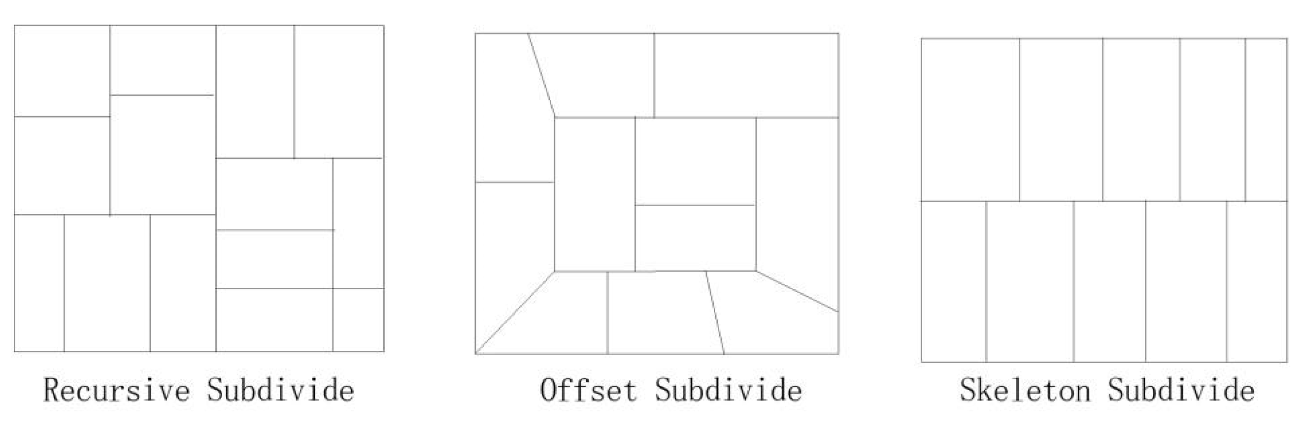
Figure 7.
Schematic diagram of block planar morphological features.
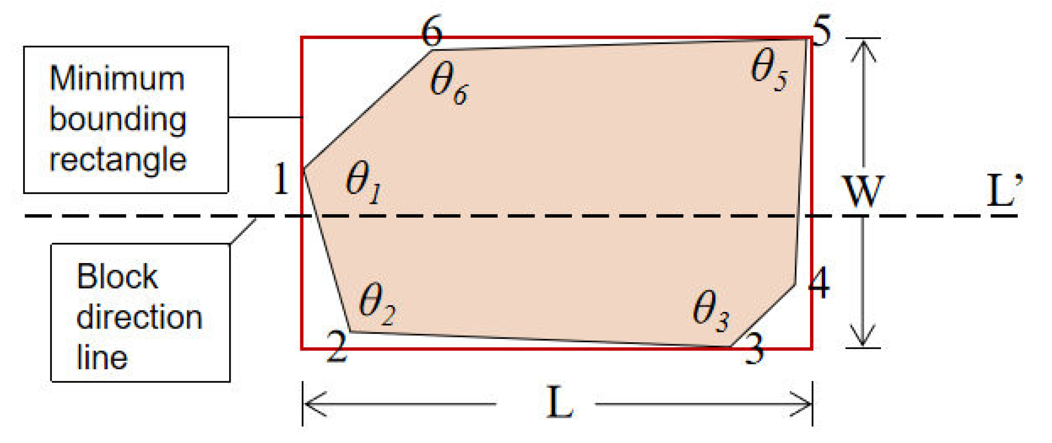
Figure 8.
Schematic diagram for extracting the building foundation shape.
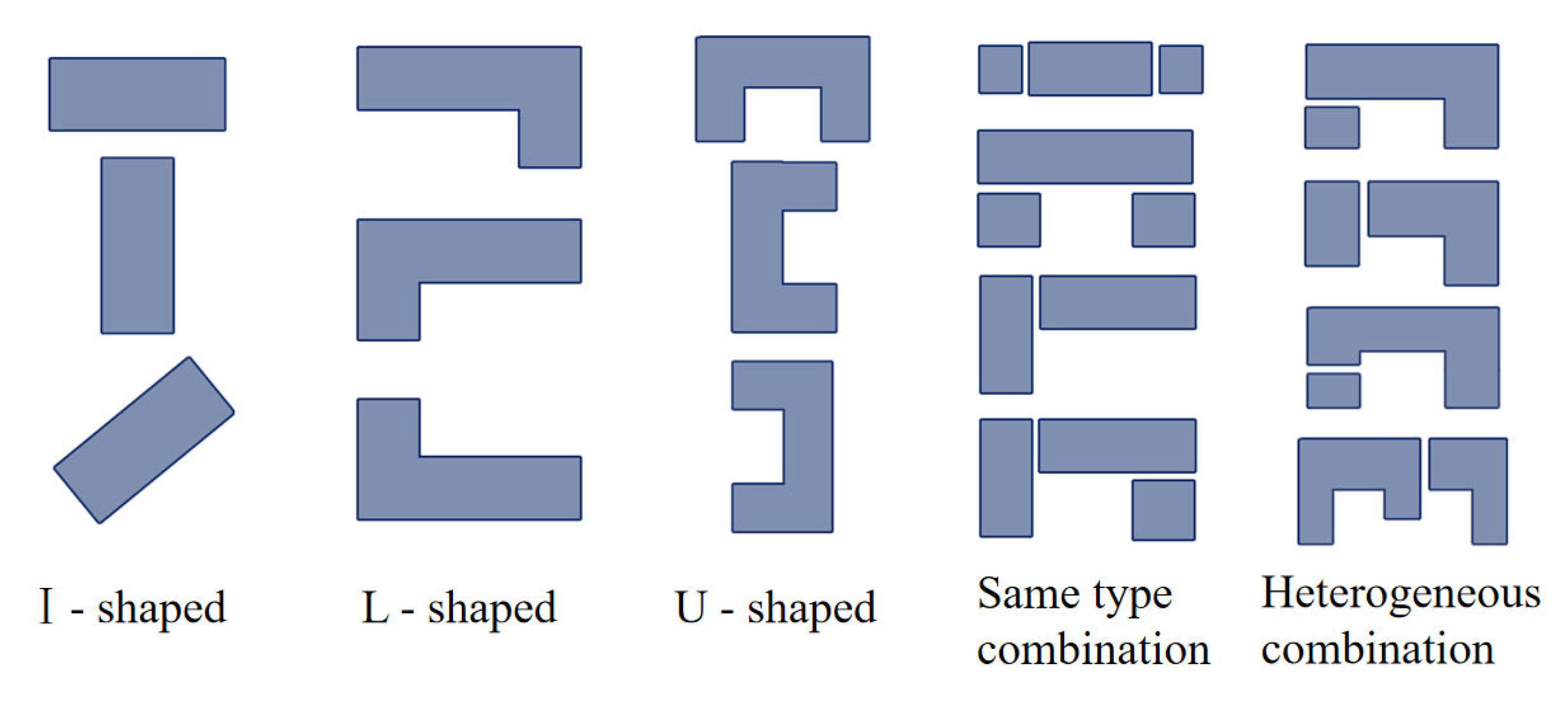
Figure 9.
Schematic diagram for extracting building angle parameter.
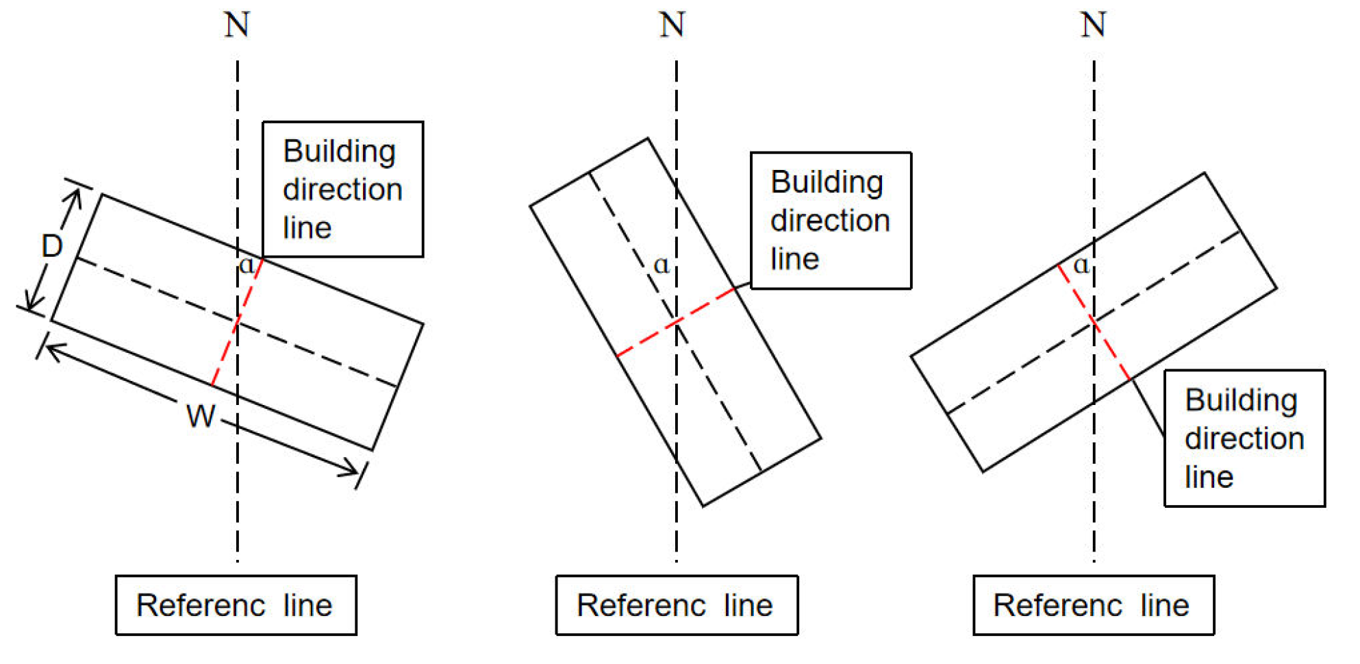
Figure 10.
Extracted elements of building facade morphological features.
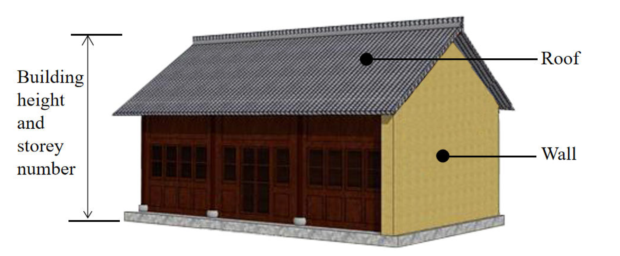
Figure 11.
Spatial feature element relationship model.
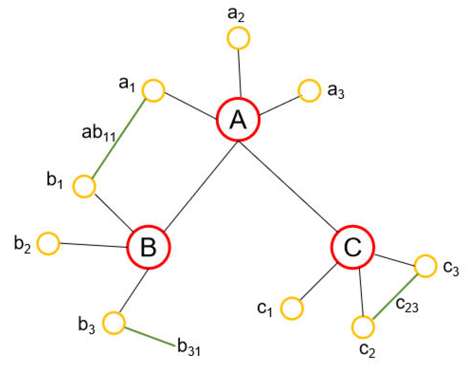
Figure 12.
The process of road space reconstruction.
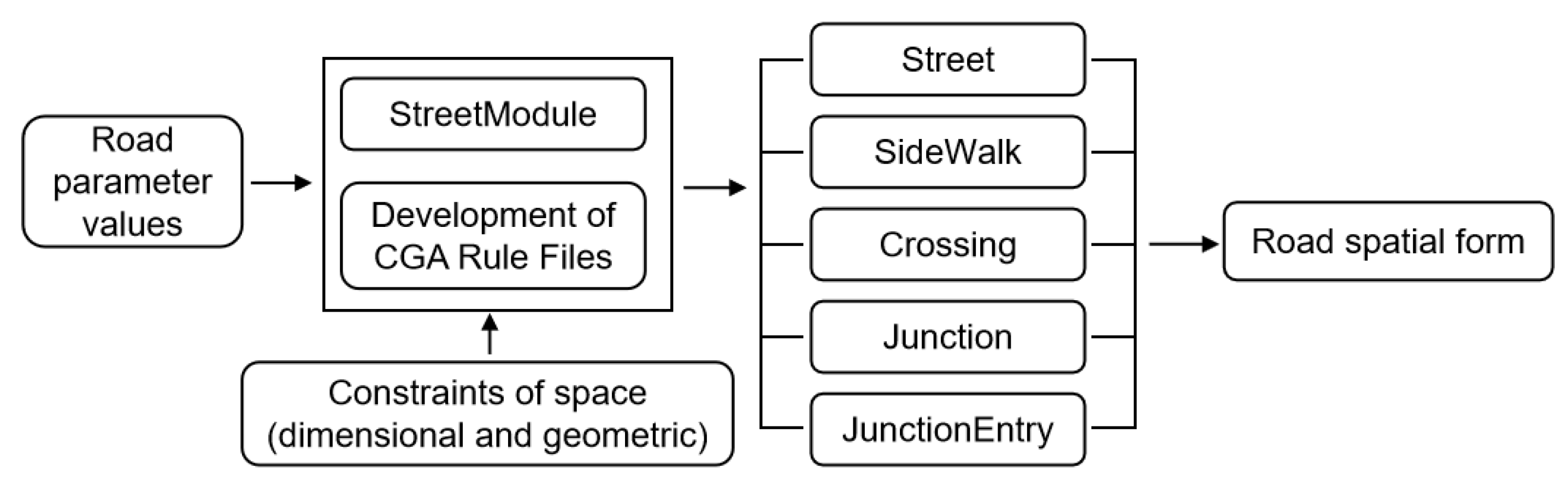
Figure 13.
The process of block space and building reconstruction.
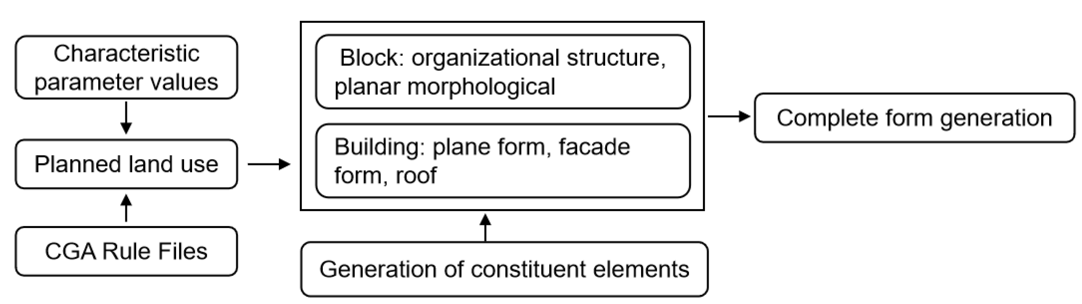
Figure 14.
(a) Current situation map of Qiji Village; (b) Study area range.
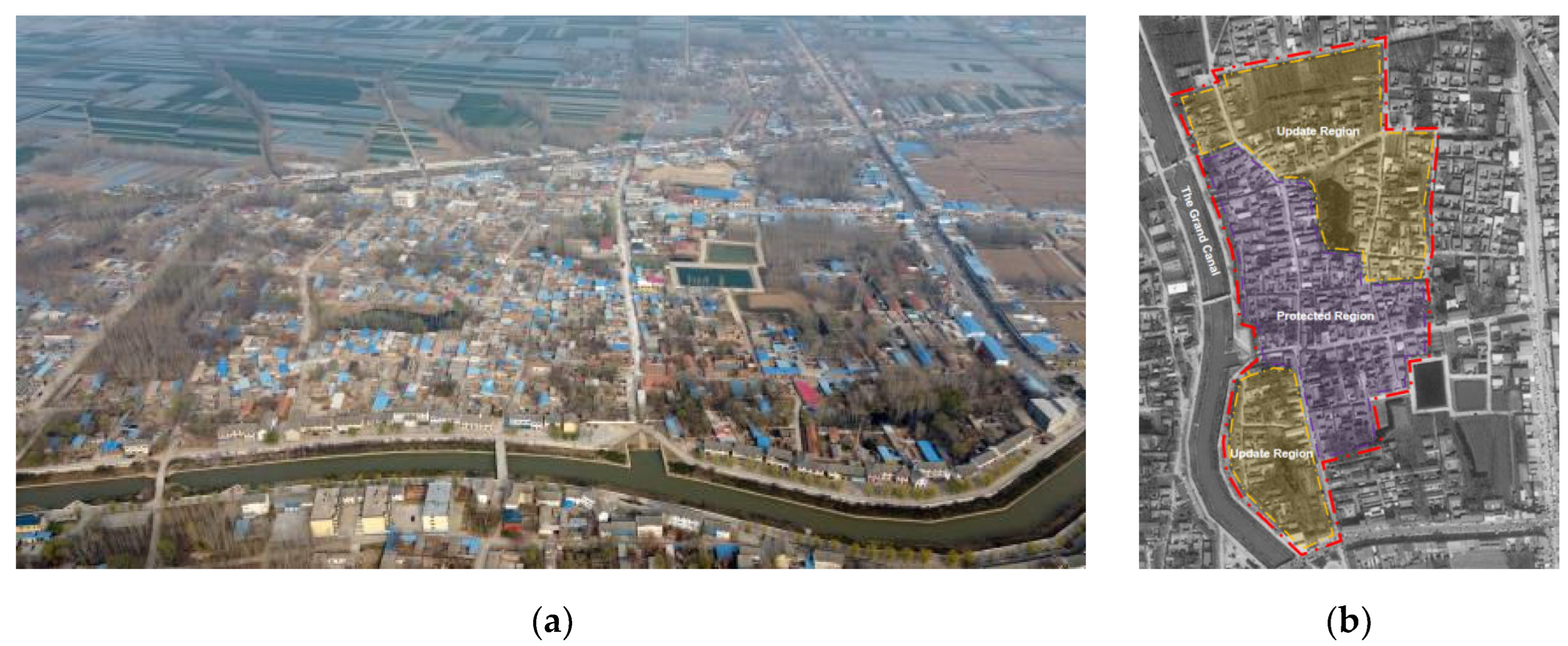
Figure 15.
Feature extraction of spatial characteristics.
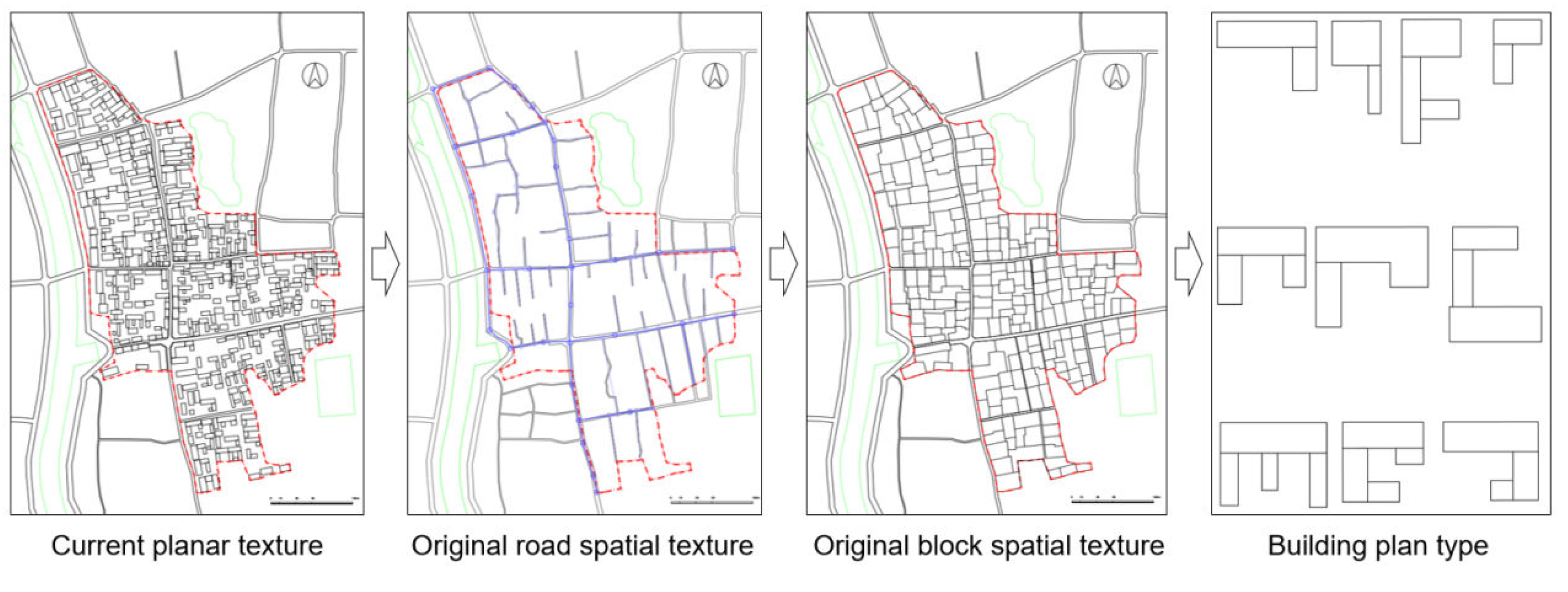
Figure 16.
(a) Parameterized automatic generation of the road network; (b) Parameterized automatic generation of the block segmentation; (c) Parameterized automatic generation of the building layout.
Figure 16.
(a) Parameterized automatic generation of the road network; (b) Parameterized automatic generation of the block segmentation; (c) Parameterized automatic generation of the building layout.
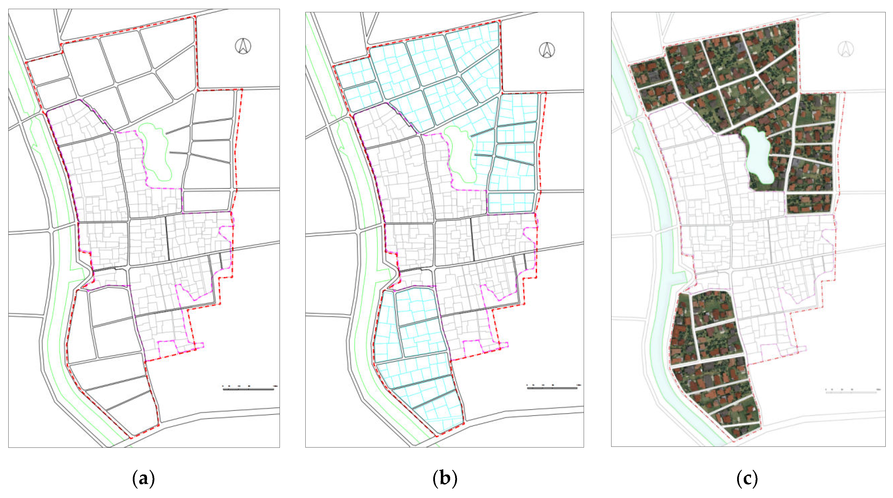

Table 1.
Road spatial features parameters and extraction algorithms.
| Classification | Form | Parameter | Extraction Algorithm |
|---|---|---|---|
| Overall morphological characteristics of roads | Road network morphology | Road network morphology mode | Extract characteristics based on the current road network |
| Number of village centers | Based on on-site research and experience judgment | ||
| Number of roads | Number of road sections | The number of sections of a single road | |
| Road intersection | Minimum distance between road intersections |
f(IntersectionsDiatanceMin)=Min(d1,d2,d3...dn); d represent the shortest road distance between road network intersections |
|
| Intersection ratio |
R=Nr/Ni Nr represent number of road nodes Ni represent number of intersection nodes |
||
| Minimum angle of intersection |
f(MinAngle)=Min(θ1,θ2,θ3...θn); θ represent minimum value of intersection angle |
||
| Road deflection angle | Maximum deviation angle of the road |
f(MaxDeflectionAngle)=Max(β1,β2,β3...βn); β represent the maximum value of the minimum angle set between adjacent two sections of road |
|
| Characteristics of Road Plane Morphology | Road length | Long road length(lrl) |
lave=Average(l1,l2,l3...ln) f(lrl)=Average(la1,la2,la3...lan),among them lan>lave f(srl)=Average(lb1,lb2,lb3...lbn),among them lbn<lave |
| Shorter road length(srl) | |||
| Elastic interval of longer road length (elrl) | f(elrl)=[│max(la1,la2,...lan)-f(lrl)│+│min(la1,la2,...lan)-f(lrl)│]/2 | ||
| Elastic interval of shorter road length (esrl) | f(esrl)=[│max(lb1,lb2,lb3...lbn)-f(srl)│+│min(lb1,lb2,lb3...lbn)-f(srl)│]/2 | ||
| Road width | Main road width (mrw) | f(mrw)=Average(wm1,wm2,wm3...wmn) | |
| secondary road width (srw) | f(srw)=Average(ws1,ws2,ws3...wsn) | ||
| Elastic range of main road width (emrw) | f(emrw)=[│max(wm1,wm2,wm3...wmn)-f(mrw)│+│min(wm1,wm2,wm3...wmn)-f(mrw)│]/2 | ||
| Elastic range of secondary road width (esrw) | f(esrw)=[│max(ws1,ws2,ws3...wsn)-f(srw)│+│min(ws1,ws2,ws3...wsn)-f(srw)│]/2 | ||
| Vertical morphological characteristics of roads | Road elevation | Road elevation max | f(RoadElevationMax)=Max[Elevation(e1,e2,e3...en)] |
| Road elevation min | f(RoadElevationMin)=Min[Elevation(e1,e2,e3...en)] | ||
| Road elevation average | f(RoadElevationAverage)=Ave[Elevation(e1,e2,e3...en)] | ||
| Elastic range of road elevation | f(eere)=[│emax-eave│+│emin-eave│]/2 | ||
| Road slope | Slope range | f(SlopeRange)=[Smax,Smin] |
Table 2.
Blocks spatial feature parameters and extraction algorithms.
| Classification | Form | Parameter | Extraction Algorithm |
|---|---|---|---|
| Organizational structure characteristics | Cluster form | Block subdivision form |
f(SubdivideType)=Recursive Subdivide; f(SubdivideType)=Offset Subdivide; f(SubdivideType)=Skeleton Subdivide; |
| Subdivision type ratio | a1%,a2%,a3%, a1+a2+a3=100 | ||
| Block density | Maximum block density | f(DensityMax)=Max(a1,a2,a3,...an) | |
| Minimum block density | f(DensityMin)=Min(a1,a2,a3,...an) | ||
| Average block density | f(DensityAverage)=Average(a1,a2,a3,...an) | ||
| Block direction | Maximum block direction | f(DirectionMax)=Max(β1,β2,β3,...βn) | |
| Minimum block direction | f(DirectionMin)=Min(β1,β2,β3,...βn) | ||
| Average block direction | f(DirectionAverage)=Average(β1,β2,β3,...βn) | ||
| Terrain adaptation methods | Terrain adaptation methods | f(LotAlignment)={Uneven,Minmum,Maxmum,Average} | |
| Functional blocks number ratio | Functional blocks number ratio | a1%,a2%,a3...an%, a1+a2+a3+...an=100 | |
| Block interface density | Block interface density | ,Ri represent the length of the base on one side of the boundary of the i-th building adjacent to the block; L is the length of the block boundary | |
| Planar morphological features | Block area | Maximum block area | f(AreaMax)=Max[area(a1,a2,a3,...an)] |
| Minimum block area | f(AreaMin)=Min[area(a1,a2,a3,...an)] | ||
| Average block area | f(AreaAverage)=Average[area(a1,a2,a3,...an)] | ||
| The interval size and probability distribution of block area | f[AreaFrequency(i-j)]=Frequency(date_arry,bin_arry) | ||
| Block boundary line | The longest side length of the bounding rectangle on the block | f(EdgeLongest)=Max(l1,l2,l3,...ln) | |
| The shortest side length of the bounding rectangle of the block | f(EdgeShortest)=Min(l1,l2,l3,...ln) | ||
| The average side length of the bounding rectangle of the block | f(EdgeAverage)=Average(l1,l2,l3,...ln) | ||
| The maximum length-width ratio of bounding rectangle outside the block | f(MaxtLength/Width ratio)=Max(a1,a2,a3,...an) | ||
| The minimum length-width ratio of bounding rectangle outside the block | f(MintLength/Width ratio)=Min(a1,a2,a3,...an) | ||
| The average length-width ratio of bounding rectangle outside the block | f(AverageLength/Width ratio)=Average(a1,a2,a3,...an) | ||
| Block interior angle | Maximum block interior angle | f(CoenerAngleMax)=Max(θ1,θ2,θ3,...θn) | |
| Minimum block interior angle | f(CoenerAngleMim)=Min(θ1,θ2,θ3,...θn) | ||
| Average block interior angle | f(CoenerAngleAverage)=Average(θ1,θ2,θ3,...θn) |
Table 3.
Buildings spatial feature parameters and extraction algorithms.
| Classification | Form | Parameter | Extraction Algorithm |
|---|---|---|---|
| Characteristics of building plane form | Building foundation | Building foundation shape | Using typological methods to extract the shape of building plans |
| Scale of building foundation shape | s1%,s2%,s3...sn.%, s1+s2+s3+...sn=100,sn% represent the ratio of the number of n-th type building plans to the total number of buildings | ||
| Building width | Maximum building width | f(BuildingWidthMax)=Max(w1,w2,w3,...wn) | |
| Minimum building width | f(BuildingWidthMin)=Min(w1,w2,w3,...wn) | ||
| Average building width | f(BuildingWidthAverage)=Average(w1,w2,w3,...wn) | ||
| Building depth | Maximum building depth | f(BuildingDepthMax)=Max(d1,d2,d3,...dn) | |
| Minimum building depth | f(BuildingDepthMin)=Min(d1,d2,d3,...dn)) | ||
| Average building depth | f(BuildingDepthAverage)=Average(d1,d2,d3,...dn)) | ||
| Building area | Maximum building area | f(BuildingShapeAreaMax)=Max[area(a1,a2,a3,...an)] | |
| Minimum building area | f(BuildingShapeAreaMin)=Min[area(a1,a2,a3,...an)] | ||
| Average building area | f(BuildingShapeAreaAverage)=Average[area(a1,a2,a3,...an)] | ||
| Concentrated distribution range of building area | f[BuildingShapeArea(i-j)]=Frequency(date_arry,bin_arry) | ||
| Characteristics of building facade form | Building height | Maximum building height | f(BuildingHeightMax)=Max(β1,β2,β3,...βn) |
| Minimum building height | f(BuildingHeightMin)=Min(β1,β2,β3,...βn) | ||
| Average building height | f(BuildingHeightAverage)=Average(β1,β2,β3,...βn) | ||
| Concentrated distribution range of building height | f[BuildingHeight(i-j)]=Frequency(date_arry,bin_arry) | ||
| Building storey number | Building storey number | s1%,s2%,s3...sn.%, s1+s2+s3+...sn=100,sn% represent the proportion of floors in the n-th type of building | |
| Building direction | Maximum building direction | f(BuildingDirectionMax)=Max(β1,β2,β3,...βn) | |
| Minimum building direction | f(BuildingDirectionMin)=Min(β1,β2,β3,...βn) | ||
| Average building direction | f(BuildingDirectionAverage)=Average(β1,β2,β3,...βn) | ||
| Concentrated distribution range of building direction | f[BuildingDirection(i-j)]=Frequency(date_arry,bin_arry) | ||
| Roof | Roof style | b1%,b2%,b3...bn.%, b1+b2+b3+...bn=100,bn% represent the proportion of the n-th type of roof form | |
| Roof material | c1%,c2%,c3...cn.%, c1+c2+c3+...cn=100,cn% represent the proportion of the n-th type roof material | ||
| Wall | Building wall material | d1%,d2%,d3...dn.%, d1+d2+d3+...dn=100,dn% represent the proportion of the n-th type of building wall material |
Disclaimer/Publisher’s Note: The statements, opinions and data contained in all publications are solely those of the individual author(s) and contributor(s) and not of MDPI and/or the editor(s). MDPI and/or the editor(s) disclaim responsibility for any injury to people or property resulting from any ideas, methods, instructions or products referred to in the content. |
© 2024 by the authors. Licensee MDPI, Basel, Switzerland. This article is an open access article distributed under the terms and conditions of the Creative Commons Attribution (CC BY) license (http://creativecommons.org/licenses/by/4.0/).
Copyright: This open access article is published under a Creative Commons CC BY 4.0 license, which permit the free download, distribution, and reuse, provided that the author and preprint are cited in any reuse.


