Submitted:
21 March 2024
Posted:
22 March 2024
You are already at the latest version
Abstract
This study employs Geographic Information System (GIS) techniques to evaluate the walkability of Onaizah City, which serves as a representative model for a Saudi city situated in the Qassim region, north of the capital city, Riyadh. The goal is to evaluate how easily pedestrians can navigate the street network and identify areas that excel or need improvement in terms of walkability. The results offer insights for planning and development supporting sustainable initiatives. Approach; The study involves integrating GIS data, such as street layouts, land use patterns, and demographic information. By analyzing factors like integration values and choice values within the street network the study gauges’ walkability aspects. Furthermore, correlation analysis explores how spatial arrangements, influence walkability. By studying the case of a medium-sized Saudi city, which can then be applied to several Saudi cities. Cost distance analysis and cost-back correlation calculations are employed to determine pedestrian routes. Findings and Discussion; Through GIS techniques the study effectively assesses the walkability of Onaizah City by identifying three walking paths with lengths of (1401m, 1283m, and 1507m). The study reveals pedestrians' actual city distance. Weighted criteria assign 40% to heritage sites, 30% to green spaces, and 15% each to mosques/commercial sites. Preserving access to heritage sites and incorporating areas enhance walkability. Conclusion: Study enhances walkability understanding, offering data-driven planning suggestions. Urban planners prioritize pedestrian connectivity, considering GIS effectiveness and physical environment importance. Findings support walkability research and sustainable urban development.
Keywords:
Spatial Configuration
; Pedestrian Movement
; Accessibility
; walkability
; Urban Design and Planning
; Onaizah City
1. Introduction
The rapid urbanization and population growth experienced by Saudi Arabian cities in recent decades have brought about significant changes in their city forms and underscored the need for creating sustainable and walkable urban environments. The increase in urbanization rates has led to the expansion of cities and the emergence of new challenges Kingdom Vision 2030 related to transportation, accessibility, and quality of life. As a response to these challenges, there has been a growing interest in examining the walkability of urban areas, with a particular focus on street networks and their impact on pedestrian movement and accessibility. Walkability refers to the extent to which an urban environment is conducive to walking and pedestrian activities. It encompasses various attributes such as the design and layout of streets, the presence of sidewalks and crosswalks, the availability of amenities and services within walking distance, and the overall safety and comfort of pedestrians. Walkable cities not only promote physical activity and healthier lifestyles but also foster social interactions, reduce reliance on private vehicles, and contribute to environmental sustainability.
In the context of Saudi Arabia, Onaizah city situated in the heart of the country, has experienced significant urban growth in recent years. As the city expands, it becomes crucial to understand the walkability of its street network and identify opportunities to enhance pedestrian accessibility and mobility. The examination of Onaizah street network through the GIS techniques provides a comprehensive framework for analyzing the spatial configuration and accessibility of its streets.
GIS is a powerful tool that provides spatial data analysis tools and techniques. It provides tools and methods to capture, store, analyze, manage, and present geographic data. With GIS various spatial analysis tasks such as overlaying maps, identifying patterns, measuring distances, conducting proximity analysis, performing spatial statistics, and creating visualizations can be performed [1]. These capabilities make GIS valuable in a wide range of fields, including urban planning, environmental management, transportation, agriculture, and emergency response, among others. It enables the integration and visualization of various data layers, such as street networks, land use, amenities, and socio-demographic information, allowing for a comprehensive assessment of walkability factors. GIS helps quantify and map different aspects of the urban environment, facilitating evidence-based decision-making in urban planning and design. The objective of this study is to examine the accessibility of the street network in Onaizah City for walking using GIS techniques. By analyzing the spatial configuration of the street network and integrating it with relevant socio-demographic and land-use data, this research aims to identify areas of strengths and weaknesses in terms of walkability and pedestrian accessibility. The findings will provide valuable insights for urban planners, policymakers, and stakeholders to enhance the walkability and livability of Onaizah City. This paper is structured as follows: the next section provides a comprehensive literature review on the concepts of walkability and GIS applications in urban analysis. Subsequently, the methodology section outlines the data collection process, analysis techniques, and variables considered in the study [2]. The results section presents the findings and analysis of the walkable street network in Onaizah City, highlighting key patterns and trends. Finally, the conclusion section summarizes the main findings, discusses their implications, and offers recommendations for future research and urban planning interventions.
2. Research Methodology
The research aims:
The research aims to achieve the following objectives:
Examine the accessibility of the street network in Onaizah City as a model for Saudi a medium-sized Saudi city. The primary goal of the study is to assess the level of accessibility provided by the street network. This involves analyzing the layout, connectivity, and spatial configuration of streets to understand how they facilitate or hinder pedestrian movement and accessibility within the city.
Identify areas of strengths and weaknesses in walkability Through the analysis of the street network and the integration of relevant data layers, the study aims to identify areas within Onaizah City that exhibit high levels of walkability and areas that require improvement. By identifying strengths and weaknesses, urban planners and policymakers can prioritize interventions and improvements to enhance pedestrian accessibility and mobility.
Provide insights for urban planning and design: The research aims to offer valuable insights and recommendations for urban planners, policymakers, and stakeholders involved in the development and design of Onaizah City. The findings can inform decision-making processes and assist in formulating strategies to create more walkable and livable urban environments in the different Saudi cities.
Overall, the research aims to contribute to the understanding of walkability, accessibility and provide evidence-based recommendations for urban planning and design, and contribute to the broader discourse on sustainable urban development.
Problemdefinition:
The problem at hand is the lack of pedestrian-friendly infrastructure and inadequate connectivity in the street network of Onaizah City as a model of the Saudi cities. This hinders pedestrian mobility and walkability, leading to reliance on private vehicles and reduced quality of life. Addressing these issues is crucial to creating a more accessible and pedestrian-friendly urban environment in Onaizah. This knowledge can subsequently be studied and applied to various cities across Saudi Arabia.
Research propositions and methodology:
- The integration of GIS methods will provide a comprehensive framework for assessing the accessibility of the street network in Onaizah City.
- Spatial configuration factors, such as street connectivity, network integration, will have a significant influence on walkability and accessibility.
- The analysis of walkability factors, including land use, activity, heritage assets, and human scale, using GIS tools will contribute to understanding the overall walkability.
The Literature Review: This study aims to examine walkable street networks and accessibility in Onaizah City, Saudi Arabia by using GIS analysis. Through an extensive literature review, the study will explore previous research on the topic, with a focus on the concept of walkability and its connection to urban design and planning. The review will encompass key aspects such as factors influencing walkable cities, pedestrian accessibility, mobility and GIS applications in urban analysis, and prior studies on walkability in Saudi Arabian cities [1]. This comprehensive review will establish a foundation for understanding the current landscape and identifying research gaps, while the analysis and synthesis of existing knowledge will contribute to the theoretical framework.
Theoretical approach: The theoretical approach of this study encompasses several key components. Firstly, data collection will play a crucial role, involving the gathering of diverse datasets from various sources such as local authorities, government agencies, and open data sources. These datasets will include street network data, land use information, socio-demographic data, and relevant GIS layers. Once the data is collected, an analysis will be conducted to examine the spatial configuration and connectivity of the street network in Onaizah. Through the measurement of integration values and choice values within the network, this analysis will provide valuable insights into the accessibility and walkability patterns of the city.
Conducting analytical study: The analytical study will use various methods to investigate and evaluate the walkability of Onaizah City. Firstly, correlation analysis will be conducted to examine the relationship between spatial configuration factors (integration and choice values) derived from analysis and walkability factors obtained from GIS analysis. This analysis aims to identify correlations, dependencies, and patterns between the characteristics of the street network and the overall walkability of the city as shown in Figure 1
Based on the findings from the analysis, the study will offer valuable insights into the walkable street network and urban mobility in Onaizah City. It will provide a comprehensive evaluation of the current state of walkability, highlighting strengths and areas for improvement. Drawing on evidence-based research, the study will conclude with practical recommendations for urban planners, policymakers, and stakeholders. These recommendations will aim to enhance pedestrian accessibility, promote sustainable urban design, and ultimately improve the overall walkability of Onaizah City. which can then be applied to most Saudi cities.
3. Literature Review
The idea of walkability and its relationship to metropolitan plan and arranging has acquired huge consideration lately. Various examinations have investigated the elements that add to walkable urban communities and their effect on common openness and versatility. This writing survey gives an outline of key ideas connected with walkability and GIS applications in the metropolitan examination, and past exploration on walkability in Saudi Arabia's urban areas [2,3].
Walkability is a multi-layered idea that includes different components of the fabricated climate. It is ordinarily characterized as the degree to which a metropolitan region helps stroll and person on foot exercises [4]. Key elements impacting walkability incorporate the plan and format of streets, the presence of walkways, crosswalks, and walker well-disposed framework, land use designs, admittance to conveniences and administrations, security, and solace. Walkable urban communities energize actual work, advance social collaborations, diminish dependence on confidential vehicles, and add to natural manageability [5].
The relationship between spatial configurations and human behavior within urban environments. It examines the connectivity and integration of street networks, buildings, and public spaces to understand how they shape pedestrian movement, social interactions, and the perception of space. This analysis provides insights into the spatial hierarchy, connectivity, and accessibility patterns within a city, enabling a deeper understanding of the walkability of urban environments.
Geographic Information System (GIS) plays a crucial role in assessing walkability factors by providing spatial data analysis tools and techniques [6,7]. GIS allows for the integration and visualization of various data layers, including street networks, land use, amenities, and socio-demographic information. By utilizing GIS analysis, a comprehensive assessment of walkability can be conducted, mapping and quantifying different aspects of the urban environment. This enables evidence-based decision-making in urban planning and design, providing valuable insights into improving walkability [8].
The movement of pedestrians within urban areas and the role of street networks in facilitating social interactions have been extensively studied using various analytical approaches. For example, researchers have conducted correlation analyses to understand pedestrian movement and predict future states of cities like Athens [9]. They have also employed regression analysis to evaluate the impact of environmental characteristics, such as land use and topography, on pedestrian density and walkability in specific settings like university campuses [10]. Moreover, studies have examined configurational centralities and the relationship between graphical measurements of street networks and observed movement patterns in cities like Copenhagen [6]. These research efforts underscore the importance of understanding pedestrian movement and the influence of street networks on walkability in urban environments.
A study by Jabbari et al [8] delved into the correlation between connectivity and pedestrian movement using Angular Segment Analysis by Metric Distance (ASAMeD) analysis [6,11].The assessment of the results was visualized through digital maps within GIS-based environments. The findings of these studies demonstrated a strong relationship between the ASAMeD analysis and pedestrian movement patterns. ASAMeD analysis aids in identifying potential streets that pedestrians utilize for walking [8].
This analysis involves calculating and analyzing factors such as travel distances, connectivity, and proximity to amenities. GIS analysis provides valuable insights into the accessibility of different areas and how they relate to pedestrian movement patterns, enabling evidence-based decision-making in urban planning and design [12,13,14].
In the study of cities, it is widely recognized that the layout of urban areas influences people's movement within them, helping us identify the most likely routes to be taken. Designers have utilized various methods and theories for planning, but it is important to also consider the insights provided by GIS analysis [10,15,16]. GIS analysis enables the exploration of spaces with diverse features and plays a crucial role in identifying and addressing design challenges.
The assessment of street network accessibility is often conducted in various research studies. For instance, Lamíqui. used a method to determine the accessibility of a street network and discovered that the layout of the urban grid can impact pedestrian flow [17]. Since this method primarily captures movement patterns influenced by the road network's topology, recent studies have incorporated GIS to provide additional data support. Numerous studies have evaluated street network accessibility by integrating GIS and analyzing it at various scales within the city [18,19].
Refrences [2,20] stated that Jiang was one of the pioneers in combining spatial analysis theory with GIS, showcasing its potential in analyzing urban road structures, predicting traffic flow, and modeling pedestrian behavior. Despite considerable research on pedestrian behavior, there is still a lack of studies exploring the relationship between pedestrian route choice and the built environment [7,21]. and Iida introduced the concept of elevation difference in axial lines within spatial analysis, enabling three-dimensional analysis of city form. Typically, spatial analysis evaluates the spatial organization of city plans on a two-dimensional plane. Therefore, further research is needed to integrate land slope and integration values to promote the creation of pedestrian-friendly streets.
The significance of measuring integration values and how they contribute to the understanding of morphological approaches and accessibility patterns in the street network [22]. These values can be used to predict activities in specific areas where the network is situated [9,16].
Urban social spaces are tangible and discursive entities that possess real and sensory qualities, shaped by the relationships within them [6,11]. They serve as social hubs where individuals gather to exchange thoughts and ideas. These spaces are commonly known as community centers, neighborhood associations, or community leagues, and offer various services such as education, social engagement, health facilities, cultural activities, and recreational opportunities. These services contribute to the overall well-being of the community [20].
Community hubs are crucial in creating social infrastructure and networks, addressing vulnerabilities, and meeting localized needs. By providing a platform for social interaction, these spaces enhance community cohesion and contribute to the social fabric of the locality [20,23].
Urban public spaces can be seen as social hubs that facilitate the exchange of ideas and foster community connections. They offer a wide range of services, promote cultural activities, and encourage social engagement to enhance community well-being [23,24].
The various terms and definitions used to describe urban public spaces emphasize their significance as social and cultural hubs. Whether referred to as plazas, piazzas, community hubs, or social hubs, these multi-purpose institutions play a vital role in creating social infrastructure, fostering community connections, and meeting localized needs [6,11].
Through the integration within a GIS framework, researchers can utilize quantitative tools to enhance the analysis of urban morphology [2,16].This integration allows for a more systematic and comprehensive examination of the correlation between street network connectivity, spatial configuration, land use patterns, and pedestrian movement. It enables the identification of crucial factors that contribute to walkability and aids in the development of evidence-based strategies for urban planning and design.
4. Theoretical Approach
The spatial analysis, GIS tools and techniques will be utilized for further analysis. The collected datasets will be integrated within the GIS environment, allowing for the assessment of various factors related to walkability. This analysis will involve mapping land use patterns, amenities, and socio-demographic variables to evaluate their impact on walkability. Through GIS analysis, the study will also identify areas within Onaizah City that demonstrate high or low walkability scores, providing insight into the overall walkability profile of the city [9,12].
4.1. Walkable Main Streets
Individuals of any age, from kids to seniors, take part in strolling as a piece of their everyday practice. Strolling is viewed as a practical and comprehensive method of transportation. Regarding the metropolitan plan, a "walkable street" ought to have closeness to different objections, be liberated from boundaries, guarantee well-being, and give a suitable passerby foundation [2,18]. Nonetheless, a few creators contend that metropolitan plan ought to likewise consider different parts of strolling that add to placemaking [26]. This incorporates establishing upscale and cosmopolitan walkable conditions that highlight beautiful design and fascinating retail. Such streets can draw in the upper-working class as well as improve the experiential characteristics of the streets [16,27].
Central avenues, specifically, are Streetly recognized as the clamoring center points of social and financial action inside urban communities [15,28].They ordinarily have a different exhibit of little retail foundations and guarantee helpful walker admittance to ordinary labor and products. Shopping on central avenues isn't just a functional movement yet additionally a wellspring of relaxation and diversion, adding to energetic and dynamic public spaces. In any case, since the 1970s, the ascent of shopping centers and other huge-scope retailers on the edges of urban communities, upheld via the vehicle-driven metropolitan turn of events, has presented a critical contest to private ventures in downtown areas, bringing about their downfall. Factors, for example, expanding vehicle possession, changing examples of financial trade through web-based shopping, and the inclination for shopping centers have additionally exacerbated the difficulties looked by central avenues.
4.2. Study Site
Onaizah City is a city located in Al-Qassim Central Region in Saudi Arabia. It is situated in the central part of the country and is approximately 320 kilometers northwest of the capital city, Riyadh. Onaizah is one of the major urban centers in the Qassim Province and serves as an important economic, cultural, and administrative hub in the region as shown in (Figure 2).
Onaizah has experienced significant urban growth and development in recent years, resulting in changes to its urban fabric and transportation infrastructure. This makes it an interesting study site for exploring walkability and the impact of street networks on pedestrian movement using GIS techniques. By examining the walkability of Onaizah's street networks, researchers can gain insights into the city's pedestrian infrastructure, connectivity, and the factors that contribute to a pedestrian-friendly environment. The city center of Onaizah serves as the central business district and focal point of commercial and social activities in the city. Located within the heart of Onaizah, the city center is characterized by a concentration of shops, restaurants, offices, and public amenities. The city center of Onaizah a diverse range of retail establishments, including local businesses as well as larger national and international chains. It is a bustling area where residents and visitors alike come to shop, dine, and socialize. The streets in the city center are busy and vibrant, with a mix of pedestrians and vehicles.
As a significant economic center, the city center of Onaizah also houses important administrative buildings, government offices, and financial institutions. It is a hub for commercial activities, attracting business professionals, entrepreneurs, and investors. The city center has well-developed infrastructure and amenities to accommodate the needs of residents and visitors. This may include public transportation options, pedestrian-friendly streets, parking facilities, public parks, and recreational spaces.
The city center of Onaizah, located within the Al-Qassim Central Region of Saudi Arabia, is currently experiencing rapid urban development and infrastructure growth. The increasing population has necessitated the expansion of cities in the region to cater to the needs of residents and provide modern amenities and services. The ongoing development of transportation networks, educational institutions, healthcare facilities, and commercial centers is reshaping the urban landscape, creating a dynamic and bustling hub of economic and social activities. These advancements not only improve the quality of life for residents but also attract investments and foster further economic growth. The Al-Qassim Central Region, with its evolving city center in Onaizah, is poised to become a thriving and vibrant center within Saudi Arabia
The figure showcases the location of various commercial centers, malls, buildings, and Parking within the city center of Onaizah.
4.3. The Main Factors Affecting City Walkability
Walkability in cities is usually affected by many factors. Some of them will be explained in the following: -
Accessibility: The ease of access to essential services such as transportation, shops, and amenities within walking distance [7,16].
Land use mix: The variety of land uses within a neighborhood, such as residential, commercial, and recreational, encourages walking and reduces the need for car travel [13,29,30].
Density: High residential density creates a critical mass of people walking, increasing the number of destinations and services available within walking distance [31].
Connectivity: The quality and density of the street network, including sidewalks and crosswalks, as well as the presence of parks and other green spaces, encourages walking [8,10].
Street design: Pedestrian-friendly Street design, including wide sidewalks, ample lighting, and crosswalks, encourages walking and increases safety [6,21,30,32].
Safety: The presence of traffic calming measures, such as speed bumps and rounded corners, reduces the risk of accidents and increases the safety of pedestrians [8,11].
These criteria can be used to generate a GIS-based walkability index for a city. The GIS technology can be used to map and analyze the various factors that contribute to walkability [4,6,10,30].This information can then be used to create a comprehensive walkability index that can help urban planners and policymakers identify areas for improvement and prioritize investments in walkable infrastructure [15].
The factors affecting walkability include proximity to (four main variables) which are heritage sites, green areas, commercial sites, and mosques [18,30] As shown in Figure 3. Other variables such as lighting, terrain, pedestrian safety, and other relevant factors were excluded because all streets are well-lighted, the area is nearly flat and there are no steep slopes, all streets in the study area are two lanes only with a sidewalk in both sides and finally, there is no crime recorded in the area.
4.4. Create a Walkability Index
The walkability index was generated using a Multi-Criteria approach in GIS environment [31]. This index then was used to generate a cost surface that represents the relative cost of traversing different areas in the city center. The cost surface can be created by assigning cost values to each cell in a raster grid based on the criteria defined in the previous paragraph [4,34]. To create a cost surface for determining a walking path in the city center, the following methodology was used, which involves creating a distance raster, ranking the distance on a scale from 1 to 10, weighting the variables using the Analytical Hierarchy Process (AHP) method, and generating the cost surface using weighted overlay analysis [3].
The methodology can be breakdown into the following steps:
4.4.1. Create a Distance Raster
Create a distance raster that represents the distance from each cell in the study area to the desired variable [31]. The distance raster grids to the four study variables are shown in the following Figure 4
The map shows a depiction of the city center of Onaizah, Saudi Arabia. It displays various landmarks, including heritage sites, green areas, commercial sites, and mosques (This is the data used to analyze walkability).
These maps show the proximity to the various variables affecting the walkability in the study area which are heritage sites, green areas, commercial sites, and mosques.
4.4.2. Rank the Distance
Once the distance raster grids were generated, the distance values were ranked on a scale from 1 to 10, where 10 represents the highest cost value or locations that less attractive for walkability [13,31]. The ranked raster grids are shown in the following Figure 5
The figure illustrates ranked distance grids around walkability criteria in the city center of Onaizah, Saudi Arabia. These grids provide a visual representation of walkability index according to each variable used in the study.
4.4.3. Weight the Variables
The AHP method was applied to assign weights to the variables that were identified. AHP is a decision-making technique that helps determine the relative importance of different criteria [14,32,35]. By assigning weights to the variables, that reflect their importance in the overall cost calculation. As shown in Table 1.
These weights indicate the relative importance of each criterion in the overall cost calculation for walkability. Heritage sites hold the highest importance with a weight of 40.0%, followed by green areas with a weight of 30.0%. Mosques and commercial sites have equal weights of 15.0%. These weights suggest that in the context of walkability, heritage sites are considered the most significant criterion, followed by the presence of green areas. Mosques and commercial sites hold relatively lower importance, according to the pairwise comparisons and the AHP method used in the study. These weightings can guide decision-making processes and resource allocation strategies aimed at enhancing walkability by prioritizing actions and investments based on the relative importance of each criterion.
5.4.4. Generate the Walkability Index
the objective was to generate a walkability index using the ranked distance values and weighted variables. To accomplish this, a weighted overlay analysis was employed [36]. Weighted overlay analysis combines the input rasters, applies the assigned weights to each criterion, and generates an output raster representing the walkability index. The walkability index provides insights into the relative ease associated with walking in different areas of the city center, taking into account the defined criteria [19].
It serves as a visual representation of the varying levels of walkability based on the assigned weights and ranked distances. Figure 6 shows the walkability index in the study area on a scale of 1 to 8 and uses a color gradient or shading scheme, where different colors represent varying levels of walkability. Areas represented with high numbers and darker or more intense colors indicate greater challenges or barriers to pedestrian movement [18]. Conversely, areas with a lower number are represented with lighter or less intense colors, suggesting more favorable conditions for walking.
4.5. Find the Walking Path
Using the walkability index and applying the least cost path technique which starts with calculating the cost distance and cost backlink grids, the least cost path from the starting point to the destination can be calculated as shown in Figure 7 and Table 2 This path represents the most cost-effective route based on the defined criteria [16,28].
5. Finding and Discussion
The present study aimed to explore walkability in Onaizah City, as a model of the Saudi cities, by utilizing GIS techniques on street networks. The findings of this research shed light on the factors influencing walkability and provide valuable insights for urban planners and policymakers in enhancing pedestrian connectivity and accessibility. The study successfully employed multi-criteria and cost distance analysis calculation to infer the least cost path, which represents the most efficient and cost-effective route for pedestrians. The integration of GIS techniques proved to be instrumental in analyzing street networks and assessing walkability in Onaizah City.
The resulting weights for the criteria used in the cost calculation for walkability indicated the relative importance of each criterion. Heritage sites were assigned the highest weight of 40.0%, followed by green areas with a weight of 30.0%. Mosques and commercial sites held equal weights of 15.0%. These weightings provide valuable guidance for decision-making processes and resource allocation strategies in enhancing walkability. The study's findings highlight the significance of preserving and enhancing the accessibility to heritage sites in promoting walkability. This suggests that the cultural and historical context of Onaizah City plays a vital role in improving the pedestrian experience and creating a vibrant urban environment. The availability and quality of green areas also emerged as important factors, emphasizing the need for incorporating parks and other green spaces in urban planning to enhance walkability. Mosques and commercial sites were found to have relatively lower importance in the overall walkability assessment.
The results of this study contribute to the broader understanding of walkability in Onaizah City and provide a foundation for evidence-based decision-making in urban planning. By utilizing GIS techniques and considering the relative importance of different criteria, urban planners and policymakers can prioritize actions and investments that align with enhancing walkability. This may include improving pedestrian infrastructure, creating green spaces, and preserving and promoting the accessibility of heritage sites. It is important to note that the findings and recommendations of this study are specific to Onaizah City and its cultural context. The weights assigned to the criteria may vary in different locales, and further research is necessary to validate and adapt the findings to other regions.
The findings of the study revealed valuable insights into the walkability of the study area in Onaizah City Center. The analysis was conducted using the walkability index and the least-cost path technique, which allowed for the evaluation of pedestrian-friendly routes based on defined criteria. The results are presented in Table 2, showcasing the lengths of the three paths inferred from the walkability analyses. The walking paths start from different start points and all ended at the city center. These offer opportunities for walking to a wide sector of Onaizah pedestrians from many locations in the city. All paths are with reasonable length range between 1283 to 1507 which aligned with the 15 minutes’ standards for walking. This finding aligns with previous research that emphasizes the positive relationship between shorter walking distances and increased pedestrian activity. The walkability analysis, based on the walkability index, also provides insights into the factors influencing the least cost path. By prioritizing elements such as land use mix, density, connectivity, street design, and safety, urban planners can enhance the walkability of the study area. For example, ensuring a mix of land uses and high residential density can create a vibrant and accessible environment with a critical mass of pedestrians. Additionally, improving connectivity through well-designed street networks, sidewalks, and crosswalks can promote walking and enhance safety. It is important to note that the findings of this study are specific to the study area in Onaizah City Center and may not be directly generalizable to other locations. However, the methodology utilized, including the walkability index and least cost path technique, can be applied in similar urban contexts to assess and improve walkability. Overall, the findings of this study contribute to the body of knowledge on urban walkability and provide valuable insights for urban planners and policymakers in enhancing pedestrian-friendly environments. The results emphasize the importance of considering walkability criteria and utilizing appropriate techniques to create more accessible and livable urban realm.
6. Conclusion and Recommendations
This study contributes to the exploration of walkability in Onaizah City, Saudi Arabia. By utilizing GIS techniques on street networks and considering the relative importance of different criteria, the study provides valuable insights for enhancing pedestrian connectivity and accessibility. These findings can inform urban planning strategies and decision-making processes aimed at creating more walkable and livable urban environments in Onaizah City and similar locales in Saudi Arabia. This research can summarize the impact of the GIS applied study to explore urban corridors in the centre of the Onaizah City as follows:
- -
- The findings clarify the factors that influence walkability and provide recommendations to legislators and urban planners on how to increase pedestrian accessibility and connectivity in city centre. The study used multi-criteria decision making analysis by implementing GIS techniques to determine the adequate urban corridors, which is the most practicable for pedestrians in Onaizah City Centre.
- -
- The Analytical Hierarchy Process (AHP) method was used for the relative weights allocated to each criterion in the walkability analysis to demonstrated their significance. Heritage sites received the heighest weight (40.0%), followed by green areas (30.0%), commercial sites, and mosques (15.0% each). The research highlights the need of protecting historical components, making them more accessible, and increasing walkability links between them.
- -
- The availability and quality of green spaces were also identified as key variables in improving walkability. Mosques and commercial sites were determined to be of relatively low value in the overall walkability rating. The findings help to broaden our understanding of walkability in Onaizah City and lay the groundwork for evidence-based decision-making in urban planning stakeholders.
- -
- The findings provided useful insights into the walkability of the research area in Onaizah City Centre as an example for many medium size cities in Saudi Arabia, displaying the lengths of the three urban corridors derived from the walkability assessments. The walking trails begin at various locations and conclude at the city centre. Their lengths range from 1283 to 1507 m, which is consistent with the 15-minute walking norm. Prioritizing variables including mixed land use, density, connectivity, street design, and safety can improve as well.
- -
- Future research should focus on validating the findings and exploring additional dimensions of walkability to further enhance our understanding of pedestrian-friendly cities.
Future recommendations
1-The future research can conduct comparative studies across multiple Saudi Arabian locales or similar contexts. This can provide insights into the similarities and differences in walkability factors and their relative importance in different regions. Comparative studies can help identify common patterns and robust findings that can guide urban planning efforts on a broader scale.
2- Assess the impact of interventions: It would be valuable to conduct longitudinal studies that evaluate the impact of specific interventions aimed at enhancing walkability. By implementing targeted interventions such as infrastructure improvements, pedestrian-friendly policies, or community engagement initiatives, researchers can measure the effectiveness of these interventions in improving walkability. This can provide evidence-based recommendations for future urban planning and policy initiatives.
3- Integrate emerging technologies: With the rapid advancement of technology, future research can explore the integration of emerging technologies such as augmented reality, mobile applications, and smart city solutions in assessing and enhancing walkability. These technologies can provide real-time data, interactive mapping tools, and personalized recommendations to improve the pedestrian experience and promote sustainable mobility.
7. Limitations
Generalizability to other locales: The findings and recommendations of this study are specific to Onaizah City and may not be directly applicable to other locales. The cultural, geographical, and infrastructural context of Onaizah City may significantly influence the factors that contribute to walkability. Therefore, caution should be exercised when generalizing the findings to other regions. Future research should aim to replicate the study in different locales especially in Saudi Arabia (The study case) to validate and adapt the findings to specific contexts.
Author Contributions
Each author has made substantial contributions to the conception and design of the work. The corresponding author (Mohammed Aloshan), Moustafa Gharieb, Khaled Mahmoud Heba: ideas, development. Mohamed salah Ezz and Ragab Khalil: design of methodology. Mohamed salah Ezz, Ragab Khalil and Moustafa Gharieb: writing-original draft preparation performed the data analysis and interpretations. Mohammed Aloshan has modified the detailed descriptive and deductive approaches, Moustafa Gharieb, Mohamed salah Ezz, Ragab Khalil (contributed to the data resources). Mohammed Aloshan revised the manuscript data curation, writing, and editing. Mohammed aloshan funding acquisition and project adminstration, and Mohammed Humaid Alhumaid reviwing and software. The authors read and approved the final manuscript.
Funding
This work was supported and funded by the Deanship of Scientific Research at Imam Mohammad Ibn Saud Islamic University (IMSIU) (grant number IMSIU-RG23116).
Data Availability Statement
The raw data supporting the conclusions of this article will be made available by the authors on request.
Conflicts of Interest
The authors declare no conflicts of interest.
References
- A. Telega and I. Telega, “Measuring Walkability with GIS — Methods Overview and New Approach Proposal,” 2021.
- F. Fonseca, “Walkable Cities : Using the Smart Pedestrian Net Method for Evaluating a Pedestrian Network in Guimar ã es, Portugal,” 2022.
- M. AlMuharraqi, G. Sweis, R. Sweis, and F. Sammour. “Factors affecting the adoption of smart building projects in the Kingdom of Bahrain,”. J. Build. Eng. 2022, 62, 105325. [Google Scholar] [CrossRef]
- O. Klein, F. Escobar, T. Al, and P. Gull, “Computers , Environment and Urban Systems Development of a GIS-based walking route planner with integrated comfort walkability parameters,” vol. 103, no. February, 2023. [CrossRef]
- A. Bartzokas-tsiompras, E. Bakogiannis, and A. Nikitas. “Global microscale walkability ratings and rankings : A novel composite indicator for 59 European city centres,”. J. Transp. Geogr. 2023, 111, 103645. [Google Scholar] [CrossRef]
- T. Santos, F. Ramalhete, R. Pedro, and N. Pires. “Geography and Sustainability Sustainable living neighbourhoods : Measuring public space quality and walking environment in Lisbon,”. Geogr. Sustain. 2022, 3, 289–298. [Google Scholar] [CrossRef]
- A. Erath, A. Michael, B. Van Eggermond, S. A. Ordóñez, and K. W. Axhausen, “Introducing the Pedestrian Accessibility Tool Walkability Analysis for a Geographic Information System”.
- M. Jabbari, F. Fonseca, and R. Ramos, “Accessibility and Connectivity Criteria for Assessing Walkability : An Application in Qazvin , Iran,” 2021.
- T. Case, C. Old, and F. Fareh, “The Effect of Spatial Configuration on the Movement Distribution Behavior,” vol. 12, no. 5, pp. 9136–9141, 2022.
- A. Ozbil, J. Peponis, and B. Stone, “Understanding the link between street connectivity , land use and pedestrian flows,” vol. 16, pp. 125–141, 2011. [CrossRef]
- A. Paula, L. Miguel, and J. Manuel, “ScienceDirect How urban form promotes walkability ?,” Transp. Res. Procedia, vol. 27, pp. 133–140, 2017. [CrossRef]
- H. Abusaada, “Can Public Spaces Alleviate Poverty-Related Feelings ? Content,” 2023.
- Y. Lerman, Y. Rofè, and I. Omer, “Using Space Syntax to Model Pedestrian Movement in Urban Transportation Planning,” pp. 392–410, 2014. [CrossRef]
- A. Telega and I. Telega, “Measuring Walkability with GIS — Methods Overview and New Approach Proposal,” 2021.
- F. Fonseca, “Walkable Cities : Using the Smart Pedestrian Net Method for Evaluating a Pedestrian Network in Guimar ã es, Portugal,” 2022.
- G. Hassanshahi, A. Soltani, and M. Roosta, “ScienceDirect Walking as soft mobility : A multi-criteria GIS- based approach for prioritizing tourist routes,” vol. 12, pp. 1080–1096, 2023.
- P. Sahin, “Analysis of Walkable Street Networks by Using the Space Syntax and GIS Techniques : A Case Study of Çankırı City,” 2023.
- A. A. Bindajam and J. Mallick, “Impact of the Spatial Configuration of Streets Networks on Urban Growth : A Case Study of Abha City, Saudi Arabia sustainability Impact of the Spatial Configuration of Streets Networks on Urban Growth : A Case Study of Abha City, Saudi Arabia,” no. March, 2020. [CrossRef]
- M. O. F. Architecture, “STUDY OF PEDESTRIAN MOVEMENT IN RELATION TO SPATIAL CONFIGURATION AND LAND-USE PATTERN IN THE CONTEXT,” no. December, 2016.
- A. O. Kordi and K. G. Ahmed, “Towards a socially vibrant city : exploring urban typologies and morphologies of the emerging ‘ CityWalks ’ in Dubai,” 2023.
- U. Design, “Urban Design Guidelines”.
- J. A. Sobrino, M. Srivanit, and Q. Weng, “Cool Islands,” pp. 1–10, 2017. [CrossRef]
- Y. Jabareen and E. Eizenberg, “Viewpoint The failure of urban forms under the COVID-19 epidemic : towards a more just urbanism,” 2020.
- M. Fazio, N. Giuffrida, M. Le Pira, and G. Inturri, “Planning Suitable Transport Networks for E-Scooters to Foster Micromobility Spreading,” 2021.
- “Assessment of Urban Spaces of Mixed-Use Areas and Their Role in Achieving Social Sustainability in Closed Urban Communities in Greater Cairo,” vol. 7, no. 5, p. 705014, 2023.
- T. Hartig, R. Mitchell, S. De Vries, and H. Frumkin, “Nature and Health,” 2014. [CrossRef]
- A. Ozbil, T. Gurleyen, D. Yesiltepe, and E. Zunbuloglu, “Comparative Associations of Street Network Design , Streetscape Attributes and Land-Use Characteristics on Pedestrian Flows in Peripheral Neighbourhoods,” 2019.
- A. Erturan and S. C. Van Der Spek, “Walkability analyses of Delft city centre by Go- Along walks and testing of different design scenarios for a more walkable environment Walkability analyses of Delft city centre by Go-Along walks,” J. Urban Des., vol. 27, no. 3, pp. 287–309, 2022. [CrossRef]
- Y. Jabareen, “Theorizing urban social spaces and their interrelations : New perspectives on urban sociology, politics, and planning,” 2021. [CrossRef]
- M. J. Koohsari, N. Owen, E. Cerin, B. Giles-corti, and T. Sugiyama, “Walkability and walking for transport : characterizing the built environment using space syntax,” Int. J. Behav. Nutr. Phys. Act., pp. 1–9, 2016. [CrossRef]
- J. Lee, “Exploring Neighborhood Unit ’ s Planning Elements and Configuration Methods in Seoul and Singapore from a Walkability Perspective,” 2018. [CrossRef]
- H. Badland et al., “Using simple agent-based modeling to inform and enhance neighborhood walkability,” pp. 1–10, 2013.
- J. M. Cohen, “The Future of Architecture : Measuring the Sustainability of Paradigm Shifting Architectural Interventions The Future of Architecture : Measuring the Sustainability of Paradigm Shifting Architectural Interventions,” 2022.
- K. Zaleckis, S. Chmielewski, and I. Grazuleviciute-vileniske, “Walkability Compass — A Space Syntax Solution for Comparative Studies,” 2022.
- S. Bokharaei and J. L. Nasar, “Investigating effects of environmental physical attributes on neighborhood walkability,” City Environ. Interact., vol. 20, no. June, p. 100114, 2023. [CrossRef]
Figure 1.
Research methodology. Source: The Authors.
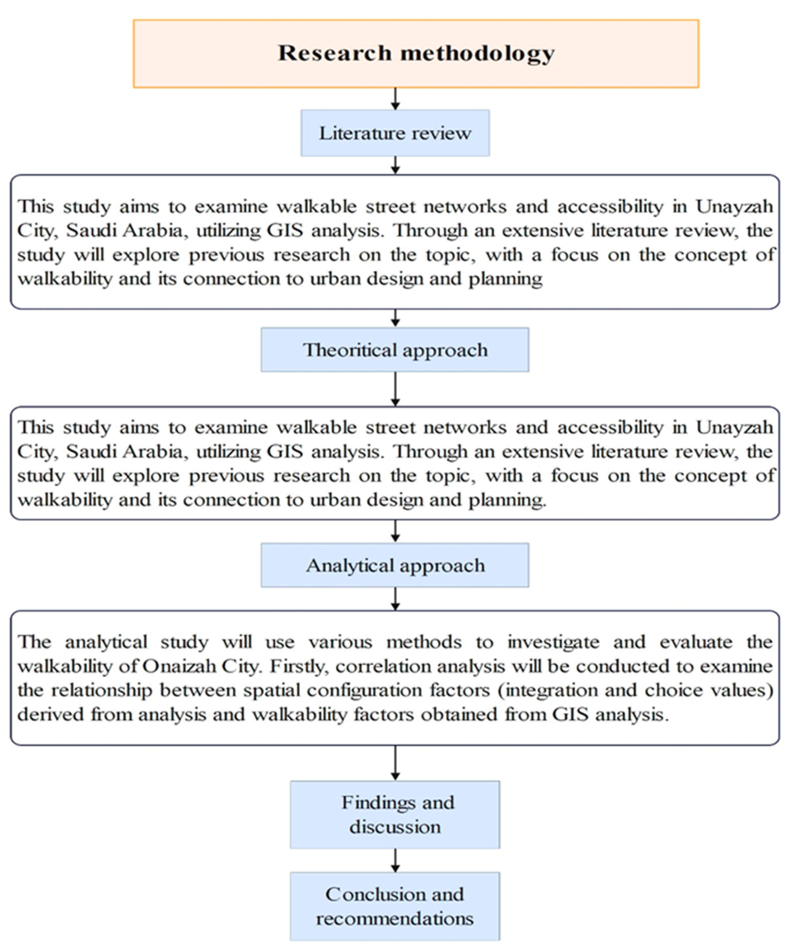
Figure 2.
Location maps of the city center in Onaizah. Source: The Authors.

Figure 3.
Data used for walkability analysis. Source: The Authors.
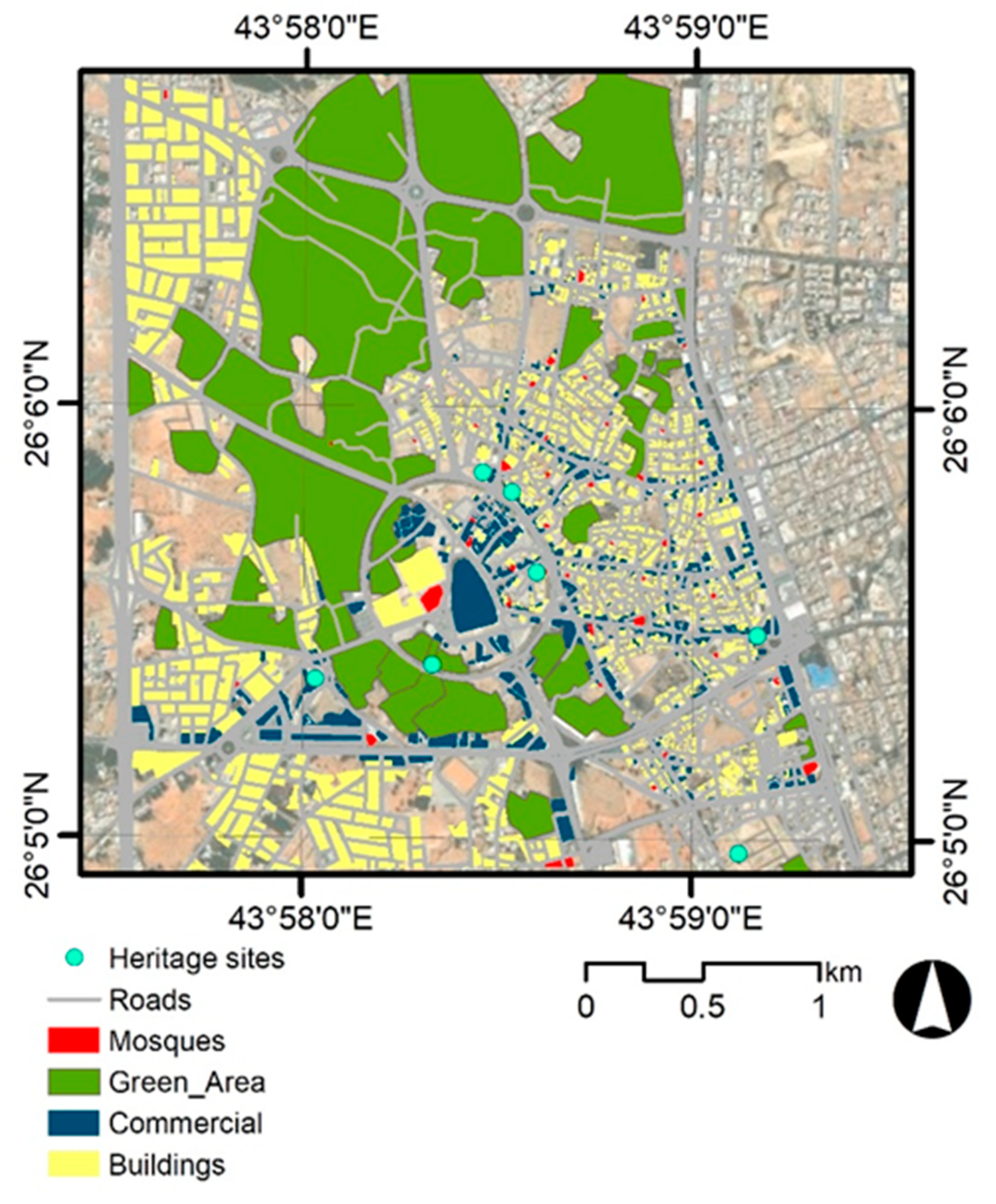
Figure 4.
Distance grids around walkability criteria. Source: The Authors.
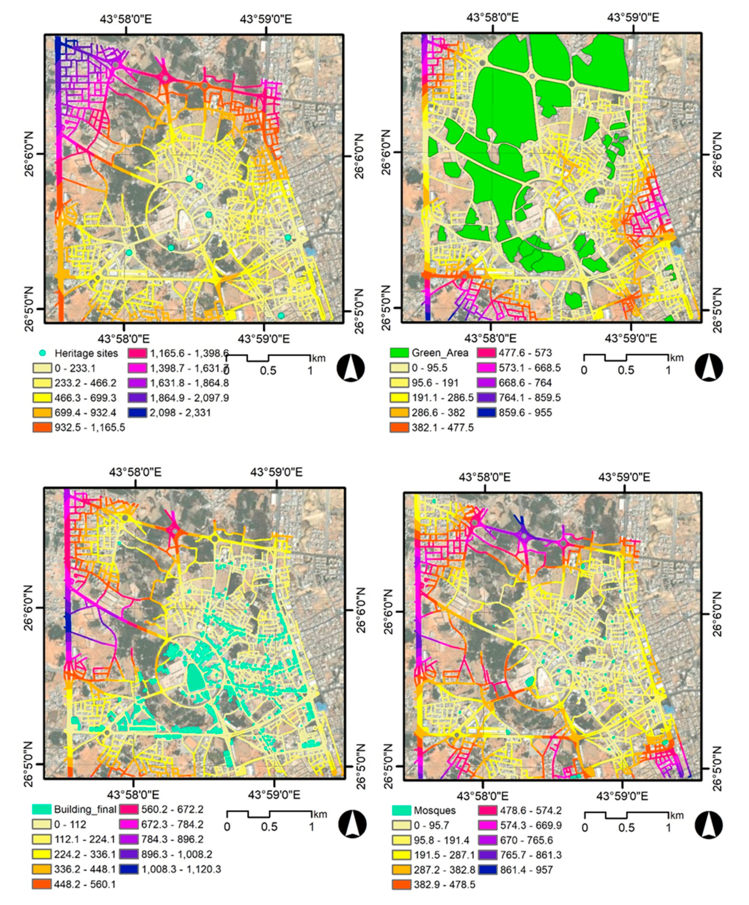
Figure 5.
Ranked distance grids around walkability criteria. Source: The Authors.
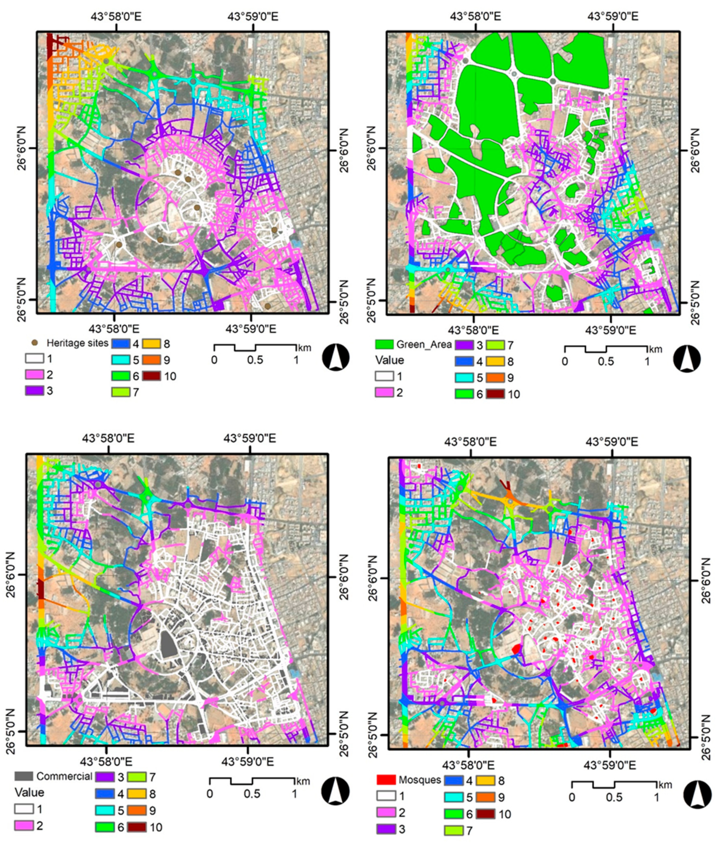
Figure 6.
Walkability index of the study area. Source: The Authors.
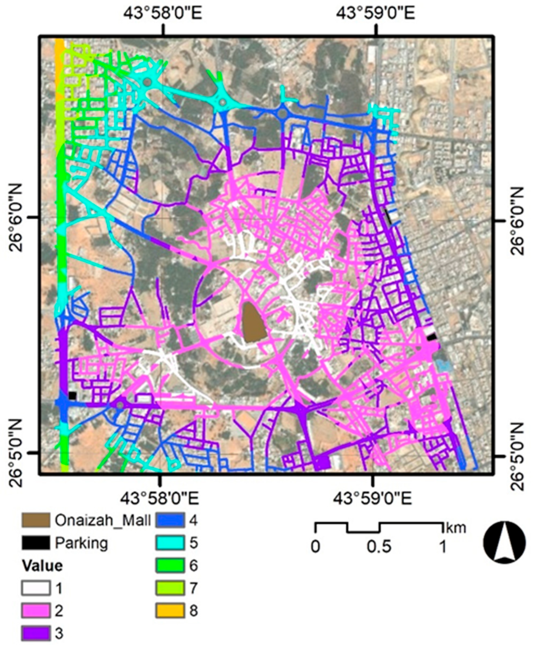
Figure 7.
walk paths of the study area. Source: The Authors.
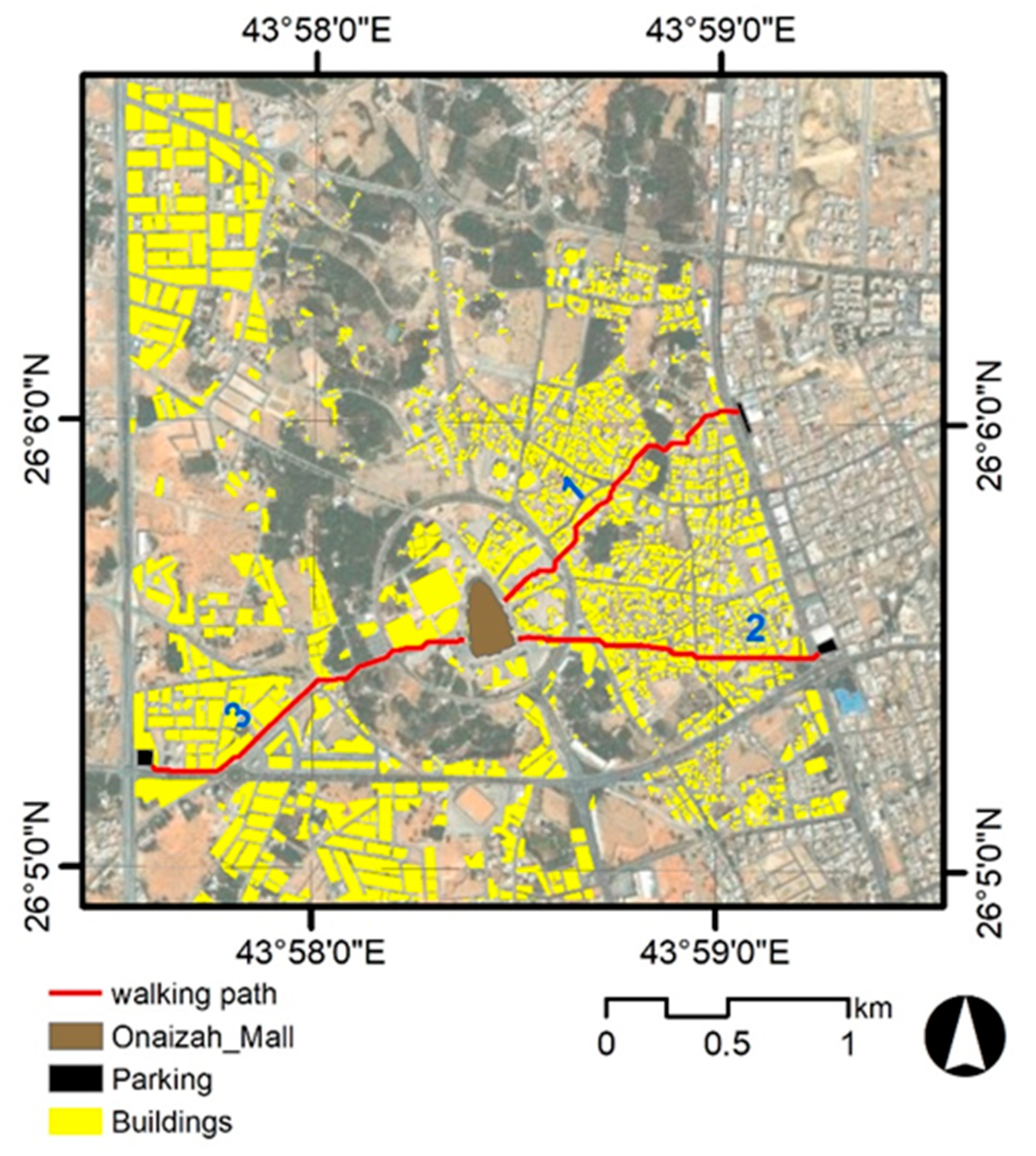

Table 1.
The resulting weights for the four study variables.
| Cat | Priority | Rank | |
|---|---|---|---|
| 1 | Heritage sites | 40.0% | 1 |
| 2 | Commercial sites | 15.0 % | 4 |
| 3 | Green area | 30.0% | 2 |
| 4 | Mosques | 15.0% | 3 |
Table 2.
Lengths of the three paths inferred from walkability analyses in the study area.
| Walking path | Length (m) |
|---|---|
| 1 | 1401 |
| 2 | 1283 |
| 3 | 1507 |
Disclaimer/Publisher’s Note: The statements, opinions and data contained in all publications are solely those of the individual author(s) and contributor(s) and not of MDPI and/or the editor(s). MDPI and/or the editor(s) disclaim responsibility for any injury to people or property resulting from any ideas, methods, instructions or products referred to in the content. |
© 2024 by the authors. Licensee MDPI, Basel, Switzerland. This article is an open access article distributed under the terms and conditions of the Creative Commons Attribution (CC BY) license (http://creativecommons.org/licenses/by/4.0/).
Copyright: This open access article is published under a Creative Commons CC BY 4.0 license, which permit the free download, distribution, and reuse, provided that the author and preprint are cited in any reuse.


