
Submitted:
23 January 2024
Posted:
24 January 2024
You are already at the latest version
Abstract
In Tropical Monsoon climates, precipitation exceeds evapotranspiration, leading to increased surface runoff, especially in floodplain regions. The Bhagirathi-Hooghly River in India is the focus of the study, which analyses hydrology, sediment yield, and water balance in this floodplain area. This investigation employs the Soil and Water Assessment Tool (SWAT) model within the ArcGIS environment, using remote sensing data. The study area is divided into 4 sub-basins and 40 Hydrological Response Units (HRUs), with a focus on Land Use/Land Cover (LULC) parameters, soil attributes, and slope characteristics. Calibration (1998-2010) and validation (2011-2018) of river discharge and sediment yield are performed using the SUFI-2 algorithm within SWAT-CUP. The calibration process shows a strong correlation between observed and simulated data points, indicating the model's accuracy. The study reveals a pattern of early-year evapotranspiration followed by increasing rainfall during the monsoon season, leading to heightened surface runoff and sediment yield. Excessive rainfall, therefore, emerges as a pivotal driver of flood incidences within the floodplain. The insights derived from the SWAT model's floodplain data have the potential to inform flood control and sedimentation mitigation strategies. The assimilation of this data can empower local stakeholders and contribute to sustainable livelihoods and improved living conditions, offering guidance for future governmental policies.
Keywords:
SWAT model
; sensitivity analysis
; SUFI-2 algorithm
; river discharge
; sediment yield
1. Introduction
Hydrological modelling examines the amount and characteristics of water flow in a particular river basin region or sub-catchment basin, its sustainable use, and the actual implementation of various scientific plans for watershed development. Hydrological or watershed modelling is useful for understanding the actual function of large transboundary river water flowing through a country, including any small basin and sub-basin regions. The use of GIS with hydro-meteorological information is very important for development of any type of hydrological model [1], which in turns help in watershed study. The flow in the meandering nature of floodplain region is greatly differ from other flow conditions of the river and possess a significant effect on the hydrological model and flood modelling [2,3].
Not only the hydro-meteorological parameters play a vital role in the development of hydrological models on a specific floodplain basin, but they also change land use factors [4]. The modification and planning of a specific river basin depend upon the changing pattern land use over time. When current and future water availability in a particular basin is represented using a hydrological model, it is also crucial to understand how hydrological model responses to altered land use [5]. As land use and climatic conditions change in a floodplain area, the water balance also shifts according how much sediment transport has been generated from the hydrological conditions. Sedimentation not only important in characterising the floodplain region, but also plays an essential role in determining the sustainable use of water resources, i.e. in a hydrological model. However, in order to be successful in long-term planning of hydrological model, the model must predict the results with sufficient accuracy [6,7]. In a country like India, the availability of un-polluted water is limited, especially with worsening climate change [8]. In that case the hydrological model of the floodplain region demands a distinctive feature, where sedimentation plays an important role, i.e. in influencing the water flow and the cyclical position of the water balance [9,10]. There is considerable need for hydrological or watershed models for getting sustainability in water resources in parts of the Gangetic plains and plateaus of Bihar, Uttar Pradesh, Jharkhand, Madhya Pradesh, West Bengal and Orissa in India.
Recognising the importance of efficient use of water resources in a particular river basin region, the hydrological model has advanced significantly over the last four decades [11,12]. Extensive uses of remote sensing and GIS have significantly supported the development the components needed to build a hydrological model. The experimental, conceptual, or process-based measurements can be implemented to build hydrological models through GIS, making it possible to build multiple disciplinary databases based on temporary and spatial changes [13]. Also, hydrological models can be developed by analysing long range data using GIS. These models include hydrological model like Areal Nonpoint Source Watershed Environment Response Simulation (ANSWERS) [14], Precipitation Runoff Modeling System (PRMS) [15], Agricultural Nonpoint Source model (AGNPS) [16], Water Erosion Prediction Project (WEPP) [17], CASCade of planes in 2-Dimensions (CASCAD) [18], Hydrological Simulation Program-Fortran (HSPF) [19], Soil and Water Assessment Tool (SWAT) [20], Large-Scale Catchment Model (LASCAM) [21], Dynamic Watershed Simulation Model (DWSM) [22], Agricultural Non-point Source Pollution model (AGNPS) [23]. Also, alteration in Land Use/Land Cover (LULC) have resulted in hydrological changes in a river basin, established through some models like HEC-HMS [24,25], Integrated Valuation of Ecosystem Services and Tradeoffs (InVEST) [26], Variable Infiltration Capacity (VIC) hydrological mode [27], and SWAT [28,29,30]. Of all these models, the applicability and use of the SWAT model established by USDA-ARS (United States Department of Agriculture-Agricultural Research Service) is considered practical.
The SWAT model, that can be flexibly applied to different river basins, which are a long-running, process-based, with real-time watershed [31]. River flow, discharge, sediment transport and water quality can be represented through SWAT model based on hydro-meteorological data. This model is usually calibrated and validated using a variety of statistical parameters. It also includes runoff simulation along a river basin, i.e. precipitation. When SWAT is used along a river basin in a floodplain area, it highlights the stable applicability of water resources through modified land use and planning implementation [32]. The SWAT model also emphasises the issue of sediment production through the modified LULC in floodplain areas [33]. Although the production of sediment transport is also highlighted by different models, i.e. by soil erosion determination, the use of SWAT model integration with Arc GIS allows the modelling of sediment yield along with river discharge in floodplain area.
The SWAT model generally based on a number of hydro-meteorological parameters and is sensitised by SWAT-Calibration and Uncertainty Programs (SWAT-CUP) to distinguish the most sensitive and non-essential parameters from this model performance [34,35,36]. This procedure is different for SWAT model compared to other existing hydrological models. This calibration and uncertainty of the SWAT model largely depends on Generalized Likelihood Uncertainty Estimation (GLUE), Parameter Solution (ParaSol), sequential uncertainty fitting (SUFI-2) algorithm, and a Bayesian framework implemented using Markov chain Monte Carlo (MCMC) and Importance Sampling (IS) techniques on calculation algorithms. Although the GLUE algorithm is the most widely used worldwide, the SUFI-2 algorithm is now increasingly used in large-scale hydrological models at various times due to its proven efficiency, where the previous version of SUFI-2 algorithm has been used to determine the hydrological model and its sensitivity over the river basin along the plateau region of central India [9]. The main purpose of using SWAT model in floodplain area is to model the amount of sediment production based on different surface runoff conditions.
As a key part of Ganges, Bhagirathi-Hooghly River separates from the main river near the Mithipur located at Murshidabad District. It flows into the Bengal Bay and encircling Kolkata [37]. That river is crucial for a wide range of social functions including of industrial activities, irrigation, and human habitation. Existing studies on Bhagirathi-Hooghly River have also emphasised spatial variations on the meandering condition through different models, i.e. migration coefficient approach, and proposed channel instability and meandering consequences [32,33,34]. Due to the floodplain and low land areas, the amount of flood along the Bhagirathi-Hooghly basin has become more severe. Also, the amount of sedimentation has increased due to the decrease in the velocity of the river flow, and hence there has been a rise of sand bar along the river bed. Additionally, the demand for water is much higher in this region due to the large presence of agriculture and industry on both sides of the river. In short, gradual changes in land use possess a threat on the sustainability of water and sediment production throughout the region.
A hypothetical look at the previous works done on the SWAT model shows some hydrological simulations by using SWAT model in the Nabadwip-Kalyani stretch of the Bhagirathi-Hooghly River [10]. The calibration (1998-2010) and validation (2011-2018), process reveals the river discharge and sediment yield for the entire stretch in this study, based on hydro-meteorological data. The SWAT model has been shown to be calibrated and validated based on adequate results, mainly through SWAT-CUP and SUFI-2 algorithms. The primary objective of the article is to assess the effectiveness of the SWAT model in estimating river discharge and sediment yield using hydro-meteorological data in the floodplain region. Furthermore, it aims to identify the significance of hydrological parameters by sensitivity and uncertainty analyses. This study also attempts to outline the water balance along the nature of the floodplain region of the entire sub-catchment basin. In the future, data from the SWAT model can use to configure governmental decision and policy, as well as improve the river discharge and sedimentation conditions along the floodplain zone.
2. Materials and Methods
2.1. Study Area:
The selected sub-catchment basin falls into the middle part of Bhagirathi-Hooghly River stretch about 161 km long from Nabadwip (upstream) to Kalyani (downstream), This stretch passes through various blocks within the districts of Burdwan, Nadia, and Hooghly in West Bengal, India. The representation coordinates of the basin situate from 23˚24′45″ N - 88˚22′45″ E to 22˚58′01″ N - 88˚24′27″ E. The studied area is the Rarh region located at the lower part of Bengal Basin [38,39]. The area was surrounding by sand and sandy clay along the river course. More specifically, fine silt, sandy loam, and muddy soil have been observed there (Figure 1). Since colonised era, the area has been encountering severe floods. Heavy rainfall during monsoon tropical cyclones, land incursion by urban rivers, uncontrolled sedimentation, unmanaged levee and building construction in the riverbank area are some key problems. Bhagirathi Hooghly River is also associated with various tributaries. Notably, the Khari River joins from the right side, while the Jalangi and Churni rivers merge from the left side. Its combined area accounts for approximately 1690 km2.
The hydrodynamic condition of the studied area differs significantly from other Indian regions due to floodplain morphology. Riverbank erosion increases due to movement of lateral bank line as a meandering reaction. Wetlands, billabong and shoal forming also attribute to the key features of floodplain. The investigated region, which characterised by tropical monsoon climate, gets between 110 - 124 wet days annually, with averaged rainfall between 1500 - 1800 mm. The averaged annual precipitation from 1998 to 2018 illustrates that the rainfall has an elevated trend (Figure 2a). As the rationale, tropical cyclones and depressions have caused harsher weather over the duration of past few decades. These climatic disturbances bring heavy rainfall during the rainy season, with precipitation levels ranging from 150 to 250 mm per day. Consequently, river water levels surge rapidly, leading to a decline in navigability. The Nabadwip-Kalyani sub-basin consists of several blocks and about 662 mouzas in East Burdwan, Hooghly and Nadia districts. Some of these mouzas are prone to river erosion, and some areas are prone to floods. Due to embankment along the banks in those areas, they are higher than the natural plain. But in the low-lying areas next to the embankment opposite the river, the water accumulates during the monsoon.
Since the outlet of the Nabadwip-Kalyani sub-basin is compressed like a funnel enclosing the urban area at the bottom, the runoff causes problems to the discharge of sediments. The trending nature of peak discharge with the sedimentation of the river (1998-2018) shows that the amplified concentration of sediment from the upstream region with peak discharge indicates massive sedimentation in the area (Figure 2b). The Bhagirathi-Hooghly River is slowly moving towards becoming a rain-fed river in future. At the same time, if one compares the amount of rainfall with the duration of floods in the region through discharge, one can see that the year there is more rainfall, the amount of flooding and discharge increase (Figure 2c). The Bhagirathi-Hooghly River is gradually diminishes over time. The uncontrolled construction of houses along the riverbanks, and constant urban encroachment have resulted in changes of land use. The construction of jetties and rampant sand mining from the riverbed increases the possibility of flood in this region.
2.2. Data Used
Since the SWAT model is built around the environment of Arc GIS, it is necessary to first determine the utilised software (https://swat.tamu.edu/software/arcswat) and assimilate it into Arc GIS. ASTER (Advanced Spaceborne Thermal Emission and Reflection Radiometer) DEM (Digital Elevation Model) has been employed to determine the information such as altitude, land slope, river flow propagation, and several different hydrological parameters (https://earthexplorer.usgs.gov/) (Figure 3a,b). In addition, the pre-monsoon LULC map (on 18th February 2018) obtained from USGS Landsat 8 OLI (Operational Land Imager) geo-rectified mapping (Path and Row-138/44 with resolution 30 m) has been utilised to identify varying geographical and communicational parameters, as classified into 6 classes in Figure 3d. These base map images are forecasted by Universal Transverse Mercator projection, i.e. at UTM 45N, and 1984’s World Geodetic Survey (WGS) in Arc-GIS software under v10.4.1. For the images, the geometric correction was used with Root Mean Square Error (RMSE) of ±0.5 pixels to adjust the image. For the soil map, soil condition and their potential propagation have been acquired from the United Nation’s Food and Agricultural Organisation classifications (http://www.fao.org/geonetwork/srv/en/metadata.show?id=14116) (Figure 3c). Daily grid-based weather data for the entire sub-catchment basin (1998-2018), such as temperature, precipitation, wind speed, solar radiation, and relative humidity, were obtained from SWAT's global weather data file (https://globalweather.tamu.edu/). In some cases, rainfall information has been downloaded from NASA's meteorological files (https://power.larc.nasa.gov/cgi-bin/agro.cgi). However, the SWAT model itself contains weather (https://swat.tamu.edu/media/99082/cfsr_world.zip) and soil (http://downloads.indiaremotesensing.com/SWAT2012.zip) information, which it combines with data from several sources. Since our whole research is based on Indian territory, the SWAT model collects information about India such as weather, soil, others from the SWAT website (https://swat.tamu.edu/software/links/india-dataset/). Report on discharge, sedimentation, other parameters of Bhagirathi-Hooghly river has been derived from information by the Irrigation Department, Government of West Bengal and Kolkata Port Trust.
2.3. Methodology
SWAT model setup
DEM was first developed according to the hydrological SWAT model setup of the entire sub-catchment area [40]. The DEM then identified step-by-step flow direction, accumulation, river network and, above all, the outlet area of the entire sub-catchment. LULC, soil and slope were then projected on a specific boundary basis through HRU development [41]. The whole model of this study was operated based on hydro-meteorological data (Figure 4). The SWAT hydrological method is based on water balance equation.
Where, is the total water content (mm), implies water content in first soil in i-th day (mm), denoted the rainfall in i-th day (mm), is the surface runoff in i-th day (mm), is the evapotranspiration in i-th day i (mm), is the vadose zone’s percolated water from surface soil profile in i-th day i (mm), is the return flow in i-th day (mm).
Uncertainty analysis
For calibration, validation, uncertainty and sensitivity analyses, a generic interface program called SWAT-CUP has been used [42]. The SUFI-2 algorithm is useful for determining the uncertainty between the variables, parameters and measured site data [43]. Also, the sensitivity is measured using SUFI-2 by determining the effective and overfitted parameters used by the model. Uncertainty is determined based on a 95% prediction, with a upper limit of 97.5% and lower limit of 2.5%. In addition, the r- and p-factors are capable to determine the model's calibration efficiency and uncertainty. If the value of p-factor is 1, it indicates a high level of uncertainty with low quality output. The quality factor of the calibration is revealed through the r-factor, which closer to 0 means a better matching to measurement. It is important to maintain a balance between both the factors, otherwise the output of the model may be completely disrupted. When an balanced and acceptable value is obtained for both factors, the level of uncertainty of the parameters can be minimised.
Model performance analysis
The evaluation of the SWAT model in the Nabadwip-Kalyani sub-catchment basin has been assessed using three statistical parameters: Coefficient of Determination (R2), Nash – Sutcliff efficiency (NSE), and Percent bias (PBIAS) [44,45]. The value of R2 is always between 0 and 1. Result shows the model performance is good when the value of R2 is close to 1, although it is reasonably acceptable when the value of R2 is greater than 0.5. Observed and simulated data can be calibrated by NSE within the ratio of 1: 1. NSE values can range from negative infinity to 1, where 1 is the best value. PBIAS measures the average tendency of simulated values, which are either smaller or larger than the observed values. If the PBIAS value is positive, then the data is underestimated and if PBIAS is negative then it is overestimated.
where, and are the observed variable, are the simulated variable, .
3. Results and Discussion
SWAT model sensitivity analysis
The SWAT sensitivity analysis can reveal the information of suitable and unsuitable parameters for model formation. It significantly reduces model calibration time by identifying the precise parameters and helps to fine-tune the model based on accurate results. The utilised model has been analysed and calibrated using a total of 22 parameters, which have been ranked according to their sensitivity, based on the river discharge and sediment yield (Table 1). Out of the 22 parameters, curve number, effective hydraulic conductivity and surface runoff lag coefficient are identified as the most important adjustments for both river discharge and sediment concentration. Groundwater revap coefficient, base flow alpha factor, available water capacity of soil layer and depth from soil surface to bottom layer are the most effective factors for calibrating river discharge (Figure 5a). However, the linear coefficient is utilised to compute the amount of sediment that is re-entrained in the sediment routing process within the channel. Main channel’s effective hydraulic conductivity, Manning’s ‘n’ for main channel and slope are the key factors in deciding sediment concentration (Figure 5b). Sensitivity ranking has a number of parameters that have profound effect on the whole model, and they are calibrated in the last step according to that ranking.
Calibration and validation of river discharge and sediment yield through SWAT model
After obtaining all the data for the SWAT model, it has been calibrated and validated using SUFI-2 algorithm with SWAT-CUP. Calibration was based on data from 1998 to 2010, while validation depended on data from 2011 to 2018. All data from 1998 and 1999 are taken as warm up period. Basically, all the data is sorted on the basis of monthly average. After conducting the calibration and validation of the model, several statistical parameters were employed to enhance the assessment of its performance, while ensuring the appropriate organisation of the model's data. A comparison between the monthly observed and simulated data on river discharges shows that rainfall and river discharges were significantly higher during the calibration period in 2002, 2005, 2006, 2007 and 2009, which in turn triggered flooding along the entire floodplain sub-catchment basin (Figure 6a). During the validity period, rainfall and discharge were high from 2013 to 2017, which often caused floods (Figure 6b).
The discharge has been escalated with the rainfall increase during the monsoon. Based on this hypothesis, it can be postulated that the runoff increases when the rainfall is more along the investigated sub-catchment basin. As a result, the soil holding capacity of this region is low. Almost the same results are seen in the case of sediment concentration or yield. During the calibration and validation periods, the sediment concentration exhibits a positive correlation with the monthly river discharge, where floods also cause large amounts of sediment to enter the river from land. The amount of sediment concentration is higher from 2002, 2005-2009, 2012-2015 (Figure 7 a and b). This sediment concentration is thought to be higher due to the normal characteristics of the floodplain region. Nevertheless, the surge in river discharge and sediment yield caused by excessive rainfall during the monsoon season initiates inundation within the studied area.
Uncertainty analysis
After employing the SUFI-2 algorithm to calibrate the model, it has been observed that the modelling data’s uncertainty ranges from 91.5 to 97.5 percent. But as seen in both river discharge (Figure 8) and sediment concentration (Figure 9), 95% of simulated data have uncertainty. As a result, it is known that the required output from the model is not positioned correctly and optimally.
Model performance analysis
Figure 10, which compares the observed and simulated data throughout the calibration and validation periods, yields positive outcomes for river discharge (R2 of 0.80 and 0.86, respectively). Similarly, comparisons between observed and simulated values for sediment concentration show good corresponding results (R2 of 0.84 and 0.89, respectively) (Figure 10). After performing statistical performance analysis separately on the calibration and validation periods of monthly observed and simulated data, well-corresponding outcomes are observed, based on R2, NSE and PBIAS considerations. In case of monthly calibration, the values of R2, NSE and PBIAS on river discharge are 0.80, 0.83 and -8.95 respectively, while in case of validation, the values are 0.86, 0.88 and -9.21 respectively. Finally, the values for calibration of sediment yield are 0.84, 0.87 and -6.51 respectively, and for validation, the values are 0.89, 0.91 and -13.2 respectively.
Water balance of sub-catchment basin
Since the entire sub-catchment area is divided into 4 sub-basins, it is easy to ascend the water balance information along the sub-basin after operating the SWAT model. Given that the entire area falls under the purview of the tropical monsoon climate, rainfall is expected to be intense while evapotranspiration levels are high from March to September. Again, the amount of surface runoff is higher when the pore spaces are closed, even if the ground water is recharged according to the character of the soil. The hydro-meteorological parameters employed in the HRU analysis were utilised to ascertain the water balance quantity across the entire region.
The water balance of the entire sub-catchment basin shows that the main controlling factors are precipitation and evapotranspiration. According to each sub-basin, the amount of evapotranspiration at the beginning of the year increased by 54% compared to rainfall. Rainfall during monsoons was 71% higher in evapotranspiration, which in turn leads to flooding (Table 2). Excessive rainfall reduces the ability of water to enter the soil and increases the amount of surface runoff. Dividing the water balance by each sub-basin shows that sub-basin 4 has the highest amount of surface runoff. If the water balance profile of the entire sub-catchment basin is divided into different months of the year, a much different picture can be obtained. Although evapotranspiration and precipitation are the main controlling factors for water balance in this basin, their influence varies from month to month (Table 3 and Figure 11). Lack of precipitation at the early phase of the year increases the amount of evapotranspiration. Result shows that the amount of moisture in the soil decreased while the dehydration was observed. In monsoon, the amount of rainfall increased from June to September to exceed the evapotranspiration. Consequently, there was a rise in surface runoff, leading to erosion of the soil surface and its accumulation in the river where the amount of sedimentation increased. The result from water balance ratio along the entire sub-catchment basin caused the surface runoff, i.e. rainfall was 62%, evapotranspiration was 35% and ground water recharge was 3%.
Sediment from the entire region mainly originated from land, and entered into the river through the surface runoff, to increase the amount of river sediment concentration (i.e. mainly during the monsoon). Analysis of water balance according to HRU shows that out of the total 40 HRUs, 24 cover agricultural land and 10 cover urban area. These urban areas were acquiring 34% and 47% of total evapotranspiration and surface runoff rainfall. Its proportion from agricultural areas is 27% and 33%, respectively. HRU 22 has the highest amount of sediment concentration due to its loess soil content.
4. Conclusions and Recommendation
The study examined the effectiveness of the SWAT model within the sub-catchment basin of Lower Gangetic floodplain region, where it focused on the river discharge and sediment yield investigations. The SWAT model provided a depiction of the water balance within the floodplain area under the tropical monsoon climate. The model was calibrated for the period 1998-2010 and validated for the period 2011-2018 using the SUFI-2 algorithm provided by SWAT-CUP. Sensitivity analysis showed that curve number, effective hydraulic conductivity and surface runoff lag coefficient that were imperative for both river discharge and sediment concentration. The findings derived from the SWAT model indicated that both evapotranspiration and precipitation play crucial roles in the water balance. However, it is noteworthy that precipitation accounts for 62% of the overall water balance. Despite the evapotranspiration level, the excessive rainfall in tropical monsoon climates has caused a rise in surface runoff. This could potentially result in future flooding. The results of the SWAT model also suggested that an average of about 41.3 t / ha / year sediment has been produced each year, which was deposited into the river. Calibration and validation prove that the SWAT model can accurately describe the hydrological and sedimentological situation of the floodplain region.
From the result of SWAT model, the location of hydrological and sediment deposition according to the floodplain topography of Nabadwip-Kalyani sub-catchment stretch can be known. During calibration and validation, the amount of river discharge increased with precipitation, which caused flooding. The subsequent prediction of the SWAT model can provide indication to the duration of flooding, which can help to determine government policy and sustain local stakeholders’ interest. The sediment concentration calculation from the SWAT model can be used to inform the sediment control method by policy makers. Above all, based on the information obtained from the SWAT model, it is possible to create flood control management and agro-based environment in the region.
Author Contributions
Writing—review and editing, conceptualization, investigation, methodology, resources, J.H.P.; Writing— original draft preparation, conceptualization, data curation, methodology, software, S.M.; Writing— original draft preparation, conceptualization, data curation, methodology, software, M.K. All authors have read and agreed to the published version of the manuscript.
Data Availability Statement
The data will be made available on reasonable request to the corresponding author.
Conflicts of Interest
The authors declare no conflict of interest.
References
- Farzana, S.Z.; Zafor, M.A.; Al Shahariar, J. Application of SWAT Model for Assessing Water Availability in Surma River Basin. Journal of the Civil Engineering Forum 2019, 5, 29–38. [Google Scholar] [CrossRef]
- Pu J. H., Pandey M., Li J., Satyanaga A, Kundu S., Hanmaiahgari P. R., and Shao S., (eds.) “The Urban Fluvial and Hydro-Environment System,”, 2023, Frontiers Media SA. Lausanne.
- Pu J. H., (ed.) “Environmental Hydraulics, Turbulence and Sediment Transport,” MDPI Publisher, 2022, ISBN 978-3-0365-3242-4 (Hbk); ISBN 978-3-0365-3243-1 (PDF).
- Marhaento, H.; Booij, M.J.; Rientjes, T.H.; Hoekstra, A.Y. Attribution of changes in the water balance of a tropical catchment to land use change using the SWAT model. Hydrological processes 2017, 31, 2029–2040. [Google Scholar] [CrossRef]
- Bal, M.; Dandpat, A.K.; Naik, B. Hydrological modeling with respect to impact of land-use and land-cover change on the runoff dynamics in Budhabalanga river basing using ArcGIS and SWAT model. Remote Sensing Applications: Society and Environment 2021, 23, 100527. [Google Scholar] [CrossRef]
- Pu, J.H.; Shao, S.; Huang, Y.; Hussain, K. Evaluations of SWEs and SPH Numerical Modelling Tech-niques for Dam Break Flows. Engineering Applications of Computational Fluid Mechanics 2013, 7, 544–563. [Google Scholar] [CrossRef]
- Pu, J.H.; Huang, Y.; Shao, S.; Hussain, K. Three-Gorges Dam Fine Sediment Pollutant Transport: Turbulence SPH Model Simulation of Multi-Fluid Flows. Journal of Applied Fluid Mechanics 2016, 9, 1–10. [Google Scholar] [CrossRef]
- Mestry, A.; Narwade, R.; Nagarajan, K. Estimation of water balance components of watersheds in the Manjira River Basin using SWAT model and GIS. Int J Eng Adv Technol. 2020, 9, 3898–3907. [Google Scholar] [CrossRef]
- Hanmaiahgari, P.R.; Gompa, N.R.; Pal, D.; Pu, J.H. Numerical Modeling of the Sakuma Dam Reservoir Sedimentation. Natural Hazards 2018, 91, 1075–1096. [Google Scholar] [CrossRef]
- Ghosh, A.; Roy, M.B.; Roy, P.K.; Mukherjee, S. Assessing the nature of sediment transport with bridge scour by 1D sediment transport model in the sub-catchment basin of Bhagirathi–Hooghly river. Modeling Earth Systems and Environment 2021, 7, 2823–2845. [Google Scholar] [CrossRef]
- Pu, J.H. Turbulent rectangular compound open channel flow study using multi-zonal approach. Environmental Fluid Mechanics 2019, 19, 785–800. [Google Scholar] [CrossRef]
- Pu, J.H.; Pandey, M.; Hanmaiahgari, P.R. Analytical modelling of sidewall turbulence effect on streamwise velocity profile using 2D approach: A comparison of rectangular and trapezoidal open channel flows. Journal of Hydro-environment Research 2020, 32, 17–25. [Google Scholar] [CrossRef]
- Pu, J.H. Conceptual Hydrodynamic-Thermal Mapping Modelling for Coral Reefs at South Singapore Sea. Applied Ocean Research 2016, 55, 59–65. [Google Scholar] [CrossRef]
- Beasley, D.B.; Huggins, L.F.; Monke, E.J. ANSWERS: a model for watershed planning. Transactions, American Society of Agricultural Engineers 1980, 23, 938–944. [Google Scholar] [CrossRef]
- Leavesley, G.H.; Markstrom, S.L.; Restrepo, P.J.; Viger, R.J. A modular approach to addressing model design, scale, and parameter estimation issues in distributed hydrological modelling. Hydrol Process 2002, 16, 173–187. [Google Scholar] [CrossRef]
- Young, R.A.; Onstad, C.A.; Bosch, D.D.; Anderson, W.P. AGNPS: A nonpoint-source pollution model for evaluating agricultural watersheds. J Soil Water Conservation 1989, 44, 168–173. [Google Scholar]
- Laflen, J.M.; Lane, L.J.; Foster, G.R. A new generation of erosion prediction technology. 1991. [Online]. Available: www.swcs.org.
- Julien, P.Y.; Saghafian, B.; Ogden, F.L. Water Resources Bulletin Raster-Based Hydrologic Modeling Of Spatially-Varied Surface Runoff. Journal of the American Water Resources Association 1995. [CrossRef]
- Donigian, A.S., Jr.; Bicknell, B.R.; Imhoff, J.C. Hydrological Simulation Program-Fortran (HSPF). Computer models of watershed hydrology 1995, 395–442. [Google Scholar]
- Srinivasan, R.; Arnold, J.G.; Jones, C.A. Hydrologic modelling of the United States with the soil and water assessment tool. Int J Water Resour Dev 1998, 14, 315–325. [Google Scholar] [CrossRef]
- Sivapalan, M.; Viney, N.R.; Zammit, C. LASCAM: large scale catchment model. Mathematical models of large watershed hydrology 2002, 579–648. [Google Scholar]
- Borah, D.K.; Bera, M.; Shaw, S.; Keefer, L. Dynamic Modeling and Monitoring of Water, Sediment, Nutrients, and Pesticides in Agricultural Watersheds during Storm Events. 1999.
- Young, R.A.; Onstad, C.A.; Bosch, D.D.; Anderson, W.P. AGNPS: A nonpoint-source pollution model for evaluating agricultural watersheds. J Soil Water Conserv 1989, 44, 168–173. [Google Scholar]
- Younis, S.M.Z.; Majid, M.; Ammar, A. Satellite-based rainfall estimation and discharge measurement of Middle Indus River, Pakistan. Arabian Journal of Geosciences 2017, 10. [Google Scholar] [CrossRef]
- Koneti, S.; Sunkara, S.L.; Roy, P.S. Hydrological modeling with respect to impact of land-use and land-cover change on the runoff dynamics in Godavari River basin using the HEC-HMS model. ISPRS Int J Geoinf 2018, 7. [Google Scholar] [CrossRef]
- Geng, X.; Wang, X.; Yan, H.; Zhang, Q.; Jin, G. Land use/land cover change induced impacts on water supply service in the upper reach of Heihe River Basin. Sustainability (Switzerland) 2015, 7, 366–383. [Google Scholar] [CrossRef]
- Garg, V.; Nikam, B.R.; Thakur, P.K.; Aggarwal, S.P.; Gupta, P.K.; Srivastav, S.K. Human-induced land use land cover change and its impact on hydrology. HydroResearch 2019, 1, 48–56. [Google Scholar] [CrossRef]
- Biru, Z.; Kumar, D. Calibration and validation of SWAT model using stream flow and sediment load for Mojo watershed, Ethiopia. Sustain Water Resour Manag 2018, 4, 937–949. [Google Scholar] [CrossRef]
- Li, Y.; et al. Spatiotemporal impacts of land use land cover changes on hydrology from the mechanism perspective using SWAT model with time-varying parameters. Hydrology Research 2019, 50, 244–261. [Google Scholar] [CrossRef]
- Munoth, P.; Goyal, R. Impacts of land use land cover change on runoff and sediment yield of Upper Tapi River Sub-Basin, India. International Journal of River Basin Management 2020, 18, 177–189. [Google Scholar] [CrossRef]
- Júnior, R.F.; Montenegro, A. Impact of land use change on the water balance in a representative watershed in the semiarid of the state of Pernambuco using the swat model the main springs and streams are generally intermittent, and both native vegetation and the watershed. The Aim. 2019, 4430, 110–117. [Google Scholar]
- Manaswi, C.M.; Thawait, A.K. Application of soil and water assessment tool for runoff modeling of Karam River basin in Madhya Pradesh. International Journal of Scientific Engineering and Technology 2014, 3, 529–532. [Google Scholar]
- Pandi, D.; Kothandaraman, S.; Kuppusamy, M. Simulation of water balance components using SWAT model at sub catchment level. Sustainability 2023, 15, 1438. [Google Scholar] [CrossRef]
- Eckhardt, K.; Arnold, J. Automatic calibration of a distributed catchment model. J. Hydrol. 2001, 251, 103–109. [Google Scholar] [CrossRef]
- White, K.; Chaubey, I. Sensitivity analysis, calibration, and validations for a multisite and multivariable SWAT model. J. Am. Water Resour. Assoc. 2005, 41, 1077–1089. [Google Scholar] [CrossRef]
- Lu, Z.; Zou, S.; Xiao, H.; Zheng, C.; Yin, Z.; Wang, W. Comprehensive hydrologic calibration of SWAT and water balance analysis in mountainous watersheds in northwest China. Physics and Chemistry of the Earth, Parts A/B/C 2015, 79, 76–85. [Google Scholar] [CrossRef]
- Roy, M.B.; Ghosh, A.; Kumar, A.; Roy, P.K. Study of water productivity model on wetlands: a case study of Bhagirathi-Hooghly sub-catchment basin, Southern West Bengal, India. Environ Monit Assess 2021, 193, 1–23. [Google Scholar] [CrossRef] [PubMed]
- Ghosh, A.; Roy, M.B.; Roy, P.K. Estimation and prediction of the oscillation pattern of meandering geometry in a sub-catchment basin of Bhagirathi-Hooghly River, West Bengal, India. SN Appl Sci 2020, 2. [Google Scholar] [CrossRef]
- Ghosh, A.; Roy, M.B.; Roy, P.K. Evaluating the performance of MIKE NAM model on rainfall–runoff in lower Gangetic floodplain, West Bengal, India. Model Earth Syst Environ 2022, 8, 4001–4017. [Google Scholar] [CrossRef]
- Chiphang, N.; Bandyopadhyay, A.; Bhadra, A. Assessing the effects of snowmelt dynamics on streamflow and water balance components in an Eastern Himalayan river basin using SWAT model. Environmental Modeling & Assessment 2020, 25, 861–883. [Google Scholar]
- Ahn, S.R.; Kim, S.J. Analysis of water balance by surface–groundwater interaction using the SWAT model for the Han River basin, South Korea. Paddy and Water Environment 2018, 16, 543–560. [Google Scholar] [CrossRef]
- Abbaspour KC (2015) SWAT-CUP: SWAT Calibration and Uncertainty Programs – A User Manual, Department of Systems Analysis, Integrated Assessment and Modelling (SIAM), Eawag. Swiss Federal Institute of Aquatic Science and Technology, Duebendorf.
- Nasiri, S.; Ansari, H.; Ziaei, A.N. Simulation of water balance equation components using SWAT model in Samalqan Watershed (Iran). Arabian Journal of Geosciences 2020, 13, 1–5. [Google Scholar] [CrossRef]
- Moriasi, D.N.; Arnold, J.G.; Van Liew, M.W.; Bingner, R.L.; Harmel, R.D.; Veith, T.L. Model evaluation guidelines for systematic quantification of accuracy in watershed simulations. Trans ASABE 2007, 50, 885–900. [Google Scholar] [CrossRef]
- Zare, M.; Azam, S.; Sauchyn, D. Evaluation of Soil Water Content Using SWAT for Southern Saskatchewan, Canada. Water 2022, 14, 249. [Google Scholar] [CrossRef]
Figure 1.
Studied area maps of watershed and basin position.
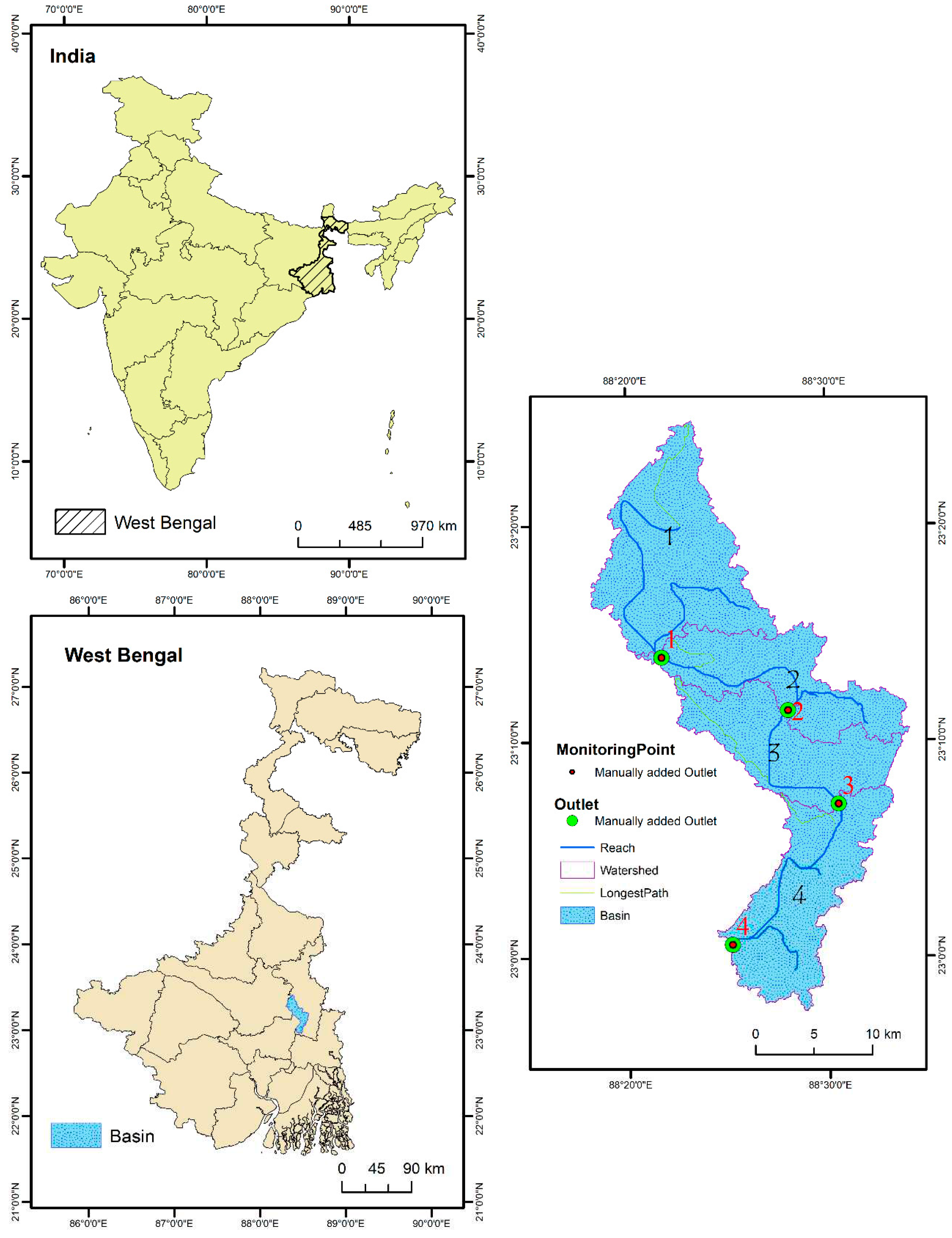
Figure 2.
Hydro-meteorological condition of investigated area: a) annual rainfall (1998-2018), b) Relation between discharge and sedimentation, c) Relation between annual rainfall and peak discharge.
Figure 2.
Hydro-meteorological condition of investigated area: a) annual rainfall (1998-2018), b) Relation between discharge and sedimentation, c) Relation between annual rainfall and peak discharge.
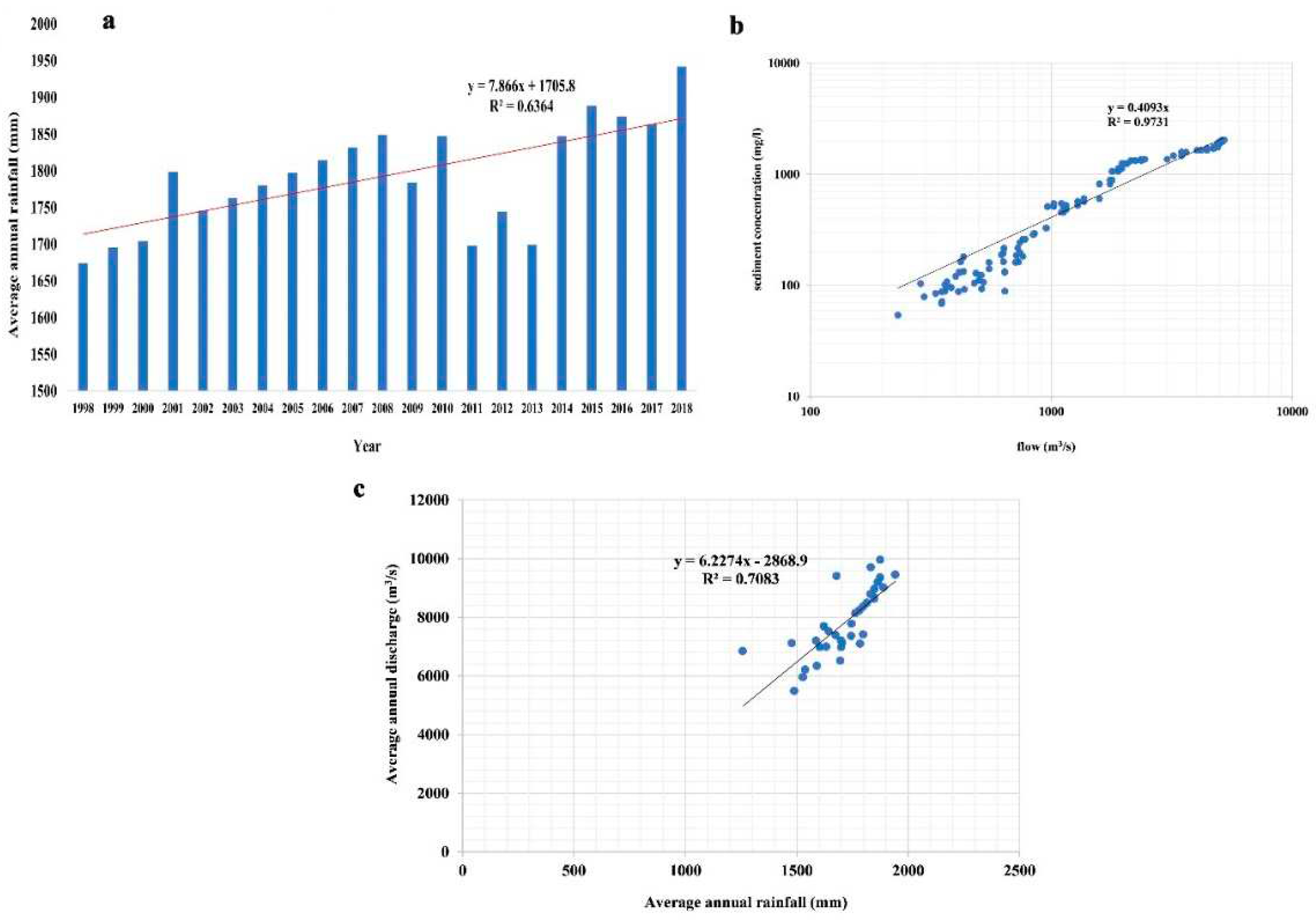
Figure 3.
Parameter used to develop SWAT calibration a) DEM, b) Slope, c) Soil and d) LULC.
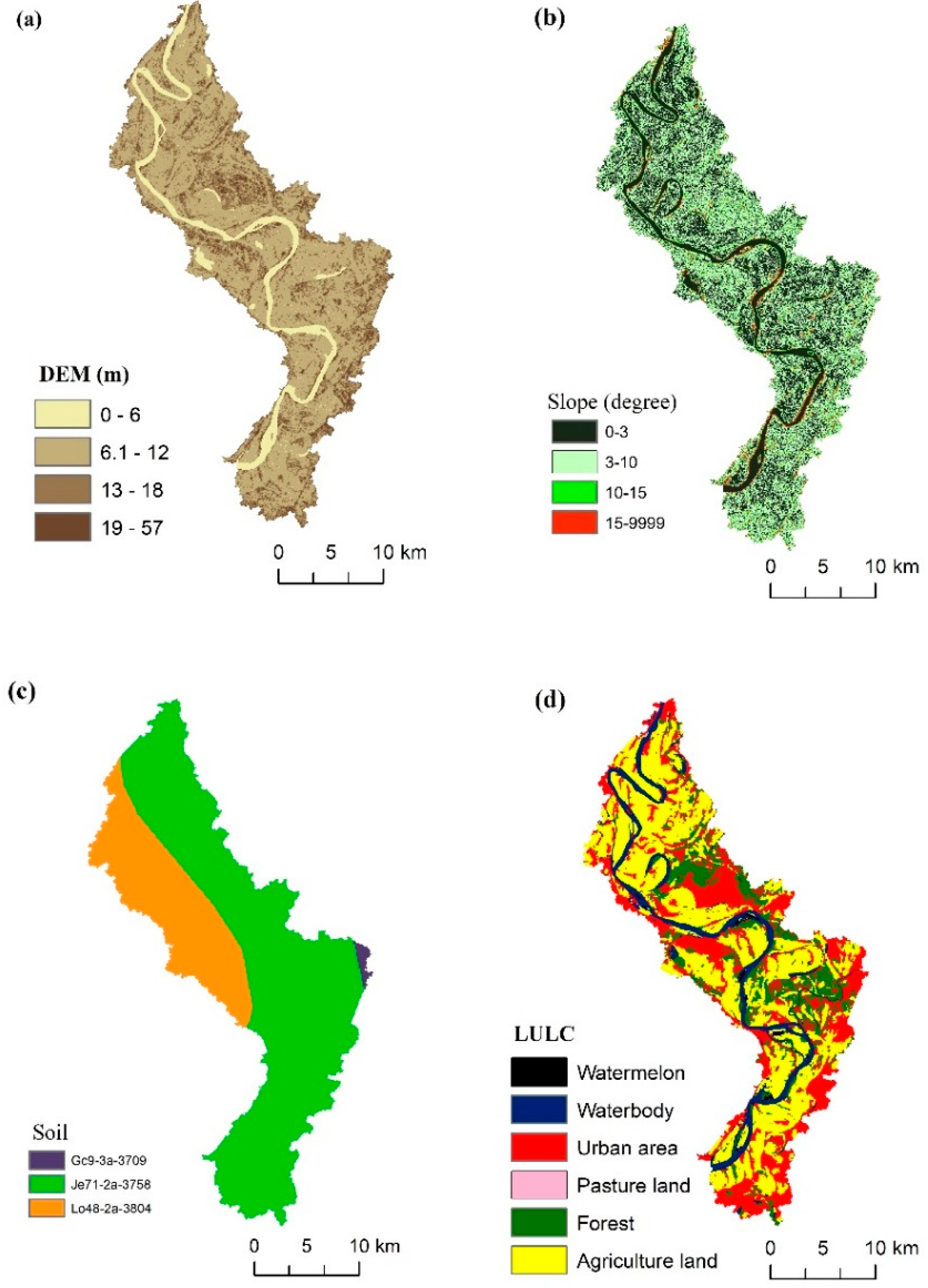
Figure 5.
Parameters affecting river discharge and sediment concentration through SWAT model (a) p-value; (b) t-stat.
Figure 5.
Parameters affecting river discharge and sediment concentration through SWAT model (a) p-value; (b) t-stat.
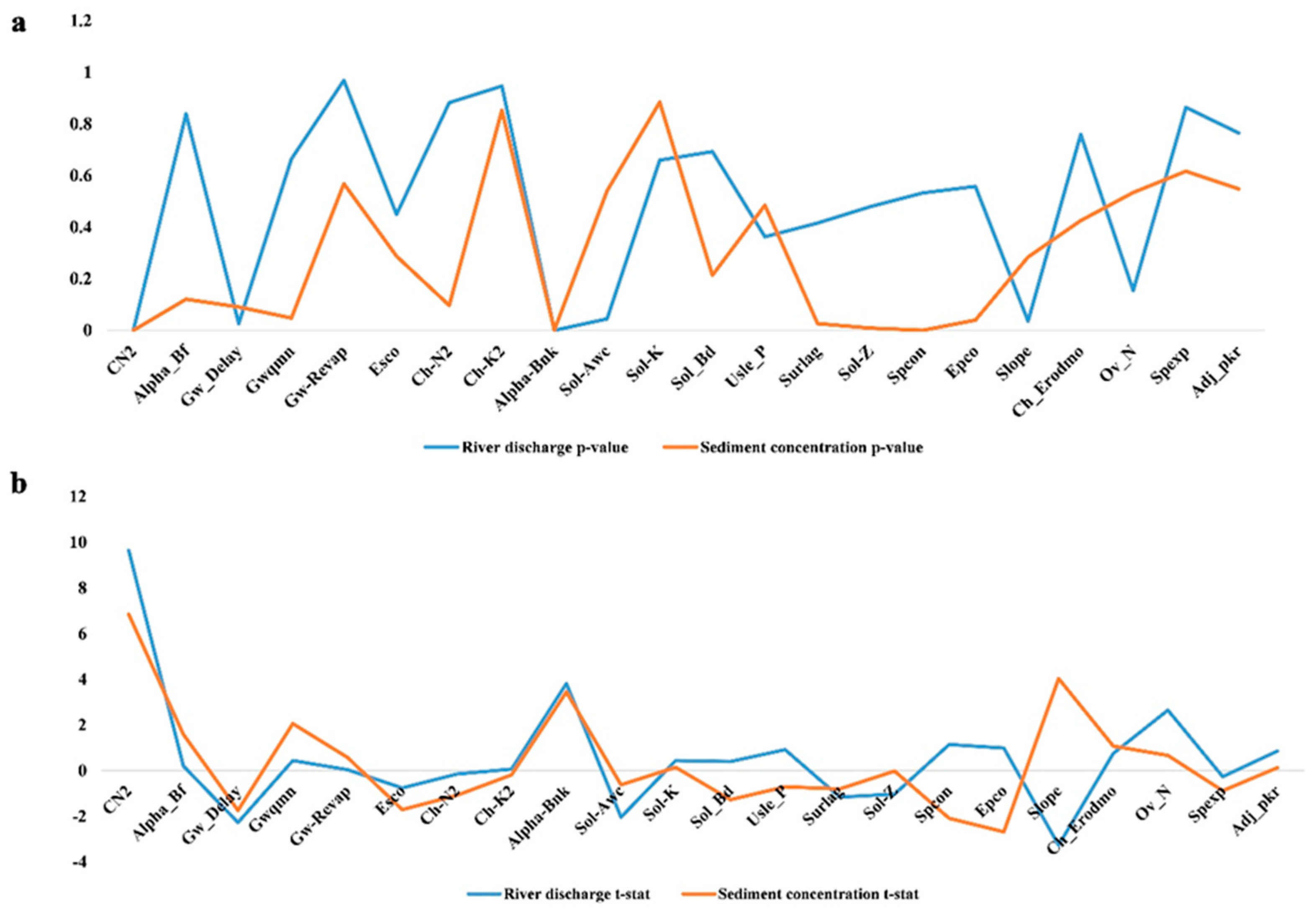
Figure 6.
Observed and simulated monthly discharge in a) calibration; b) validation period.
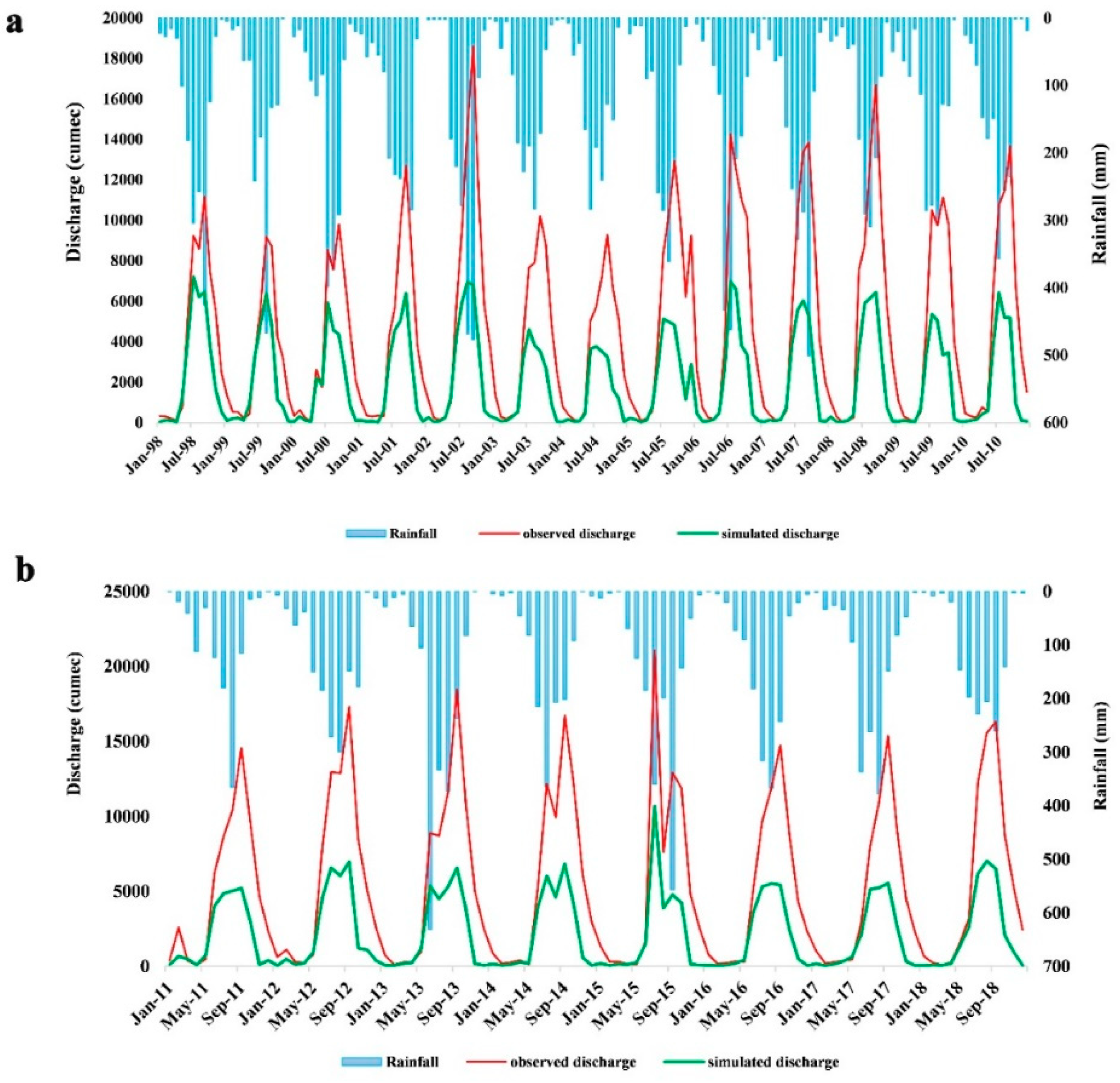
Figure 7.
Observed and simulated monthly sediment yield in a) calibration and b) validation period.
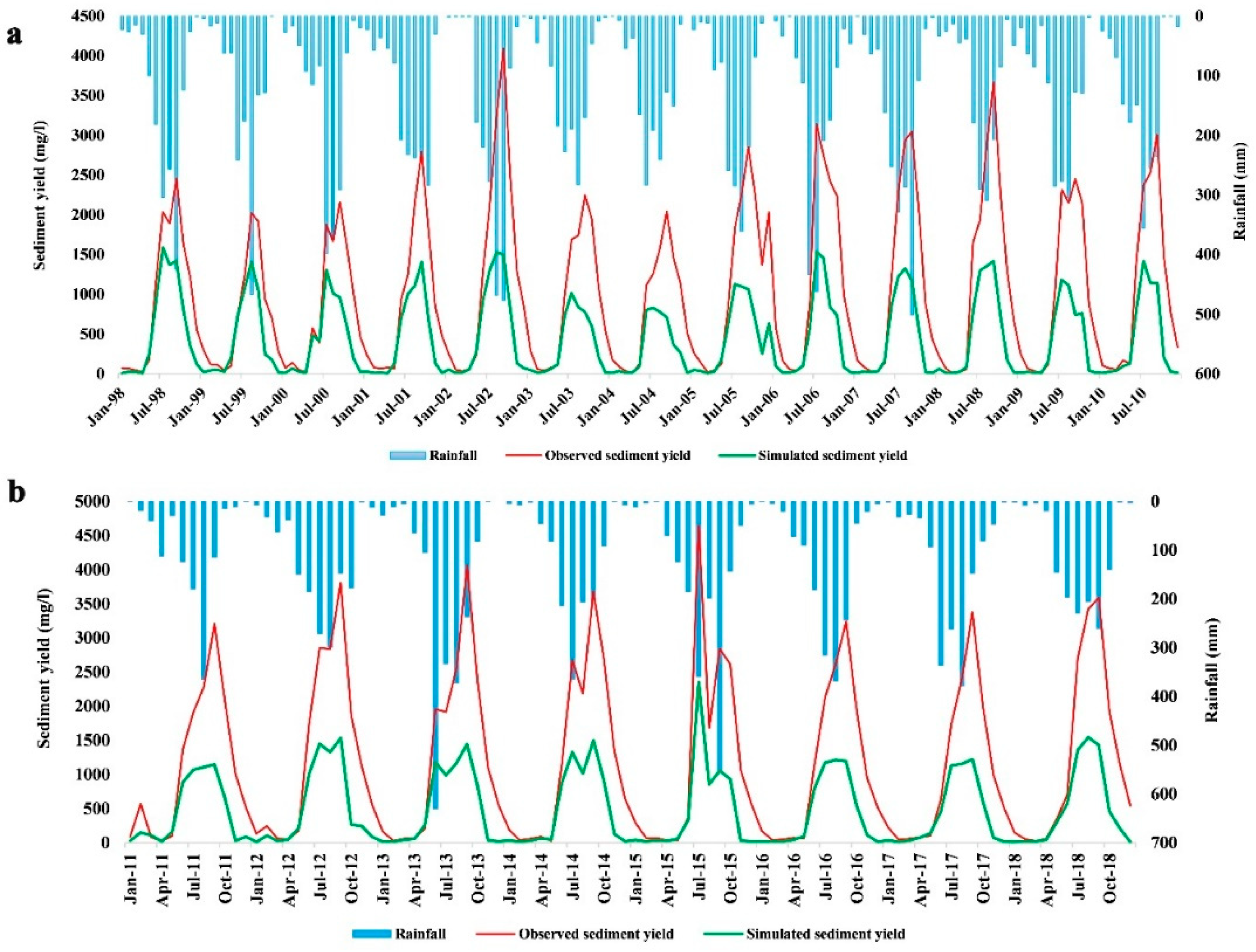
Figure 8.
River discharge uncertainty after simulation with calibration and validation period.
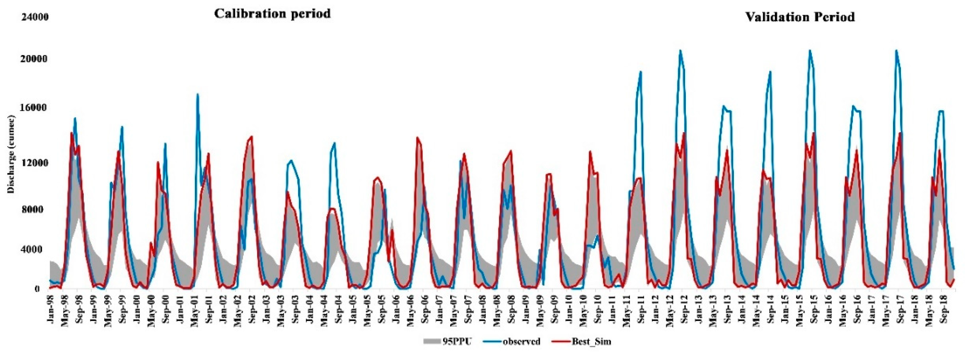
Figure 9.
Sediment yield uncertainty after simulation with calibration and validation period.
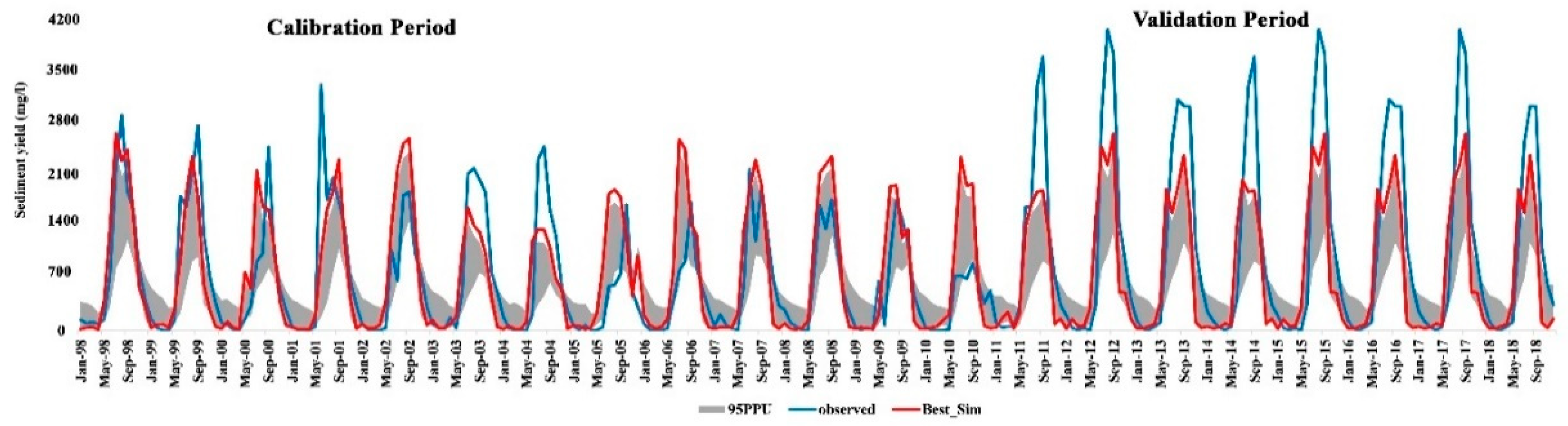
Figure 10.
Correlation between calibrated and validated results on river discharge and sediment yield.
Figure 10.
Correlation between calibrated and validated results on river discharge and sediment yield.
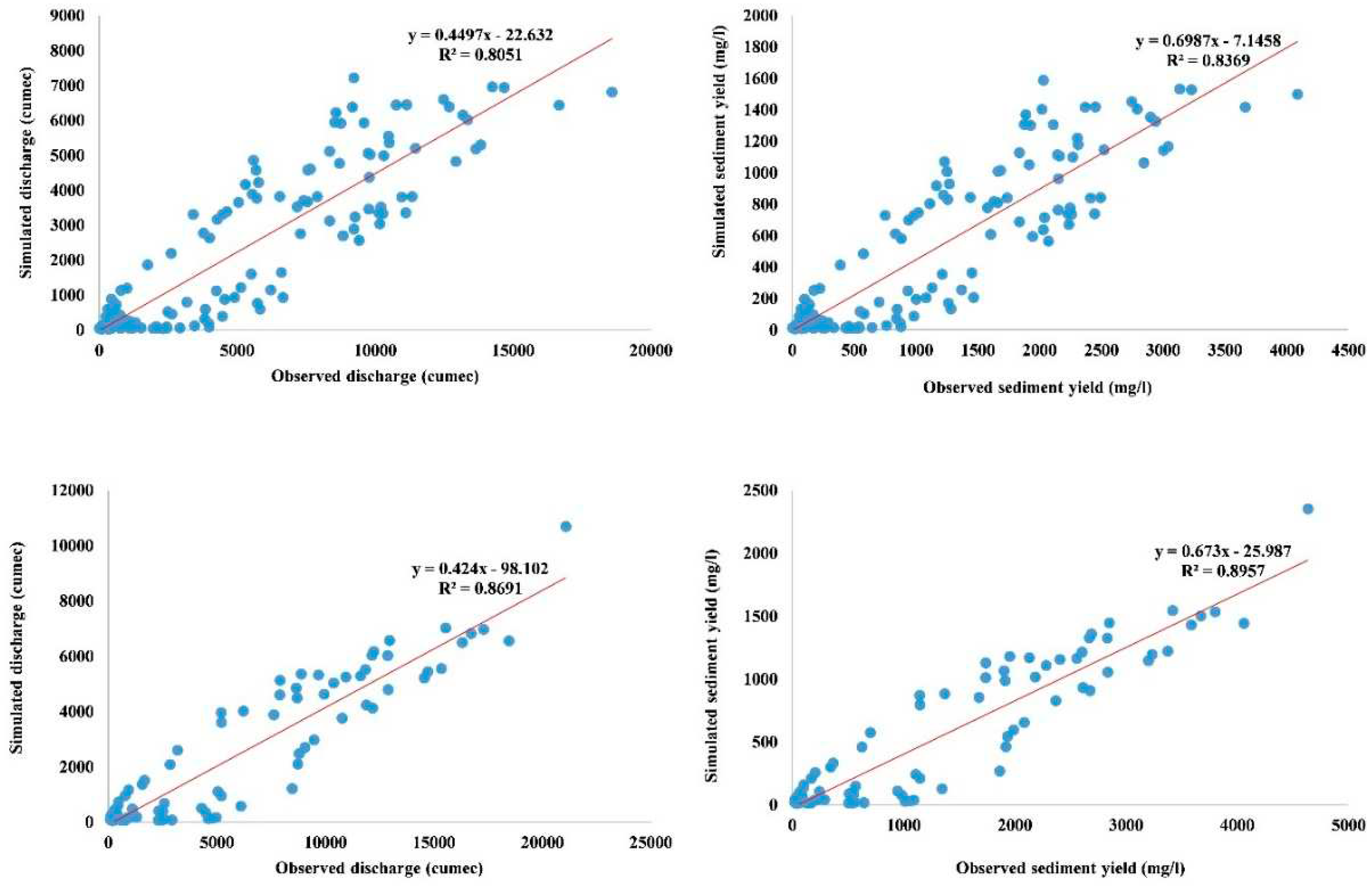
Figure 11.
Monthly average water balance of sub-catchment basin by SWAT model.
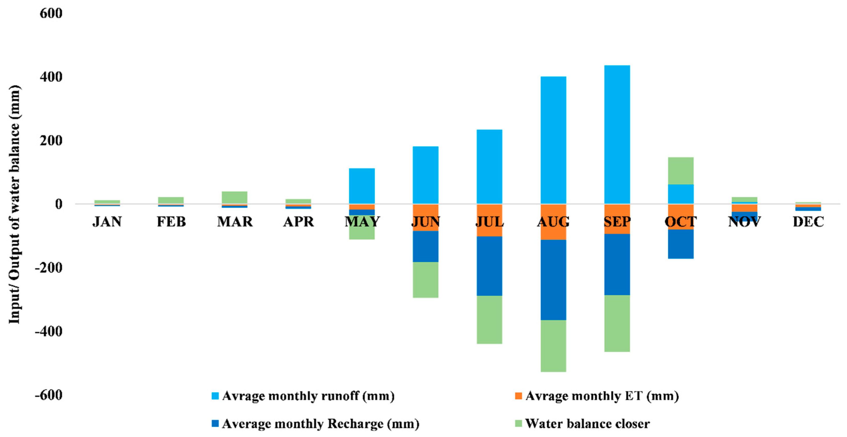

Table 1.
Ranking of SWAT parameter with sensitivity.
| Parameter with acronym | Parameter Name | Min value | Max value | Fitted value | Discharge sensitivity rank | Sediment concentration sensitivity rank |
|---|---|---|---|---|---|---|
| CN2 | Curve number | -0.2 | 0.2 | 0.186 | 5 | 5 |
| Alpha_Bf | Base flow alpha factor | 0 | 1 | 0.145 | 2 | 18 |
| Gw_Delay | Delay time of groundwater supply flow | 30 | 450 | 57.29 | 8 | 20 |
| Gwqmn | Shallow aquifer’s threshold water depth to return flow to occur | 0 | 2 | 0.19 | 11 | 12 |
| Gw¬¬_Revap | Groundwater revap coefficient | 0 | 0.2 | 0.129 | 1 | 22 |
| Esco | Compensation factor for evaporation from soil | 0.8 | 1 | 0.81 | 13 | 15 |
| Ch_N2 | Manning coefficient in the main channel | 0 | 0.3 | 0.211 | 9 | 3 |
| Ch_K2 | Hydraulic conductivity in the main channel | 5 | 130 | 78.13 | 6 | 2 |
| Alpha_Bnk | Baseflow alpha factor for bank storage | 0 | 1 | 0.625 | 16 | 15 |
| Sol_Awc | Available water capacity of soil layer | -0.2 | 0.4 | 0.085 | 3 | 22 |
| Sol_K | Saturated hydraulic conductivity | -0.8 | 0.8 | -0.456 | 12 | 16 |
| Sol_Bd | Density of soil mass | -0.5 | 0.6 | 0.518 | 10 | 11 |
| Usle_P | Factor related to soil conservation operations in the USLE equation | 0 | 1 | 0.45 | 14 | 14 |
| Surlag | Surface runoff lag coefficient | 0 | 10 | 7.51 | 7 | 6 |
| Sol_Z | Depth from soil surface to bottom layer | -25 | 25 | 4.23 | 4 | 13 |
| Spcon | Linear parameter for calculating sediment re-entrained in channel sediment routing | 0.0001 | 0.01 | 0.0067 | 15 | 1 |
| Epco | Plant uptake compensation factor | 0 | 1 | 0.58 | 19 | 17 |
| Slope | Tributary channel’s average slope | 0 | 5 | 2.14 | 17 | 4 |
| Ch_Erodmo | Channel erodibility coefficient | 0 | 1 | 0.61 | 18 | 7 |
| Ov_N | Coefcient of roughness of range | -0.5 | 0.5 | 0.29 | 21 | 8 |
| Spexp | Exponential re-entrainment coefficient for channel sediment routing | 1 | 1.5 | 1.34 | 22 | 9 |
| Adj_pkr | Peak rate adjustment factor for sediment routing in sub-basin | 0.5 | 2 | 1.87 | 20 | 10 |
Table 2.
Annual average water balance (sub-basin wise).
| Sub-basin | Area (km2) | Rain (mm) | Surface runoff (mm) | Ground water movement (mm) | Total water yield (mm) | ET (mm) | Sediment (t/ha) |
|---|---|---|---|---|---|---|---|
| 1 | 369.5 | 1224 | 1025 | 53.25 | 363.57 | 336.47 | 33.54 |
| 2 | 401.3 | 1362 | 1147 | 47.24 | 457.81 | 408.53 | 39.14 |
| 3 | 321.4 | 1174 | 968 | 63.44 | 364.22 | 367.41 | 29.47 |
| 4 | 85.7 | 1284 | 1074 | 84.75 | 485.12 | 412.47 | 32.64 |
Table 3.
Average annual water balance in sub-catchment area (monthly).
| Month | Rainfall (mm) | Surface runoff (mm) | Ground water movement (mm) | Total water yield (mm) | ET (mm) | Sediment (t/ha) |
|---|---|---|---|---|---|---|
| January | 1.94 | 0.23 | 0.07 | 0.35 | 3.25 | 0.01 |
| February | 1.45 | 0.35 | 0.08 | 0.47 | 4.15 | 0.01 |
| March | 1.46 | 0.48 | 0.14 | 0.81 | 5.96 | 0 |
| April | 1.68 | 0.96 | 0.21 | 0.91 | 7.41 | 0 |
| May | 178.48 | 112.36 | 2.54 | 32.41 | 17.42 | 0 |
| June | 219.78 | 180.95 | 3.24 | 88.74 | 31.24 | 14.2 |
| July | 277.78 | 234.15 | 5.74 | 101.36 | 42.85 | 22.4 |
| August | 467.91 | 401.36 | 6.39 | 157.41 | 51.42 | 27.8 |
| September | 476.79 | 435.21 | 5.41 | 74.81 | 31.74 | 34.2 |
| October | 87.84 | 61.47 | 3.24 | 12.36 | 15.24 | 21.4 |
| November | 17.86 | 5.84 | 0.04 | 3.24 | 2.54 | 0 |
| December | 0.11 | 0.09 | 0.005 | 0.006 | 1.14 | 0 |
Disclaimer/Publisher’s Note: The statements, opinions and data contained in all publications are solely those of the individual author(s) and contributor(s) and not of MDPI and/or the editor(s). MDPI and/or the editor(s) disclaim responsibility for any injury to people or property resulting from any ideas, methods, instructions or products referred to in the content. |
© 2024 by the authors. Licensee MDPI, Basel, Switzerland. This article is an open access article distributed under the terms and conditions of the Creative Commons Attribution (CC BY) license (http://creativecommons.org/licenses/by/4.0/).
Copyright: This open access article is published under a Creative Commons CC BY 4.0 license, which permit the free download, distribution, and reuse, provided that the author and preprint are cited in any reuse.


