Submitted:
08 January 2024
Posted:
15 January 2024
You are already at the latest version
Abstract
The proposed research study explore the decision tool for cropwise variability of NDVI using RS techniques and GIS tool as a crucial indicators for monitoring vegetation status.A small case study for Parbhani district of Maharashtra, India was conducted using Landsat-9 satellite images of the Rabi season in the year 2022-23 were processed using ArcGIS 10.7 software to derive the NDVI values. During the analysis, the maximum NDVI in the study area was recorded at 0.5857 on February 03, 2023, while the minimum was observed as -0.1018 on February 19, 2023. For specific crops, the average NDVI ranged from 0.1183 to 0.3189 for wheat, 0.1679 to 0.2891 for jowar, and 0.1163 to 0.3367 for gram. The mean NDVI values for wheat, jowar, and gram crops during the Rabi season of 2022-23 were 0.218, 0.219, and 0.217, respectively.Furthermore, the average NDVI values exhibited an increasing from the initial stage to the mid-crop growth stage, followed by a decrease during the end-season stage for wheat, jowar, and gram crops. Interestingly, the mean NDVI values of major Rabi crops, wheat, jowar, and gram for the year 2022-23, is approximately similar to the mean NDVI values observed for of year 2022-23.
Keywords:
Temporal variation
; Vegetation Index
; NDVI
; Landsat 9
Introduction
Remote sensing involves the scientific and artistic process of acquiring data related to specific objects, regions, or phenomena such as agricultural land, urban areas, vegetation, and water resources. It entails capturing features in the form of spectral, spatial, and temporal information about these entities, all without direct physical contact. (Karaburun and Bhandari (2010) [4]. Utilizing multi-spectral remote sensing images provides a valuable method for obtaining improved insights into the Earth's environment (M Govender 2009) [3]. The utilization of remote sensing techniques includes the computation of the Normalized Difference Drought Index (NDDI), which is derived from both the Normalized Difference Vegetation Index (NDVI) and Normalized Difference Water Index (NDWI). When comparing NDVI and NDWI, higher values were identified in Parbhani district during regular rainy conditions in 2020, while contrasting lower values were observed in 2015 Patil et.al,(2023) [7]. The Normalized Difference Vegetation Index (NDVI) is a significant marker for gauging plant growth and plays a pivotal role in assessing related biophysical factors like leaf area index (LAI), biomass, photosynthetic activity, and grain yields. In particular, NDVI is crucial in tracking vegetation stress, where surface temperatures (Ts) act as an informative gauge for water stress. Several researchers have delved into the prospect of deriving soil moisture and water stress data by investigating the correlation between remotely sensed Ts and NDVI in their investigations. (Sruthi and Aslam) [12]. This study was conducted in the Parbhani district of Maharashtra, India, where remote sensing was employed to assess the vegetation status.
Top of Form
Material and Method
Study area
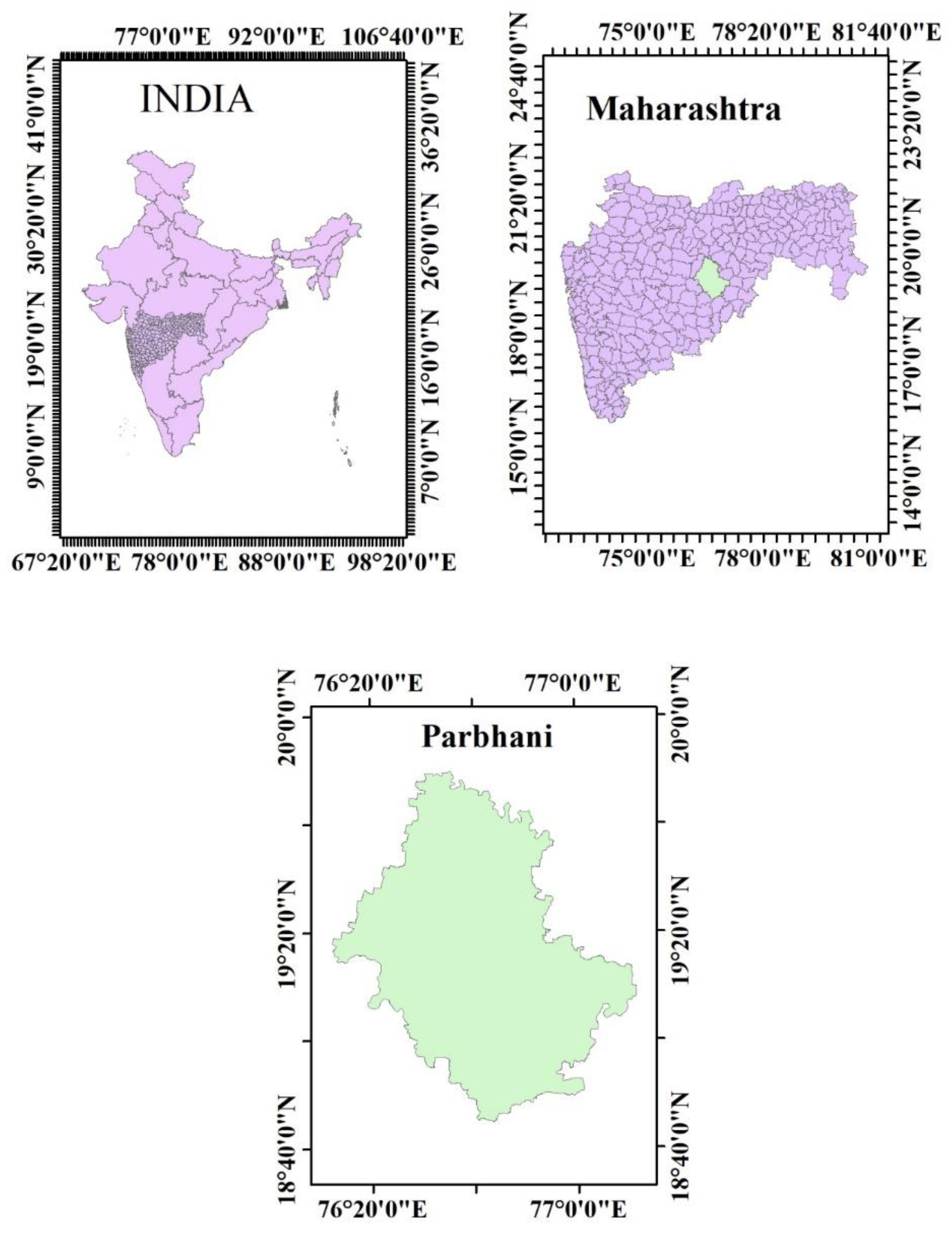
Parbhani, situated in the Marathwada region of Maharashtra, is a district encompassing the geographical coordinates of 18.45 to 20.10 North latitudes and 76.13 to 77.39 East longitude. It shares its borders with Hingoli district to the north, Nanded district to the east, Latur to the south, and Parbhani and Jalna districts to the west. Encompassing an area of approximately 6250.58 km2, Parbhani district occupies a significant space within the state.
Figure 1.
Study Area Map.
Collection of Field Data
Ground truthing point (GT) data for winter crops in various villages of Parbhani district were gathered at multiple points corresponding to different developmental phases of the crops. Using Landsat-9 satellite imagery, large homogeneous areas were identified for wheat, jowar, and gram, each with different density classes. The study extensively focused on key Rabi crops—wheat, jowar, and gram. Specific locations for these crops were pinpointed to retrieve the relevant Normalized Difference Vegetation Index (NDVI). Among the selected locations, wheat was found at 42 points, jowar at 36 points, and gram at 63 points. Additionally, seven locations were designated for waste land or build-up areas.
Collection of Satellite Data
This research utilized satellite data spanning the October 2022 to February 2023, obtained from the USGS Earth Explorer (NASA LPDAAC Collection), a freely available repository of satellite data. [6] In the present study, Landsat 9 data having eleven bands out of which one in visible range and two in infra-red range used for estimation of vegetation indices.
Temporal satellite images from Landsat 9 were acquired through the USGS website (www.earthexplorer.usgs.gov) for the study area, specifically Path: 145, Row: 46, and Path: 145, Row: 47. The Landsat 9 satellite, equipped with the Operational Land Imager (OLI) and Thermal Infrared Sensor (TIRS), was launched on September 27, 2021, capturing Earth images with a 16-day repeat cycle. The scenes have an approximate size of 170 km north-south by 183 km east-west. Landsat 9 provides spectral band files in GeoTIFF format, and ESRI's ArcGIS-ArcMap 10.7 was the chosen Remote Sensing and GIS software for the study. Table 1 provides details on the different resolutions of Landsat-9.
Methodology
Rouse et al. (1973) [10] Proposed the idea of the Normalized Difference Vegetation Index (NDVI). The Normalized Difference Vegetation Index (NDVI) is computed from reflectance data obtained in the visible and near-infrared spectral bands. Utilizing the visible and near-infrared bands, NDVI assesses the abundance and vitality of green vegetation by evaluating the ratio of reflected visible light to reflected near-infrared light. NDVI values range between -1 to +1. In which +1 value indicates highest possible density of vegetation, zero and below zero NDVI value indicating low or no green vegetation. Areas of barren rock, sand, and snow produce NDVI values of 0.1 or less, while shrub and grassland typically produce NDVI values of 0.2-0.3, and temperate and tropical rainforests produce values in the 0.6-0.8 range, NDVI values are spatially dependent on climate, soil, and topography and hence, more productive ecosystems have different radiometric properties than less productive ones (Quiring and Ganesh, 2010). [8] The raster calculator of ArcGIS 10.7 was used to prepare the NDVI map for Landsat images. The NDVI map for Landsat images was generated using the raster calculator in ArcGIS 10.7. The foundation of the Normalized Difference Vegetation Index (NDVI) lies in the recognized radiation characteristics of plants, utilizing both visible (red) and near-infrared (NIR) radiation. The concept was introduced by Deering [2] and Tucker [1], with the ratio expressed in Equation.
Where,
NIR= Reflectance in the near-infrared band
R= Reflectance in the red visible band
Results and Discussion
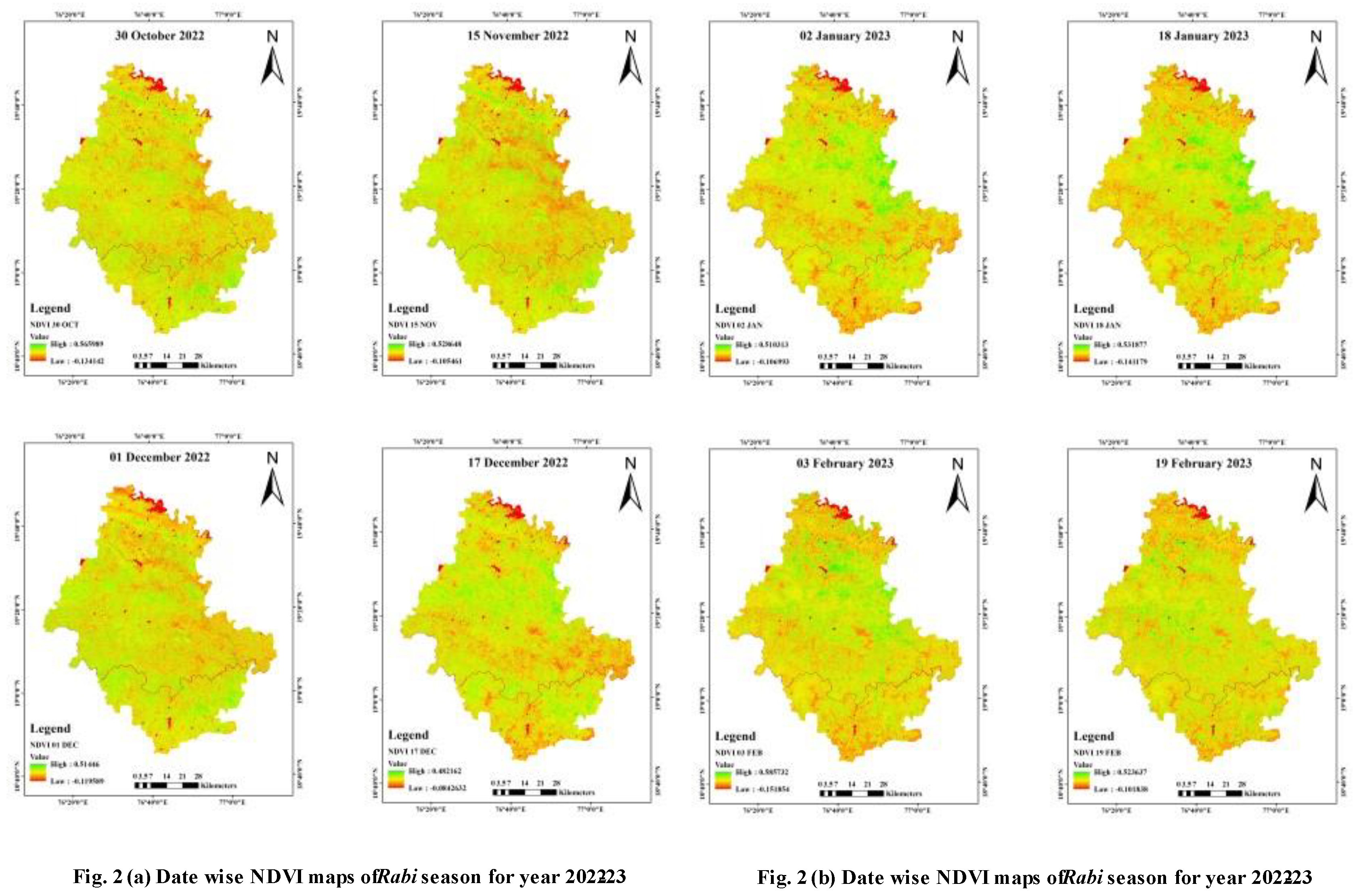
The investigation utilized the Normalized Difference Vegetation Index (NDVI) to explore the connection between spectral vegetation variability and changes in vegetation growth rate. Higher NDVI values were shows a sign of vigorous and healthier vegetation, whereas lower values were shows to less vegetation. This phenomenon was attributed to the heightened reflection from the soil, resulting in low values in the near-infrared band and high values in the red band, thereby leading to lower NDVI values. NDVI maps were created for Landsat-9 images acquired on different dates i.e., October 30, 2022; November 15, 2022; December 01, 2022; December 17, 2022; January 02, 2023; January 18, 2023; February 03, 2023; February 19, 2023.
In the Rabi season of 2022-23, the NDVI values in the study area exhibited a range from -0.1341 to 0.566 on October 30, 2022; -0.1055 to 0.5286 on November 15, 2022; -0.1196 to 0.5145 on December 01, 2022; -0.0843 to 0.4822 on December 17, 2022; -0.107 to 0.5103 on January 02, 2023; -0.1412 to 0.5319 on January 18, 2023; -0.1519 to 0.5857 on February 03, 2023; and -0.1018 to 0.5236 on February 19, 2023. Figure 2(a) and (b) illustrate that the maximum NDVI in the study area was recorded at 0.5857 on February 03, 2023, while the minimum was -0.1018 on February 19, 2023.
The peak NDVI value of 0.585, represented by the green color in the map, was observed on February 19, 2023, followed by a subsequent decrease in values. This peak NDVI was predominantly observed in areas with dense vegetation compared to other land uses, as reported by Rizvi et al. (2009) [8].
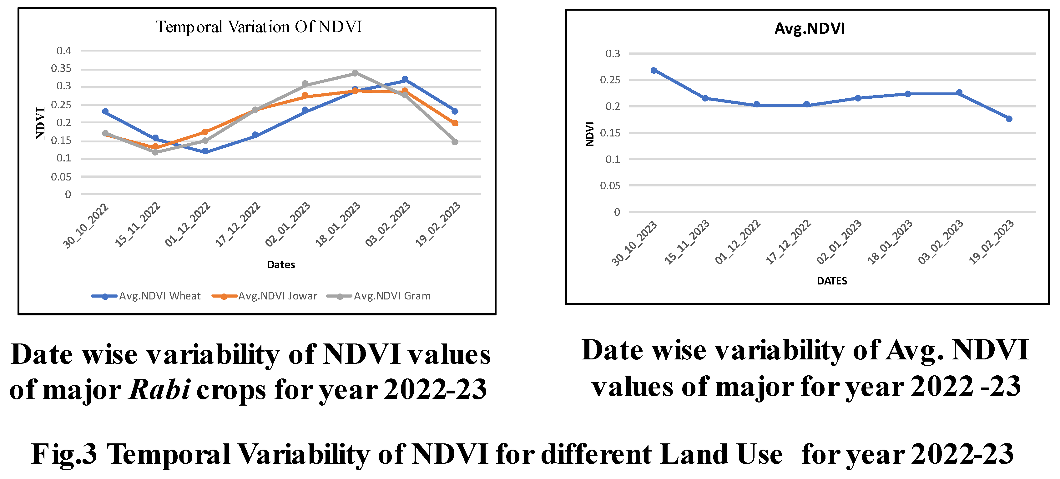
The average NDVI values for specific crops varied, ranging from 0.1183 to 0.3189 for wheat, 0.1679 to 0.2891 for Jowar, and 0.1163 to 0.3367 for Gram. The mean NDVI values for wheat, jowar, and gram crops during the Rabi season of 2022-23 were 0.218, 0.219, and 0.217, respectively, as depicted in Figure 3. This aligns with the findings of Koppada and Janagoudarb (2017) [5], who reported NDVI values for cropped land between 0.14-0.37, indicating a decrease during the harvesting stage.
Furthermore, the NDVI map highlighted that the maximum crop area was noted in January, with a subsequent decrease as a result of harvesting. The minimum area with higher NDVI values was noted in February 2023.
Figure 3 depicting the NDVI values of various Rabi crop sites, determined through field data, were generated utilizing multi-date landsat-9 data as outlined by Şekertekin et al. (2018) [11] at diverse locations within the chosen villages.Top of Form
A comprehensive investigation was conducted focusing on the major Rabi crops, wheat, jowar, and gram. Pinpoint locations were meticulously identified for each of these crops to extract corresponding NDVI values. Among the selected locations, wheat, jowar, and gram were found at 42, 36, and 63 sites, respectively, while 7 locations were designated for waste land or built-up areas.
The average NDVI values for wheat, jowar, and gram were calculated for each date throughout the Rabi season of the year 2022-23. The NDVI data extracted for each specific crop contributed to the determination of crop-wise NDVI values for every selected date. Table 2 presents these crop-wise NDVI values for each date, alongside the mean NDVI value for the entire Rabi season.
Conclusions
The wheat crop exhibited an average NDVI ranging from 0.1183 to 0.3189, while the Jowar crop showed values between 0.1679 and 0.2891. For the Gram crop, the NDVI ranged from 0.1163 to 0.3367. The mean NDVI values for wheat, jowar, and gram crops during the Rabi season of 2022-23 were 0.218, 0.219, and 0.217, respectively, as detailed in Table 2.
In the case of wheat, jowar, and gram crops, the NDVI demonstrated an increase up to 0.3189, 0.2891, and 0.3367, respectively, from October 30, 2022, to February 19, 2023. Subsequently, the NDVI values showed a decline towards the end of the crop season.
The mean NDVI values of major Rabi crops i.e., wheat, jowar and gram for 2022-23 was observed as 0.218, 0.219 and 0.217 respectively as shown in Table 2. As the mean NDVI values of major Rabi crops for year 2022-23 is approximately similar to the mean NDVI values observed for of year 2022-23.
Acknowledgments
We thankful to NAHEP, Parbhani and ICAR, to arranging international training on GIS at Asian institute technology, Thailand. To provide financial support and tankful to NAHEP and AIT Staff and Professors.
References
- C. Tucker, Iw % SA technical memorandum 79620 combinations for monitoring vegetation, Remote Sens. Environ. 8 (1979) 127–150.
- D.W. Deering, rangeland reflectance characteristics measured by aircraft and spacecraft sensors, Graduate College of Texas A&M University, 1978.
- 3. Govender, M., Govender, P. J., Weiersbye, I. M., Witkowski, E. T. F., & Ahmed, F. (2009). Review of commonly used remote sensing and ground-based technologies to measure plant water stress. Water Sa, 35(5). [CrossRef]
- Karaburun, A. (2010). Estimation of C factor for soil erosion modeling using NDVI in Buyukcekmece watershed. Ozean Journal of applied sciences, 3(1), 77-85.
- Koppad, A. G., & Janagoudar, B. S. (2017). Vegetation analysis and land use land cover classification of forest in Uttara Kannada district India through geo-informatics approach. The International Archives of the Photogrammetry, Remote Sensing and Spatial Information Sciences, 42, 219-223. [CrossRef]
- NASA, EarthExplorer, NASA LPDAAC collect. 2022. Available online: https://earthexplorer.usgs.gov/ (accessed on 16 February 2023).
- Patil, P. P., Jagtap, M. P., Khatri, N., Madan, H., Vadduri, A. A., & Patodia, T. (2023). Exploration and advancement of NDDI leveraging NDVI and NDWI in Indian semi-arid regions: A remote sensing-based study. Case Studies in Chemical and Environmental Engineering, 100573. [CrossRef]
- Quiring, S. M., & Ganesh, S. (2010). Evaluating the utility of the Vegetation Condition Index (VCI) for monitoring meteorological drought in Texas. Agricultural and forest meteorology, 150(3), 330-339. [CrossRef]
- Rizvi, R. H., Yadav, R. S., Singh, R., Datt, K., Khan, I. A., & Dhyani, S. K. (2009, September). Spectral analysis of remote sensing image for assessment of agroforestry areas in Yamunanagar district of Haryana. In National Symposium on “Advances in Geo-spatial Technologies with Special Emphasis on Sustainable Rainfed Agriculture”, RRSSC, Nagpur (Vol. 7).
- Rouse Jr, J. W., Haas, R. H., Schell, J. A., & Deering, D. W. (1973). Monitoring the vernal advancement and retro gradation (green wave effect) of natural vegetation (No. NASA-CR-132982).
- Şekertekin, A., Marangoz, A. M., & Abdikan, S. (2018). Soil moisture mapping using Sentinel-1A synthetic aperture radar data. International Journal of Environment and Geoinformatics, 5(2), 178-188. [CrossRef]
- Sruthi, S., & Aslam, M. M. (2015). Agricultural drought analysis using the NDVI and land surface temperature data; a case study of Raichur district. Aquatic Procedia, 4, 1258-1264. [CrossRef]

Table 1.
Band Designation.
| Sr. No. | Band | Wavelength (mm) | Spatial Resolution (meter) | Sr. No. | Band | Wavelength (mm) | Spatial Resolution (meter) |
|---|---|---|---|---|---|---|---|
| 1. | Band 1-costal Aerosol | 0.43- 0.45 | 30 | 7. | Band 7 SWIR 2 | 2.11- 2.29 | 30 |
| 2. | Band 2- Blue | 0.45- 0.51 | 30 | 8. | Band 8 Panchromatic | 0.50 - 0.68 | 15 |
| 3. | Band 3 Green | 0.53- 0.59 | 30 | 9. | Band 9 Cirrus | 1.363-1.384 | 30 |
| 4. | Band 4 Red | 0.64- 0.67 | 30 | 10. | Band 10 Thermal Infrared (TIRS) 1 | 10.60- 11.19 | 100× (30) |
| 5. | Band 5(NIR) | 0.85- 0.88 | 30 | 11. | Band 11 Thermal Infrared (TIRS) 2 | 11.50-12.51 | 100× (30) |
| 6. | Band 6 SWIR 1 | 1.57- 1.65 | 30 |
Table 2.
Temporal fluctuations in the Normalized Difference Vegetation Index (NDVI) values for major Rabi crops during the year 2022-23, documented on a date-wise basis.
Table 2.
Temporal fluctuations in the Normalized Difference Vegetation Index (NDVI) values for major Rabi crops during the year 2022-23, documented on a date-wise basis.
| Dates | Wheat | Jowar | Gram | Avg. Mean |
|---|---|---|---|---|
| 30_10_2022 | 0.229 | 0.168 | 0.169 | 0.268 |
| 15_11_2022 | 0.156 | 0.131 | 0.116 | 0.216 |
| 01_12_2022 | 0.118 | 0.173 | 0.149 | 0.203 |
| 17_12_2022 | 0.164 | 0.235 | 0.235 | 0.209 |
| 02_01_2023 | 0.234 | 0.275 | 0.306 | 0.214 |
| 18_01_2023 | 0.291 | 0.289 | 0.337 | 0.224 |
| 03_02_2023 | 0.319 | 0.286 | 0.275 | 0.220 |
| 19_02_2023 | 0.232 | 0.196 | 0.145 | 0.176 |
| Mean | 0.218 | 0.219 | 0.217 |
Disclaimer/Publisher’s Note: The statements, opinions and data contained in all publications are solely those of the individual author(s) and contributor(s) and not of MDPI and/or the editor(s). MDPI and/or the editor(s) disclaim responsibility for any injury to people or property resulting from any ideas, methods, instructions or products referred to in the content. |
© 2024 by the authors. Licensee MDPI, Basel, Switzerland. This article is an open access article distributed under the terms and conditions of the Creative Commons Attribution (CC BY) license (http://creativecommons.org/licenses/by/4.0/).
Copyright: This open access article is published under a Creative Commons CC BY 4.0 license, which permit the free download, distribution, and reuse, provided that the author and preprint are cited in any reuse.


