I. Introduction
Mound-building red wood ants (hereafter RWA) of the Formica rufa group hold a special ecological position in forest ecosystems. Besides their role in reducing pest insects (Reisch, 2013), they contribute to conserving biodiversity by dispersing seeds (Nierhaus-Wunderwald, 1995). Additionally, they serve as a food source for various bird species, such as woodpeckers (Piciformes) and galliform birds (Galliformes) (Seifert, 2008; Nicolai, 2018). For these reasons, RWA populations have been early subjects of protection in Germany under the Federal Species Protection Regulation (2005) and the Federal Nature Conservation Act (2009).
Interestingly, when examining large areas, RWA populations may be spread extremely unequally despite seemingly similar ecological conditions. For forest and nature conservation purposes relocation of RWA to achieve a more even distribution was common in Germany. These efforts have been problematic and very often unsuccessful. The underlying reasons can be attributed to both methodological issues and incorrect site selection (Wellenstein, 1990). Therefore, a more detailed understanding of the habitat requirements of RWA is of particular interest.
There is broad consensus that the settlement sites of RWA vary depending on climatic factors (sunshine duration and temperature), terrain characteristics (soil properties, elevation, aspect, and slope), as well as food availability, vegetation (stand type and structure), and management practices (Vandegehuchte et al., 2017). They prefer coniferous forests, but they can also be found in deciduous stands. They even utilize hedges along inhabited properties and grassy road edges in urban areas. Nevertheless, RWA are often absent in large areas despite the presence of the considered relevant ecological factors. Conversely, RWA occasionally occur in extremely high densities in otherwise homogeneous forested regions, suggesting the involvement of overlooked favorable factors.
Schreiber et al. (2009) consider additional factors, such as indicator gases that ascend to the surface along permeable geological fault systems. Field investigations in several regions of Central Europe have demonstrated that the more frequently occurring linear distributions and aggregations (hotspots) of RWA nests are associated with active gas-permeable tectonic fault zones (Schreiber, 2009; Berberich, Schreiber, 2013; Del Toro et al., 2017). Some level of seismic activity seems to promote these conditions, contributing to gas pathways in the upper crust. Hence, in assessing habitat criteria, attention must be given to not only ecological differentiating factors but also the tectonics, geology, and geomorphological conditions of the nest sites. A significant connection with CO2 emerging from the crust is presumed. Critical factors include: whether a gas-permeable fault extends through the rock units to the surface, whether it is overlaid by porous sediments with or without groundwater flow, or if it is sealed by minerals or clays. Overall, a moderate increase in CO2 concentration in Formica nests can contribute to regulating and stabilizing temperature. This is achieved through both physical effects and a reduction in oxygen concentration within the nests, which limits temperature-elevating oxidation processes. This phenomenon could play a crucial role in maintaining the microclimate within the nests and thus influence the living conditions of the ant community.
The present work is based on a systematic full inventory of RWA conducted by biologists, focusing on the Baar region around Seitingen-Oberflacht in southwest Germany, taking into account the local geological and geomorphological conditions of the sites. The data collection involved collaboration with local forestry authorities and research into municipal records.
II. Materials and methods
II.1 Study area
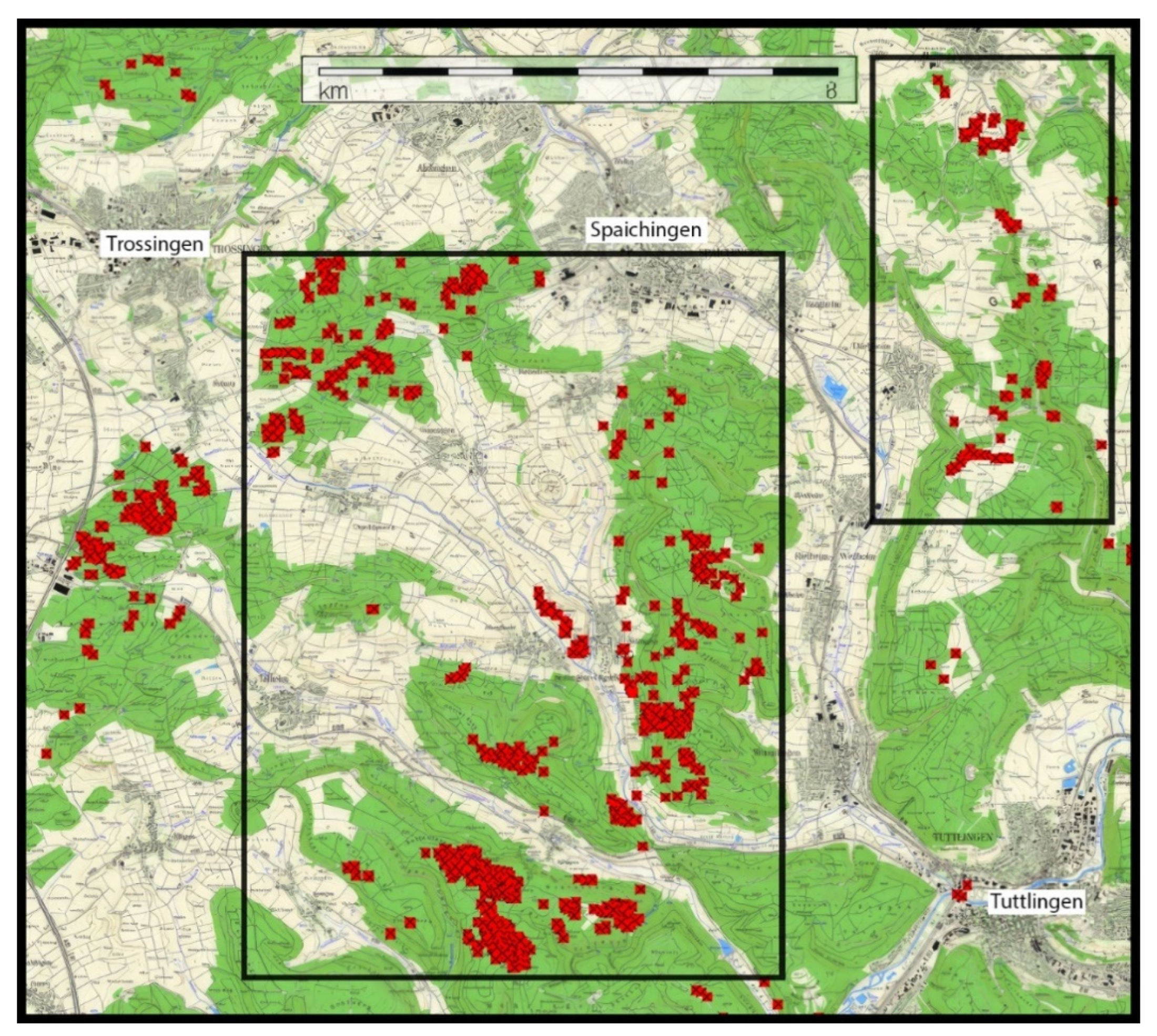
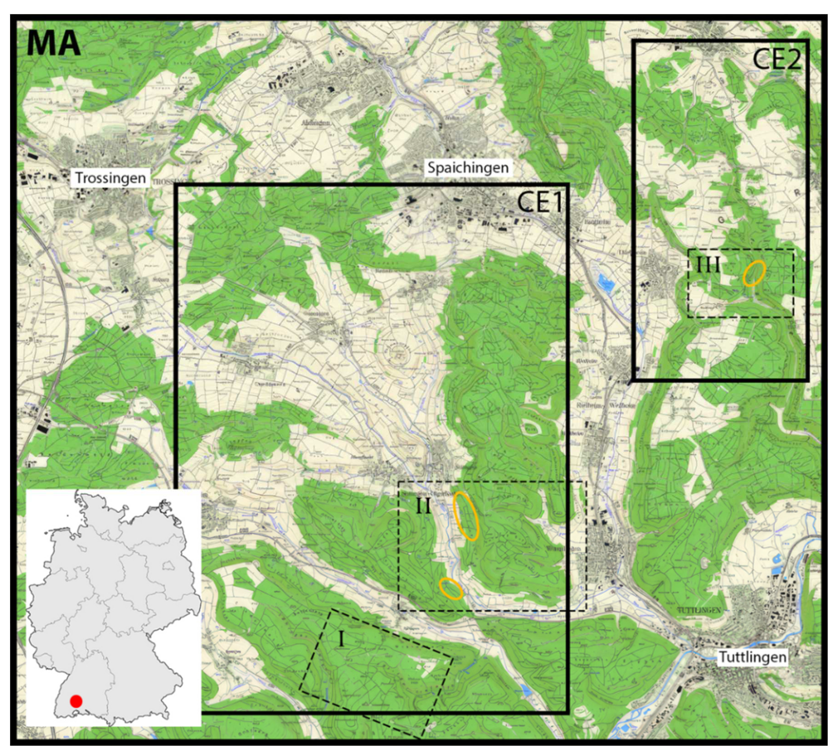
The study area (MA) is located east of the Black Forest in the transitional zone between the High Alb and the northern foreland of the escarpment landscape (Schichtstufenland). It encompasses the regions around Trossingen, Spaichingen, and Tuttlingen, representing the natural landscapes of the Middle Black Forest, Baar, and northern Baaralb (
Figure 1). The region lies within a tectonically active complex junction of two major fault systems, the north-northeast to south-southwest trending Albstadt shear zone (ASZ), and the northwest to southeast trending Freiburg-Bonndorf-Bodensee shear zone (FBBSZ;
Figure 7c). While the outcrops in the study area include the strata of Keuper to Upper Jurassic, the fault zones cut through the crystalline basement and the cover rocks, comprising units from the Middle Buntsandstein to the Upper Jurassic. A morphological peculiarity of this region is isolated prominent ridges and hilltops, which are the result of deep linear erosion incisions into the Jurassic rock sequence of the once continuous Alb plateau. The youngest units at the tops of the ridges consist of hard, flat-lying limestones of the Malm. They, along with the adjoining steep slopes, are consistently forested. The plateaus reach elevations between 800 and 970 m above sea level. In the lower areas between the ridges, less erosion-resistant sedimentary rocks of the Lias and Dogger (shales, marls, sandstones) are exposed, resulting in partly wide valley systems, predominantly used for agriculture. In the northern part of the area, the Malm layers are absent due to erosion, and the sedimentary rocks of the Lias and Dogger occur extensively. As a consequence, a gently undulating morphology has developed at elevations between 700 and 800 m above sea level from the less weathering-resistant layers. Continuous forested areas are located in sections with more pronounced relief, where limestone beds are frequently intercalated within the rock sequences.
The forests predominantly grow on flat and gently sloping terrains. The soils contain surface and occasionally deeper (> 40 cm) free lime due to the underlying carbonate rocks. On the slopes, there is an abundance of limestone scree, transitioning to calcareous weathered loam in lower areas. The moisture content varies from moderately fresh to moderately dry, with parts influenced by stagnant or groundwater being rare. Mull is the dominant humus form. The forest is predominantly composed of spruce-dominated stands, alongside fir and beech stands mixed with other deciduous or coniferous trees. The most dominant tree species, by far, is spruce, followed by beech and fir. With the exception of less represented younger age classes, the remaining stand ages (40 - >120 years) are relatively evenly distributed. The forest is primarily managed as so-called "age-class forest" through a sequence of planting, maintenance, and extensive harvesting. Since the forest inventory in 2006, a small portion of the forests has been managed as continuous forest, with no clear-cutting: during the young growth phase, there is predominantly non-crowned weak wood, followed by a growth phase that is usually moderately wood-rich (stand building stage). In the subsequent rejuvenation phase, strong wood is harvested on a single-stem basis, and the young growth is initiated. In some areas the forest is managed extensively.
II.2 Inventory and data analysis
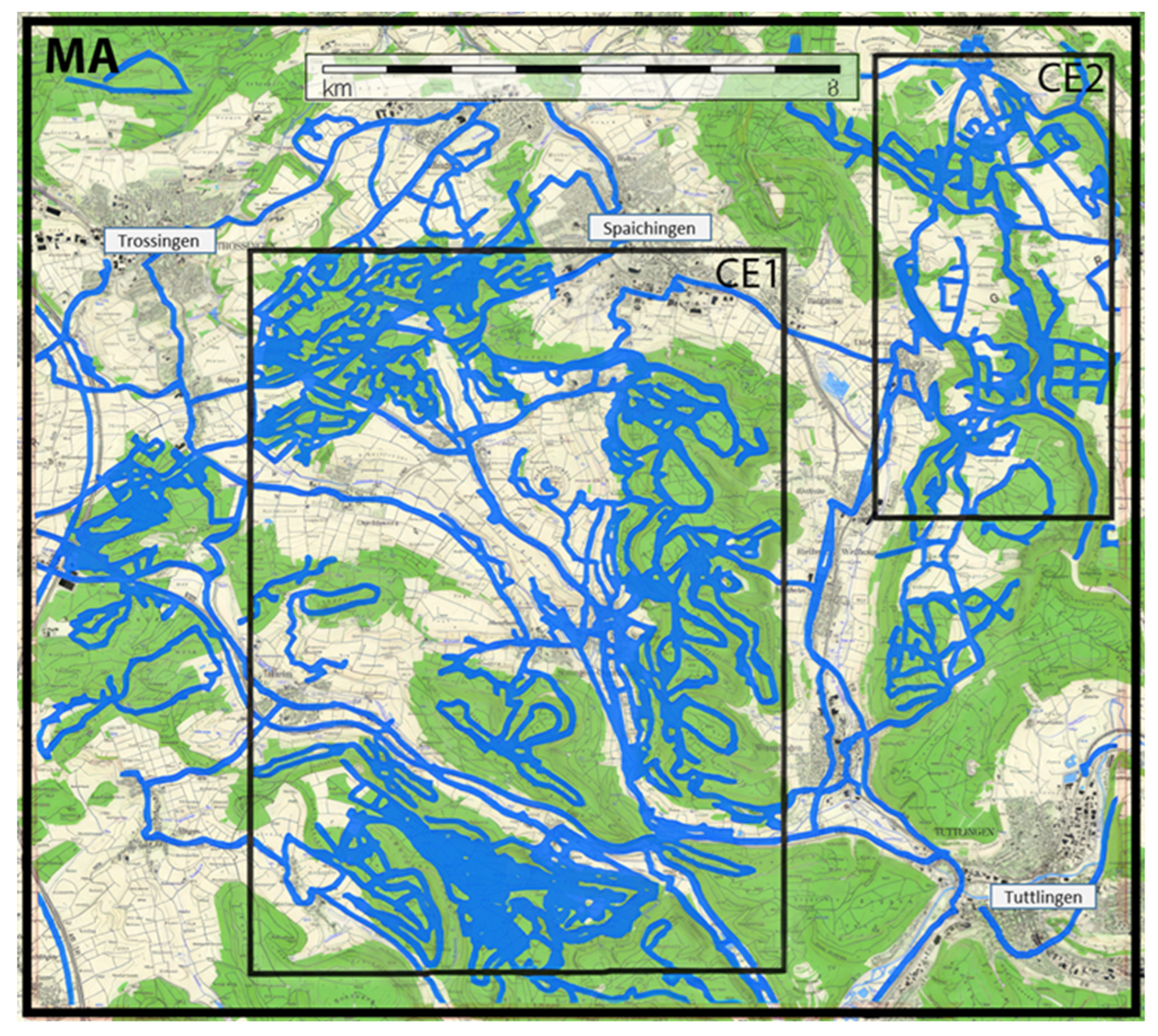
During the vegetation period from May to October, all inhabited RWA nests were inventoried at irregular time intervals. The study areas CE1 and CE2 (
Figure 1) were searched in approximately parallel strips, adjusted in width based on the forest stands and visibility (
Figure 2). Additional information provided by local foresters ensured a comprehensive recording of RWA nests. The position of the nests was recorded using GPS devices (GARMIN GPS map 92, Oregon 550, and 750t), and extensive samples were measured to determine the maximum nest height and average diameter of the nest base. The species identification of the ants was repeatedly determined in the field using a 20x magnification hand lens. In 2021, a selective sampling approach was used, extracting 4 to 7 worker ants directly from the nest surface for subsequent laboratory identification. The determination was performed by D. Klimetzek using a variable stereomicroscope with up to 120x magnification (OLYMPUS SZ) and current identification keys (Seifert, 2007, 2018).
The recording of forestry site conditions in the study area was carried out through field observations and the evaluation of 10-year forest management plans from the forestry offices. Additionally, databases from the Forest Research Institute of Baden-Württemberg (
http://www.fva-bw.de) and the Regional Council of Freiburg (
https://rp.baden-wuerttemberg.de/rpf/abt5/) as well as literature sources were used.
The geological assessment was based on official geological maps with explanations (GM 7918 Spaichingen, 1971, Berz, 1971; GM 7918 Spaichingen, 1995, Berz, 1995; GM 8018 Tuttlingen, 1997, Spitz, 1997; GM 7917 Villingen-Schwenningen-Ost, 2004, Franz, Münzing, 2004) as well as field investigations. Recorded faults in the geological maps and indicators for active fault zones in the field were considered in this evaluation. These indicators include gas emissions, iron colloids (floating iron, Suppl. 1) from CO2-rich waters (Grathoff et al., 2007; Kleja et al., 2012), and sometimes calcite milk streaks on the surface of standing waters over limestone.
To characterize the emerging gases, a Dräger X-am 7000 was used in the field to measure methane and CO2-levels. The device was connected to a metal probe driven 1 meter into the ground. For isotopic determination (δ13C and δ2H) of methane, 20 ml of gas were collected from six gas sources in different morphological positions, including hilltops, slope positions, stream incisions, and swamp areas. The collected gas was transferred to a stainless steel gas sample container. The CH4-isotope analysis was conducted at the Institute for Marine and Atmospheric Research (IMAU) Utrecht (Suppl. 3).
As a model area, the ridge southwest of Esslingen between Reifenberg, Flachhans, Oberer Berg, and Zepfenacker (
Figure 6) was chosen due to a particularly noticeable concentration of nest sites. It was investigated for structures that could indicate faults based on digital terrain data (DGM: Digital Elevation Model) with a 1-meter resolution, obtained from the State Office for Geoinformation and Rural Development (LGL) Baden-Württemberg, Stuttgart (
Figure 6).
III. Results
III.2 Geology and tectonics
III.2.1 Geology of RWA nesting sites
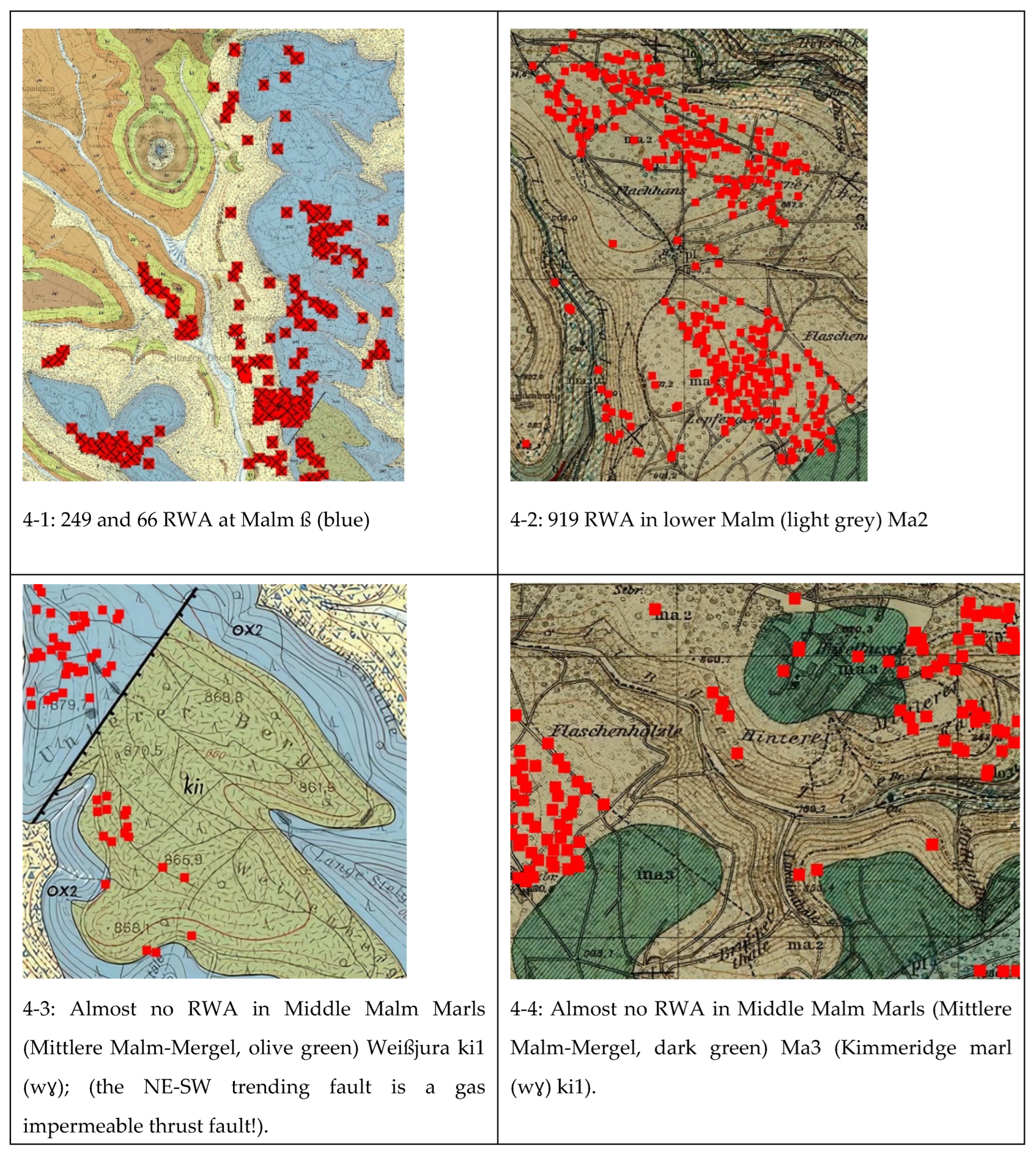
A significant concentration of RWA nests, with 249 and 66 nests, was found in the eastern and southwestern parts, respectively, of Seitingen-Oberflacht, situated between 790 to 953 meters above sea level on the limestone plateaus of the Malm β (Weißjura β, Oxford limestones [wβ] ox2 on GM 7918 Spaichingen, 1995;
Figure 4-1). These plateaus consist of well-layered beds with thicknesses of up to half a meter, reminiscent of a masonry of limestone blocks, separated only by millimeter-thin seams filled with marl. Another area with similar geological conditions, also with high RWA concentration, was observed on the ridge southwest of Esslingen, with 919 nests (Ma2, well-layered limestones, lower Malm;
Figure 4-2).
To the west of Wurmlingen, the Middle Malm marls (Weißjura γ/ki1) overlay this lithological sequence (
Figure 4-3, marly to massive sponge limestones). With the exception of a southwestern fringe (at the boundary of Oxford 2/Kimmeridge 1 - ox2/ki1, or Weißjura β/γ), this unit shows no RWA nests. The same applies to the area south of Esslingen where, except for a small isolated occurrence on a reduced layer, no RWA nests were found in the marls of the Malm γ (middle Malm marls, Ma3 on GM 8018 Tuttlingen, 1997; Kimmeridge marls, wγ ki1 on GM 7918 Spaichingen, 1995;
Figure 4-4).
In the southeast of Seitingen-Oberflacht, RWA nests were more frequent along the western slopes of the ridge (as well as further north), where the underlying Mesozoic lithological sequence could not be precisely determined due to a thicker covering of debris. However, neighboring springs indicate that these positions are situated above water-retaining layers (
Figure 9).
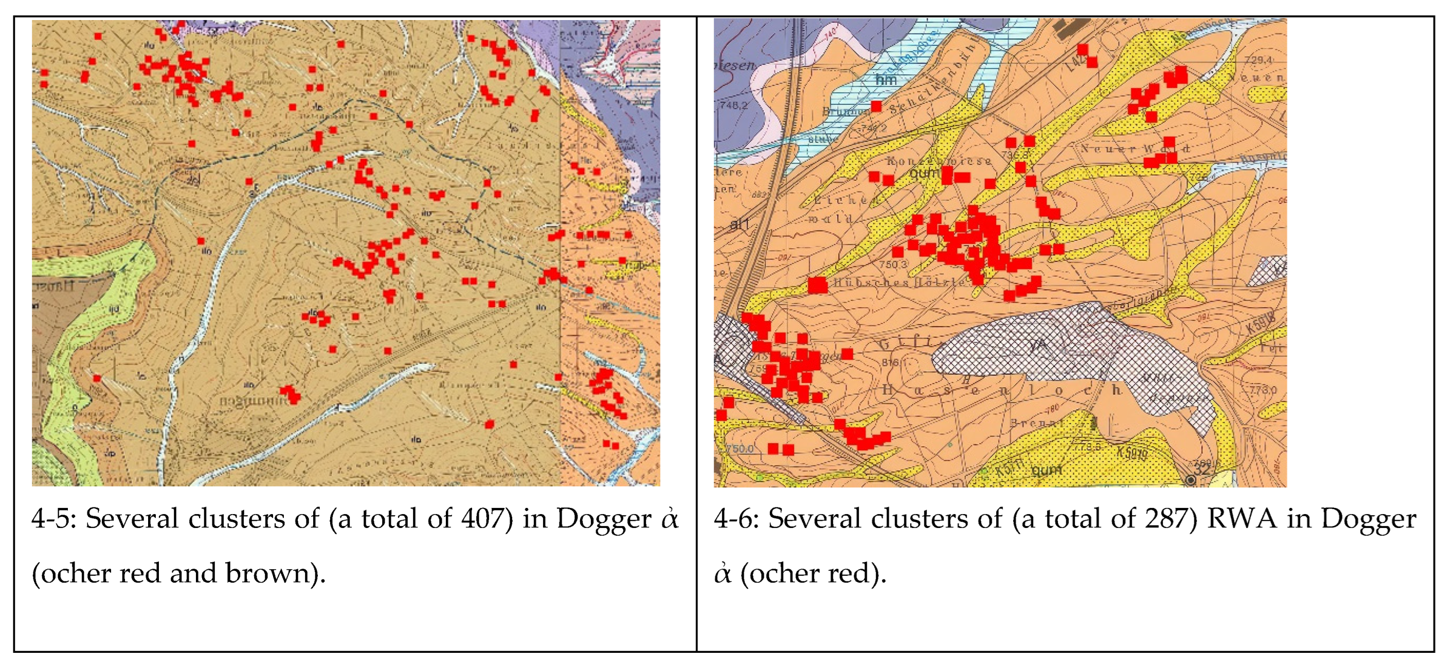
Figure 4.
Geology of RWA sites (Geological Maps: State Geological Survey, Mineral Resources, and Mining Baden-Württemberg: GM 7918 Spaichingen, 1995 [4-1, 4-3, 4-5 east], GM 8018 Tuttlingen, 1997 [4-2, 4-4], GM 7917 Villingen-Schwenningen-East, 2004 [4-5, left part, 4-6]). All maps are from geological maps in scale 1:25.000.
In the areas north and west of Gunningen (GM 7917 Villingen-Schwenningen-Ost, 2004 and GM 7918 Spaichingen, 1995;
Figure 4-5), several clusters of RWA nests were observed, totalling 407 nests, all occupying the strata of the Dogger α (Opalinus shale formation). A similar situation was observed further southwest between Schura and Tuningen (
Figure 4-6) with an accumulation of 287 nests. The Opalinus shale strata are characterized by a sequence of claystones that become sandier and more mica-rich towards the top. These shale strata transition into the approximately 10-meter-thick waterfall beds, where fine-sandy limestone beds up to 30 centimeters thick occur (Franz, Nitsch, 2009). In the adjacent northern and northwest areas, the relief flattens out, and agricultural areas dominate the landscape. This is due to the presence of clayey and marly strata of the Lias (Amaltheenton-Formation, Posidonienschiefer, Jurensismergel-Formation), where, presumably due to the high clay content, no RWA nests were found.
A separate area of interest is located in the northeast (sub-area CE2 in
Figure 1) of the study area (northeast corner of GM 7918 Spaichingen, 1995). In approximately 500 meters wide strips on both sides of the predominantly inferred faults (dotted lines,
Figure 11a, b), more than 100 nests were mapped. Most of these nests are found on the high elevations, primarily formed by massive limestones (sponge-algal limestones) of the Middle Kimmeridge wδ - ζ1 (ki2-til on GM 7918 Spaichingen, 1995;
Figure 11a, b). Only to the west of the fault system and in the lower valley incisions, a few locations were identified on the underlying Oxford limestones [wβ] ox2 (
Figure 11a, b).
Lithologically, the RWA sites can be summarized as follows: The majority of the nests are located in the central and southern parts of the study area (MA) on the forested uplands of the Malm limestone, which exhibit distinct vertical fissuring. When the limestones are overlain by marl layers, no nests are found, except sporadically in transitional zones where the marls are only thinly present due to erosion. In the northern and north-western parts of the study area, the upper Jurassic strata have already been eroded, and mudstone and marl formations dominate. Intercalated harder sandstone or limestone layers in these formations lead to an invigoration of the relief. Geological conditions result in these areas being primarily used for forestry. RWA nests occur on these surfaces, both sporadically and in clusters. In areas where pure claystone formations occur, the relief is slightly undulating and predominantly used for agriculture. In these regions, even forested sections and bushy strips along these agricultural areas are free of RWA nests.
III. 2.2 Mofettes and gases
During the inventory of the RWA sites, numerous mofettes were found, characterized by the emission of CO
2 and a high proportion of methane (
Figure 7b). The gas emission emanation was observed in shallow puddles, released by stirring the subsurface with a stick under the collection funnel. Several liters of gas were liberated within a few minutes, with a continuous inflow of gas from the subsurface being observed. A quantitative determination of gas flux is not feasible, as the areas not covered by water in the vicinity of the water areas cannot be assessed.
IV. Discussion
IV.1 RWA occurrence
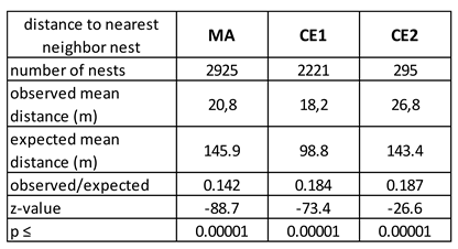
The average distances between RWA nests and their nearest neighbors were found to be smaller than expected, and the foraging distances were also lower than previously reported average values (Wellenstein, 1977), as indicated by the lengths of many RWA trails leading to distant trees (acc. D. Klimetzek). This suggests that the RWA did not reduce the overlap of foraging areas and, consequently, the intraspecific competition, despite some areas having extremely high nest densities.
IV.2. Geology and tectonics
IV.2.1 Field indications of faults
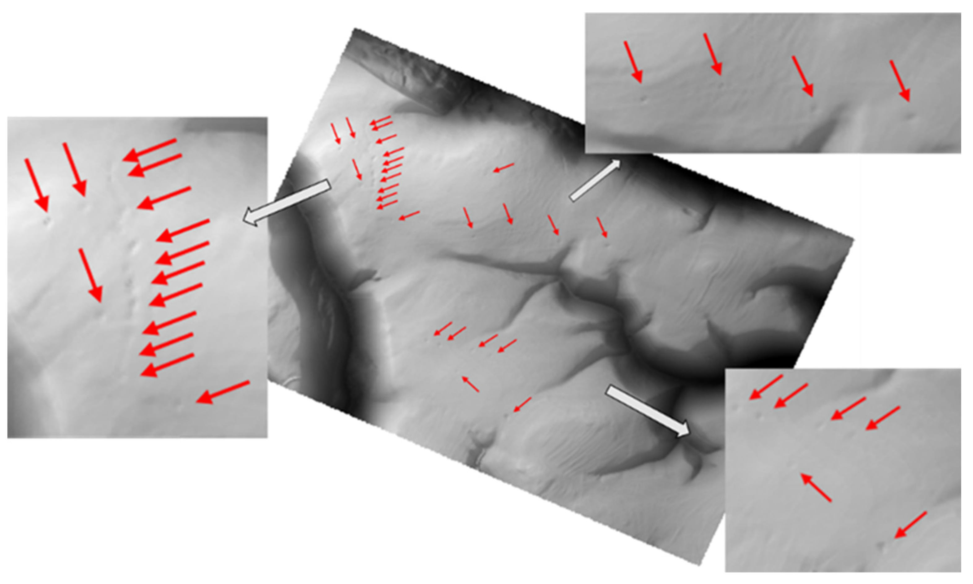
In comparison to areas in the Black Forest or the Eifel, where tectonic faults are exposed at the surface without much overburden, the northern edge of the Swabian Alb exhibits distinct conditions. The tectonic development in the Albstadt shear zone (sup. 2) is relatively young, and as a result, any horizontal or vertical displacements of the Mesozoic strata are not yet evident at the surface due to increased seismic activity ("often invisible for mapping", Geyer, Gwinner, 2011). Additionally, the continuation of the fault planes from the basement rocks to the surface is modified by the plastic behavior of the overlying Mesozoic cover sequence (including gypsum-bearing layers in the Keuper and clay and shale layers in the Jurassic). This results in block rotations and numerous secondary faults, creating a small-scale fracture pattern that is not identifiable at the surface. High-resolution digital terrain models provide insights into recent tectonic activity, allowing for the identification of terrain jumps or doline structures that are not discernible during field surveys in such detail (
Figure 6).
IV.2.2 Digital terrain model
In the digital 1-meter elevation model (
Figure 5), distinctive bead-like doline structures can be observed, running in a north-south or west-northwest/east-southeast direction. The interpretation of these structures as dolines was confirmed in the field. Their formation in this region can be attributed to waters within gas-permeable faults that have a pH below 6 due to the presence of ascending CO
2. The acidic waters dissolve the limestone, creating sinkholes that are linearly aligned along the fault traces. These sinkholes mark the beginning of valley formation, which will progress through ongoing erosion until reaching the level of the watercourses. Some neighboring valleys exhibit the same orientations in their courses, suggesting a similar process for their formation. The fault planes immediately below the dolines are more open due to the dissolution processes compared to other tectonic faults, and their contact with the atmosphere provides good ventilation towards the surface or, in the case of steep slopes, sideways (
Figure 8). Consequently, the release of higher concentrations of CO
2 in the vicinity of the dolines can be expected only when there is a stronger gas influx from depth.
Figure 5.
DGM (Digital Elevation Model) data, along with enlarged sections of the ridge Flachhans/Zepfenacker (map position in
Figure 7 and 2.), highlighting indicators of recent tectonics. The red arrows indicate dolines, which are visible in the field.
Figure 5.
DGM (Digital Elevation Model) data, along with enlarged sections of the ridge Flachhans/Zepfenacker (map position in
Figure 7 and 2.), highlighting indicators of recent tectonics. The red arrows indicate dolines, which are visible in the field.
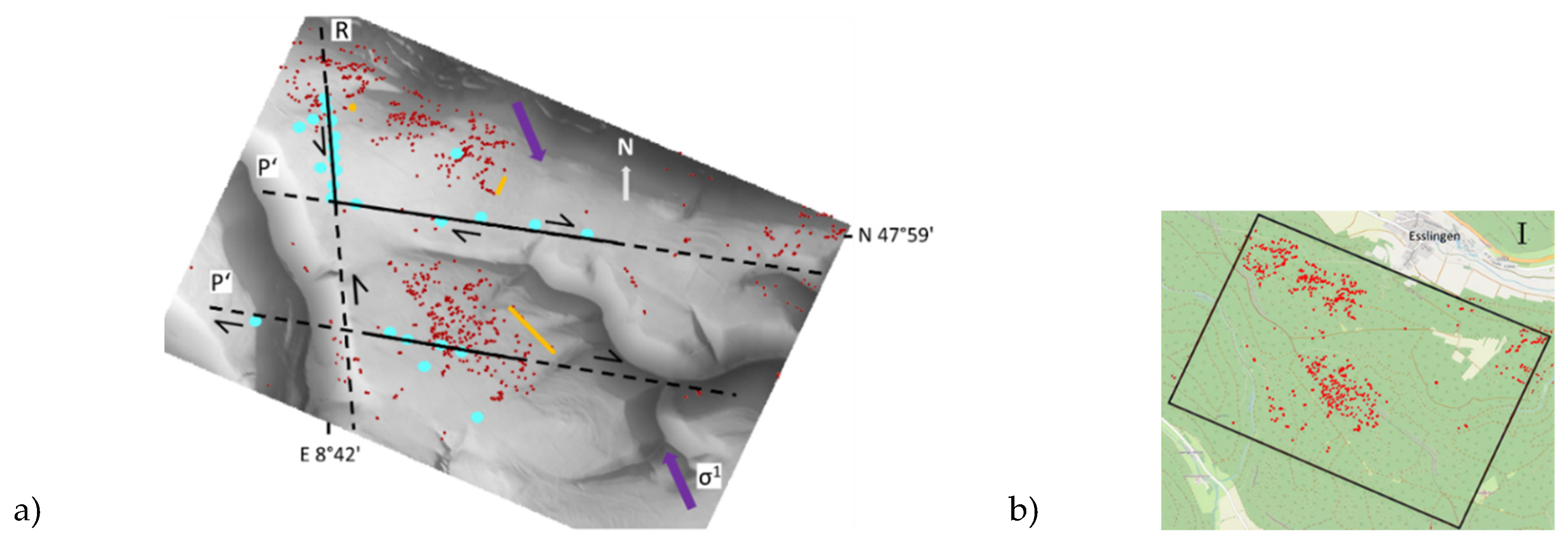
Figure 6.
DGM Data a) Dolines are represented by blue dots; mofettes and iron colloid precipitations are indicated by yellow lines and a yellow dots; faults are shown as solid black lines; extrapolated faults are represented by dashed black lines; σ1 indicates the direction of horizontal main stress; R and P': Riedel shears. RWA sites are marked by red dots. The longer yellow line corresponds to the opening direction, subparallel to the main stress direction. The orientations of the depicted faults represent the Riedel shears R and P' with respect to the main stress direction in the western border area of the Albstadt shear zone (
Figure 7c). b) Geographical location of 6 a) southwest of Esslingen (field I in
Figure 1). Database MagicMap Tour Explorer 25 Deutschland V6.
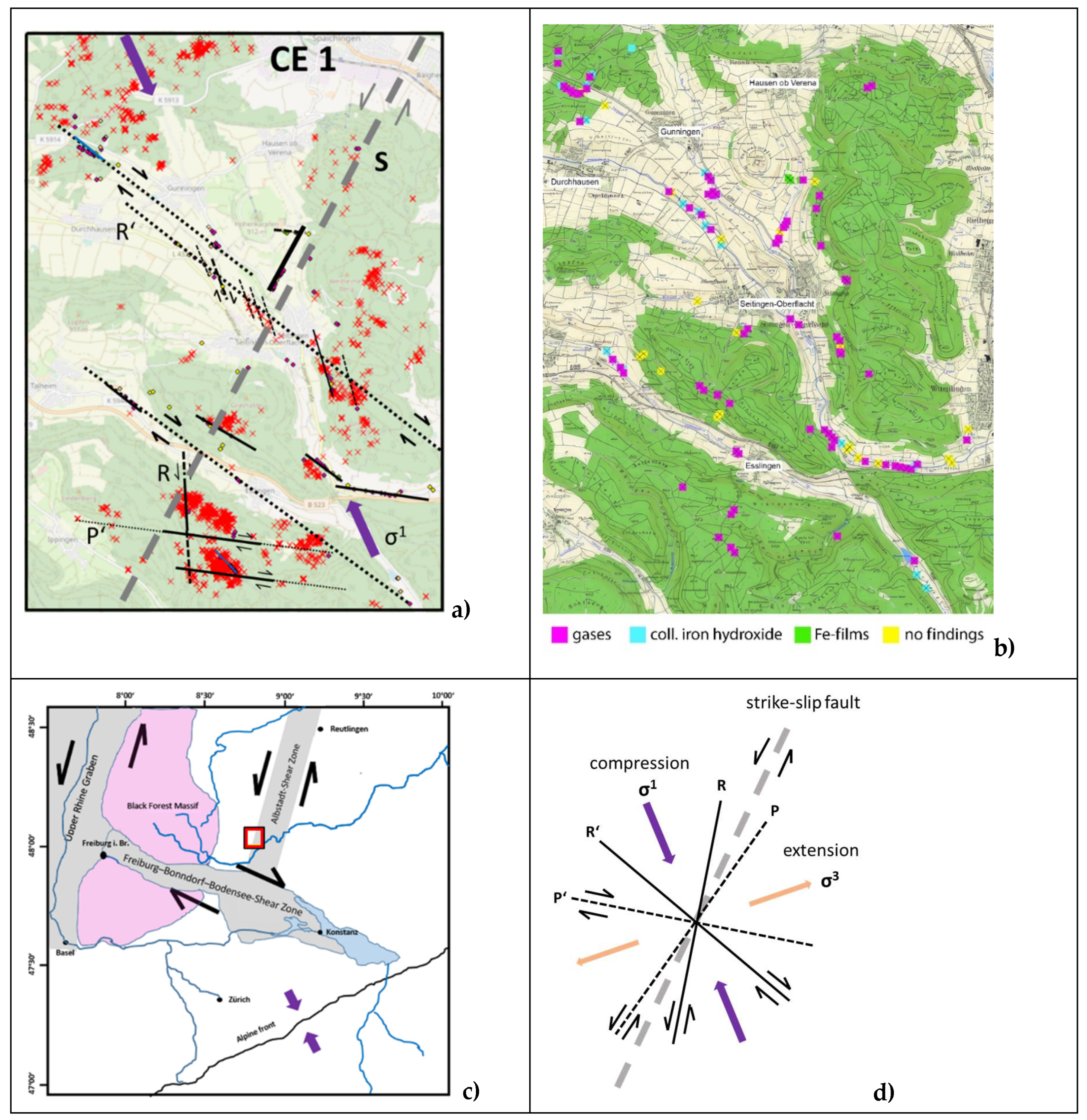
Figure 7a depicts an interpretation of the tectonic conditions in the CE1 area based on the orientation of the horizontal main stress direction (σ1). The interpretation is derived from the distribution of doline features in the southern region, along with mofettes and iron precipitations in streams and standing water bodies. Additionally, prominent rows of RWA nests are shown as evidence of Riedel shears north of Seitingen-Oberflacht (represented by parallel thin dashed lines). Larger, regional strike-slip faults are depicted as presumed (dotted black and grey lines) due to the absence of exposed outcrops of the geological strata. The path and position of the grey dashed NE-SW-oriented strike-slip fault represent the less precisely delineated western area of the Albstadt shear zone (
Figure 7c). The width of this zone is not precisely known. It runs parallel to linearly arranged mofettes (north of Seitingen-Oberflacht) and intersects secondary faults in the southern region. The abundance of faults of different orders, typically developed in an active shear system, cannot be determined due to poor outcrop conditions. Although the existence of gas-bearing fracture zones in the vicinity of RWA occurrences has been widely demonstrated or extrapolated, the precise determination of the orientations of associated faults remains uncertain.
Figure 7.
a) Tectonic interpretation of center subarea CE1 (within the study area MA) based on dolines and CO2-influenced spring waters. Purple arrows σ1: horizontal principal stress direction NW-SE; S: assumed side branch of ASZ (grey line); black lines: strike-slip faults and Riedel shears documented by CO2 sources, solid: confirmed, dashed: suspected. b) Locations of CO2-influenced springs and gas emissions. Database for a) and b): MagicMap Tour Explorer 25 Deutschland V6. c) Illustration of the sinistral shear systems of the Upper Rhine Graben and Albstadt shear zone (ASZ) and the dextral shear zone of the Freiburg-Bonndorf-Bodensee shear zone (FBBSZ) (adapted from: Egli et al., 2017). The red rectangle indicates the location of the study area MA at the northern border of the FBBSZ. d) Schematic diagram of the Riedel shear model, illustrating subsidiary structures that may develop from a sinistral strike-slip shear system (σ1: horizontal main stress direction, R: Riedel shear, P‘- type of Riedel shear).
IV.2.3 Gas behavior in rock layers / Influence of groundwater
The ascent of gases from the deeper crust to the surface is governed by various factors, which require the presence of gas-permeable fault zones and fractures of sufficient size, as well as groundwater in most cases. The CO
2 emitted in the field presumably originates from the mantle (Jost, 2022) and rises through the faults that are kept open by the recent seismic activity in the vicinity of the Albstadt shear zone (Prestel, Schloz, 2011; Zeiß, 2022). If the volumetric flow of CO
2 is sufficiently large, it reaches the surface without being completely dissolved and emerges from dry and moist mofettes. Due to the pronounced relief of steeply protruding ridges in the study area, special conditions must be considered regarding gas emissions. Since CO
2 is heavier than air, groundwater, as a denser medium, must be present for its ascent through sedimentary rocks with an open pore system or fissured limestone. If the distance between the unconfined groundwater level and the surface is too large in relation to the gas flow, the entire pore space of the overlying sediment/rock body cannot be filled. In this case, CO
2 flows laterally along the groundwater surface. After rainfall, it is partially dissolved by percolating water. The remaining gases follow the groundwater surface and emerge above the spring horizon laterally on the slopes (
Figure 8).
Similar conditions exist in narrow mountain ridges and inselbergs that are located north of the Alb. An example is the Hohenkarpfen north of Seitingen-Oberflacht, an inselberg with an elevation of 913 m above sea level (
Figure 8a). Due to the steep relief with a pointed summit, a higher groundwater/fissure water level can be expected only in the central area, but it does not reach the Earth's surface. Towards the edges, the groundwater surface is normally lowered towards the valley until underlying clay-rich sedimentary layers impound the water and direct it to peripheral springs. In the case of Hohenkarpfen, these springs are located in agricultural areas and exhibit typical iron colloidal precipitates (Suppl. 1).
Figure 8.
Importance of groundwater level (GW: blue line) for the ascent of CO
2 and methane in a strike-slip fault overlaid by ridges with steep relief. In areas with low GW level, such as at Hohenkarpfen, the CO
2, which is heavier compared to the pore air, does not reach the surface. It flows laterally along the GW surface and emerges diffusely at the edge (
Figure 8a). In the case of Mittlerer Berg east of Seitingen-Oberflacht, methane, together with CO
2, ascends directly to the top through fractures and pores (
Figure 8b). Plus sign: movement of the block along the fault into the picture, circle with dot: opposite movement of the block towards the observer.
Another situation arises when the ridges, as illustrated by the example of the Mittlerer Berg ridge (with the southern continuation to the Unterer Berg,
Figure 4.1, 4.3, 9.a), have a sufficient width to allow for a higher GW/karst water level (
Figure 8b). In such cases, the ascent of free CO
2 to the surface becomes possible. While no nests occur at the top of Hohenkarpfen, nests are present on the Mittlerer Berg ridge. Even on wider ridges, CO
2 can flow laterally to lower positions and emerge in the vicinity of spring horizons. In forested slopes, RWA nests are frequently found in the immediate vicinity of springs or parallel to the outcrop of water-retaining horizons. Examples of spring outlets with RWA nest sites in the vicinity include the Schafbrunnen west of the Elta stream south of Seitingen-Oberflacht (in CE1), the slope southeast of Seitingen-Oberflacht (
Figure 9a), and the north-south-oriented valley incision northeast of Risiberg (in CE2,
Figure 9b).
Figure 9.
RWA nest sites in lower slope positions in the vicinity of spring outlets (yellow ellipses). a) Schafbrunnen west of the Elta stream and southeast of Seitingen-Oberflacht (field II in Figure1), b) Valley incision northeast of Risiberg (field III in
Figure 1). Database MagicMap Tour Explorer 25 Deutschland V6.
The groundwater conditions in the subsurface of clay-rich cover sediments on the ridges must also be considered in the site discussion. As described above, the Middle Jurassic marls on GM 8018 Tuttlingen, 1997 (Spitz, 1997) and Kimmeridge marls (wγ) ki1 on GM 7918 Spaichingen, 1995 (Berz, 1995), with the exception of some marginal areas, do not host RWA nests (
Figure 5.3, 5.4). On one hand, strong saturation of the upper soil layer quickly seals off pathways for gases from the crust due to swelling or slaking. On the other hand, precipitation poorly infiltrates and runs off the surface. As a result, the underlying fracture and pore volume in the rock layers is not sufficiently replenished to reach a high groundwater level. In this case, infiltration to depth coupled with simultaneous runoff to the steep slopes is more effective than recharge from above.
IV.2.4 Origin of soil gases
The study area is characterized by numerous previously unknown or overlooked gas seepage points from the crust, which were mapped during field surveys. These seepage points are directly connected to deep-seated fault zones and are clear indicators of tectonic disturbances, primarily expressed as strike-slip faults. Visible gas streaming from the bedrock at the bottom of water bodies in the study area demonstrates that the gases originate from the deep subsurface. Isotope analyses of CO
2 confirm that it predominantly originates from the crust/mantle and is not solely produced through surface biological processes. Additionally, at more than 10 locations in streambeds, slopes, and water bodies on ridges, gas emissions with methane concentrations exceeding 80% have been identified (
Figure 7b).
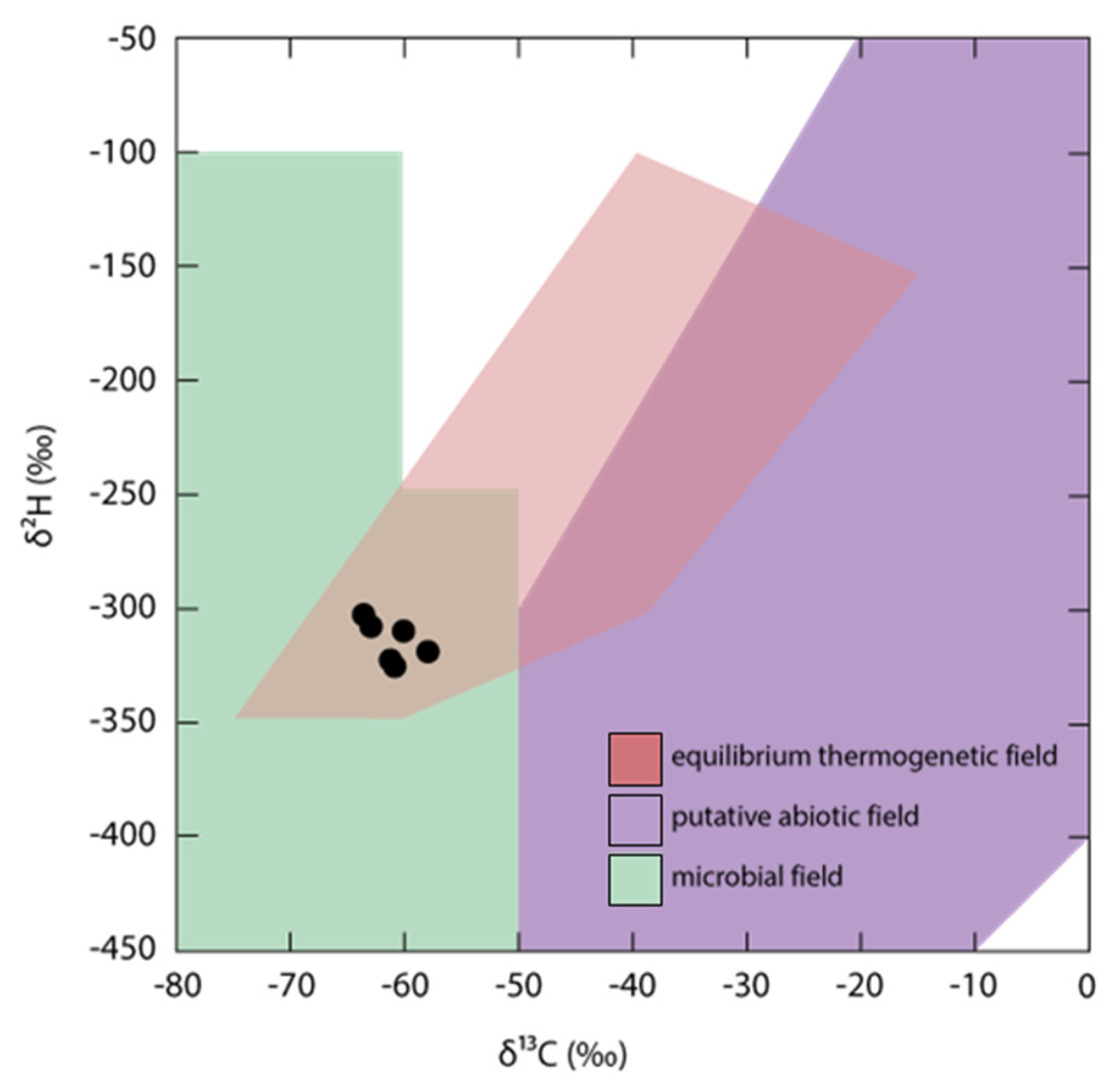
The results of methane isotope determination (δ
13C and δ
2H) do not provide a definitive origin, as their composition falls within the overlap field of microbial and thermogenic sources (
Figure 10). While additional isotope analyses conducted on samples from some of the same as well as other locations suggest a mantle source for CO
2, the results for methane indicate a predominantly biogenic component (Jost, 2022; Kietäväinen, Purkamo, 2015, Suppl. 3). However, the data do not completely rule out a mixture of different sources. Besides the predominantly microbial generation of methane on the surface or in anaerobic deeper areas of the Mesozoic stratigraphy, a thermogenic source should also be considered. The 400 to 500 m deeper lying Posidonia Shale (profiles I and II in GM 7918 Spaichingen, 1995) could be a possible source rock, as it has shown enrichments of hydrocarbons with oil content ranging from 2.4% to 7.8% in individual layers (Berz, 1995). Since the formation of methane from the Posidonia Shale requires temperatures of at least 100 °C over an extended period (Diekmann, 1999), an anomalously high temperature gradient would need to be considered for the study area. A thermal mantle anomaly exists south of Stuttgart, but a possible extension further south is not sufficiently supported (LIAG - Geothermic Information System,
https://www.geotis.de/homepage/ publication#public_relations).
Figure 10.
Diagram of d13C - d2H of methane from six sites near Seitingen-Oberflacht (Suppl. 3). Genetic fields after Milkov, Etiope (2018) and Miller et al. (2018).
Figure 10.
Diagram of d13C - d2H of methane from six sites near Seitingen-Oberflacht (Suppl. 3). Genetic fields after Milkov, Etiope (2018) and Miller et al. (2018).
The portion of methane formed in the crust and ascending in a gas mixture with, for example, CO2, CH4 and N2 must take into account the differences in solubility in groundwater, which can alter the relative composition. While CO2 is relatively soluble at 10 °C (2295 mg/l), the values for methane (29.9 mg/l) and nitrogen (21.6 mg/l) at the same temperature are two orders of magnitude lower. Thus, a stronger lateral groundwater flow, influenced by the solubility differences of gases, contributes to a shift in the gas composition, as demonstrated by N2-mofettes in the Erzgebirge (Weinlich, 2008). This could be a reason why methane is significantly enriched compared to CO2. Additionally, some H2-oxidizing archaea (methanogens) produce methane under anaerobic conditions by reducing CO2 with hydrogen (Enzmann et al., 2018).
IV.2.5 Correlating mapped faults with RWA locations
Only in rare cases do the outcrop conditions in the study area allow a determination of fault trends. Faults are easiest to identify when there are vertical displacements of crustal blocks (normal or reverse faults) that have brought layers of different ages next to each other. However, vertically oriented strike-slip faults, where blocks are horizontally displaced against each other, are difficult to identify due to the absence of significant lithological differences. Yet, these strike-slip faults are the type of faults that provide migration pathways for gases from the mantle and crust, and thus, they play a crucial role in the conditions affecting RWA sites.
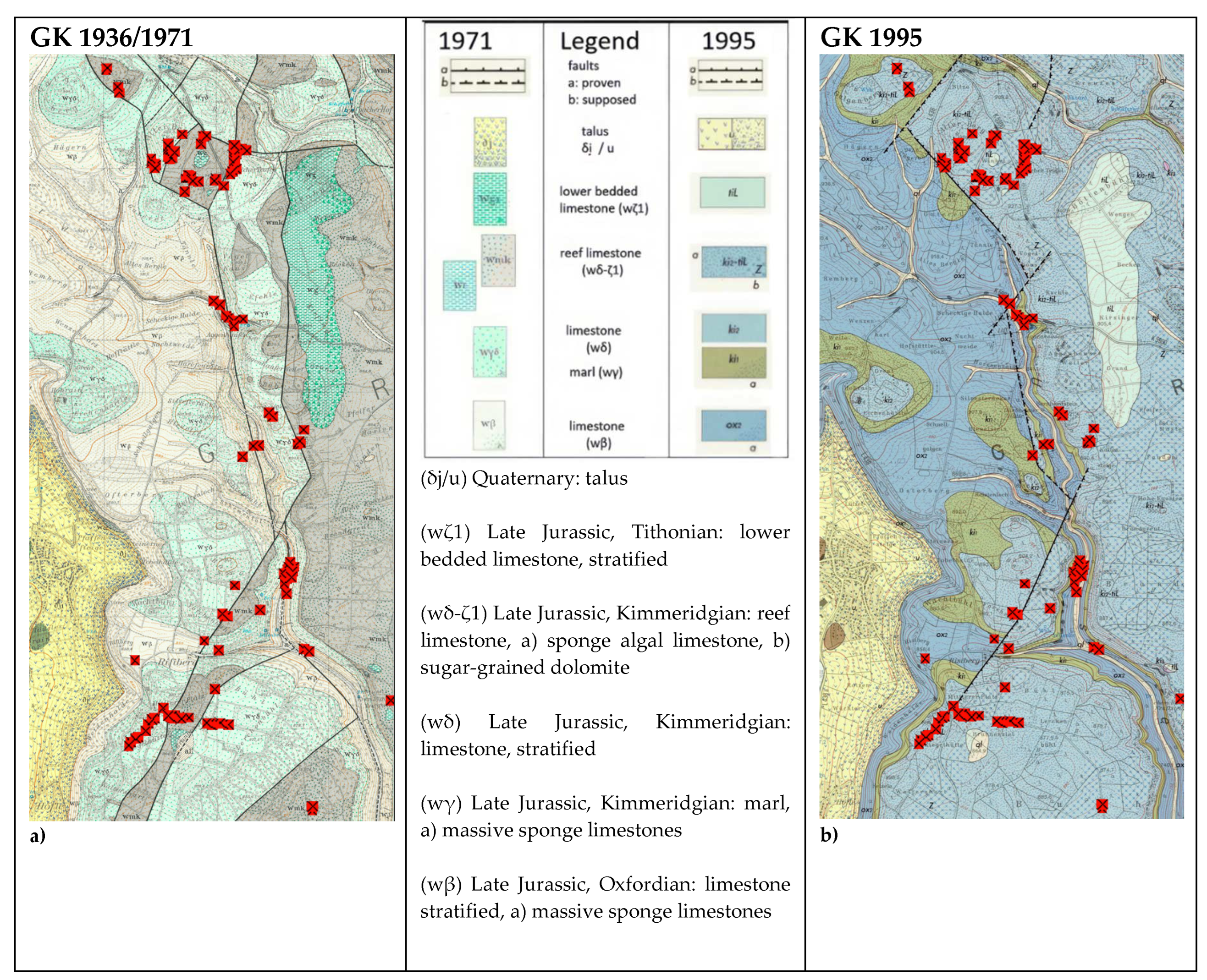
An impressive example of the difficulty in establishing a correlation between RWA sites and published faults in the study area can be found in the easternmost part of the study area (referred to as CE2 in
Figure 1). The geological map for this region was first published in 1936, and an unchanged reissue was released in 1971 (GM 7918 Spaichingen, 1971). In a later revision (3rd edition) of this map sheet, the tectonics in the eastern part (area of the Weißjura plateau; GM 7918 Spaichingen, 1995) were re-interpreted (
Figure 11a).
Figure 11.
a, b: Section CE2 (
Figure 1, 3) from the map sheet GK 7918 Spaichingen (State Geological Survey, Mineral Resources, and Mining Baden-Württemberg) southeast of Dürbheim, showing different observations of mapped faults (black, partially dashed lines) from a) 1936/1971 (GM 7918 Spaichingen, 1971) and b) 1995 (GM 7918 Spaichingen, 1995), along with the locations of RWA nests in 2022 (red squares) in the immediate vicinity of the faults (dashed fault lines: inferred). Smaller parallel displacements, cross faults, and Riedel shears, which always occur in association with strike-slip faults (here overprinted by normal faults), are not captured in the available resolution.
The difficulty in fault mapping is evident from the fact that the majority of faults are depicted as inferred (dashed lines). Additionally, they are interpreted as normal faults, which is possible when vertical displacements of crustal blocks (normal faults, reverse faults) have occurred. However, when these faults are subsequently overprinted by strike-slip movements, the geological relationships become complex and challenging to interpret. Only strike-slip faults that open channels for gas migration vertically are more likely to be colonized by RWA. Therefore, they play a crucial role in understanding the conditions of RWA nesting sites.
Moreover, it is essential to consider that each fault represents the main axis of a whole set of smaller and larger fractures, which are arranged along the principal fault according to tectonic laws. However, due to the lack of outcrops, these subsidiary fractures cannot be mapped. Using the patterns of RWA nest rows, associated faults, running at different angles and distances to the main fault, can be interpreted. This is particularly evident at the southwestern end of the fault according to the 1995 map (
Figure 11b): here, a direct continuation to the southwest is probable. Simultaneously, another row of nests indicates a fault trending in the west-northwest/east-southeast direction, as also recognized from dolines in
Figure 5.
V. Conclusions and outlook
The study area is located in a seismically active region characterized by active shear tectonics. It is predominantly influenced by the north-northeast/south-southwest trending sinistral Albstadt-Bodensee shear zone, whose exact extent can only be relatively roughly determined using focal mechanism solutions after earthquakes in the upper crust. Visible offsets at the surface are often absent due to the small displacement values and the partially plastic-reacting sequence of layers in the Mesozoic cover rocks. Additionally, the area is situated to the north of the conjugate dextral Freiburg-Bonndorf-Bodensee shear zone, which also exerts an influence. The conjugate shear system is dependent on the horizontal principal stress direction of the crust in the northwest-southeast direction. Despite the lack of visible offsets at fault planes, indications of their existence and orientation can be found. These include doline traces and lines of CO2-influenced spring waters, which can be attributed to the stress field of the crust. In many cases, these features can also be associated with tectonic causes for valley incisions.
Gases, including CO2 from the mantle and methane and CO2 from the crust, ascend along the strike-slip faults and related secondary faults. The sources of methane have not been conclusively determined yet, as investigations on microbial methane generation are still pending. Gas discharges along linear paths provide clues to fault orientations. In the case of RWA clusters, these discharges indicate a diffuse passage through the uppermost layers, particularly when a closely spaced fracture network is present. The occurrence of RWA nests follows these gas discharges, resulting in both nest rows and nest aggregations on larger areas. Due to continuous stress changes in the crust, seismic events, dissolution processes, and material displacements, changes in the permeability of fault pathways occur. Therefore, precise geological knowledge is required for interpreting these relationships, and the schematic assignment of mapped faults from geological maps is insufficient for this purpose.
The presence of steep relief in some areas introduces specific complexities that must be considered in interpreting fault orientations and the distribution of RWA nests. The CO2 mofettes can only outgas at the top if the distance of the groundwater table is not too great, preventing the gas from flooding the entire pore space. Otherwise, the CO2 flows laterally.
On the other hand, methane can ascend to the surface even in non-water-saturated pore and fracture space. These hitherto overlooked relationships are directly related to the occurrence of RWA nests.
Overall, the investigations have shown that the distribution of RWA nests does not strictly adhere to uniform ecological conditions. Specific forest types, tree species, soil types, or lithological substrates are not consistently required. Instead, the connection to gas discharge locations appears to be a general prerequisite for the aggregation and long-term existence of the population. However, equating this solely with the presence of gas-permeable faults can lead to misinterpretations, as demonstrated by the occurrence of hang-parallel gas discharges above water-retaining layers. It has become evident that a comprehensive understanding of geological, hydrogeological, and morphological relationships is essential before a direct association between the occurrence of RWA nests and tectonic faults can be regarded as certain.
The question of the cause for the conspicuous occurrence of RWA nests in connection with gas-bearing fault zones remains. Long-term investigations have revealed that CO2 is a crucial factor in this regard. Therefore, it must provide a significant advantage to the site, likely attributed to multiple factors. Perhaps the reduced oxidation of accumulated plant mass due to an increased CO2 concentration in the nest might play a decisive role. As observed in cases of spontaneous combustion of hay, under specific conditions, moist organic material can experience a significant temperature rise through oxidation and the influence of bacteria (Rothbaum, 1963). A decrease in the oxygen concentration in the nest caused by CO2 or even methane would counteract this process. Furthermore, interactions with other soil organisms must be given greater consideration. Phytophagous insect larvae and plant-parasitic nematodes exhibit a positive response to CO2. Additionally, the saprophagous collembolan species Sinella coeca, as well as other collembolan species, aggregate around CO2 sources. Methane induces similar effects, albeit weaker than those caused by carbon dioxide (Klingler, 1975). This aspect should be taken into account concerning the ant queen's nutritional situation, especially during nest establishment. In essence, it can be concluded that the frequent occurrence of RWA represents an initial step in detecting gas emissions, the quantification of which may be particularly significant in the context of methane outgassing.
Supplementary Materials
The following supporting information can be downloaded at the website of this paper posted on Preprints.org.
Funding
This research received no external funding
Acknowledgments
We would like to thank Frank Keppler (Institute of Earth Sciences, Heidelberg University) and Alexander Probst (Faculty of Chemistry, University of Duisburg-Essen) for fruitful discussions. Our sincere thanks goes to Petra Maresch for her invaluable contributions and support to our work. A big thanks to Andrei Machikhin for his support with the maps.
Conflicts of Interest
The authors declare no conflicts of interest.
References
- Berberich, G., Schreiber, U. (2013). GeoBioScience: Red wood ants as bioindicators for active tectonic fault systems in the West Eifel (Germany). Animals, 3(2), 475-498. [CrossRef]
- Berz, K. C. (1971). Erläuterungen zur Geol. Karte Baden-Württ. 1:25.000, 7918 Spaichingen, 135 pp., Stuttgart. [unaltered reprint of the first edition from 1936].
- Berz, K. C. (1995). Erläuterungen zur Geol. Karte Baden-Württ. 1:25.000, 7918 Spaichingen, 3. revised edition, 193 S. Freiburg i.Br.
- Del Toro, I., Berberich, G. M., Ribbons, R. R., Berberich, M. B., Sanders, N. J., Ellison, A. M. (2017). Nests of red wood ants (Formica rufa-group) are positively associated with tectonic faults: A double-blind test. PeerJ, 5, e3903. [CrossRef]
- Dieckmann, V. (1999). Zur Vorhersage der Erdöl-und Erdgaszusammensetzung durch die Integration von Labor-und Fallstudien (No. PreJuSER-39888). Erdöl und Geochemie.
- Enzmann, F., Mayer, F., Rother, M., Holtmann, D. (2018). Methanogens: biochemical background and biotechnological applications. Amb Express, 8, 1-22. [CrossRef]
- Franz, M., Münzing, K. (2004) Erläuterungen zur Geologischen Karte Baden-Württemberg 1:25000, 7917 Villingen-Schwenningen-Ost. 6. completely revised edition, 199 pp. Freiburg i. Br.
- Franz, M., E. Nitsch (2009): Zur lithostratigraphischen Gliederung des Aalenium in Baden-Württemberg. LGRB-Informationen, 22: 123–146.
- Geyer, O. F., Gwinner, M. P., Geyer, M., Nitsch, E., Simon, T. (2011). Geologie von Baden-Württemberg, Stuttgart, Schweizerbart.
- Grathoff, G. H., Baham, J. E., Easterly, H. R., Gassman, P., Hugo, R. C. (2007). Mixed-valent Fe films (‘schwimmeisen’) on the surface of reduced ephemeral pools. Clays and Clay Minerals, 55, 635-643. [CrossRef]
- 11. Jost.
- Kleja, D. B., van Schaik, J. W., Persson, I., Gustafsson, J. P. (2012). Characterization of iron in floating surface films of some natural waters using EXAFS. Chemical Geology, 326, 19-26. [CrossRef]
- Kietäväinen, R., Purkamo, L. (2015). The origin, source, and cycling of methane in deep crystalline rock biosphere. Frontiers in microbiology, 6, 725. [CrossRef]
- Klingler, J. (1975): Beobachtungen zur Reaktion bodenbewohnender Tiere auf einige biologisch wirksame Gase. Mitt. Schweiz. Entomol. Ges., 48, 99-106.
- Milkov, A. V., Etiope, G. (2018). Revised genetic diagrams for natural gases based on a global dataset of> 20,000 samples. Organic geochemistry, 125, 109-120. [CrossRef]
- Miller, H. M., Chaudhry, N., Conrad, M. E., Bill, M., Kopf, S. H., Templeton, A. S. (2018). Large carbon isotope variability during methanogenesis under alkaline conditions. Geochimica et Cosmochimica Acta, 237, 18-31. [CrossRef]
- Nicolai, B. (2018). Nahrung und Nahrungsökologie beim Hausrotschwanz Phoenicurus ochruros–eine Übersicht. Vogelwelt, 138, 143-175.
- Nierhaus-Wunderwald, D. (1995). Forest ants and their role in the dispersal of seeds and fruit. agris.fao.org.
- Prestel, R., Schloz, W. (2011). Aufstiege von tiefem Kohlendioxid (CO2) durch die Opalinuston-Formation in Baden-Württemberg. Jahreshefte der Gesellschaft für Naturkunde in Württemberg, 167, 163-190.
- Reisch, J. (2013). Waldschutz und Umwelt. Springer.
- Rothbaum, H. P. (1963). Spontaneous combustion of hay. Journal of Applied Chemistry, 13(7), 291-302. [CrossRef]
- Schreiber, U., Brennholt, N., Simon, J. (2009). Gas permeable deep reaching fracture zones encourage site selection of ants. Ecological Indicators, 9(3), 508-517. [CrossRef]
- Seifert, B. (2007). Die Ameisen mittel-und Nordeuropas (pp. 204-320). Tauer: lutra Verlags-und Vertriebsgesellschaft.
- Seifert, B. (2008). Removal of allometric variance improves species separation in multi-character discriminant functions when species are strongly allometric and exposes diagnostic characters. Myrmecological News, 11, 91-105.
- Seifert, B. (2018). The ants of central and north Europe. lutra Verlags-und Vertriebsgesellschaft.
- Spitz, W. (1997): Erläuterungen zur Geol. Karte Baden-Württ. 1:25000, 8018 Tuttlingen, 3. unaltered edition., 107 pp. Freiburg i.Br.
- Vandegehuchte, M. L., Wermelinger, B., Fraefel, M., Baltensweiler, A., Düggelin, C., Brändli, U. B., … Risch, A. C. (2017). Distribution and habitat requirements of red wood ants in Switzerland: Implications for conservation. Biological Conservation, 212, 366-375. [CrossRef]
- Weinlich, F.H. (2008). Die Stickstoff- und Methangase des sächsischen Erzgebirges und seiner angrenzenden Gebiete. Geochemie und Genese, ZDGG, 159, 2, 317-329.
- Wellenstein, G. (1977). Hinweise für die Benutzung der Bienenwanderkarte (Ameisen Atlas) und die Aufstellung von Bienen im Wald. Biene.
- Wellenstein, G. (1990). Waldbewohnende Ameisen: ihre Bedeutung, ihre Biologie, ihre Hege und ihr Schutz. Allg. Zeitungsverlag.
- Zeiß, J., Stange, S., Brüstle, A. (2022). Regional model of peak ground motion in Southwestern Germany. Journal of Seismology, 26(6), 1105-1136. [CrossRef]
|
Disclaimer/Publisher’s Note: The statements, opinions and data contained in all publications are solely those of the individual author(s) and contributor(s) and not of MDPI and/or the editor(s). MDPI and/or the editor(s) disclaim responsibility for any injury to people or property resulting from any ideas, methods, instructions or products referred to in the content. |
© 2023 by the authors. Licensee MDPI, Basel, Switzerland. This article is an open access article distributed under the terms and conditions of the Creative Commons Attribution (CC BY) license (http://creativecommons.org/licenses/by/4.0/).
