Submitted:
17 December 2023
Posted:
18 December 2023
Read the latest preprint version here
Abstract
Due to urban sprawls, the arable land is shifting in the settlement areas and towns, while industrial development is making it more vulnerable. The current study was conducted to see the changes in land use and land cover in Kotri area, Pakistan from 1998 to 2020 to establish trends in recent land use development based on available land use data. In this regard, satellite images in the study area were acquired from USGS and processed using ArcMap 10.5 and Environmental for Visualizing Images (ENVI). Results show that; there was a change in the settlement pattern of Kotri city with 40% between 1998 and 2020, 77% decrease in Bare-land was observed in 2020. Natural vegetation in the study area has decreased significantly with 4.4 Sq/ km in 2020, surface water-bodies in 1998 were 1.3 sq/km and in 2020 there is 1.8 Sq/km indicating 32% increase in surface water bodies. It was further revealed that settlement in Kotri has increased due to its geographical location, nearness of the major city of Hyderabad, and the establishment of the industrial zone and educational city near Kotri. From the foregoing, the study concluded that Kotri City will have more changes in its land use and land cover as the expansion in the city is going on and on. It is therefore recommended that local government and provincial government should pay attention towards this development and put up an action plan towards proper provision for such expansion.
Keywords:
Land use
; Land Cover
; Change
; Kotri Jamshoro
; Settlement
Introduction
Rapid growth in population and industrial development has caused urban sprawl around the world which has infringed on agricultural land, essential forest land and environmental conditions globally. Land use and land cover change in an area is the outcome of natural and socio-economic aspects and their operation by a human in time and space. Land use land cover (LULC) changes are mostly influenced by the increase and decrease in population growth (Lambin et al., 2003), economic growth, and physical factors such as topography, soil type, and climate (Setegn et al., 2009). Among those, population growth and industrial development are the most important factors playing their role in its change and have negative impacts on the environmental conditions of the region. It has been reported by several authors that settlement patterns are rapidly changing in developing countries mostly in Asia and Africa with greater extant (Zhang et al., 2013). This change was speedier globally in the twentieth century where the population shifted from rural to urban areas for better living standards and facilities; due to that the cities in the developing world have gone through a massive increase in the population. Looking on the rate of urban growth, United Nation has predicted that by 2025 around five billion people (61% of total population), will be living in cities. According to the reports and published literature it is said that the twentieth century was a period of unprecedented demographic change. The global population increased nearly fourfold, growing from 1.6 billion in 1900 to 6 billion in 2000 (Cohen 1995); this caused urban sprawls and led to serious issues because of that the productive agricultural land, forest land and surface water bodies have decreased and are further decreasing (Uma and Mahalingam, 2011). Urban growth in the South and East Asian countries has distorted dissimilarity between urban and rural areas (Cohen, 2004; DeFries et al., 2010). Seven of the 10 most 2 populous cities of the world are in the Asia Pacific region, i.e., Tokyo, Delhi, Shanghai, Mumbai, Beijing, Dhaka and Kolkata (United Nations ESCAP 2013). It is said that due to urbanization in Southeast Asian countries, land use and land cover are changing largely and are attributed to industrialization and globalization (Mahadevia, 2008; Newman and Thornley, 2000).
The population of Pakistan was about 33 million at the time of its Independence in 1947, it increased to 43 million in 1961, it was 84 million in 1981, 131 million in 1998 and in 2017 it reached to 207.8 million (Basit, et.al. 2018). The population growth rate in Pakistan is 2.40% which is the highest rate in South Asia. According the reports of UNDP Pakistan (2019) Pakistans urban population increased from 6.9 million (18%) in 1950 after independence, to 45.3 million (34%) in 1993 after 1950 (Akhter, S. & Dhanani, M.R.2013). Sindh is a most urbanized province of Pakistan, approximately 35% population of Sindh lives in Karachi; Hyderabad and Sukkur along with that other cities of the provinces such as Karachi, Hyderabad, Larkana, Dadu, Mirpurkhas, Sukkur are also growing constantly. Mega flood 2010 has added more growth in those cities as the major population in the province was displaced; historical floods i.e., 1948, 1961, 1972, 1994, and 2003 also increased population in those cities (Basiht, 2001).
Kotri city sheltered many families during 2010 floods; most of these families who came for shelter have settled here after the flood. Kotri has been major city of attraction to the peoples of Pakistan as it has the most pleasant weather and has industrial zone. Beside that, Noriabad industrial zone and Hyderabad industrial zone are also near to this city which are providing job opportunities and support to the large number of population. Since land cover and land use changes are attributed to the urban expansion, the growth in population and industrial development along with other activities are expediting it. Therefore, it is imperative to understand and evaluate the rate of land use and land cover change to standardize urban areas and regulate its further expansion. Proper information on land use and land cover of study area will help in the selection, planning and of urban 3 development and making further plans to meet the demands of its inhabitants. The acquired information on its causes of expansion can assist us in monitoring the dynamics of land use resulting out of the changing demands of the inhabitants (Zubair, 2006). Since Kotri is also facing rapid expansion therefore this study assesses the land use and land cover changes in Kotri are from 1998 to 2020 with the help of Remote Sensing and GIS techniques.
Materials and Methods
Study Area
Kotri city is located on the right bank of the Indus River; it is 29th largest city in Pakistan and is a largest city of Jamshoro district. Geographically Kotri city is located on 25.373964° North latitude and 68.301315°East longitude (Figure 1), according to the Census report of 1998 its population was 62,085 whereas it reached 259,358 in 2017 and is considered as an immense increase of 317.75% in just 19 years. The Kotri is a dynamic city with heavy industry which can be characterized as a rapidly developing city of the province. It has an industrial zone located by the city which is spread on around 1875 Acres. This zone was established up on 21 Jan 1973. At Present Kotri is the Second greatest Industrial Area in the Province (Kotri Association of Trade and Industry, 2019). Kotri Site area is the focal point of employment for the population of Jamshoro district and its adjoining areas (Makhdoom, 2018). Kotri has pleasant weather and is famous for its summer breeze; it is 22m high above sea level. Climatically Kotri falls in BWh group of a climate according to Köppen and Geiger climate classifications. Kotri has very little annual rainfall (170 mm). The average annual temperature of the area is 27.7 °C.
Methods
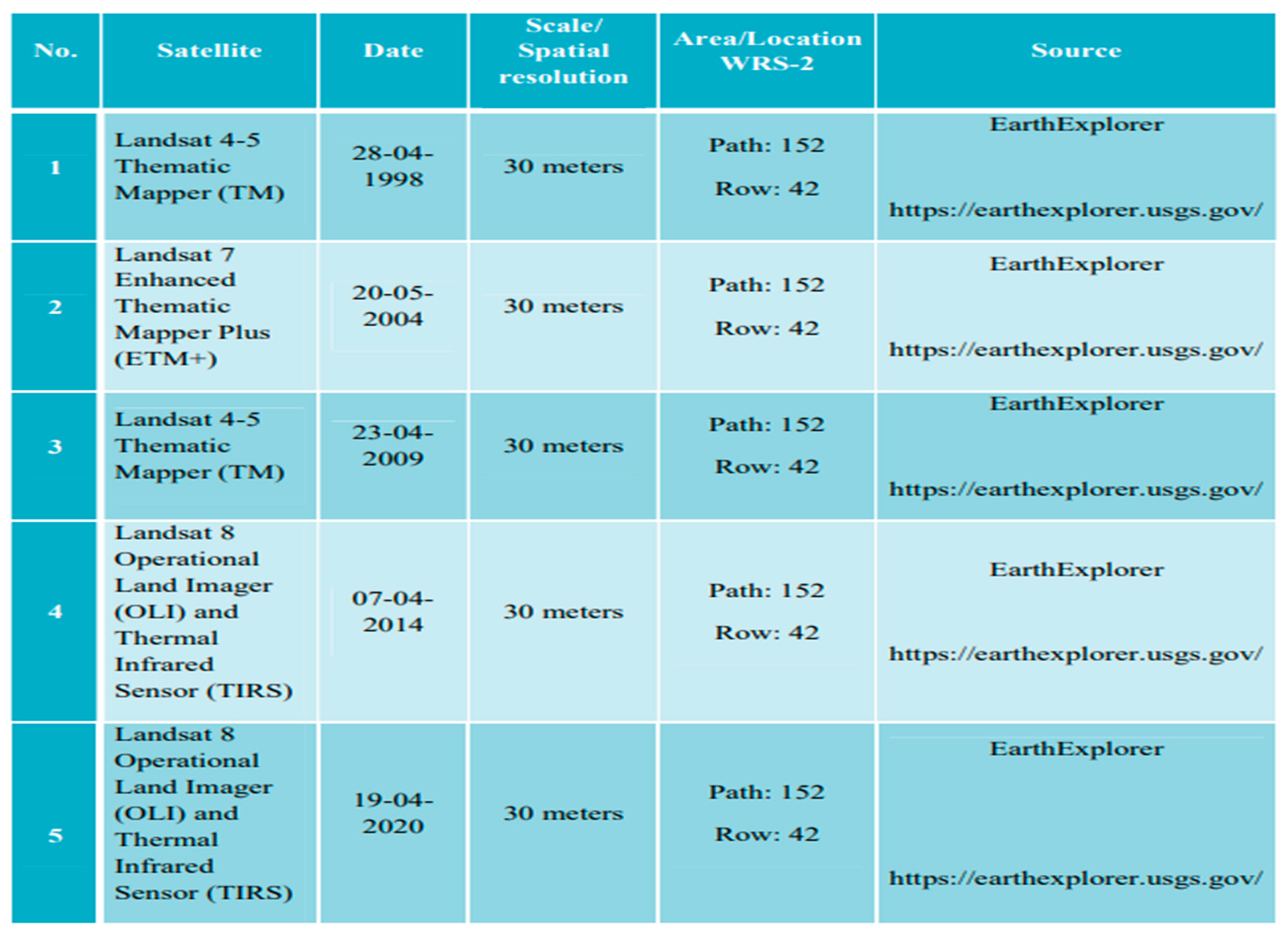
This study assesses spatial and temporal changes in land use and land cover in Kotri area from 1998 to 2020. In this regard (05) Landsat images 1 Level-1 for the years 1998, 2004, 2009, 2014, and 2020 were acquired from the United States Geological Survey (USGS). Images were collected with (WRS-2) path 152 and row 42 with a resolution of 30 meters/pixel. ArcMap 10.5 was used for geo-referencing in environment for visualizing images (ENVI).
The Image of Landsat were added into ArcMap Landsat Image are Multispectral each image came with one single bands that can be displayed on the gray scale colors, to composing the bands into one single image we use ArcMap tool image analysis where seven bands were selected from 1-7 to composite into one image then it can be displayed with color through RGB.
The data of Landsat came with pre-processed corrected and georeferenced from earthexplore.usgs.gov with format of (geotiff) which can store coordinates. However, verifying the data samples of coordinates which were collected during the field work are used to verify georeferenced with help of high resolution image of Google Earth.
A shape-file is a simple, no-topological format for storing the geometric location and attribute information of geographic features. Geographic features in a shape file were represented by points, lines, and polygons (areas). The shape-file was created to form boundary of area and extraction, the process of creating shape-file. The Google earth has high resolution image which was used to cover area with polygons added in Google earth then saved it into (kml format), then the kml format was converted into layers in ArcMap by using ArcMaps conversion tools (from kml to layers), then the layer data were exported into shape-file. The image of Landsat comes with large size of area to minimizing the area to closely study the area the extract by mask in ArcMap tools were used to for extraction of the area by 12 adding shape-file which create boundary of the area then the outside of the area was removed by ArcMap tool
The Landsat image acquires multispectral which divides the electromagnetic spectrum into many different bands. In the study every band were tested to analyze and to distinguish between water, settlement, vegetation and bare land, finally the Natural Color Composition and False Color Composition were used. The natural color composition was used to understand the study area and was compared with high resolution images of google earth. The false color composition was used to separate vegetation from land use.
Image classification is the process of assigning a pixel into different classes of land use land cover to make sets of features in maps, there are two commonly used process of classification are supervised and unsupervised, Unsupervised classification is software base analysis where common pixel are characterized into classes while supervised classification is training base human analysis, where groups of pixel taken as a training samples from ground truth point, Arial imagery, high resolution imagery, and human interpretation to choose few sets of training samples then the software will apply this into whole image and to categorize into different classes, the most common algorithm is used in the supervise classification are maximum likelihood and minimum-distance classification. In the study land use land cover map was classified into four classes Settlement, bare land, vegetation, and water. By assigning training samples in the different classes, the algorithm set maximum likelihood in the supervise classification.
In the post-classification the Majority filter used to bind the scattered pixels, boundary cleaning was used to remove noise pixels and few single pixels were also removed through converting raster to points and using by grid code. The statistical data measured on the raster image which has size of each cell have 30 square meter, the count of cell were stored in the attribute table which is used in graphical data (Figure 2).
Results and Discussion
Landsat Data of Kotri city
Based on the prior knowledge of the study area a brief reconnaissance survey with the additional information from previous research related to the area was conducted. A classification scheme was developed for this purpose which included built-up area, vegetative cover, barren land, and water bodies. The classification scheme developed in this study gives a broad classification where land cover land use was identified by a single digit. By built-up area, we mean all the buildings, roads and sealed surfaces found in the study. The definition of vegetation as used in this research denotes to all trees, all season crops in the area, bushes, grasses as well as aquatic vegetation found in the study area.
Similarly all the vacant areas, abandoned fields, patches of bare soils have been designated as open areas. River, water channels and all the swampy areas have been classified as water bodies. Finally, during classification all objects with spectral resolution less than 30 meters were treated as mixed class. After that, usual procedures used in land use and land cover changes have been adopted in a systematic manner. Land use and land cover changes are visible all over the study area. The calculation of the area is presented in kilometers and the five land use and land cover types for each study period were identified. Finally, we compared the results obtained through the spatial matrix in ENVI imagine.
Table 4 presents the data collected from Landsats. Kotri city is facing rapid expansion in its settlement; the obtained and analyzed images reveals that from 1988 and 2020 different areas of the city are expanding where settlements is replacing natural habitats; the scale of this change was high from 2004 to 2016. Comparing to Kotri with other areas of Jamshoro, it can be seen that this area has a high rate of expansion and is still increasing more rapidly than that of its surroundings towns.

Table 4.
Data and the sources of its collection.
Land Use and Land Cover in Kotri
The land of Kotri is classified into four classes; the obtained data of Land use and Land cover distribution is gathered from each map and is discussed below (Figure 3). Settlement pattern in the study area covered 46.9% of the total land in 1998 which expanded to 65.9% in 2020. The barren land has decreased to 14.3% in 2020 which was 32% in 1998. Vegetation was 16.7% of the total studied land in 1998 which increased 19% in 2004 and again decreased in 2020 and reached to 13.8% Water body has also increased, in 1998 water was 4.2% of the total studied land which increased to 5.7% in 2020. The percentage of increased water is due to the municipal water disposal ponds near the study area. The obtained data for 1998 shows that Kotri city covered 46.9% of total land (15.2019 Sq/ Km), Bare-land 32% (10.4004 Sq/ Km), Vegetation 16.7% (5.4432 Sq/ Km) and water bodies covered 4.2% (1.3653 sq. km).
Settlement Changes In Kotri Area From 1998 To 2020
The obtained data shows that the area under settlement/township was 15.2019 Sq/Km and 1.1439 Sq/Km increased in it is seen 2004 (16.3458Sq/Km) and it reached 18.0963 Sq/Km in 2014and in 2020 it has reached to 21.3813 Sq/ Km (Figure 4).
The most interesting point here is that the area under settlement has increased rapidly after 2010. The R2 vale of polynomial regression is 0.97 of the data for all the studied years (Figure 3). This was also confirmed in a field survey to compare the obtained data from satellite images. The interviews were taken with the old residents of Kotri who also said that the settlement has increased in this area rapidly after the mega floods in 2010. Since the weather in this part of the province is pleasant.
Moreover, the rate of residential Plots around the city is cheaper as compared to other surrounding areas which have attracted peoples to come and settle in this part. The nearness of industrial zones and major universities is another cause of this rapid increase in this part of Kotri (Figure 5).
Barren land changes in Kotri area from 1998 to 2020
The barren land change in Kotri is assessed from 1998 to 2020. The obtained data reveals that it was 10.4004 Sq/Km of total studied land in 1998 and surprisingly, it is decreasing constantly and has reached to 4.66 Sq/Km in 2020. The R2 value of liner regression model is 0.99 of the data of all the studied years (Figure 6 and Figure 7).
Vegetation changes in Kotri area from 1998 to 2020
The obtained data for the assessment of vegetation change in different years is presented graphically in Figure 8 and is given in Table 5. The obtained data reveals that the vegetation in the Kotri area has also decreased with the passage of time. It was 5.4432 Sq/Km in 1998, 6.1371 Sq/Km in 2009, 4.6188 Sq/Km in 2014, and 4.4856 Sq/Km in 2020. Here it is interesting to see that in 1998 and 2009 it increased to some extend, however, it has again decreased and has reached to 4.4865 Sq/Km in 2020 (Figure 8, Table 5). The R2 vale of polynomial regression model is 0.71 of the data of all the studied years (Figure 7 and Figure 8).
Surface water changes in Kotri area from 1998 to 2020
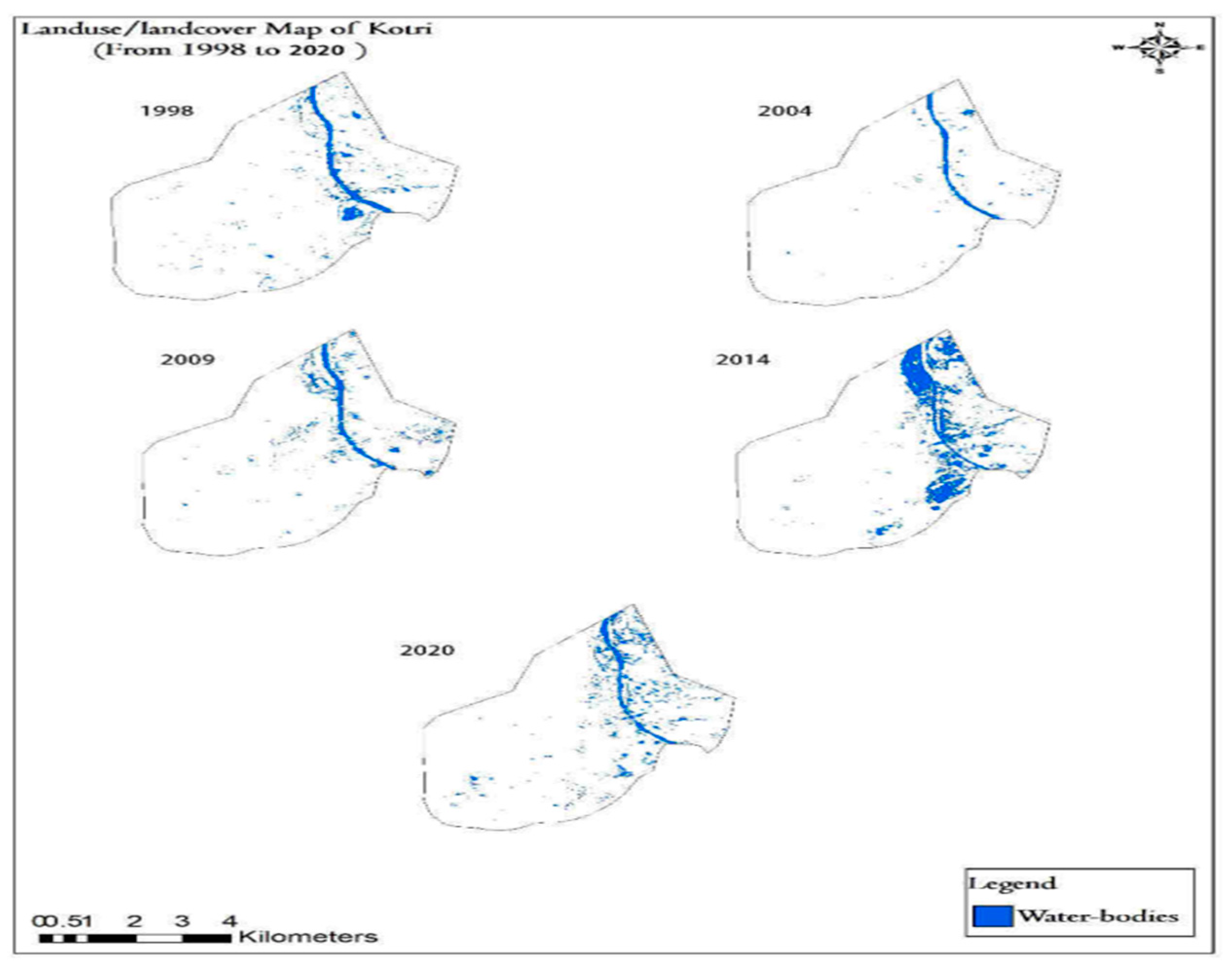
The obtained data for surface water changes assessment in the study area is given in Table 10 and is also presented graphically in Figure 8. The obtained data reveals that the area under the surface water body is fluctuating in Kotri with the passage of years.
It was 1.3653 Sq/Km in 1998, 0.6786 Sq/Km in 2004, 1.395 Sq/Km in 2009, 3.6188 Sq/Km in 2014 and 1.8792 in 2020 (Figure 9).
Figure 9.
Vegetation cover changes in Kotri from 1998 to 2020.
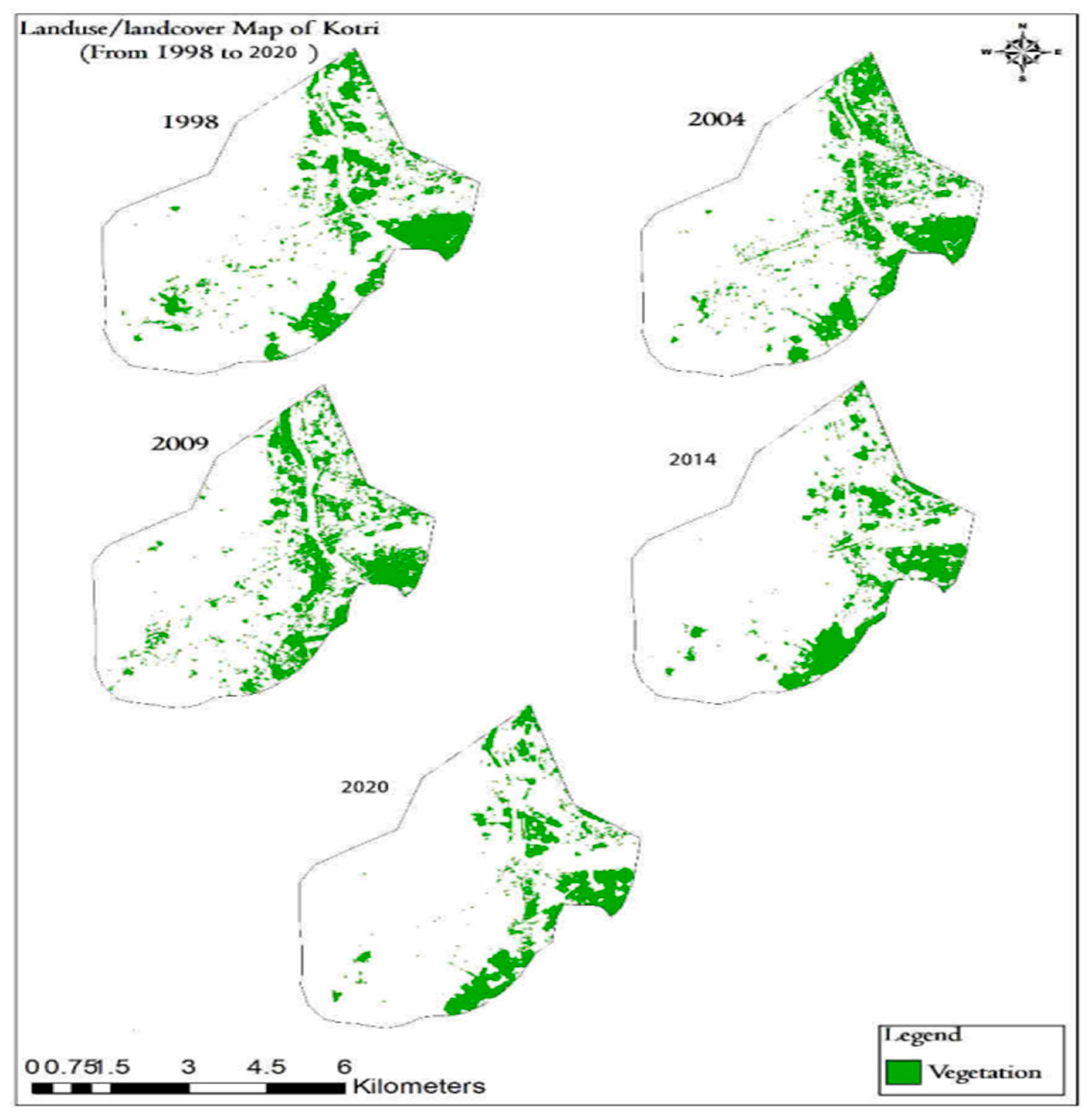
Figure 10.
A graphical representations of water- bodies changes in study area from 1998 to 2020.
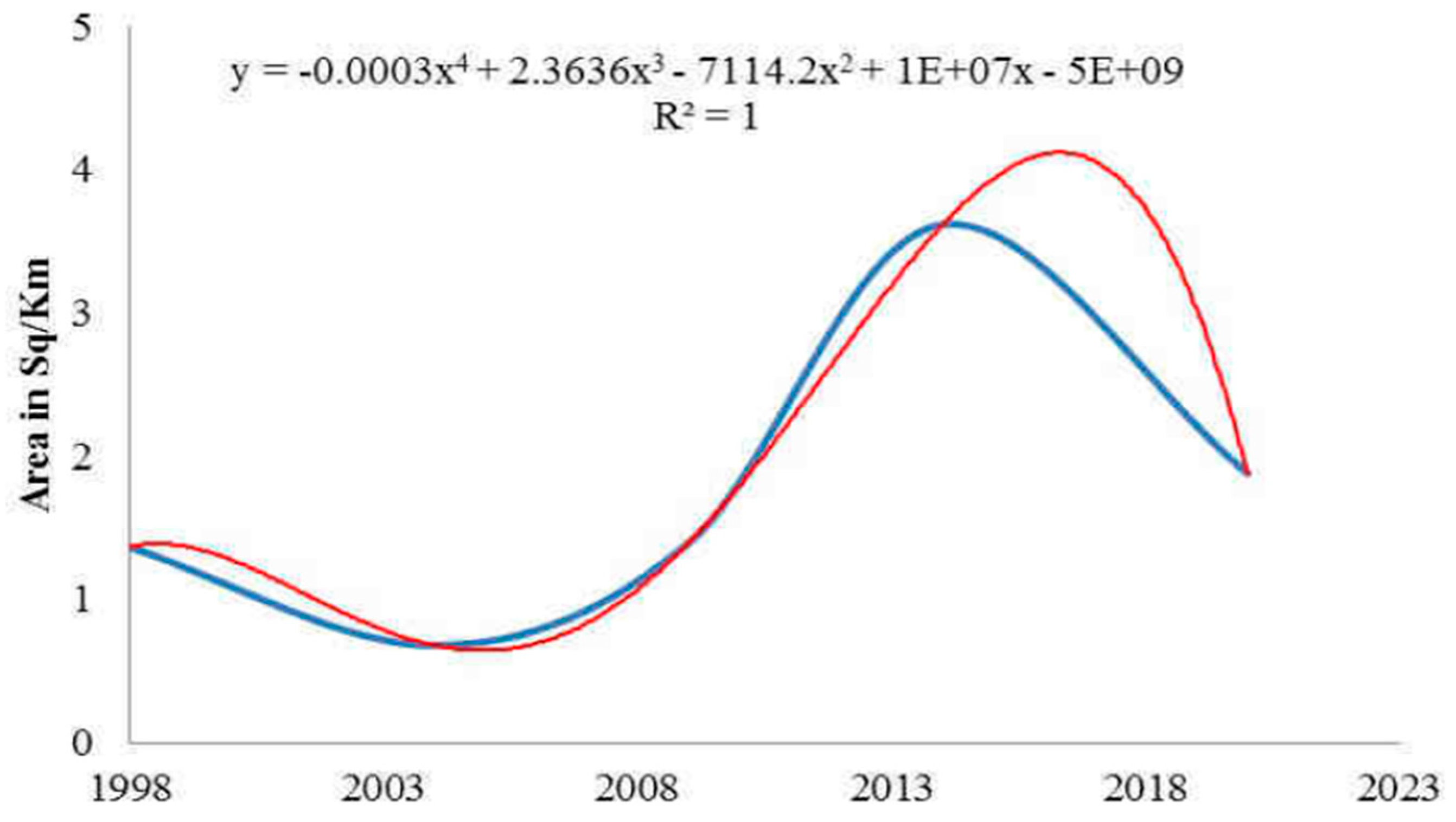
The reasons of this fluctuation are some rainy years and the discharge of domestic/ municipal wastewater in the open areas and the depression of the area. Since the command was given to assess surface water only and its characterizations were not assessed during the analysis. The R2 vale of polynomial regression is 1 of the data of all the studied years (Figure 11).
Conclusion
The study observed that the settlement patterns in Kotri area has changed rapidly since 1998. However, a significant change was noticed after the 2010 mega floods in this area, with more than 400 percent increase. The surface water has also increased due to the discharge of municipal wastewater in the open areas. there was a change in the settlement pattern of Kotri city with 40% between 1998 and 2020, 77% decrease in Bare-land was observed in 2020. Natural vegetation in the study area has decreased significantly with 4.4 Sq/ km in 2020, surface water-bodies in 1998 were 1.3 sq/km and in 2020 there is 1.8 Sq/km indicating 32% increase in surface water bodies. It was further revealed that settlement in Kotri has increased due to its geographical location, nearness of the major city of Hyderabad, and the establishment of the industrial zone and educational city near Kotri. It is therefore recommended that the government should pay attention towards this development for action towards provisions for city expansion.
References
- Akhtar, S. & Dhanani, M.R. (2013). Urban sprawl in Karachi. Global Advanced Research. Journal of Geography and Regional Planning 2(7): 160-171.
- Basit, M., Sajjad, S. H., Khan, M. I., Ali, A., & Kurshid, S. K. (2018). Spatio-temporal trends of urban population in Pakistan. Asian Journal of Multidisciplinary Studies, 6(8), 21- 26.
- Bisht, B.S., and Kothyari, B.P., (2001). Digital Land Cover Change Analysis of Garur Ganga Watershed Using GIS/Remote Sensing Technique, International Journal of Remote Sensing, 29 (3), pp 165-174.
- Cohen JE. (1995). How many people can the earth support? New York: WW Norton.
- Cohen, B. (2004). Urban Growth in Developing Countries: A Review of Current Trends and a Caution Regarding Existing Forecasts. World Development, 32(1), pp. 23-51. [CrossRef]
- Darshini Mahadevia (2008). Inside Transforming Urban Asia: Policies, Processes and Public Actions, Concept Publishers.
- DeFries, R., Rudel, T., and Uriarte, M. (2010). Deforestation driven by urban population growth and agricultural trade in the twenty-first century. Nature Geosci 3, 178181. [CrossRef]
- Economic and Social Survey of Asia and the Pacific (ESCAP) (2013). Forward-Looking Macroeconomic Policies For Inclusive And Sustainable Development, United Nations publication Sales No. E.13.II.F.2.
- Uma, J. and Mahalingam B. (2011). Spatio-Temporal changes of Land use and Land cover analysis using Remote Sensing and GIS: A case study of Kanchipuram District Coastal Stretch Tamil Nadu, International journal of Geomatics and Geosciences, 2:188-195.
- United Nations Development Programme (UNDP, 2019). Pakistan Annual Report. https://www.undp.org/pakistan/publications/undp-pakistan-annual-report-2019.
- Kotri Association Of Trade & Industry (2019). Jamshoro Chamber of Commerce & Industry; Pakistan.
- Lambin, E.F., Geist, H.J. and Lepers, E. (2003). Dynamics of Land-Use and Land-Cover Change in Tropical Regions. Annual Review of Environment and Resources, 28, 205-241. [CrossRef]
- Makhdoom, T. R. (2018). Employees exit from manufacturing organizations: Investigating the consequences. Pakistan Administrative Review, 2(2), 243-252. https://nbn-resolving.org/urn:nbn:de:0168-ssoar-58645-1.
- Newman P., Thornley A. (2000). World Cities and Urban Planning. Developing a conceptual framework. Planning Conference held at the LSE.
- Shimelis Gebriye Setegn, Ragahavan Srinivasan, Assefa M Melesse, Bijan Dargahi (2009). SWAT Model Application and Prediction Uncertainty Analysis in the Lake Tana Basin, Ethiopia, Hydrological Processes 24(3):357 - 367. [CrossRef]
- Zhang, D., Suganuma, T., Workman, J.L. (2013). Acetylation regulates Jun protein turnover in Drosophila. Biochim. Biophys. Acta 1829(11): 1218--1224. [CrossRef]
- Zubair, A. O. (2006). Change Detection in Land Use and land Cover Using Remote Sensing Data and GIS: A Case Study of Ilorin and Its Environs in Kwara State. https://www.geospatialworld.net/wp-content/uploads/2016/04/OpeyemiZubair_ThesisPDF.pdf.
Figure 1.
Satellite image of Kotri area, Pakistan.
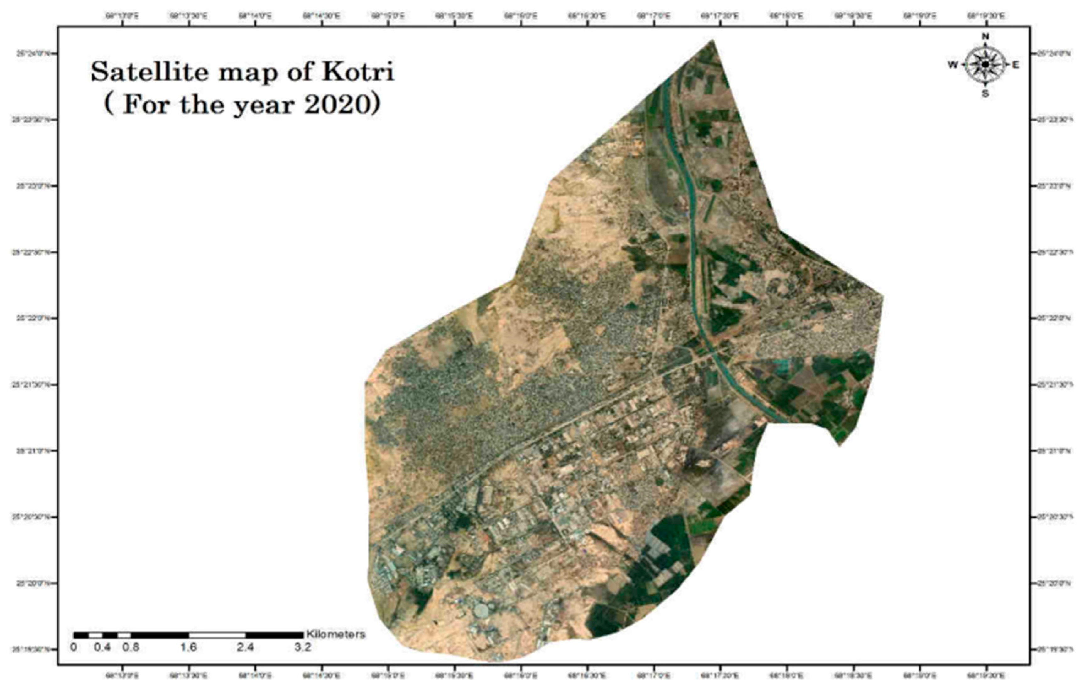
Figure 2.
Research design.
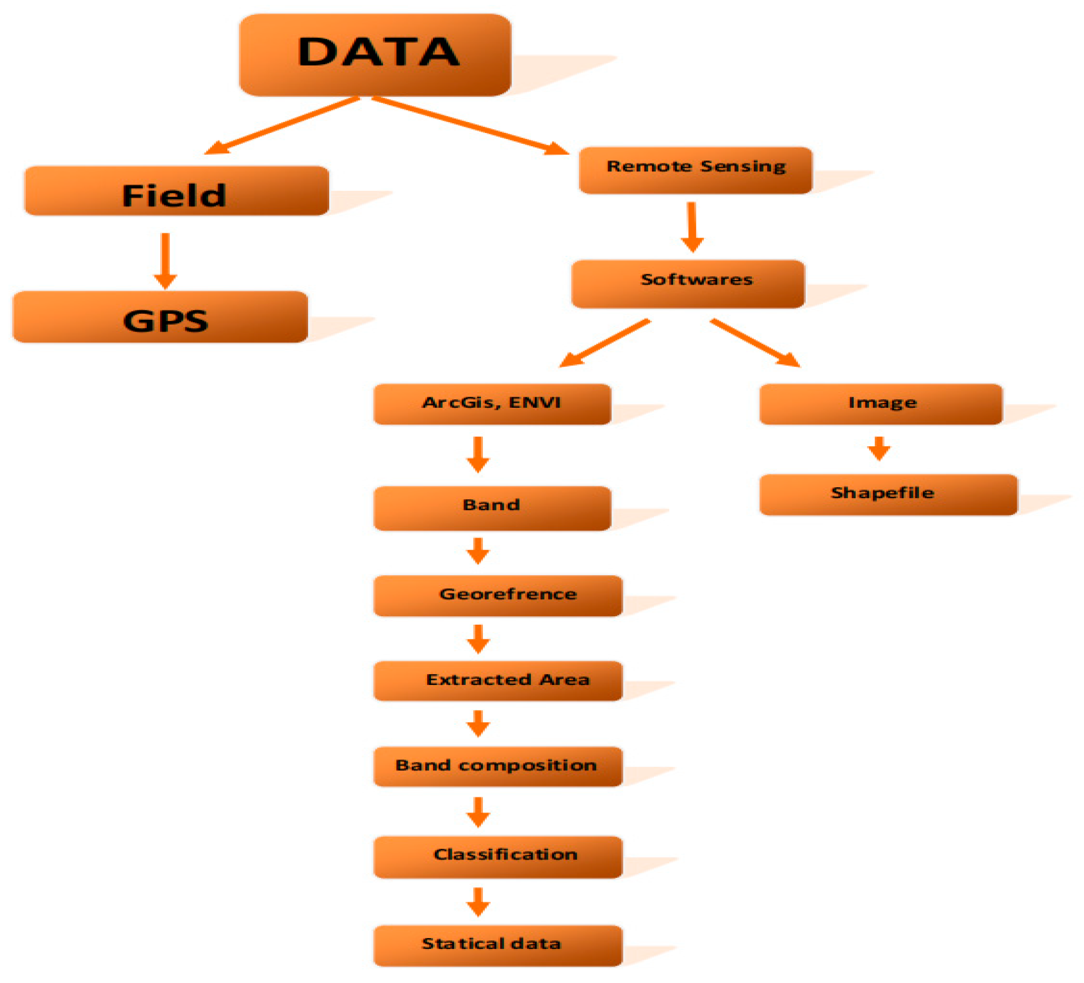
Figure 3.
Comparative Analysis of land cover and land use from 1998 to 2020.
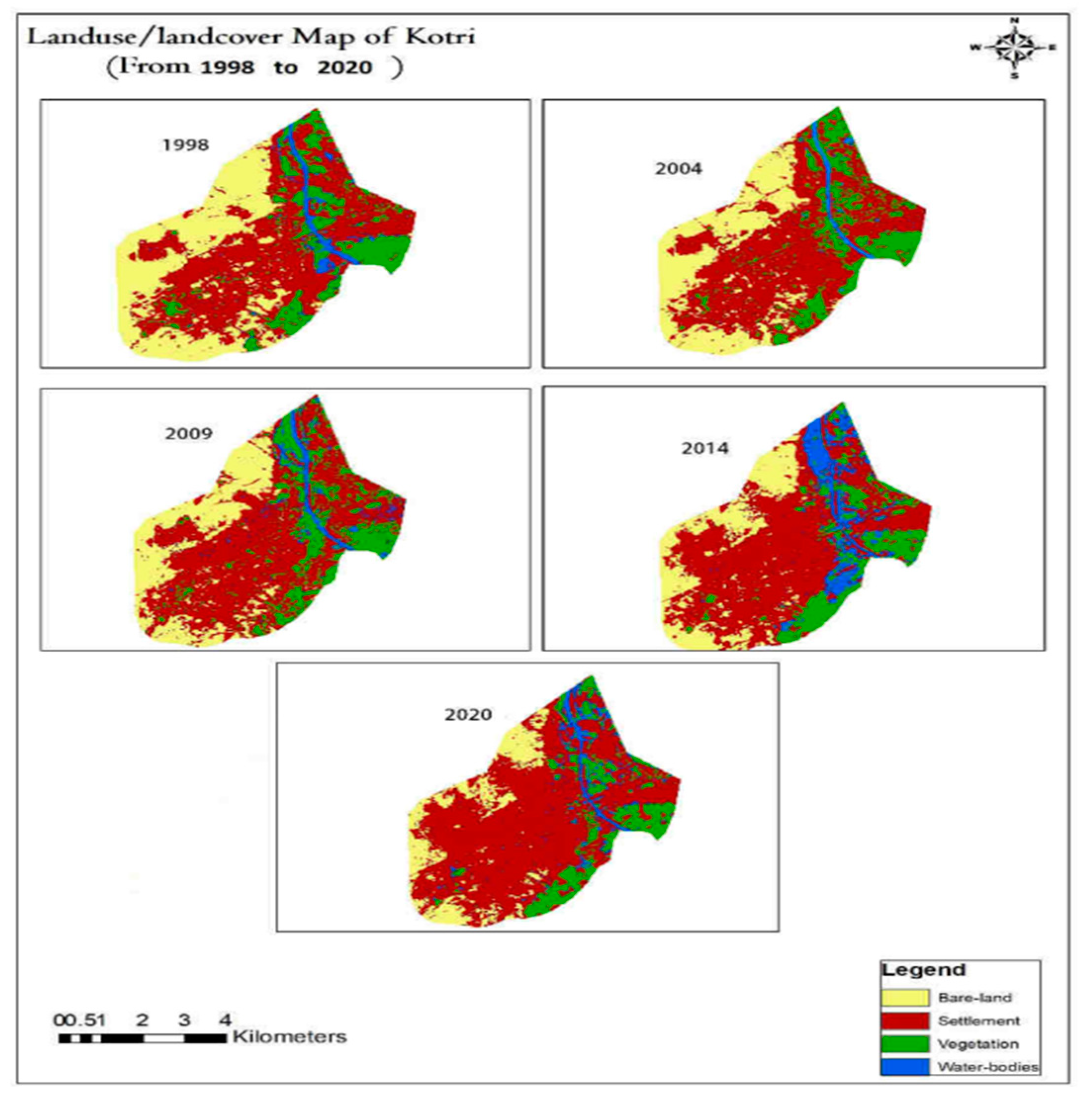
Figure 4.
A graphical representation of settlement changes in the study area from 1998 to 2020.
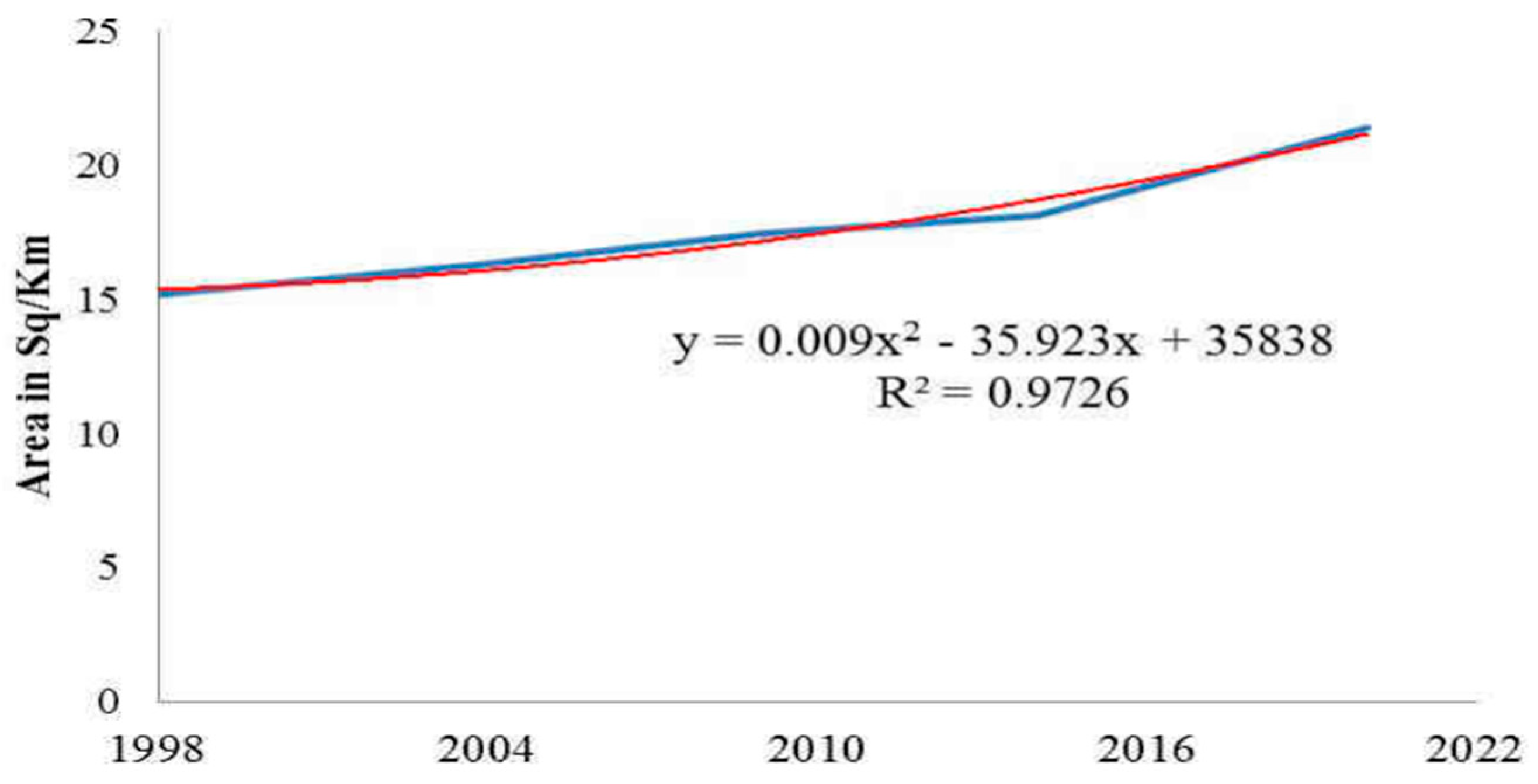
Figure 5.
Settlement changes in Kotri from 1998 to 2020.
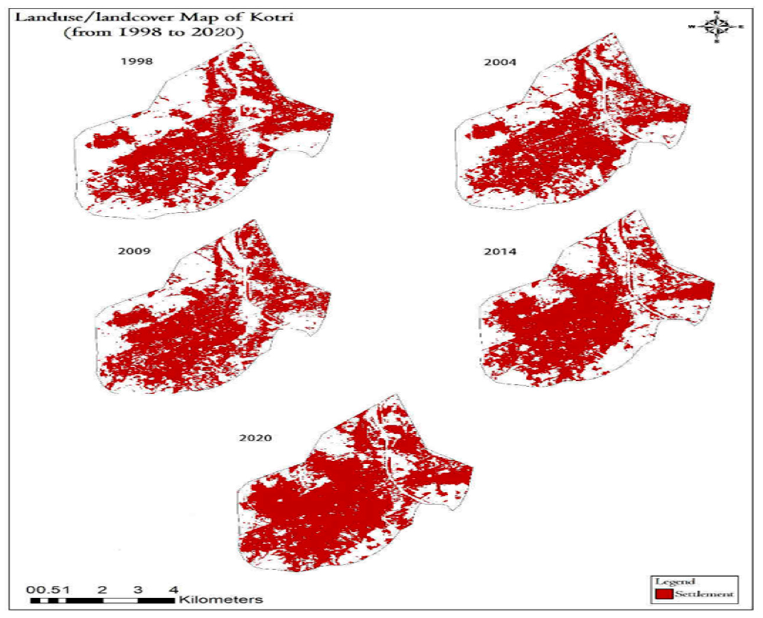
Figure 6.
A graphical representation of Bare-land changes in the study area from 1998 to 2020.
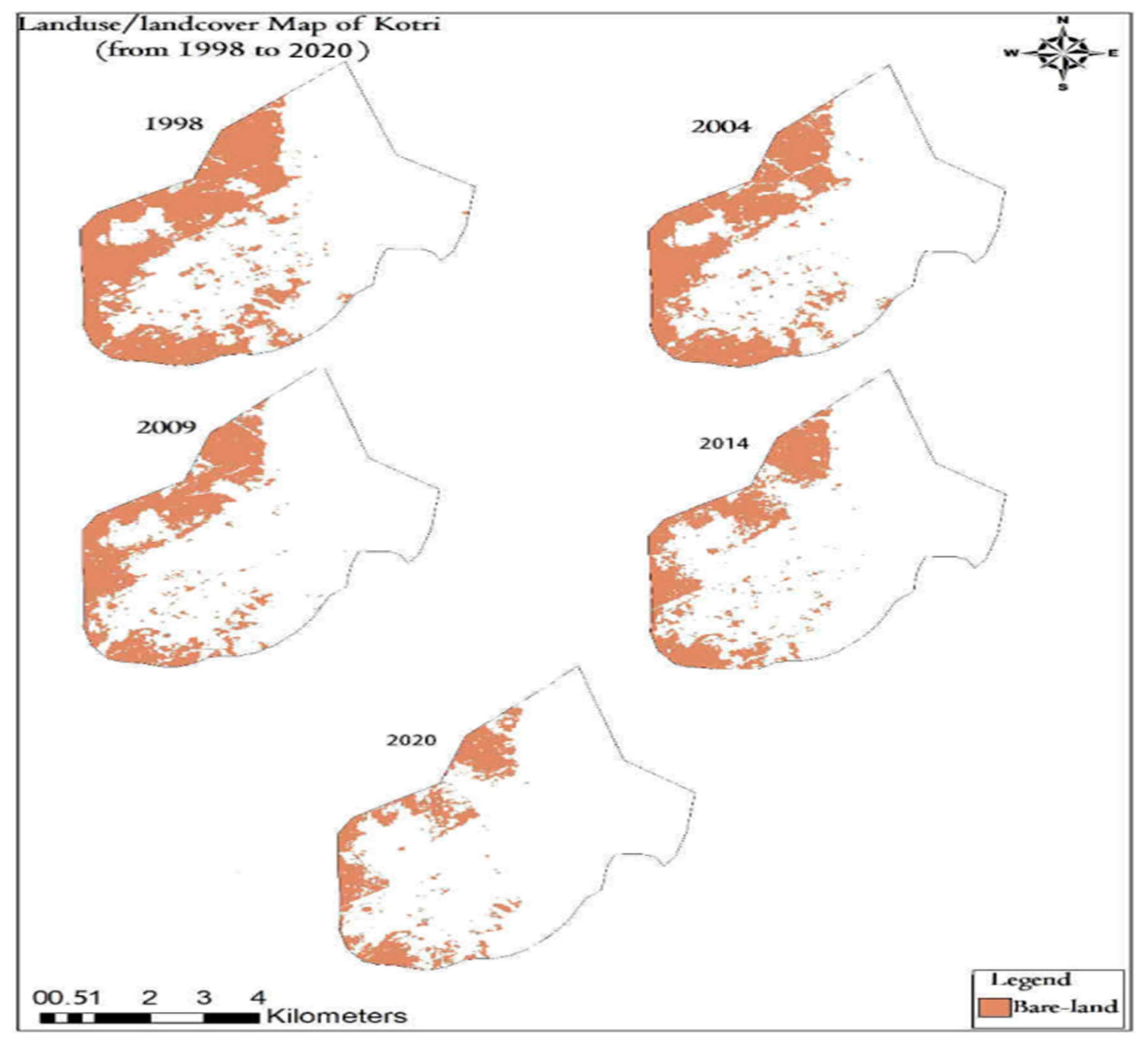
Figure 7.
Bare-land changes in Kotri from1998 to 2020.
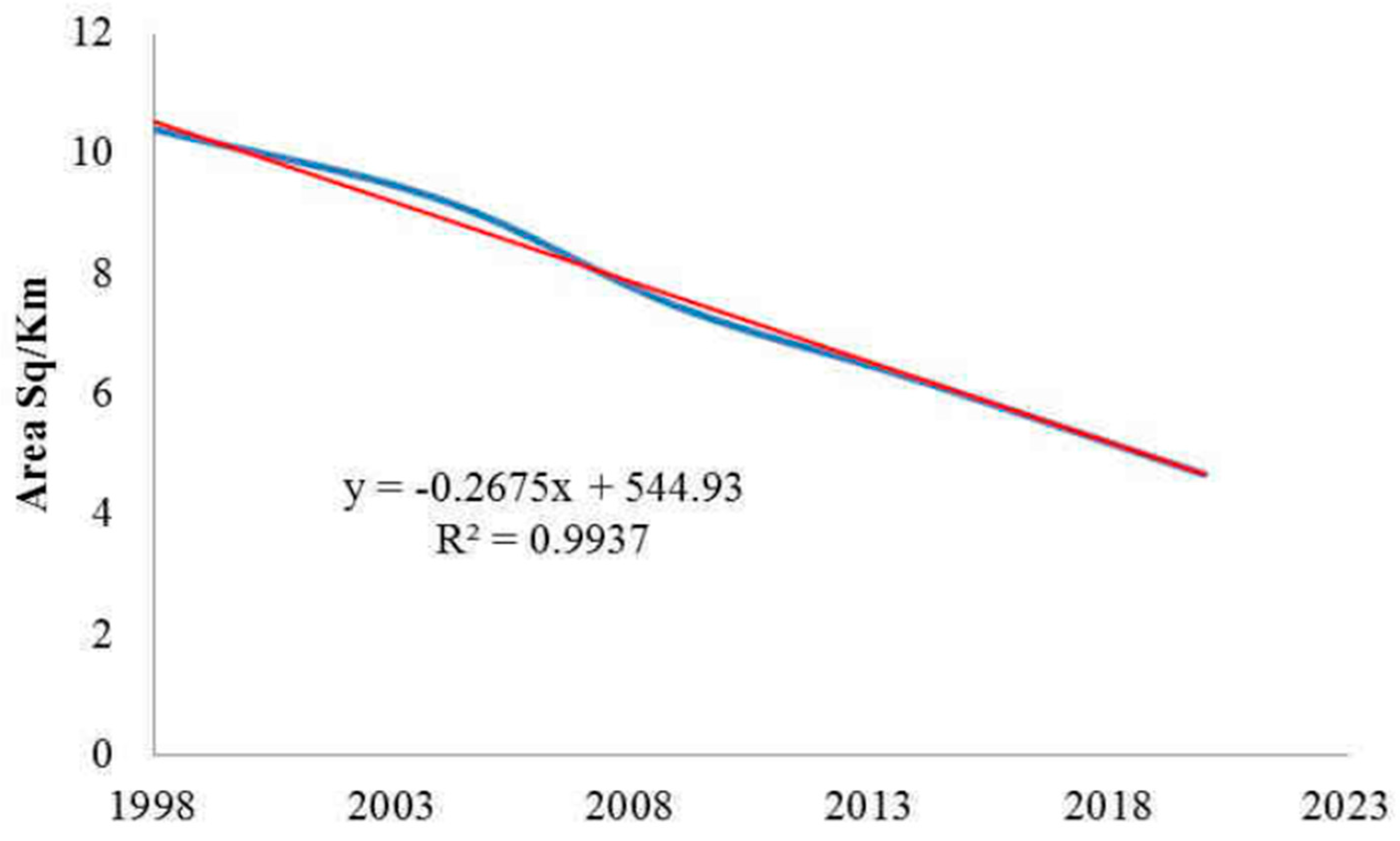
Figure 8.
A graphical representation of Vegetation changes in the study area from 1998 to 2020.
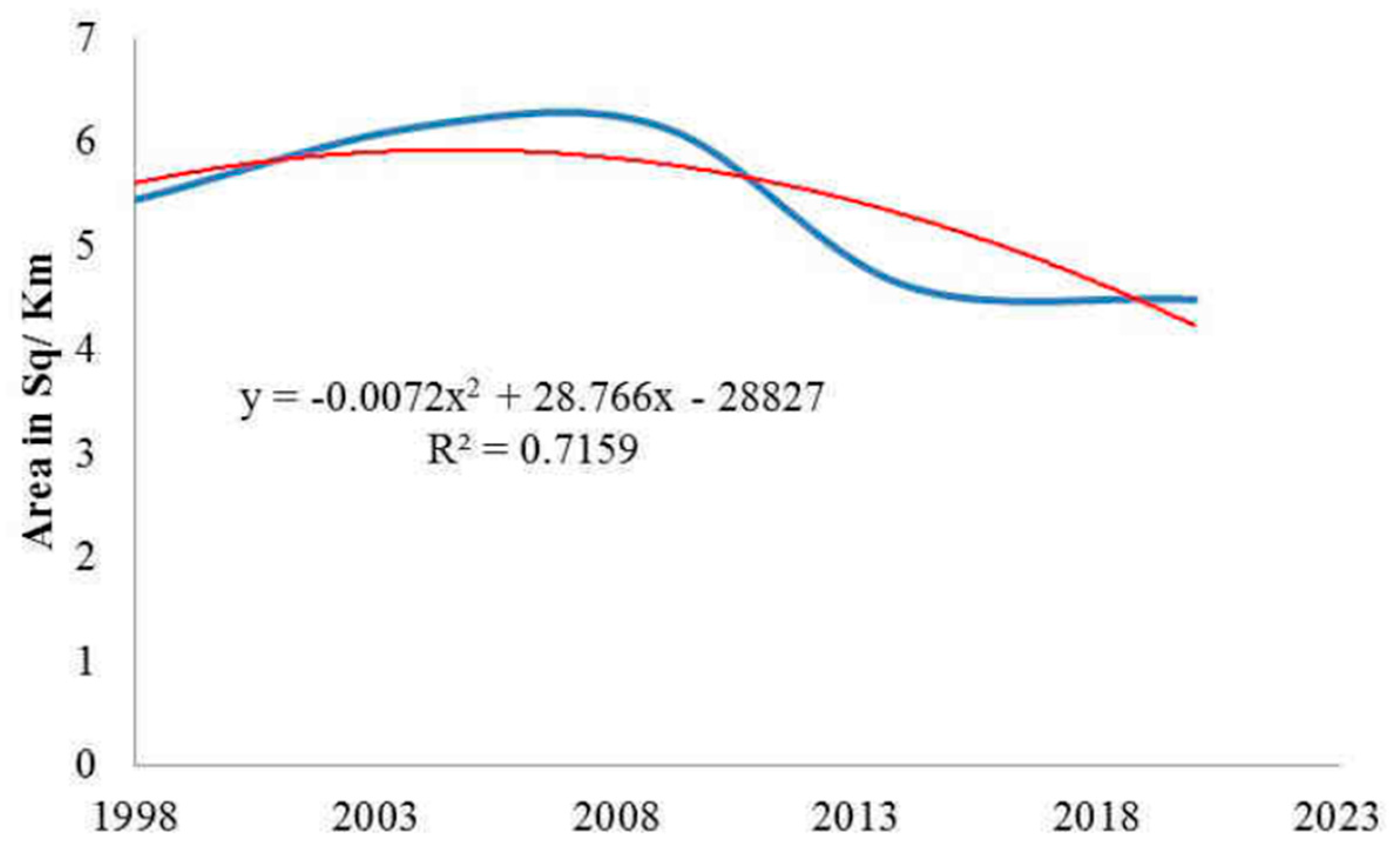
Figure 11.
Water-bodies changes in Kotri from 1998 to 2020.
Disclaimer/Publisher’s Note: The statements, opinions and data contained in all publications are solely those of the individual author(s) and contributor(s) and not of MDPI and/or the editor(s). MDPI and/or the editor(s) disclaim responsibility for any injury to people or property resulting from any ideas, methods, instructions or products referred to in the content. |
© 2023 by the authors. Licensee MDPI, Basel, Switzerland. This article is an open access article distributed under the terms and conditions of the Creative Commons Attribution (CC BY) license (http://creativecommons.org/licenses/by/4.0/).
Copyright: This open access article is published under a Creative Commons CC BY 4.0 license, which permit the free download, distribution, and reuse, provided that the author and preprint are cited in any reuse.


