Submitted:
30 November 2023
Posted:
07 December 2023
You are already at the latest version
Abstract
Tourism is widely recognised as a significant economic source for local communities. Nevertheless, tourism may potentially result in adverse effects on the environment. In order to mitigate adverse effects and enhance the advantages, tourism development necessitates a comprehensive planning process. In order to effectively manage and guide the growth of tourism, it is imperative to ensure that local-level spatial plans are integrated with national policies and regional strategies. The aim of this article is to investigate the impact of national policies and regional strategies on local spatial plans in tourism destinations, specifically, by analysing the land-use/land-cover changes along the western coastline of Mersin, with a particular emphasis on the Kızkalesi tourism destination.
Keywords:
tourism destinations
; tourism planning
; land-use/land-cover changes
; Kızkalesi
1. Tourism, Planning, and Land-Use/Land-Cover Changes
Tourism is commonly defined as a collection of activities involving the act of travelling to a specific destination that is separate from one's permanent place of residence with the intention of engaging in the consumption of specialised services [1]. In the pursuit of this objective, tourism makes use of various resources available within the destination itself [2]. This consumption process has a direct influence on the economic welfare of the tourism destination. Hence, the sector of tourism has garnered significant attention from numerous countries [1], being acknowledged as the foremost contributor to global exports and a crucial source of foreign currency and employment opportunities [3]. Tourism also plays a pivotal role in stimulating the growth of various economic sectors, including agriculture, manufacturing, and commerce. Although tourism can have favourable economic effects, it can also give rise to a range of issues if not adequately planned [1].
Tourism is typically carried out in locales that possess specific attributes, referred to as tourism destinations. The transformation of land-use/land-cover (LULC) in and around tourism destinations is an inevitable consequence of tourism growth [4,5,6,7]. To effectively address these changes, it is imperative to implement a comprehensive and coordinated planning approach [8] that encompasses various dimensions and operates at the national, regional and local levels. This approach should encompass the formulation of policies, strategies, and spatial plans in order to maximise the advantages and minimise the adverse effects associated with tourism development.
Tourism policies and strategies, once determined at the national or regional level, should be accompanied by coherent spatial plans at the local level. Spatial planning in tourism destinations serves as an operational tool for fostering the harmonious integration of the tourism sector with other sectors and establishing connections between various tourism destinations within a certain area or region [9]. The article posits that the lack or inadequacy of spatial planning during the process of tourism development in a particular destination may lead to permanent issues pertaining to spatial organisation, preservation of natural and cultural resources, and the establishment of social and technical infrastructure. The objective of the article is to examine the significance and role of spatial planning in tourism destinations, with the purpose of facilitating an integrated approach to tourism planning. This will be achieved through an analysis of an actual case study.
Turkey possesses a multitude of natural and cultural assets that present several opportunities for the expansion and development of its tourism sector. Since the 1980s, the government has implemented regulations and incentives to support tourism development as a significant economic sector in accordance with national policy. The initiation of tourism development in the Kızkalesi settlement, located in Mersin, Turkey, can be traced back to the 1980s. This development was undertaken in alignment with the national strategy and received further assistance from regional policies. The expansion of tourism development is bound to result in LULC changes in the settlement. However, the primary inquiry pertains to the effectiveness of the tourism planning process in managing and regulating these transformations. In response to the primary inquiry, this research investigates the historical evolution of tourism development in Kızkalesi. It does so by examining the influence and consequences of national policies, regional strategies, and local spatial plans on LULC changes. These changes are analysed through the use of visual materials, including satellite images and aerial photographs.
The research employs remote sensing technologies, geographic information systems, and satellite images to monitor and assess the LULC changes within the region of Kızkalesi. The process of image classification was conducted using open-source software applications, namely Google Earth Engine and QGIS. The utilisation of image classification techniques serves the objective of accurately analysing and comprehending the temporal variations in LULC patterns. The outcomes of the image classification were subsequently subjected to critical evaluation, taking into account the processes of tourism planning and their significance in guiding and regulating the tourism development in Kızkalesi.
2. Kızkalesi as a Tourism Destination
Kızkalesi is situated along the south-eastern Mediterranean coastline of Turkey, approximately 23 km southeast of the Erdemli district centre and 59 km southeast of the Mersin city centre (Figure 1). Kızkalesi is linked to the city centres of Erdemli and Mersin through the Mersin-Antalya regional highway, officially known as the D-400 Highway. Kızkalesi is an important neighbourhood within the Erdemli district, encompassing a significant archaeological site known as the ancient city of Korykos. The overall land area of the neighbourhood measures 20.147 square kilometres. Kızkalesi is populated by 1,781 residents as of 2022. The summer population of the neighbourhood experiences a significant rise, reaching roughly 40,000 people, consisting of both domestic tourists staying for short to medium durations as well as an additional influx of up to 100,000 individuals during weekends, which includes daily visitors [10].
The administrative boundary of the Kızkalesi neighbourhood is delineated by the Mintan River and Boynuinceli neighbourhood to the west, Ayaş neighbourhood to the east, Hüseyinler neighbourhood to the north, and the Mediterranean Sea to the south (Figure 2). Kızkalesi exhibits a close interconnection with its adjoining village, Boynuinceli, in terms of the influx of tourists and the continuity of the settlement system. Within the confines of the Kızkalesi neighbourhood, two distinct nodes of human habitation can be identified. The first is the urban and tourism hub, situated in the southern region. The second is the village and rural centre, located in the northern section. The metropolitan centre is divided by the D-400 Highway. In addition, there are discrete rural residential units, farms, and agricultural fields situated along the roads that extend into the northern direction.
The primary economic activity within the neighbourhood is centred around tourism, which spans a duration of around six months annually, commencing in May and concluding in October. In addition to tourism activities, local community also engages in agricultural activities, primarily focusing on vegetable cultivation. While the residents of the neighbourhood mostly employ in agricultural and husbandry activities throughout the year, they also make significant contributions to tourism activities during the tourism season.
The settlement's proximity to nearby centres, favourable climate conditions, the presence of a lengthy sandy beach with a Blue Flag designation, and the existence of ancient ruins in and around the neighbourhood centre have contributed to the attraction of tourism activities since the 1980s (Figure 2 and Figure 3a,b). Consequently, urbanisation by the influence of tourism development has experienced a notable rise, particularly along the coastline.
Tourism-related activities started in Kızkalesi by the 1970s as daily visits from Mersin city centre. As stated by Koca and Şahin, the accommodation sector in the specified region consisted of 14 hotels with a total capacity of 615 beds, 18 motels with a capacity of 430 beds, 38 pensions with a capacity of 1,740 beds, and 2 camping areas with a capacity of 200 beds [13]. Additionally, there were 856 summer houses available for tourists. The combined bed capacity, including summer houses, in 1994 amounted to 5,400. These establishments collectively hosted an estimated 30,000 foreign tourists and 146,000 domestic tourists, resulting in a total of 176,000 tourists for the year 1994 [13]. According to Koca and Şahin's prediction, the total number of visitors during the summer season in 1994, including daily visitors, amounted to 800,000 individuals [13]. The aerial photographs (Figure 4a,b) provide evidence of the rapid transformation of the physical environment, as the rural town underwent a significant shift to become a bustling tourism destination in a span of approximately ten years.
The tourism capacity of the settlement has undergone development through various means during 2000s (Table 1). This includes the construction of new accommodation units mainly as summer houses, as well as the enhancement of tourist experiences through the provision of facilities on public beaches. Additionally, efforts have been made to improve the technical infrastructure and increase the accessibility of the settlement. This has been achieved through the expansion of the D-400 Highway and the introduction of scheduled public transportation opportunities. According to the Kızkalesi Culture and Tourism Association, as for the year 2021, the neighbourhood boasts a total of 104 tourism accommodation establishments, offering a combined capacity of 2,100 rooms and 4,750 beds. In addition, during the past three decades, a significant number of private residences in the form of apartment blocks have been constructed in Kızkalesi with the purpose of serving as summer houses. Consequently, this tourism destination possesses the capability to house a substantial number of tourists and temporary residents, reaching into the hundreds of thousands, specifically during the summer season.
In the past thirty years, Kızkalesi has emerged as a notable regional tourism destination in the south-eastern Mediterranean area of Turkey, owing to its abundant and distinctive natural and cultural resources. However, the settlement has encountered specific problems as a result of the rapid growth of tourism; “…such as the pressure for development while the settlement is surrounded by natural and cultural conservation areas, huge population increase during tourism season that creates carrying capacity and management problems, difficulties in accessibility from distant locations, and the lack of comprehensive local spatial plan to direct changes in physical environment” [11] (p.30). This study posits that the aforementioned issues mostly arose as a result of the insufficient interconnectedness between tourism planning processes and tourism development in the settlement. The implementation of spatial plans for tourism growth was hindered by various factors, including their delayed introduction and influence from private interests. In order to explore this hypothesis, the study will assess the changes in LULC in relation to the policies, strategies and spatial plans involved in tourism planning.
3. Research Methodology
All human actions, particularly those related to development, have both direct and indirect effects on the environment. Several studies have been conducted to assess the overall environmental impacts of LULC changes [14,15,16]. Additionally, there is a wide range of research that specifically examines the effects of LULC changes on specific topics such as water resources [17,18,19], natural hazards [20,21], and forest areas [22,23,24].
Tourism is a significant catalyst that alters the environment [25]. The study of tourism development, as a significant human activity that has both direct and indirect effects on LULC changes, has been the subject of investigation by several researchers. Saha and Paul conducted an evaluation of LULC change resulting from tourism activities in West Bengal, India, during the period of 2009 to 2019 [7]. This evaluation was carried out through the use of satellite images. The study conducted by Boori, Voženílek, and Choudhary investigates the impact of tourism development on land-cover changes in the Jeseníky region [6]. This analysis is based on the use of Landsat satellite images captured in 1991, 2001, and 2013. Aji and Faniza's study looks at how the southern ring road has affected the land-cover changes in the Pacitan Regency region's tourist areas [4]. The authors utilise Landsat satellite images from 2008 and 2020 to conduct their analysis. The study undertaken by Atik, Altan, and Artar examines the effects of coastal tourism development on land-use changes in the Turkish Mediterranean region [5]. The researchers assess the influence of land-use plans implemented throughout various time periods on the environment. The aforementioned studies that specifically investigate the effects of tourism development on LULC change have reached the consensus that notable alterations have been detected in the areas surrounding the examined tourism destinations.
The objective of this research is to assess the LULC changes in the Kızkalesi region and its neighbouring areas using remote sensing techniques. Additionally, the research attempts to analyse the influence of the tourism planning process on these observed changes. The utilisation of remote sensing (RS) and Geographic Information Systems (GIS) is a common practice for the purpose of monitoring changes in LULC and establishing a significant study domain in this context. By employing this analytical methodology that serves as the fundamental framework for numerous research endeavours, the historical datasets can be proficiently utilised, thereby facilitating the generation of future forecasts. Various platforms and programmes are utilised for conducting LULC change analysis. There exist both commercial and open-source software applications for this methodology, which are particularly designed to be compatible with GIS. This study utilised Google Earth Engine and the open-source QGIS software to investigate LULC change in the region of Kızkalesi (Figure 5).
The Google Earth Engine platform, accessible at https://earthengine.google.com/, is a cost-free and open-source web-based platform that encompasses an extensive database of satellite images (such as Landsat, Sentinel, MODIS, etc.) with a storage capacity of many petabytes. Additionally, it incorporates climate and weather data, as well as geophysical datasets. The availability of a code editor that provides support for both JavaScript and Python programming languages facilitates the utilisation of RS and GIS analysis.
The QGIS software was utilised for the visualisation and computation processes of the classified images. QGIS is an open-source software application that undergoes regular updates and offers a range of supplementary features. It facilitates various spatial analyses, including spatial data generation, data processing, and data visualisation. Due to its open-source nature and cost-free availability, this software has gained significant traction in academic literature [26,27,28,29].
The study utilised cloud-free Landsat satellite images with a spatial resolution of 30 metres, covering the years 1984, 1994, 2004, 2011, and 2022. The selection of these specific years is based on a comprehensive analysis of tourism-related national policies, regional strategies, and spatial plans that are relevant to the case study area, aligning with the overall objective of the research. In the context of image classification, a total of four different land classes were determined, including artificial surfaces, vegetation, forest, and water surfaces. A set of 25 training and 10 test data points were selected for each class value in every image, resulting in a total of 175 data points used for the purpose of image classification. The Random Forest (RF) classification algorithm, which has been widely employed in the academic literature [30,31,32,33], has been utilised to determine accuracy values over the course of several years, yielding favourable outcomes. The obtained validation results exhibit a satisfactory level of accuracy, making them suitable for subsequent studies (Table 2).
The analysis was performed on two spatial scales. The first scale encompassed the entire western coastline of Mersin, with a particular emphasis on the Kızkalesi settlement located in the middle. The second scale specifically focused on the Kızkalesi settlement, with a circular radius of 1 kilometre. The evaluation of the outcomes of LULC classifications involves taking into account tourism-related national policies, regional strategies, and spatial plans.
4. Results and Discussions
4.1. The Spatio-Temporal Pattern of Land-Use/Land-Cover in the Western Coastline of Mersin and Kızkalesi
The settlement pattern in the western coastline of Mersin has historically been influenced by its mountainous terrain, resulting in a concentration of settlements along the Mediterranean Sea. The analysis of historical LULC change along the western coastline demonstrates a noticeable expansion of artificial areas, specifically built-up areas, over the course of time (Figure 6). It has been determined that there was a threefold growth in artificial areas from 1984 to 2022. The extent of vegetation area, encompassing both agricultural fields and maquis shrubland, has exhibited a decline, while forest areas have had a 1.5-fold increase due to afforestation efforts undertaken by government agencies targeting maquis shrubland (Figure 7-left, Table 3). Based on the implementation of afforestation efforts in the northern regions, it can be inferred that urban expansion has predominantly occurred in proximity to vegetation areas along the western coastline between 1984 and 2022.
The LULC change in Kızkalesi presents a distinct contrast to the western coastline region due to its location along the coastline and the predominant forest areas in its northern regions (Figure 6 and Figure 7). From the period spanning 1984 to 2022, there has been a notable increase in artificial areas in Kızkalesi, amounting to a multiplication factor of 6.4. As a result, artificial surface has emerged as the predominant form of land-use in Kızkalesi (Table 4). Upon observing the data presented in Figure 7-right, it becomes evident that while the forest areas have remained relatively stable, there has been a major decline in vegetation areas. From this, it can be inferred that the development activities in Kızkalesi have primarily taken place on agricultural lands and maquis shrubland.
Between the years 1984 and 2022, development activities have resulted in detrimental effects on vegetation areas, both along the western coastline and in Kızkalesi. However, it is worth noting that forest areas have not been significantly impacted by these development activities. The primary factor contributing to the unsuitability of forest areas for habitation is the presence of steep slopes and limited accessibility. In spite of the growth in the artificial area observed during the 1990s, the population of the settlement started to decrease by the 2000s and then remained relatively stable with minor fluctuations (Figure 8). The expansion of the built environment throughout time, along with a consistent population size, indicates that the primary factor influencing the physical landscape of the settlement is the presence of tourism-related facilities [34] (p. 958).
4.2. The Spatio-Temporal Pattern of Land-Use/Land-Cover in the Western Coastline of Mersin and Kızkalesi
The history of tourism planning in Turkey has been traced back to the 1960s [37]. During this period, Turkey embarked on a planning phase aimed at regulating its economic activities, which commenced in 1963 [38]. Tourism has been acknowledged as a subsector within the framework of national development plans, with the primary goals of utilising the potential of tourism, generating revenue from tourism activities, establishing essential infrastructure for providing services to domestic tourists, and ensuring an ideal balance between the preservation and development of tourism destinations [39]. In order to achieve national tourism objectives, substantial investments were made in tourism regions to encourage mass tourism and coastline tourism activities. As a result, tourism emerged as a prominent economic sector in Turkey, particularly after the 1980s. According to Oskay, the implementation of Law of Tourism Incentive No. 2634 has proven to be successful in stimulating tourism activities by strategically channelling tourism investments towards locations with high potential, and utilising incentives, financial assistance, and subsidies [40].
The initiation of tourism development in Mersin, particularly along the western coastline and in specific tourism destinations such as the settlement of Kızkalesi, has been attributed to the implementation of national and regional tourism policies and strategies. This development primarily took place during the 1980s and involved the construction of summer houses and hotels, primarily catering to domestic tourism [11]. The Ministry of Public Works and Housing (at that time) produced the Western İçel Coastal Development Plan in 1988 with the aim of guiding investments in the tourism sector. The proposed plan encompasses the entirety of the western coastline of Mersin province, spanning from the Erdemli district to the Anamur District. It puts forth suggestions for the development of tourism areas, daily tourism activity areas, and tourism centres within the region [11]. The proposal recommended designating the eastern and southern regions of Kızkalesi as areas for tourism development. At that point in time, Kızkalesi had emerged as a prominent destination within the region, leading to a notable increase in tourism investments.

Table 5.
Tourism planning-related policies, strategies, and planning documents and their impact on the tourism development along the western coastline of Mersin .
Table 5.
Tourism planning-related policies, strategies, and planning documents and their impact on the tourism development along the western coastline of Mersin .
| Year | Document / Plan | Scale / Type | Decision / Impact on Inner Coastline Tourism Development |
|---|---|---|---|
| 1982 | Law no. 2634 on Tourism Incentives |
National Level Legal Document |
Increase in the number of summer houses constructed |
| 1988 | Western İçel Coastal Development Plan by the Ministry of Public Works and Housing (at that time) |
Regional Level 1/25,000 scale spatial plan |
Increase in the number of summer houses constructed |
| 2006 | 9th National Development Plan 2007-2013 |
National Level Strategic Document |
Tourism as one of the basic economic sectors to be supported |
| 2007 | Tourism Strategy of Turkey 2023 by the Ministry of Culture and Tourism |
National Level Strategic Document |
Tourism centres in the western coastline declared |
| 2010 | Mersin Tourism Master Plan (RIS-Mersin) |
Regional Level Strategic Document |
Tourism as one of the three pillars of regional/local economy |
| 2013 | Environmental Master Plan for Adana and Mersin Planning Region by the Ministry of Urbanization and Environment (as named at that time) |
Regional Level 1/100,000 scale spatial plan |
New tourism development zones especially for the construction of summer houses |
| 2014 | Çukurova Regional Plan 2014-2023 by Çukurova Development Agency |
Regional Level Strategic Document |
Keeping the existing situation along the inner coastline |
The inception of the tourism planning initiative in 1988 has evolved into a more comprehensive process of tourism planning in the 2000s, guided by national and regional policies and plans. In an endeavour to enhance the management and execution of strategic planning initiatives and foster collaboration between the public and private sectors in the field of tourism, the "Tourism Strategy of Turkey 2023" and the "Activity Plan for Tourism Strategy of Turkey 2007-2013" were officially released on February 2007 [41]. The Ministry of Culture and Tourism has taken on the role of coordinator in order to facilitate the coordination of tourism-related activities and provide guidance to the tourism and travel industry throughout the many stages of production, management, and implementation. This coordination is carried out with a participatory planning perspective, involving all relevant stakeholders. The strategy plan has been formulated in accordance with the goals outlined in the 9th National Development Plan 2007-2013 [42], which stipulates the need for the formulation of a comprehensive tourist industry master plan to facilitate the sustainable and robust growth of the tourism sector.
The Mersin Regional Innovation Strategy, implemented in 2008, was a notable regional initiative aimed at revitalising the economy in Turkey after the turn of the millennium [43]. It was the final dissemination of the RIS-Mersin Project, which took place from 2006 to 2008. The strategy document was not deemed an official document. Rather, it served as a bottom-up advisory document generated by local initiatives with the purpose of guiding investments and planning decisions [44]. The primary objective of the strategy is to identify the key sectors that drive innovation in the local economy. The sectors identified are logistics, agriculture-food industry, and tourism [45]. Due to the vulnerability of these key economic sectors to global financial and economic crises, local initiatives aim to enhance the resilience of the local economic framework by increasing its complexity. In order to attain the desired level of thickness, sector-specific forums were established for each, with representatives from relevant public and private sectors. The aforementioned platforms have formulated sector-specific visions, identified objectives for each sector, and put forth appropriate initiatives along with sector-specific master plans [43,44].
One of the sector-specific master plans derived from the Mersin Regional Innovation Strategy is the Mersin Tourism Master Plan 2010. This plan encompasses strategies pertaining to the socio-cultural, economic, and organisational aspects of tourism. Nevertheless, the spatial dimension within the master plan exhibits a relative lack of strength. The master plan focuses solely on identifying the sub-regions of tourism activities in Mersin and the overall bed capacities in these regions [46]. Consequently, the plan's scope for innovation is likewise restricted. The Mersin Regional Innovation Strategy has been found to generate economic enthusiasm and foster improved trust and confidence at the local level [44,47]. Furthermore, the recommendations put forth in the Mersin Tourism Master Plan 2010 have played a crucial role in shaping subsequent regional planning attempts.
At the regional level, there are two different plans encompassing Kızkalesi and its rural hinterland. The initial plan under consideration is the "Çukurova Regional Plan 2014-2023," which has been produced by the Çukurova Development Agency for the TR62 NUTS-2 region covering the provinces of Adana and Mersin [48]. The primary objective of the Çukurova Regional Plan 2014-2023 is to transform the region into a globally recognised hub of attraction and a prominent centre for production activities. The prioritisation of harnessing the regional tourism potential through active utilisation is a key objective of this strategic target. Similar to other regional plans formulated by other development agencies, this particular plan places a strong emphasis on abstract and conceptual spatial considerations. Instead, comprehensive sectoral analyses and proposals have been systematically produced. The regional plan encompasses a range of comprehensive tourism strategies for the region, many of which have not been translated into specific spatial decisions. The regional plan aims to establish effective connections between the regional and tourism destinations in south-eastern Anatolia and inner Anatolia. However, it is worth noting that the western section of Mersin has not been thoroughly taken into account. Therefore, the regional plan does not place any particular emphasis on Kızkalesi and its rural hinterland.
The second regional plan is the "1/100,000 scale Environmental Master Plan for Adana and Mersin Planning Region," which was revised and approved in 2017 by the Ministry of Environment and Urbanisation (as named at that time). The objective of this plan is to establish a sustainable and liveable rural and urban environment in the provinces of Mersin and Adana, with a target year of 2025 [49]. Different from the Çukurova Regional Plan 2014-2023, its emphasis is on the spatial aspects of the regional development. The objective of the plan is to protect the agricultural, touristic, and historical identity while also guiding development in a systematic manner, adhering to the planning principles established in alignment with Turkey's national development plans and sectoral development objectives. The tourism policies outlined in the environmental master plan aim to facilitate the development of sun-sand-sea tourism while simultaneously promoting the diversification of alternative tourism activities within the region. These policies are designed to enhance the economic benefits derived from tourism by increasing the overall number of visitors to the region.
The environmental master plan’s proposal for Kızkalesi and its surrounding rural hinterland aims to maintain the current state of affairs. The current tourism facilities lack a distinct categorization within the legend categories, as they are all encompassed under the designation of "preferential land-use area," which is described as comprising tourism as well as the inclusion of housing, complementary commercial activities, and areas dedicated to social, cultural, and technical infrastructure [50] (p. 4). The preferential land-use area legend category provides opportunities for the development of mixed-use areas. This implies that the inclusion of tourism facilities is suggested within the context of mixed-use areas. The plan does not provide specific measurements for the size of tourism areas. However, it is anticipated that 50% of preferential land-use areas will consist of tourism facilities. All projections in the plan are based on this assumption, as indicated in the planning report [49] [p. 20).
The influence of national and regional tourism policies on LULC change along the western coastline of Mersin during the 1980s was found to be limited, with the exception of the first establishment of summer houses by the beginning of 1990s (Figure 9). Nevertheless, the national tourism policies implemented in the early 2000s were supported by regional strategies and plans in the following decade. These collective efforts had a significant influence on the changes in LULC seen along the coastline. The growth pattern, which initially emerged as nodes in certain tourism destinations during the early 2000s, has evolved into a linear tourism corridor through the establishment of tourism facilities and construction of summer houses along the D-400 Highway.
The various policies, strategies, and plans implemented at both national and regional levels exert a significant influence on the development of tourism in Kızkalesi. The upward trajectory of tourism in Kızkalesi commenced throughout the 1990s. The tourism capacity of the settlement has undergone development through various means. This includes the construction of new accommodation units and summer houses, the enhancement of tourist experiences through the provision of facilities on public beaches, the improvement of technical infrastructure, the increased accessibility of the settlement through scheduled public transport opportunities, and the expansion of the main highway. The escalating need for tourism accommodation units, tourism services, and infrastructure necessitates the implementation of a spatial planning effort for effective direction and management.
4.3. Spatial Plans and Land-Use/Land-Cover Change in Kızkalesi
The spatial plans in the Turkish planning hierarchy [37] have the objective of directing and monitoring the spatial (re)development of cities, as outlined in the legislation known as the Law of Spatial Development No. 3194. Spatial planning has a crucial role in determining the direction and size of urban expansion as well as shaping future land-uses, population densities, transportation systems, and infrastructure development. Focusing on spatial organisation and directed by local-level governmental institutions, spatial plans are considered as local-level development plans.
Spatial plans are mainly generated by municipalities. Consequently, appreciating the changes in the municipal administrative system is essential for assessing the past course of the spatial planning process. Changes in the administrative system may lead to alterations in both administrative boundaries and corresponding responsibilities. The administrative system in Kızkalesi has undergone significant changes in recent decades, resulting in direct impacts on the spatial planning system (Figure 10).
Kızkalesi has been a rural village within the Ayaş Village in the Erdemli District since 1989. The population of Kızkalesi experienced a rise to 3,091 people during the 1990 Census, which coincided with the growth of tourism activities in the area. Due to the increase in population, Kızkalesi was officially designated as a town municipality in 1994 with the purpose of effectively addressing administrative issues and guiding the process of urbanisation within the settlement [13]. Since the year 2013, Kızkalesi has been recognised as one of the four town municipalities, along with Limonlu, Kocahasanlı, and Narlıkuyu, within the administrative authority of the Erdemli District. Kızkalesi constituted an autonomous urban settlement, overseen by the local municipal administration responsible for the regulation and authority over spatial planning. Following the implementation of administrative system changes and the revision of administrative boundaries of metropolitan municipalities in 2013, the Kızkalesi Municipality was disbanded. Consequently, the settlement was designated as a neighbourhood and placed under the jurisdiction of the Erdemli Municipality. The disbandment of Kızkalesi Municipality has resulted in the transfer of spatial planning authority at the local level to Erdemli Municipality.
Owing to these modifications to the local administrative structure, the history of the settlement's spatial planning process can be divided into three phases: initial planning implementations since 1989 directed by partial development plans prepared by Kumkuyu Municipality (of the period); partial and comprehensive planning applications between 1989 and 2013 under the authority of Kızkalesi Municipality (of the period); and partial and central planning implementations after 2013 within the control of Erdemli Municipality (Figure 10).
The settlement was developed piecemeal by partial development plans during the early urbanisation period in the 1980s and 1990s. The preparation of the 1/1,000 scale implementation plan started right after the establishment of Kızkalesi Municipality in 1993. Nevertheless, the municipality faced a deficiency in both technical and human resources necessary to carry out the spatial planning process. Consequently, they sought assistance from the central government. The preparation of base maps required for the spatial plans by the Provincial Bank (a former central public institution in charge of planning and infrastructure investments) has taken a long time and was completed in 2004 [11]. Due to the urgent need to control and direct increasing demands for new construction, especially in the southern part of the D-400 Highway during the 1990s, the development activities have been arranged by partial development plans prepared on single cadastral parcel or a group of parcels with the application of the landowner or the developer. In 2005, Kızkalesi Municipality (of the time) prepared and approved the 1/1,000 scale implementation development plan (Figure 11). The main aims of the implementation plan were to control changes in the physical environment, to direct especially tourism-related investments, and to achieve healthier development in the urban centre. The implementation plan proposed a building layout with a maximum 5-storey height. Outside the planning boundary, developments based on partial plans have continued (Figure 12a,b).
Following the local elections on March 2014, the Kızkalesi Municipality disbanded, resulting in the transfer of spatial planning authority and responsibility for monitoring spatial development and implementation plans to the Erdemli Municipality. Under the recently implemented administrative system at the municipal level, the Mersin Metropolitan Municipality has been designated as the primary authorising authority for all spatial planning activities under the province's jurisdiction.
The spatial implementation plan was modified in December 2013, just before the disbandment of Kızkalesi Municipality. The primary focus of the revised plan's land-use proposal is the development of residential areas for tourism and summer house purposes, as depicted by the yellow colour in Figure 13. Additionally, there are limited provisions directly for tourism facilities, represented by the light pink/orange colour in Figure 13. The plan also includes designated areas for public use, including administrative units, schools, health care centres, and green spaces. The municipality grants permission to all buildings to use their ground floors for commercial activities through the issuance of permits. The revision plan has resulted in an increase in development rights and an expansion of the boundaries pertaining to the built-up area. The maximum height for buildings, which was 5-storeys in the previous plan, has been revised up to 12-storeys at specific locations. Kızkalesi Municipality Council authorised the increase in development rights, as requested by landowners during the revision plan preparation phase [51], and subsequently endorsed it in the plan revision.
The revised implementation plan, which was approved in 2013, is currently in force at a scale of 1/1,000. Erdemli Municipality is responsible for the preparation and assessment of plan modifications, which may be required or recommended by landowners. These modifications are then submitted to the Mersin Metropolitan Municipality for the purpose of obtaining final approval.
During the 1980s, Kızkalesi has been one of the attractions, especially due to the increase in domestic tourism demand. However, the predominant form of tourism in this area was daily tourism focused on beach activities, which did not necessitate the presence of complex tourism infrastructure. In the aftermath of the 1990s, there has been a notable increase in the demand for tourism infrastructure catering to short- to medium-term accommodations, as well as an associated increase in the development of summer houses. These factors have played a significant role in shaping the LULC changes observed in Kızkalesi (Figure 14). The initiation of this process can be linked to the implementation of national policies for tourism incentives in 1982 as well as the subsequent approval of the Western İçel Coastal Development Plan in 1988. The Western İçel Coastal Development Plan has been crucial in establishing the overall land-use framework in the region, thereby empowering local municipalities to supervise and direct the processes of spatial plans. Nevertheless, small-scale municipalities faced limitations in terms of both human capacities and financial resources, which hindered their ability to effectively manage spatial planning processes in a sustainable manner. Consequently, these municipalities opted to guide spatial development through the utilisation of partial development plans. These plans entail the allocation of development and planning rights for specific plots or lots, typically in response to requests made by the respective owner or developer. In the context of such small communities, the prevalence of kinship relations and the influence of personal expectations have led to the unregulated allocation of densities and development rights. Furthermore, the implementation of piecemeal development has led to the creation of a physical environment that lacks harmony, as the allocation of development rights may differ even among adjacent plots or lots.
The table in Figure 15 illustrates a significant alteration in LULC within the time frame spanning from 1994 to 2004. The process of development has been in progress at that exact period where there was a lack of a comprehensive and integrated spatial planning process. The implementation of partial plans during this time period had an impact on the settlement pattern. The implementation plan was produced in the subsequent year of 2004, serving as a means to formalise the previously developed built-up area during the 1980s and 1990s. The majority of the planning area has already undergone development (Figure 15), and the implementation plan was mostly created to provide justification for the current state of the settlement. In conjunction with the initial spatial plan, national policies and regional tourism strategies have been formulated, and additional regional plans have been drafted. The Kızkalesi Municipality made amendments to the implementation plan in 2013, resulting in an expansion of the built-up area and increased densities. These changes were not primarily driven by national or regional policies and plans but rather by the approaching municipal administrative system change in 2014. Similar to the partial development process, during which the prioritisation of private interests and effective utilisation of land were paramount, the subsequently formulated implementation plan was unable to propose alternatives but rather aimed to formalise the existing situation. Furthermore, the 1/1,000 scale revision implementation plan resulted in increased densities, compounding challenges related to service provision.
5. Conclusions
Tourism is often regarded as a facilitator for economic development, particularly in small settlements, yet it necessitates the implementation of tourism planning. It is critical to carefully investigate and preserve the spatial dimension in which tourism takes place, particularly in relation to locales with distinct characteristics, in order to comprehensively assess the various consequences of tourism on different sectors and localities. In order to mitigate negative impacts, it is essential that the process of tourism planning be undertaken in a systematic manner. Additionally, it is crucial to ensure that tourism policies and strategies at both the national and regional levels are effectively supported by spatial plans at the local level.
Kızkalesi has been facing multiple challenges, particularly concerning the problems of excessive tourism and the occurrence of ghost town duality [11]. In instances of increased demand (Figure 16), the spatial environment's carrying capacity is mostly surpassed by short-term and daily visits, as opposed to stays of medium-term stays. The settlement was primarily comprised of seasonal structures that were not utilised for half of the year. During the period of off-season, a substantial number of commercial establishments experience temporary closure, and there is a decrease in the availability of public services. The study argued that the current problems in Kızkalesi can be explained by the fact that spatial planning efforts were adopted following the development of tourism. To explore the aforementioned argument, the study conducted a comprehensive analysis of the relationship between tourism planning processes and land-use/land-cover changes in the particular setting of Kızkalesi.
By conducting an analysis to determine land-use/land-cover changes in conjunction with tourism planning in Kızkalesi, it has been determined that throughout the 1980s, the primary emphasis on the physical environment was predominantly directed towards the provision of summer houses and a limited number of hotels. However, there was a notable lack of consideration given to accommodating daily visitors and facilitating short-term stays. The spatial environment during the 1980s and 1990s was influenced by the preferences and financial motivations of private developers and investors who were guided by partial development plans. During this period, there has been a significant increase of artificial areas in Kızkalesi, whereas the extent of vegetation areas has experienced a decrease. However, it should be noted that throughout this time, there was a lack of comprehensive spatial plan, despite the presence of tourism strategies at the regional level. The implementation plan created in 2004 primarily aimed to formalise the pre-existing physical environment and grant equivalent development rights for previously undeveloped areas. In conclusion, the analysis has demonstrated that the spatial planning was ineffective in guiding the growth of tourism in the settlement.
Spatial planning serves a crucial role in the sustainable development of tourism destinations by ensuring the effective utilisation of resources and the promotion of long-term viability. The case study examination highlights deficiencies within the policy and spatial planning frameworks, serving as an illustrative example for comparable settlements. The case study analysis provides remarkable insights that can be applied to the consideration of the relationship between policy and planning. Utilising a comparable approach would make it easier to look at different settlements or do comparative analysis, which would help us understand other problems and ow they affect long-term spatial planning methods. The analysis of the Kızkalesi example demonstrates that the lack of consideration for the spatial aspect in national tourism plans has resulted in an unplanned settlement pattern.
Author Contributions
Conceptualization, Yasemin Sarıkaya Levent, Ezgi Şahin and Tolga Levent; methodology, Yasemin Sarıkaya Levent and Ezgi Şahin; formal analysis, Ezgi Şahin; investigation, Ezgi Şahin, Yasemin Sarıkaya Levent and Tolga Levent; data curation, Ezgi Şahin; writing—original draft preparation, Yasemin Sarıkaya Levent and Ezgi Şahin; writing—review and editing, Yasemin Sarıkaya Levent and Tolga Levent; visualization, Yasemin Sarıkaya Levent and Ezgi Şahin. All authors have read and agreed to the published version of the manuscript.
Funding
This research received no external funding.
Acknowledgments
The earlier discussion about the scope of this article has been conducted by Yasemin Sarıkaya Levent and Ezgi Şahin during the International Tourism Conference 2022 through the presentation titled “The Role of Spatial Planning in Tourism Development: Opportunities and Challenges”. Initial research on Kızkalesi spatial planning process has been published as "Turkish case study analysis and policy recommendations", the output of the “SPOT: Sustainable Spatial Planning of Tourism Destinations” project granted by European Commission under the Erasmus+ Programme (2019-1-PL01-KA203-064946). For details please visit www.spot-erasmus.eu.
Conflicts of Interest
The authors declare no conflict of interest.
References
- Inskeep, E. Tourism Planning: An Integrated and Sustainable Development Approach; Van Nostrand Reinhold: New York, 1991. [Google Scholar]
- Briassoulis, H. Sustainable Tourism and the Question of the Commons. Annals of Tourism Research 2002, 29(4), 1065–1085. [Google Scholar] [CrossRef]
- Higgins-Desbiolles, F. More than an “industry”: The forgotten power of tourism as a social force. Tourism Management 2006, 27(6), 1192–1208. [Google Scholar] [CrossRef]
- Aji, R.R.; Faniza, V. Land Cover Change Impact on Coastal Tourism Development near Pacitan Southern Ringroad. MIMBAR : Jurnal Sosial dan Pembangunan 2021, 37(1), 101–109. [Google Scholar] [CrossRef]
- Atik, M.; Altan, T.; Artar, M. Land Use Changes in Relation to Coastal Tourism Development in Turkish Mediterranean. Polish Journal of Environmental Studies 2010, 19(1), 21–33. [Google Scholar]
- Boori, M.S.; Voženílek, V.; Choudhary, K. Land cover disturbance due to tourism in Jeseníky mountain region: A remote sensing and GIS based approach. The Egyptian Journal of Remote Sensing and Space Science 2015, 18(1), 17–26. [Google Scholar] [CrossRef]
- Saha, J.; Paul, S. An insight on land use and land cover change due to tourism growth in coastal area and its environmental consequences from West Bengal, India. Spatial Information Research 2021, 29(4), 577–592. [Google Scholar] [CrossRef]
- Cerić, D.; Czapiewski, K. Diverse Challenges of Tourism Spatial Planning: Evidence from Italy, Norway, Poland, Portugal, and Turkey. In Contemporary Challenges of Spatial Planning in Tourism Destinations; Napierała, T., Leśniewska-Napierała, K., Cotella, G., Eds.; The SPOT Project: Lodz, 2022; pp. 141–154. [Google Scholar] [CrossRef]
- Risteskia, M.; Kocevskia, J.; Arnaudov, K. Spatial Planning and Sustainable Tourism as Basis for Developing Competitive Tourist Destinations. Procedia - Social and Behavioral Sciences 2021, 44, 375–386. [Google Scholar] [CrossRef]
- Türkiye Gazetesi. Mersin'de nüfus patladı, plajlar hareketlendi [Population boomed in Mersin, beaches became lively]; 22 May 2018. Available online: https://www.turkiyegazetesi.com.tr/yasam/mersinde-nufus-patladi-plajlar-hareketlendi-561322 (accessed on 27.10.2023).
- Sarıkaya Levent, Y.; , Levent, T., Birdir, K., & Sahilli Birdir, S. Local Attraction Centre Kızkalesi: The Natural and Cultural Assets for Sustainable Tourism. The SPOT Project: Lodz, 2022. Available online: https://spot-erasmus.eu/wp-content/uploads/2023/03/TurkeyCaseStudy_SPOT_vFINAL.pdf (accessed on 27.10.2023).
- Gezginci. Mersin Kızkalesi Plajı [Mersin Kızkalesi Beach]; 10 June 2022. Available online: https://gezicini.com/kizkalesi-plaji/ (accessed on 27.10.2023).
- Koca, H.; Şahin, İ.F. Turistik Aktiviteye Katkıları Yönünden Kızkalesi Kasabası [Kızkalesi Town in terms of Touristic Activities]. Türk Coğrafya Dergisi 1998, 33, 349–375. [Google Scholar]
- Ning, J.; Liu, J.; Kuang, W.; Xu, X.; Zhang, S.; Yan, C.; Li, R.; Wu, S.; Hu, Y.; Du, G.; Chi, W.; Pan, T.; Ning, J. Spatiotemporal patterns and characteristics of land-use change in China during 2010–2015. Journal of Geographical Sciences 2018, Volume 28, 547–562. [Google Scholar] [CrossRef]
- Pauleit, S.; Ennos, R.; Golding, Y. Modeling the environmental impacts of urban land use and land cover change - a study in Merseyside, UK. Landscape and Urban Planning 2005, Volume 71, 295–310. [Google Scholar] [CrossRef]
- Rawat, J.S.; Kumar, M. Monitoring land use/cover change using remote sensing and GIS techniques: A case study of Hawalbagh block, district Almora, Uttarakhand, India. The Egyptian Journal of Remote Sensing and Space Science 2015, 18(1), 77–84. [Google Scholar] [CrossRef]
- Jalayer, S.; Sharifi, A.; Abbasi-Moghadam, D.; Tariq, A.; Qin, S. Modeling and predicting land use land cover spatiotemporal changes: a case study in chalus watershed, Iran. IEEE Journal of Selected Topics in Applied Earth Observations and Remote Sensing 2022, Volume 15, 5496–5513. [Google Scholar] [CrossRef]
- Khaddor, I.; Achab, M.; Soumali, M.R.; Alaoui, A.H. Rainfall-Runoff calibration for semi-arid ungauged basins based on the cumulative observed hyetograph and SCS Storm model: Application to the Boukhalef watershed (Tangier, North Western Morocco). J. Mater. Environ. Sci. 2017, 8, 3795–3808. [Google Scholar]
- Li, X.; Cheng, G.; Ge, Y.; Li, H.; Han, F.; Hu, X.; Tian, W.; Tian, Y.; Pan, X.; Nian, Y.; Zhang, Y.; Ran, Y.; Zheng, Y.; Gao, B.; Yang, D.; Zheng, C.; Wang, X.; Liu, S.; Cai, X. Hydrological cycle in the Heihe River Basin and its implication for water resource management in endorheic basins. Journal of Geophysical Research: Atmospheres 2018, 123(2), 890–914. [Google Scholar] [CrossRef]
- Wu, D.; Jia, K.; Zhang, X.; Zhang, J.; El-Hamid, A.; Hazem, T. Remote sensing inversion for simulation of soil salinization based on hyperspectral data and ground analysis in Yinchuan, China. Natural Resources Research 2021, 30(6), 4641–4656. [Google Scholar] [CrossRef]
- Pandey, B.W.; Prasad, A. S. Slope vulnerability, mass wasting and hydrological hazards in Himalaya: a case study of Alaknanda Basin, Uttarakhand. Terræ Didatica 2018, 14(4), 395–404. [Google Scholar] [CrossRef]
- Abd El-Kawy, O.R.; Rød, J.K.; Ismail, H.A.; Suliman, A. S. Land use and land cover change detection in the western Nile delta of Egypt using remote sensing data. Applied Geography 2011, 31(2), 483–494. [Google Scholar] [CrossRef]
- Kirui, K.B.; Kairo, J.G.; Bosire, J.; Viergever, K.M.; Rudra, S.; Huxham, M.; Briers, R.A. Mapping of mangrove forest land cover change along the Kenya coastline using Landsat imagery. Ocean & Coastal Management 2013, 83, 19–24. [Google Scholar] [CrossRef]
- Sánchez-Cuervo, A.M.; Aide, T.M.; Clark, M.L.; Etter, A. Land cover change in Colombia: surprising forest recovery trends between 2001 and 2010. PLOS ONE 2012, 7(8), e43943. [Google Scholar] [CrossRef] [PubMed]
- Napierała, T.; Leśniewska-Napierała, K.; Cotella, G. Theoretical Fundamentals of Sustainable Spatial Planning of European Tourism Destinations. In Contemporary Challenges of Spatial Planning in Tourism Destinations; Napierała, T., Leśniewska-Napierała, K., Cotella, G., Eds.; The SPOT Project: Lodz, 2022; pp. 7–15. [Google Scholar] [CrossRef]
- González-González, A.; Clerici, N.; Quesada, B. A 30 m-resolution land use-land cover product for the Colombian Andes and Amazon using cloud-computing. Int. J. Appl. Earth Obs. Geoinf. 2022, 107, 102688. [Google Scholar] [CrossRef]
- Jardim, A.; Araújo Júnior, G.; Silva, M.; Santos, A.; Silva, J.; Pandorfi, H.; Oliveira-Júnior, J.; Teixeira, A.; Teodoro, P.E.; Lima, J.; Silva Junior, C.; de Souza, L.; Silva, E.A.; Silva, T.G.F. Using Remote Sensing to Quantify the Joint Effects of Climate and Land Use/Land Cover Changes on the Caatinga Biome of Northeast Brazilian. Remote Sensing 2022, 14(8), 1911. [Google Scholar] [CrossRef]
- Midekisa, A.; Holl, F.; Savory, D.J.; Andrade-Pacheco, R.; Gething, P.W.; Bennett, A.; Sturrock, H. J. Mapping land cover change over continental Africa using Landsat and Google Earth Engine cloud computing. PLOS ONE 2017, 12(9), e0184926. [Google Scholar] [CrossRef] [PubMed]
- Rujoiu-Mare, M.R.; Mihai, B.A. Mapping land cover using remote sensing data and GIS techniques: A case study of Prahova Subcarpathians. Procedia Environmental Sciences 2016, Volume 32, 244–255. [Google Scholar] [CrossRef]
- Matarira, D.; Mutanga, O.; Naidu, M. Google Earth Engine for Informal Settlement Mapping: A Random Forest Classification Using Spectral and Textural Information. Remote Sensing 2022, 14(20), 5130. [Google Scholar] [CrossRef]
- Oliphant, A.J.; Thenkabail, P.S.; Teluguntla, P.; Xiong, J.; Gumma, M.K.; Congalton, R.G.; Yadav, K. Mapping cropland extent of Southeast and Northeast Asia using multi-year time-series Landsat 30-m data using a random forest classifier on the Google Earth Engine Cloud. International Journal of Applied Earth Observation and Geoinformation 2019, Volume 81, 110–124. [Google Scholar] [CrossRef]
- Phan, T.N.; Kuch, V.; Lehnert, L. W. Land Cover Classification using Google Earth Engine and Random Forest Classifier—The Role of Image Composition. Remote Sensing 2020, 12(15), 2411. [Google Scholar] [CrossRef]
- Teluguntla, P.; Thenkabail, P.S.; Oliphant, A.; Xiong, J.; Gumma, M.K.; Congalton, R.G.; Yadav, K.; Huete, A. A 30-m landsat-derived cropland extent product of Australia and China using random forest machine learning algorithm on Google Earth Engine cloud computing platform. ISPRS Journal of Photogrammetry and Remote Sensing 2018, Volume 144, 325–340. [Google Scholar] [CrossRef]
- Özüpekçe, S. Turizme Bağlı Olarak Büyüyen Bir Yerleşme: Kızkalesi, Erdemli/ Mersin [A Settlement Growing Depending on Tourism: Kızkalesi, Erdemli/ Mersin]. In the Proceedings of VIII. National IV. International Eastern Mediterranean Tourism Symposium, Anamur, Mersin. p. 2019.
- Turkish Statistical Institute (TSI). Adrese Dayalı Nüfus Kayıt Sistemi Veri Tabanı [Address Based Population Registration System Database]. Available online: https://biruni.tuik.gov.tr/medas/?kn=95&locale=tr (accessed on 27.10.2023).
- Akpınar, E. 2000 Genel Nüfus Sayımına Eleştirel Bir Bakış: Erzincan Örneği [A Critical Viev to 2000 General Population Census: Erzincan Case]. Doğu Coğrafya Dergisi 2005, 10, 31–45. [Google Scholar]
- Levent, T.; Sarıkaya Levent, Y.; Birdir, K.; Sahilli Birdir, S. Spatial Planning System in Turkey: Focus on Tourism Destinations. In Contemporary Challenges of Spatial Planning in Tourism Destinations; Napierała, T., Leśniewska-Napierała, K., Cotella, G., Eds.; The SPOT Project: Lodz, 2022; pp. 111–140. [Google Scholar] [CrossRef]
- Yolal, M. History of Tourism Development in Turkey. In Alternative Tourism in Turkey: Role, Potential Development and Sustainability; Egresi I., Ed.; Springer Cham, 2019; pp. 23-33. [CrossRef]
- Tarhan, C. Tourism Policies. Bilkent University: Ankara, 1999.
- Oskay, C. Mersin Turizminin Türkiye Ekonomisindeki Yeri ve Önemi [The Importance and Place of Tourism in Mersin in Turkish Economy]. Çukurova Üniversitesi Sos. Bilim. Enstitüsü Derg. 2012, 21, 185–202. [Google Scholar]
- Ministry of Culture and Tourism. Tourism Strategy of Tukey 2023. Ministry of Culture and Tourism: Ankara, 2007. Available online: https://www.ktb.gov.tr/Eklenti/43537,turkeytourismstrategy2023pdf.pdf (accessed on 27.10.2023).
- State Planning Organisation. 9. Kalkınma Planı 2007-2013 [9th National Development Plan 2007-2013]. Official Gazette no. 26215: Ankara, 2006. Available online: https://www.sbb.gov.tr/wp-content/uploads/2022/07/Dokuzuncu_Kalkinma_Plani-2007-2013.pdf (accessed on 27.10.2023).
- Mersin Chamber of Commerce and Industry. Mersin Bölgesel İnovasyon Stratejisi 2006 – 2016 [Mersin Regional Innovation Strategy 2006 – 2016]. Mersin Chamber of Commerce and Industry: Mersin, 2008. Available online: https://oda.mtso.org.tr/files/mersin_inovasyon_stratejisi.pdf (accessed on 27.10.2023).
- Levent, T.; Sarıkaya Levent, Y. RIS-Mersin Projesi ve Mersin Bölgesel Yenilik Stratejisi: Yenilik Üzerine Yerel Bir Değerlendirme [RIS-Mersin Project and Mersin Regional Innovation Strategy: A Local Evaluation on Innovation]. In VII. Ulusal Coğrafya Sempozyumu, TÜCAUM, Ankara, 18-19 October 2012.
- Gök, T. RIS Mersin Projesi Üzerine Bir Özet Değerlendirme [A Short Evaluation on RIS Mersin Project]. Planlama 2009, 3–4, 93–95. [Google Scholar]
- Mersin Special Provincial Administration. Mersin İli Turizm Master Planı [Mersin Province Tourism Master Plan]. Mersin, 2010. Available online: http://www.mersin.gov.tr/kurumlar/mersin.gov.tr/Genel/depo/ARASTIRMA_RAPORU(1).pdf (accessed on 27 October 2023).
- Metin, H. (2010). Social and Institutional Impacts of Mersin Regional Innovation Strategy: Stakeholders’ Perspective. Master Thesis, Middle East Technical University, Ankara, 28 April 2010. [Google Scholar]
- Çukurova Development Agency. Çukurova Bölge Planı 2014-2023 [Çukurova Regional Plan 2014-2023]. Adana, 2015. Available online: https://www.cka.org.tr/uploads/pages_v/2014--2023-cukurova-bolge-plani.pdf (accessed on 27.10.2023).
- Ministry of Environment and Urbanization. Mersin – Adana Planlama Bölgesi 1/100.000 Ölçekli Çevre Düzeni Planı Revizyonu (Mersin İli) Plan Açıklama Raporu [Mersin - Adana Planning Region 1/100,000 Scale Environmental Plan Revision (Mersin Province) Plan Report]. Ankara, 2017. Available online: https://webdosya.csb.gov.tr/db/mpgm/editordosya/file/CDP_100000/ma/PLANACIKLAMARAPORU_mersinrevizyon_03042017.pdf (accessed on 27 October 2023).
- Ministry of Environment and Urbanization. Mersin – Adana Planlama Bölgesi 1/100.000 Ölçekli Çevre Düzeni Planı Revizyonu Plan Hükümleri [Mersin - Adana Planning Region 1/100,000 Scale Environmental Plan Revision Plan Provisions]. Ankara, 2017. Available online: https://webdosya.csb.gov.tr/db/mpgm/editordosya/file/CDP_100000/ma/PLANHUKUMLERI_03042017.pdf (accessed on 27 October 2023).
- Kızkalesi Municipality. Kızkalesi Municipality Council Decision no.23 dated on 23.12.2013. Mersin Metropolitan Municipality Archive: Mersin, 2013.
- Mersin Portal. Kızkalesi'nde Bayram Yoğunluğu [Bayram Intensity in Kızkalesi]; 03 August 2020. Available online: https://www.mersinportal.com/mersin/kizkalesi-nde-bayram-yogunlugu-h57107.html (accessed on 27.10.2023).
- Turizm Günlüğü. Kızkalesi festivali ve kumdan heykeller turistleri Mersin sahillerine çekti [Kızkalesi festival and sand sculptures attract tourists to Mersin beaches]; 09 July 2017. Available online: https://www.turizmgunlugu.com/2017/07/09/kizkalesi-festivali-kumdan-heykeller-turistleri-mersin-sahillerine-cekti/ (accessed on 27.10.2023).
Figure 1.
Location of Kızkalesi in Mersin, and actual distances to settlement centres. Image from [11] (p. 6).
Figure 1.
Location of Kızkalesi in Mersin, and actual distances to settlement centres. Image from [11] (p. 6).
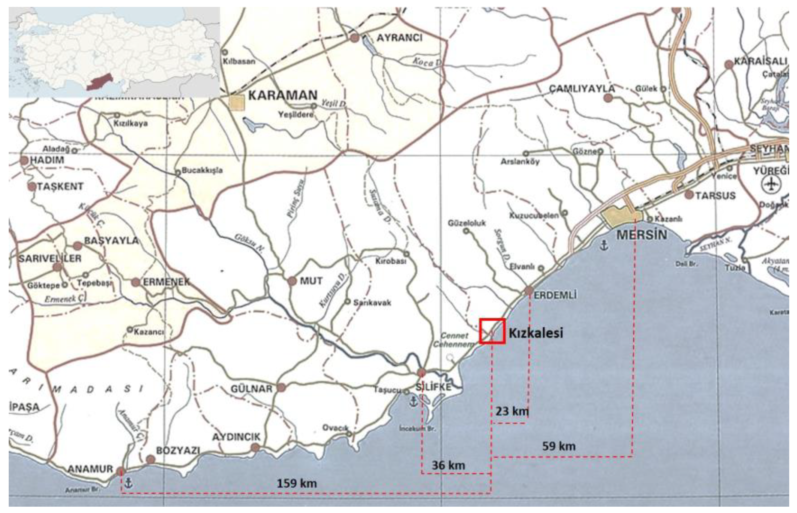
Figure 2.
Kızkalesi neighbourhood and its surrounding. Image from [11] (p. 12).
Figure 2.
Kızkalesi neighbourhood and its surrounding. Image from [11] (p. 12).
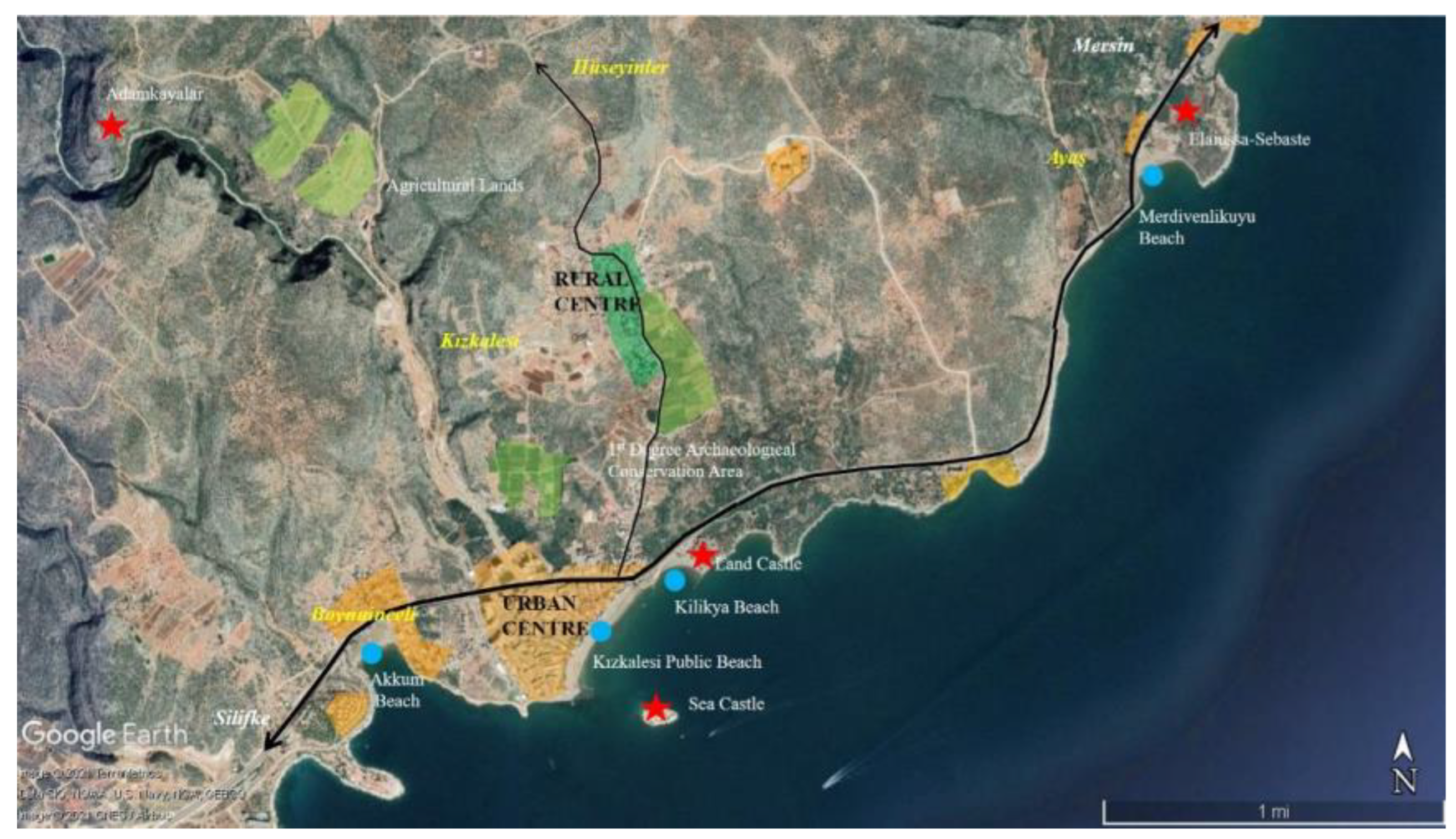
Figure 3.
(a) Kızkalesi land and sea castles; (b) Kızkalesi public beach. Photos from [12].
Figure 3.
(a) Kızkalesi land and sea castles; (b) Kızkalesi public beach. Photos from [12].
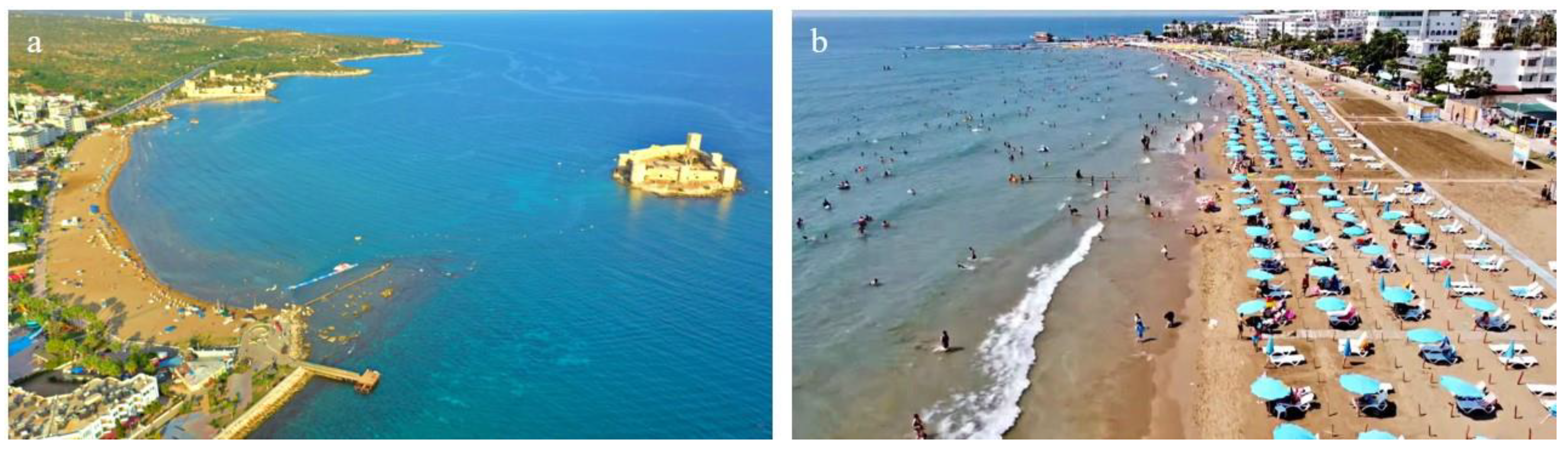
Figure 4.
Aerial photographs of Kızkalesi in the years (a) 1978 and (b)1990. Images from personal archive of Yasemin Sarıkaya Levent.
Figure 4.
Aerial photographs of Kızkalesi in the years (a) 1978 and (b)1990. Images from personal archive of Yasemin Sarıkaya Levent.
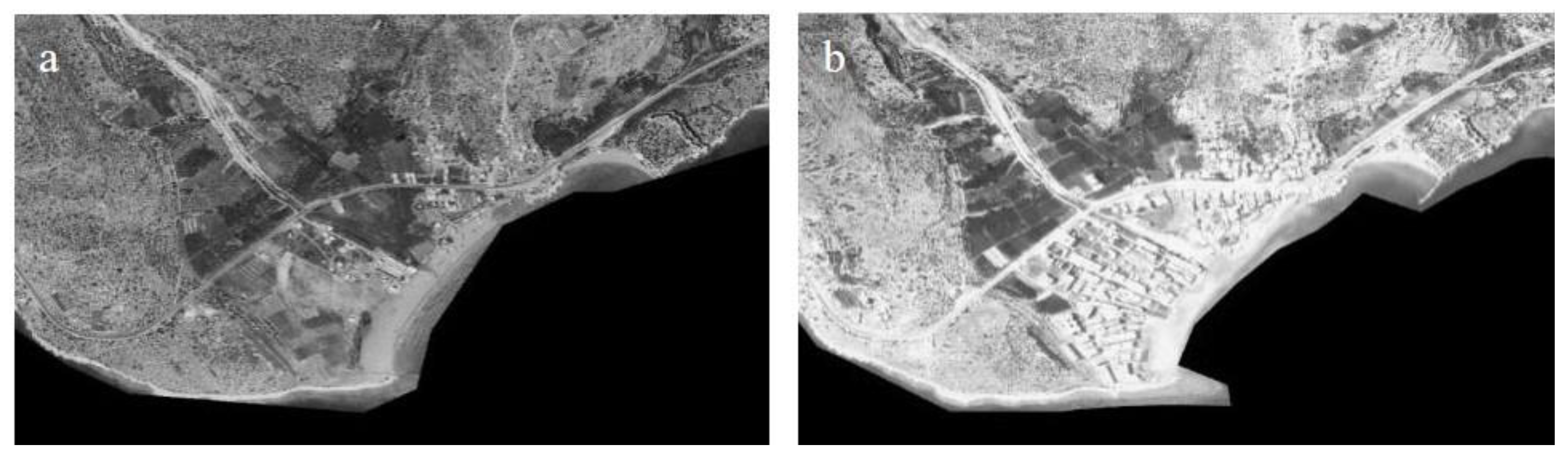
Figure 5.
Research methodology.
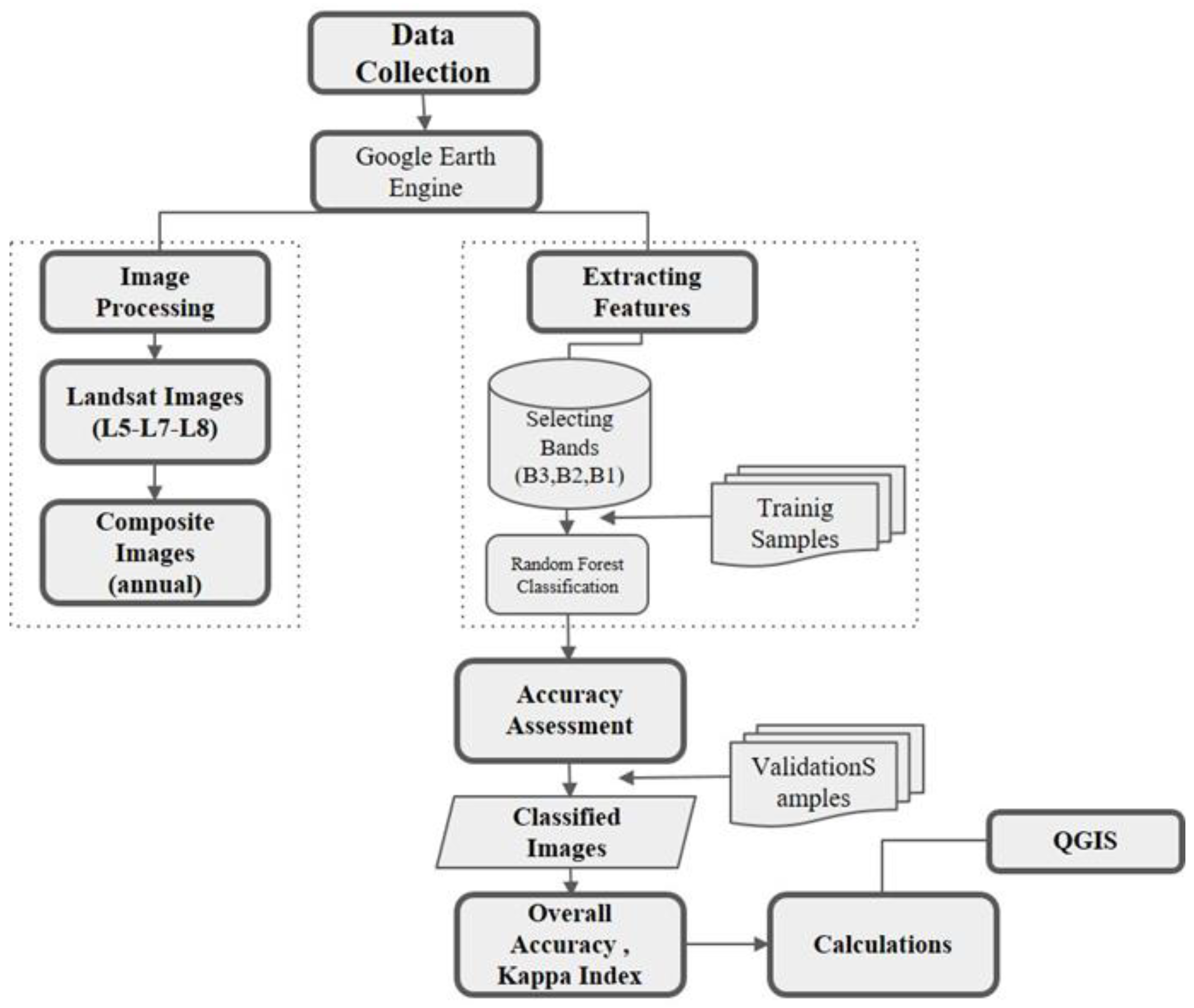
Figure 6.
Satellite images, and LULC classification of the western coastline of Mersin and Kızkalesi.
Figure 6.
Satellite images, and LULC classification of the western coastline of Mersin and Kızkalesi.
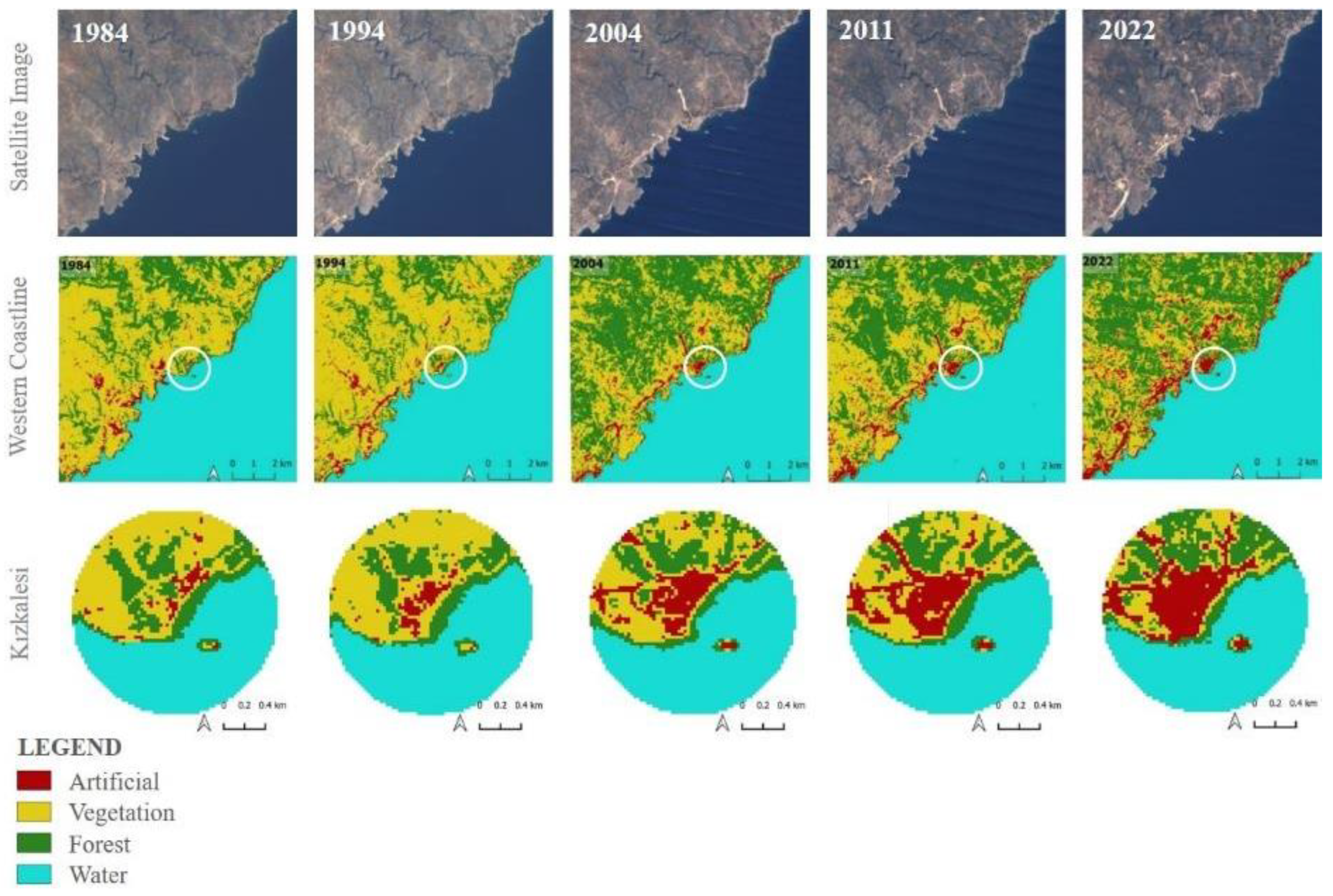
Figure 7.
LULC changes in the western coastline of Mersin and Kızkalesi.
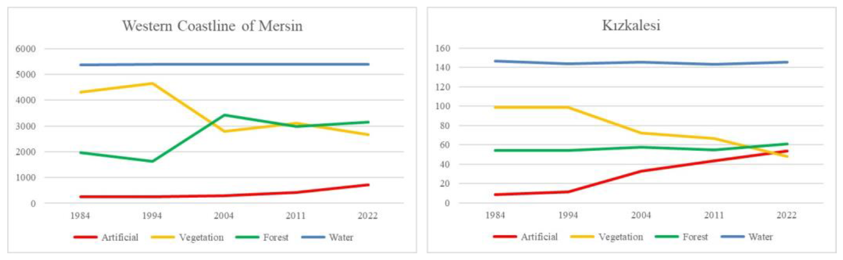
Figure 8.
Population change in Kızkalesi neighbourhood in relation to administrative changes. Prepared by the authors based on data from Turkish Statistical Institute [35]. * Census in 2000 is intentionally not used in the analysis due to its low accuracy [36]. The census data in traditional survey method was lastly collected on 22 October 2000 which could be considered as tourism season for Kızkalesi. Number of residents at that time has been counted high due to the existence of summer house residents at the settlement. Census data collected after the year 2007 is collected digitally, and therefore, more accurate.
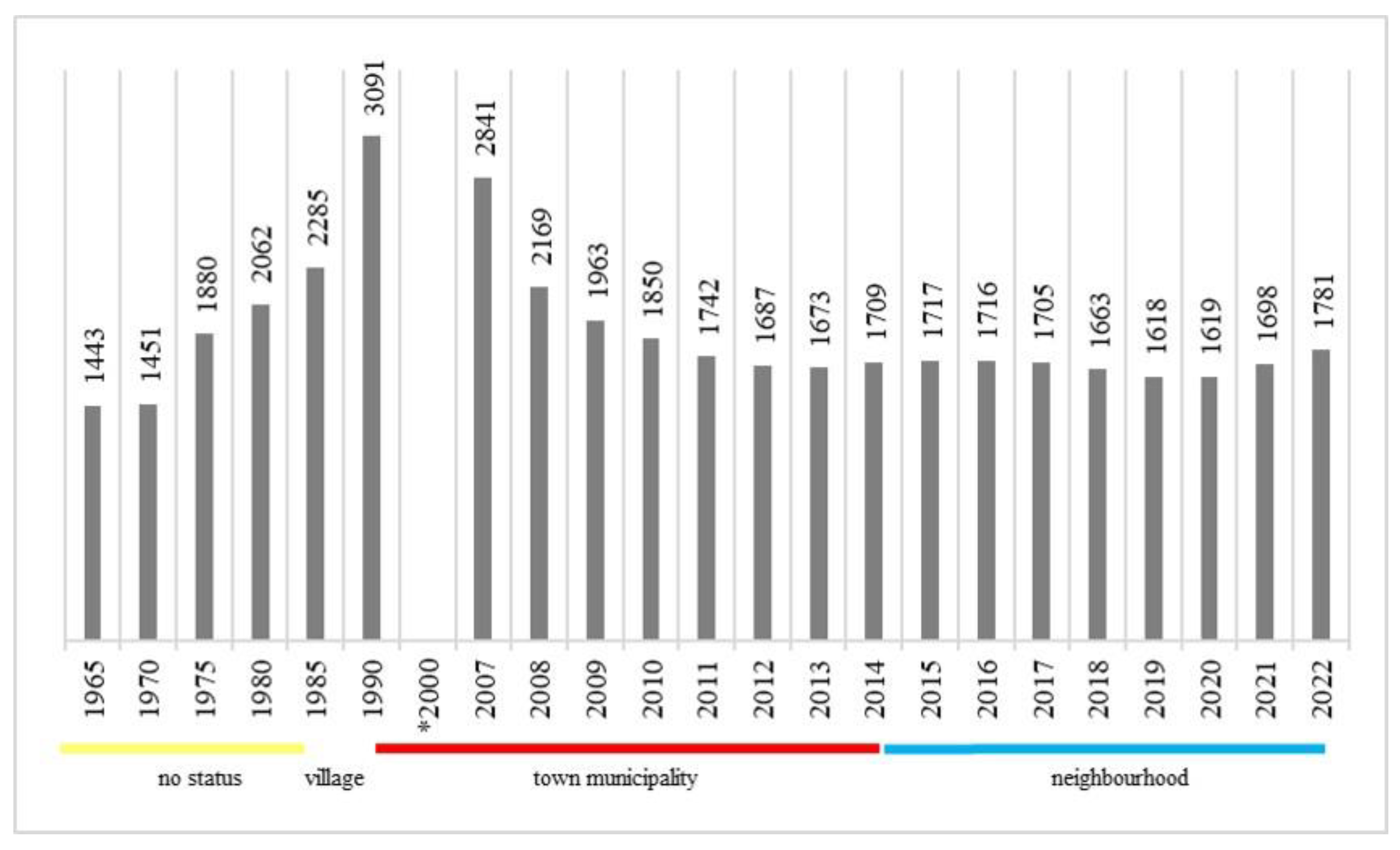
Figure 9.
LULC changes in the western coastline of Mersin in relation with national policies, and regional strategies and plans.
Figure 9.
LULC changes in the western coastline of Mersin in relation with national policies, and regional strategies and plans.
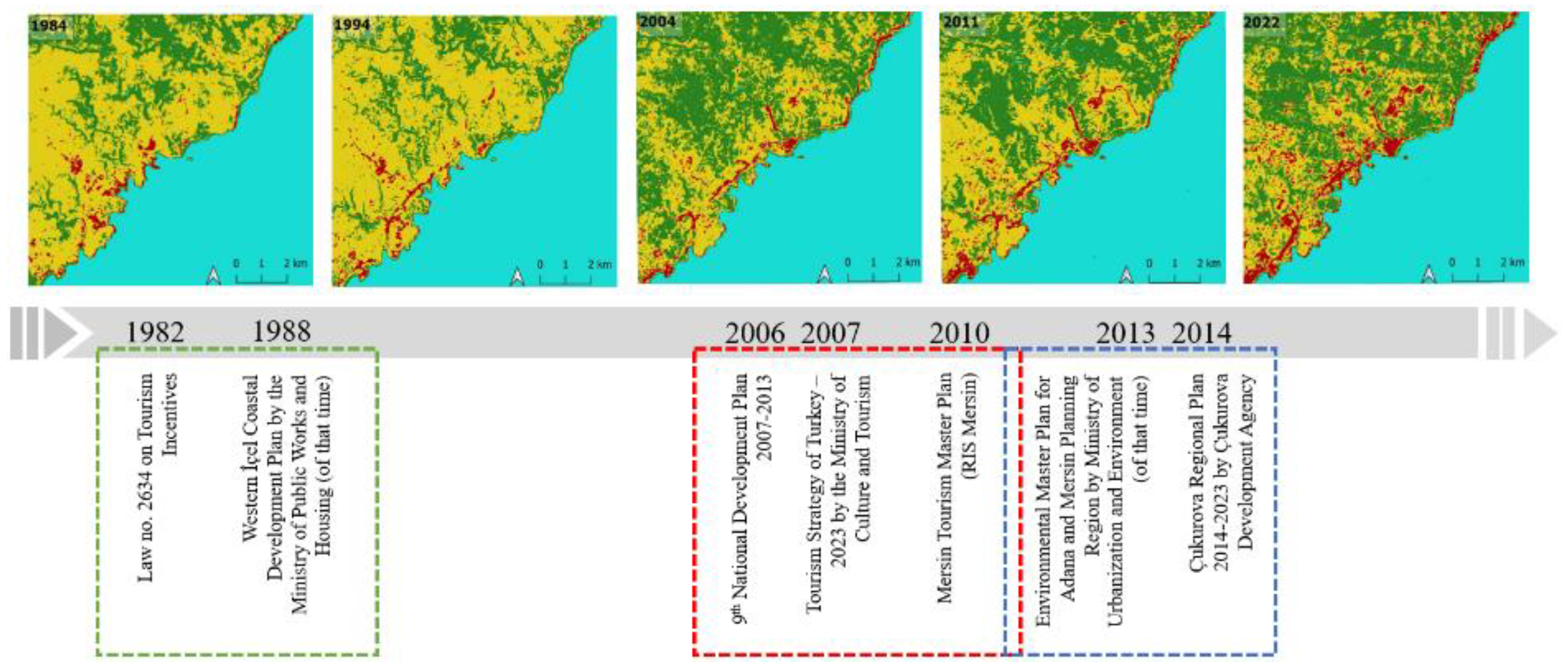
Figure 10.
LULC changes in Kızkalesi in relation with the changes in local administrative system and spatial planning process.
Figure 10.
LULC changes in Kızkalesi in relation with the changes in local administrative system and spatial planning process.
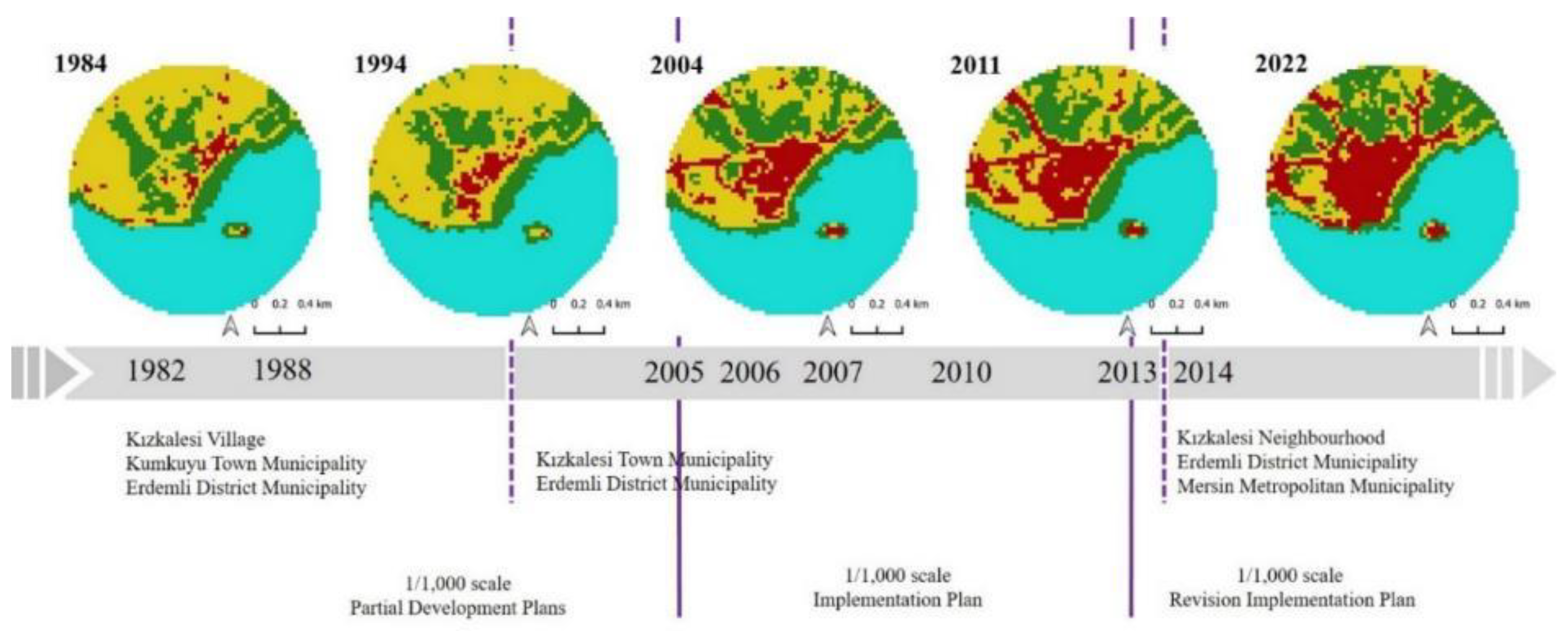
Figure 11.
1/1,000 scale implementation plan of Kızkalesi urban centre approved in 2005. Image from personal archive of Yasemin Sarıkaya Levent.
Figure 11.
1/1,000 scale implementation plan of Kızkalesi urban centre approved in 2005. Image from personal archive of Yasemin Sarıkaya Levent.
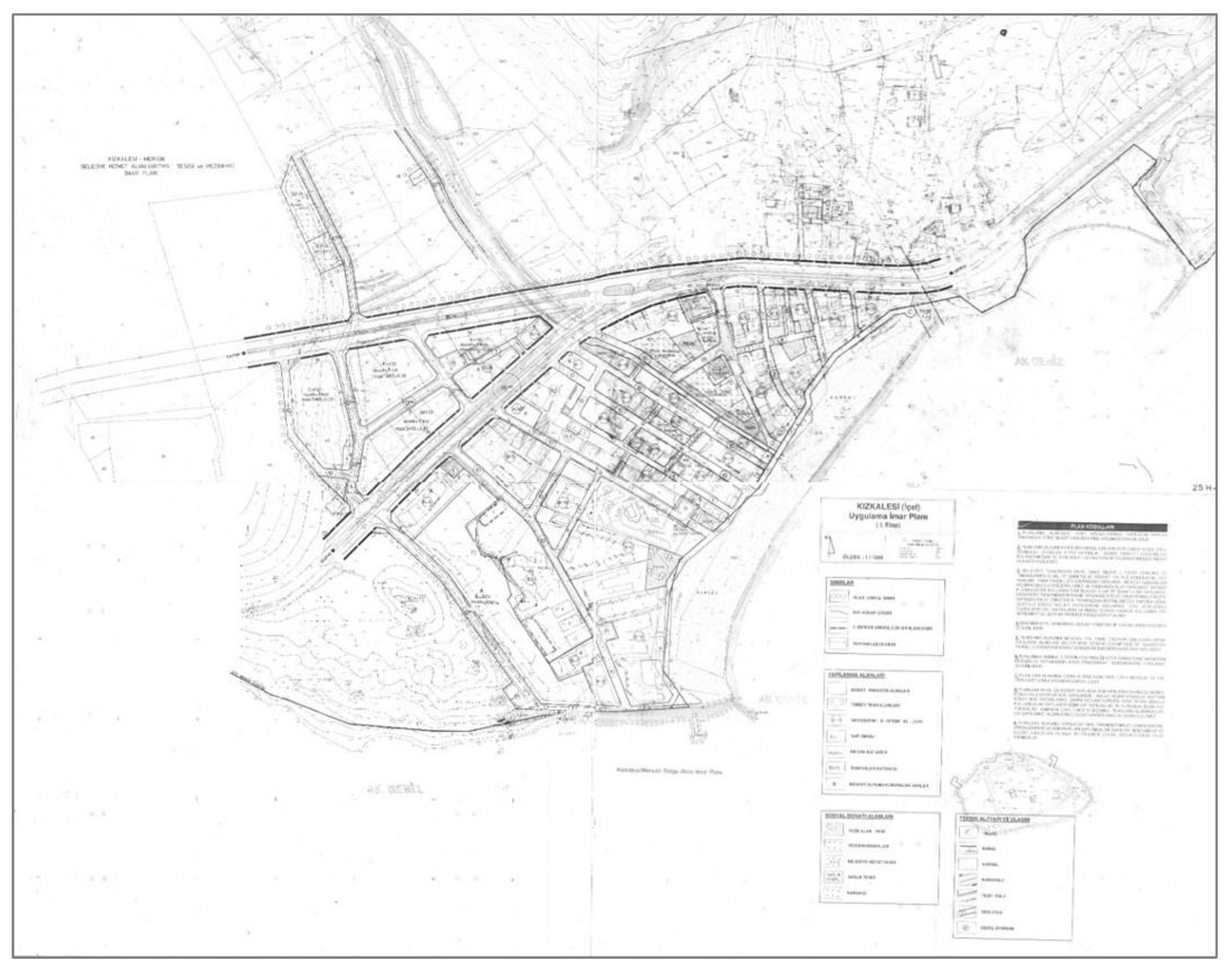
Figure 12.
(a) 1/1,000 scale partial development plan in Kızkalesi, and (b) its application as summer houses 3.2 km north of the urban centre of Kızkalesi along Hüseyinler road. Image (a) from personal archive of Yasemin Sarıkaya Levent, and (b) Satellite Image © GoogleEarth.
Figure 12.
(a) 1/1,000 scale partial development plan in Kızkalesi, and (b) its application as summer houses 3.2 km north of the urban centre of Kızkalesi along Hüseyinler road. Image (a) from personal archive of Yasemin Sarıkaya Levent, and (b) Satellite Image © GoogleEarth.
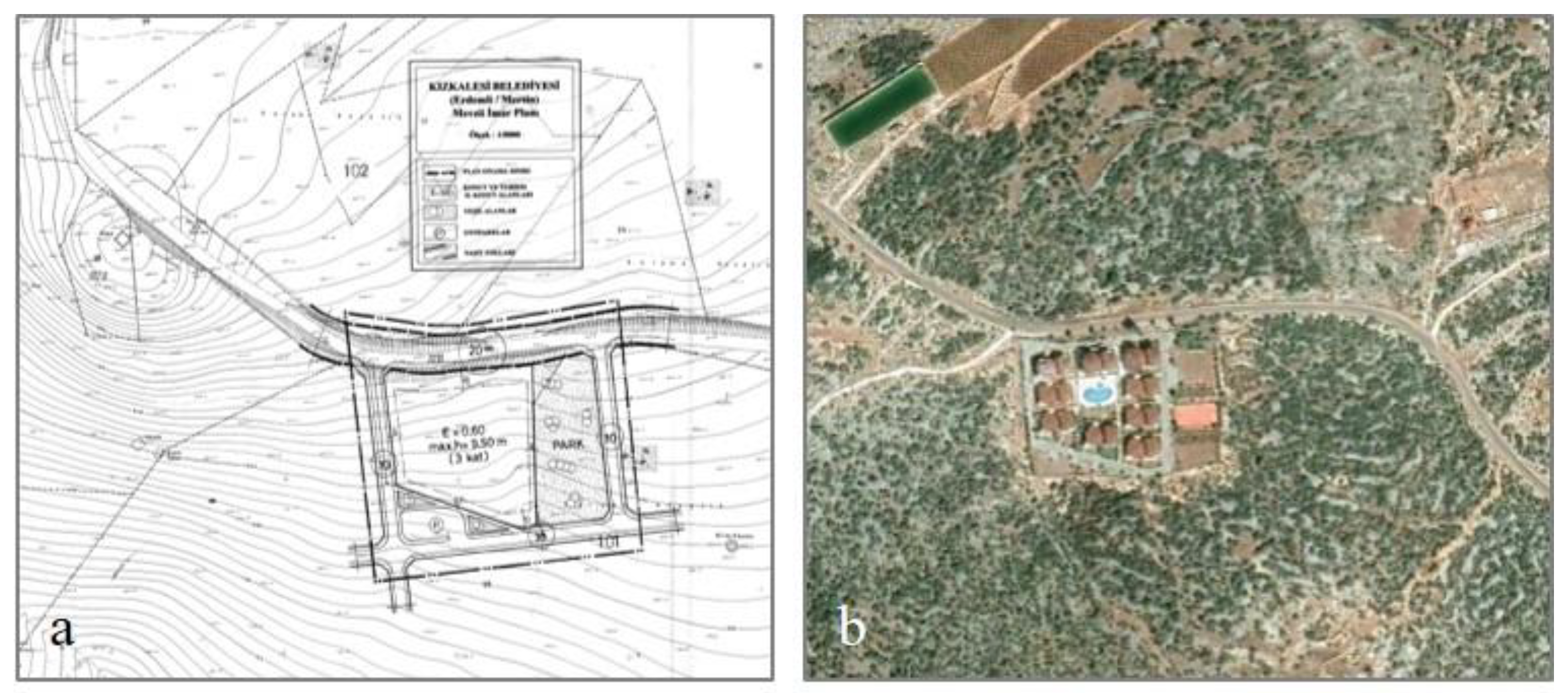
Figure 13.
1/1,000 scale revision implementation plan of Kızkalesi urban centre approved in 2013. Image from Mersin Metropolitan Municipality Archive.
Figure 13.
1/1,000 scale revision implementation plan of Kızkalesi urban centre approved in 2013. Image from Mersin Metropolitan Municipality Archive.
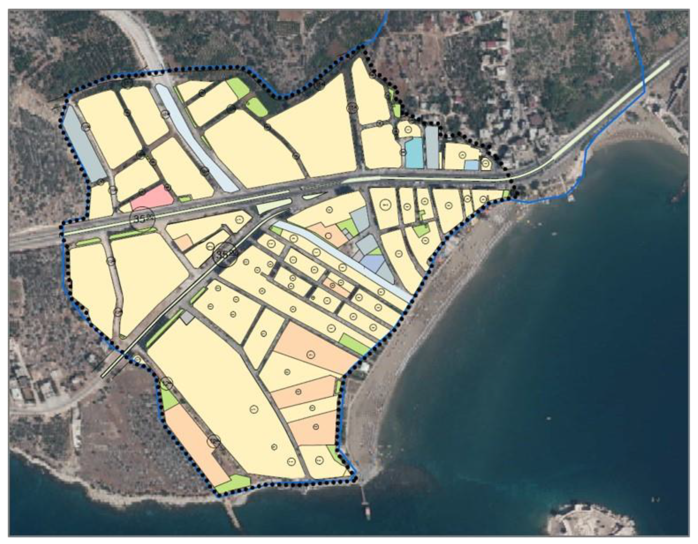
Figure 14.
The relation of the national policies, regional strategies, and spatial plans in Kızkalesi.
Figure 14.
The relation of the national policies, regional strategies, and spatial plans in Kızkalesi.
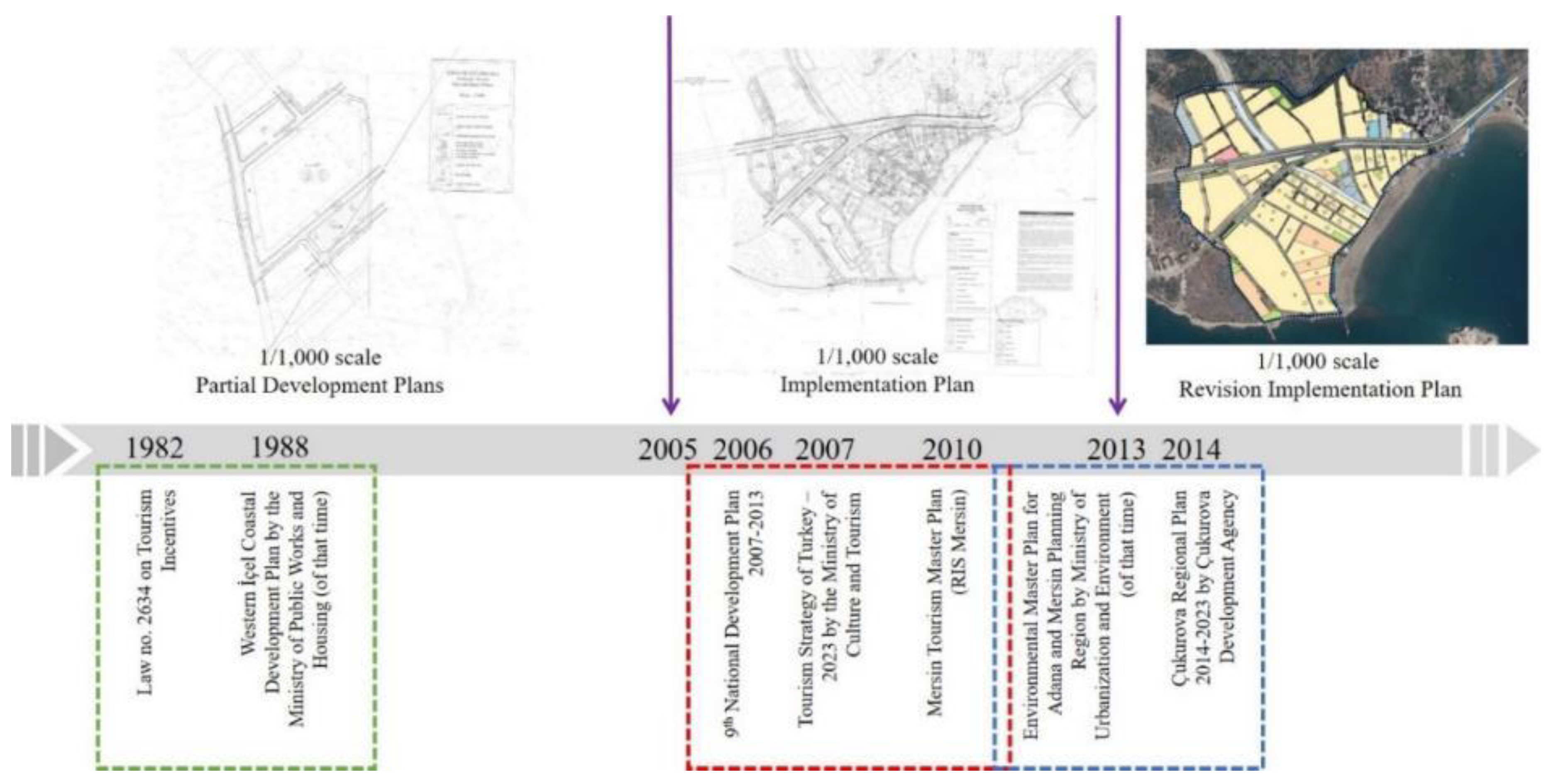
Figure 15.
Significance in LULC changes in Kızkalesi.
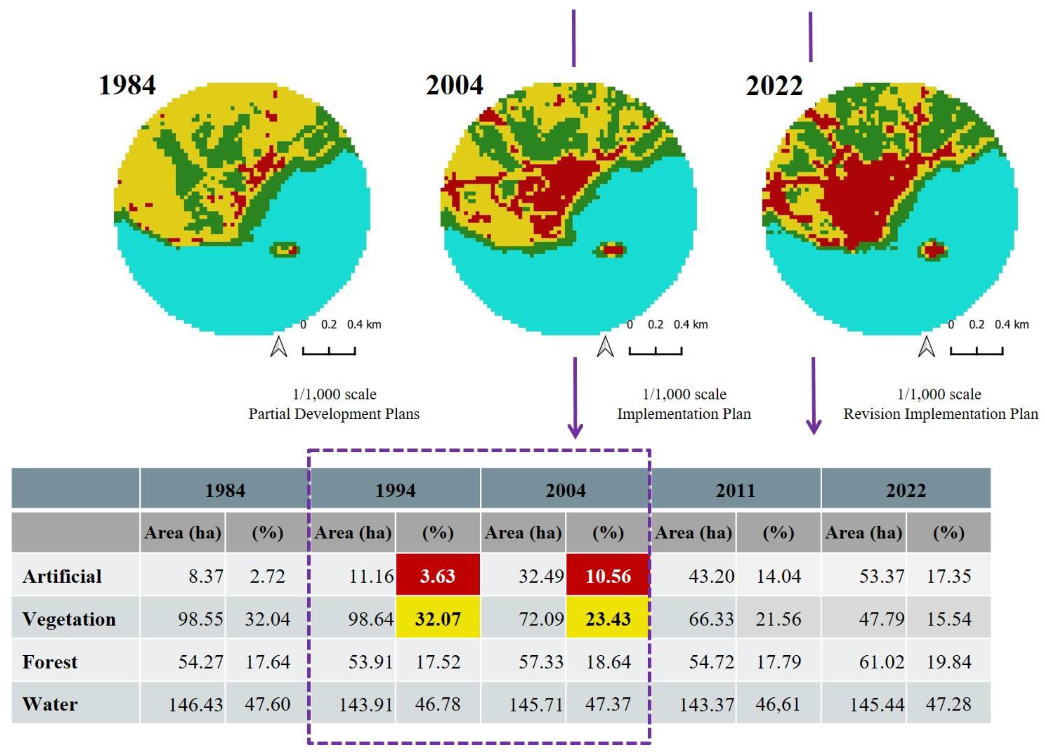
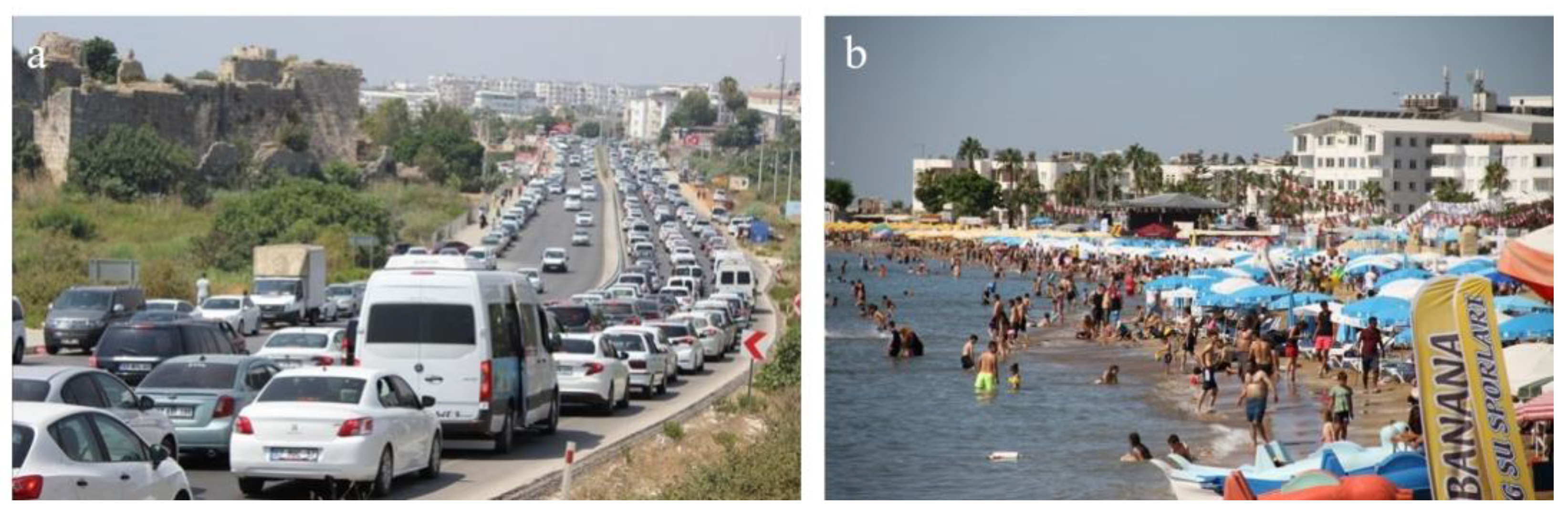
Table 1.
Statistics of tourism facilities in Kızkalesi during the 1990s and 2020s.
| Kızkalesi Tourism Facilities |
1990s | 2020s | ||
|---|---|---|---|---|
| Number | Bed capacity | Number | Bed capacity | |
| Hotel | 14 | 615 | 104 | 4,750 |
| Motel | 18 | 430 | ||
| Pension | 38 | 1,740 | ||
| Camping area | 2 | 200 | ||
| Summer house | 856 | 3,424 | 1,814 | 7,256 |
| Total | 928 | 6,409 | 1,918 | 12,006 |
* Prepared by the authors based on data obtained from [13], and Kızkalesi Culture and Tourism Association in 2021.
Table 2.
Satellite images and accuracy values for years.
| Satellite Image | Year | Overall Accuracy | Kappa Coefficient |
|---|---|---|---|
| Landsat 5 TM | 1994 | 0.85 | 0.81 |
| Landsat 7 ETM+ | 2004 | 0.82 | 0.81 |
| Landsat 7 ETM+ | 2011 | 0.96 | 0.95 |
| Landsat 8 OLI/TIRS | 2022 | 0.90 | 0.88 |
Table 3.
LULC changes in the western coastline of Mersin.
| 1984 | 1994 | 2004 | 2011 | 2022 | ||||||
|---|---|---|---|---|---|---|---|---|---|---|
| Area (ha) | (%) | Area (ha) | (%) | Area (ha) | (%) | Area (ha) | (%) | Area (ha) | (%) | |
| Artificial | 246.42 | 2.07 | 247.68 | 2.08 | 295.47 | 2.48 | 428.31 | 3.60 | 708.57 | 5.95 |
| Vegetation | 4321.44 | 36.27 | 4659.12 | 39.11 | 2799.09 | 23.49 | 3108.87 | 26.09 | 2659.59 | 22.32 |
| Forest | 1974.51 | 16.57 | 1622.79 | 13.62 | 3426.21 | 28.76 | 2980.98 | 25.02 | 3154.86 | 26.48 |
| Water | 5371.38 | 45.09 | 5384.16 | 45.19 | 5392.98 | 45.27 | 5395.59 | 45.29 | 5390.73 | 45.25 |
Table 4.
LULC changes in Kızkalesi.
| 1984 | 1994 | 2004 | 2011 | 2022 | ||||||
|---|---|---|---|---|---|---|---|---|---|---|
| Area (ha) | (%) | Area (ha) | (%) | Area (ha) | (%) | Area (ha) | (%) | Area (ha) | (%) | |
| Artificial | 8.37 | 2.72 | 11.16 | 3.63 | 32.49 | 10.56 | 43.20 | 14.04 | 53.37 | 17.35 |
| Vegetation | 98,55 | 32,04 | 98,64 | 32.07 | 72,09 | 23.43 | 66.33 | 21.56 | 47.79 | 15.54 |
| Forest | 54.27 | 17.64 | 53.91 | 17.52 | 57.33 | 18.64 | 54.72 | 17.79 | 61.02 | 19.84 |
| Water | 146.43 | 47.60 | 143.91 | 46.78 | 145.71 | 47.37 | 143.37 | 46.61 | 145.44 | 47.28 |
Disclaimer/Publisher’s Note: The statements, opinions and data contained in all publications are solely those of the individual author(s) and contributor(s) and not of MDPI and/or the editor(s). MDPI and/or the editor(s) disclaim responsibility for any injury to people or property resulting from any ideas, methods, instructions or products referred to in the content. |
© 2023 by the authors. Licensee MDPI, Basel, Switzerland. This article is an open access article distributed under the terms and conditions of the Creative Commons Attribution (CC BY) license (http://creativecommons.org/licenses/by/4.0/).
Copyright: This open access article is published under a Creative Commons CC BY 4.0 license, which permit the free download, distribution, and reuse, provided that the author and preprint are cited in any reuse.


