
Submitted:
21 November 2023
Posted:
21 November 2023
You are already at the latest version
Abstract
Australia is a unique continent surrounded by the ocean and the majority of catchments flow to the coast. Some of these catchments are gauged and others are ungauged. There are 405 gauged catchments covering 2,549,000 km2 across the coastal regions of 12 drainage divisions in Australia. Whereas there are 771 catchments conceptualised as ungauged covering additional 835,000 km2. The mean annual rainfall and PET and its spatial and temporal distribution vary significantly from one drainage division to another. We developed a continuous daily streamflow time series of all gauged and ungauged catchments from 1993 onwards. We applied the GR4J lumped conceptual model to these catchments. The performance of gauged catchments was analysed through (i) visual inspection of daily hydrographs, flow duration curves and daily scatter plots, and (ii) performance metrics including NSE and PBias. Based on the NSE and PBias, performance ratings of 80% and 96% of the models respectively were found 'good'. There was no relationship found between the catchment area and model performance. The ungauged catchments were divided into four categories based on distance from potential donor catchments where observed data are available for GR4J model calibration, and Köppen climate zone. The total ungauged catchments represent 24.7% of the total drainage division areas. The streamflow from ungauged catchments was estimated using GR4J model based on the parameters of their donor catchments. Overall, runoff ratios from ungauged catchments were found to be higher compared to their donor gauged catchments, likely driven by their higher rainfall and less PET. This tendency was particularly evident in two drainage divisions – the Carpentaria Coast (CC) and Tanami-Timor Sea Coast (TTS) where ungauged areas comprised 51% and 43% respectively. The mean gauged annual streamflow varied significantly across drainage divisions – 230 GL from South Australian Gulf (SAG) to 146,150 GL in TTS. The streamflow from all ungauged catchments was estimated at 232,200 GL per year. Overall, the average streamflow from all drainage divisions, including gauged and ungauged areas, across the coastal regions of Australia was estimated at 419,950 GL per year. This nationwide estimate of streamflow dataset could potentially enhance our understanding of coastal processes and improvements of marine modelling systems and tools.
Keywords:
GR4J model
; coastal discharge estimates
; ungauged catchments
; streamflow simulations
; inverse distance squared method
; Australia
1. Introduction
Water is an integral part of life and impacts directly on most aspects of humans and the environment. Catchments that supply this water integrate changes due to human activities and natural processes. Understanding river discharge is an important underpinning water management decisions [1]. Streamflow gauges are the principal means of data collection and have been used for centuries. With the Nilometer as a prime example, stream discharge records are vitally important and without these records, we cannot understand, observe and manage our hydrologic systems for human development. It is the most accurately measured component of the hydrological cycle[2].
As the streamflow measurement gauges can be built only at the finite locations in the stream network, they can only provide limited information in space-time continuum [2]. The establishment and operations of the streamflow measurement gauges are costly and therefore their location and operations largely depend upon the national or local interests or funding from particular projects [3]. Even if the resources are available, it is not practically possible to build and operate flow measurement gauging stations at every possible location of the stream network. As a result, streamflow is only monitored in a small fraction of rivers in the world and most catchments remain completely ungauged [4,5,6]. This is a common problem prevalent in developed and developing nations – for example, USA [3], UK [7], Canada (Environment and Climate Change Canada:https://wateroffice.ec.gc.ca/mainmenu/historical_data_index_e.html, accessed 2November 2023), Asia [8] and Africa [9]. In Australia, Its Indigenous peoples have over 65,000 years of connection and understanding of water and the value of water is central to their culture [10]. However, streamflow monitoring with gauges formally started as early as 1865 and expanded continuously till 1965. Since then, the monitoring network slightly declined [11]. Most of these streamflow measurement gauging stations are located in high-value water resource catchments, mainly in the coastal regions of Australia.
Australia is a marine nation and uniquely placed on the planet. Its marine state surrounds the entire continent, covers about 14 million km2 and has a strong impact on terrestrial climates [12]. Its mainland coastline is approximately 38,910 km long [13] and has the third largest marine jurisdiction in the world – diverse and ranges from the tropics to the sub-Antarctic. Marine industries currently contribute over $47 billion to Australia’s economy [12]. The Australian Government’s National Marine Science Plan 2015–2025 highlighted challenges and emphasizes the need to develop and refine decision-support tools that translate knowledge and data into useful information for effective decision-making in relation to these challenges. It also identifies the need for a coordinated national marine environment and socioeconomic modelling system. In response to these challenges, the Integrated Marine Observing System (IMOS) was established and a large number of marine modelling systems were developed for research and implementation of the strategy [14,15]. For the further enhancement, accuracy and efficient operations of these modelling systems, a nationwide quality-controlled stream discharge data set of the major rivers flowing to the coastal regions of Australia will be highly beneficial, as it could be taken as dynamic input to these systems. The nationwide coastal streamflow data set will also be useful for ocean-climate science research, model development, retrospective analyses, nowcasting and forecasting.
Most of the river systems in Australia discharge into the coastal regions. There are only a limited number of gauging stations recording the discharge and most of the rivers are ungauged (Figure 1). Without a consistent and comprehensive nation-wide record of streamflow dataset, we are unable to improve our understanding of coastal processes and improve our marine modelling systems and tools. Therefore, the extension of the existing streamflow records and estimation of ungauged streamflow is vital for creating a complete nationwide data set. There are different procedures for estimating ungauged streamflow as detailed in Section 4.3. In this study, we used a spatial proximity approach, with the following key objectives:
- Apply GR4J [16] daily rainfall-runoff models at all the coastal gauged catchments and evaluate their performance;
- Identify, cluster and classify ungauged catchments into different categories;
- Transfer and apply GR4J models to all ungauged catchments, and assess performance;
- Estimate daily and annual streamflow and create a nationwide coastal streamflow data set for all gauged and ungauged catchments.
2. Australia's Coastal Regions
More than 80% of Australians live within the coastal regions [7,17]. It includes cities and supports important industries such as agriculture, fisheries, and tourism. A significant number of important environmental, biological and heritage sites are situated within the coastal regions, including wetlands, estuaries, mangroves and coral reefs. Almost all of the major river systems discharge into the coastal regions which enrich environmental assets and supporting the livelihood of most Australians.
2.1. Weather and Climate
Droughts, floods and bushfires are very common in Australia as it is the driest inhabited continent on earth, receiving only 450 mm mean annual rainfall [18]. The rainfall also varies spatially and temporarily across the country, with approximately 70% of the landmass being arid or semi-arid receiving less than 475 mm per year [19]. Australia's climate zones were defined by Köppen Climate Classification [20] and have equatorial, tropical and subtropical regions in the north and temperate regions in the south (Figure A1 in Appendix). The south-east and south-west part of Australia has temperate and the north has tropical climate respectively [20]. The east and south-east coastal regions have mountain ranges. Annual rainfall is higher and more reliable in coastal regions with the exception of mid-west coastal regions of Western Australia (Figure A2 in Appendix). Landscape elevation influences the amount and distribution of rainfall, with mountainous areas such as northeast Queensland, southeast Australia and western Tasmania receiving higher rainfall [21].
Australia's river system was divided into 13 drainage divisions (Figure 1). Rivers in all other drainage divisions discharge into coastal waters and oceans, with the exception of Lake Eyre. The mean annual rainfall of these drainage divisions varies significantly. The mean annual potential evaporation (PE) exceeds the mean annual rainfall except for Tasmania (Figure A2 in Appendix). The water-limited environment [22] generally controls the streamflow generation processes. The within-year distribution pattern of rainfall, streamflow and potential evaporation across different drainage divisions in the coastal regions vary widely. The wet season starts in November-December and ends in March-April in the northern part while in the southern part of the continent, it begins in June-July and ends in December-January respectively.
2.2. Streamflow Measurements
There are approximately 4,800 streamflow gauging stations in Australia [23]. These gauging stations are predominantly located in the catchments which have high economic, environmental, social and cultural significance. At first, we considered all streamflow gauged and ungauged catchments from all 12 drainage divisions draining into the Australian coastline, with the exception of the Lake Eyre drainage division. Our primary focus was on the catchments discharging into the marine environment, which impacts the entire Australian coastline. Most gauging stations are located on the Eastern Coast of Australia, whereas most of the ungauged catchment area resides on the Northern and Southern Coasts of Australia (Figure A3 in Appendix). As our primary objective is to create continuous streamflow data at the coastal river nodes (ungauged catchment outlets), located across Australia, we selected gauges based on:
- Distance from the coast in the catchment to avoid tidal effects and minimising the ungauged area; and
- The availability of data from 1993 onwards with at least 5 years of operational observed streamflow data.
Through this process, we selected a total of 405 most downstream gauged locations from 12 drainage divisions (Figure 1); and other locations which did not meet the above criteria were rejected and categorised as ungauged catchments.
2.3. Developing gauged and ungauged catchments
We considered gauged and ungauged catchments from all 12 drainage divisions draining to the Australian coastline. First, the Geofabric, Australian Hydrological Geospatial Fabric, [24] (Bureau of Meteorology website: http://www.bom.gov.au/water/geofabric/, accessed 24 November 2023) layers were used to delineate all gauged and ungauged catchments. Ungauged catchments were defined as either: (i) the catchments between the most downstream gauging station(s) and the coastline, mainly the tidal zone, with an area greater than 100 km2; and (ii) catchments along the coastline that do not have streamflow gauging stations directly upstream, with an area greater than 100 km2. The ungauged catchments were delineated for all 12 drainage divisions along the coastal regions. We conceptualised the ungauged catchments into four categories (Figure 2):
- Category 1: Ungauged area was downstream of a gauged catchment; or
- Category 2: Ungauged catchments where there were nearby gauged catchments within a radius of up to 50 km; or
- Category 3: Ungauged catchments with at least two neighbouring gauged catchments within a 50 km to 250 km radius and in the same Köppen climate zone (Figure A1 in Appendix); or
- Category 4: Ungauged catchments with only one, or no neighbouring gauged catchments under a 250 km radius; but within the same Köppen climate zone.
All the coastal nodes, gauged and ungauged catchments in all 12 drainage divisions are shown in Figure A3 in Appendix.
3. Data Quality Control and gap Filling
3.1. Data quality control
The observed streamflow data from 405 gauged locations (Figure 1) was sourced from operational Bureau of Meteorology data feeds and directly from the partner organisations. A quality-assurance, quality control process was required and applied to all datasets used; specifically, observation time-series of daily streamflow. The quality-assurance process involved the identification and removal of erroneous data values such as negative, extreme, and long linear interpolation. The process of detection and removal was automated and then checked manually. An example of an erroneous data set is shown in Figure 3. The process includes the following steps and was performed manually for the datasets obtained from all the gauged locations:
- Download the time-series dataset and run QATS (Quality Assurance of Time-Series) tool;
- Manually fill missing values (those unobserved and picked up by the tool) through a gap-filling heuristic;
- Plot the time series to manually scan for errors not flagged through automation; and
- Reapply the above steps until a final dataset is agreed upon.
3. Methodology
In this study our main objective was to generate the continuous, simulated streamflow time series for gauged and ungauged catchments across the entire coast of Australia using the GR4J hydrologic model, as detailed in Figure 4. We also assessed the performance of the model and identified avenues for future research and development.
4.1. Application of GR4J model to gauged catchments
The GR4J is a simple four parameters daily rainfall-runoff model [16]. A schematic of the model is presented in Figure A4 in Appendix. It has been included in the Bureau of Meteorology's Short-term Water Information Forecasting Tools (SWIFT) (Perraud et al., 2015). Research conducted in Australia [16,26,27,28,29,30] demonstrate that GR4J and its hourly variant (GR4H) perform well in the Australian context. Therefore, we have chosen and applied the GR4J rainfall-runoff model to all gauged catchments. The Australian Hydrological Geospatial Fabric (Geofabric) [24] has a nationally consistent flow direction map. We used Geofabric to delineate each catchment. The fundamental hydrologic model is applied to each catchment. The model was calibrated for each catchment using the Shuffle Complex Evolution-University of Arizona (SCE-UA) algorithm [31].
Some of the 405 catchments have regulated structures including dams, weirs and water storages. For simplicity, we did not include water balance modelling of water storage inflow, release, spill, draw, diversion, return flow and evaporation.
4.1.1. Input data preparation
The model was developed without a priori knowledge of the rainfall-runoff transformation, with two inputs to the model: (i) areal average daily rainfall and (ii) daily potential evapotranspiration (PET), both obtained from Australian Water Availability Project (AWAP)[32]. Daily rainfall and potential evapotranspiration data are available at a 5 km by 5 km grid across Australia. The PET data are calculated using Priestley-Taylor evaporation equation [33]. The average areal observed rainfall and PET for each catchment are calculated by averaging the value of grids (5 km by 5 km) within the catchment. The discharge data for all 405 gauging stations were prepared and quality checked as detailed in Section 3.1.
4.1.2. Objective function for model calibration
The SWIFT modelling suite has inbuilt objective functions that include Nash-Sutcliffe Efficiency (NSE) and Kling-Gupta Efficiency (KGE) [34]. In this application we used NSE and KGE separately for model GR4J model calibration and presented NSE results for brevity. Additionally we used diagnostic plots, which provide visual images and empirical understanding of calibrated time series [35,36]. All the model parameters were automatically calibrated using the Shuffle Complex Evolution-University of Arizona (SCE-UA) algorithm [31]. First three years of observed streamflow data were used for model 'warm up' period.
4.2. Gap Filling
The gap filling of the observed discharge datasets was completed through the: (i) application of the GR4J model [16]; or (ii) adoption of an interpolation technique considered most suitable. A gap may constitute missing data, discard erroneous data or constant value or otherwise be picked up by running the automated quality-assurance procedure and by means of manual inspection. If the gap was greater than 5 days, we used the GR4J simulation time series with a simple error correction to fill it. However, if the gap was less than or equal to 5 days, we adopted a three-step procedure in filling these gaps:
- A linear interpolation was applied where the leading or rising trend of the hydrograph appeared to be constant and little change occurred in hydrometeorological information of rainfall and or Potential Evapotranspiration (PET).
- The GR4J model was applied where a noticeable change appeared in the leading or rising trend of the hydrograph alongside backing evidence of a variation in hydrometeorological information of rainfall and or PET.
- In the case that a linear trend or otherwise was apparent, the gap was checked against the hydrological model simulations for the relevant durations and where the trend was constant or where no noticeable event was simulated by the model, linear interpolation technique was adopted or otherwise kept unchanged.
4.3. Estimation of Ungauged Streamflow
There are plenty of literature on estimating ungauged streamflow. Following decades of research in ungauged basins [6], a few comprehensive reviews of the procedure of estimating ungauged streamflow have been completed: (i) the regionalisation of streamflow, model parameter optimisation and uncertainty [37], (ii) rainfall-runoff modelling through identifying hydrological similarity and transposing parameters from gauged to ungauged catchments [38], and (iii) challenges ahead for cold ungauged regions across the globe [39]. These reviews demonstrate that numerous approaches had already been developed for simulating streamflow time series in ungauged catchments, and rainfall runoff modelling plays a major role [40]. It has been widely used for predicting streamflow times series in ungauged catchments in Europe [40], the U.S.A. [41,42], Australia [43,44], Canada [39], South America [45], Africa [39,46], and Asia [38,44,47,48].
Various methods have been used in transferring calibrated rainfall runoff model parameters obtained from gauged to ungauged catchments. There are many studies which have used the entire set of calibrated parameter values from a donor catchment to simulate streamflow of a targeted ungauged catchment. The donor catchment is generally selected based on: (i) physical features, similarities and or (ii) spatial proximity to the targeted ungauged catchment. It has been demonstrated that the geographically closest catchment (or spatial proximity) to the target ungauged catchment is often the best donor catchment [6,43,49,50,51,52]. The parameter regression method has also been used to transfer parameters to ungauged catchments, with the presumption that the calibrated parameters represent catchment attributes (e.g., slope, elevation, drainage density, land use, soil type). In this method empirical relationships between catchment attributes are obtained and that are used to estimate model parameters in ungauged catchments [40,51,53]. Comparison studies show that spatial proximity performs better than the parameter regression method for regions with dense networks of gauging stations [54,55,56].
In this study, we have used the spatial proximity method in selecting the donor catchments (where the GR4J model was calibrated) to obtain the parameters of the targeted ungauged catchments. At first, we calibrated and applied the GR4J model at all 405 gauged catchments across Australia. To obtain parameters for the ungauged catchments, we conceptualised them into three different categories as depicted in Figure 4. Then we estimated model parameters sets and applied the GR4J model to each of the ungauged catchments using each of the parameter sets with estimated sub-areal rainfall and PET as detailed in the following section. For Category 2-4 ungauged catchments, inverse distance-weightings were applied for final streamflow estimate.
A GR4J parameter transfer method was applied to those catchments in Category 1. The gauged runoff from one or more upstream gauged catchments was routed to the ungauged point and accumulated with the ungauged estimate at a chosen end of the system coastal node (Figure 2a) in the ungauged area. A warmup period of 3 years from 1990-1993 was applied as part of the modelling procedure. The accumulated output was converted to a discharge time-series, reported at the coastal node.
For the Category 1 ungauged catchment, discharge is estimated by:
Where:
was the gap-filled observed discharge time-series from the gauged locations upstream of an ungauged node on the same river or tributary (Figure 2a), and
was the simulated discharge from the intermediate area using parameters from the upstream gauge on the same river as the coastal node.
The daily streamflow time-series for ungauged catchments in Category 2, were generated through the parameter transfer of neighboring catchments (Figure 2b). is the number of gauged catchments (up to 10) falling inside a maximum Haversine distance [57] of 50 km from the ungauged catchment in question. The discharges from close-by catchments satisfying the aforementioned conditions were calculated through the application of the GR4J model. The parameters generated from the gauged catchments are used with the PET and rainfall climate data to generate the discharges for the ungauged catchments. Finally, the time-series from this category of catchments was estimated at the coastal node, through the inverse-distance weighting of the time-series. The ungauged area discharge is estimated by:
Where:
and ;
was the indicator function, such that if the distance is more than km, then the time-series is not used to estimate the discharge; and
was an inverse distance weighting of power , such that simulated discharge from closer sites receives a larger weighting than those further away.
For each of the ungauged catchments in Category 3, the two nearest gauged catchments where GR4J models were applied for gap filling were selected, such that gauged catchments were within a Haversine distance of 50 km to 250 km of the ungauged area in the same Köppen climate region. The generation of the final estimated time-series at the coastal node was identical to Category 2. Parameters from the two selected gauged catchments and climate data from the ungauged catchment were used to generate two discharge time-series. Finally, a continuous daily discharge for this category of catchments was estimated through inverse-distance-weighting of the two simulated time-series. The ungauged area discharge is estimated by:
Where:
and ; and
50.
This was a simplified version of Category 2 with . Where the Haversine distance between the closest two gauged catchments in the same Köppen climate region (Figure A1 in Appendix) and the ungauged catchment was greater than 250 km, the ungauged catchment was placed in Category 4. The same method outlined in Category 3 was used to estimate discharge from these catchments. The ungauged area discharge is estimated by:
Where:
; or
.
For each of the categories above, the daily discharge was aggregated to annual and compared between different drainage divisions. It is crucial to mention that the estimated daily discharge data should be used prudently, given the underlying uncertainty of the estimated daily data.
4.4. Evaluation Criteria
We have chosen a number of verification metrics and diagnostic plots in evaluating the GR4J model performance, as detailed in the following sections.
4.4.1. Evaluation metrics
There are many goodness-of-fit criteria for hydrological model calibration and performance assessment [58]. For the performance evaluation of the GR4J model at all observed streamflow locations, we used Nash-Sutcliffe Efficiency [59] and the percent bias (PBias) as presented in Table 1. We also used the Coefficient of Determination (R2) between the calibrated and observed streamflow time series for gauge locations selected for diagnostic plots. Moriasi et al. [60] and Chiew and McMahon [61] recommended that a model performance is considered satisfactory when the is greater than 0.5 and the PBIAS ranges are less than ±25% for monthly streamflow. However, values lower than 0.5 for daily streamflow can still be considered satisfactory. Therefore, some of the constraints for the recommended statistics can be relaxed for daily streamflow.
4.4.2. Evaluation diagnostic plots
Diagnostic plots generally provide visual images of the model performance metrics and also provide empirical understandings of model calibrated time series [35,36]. We have chosen three popular diagnostic plots, i.e., times series, flow-duration and correlation scatter plots for the evaluation of model performance (Table 2).
4.4.3. Model performance ratings
In this study, we used the model evaluation metrics NSE and PBias statistics for the daily streamflow for the gauged catchments. These metrics were used by Kalin et al [62] and Yilmaz and Onoz [47] and Chen et al. [63]. Based on these two metrics, model performance on daily streamflow is characterised as 'Very good', 'Good', 'Satisfactory' and 'Unsatisfactory' (Table 3).
5. Results and Discussions
5.1. Gauged and Ungauged Catchments
The total gauged catchment area comprises 405 stations across the coastal regions of Australia and has an area of 2,549,000 km2 (Table 4). A number of catchments where gauged streamflow data presented water balancing issues, mainly due to return flows and diversions, were excluded from the estimation. There was a total of 771 ungauged catchments, categorised as: Category 1 (183 catchments), Category 2 (212 catchments), Category 3 (228 catchments), and Category 4 (148 catchments). The number of ungauged catchments and their areas of different categories varied from one drainage division to another (Table 4). The CC drainage division has the largest ungauged catchment area. The total ungauged catchments have an area of 835,000 km2 and represent 24.7% of the total drainage division areas. The TTS and CC drainage divisions have the largest ungauged area. Maps of gauged and ungauged catchments in each of the drainage divisions are shown in Figure 1 and detailed in Figure A3 in Appendix.
5.2. Model Calibration
We applied the daily G4R4J model to all gauged catchments for the period 1993 onwards. The daily discharge from one drainage division to another varies significantly due to catchment landscape attributes, within year distribution of rainfall and PET [23,30]. We present observed and simulated daily streamflow hydrographs and flow-duration curves of three catchments, located in the TAS, SWC and SAG drainage divisions (Figure 5). In some instances, simulated high flows were earlier or later compared to the observed streamflow. These catchments present a balanced view of the model performance as defined in Table 2. The simulated daily streamflow, high and medium range, generally matched well with the observed streamflow. However, the low flow is generally over predicted as it is evident in the flow duration curves (Figure 5). This may be explained by: (i) over simplification of process representation by conceptualising it as one system irrespective of the catchment area, (ii) inability to represent spatial variability of rainfall, PET and catchment attributes, and (iii) absence of channel routing.
We also present the scatter plots of simulated and observed daily streamflow – one from each of the drainage divisions (Figure 6). As with the daily hydrographs (Figure 5), these catchments present a balanced view of the model performance. In some cases, the simulated high flows were lower than the observed, or timing was earlier or later, which resulted in 'Unsatisfactory' NSE (Table 3).
The model calibration results, NSE and PBias, for all gauged catchments in each of the drainage divisions are presented in Figure 7. The model calibration is rated as 'Very good' for 57% and 88% of the catchments based on NSE and PBias respectively (Table 3). However, the range of these two metrics varied significantly for different catchments within and between the drainage divisions (Figure 7). The MDB, SAG and PG drainage divisions had the highest range of NSE – from 0.05 to 0.95, but the PBias was lower. The NEC drainage division had a higher range of NSE and PBias distribution (Figure 7). The model calibration could be improved by dividing the large catchments into smaller sub-catchments as it was evidenced through the application of the GR4J model for operational 7-day streamflow forecasting service development [64]. Similar results were also found by Viney et al. [65], Zhang and Chiew [43] and Oudin et al. [66] for estimating streamflow from ungauged catchments and selecting donor catchments.
We also investigated the model calibration and performance metrics, NSE and PBias, and their relationship with catchment physical attributes, in particular catchment areas. Our results show no strong relationship exist between catchment areas and both metrics, i.e., NSE and PBias (Figure 8). Similar results were also found by Silberstein et al. [67], when applying a set of lumped catchment models in south-west of Western Australia. However, Sleziak et al. [68] found a positive correlation between increasing NSE and catchment area, when assessing the effectiveness of calibrating conceptual hydrological model in relation to catchment characteristics in Austria. Further research and investigations may reveal the definitive relationship between model performance metrics and catchment areas, in particular Australia.
5.3. Performance Evaluation – Gauged Catchments
We evaluated the performance of the GR4J model based on the evaluation criteria presented in Section 4.4. Visual inspection of diagnostic plots, including daily hydrographs, flow duration curves and scatter plots were completed in evaluating each of the model. A general visual agreement between the observed and simulated streamflow indicates adequate calibration and validation that represent catchment processes and the model's ability to reproduce hydrological behaviors [58]. Most of the models represented the catchment process well, but some were 'Unsatisfactory' as evident through NSE, MAE and PBias metrics. Based on NSE only, 57% of the model performance was rated 'Very good', 23% 'Good', 8% 'Satisfactory' 12% 'Unsatisfactory' respectively. However, according to the PBias metric, 88% of the models were rated as 'Very good', 6% 'Good' and only 3% 'Unsatisfactory' (Table 4). For some catchments, conflicting performance ratings were found – one may be rated 'Very good' or 'Satisfactory' based on the NSE and PBias criteria respectively. At the drainage division scale, it is evident in Figure 7, for example, NSE of different catchments within the PG drainage divisions ranged from 0.03 to 0.95 while PBias was only ±5%. One explanation could be the model's inability to represent spatial variability of rainfall, evaporation, catchment attributes and channel routing and another cause could be the strong influence of high flows on NSE values. Recent application of the GR4J model over 100 catchments across Australia [30,64] demonstrates better performance, including high and low flows, when spatial variabilities and proper channel routing were adopted. Further research may reveal the fundamental causes of these conflicting performance ratings.
5.4. Performance Evaluation – Ungauged Catchments
We assessed the performance of the model in simulating streamflow from ungauged catchments by comparing runoff ratios as the catchment area, flow generation process, PET and rainfall vary significantly across Australia. For a Category 1 ungauged catchment, there was only gauged catchment upstream (Figure 2a). The proportion of the gauged and ungauged catchment areas varied from one catchment to another, due to the unique stream network of the ungauged areas. The proportion of ungauged catchment areas ranged from 1% to 95% among all gauged catchments respectively (Figure 9). However, estimated proportional discharge from ungauged areas was not always similar to the proportion of gauged catchment discharge – mainly due to higher rainfall and lower PET (Figure A2 in Appendix) in the coastal regions compared to inland gauged areas. This feature is also evident in the runoff coefficients of Category 1 catchments across all drainage divisions. Compared to the gauged catchments, estimated runoff coefficient distributions from all categories of ungauged catchments within a drainage division were generally greater (Figure 10). That feature was evident across most of the drainage divisions, with the exception of SEV and SWC.
For the Category 2 ungauged catchments, a maximum of 10 donor catchments were used whereas for the other two categories only two nearest neighbors were considered. Streamflow averaging from multiple donor catchments consistently gives better estimates of ungauged streamflow than the use of single donor catchments. However, enhancement of ungauged streamflow estimates generally diminishes as the number of donor catchments increases [69]. It was found that in Australia, up to 5 donor catchments significantly increase ungauged catchment streamflow estimates [44]. However, in a study using different types of catchments across the world, it was found that the use of up to 10 similar donor catchments enhanced simulated discharge at the ungauged catchments, even substantial improvements were evident if the donor catchments are from similar climate zones greater than 5,000 km away [70]. A comprehensive study using 671 catchments with diverse hydro-climatology, it was found that a 'perfect' donor catchment exists, but not necessarily being the nearest neighbor [51].
The catchment physical similarity approach is another well-known technique used in estimating ungauged streamflow. Application of this approach in Australian catchments may give better outcomes than the nearest neighbor approach [43]. Similar results were also found in Europe and USA [51,54]. An in-depth novel similarity approach was used by Narbondo, et al. [45], where relationships between GR4J parameters and catchment physical attributes were found and then exported to ungauged catchments to estimate streamflow. This approach consistently provided very satisfactory results and could be adopted for estimating ungauged streamflow with highly variable hydro-climatology. In this study, our scope was limited to using nearest neighbor catchments in estimating GR4J model parameters and thereby estimating ungauged streamflow. In the future other approaches should be explored [51] including linking GR4J model parameters with catchment physical properties.
There are several other sources of errors that may shape the estimation of streamflow from ungauged catchments. These include errors in the observed data sets, model structural errors and uncertainty in the regionalisation of model parameter sets. Despite these limitations, hydrological modelling is regarded as the most reliable approach to estimate streamflow from ungauged catchments [6,40].
5.5. Estimated Coastal Discharge
We estimated the mean annual discharge to Australian coastal regions through the application of the GR4J daily model to the gauged and ungauged catchments. The estimated mean annual streamflow varied significantly from one drainage division to another (Table 5). The mean annual discharge from all drainage divisions including the gauged and ungauged catchments was 419,950 GL, with an ungagged catchment contribution of 232,200 GL, representing 55% of the total. Our findings compare well with the National Land and Water Resources Audit [71] estimate of 387,184 GL. The Murray-Darling Basin, Australia's food bowl, has only about 1% catchment area ungauged (Table 3). It is also a very highly managed system, represents 55% of Australia's water use (http://www.bom.gov.au/water/nwa/2020/mdb/regiondescription/geographicinformation.shtml, accessed 12 November 2023), and only a small proportion of the streamflow reaches to the ocean. Estimated discharge from the ungauged catchments was not significant (Table 5). The mean annual streamflow from the NEC drainage division was estimated at 58,470 GL with an ungauged area contribution of 22,800 GL. This finding compares well with the CSIRO [72] runoff estimates. Estimated streamflow from ungauged areas of SAG and SWC were not significant compared to that of gauged areas. There are no gauging stations and very limited rainfall gauges exist within SAP. In this drainage division, stream networks are also not well-formed and therefore estimates of streamflow are very preliminary. The estimated average annual streamflow from gauged and ungauged areas of SWC was 3,480 GL (Table 5), which compares fairly with gauged streamflow estimates of 4700 GL [73]. The ungauged areas in the PG and NWP were 16% and 24% respectively. However, there is only one streamflow gauging station in NWP (Figure 1). Estimates of mean annual runoff from gauged catchments within these two drainage divisions range from 2% to 9% (Figure 10). It compares well with the Pilbara water resources assessment study covering part of these two drainage divisions [74]. The TTS and CC drainage divisions have the largest proportion of ungauged areas – 43% and 51% respectively (Figure 1, Table 3). Mean annual runoff from the TTS drainage division spatially varies significantly from 2% to approximately 45% (Figure 10), which compares well with CSIRO [75] finding of 3-40% of all gauged catchments. In the CC drainage division, mean annual runoff was slightly lower than that of TTS and ranged between 3-60%. However, estimates of runoff from ungauged areas seemed to be high compared to their gauged counterparts, ranging from 15-45% (Figure 10), probably due over simplified application of GR4J model. The mean annual streamflow from CC drainage division of 109,440 GL compared well with the CSIRO [76] of 90,000GL.
5.6. Future Research
In this study, our scope was limited to conceptualise a catchment, irrespective of its area, as one unit, without dividing it into smaller subareas to represent spatial variabilities including rainfall, PET and catchment physical attributes. Operational application of the GR4J model in high value water resource catchments across Australia [30,64] demonstrates that better model calibration performance could be achieved through spatial representation of catchment variabilities and adopting proper channel routing of streamflow volume generated. Due to this simplified conceptualisation of a catchment, we did not test the model performance of estimating ungauged discharge, assuming gauged donor catchments as ungauged for each of the categories. Recent research shows that relationships between GR4J parameters and catchment physical attributes were found and could be exported to better estimate ungauged streamflow [45]. In future, this approach should be explored further including other novel ideas proposed by Pool et al. [51].
6. Summary and Conclusions
There are 405 gauged catchments in the coastal regions across Australia that cover 2,549,000 km2 across all 12 drainage divisions and 771 ungauged catchments that cover an additional area of 835,000 km2. The distribution of ungauged catchments varies from one drainage division to another – having the largest proportion of 51% in the Carpentaria Coast (CC). The total area draining to the Australian coastal region is estimated at 3,384,000 km2. The annual rainfall and PET and its spatial and temporal distribution vary significantly from one drainage division to another.
We generated the continuous daily streamflow time series for gauged and ungauged catchments across the entire Australia from 1993 onwards. We applied the GR4J model to all gauged and ungauged catchments. For simplicity, we conceptualised each catchment as one system and did not subdivide it into sub-catchments and sub-areas to represent the spatial distribution of rainfall, PET and catchment physical attributes. The performance of the models was analysed based on the performance metrics and visual inspection of daily hydrographs, flow duration curves and scatter plots. The performance metrics included NSE an PBias. Based on the NSE, the performance ratings of 80% of the models were good and only 12% of the models were unsatisfactory. However, based on PBias, we found some conflicting results – 96% of the models were classified as good and 3% as unsatisfactory. We found no relationship between catchment area and model performance, in particular NSE and PBias.
We categorised ungauged coastal catchments into four, based on distance and Köppen climate zone: (i) downstream of a gauged catchment, (ii) gauged catchments within a radius up to 50 km, (iii) at least two gauged catchments within a 50 km to 250 km radius and in same Köppen climate zone, and (iv) one or no neighboring gauged catchments beyond a 250 km radius but within the same climate zone. The total ungauged catchments have an area of 835,000 km2 and represent 24.7% of the total drainage division areas.
We estimated streamflow for ungauged catchments based on the parameters of their donor catchments. Overall, runoff ratios from ungauged catchments were generally higher compared to their donor gauged catchments, due to higher rainfall and less PET in the coastal areas. In particular, this tendency was evident in the CC and Tanami-Timor Sea Coast (TTS) drainage divisions where ungauged areas comprised 51% and 43% respectively.
We estimated the mean annual streamflow from each of the drainage divisions, based on the application of the GR4J model and its extension to ungauged catchments. The mean annual gauged streamflow varied significantly across different drainage divisions – from 230 GL in South Australian Gulf (SAG) to 109,440 GL in CC. The estimated mean annual streamflow from all ungauged catchments was 232,170 GL, slightly higher than other estimates, likely due to different methodologies used, including the simplified application of the GR4J model. Overall, the mean annual streamflow from all drainage divisions, including gauged and ungauged areas, across the coastal regions of Australia was estimated at 419,950 GL and compared well with the National Land and Water Resources Audit estimate. The comprehensive streamflow estimates will be helpful in further understanding of coastal processes, models and tools.
Author Contributions
Bari M. A. contributed to conceptualisation, investigation, methodology, project administration, resources, supervision, project administration, validation and writing. Khan, U. undertook data analyses, investigation and visualisation. Amirthanathan, G.E. undertook data curation, analyses, investigation, validation and visualisation. Laugesen, R. contributed to analyses, review and editing. Tuteja, M. undertook data curation, analyses, validation, review and editing.
Funding
Some of the initial streamflow data were developed under an agreement with University of Tasmania. However, the University of Tasmania had no role in: (i) the design of research, (ii) collection, analyses and interpretation of data, (iii) writing the manuscript and (iv) the decision to publish the results.
Data Availability Statement
The codes, scripts and data used for this research are not available to the public.
Acknowledgments
We acknowledge the Water Information Research and Development Alliance (WIRADA) for the SWIFT model development and research. We would like to express our sincere thanks to our technical reviewers, Mohammad Hasan, Fitsum Woldemeskel, Alex Cornish and Hamideh Kazemi for their review, valuable comments and suggestions. Technical analysis, advice and management support received from Narendra Tuteja and Daehyok Shin are sincerely acknowledged. We acknowledge the catchment delineation work done by Nilantha Gamage. The computations in this study were conducted using the facilities provided by the National Computational Infrastructure (NCI) supported by the Australian Government. We acknowledge the support and advice from University of Tasmania, as some of the streamflow data were developed under an agreement and were provided into marine virtual library (MARVL).
Conflicts of Interest
The authors declare no conflict of interest.
Appendix A
Figure A1.
The Köppen classification map showing six major groups of climate zones across Australia. These climate zones are defined with the climatic limits of native vegetation in mind. This method of classification is based on the concept that native vegetation is the best expression of climate in an area. The six major classes are identified predominantly on native vegetation type (Bureau of Meteorology: http://www.bom.gov.au/climate/maps/averages/climate-classification/, accessed 24 May 2023).
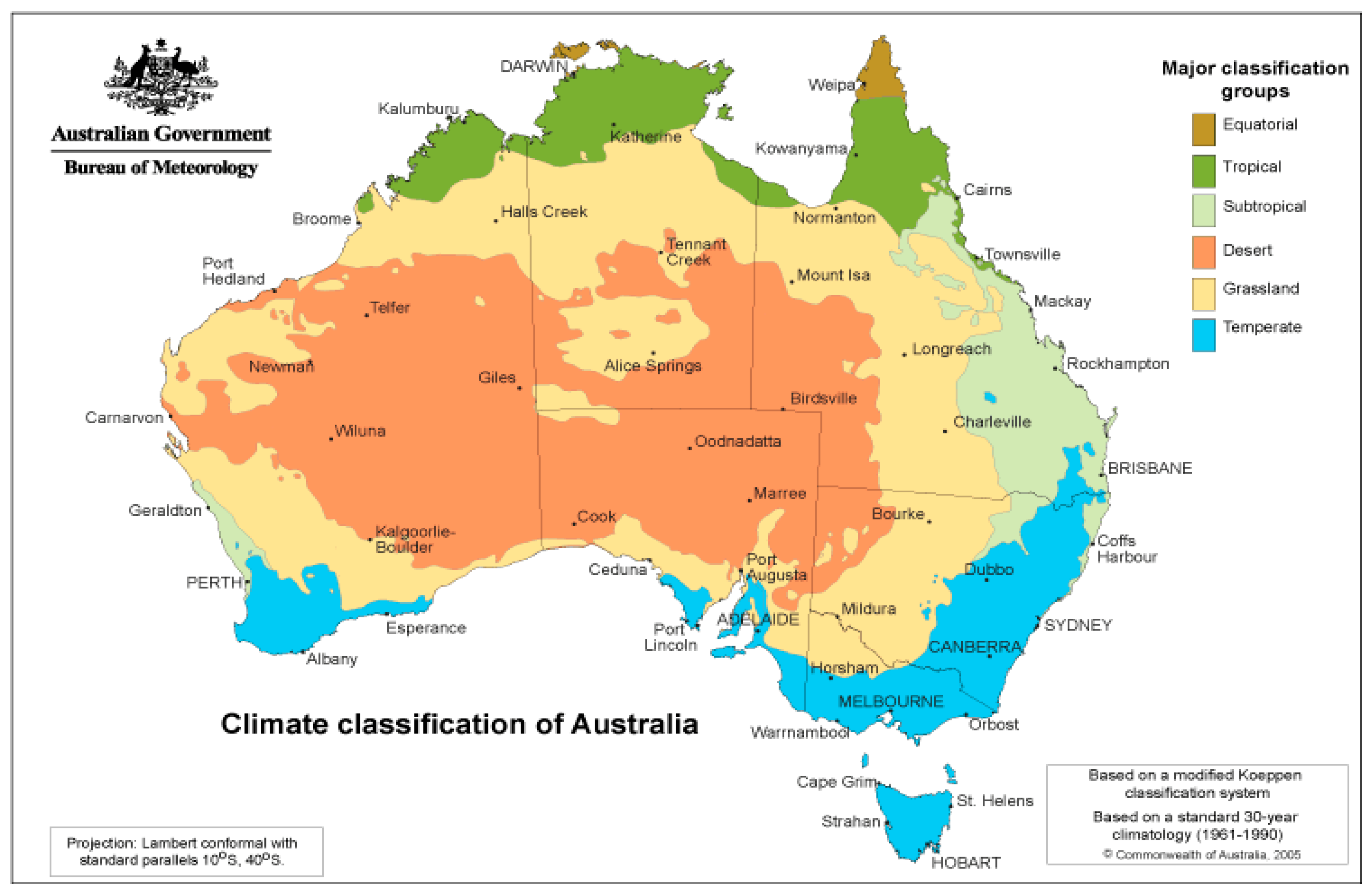
Figure A2.
The spatial distribution of annual rainfall and evaporation across Australia: (a) Mean annual rainfall, (b) Mean annual Potential Evapotranspiration (PET)The annual mean is calculated using 30 years of gridded data between 1981 and 2010 for rainfall and 1975-2005 data for pan evaporation (Bureau of Meteorology: http://www.bom.gov.au/climate/maps/averages/, accessed 24 May 2023).
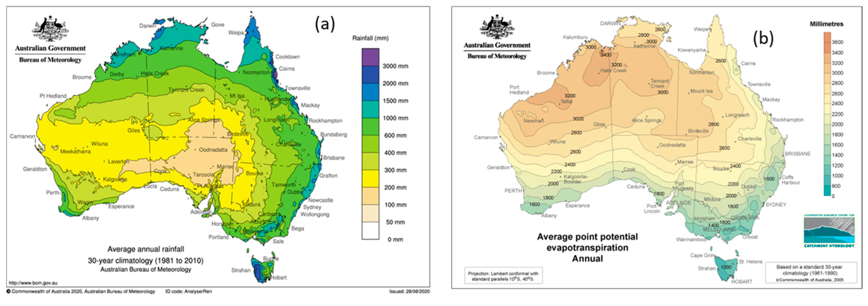
Figure A3.
Ungauged catchments and nodes: (a) North East Coast, (b) South East Coast NSW, (c) South East Coast Vic, (d) Tasmania, (e) Murray-Darling Basin, (f) South Australian Gulf, (g) South Western Plateau, (h) South West Coast, (i) Pilbara-Gascoyne, (j) North Western Plateau, (k) Tanami-Timor Sea Coast, and (l) Carpentaria Coast.
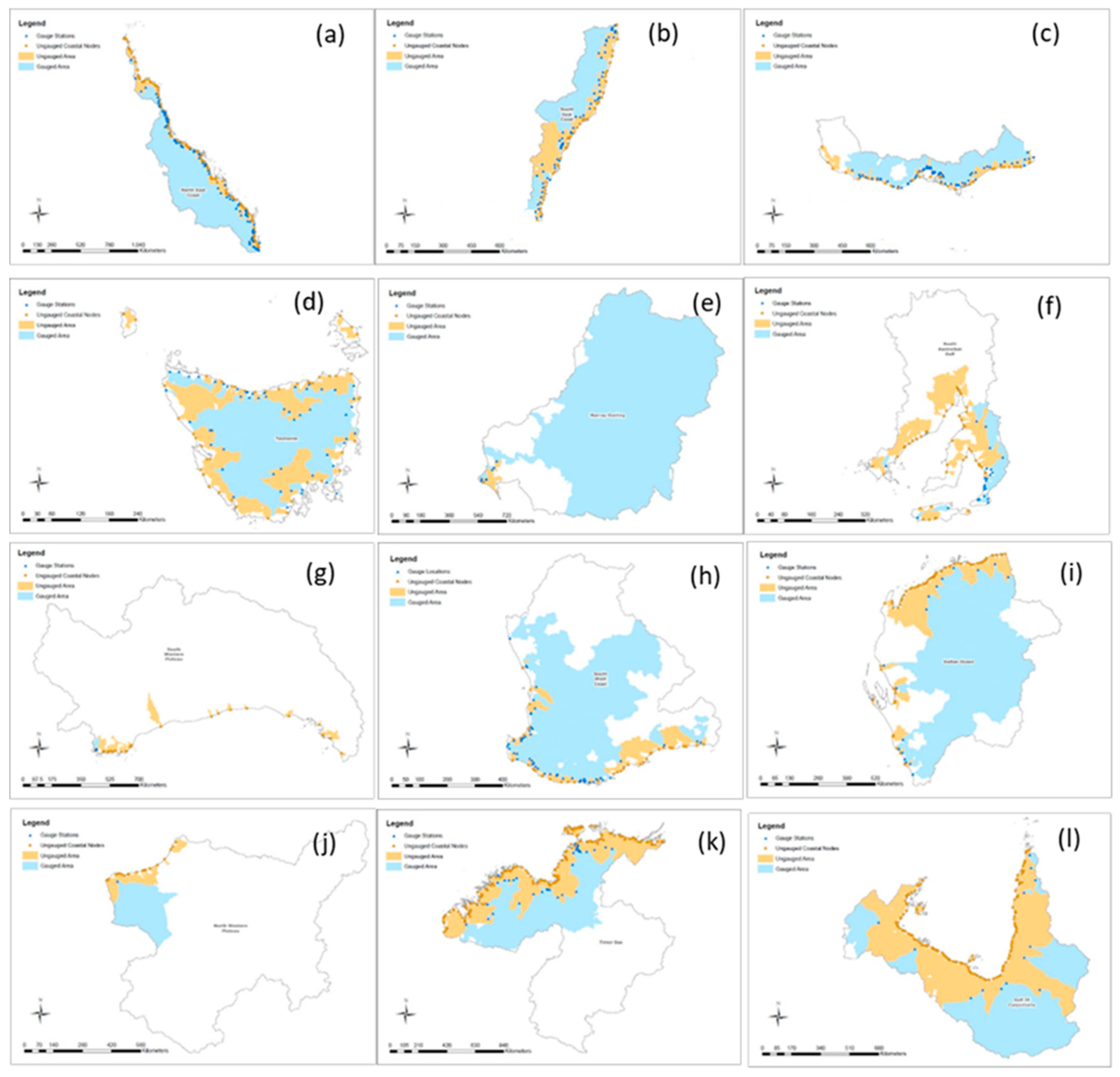
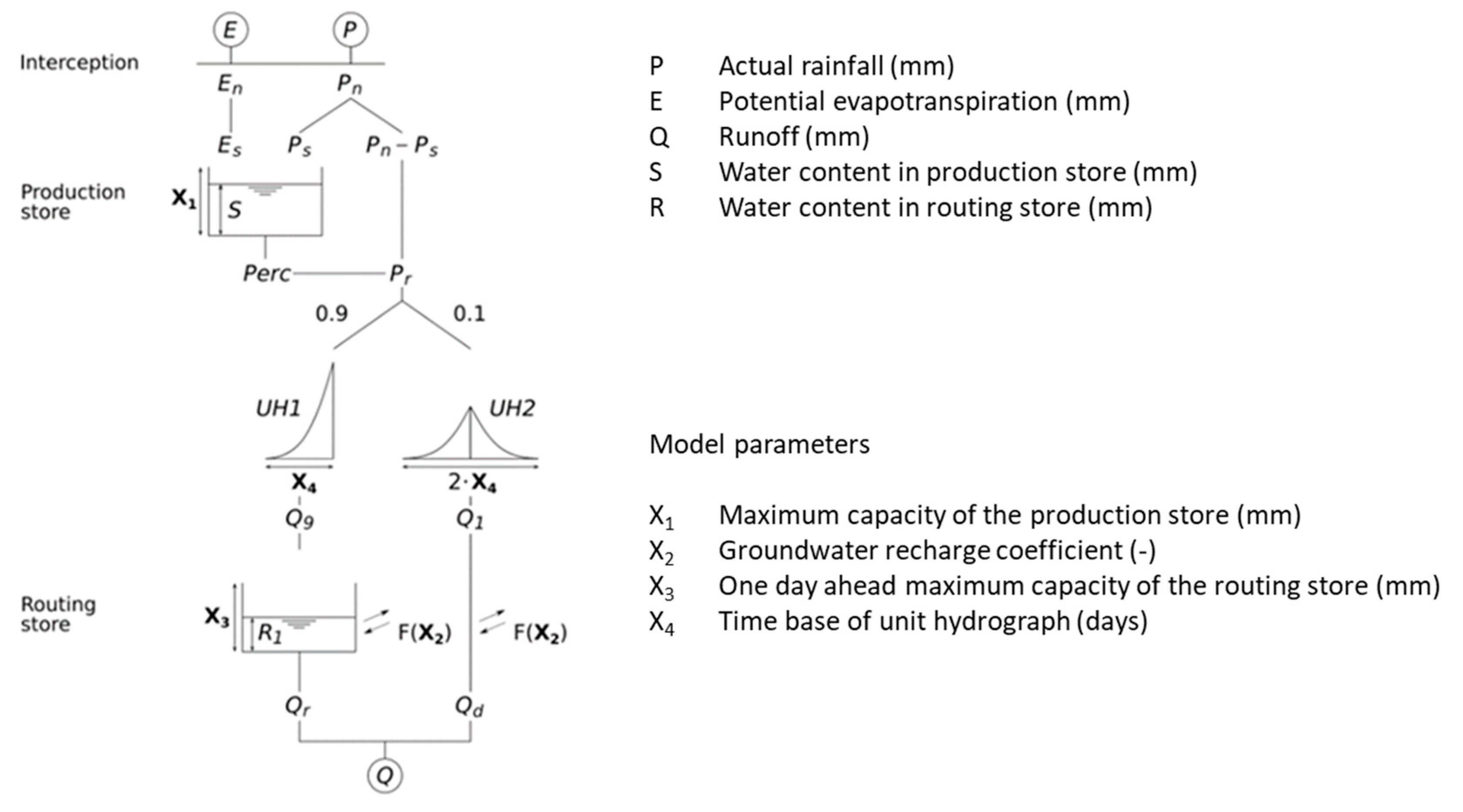
Figure A4.
Description of GR4J model - conceptual representation of a sub-catchment, with a river network and sub-areas ([16].
Figure A4.
Description of GR4J model - conceptual representation of a sub-catchment, with a river network and sub-areas ([16].
References
- Depetris, P.J. The Importance of Monitoring River Water Discharge. Front. Water 2021, 3, 1–7. [Google Scholar] [CrossRef]
- Dobriyal, P.; Badola, R.; Tuboi, C.; Hussain, S.A. A Review of Methods for Monitoring Streamflow for Sustainable Water Resource Management. Appl. Water Sci. 2017, 7, 2617–2628. [Google Scholar] [CrossRef]
- Kiang, J.E.; Stewart, D.W.; Archfield, S.A.; Osborne, E.B.; Eng, K. A National Streamflow Network Gap Analysis, Reston, VA, 2013.
- Zammit, C.; Sivapalan, M.; Viney, N.R.; Bari, M. Improvement of Physical Basis of Conceptual Model, LASCAM, with Explicit Inclusion of within Catchment Heterogeneity of Landscape Attributes. Int Congr. Model. Simul. 2003 2003, 921–926. [Google Scholar]
- Seibert, J.; Beven, K.J. Gauging the Ungauged Basin: How Many Discharge Measurements Are Needed? Hydrol. Earth Syst. Sci. 2009, 13, 883–892. [Google Scholar] [CrossRef]
- Hrachowitz, M.; Savenije, H.H.G.; Blöschl, G.; McDonnell, J.J.; Sivapalan, M.; Pomeroy, J.W.; Arheimer, B.; Blume, T.; Clark, M.P.; Ehret, U.; et al. A Decade of Predictions in Ungauged Basins (PUB)-a Review. Hydrol. Sci. J. 2013, 58, 1198–1255. [Google Scholar] [CrossRef]
- Sefton, C.E.M.; Howarth, S.M. Relationships between Dynamic Response Characteristics and Physical Descriptors of Catchments in England and Wales. J. Hydrol. 1998, 211, 1–16. [Google Scholar] [CrossRef]
- Hao, Z.; Jin, J.; Xia, R.; Tian, S.; Yang, W.; Liu, Q.; Zhu, M.; Ma, T.; Jing, C.; Zhang, Y. CCAM: China Catchment Attributes and Meteorology Dataset. Earth Syst. Sci. Data 2021, 13, 5591–5616. [Google Scholar] [CrossRef]
- Tramblay, Y.; Rouché, N.; Paturel, J.E.; Mahé, G.; Boyer, J.F.; Amoussou, E.; Bodian, A.; Dacosta, H.; Dakhlaoui, H.; Dezetter, A.; et al. ADHI: The African Database of Hydrometric Indices (1950-2018). Earth Syst. Sci. Data 2021, 13, 1547–1560. [Google Scholar] [CrossRef]
- Moggridge, B.J.; Thompson, R.M. Cultural Value of Water and Western Water Management: An Australian Indigenous Perspective. Aust. J. Water Resour. 2021, 25, 4–14. [Google Scholar] [CrossRef]
- Hamilton, S.; Doyle, M.; Cordery, I. The Value of Water Monitoring. Art Sci. Water - 36th Hydrol. Water Resour. Symp. HWRS 2015 2015, 972–978.
- National Marine Science Committee National Marine Science Plan 2015- 2025 Factsheet; National Marine science Committee, 2015; ISBN 9781925012026.
- Husain, A.; Reddy, J.; Bisht, D.; Sajid, M. Fractal Dimension of Coastline of Australia. Sci. Rep. 2021, 11, 1–10. [Google Scholar] [CrossRef]
- Melbourne-Thomas, J.; Constable, A.J.; Fulton, E.A.; Corney, S.P.; Trebilco, R.; Hobday, A.J.; Blanchard, J.L.; Boschetti, F.; Bustamante, R.H.; Cropp, R.; et al. Integrated Modelling to Support Decision-Making for Marine Social-Ecological Systems in Australia. ICES J. Mar. Sci. 2017, 74, 2298–2308. [Google Scholar] [CrossRef]
- Smith, D.C.; Fulton, E.A.; Apfel, P.; Cresswell, I.D.; Gillanders, B.M.; Haward, M.; Sainsbury, K.J.; Smith, A.D.M.; Vince, J.; Ward, T.M. Implementing Marine Ecosystem-Based Management: Lessons from Australia. ICES J. Mar. Sci. 2017, 74, 1990–2003. [Google Scholar] [CrossRef]
- Perrin, C.; Michel, C.; Andréassian, V. Improvement of a Parsimonious Model for Streamflow Simulation. J. Hydrol. 2003. [Google Scholar] [CrossRef]
- Chen, K.; McAneney, J. High-Resolution Estimates of Australia’s Coastal Population. Geophys. Res. Lett. 2006, 33. [Google Scholar] [CrossRef]
- CSIRO; BoM State of the Climate 2020: Australia’s Changing Climate; 2020; ISBN 978 1 4863 1509 3.
- Dey, R.; Lewis, S.C.; Arblaster, J.M.; Abram, N.J. A Review of Past and Projected Changes in Australia’s Rainfall. Wiley Interdiscip. Rev. Clim. Chang. 2019, 10. [Google Scholar] [CrossRef]
- Stern, H.; De Hoedt, G.; Ernst, J. Objective Classification of Australian Climates. Aust. Meteorol. Mag. 2000. [Google Scholar]
- Holper, P. Climate Change Science Information Paper: Australian Rainfall - Past, Present and Future. 2011, 18.
- Milly, P.C.D.; Dunne, K.A.; Vecchia, A. V. Global Pattern of Trends in Streamflow and Water Availability in a Changing Climate. Nature 2005, 438, 347–350. [Google Scholar] [CrossRef] [PubMed]
- Amirthanathan, E.; Bari, M.A.; Woldemeskel, F.; Narendra, K.; Feikema, P.M. Regional Significance of Historical Trends and Step Changes in Australian Streamflow. Hydrol. Earth Syst. Sci. 2023, 229–254. [Google Scholar] [CrossRef]
- Atkinson, R.; Power, R.; Lemon, D.; O’Hagan, R.G.; Dee, D.; Kinny, D. The Australian Hydrological Geospatial Fabric - Development Methodology and Conceptual Architecture. 2008, 57.
- Perraud, J.M.; Bridgart, R.; Bennett, J.C.; Robertson, D. Swift2: High Performance Software for Short-Medium Term Ensemble Streamflow Forecasting Research and Operations. In Proceedings of the Proceedings - 21st International Congress on Modelling and Simulation, MODSIM 2015; 2015. [Google Scholar]
- Coron, L.; Andréassian, V.; Perrin, C.; Lerat, J.; Vaze, J.; Bourqui, M.; Hendrickx, F. Crash Testing Hydrological Models in Contrasted Climate Conditions: An Experiment on 216 Australian Catchments. Water Resour. Res. 2012. [Google Scholar] [CrossRef]
- Van Esse, W.R.; Perrin, C.; Booij, M.J.; Augustijn, D.C.M.; Fenicia, F.; Kavetski, D.; Lobligeois, F. The Influence of Conceptual Model Structure on Model Performance: A Comparative Study for 237 French Catchments. Hydrol. Earth Syst. Sci. 2013. [Google Scholar] [CrossRef]
- Li, M.; Wang, Q.J.; Bennett, J.C.; Robertson, D.E. Error Reduction and Representation in Stages (ERRIS) in Hydrological Modelling for Ensemble Streamflow Forecasting. Hydrol. Earth Syst. Sci. 2016. [Google Scholar] [CrossRef]
- Kunnath-Poovakka, A.; Eldho, T.I. A Comparative Study of Conceptual Rainfall-Runoff Models GR4J, AWBM and Sacramento at Catchments in the Upper Godavari River Basin, India. J. Earth Syst. Sci. 2019. [Google Scholar] [CrossRef]
- Hapuarachchi, H.A.P.; Bari, M.A.; Kabir, A.; Hasan, M.M.; Woldemeskel, F.M.; Gamage, N.; Sunter, P.D.; Zhang, X.S.; Robertson, D.E.; Bennett, J.C.; et al. Development of a National 7-Day Ensemble Streamflow Forecasting Service for Australia. Hydrol. Earth Syst. Sci. 2022, 26, 4801–4821. [Google Scholar] [CrossRef]
- Duan, Q.; Sorooshian, S.; Gupta, V.K. Optimal Use of the SCE-UA Global Optimization Method for Calibrating Watershed Models. J. Hydrol. 1994. [Google Scholar] [CrossRef]
- Raupach, M.R.; Briggs, P.R.; Haverd, V.; King, E.A.; Paget, M.; Trudinger, C.M. The Centre for Australian Weather and Climate Research A Partnership between CSIRO and the Bureau of Meteorology Australian Water Availability Project (AWAP): CSIRO Marine and Atmospheric Research Component: Final Report for Phase 3; 2009; ISBN 9781921605314.
- Priestley, C.H.B.; Taylor, R.J. On the Assessment of Surface Heat Flux and Evaporation Using Large-Scale Parameters. Mon. Weather Rev. 1972, 100, 81–92. [Google Scholar] [CrossRef]
- Robertson, D.E.; Bennett, J.C.; Shrestha, D.; Wang, Q.J.; Enever, D.J.; Hapuarachchi, H.A.P.; Tuteja, N.K. The Performance of a New Ensemble Flood and Short-Term Streamflow Forecasting System for Australia. In Proceedings of the Hydrology and Water Resources Symposium 2014, HWRS 2014 - Conference Proceedings; Engineers Australia, 2014. 2014; 913–920. [Google Scholar]
- Bennett, J.C.; Ling, F.L.N.; Post, D.A.; Grose, M.R.; Corney, S.P.; Graham, B.; Holz, G.K.; Katzfey, J.J.; Bindoff, N.L. High-Resolution Projections of Surface Water Availability for Tasmania, Australia. Hydrol. Earth Syst. Sci. 2012, 16, 1287–1303. [Google Scholar] [CrossRef]
- Huang, Z.; Zhao, T. Predictive Performance of Ensemble Hydroclimatic Forecasts: Verification Metrics, Diagnostic Plots and Forecast Attributes. Wiley Interdiscip. Rev. Water 2022, 9, 1–30. [Google Scholar] [CrossRef]
- Razavi, T.; Coulibaly, P. Streamflow Prediction in Ungauged Basins: Review of Regionalization Methods. J. Hydrol. Eng. 2013, 18, 958–975. [Google Scholar] [CrossRef]
- Zanial, W.N.C.W.; Malek, M.A.; Reba, M.N.M. A Review on Rainfall Runoff Simulation at Ungauged Catchment. Int. J. Eng. Technol. 2018, 7, 162–167. [Google Scholar] [CrossRef]
- Belvederesi, C.; Zaghloul, M.S.; Achari, G.; Gupta, A.; Hassan, Q.K. Modelling River Flow in Cold and Ungauged Regions: A Review of the Purposes, Methods, and Challenges. Environ. Rev. 2022, 30, 159–173. [Google Scholar] [CrossRef]
- Parajka, J.; Viglione, A.; Rogger, M.; Salinas, J.L.; Sivapalan, M.; Blöschl, G. Comparative Assessment of Predictions in Ungauged Basins-Part 1: Runoff-Hydrograph Studies. Hydrol. Earth Syst. Sci. 2013, 17, 1783–1795. [Google Scholar] [CrossRef]
- Singh, R.; Archfield, S.A.; Wagener, T. Identifying Dominant Controls on Hydrologic Parameter Transfer from Gauged to Ungauged Catchments - A Comparative Hydrology Approach. J. Hydrol. 2014, 517, 985–996. [Google Scholar] [CrossRef]
- Liu, G.; Schwartz, F.W.; Tseng, K., H. ; Shum, and C.K. Discharge and Water-Depth Estimates for Ungauged Rivers:Combining Hydrologic, Hydraulic, and Inverse Modeling Withstage and Water-Area Measurements from Satellites. Water Resour. Res. 2015; 6017–6035. [Google Scholar] [CrossRef]
- Zhang, Y.Q.; Chiew, F.H.S. Evaluation of Regionalisation Methods for Predicting Runoff in Ungauged Catchments in Southeast Australia. 18th World IMACS Congr. MODSIM 2009 - Int. Congr. Model. Simul. Interfacing Model. Simul. with Math. Comput. Sci. Proc. 2009, 3442–3448.
- Zhang, Y.; Vaze, J.; Chiew, F.H.S.; Teng, J.; Li, M. Predicting Hydrological Signatures in Ungauged Catchments Using Spatial Interpolation, Index Model, and Rainfall-Runoff Modelling. J. Hydrol. 2014, 517, 936–948. [Google Scholar] [CrossRef]
- Narbondo, S.; Gorgoglione, A.; Crisci, M.; Chreties, C. Enhancing Physical Similarity Approach to Predict Runoff in Ungauged Watersheds in Sub-Tropical Regions. Water (Switzerland) 2020, 12, 2003–2012. [Google Scholar] [CrossRef]
- Kim, U.; Kaluarachchi, J.J. Application of Parameter Estimation and Regionalization Methodologies to Ungauged Basins of the Upper Blue Nile River Basin, Ethiopia. J. Hydrol. 2008, 362, 39–56. [Google Scholar] [CrossRef]
- Yilmaz, M.U.; Onoz, B. A Comparative Study of Statistical Methods for Daily Streamflow Estimation at Ungauged Basins in Turkey. Water (Switzerland) 2020, 12. [Google Scholar] [CrossRef]
- Singh, L.; Mishra, P.K.; Pingale, S.M.; Khare, D.; Thakur, H.P. Streamflow Regionalisation of an Ungauged Catchment with Machine Learning Approaches. Hydrol. Sci. J. 2022, 67, 886–897. [Google Scholar] [CrossRef]
- Bárdossy, A. Calibration of Hydrological Model Parameters for Ungauged Catchments. Hydrol. Earth Syst. Sci. 2007, 11, 703–710. [Google Scholar] [CrossRef]
- Swain, J.B.; Patra, K.C. Streamflow Estimation in Ungauged Catchments Using Regionalization Techniques. J. Hydrol. 2017, 554, 420–433. [Google Scholar] [CrossRef]
- Pool, S.; Vis, M.; Seibert, J. Regionalization for Ungauged Catchments — Lessons Learned From a Comparative Large-Sample Study. Water Resour. Res. 2021, 57, 1–25. [Google Scholar] [CrossRef]
- Abraham, T.; Liu, Y.; Tekleab, S.; Hartmann, A. Prediction at Ungauged Catchments through Parameter Optimization and Uncertainty Estimation to Quantify the Regional Water Balance of the Ethiopian Rift Valley Lake Basin. Hydrology 2022, 9. [Google Scholar] [CrossRef]
- Merz, R.; Tarasova, L.; Basso, S. Parameter’s Controls of Distributed Catchment Models—How Much Information Is in Conventional Catchment Descriptors? Water Resour. Res. 2020, 56, 1–18. [Google Scholar] [CrossRef]
- Oudin, L.; Kay, A.; Andráassian, V.; Perrin, C. Are Seemingly Physically Similar Catchments Truly Hydrologically Similar? Water Resour. Res. 2010, 46. [Google Scholar] [CrossRef]
- Bao, Z.; Zhang, J.; Liu, J.; Fu, G.; Wang, G.; He, R.; Yan, X.; Jin, J.; Liu, H. Comparison of Regionalization Approaches Based on Regression and Similarity for Predictions in Ungauged Catchments under Multiple Hydro-Climatic Conditions. J. Hydrol. 2012, 466–467, 37–46. [Google Scholar] [CrossRef]
- Rojas-Serna, C.; Lebecherel, L.; Perrin, C.; Andreassian, V.; Oudin, L. Water Resources Research. Water Resour. Assoc. 2016, 5, 2–2. [Google Scholar] [CrossRef]
- Azdy, R.A.; Darnis, F. Use of Haversine Formula in Finding Distance between Temporary Shelter and Waste End Processing Sites. J. Phys. Conf. Ser. 2020, 1500. [Google Scholar] [CrossRef]
- Althoff, D.; Rodrigues, L.N. Goodness-of-Fit Criteria for Hydrological Models: Model Calibration and Performance Assessment. J. Hydrol. 2021, 600, 126674. [Google Scholar] [CrossRef]
- Nash, J.E.; Sutcliffe, J. V. River Flow Forecasting through Conceptual Models Part I - A Discussion of Principles. J. Hydrol. 1970, 10, 282–290. [Google Scholar] [CrossRef]
- Moriasi, D.N.; Arnold, J.G.; Van Liew, M.W.; Bingner, R.L.; Harmel, R.D.; Veith, T.L. MODEL EVALUATION GUIDELINES FOR SYSTEMATIC QUANTIFICATION OF ACCURACY IN WATERSHED SIMULATIONS. Am. Soc. Agric. Biol. Eng. 2007, 50, 885–900. [Google Scholar]
- Chiew, F.H.S.; McMahon, T.A. Assessing the Adequacy of Catchment Streamflow Yield Estimates. Aust. J. Soil Res. 1993, 31, 665–680. [Google Scholar] [CrossRef]
- Kalin, L.; Isik, S.; Schoonover, J.E.; Lockaby, B.G. Predicting Water Quality in Unmonitored Watersheds Using Artificial Neural Networks. J. Environ. Qual. 2010, 39, 1429–1440. [Google Scholar] [CrossRef] [PubMed]
- Chen, H.; Luo, Y.; Potter, C.; Moran, P.J.; Grieneisen, M.L.; Zhang, M. Modeling Pesticide Diuron Loading from the San Joaquin Watershed into the Sacramento-San Joaquin Delta Using SWAT. Water Res. 2017, 121, 374–385. [Google Scholar] [CrossRef] [PubMed]
- Hapuarachchi, H.A.P.; Kabir, A.; Zhang, X.S.; Kent, D.; Bari, M.A.; Tuteja, N.K.; Hasan, M.M.; Enever, D.; Shin, D.; Plastow, K.; et al. Performance Evaluation of the National 7-Day Water Forecast Service. Proc. - 22nd Int. Congr. Model. Simulation, MODSIM 2017, 2017; 1815–1821. [Google Scholar] [CrossRef]
- Viney, N.R.; Vaze, J.; Chiew, F.H.S.; Perraud, J.; Post, D.A.; Teng, J. Comparison of Multi-Model and Multi-Donor Ensembles for Regionalisation of Runoff Generation Using Five Lumped Rainfall-Runoff Models. 18th World IMACS Congr. MODSIM 2009 - Int. Congr. Model. Simul. Interfacing Model. Simul. with Math. Comput. Sci. Proc. 2009; 3428–3434. [Google Scholar]
- Oudin, L.; Andréassian, V.; Perrin, C.; Michel, C.; Le Moine, N. Spatial Proximity, Physical Similarity, Regression and Ungaged Catchments: A Comparison of Regionalization Approaches Based on 913 French Catchments. Water Resour. Res. 2008, 44, 1–15. [Google Scholar] [CrossRef]
- Silberstein, R.; Aryal, S.; Pearcey, M.; Durrant, J.; Braccia, M.; Boniecka, L.; McCallum, S.; Smith, K.; Bari, M.; Hodgson, G.; et al. Rainfall-Runoff Modelling in South-West Western Australia. 3. Performance of the “Adopted Model”. South-West Western Australia Sustainable Yields Project: Technical Report. A Report to the Australian Government from the CSIRO South-West Western Australia; 2010. [Google Scholar]
- Sleziak, P.; Szolgay, J.; Hlavčová, K.; Parajka, J. Assessment of the Effectiveness of Calibrating a Conceptual Hydrological Model in Relation to Selected Catchment Characteristics. Catchment Process. Reg. Hydrol. Confronting Exp. Model. Carpathian Drain. basins 2015, 1–9. [Google Scholar]
- Shu, C.; Ouarda, T.B.M.J. Improved Methods for Daily Streamflow Estimates at Ungauged Sites. Water Resour. Res. 2012, 48, 1–15. [Google Scholar] [CrossRef]
- Beck, H.E.; van Dijk, A.I.J.M.; Roo, A. de; GMiralles, D.J.; McVicar, T.R.; Schellekens, J.; A. , B.L. Global-Scale Regionalization of Hydrologic Model Parameters. J. Am. Water Resour. Assoc. 2016, 3599–3622. [Google Scholar] [CrossRef]
- National Land and Water Resources Audit, N. Australian Water Resource Assessment 2000; Canberra. 2000. [Google Scholar]
- CSIRO Water in the Mitchell Region, Pp 347-416 in CSIRO (2009) Water in the Gulf of Carpentaria Drainage Division. A Report to the Australian Government from the CSIRO Northern Australia Sustainable Yields Project. 2009.
- Mayer, Xanthe; Ruprecht, J.; Bari, M. Stream Salinity Status and Trends in South-West Western Australia, 2005.
- McFarlane, D. Water Resource Assessment for the Pilbara Region A Report to the West Australian Government and Industry Partners from the CSIRO Pilbara Water Resource Assessment, 2015.
- CSIRO Water in the Timor Sea Drainage Division. A Report to the Australian Government from the CSIRO Northern Australia Sustainable Yields Project. CSIRO Water for a Healthy Country Flagship, Australia.; Australia. 2009.
- CSIRO Water in the Timor Sea Drainage Division. A Report to the Australian Government from the CSIRO Northern Australia Sustainable Yields Project. CSIRO Water for a Healthy Country Flagship, Australia.; Australia. 2009.
Figure 1.
Location of gauged and ungauged catchments discharging to the entire Australian coastline.
Figure 1.
Location of gauged and ungauged catchments discharging to the entire Australian coastline.
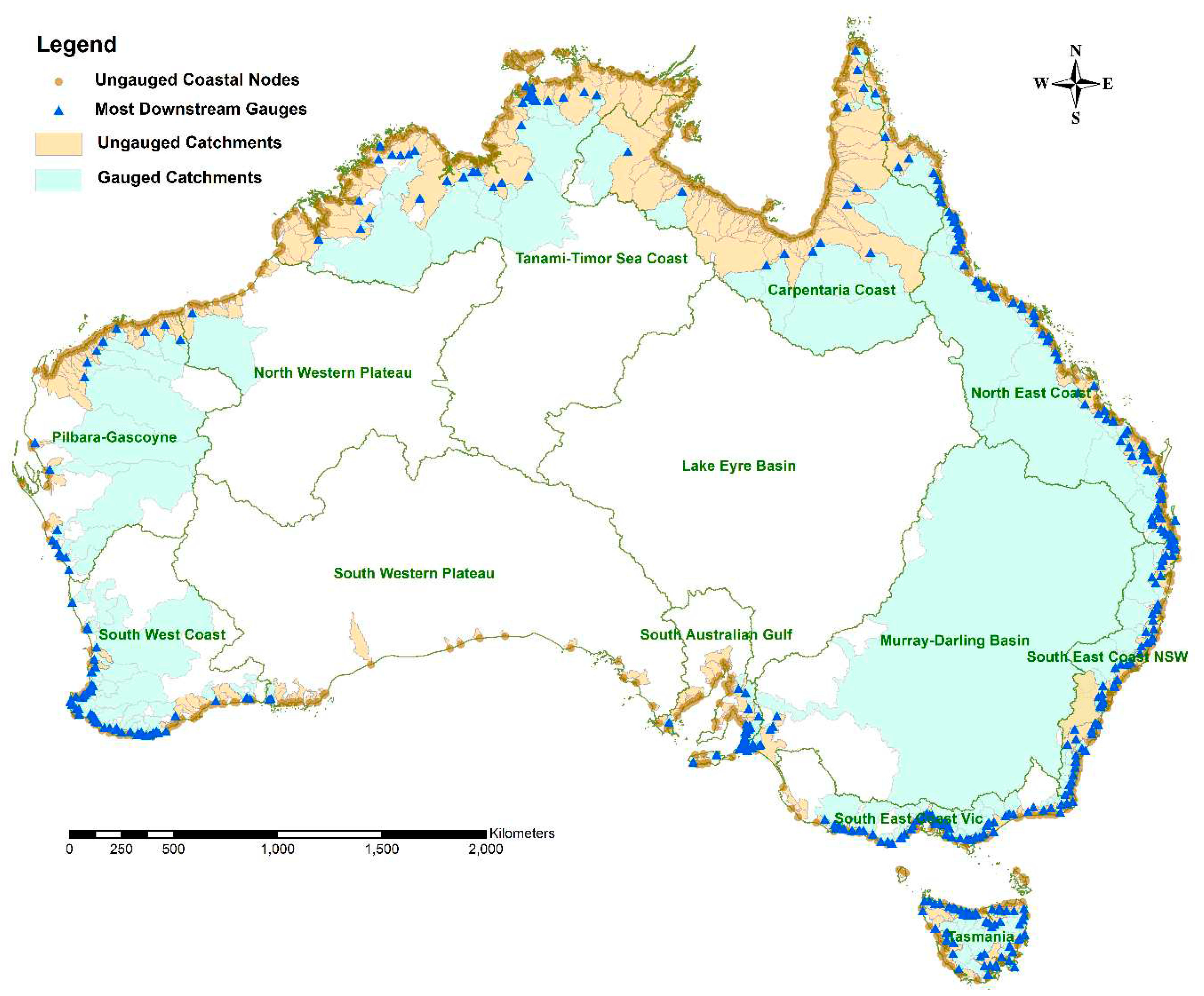
Figure 2.
Conceptualisation of Ungauged Catchment (a) Category 1, (b) Category 2, and (c) Category 3 and 4.
Figure 2.
Conceptualisation of Ungauged Catchment (a) Category 1, (b) Category 2, and (c) Category 3 and 4.
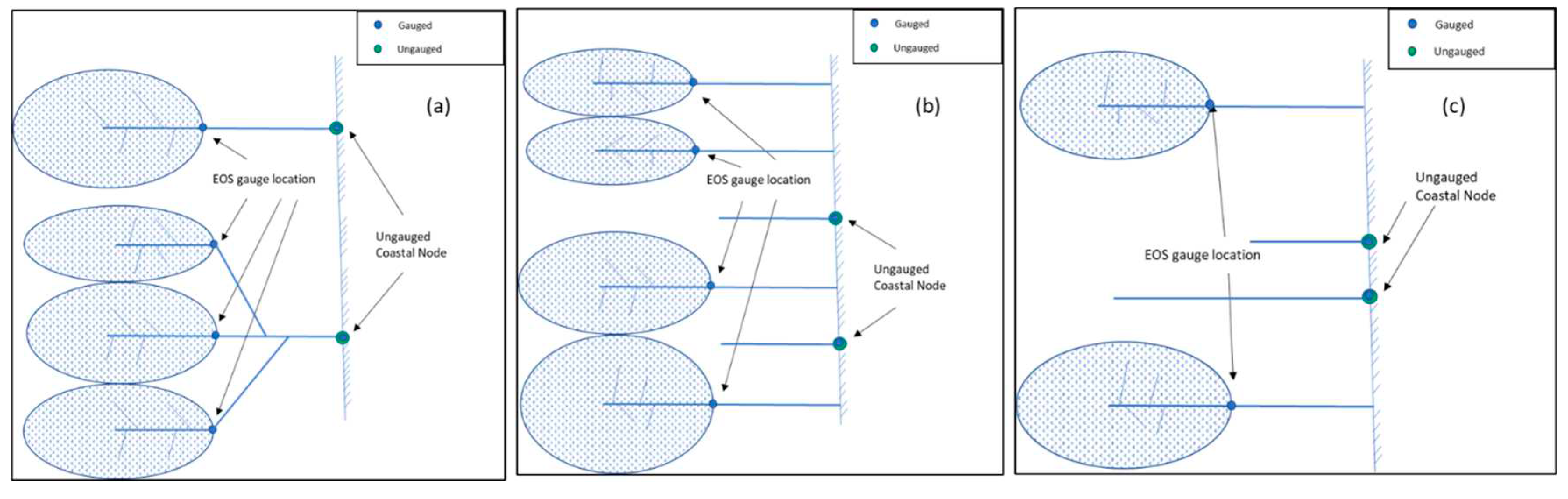
Figure 3.
An example of the gap-filled streamflow data. The continuous observed streamflow is shown in blue and red lines indicate poor quality data captured by the QATS (Quality Assurance of Time-Series) tool.
Figure 3.
An example of the gap-filled streamflow data. The continuous observed streamflow is shown in blue and red lines indicate poor quality data captured by the QATS (Quality Assurance of Time-Series) tool.

Figure 4.
Flow diagram for estimating streamflow at ungauged locations.
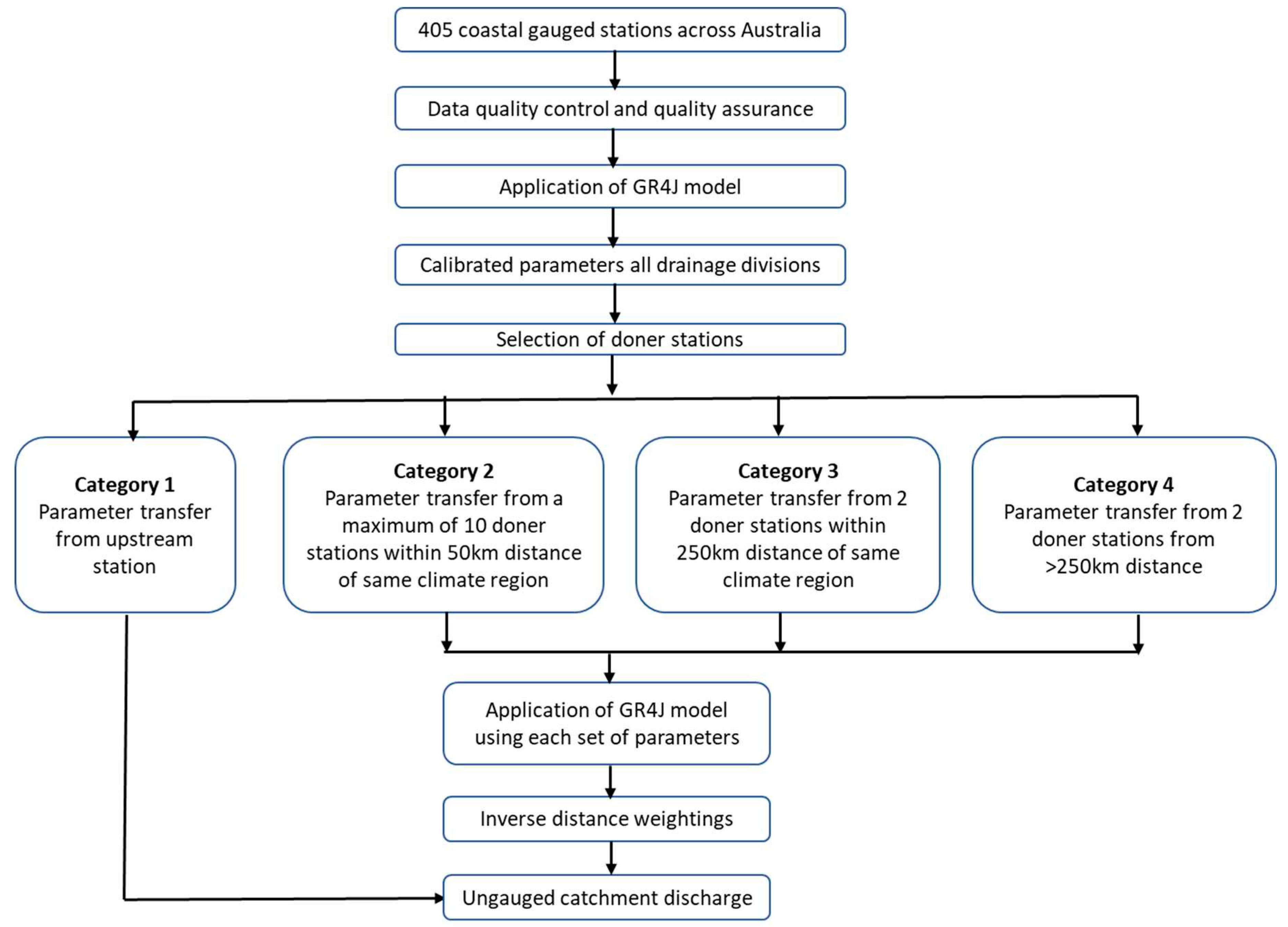
Figure 5.
Daily observed and simulated streamflow hydrographs and flow duration curves – typical catchments from (a) TAS and (b) SWC and (c) SAG drainage divisions.
Figure 5.
Daily observed and simulated streamflow hydrographs and flow duration curves – typical catchments from (a) TAS and (b) SWC and (c) SAG drainage divisions.
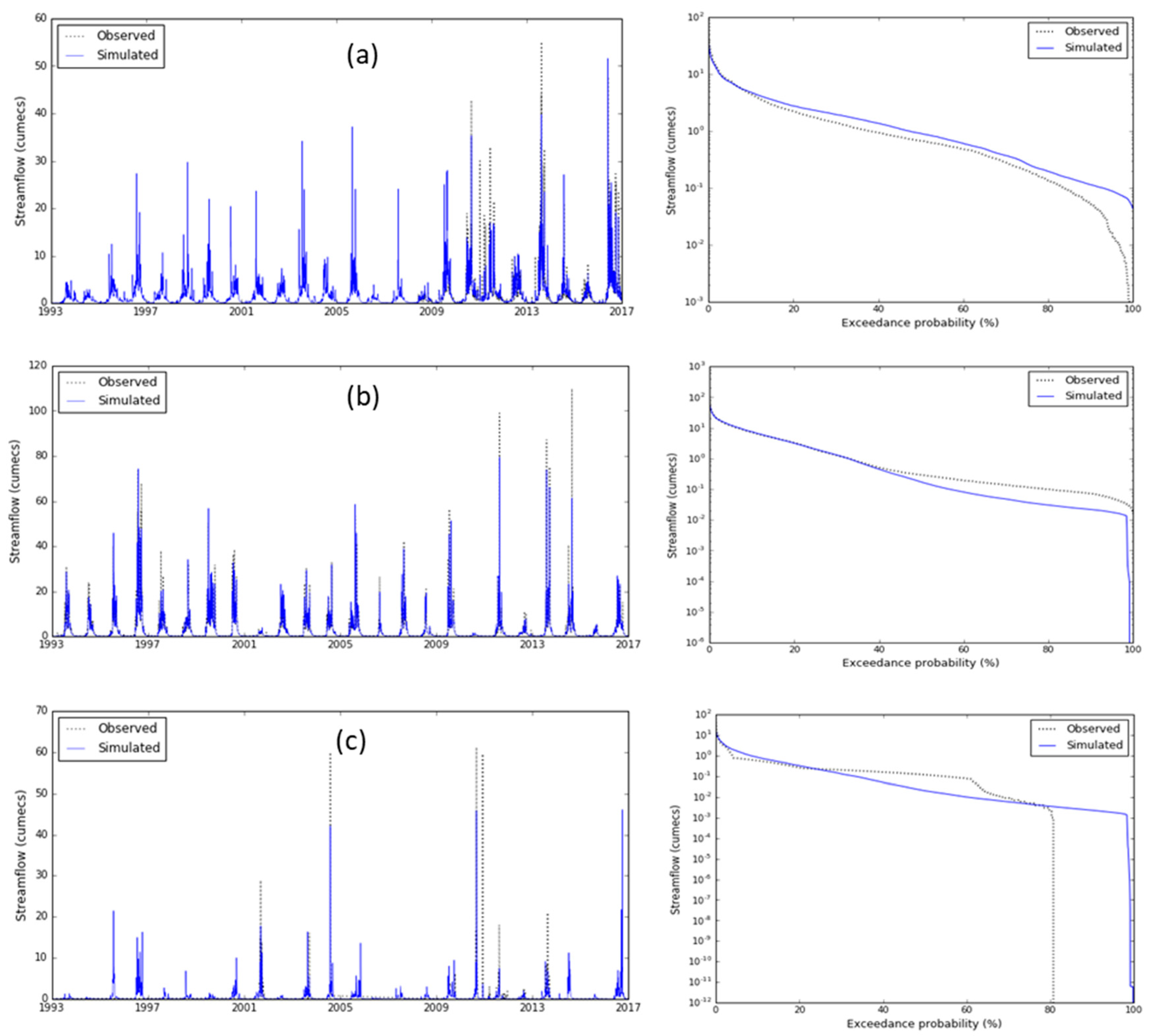
Figure 6.
Daily streamflow scatter plots – a typical catchment from: (a) NEC, (b) SEN, (c) SEV, (d) TAS, (e) MDB, (f) SAG, (g) SWC, (h) PG and (i) CC drainage divisions.
Figure 6.
Daily streamflow scatter plots – a typical catchment from: (a) NEC, (b) SEN, (c) SEV, (d) TAS, (e) MDB, (f) SAG, (g) SWC, (h) PG and (i) CC drainage divisions.
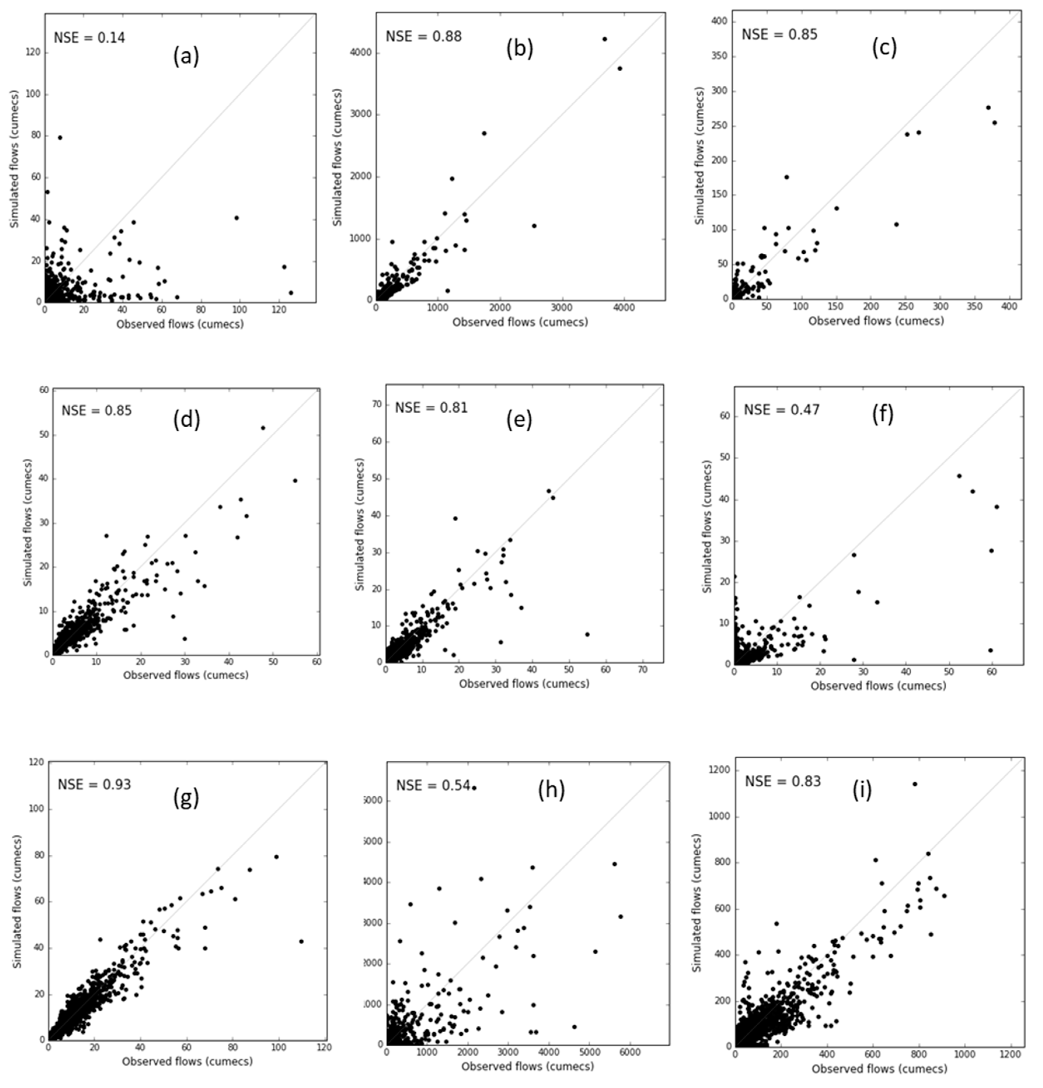
Figure 7.
Calibrated (a) NSE and (b) bias of catchments within all drainage divisions.
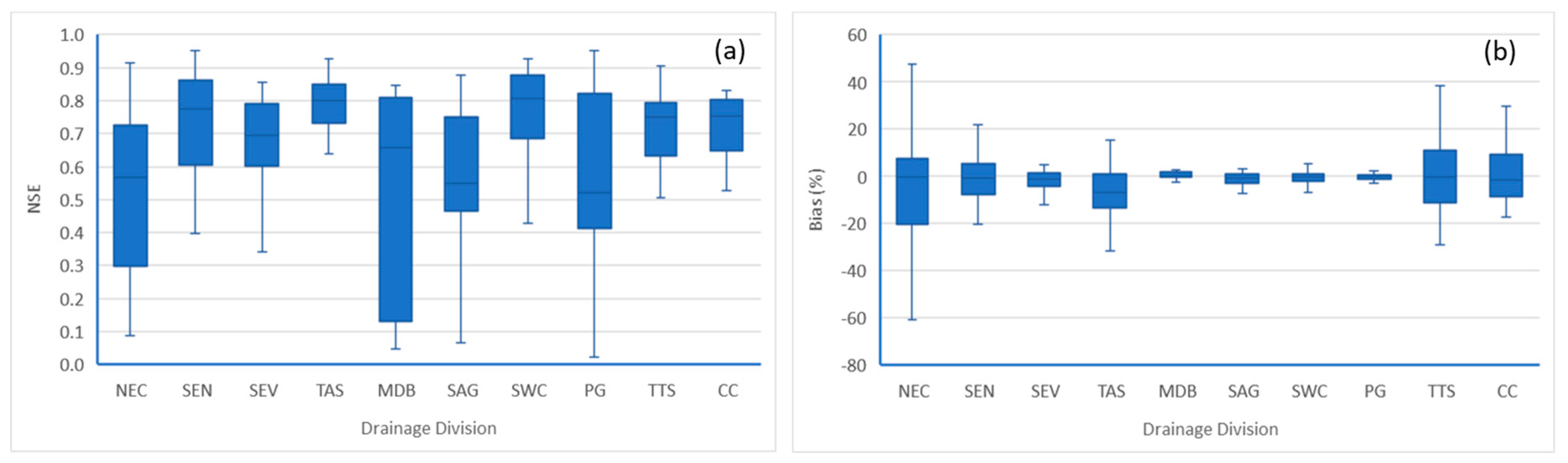
Figure 8.
Relationship between (a) NSE, (b) PBias for all gauged catchment areas.
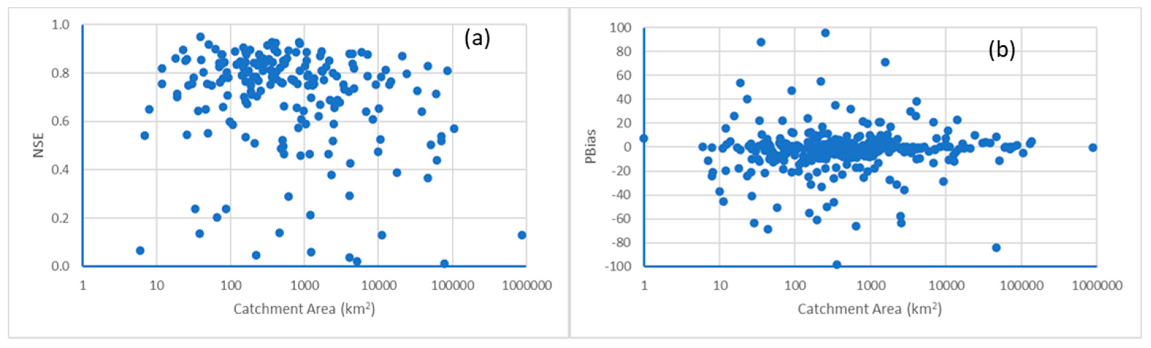
Figure 9.
Proportion of gauged and ungauged (a)streamflow volumes (b) catchment areas – Category 1 catchments.
Figure 9.
Proportion of gauged and ungauged (a)streamflow volumes (b) catchment areas – Category 1 catchments.
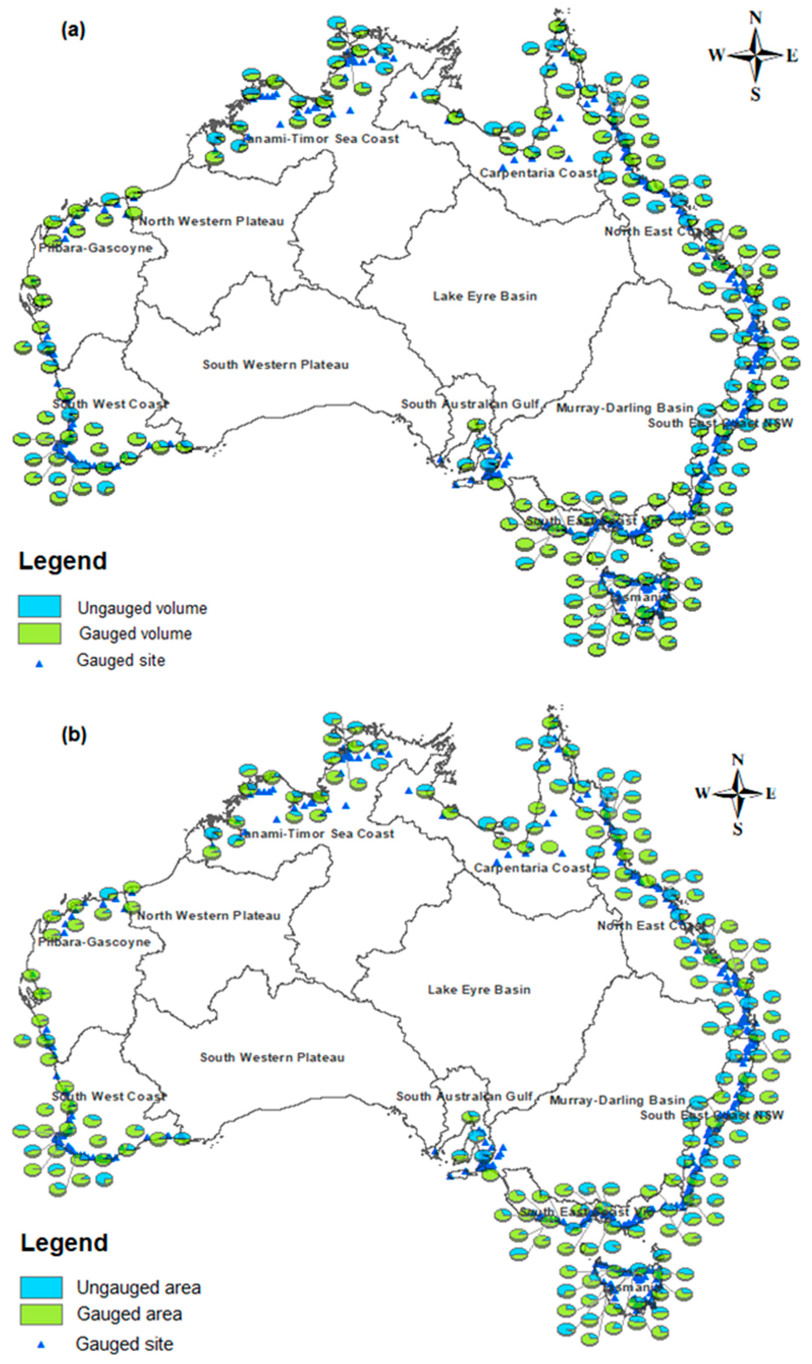
Figure 10.
Observed and simulated mean annual runoff ratio for all ungauged and gauged catchments in all drainage divisions.
Figure 10.
Observed and simulated mean annual runoff ratio for all ungauged and gauged catchments in all drainage divisions.
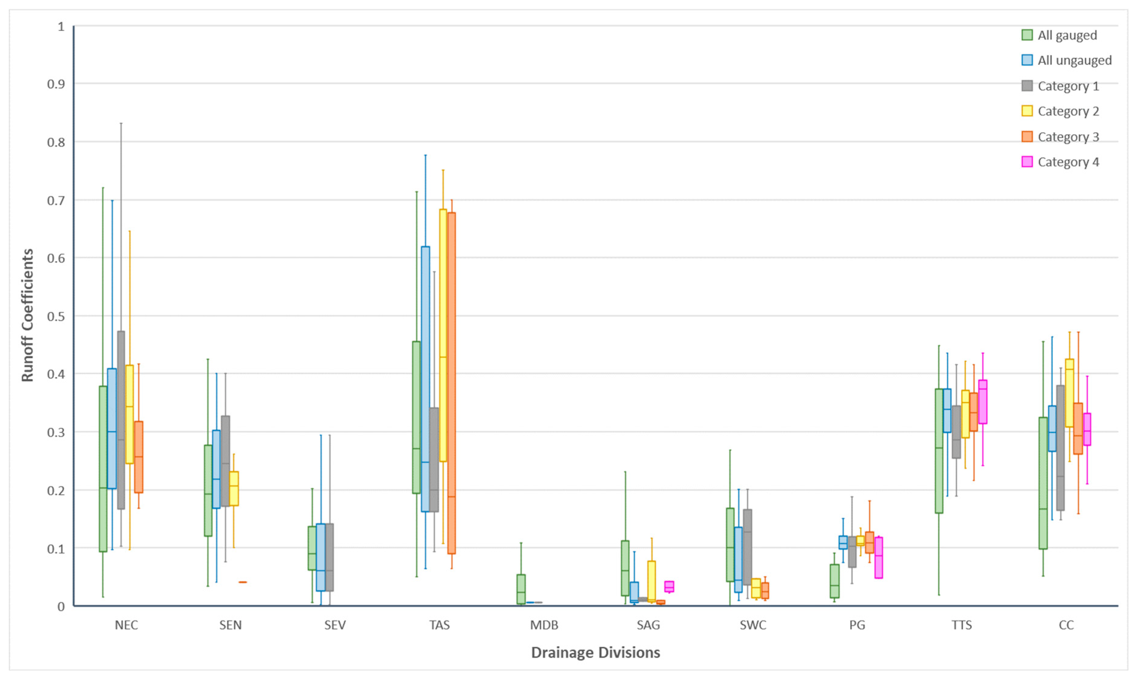

Table 1.
Metrics used for model performance evaluation.
| Metrics | Abbreviation | Equation | Description |
|---|---|---|---|
| Nash-Sutcliffe Efficiency | NSE | Compares the mean square error against the observation variable. It varies between -∞ to 1 with a perfect score of 1. | |
| Percent bias | PBias | Measures the difference between the mean/median of forecast variable and observation. It varies between -∞ to +∞ with a perfect score of 0. |
Table 2.
Diagnostic plots used for model performance evaluation.
| Plot | X-axis | Y-axis | Description |
| Time series | Time step | Simulated and observed streamflow | Daily and monthly discharge |
| Flow-duration | Probability of exceedance (%) | Simulated and observed streamflow | Daily and monthly streamflow |
| Correlation scatter | Observed streamflow | Simulated streamflow | Daily, monthly and annual total streamflow |
Table 3.
Performance ratings of Nash-Sutcliffe Efficiency (NSE) and percent bias (PBias) statistics for daily streamflow.
Table 3.
Performance ratings of Nash-Sutcliffe Efficiency (NSE) and percent bias (PBias) statistics for daily streamflow.
| Performance Rating | NSE | Catchment (%) | Abs(PBias) % | Catchment (%) |
| Very Good | NSE≥0.70 | 57 | Abs(PBias) ≤25 | 88 |
| Good | 0.5≤NSE<0.7 | 23 | 25<Abs(PBias) ≤50 | 6 |
| Satisfactory | 0.3≤NSE<0.5 | 8 | 50<Abs(PBias) ≤70% | 3 |
| Unsatisfactory | NSE<0.3 | 12 | Abs(PBias)>70% | 3 |
Table 4.
List of gauged and ungauged catchments and areas (1000 km2) in each of the drainage divisions.
Table 4.
List of gauged and ungauged catchments and areas (1000 km2) in each of the drainage divisions.
| Drainage Division | Gauged Stations | Ungauged Area | |||||
| No. | Area | 1 | 2 | 3 | 4 | Total | |
| North East Coast (NEC) | 83 | 366 | 35 | 13 | 10 | 0 | 58 |
| South East Coast NSW (SEN) | 60 | 75 | 44 | 4 | 2 | 0 | 50 |
| South East Coast VIC (SEV) | 60 | 75 | 11 | 4 | 1 | 0 | 16 |
| Tasmania (TAS) | 53 | 38 | 21 | 1 | 0 | 0 | 22 |
| Murray-Darling Basin (MDB) | 7 | 882 | 9 | 0 | 0 | 0 | 9 |
| South Australian Gulf (SAG) | 23 | 9 | 5 | 5 | 8 | 6 | 24 |
| South West Coast (SWC) | 55 | 159 | 8 | 8 | 4 | 0 | 21 |
| Pilbara Gascoyne (PG) | 17 | 276 | 11 | 19 | 18 | 3 | 52 |
| Tanami-Timor Sea Coast (TTS) | 33 | 312 | 91 | 21 | 95 | 26 | 233 |
| Carpentaria Coast (CC) | 13 | 304 | 141 | 21 | 81 | 73 | 315 |
| North Western Plateau (NWP) | 1 | 53 | 0 | 6 | 3 | 7 | 17 |
| South Australian Plateau (SAP) | 0 | 0 | 2 | 1 | 4 | 11 | 18 |
| Total | 405 | 2,549 | 378 | 106 | 231 | 128 | 835 |
Table 5.
Mean annual discharge (1000 GL) from each of the drainage divisions including gauged and ungauged catchments.
Table 5.
Mean annual discharge (1000 GL) from each of the drainage divisions including gauged and ungauged catchments.
| Drainage Division | Overall total | Gauged | Ungauged | ||||
| 1 | 2 | 3 | 4 | Total | |||
| North East Coast (NEC) | 58.47 | 35.67 | 11.73 | 7.34 | 3.73 | 22.80 | |
| South East Coast NSW (SEN) | 20.4 | 11.23 | 8.04 | 1.07 | 0.06 | 9.18 | |
| South East Coast VIC (SEV) | 11.95 | 10.87 | 0.92 | 0.11 | 0.05 | 1.07 | |
| Tasmania (TAS) | 39.07 | 25.12 | 13.10 | 0.85 | 13.95 | ||
| Murray-Darling Basin (MDB) | 4.38 | 4.38 | 0.00 | 0.00 | |||
| South Australian Gulf (SAG) | 0.23 | 0.04 | 0.02 | 0.11 | 0.02 | 0.04 | 0.19 |
| South West Coast (SWC) | 3.48 | 2.57 | 0.73 | 0.15 | 0.03 | 0.91 | |
| Pilbara Gascoyne (PG) | 6.15 | 4.52 | 0.34 | 0.70 | 0.50 | 0.09 | 1.63 |
| Tanami-Timor Sea Coast (TTS) | 146.15 | 61.72 | 27.16 | 9.69 | 38.12 | 9.46 | 84.43 |
| Carpentaria Coast (CC) | 109.44 | 30.25 | 25.00 | 8.99 | 26.52 | 18.68 | 79.19 |
| North Western Plateau (NWP) | 9.41 | 1.48 | 7.38 | 0.03 | 0.28 | 0.24 | 7.93 |
| South Australian Plateau (SAP) | 10.91 | 0.00 | 10.83 | 0.01 | 0.02 | 0.05 | 10.90 |
| Total | 419.95 | 187.85 | 105.3 | 29.0 | 69.3 | 28.5 | 232.2 |
Disclaimer/Publisher’s Note: The statements, opinions and data contained in all publications are solely those of the individual author(s) and contributor(s) and not of MDPI and/or the editor(s). MDPI and/or the editor(s) disclaim responsibility for any injury to people or property resulting from any ideas, methods, instructions or products referred to in the content. |
© 2023 by the authors. Licensee MDPI, Basel, Switzerland. This article is an open access article distributed under the terms and conditions of the Creative Commons Attribution (CC BY) license (http://creativecommons.org/licenses/by/4.0/).
Copyright: This open access article is published under a Creative Commons CC BY 4.0 license, which permit the free download, distribution, and reuse, provided that the author and preprint are cited in any reuse.


