Submitted:
14 November 2023
Posted:
15 November 2023
You are already at the latest version
Abstract
The agricultural sector is currently confronting multifaceted challenges such as an increased food demand, a slow adoption of sustainable farming, a need for climate-resilient food systems, resource inequity, and protection of the small-scale farmers’ practices, all issues integral to food security and environmental health. Remote sensing technologies can assist precision agriculture to effectively address these complex problems, by providing farmers with a high-resolution lens. The use of vegetation indices (VIs) is an essential component of remote sensing, which combine the variability of spectral reflectance value (derived from remote sensing data) with the growth stage of crops. Currently a wide array of VIs is available that could be used to provide a classification and an evaluation of the state and health of crops. However precisely this high number leads to difficulties in selecting the best VI and combination of VIs for a specific objective. Without a thorough documentation and analysis of appropriate VIs, users might be confronted with difficulties in using remote sensing data or even with a very low accuracy of the results. Thus, the objective of this review is to conduct a critical analysis of the existing state of the art on the most important features related to the effective use of VIs for the discrimination and monitoring of the most important agricultural crops (wheat, corn, sunflower, soybean, rape, potatoes, and forage crops), grasslands and meadows. This data could be highly useful for all the stakeholders involved in agricultural activities (from farmers, researchers up to institutions dealing with the centralization and monitoring of agricultural crops).
Keywords:
precision agriculture
; crop classification
; satellite data
; spatial analysis
; spectral reflectance
1. Introduction
Food security is of paramount importance as it not only ensures that individuals and communities have consistent access to sufficient, safe, and nutritious food but it is also related to the well-being, stability, and progress of communities [1]. The agri-food sector continues to be driven by climate change, increasingly unpredictable weather patterns, and global population growth [2]. In this context, the mapping and monitoring of agricultural crops through precision agriculture and remote sensing serve as the “dynamic eyes and ears” of modern farming. They enable gathering and processing of data in real-time and offer insights for optimizing the management of resource and contributing to increasing the yields and sustainability of the farming practices in an ever-evolving agricultural landscape.
The heterogeneity of agricultural landscape composed by croplands and meadows typically results from different land use practices and applications with regard to their ecosystem services [3]. These ecosystem services include all the major sections provided in the Common International Classification of Ecosystem Services (CICES) [4]: a) provisioning services (crop production, forage and livestock grazing, pollination); b) regulation and maintenance services (water regulation, carbon sequestration, soil fertility, natural pest control); c) supporting services (biodiversity); d) cultural services (recreation and aesthetic, cultural and traditional); and e) economic services (particularly for farmers and rural communities). The provision of these ecosystem services is vital for the existence and well-being communities, but it can be extremely variable across the various regions of the globe [3]. It is influenced by a series of factors such as: weather conditions, soil quality, land management, biodiversity, water resources, and cultural, societal, policy and regulation factors. Thus, the current need is to provide an accurate classification and effective management of the agricultural areas precisely because of the importance of the land covered by cropland and meadows and the complexity of the work involved in their conservation.
While mapping involves creating a static representation or inventory of the spatial distribution of different crops within a given area (typically done at the beginning of the growing season), monitoring, on the other hand, is an ongoing process of tracking the dynamic changes in crop health and condition throughout the growing season. In the context of the current global population growth and climate change, Mercier et al. [5] showed that monitoring of agricultural crops is an essential tool to effectively address these issues. In addition, other studies also pointed out that monitoring of agricultural crops contributes to the estimation of yields [6], prevention of disease and pest attack [7], application of fertilizers [8], as well as water resource management [9]. Data on the types and productive potential of agricultural crops are often rare, especially in low- and middle-income countries. Thus, remote sensing, through satellite images, can be utilized to fill these gaps, often in combination with artificial intelligence algorithms. As such, the mapping of agricultural land and monitoring of the state and well-being of crops using remote sensing is a key contribution to food security monitoring systems [10-12]. This technology holds an important advantage since most of the satellite image databases are available for free and have global coverage.
The data collected through remote sensing technologies typically includes information related to vegetation indices (VIs; all the abbreviations used in this manuscript can be found in Table S1), which provide valuable insights into the health, growth, and condition of crops and vegetation in agricultural areas [13]. These indices can be calculated using data collected through remote sensing technologies such as satellite and aerial imagery, drones, or ground-based sensors. VIs could be very useful for both agricultural land use classification and monitoring of agricultural crops. However, the high number of VIs that can be computed and are available in the existing literature hampers the process associated with their efficient selection and use [14]. Moreover, a misclassification of the VIs caused by the spectral similarities of different crop types, could deliver inaccuracies in assessing the health of crops, thus interfering with the management decisions.
In this context, this review aims to assess the existing state of the art on the major VIs used to identify, discriminate, and monitor the some of the most important agricultural crops in Europe (wheat, corn, sunflower, soybean, rape, potatoes, and forage crops) and grasslands and meadows. Since these land use categories are of particular food and economic importance, we believe that a critical synthesis of the most relevant studies on the identification and characterization of the VIs according to their advantages and constrains, can be extremely useful for all the stakeholders involved in agricultural activities (from farmers, researchers up to institutions dealing with the centralization and monitoring of agricultural crops). A total of 113 scientific papers indexed in the major International Data Bases (Web of Science Core collection, Scopus, ScienceDirect, and Google Scholar) were selected, based on the following key-words: satellite imaging, agriculture and maize/ corn/ wheat/ rapeseed/ soy/ potato/ alfalfa/ grassland. After an in-depth analysis of these scientific papers, we synthetized the most relevant information required for their effective selection and use in studies concerning the 7 agricultural crops, grasslands and meadows. Keeping this in mind, the main objectives of our study were: (1) synthesizing the information available in the scientific literature on the main VIs that can be used in studies aiming to map and monitor the 7 agricultural crops, grasslands and meadows; (2) highlighting the main specificities of the VIs available through the use of satellite data, unmanned aerial vehicles (UAVs) and sensors; (3) highlighting the main advantages and limitations in the use of VIs for the crops studied; (4) concluding remarks and discussion on future research directions that may lead to a better accuracy of the results.
2. Insights into the Use of Remote Sensing Data for Crop Classification and Management
2.1. From Spectral Data to Crop Data
Remote sensing technology, with its wide-ranging applications, has transformed the agricultural landscape by providing valuable data for precise crop classification and management. An essential component of this technology is the use of VIs derived from remote sensing data (typically obtained from satellite or aerial imagery). The process of calculating a certain VI for an agricultural crop involves collecting and processing spectral data from remote sensing imagery, tailored to the unique characteristics and growth stages of that crop. This process is based on measuring the reflectance of light at specific wavelengths to create the index [15].
Remote sensing VIs are derived from a variety of sources, including: 1) satellites (data from Earth-observing satellites); 2) aerial imagery (collected from aircraft, drones, or other platforms); 3) hyperspectral sensors (able to capture data at hundreds of narrow spectral bands); and 4) ground-based sensors (useful in crop monitoring). The major source of remote sensing data used in most of the agricultural studies conducted so far is typically satellite imagery, especially from Earth-observing satellites [16]. As shown in Figure 1a, 64.62% from the total scientific papers analyzed in this review were based on satellite data, while only 22.12% were based on aerial data (mainly UAVs), and 13.27% from multiple sources. Figure 1b shows that all of the 8 agricultural land categories were subjected to studies from all of the 3 data sources, with a small percentage of scientific papers based on multiple source data (among all of the crops studied).
The preferences expressed in the favor of satellite imagery could be explained, at least partially, by the advantages held by this remote sensing data source in comparison with aerial and/or multi-source data, since satellite data (1) are less expensive (in many cases free of charge), (2) allow the analysis of larger areas, (3) the analysis are easily replicable and are not influenced by local climate conditions (i.e. wind). Even so, satellite imagery is not perfect as presented in detail in Section 3 for each of the eight agricultural crops analyzed in this review.
Some of the satellite imagery sources are available for free (MODIS - Moderate Resolution Imaging Spectroradiometer, provided by NASA; Landsat, provided by NASA and the U.S. Geological Survey; and Sentinel Satellites, provided by the European Space Agency – ESA), while others have restricted access, under a paywall (Maxar Technologies (formerly DigitalGlobe), Airbus, and Planet Labs). While both have their advantages and limitations, the choice of one over another should be relative to the specific objectives, available resources of agricultural users, and budget. Free satellite data are valuable for many applications and research use-cases, while commercial satellites offer an additional flexibility, high-resolution imagery, and tailored solutions.
As shown in Figure 2a, most of the remote sensing data sources used so far in scientific publication in the topic of agricultural crops were freely available data sources, while just 17.15% were under a paywall. Sentinel (69 publications) and Landsat (22 publications; Figure 2b) were among the most used satellite sources.
Researchers often combine data from multiple sources to deliver high accuracy results and to create comprehensive datasets for agricultural studies [17,18]. Although the results presented in these studies showed high efficiency, the number of studies based on multiple-source data is very low (13.27% as shown in Figure 1a and b). Some of these studies focused on the combined utilization of multitemporal synthetic-aperture radar (SAR) data with optical images, while others used multiple-source satellite data. For example, Skakun et al. [19] explored the feasibility and efficiency of integrating SAR data from Radarsat-2 in C-band with optical images from Landsat-8/OLI for crop classification in Ukraine. Their findings highlighted that the synergistic use of both optical and SAR imagery enhanced the ability to distinguish between various crops. Another study conducted by Villa et al. [20] aiming to deliver an in-season mapping of 7 crop types with optical and X-band SAR data, confirmed the efficiency of combining data from multiple sources, achieving an overall accuracy greater than 86%. Following a different approach, Sun et al. [21] delivered a classification of crops based on multi-source satellite data (Sentinel-1, Sentinel-2, and Landsat-8) and multi-temporal data, achieving an overall accuracy of 93%.
The major steps followed by a specific VI in its transformation pathway from satellite data to crop data involves: 1) data acquisition (selection of the appropriate satellite imagery source and data acquisition); 2) preprocessing (atmospheric correction, radiometric calibration, and geometric correction); 3) band selection (which can vary depending on the satellite sensor, but the most commonly available and used are multispectral data with bands in the visible, near-infrared, and shortwave infrared ranges); 4) index calculation (according to the formula specific to each VI); 5) temporal analysis (an important step for understanding crop development and detecting of anomalies); 6) validation (involves the validation of the VI results by comparing them with ground-truth measurements or field data to ensure accuracy and reliability); 7) interpretation (done according to the specific objectives); and 8) visualization (through images or maps aiming to visualize the spatial distribution of crop health and changes in vegetation over time). Each of these stages is critically important and requires careful attention. Any errors or misinterpretations during these stages can significantly impact the accuracy of the results [22].
2.2. Vegetation Indices Commonly Used for Crop Classification and Management
VIs were shown to be indispensable tools for agricultural research and management [23-25]. The classification and crucial insights into the health, growth, and conditions of crops can be enhanced by utilizing various VIs. Among the numerous VIs available in present, the studies conducted so far in agriculture relied mostly on 25 vegetation indices. Table 1 comprises a selection, including some of the most used and validated VIs, and their respective equation and application.

Table 1.
The most utilized vegetation indices for agriculture research.
| Vegetation indices | Equation | Definition | References |
|---|---|---|---|
| Vegetation Indices considering Atmospheric Effects | ARVI=(RNIR-RRB)/(RNIR+RRB) | used to measure and monitor the health and condition of vegetation, while minimizing the impact of atmospheric influences on satellite imagery | [26] |
| Canopy Chlorophyll Content Index | CCC(I)= [(RNIR-Rrededge)/(RNIR+Rrededge)]/ [(RNIR-RRed)/(RNIR+RRed)] |
an indication of stresses related to plant diseases, nutritional deficiencies, and environmental factors | [27] |
| Enhanced Vegetation Index |
EVI = 2.5(RNIR − Rred)/(RNIR + 6Rred − 7.5Rblue + 1) | used to evaluate the vitality and health of plants It refines NDVI by accounting for atmospheric conditions and soil background, offering a more precise depiction of plant growth. |
[28] |
| Green Normalized Difference Vegetation Index | GNDVI = (RNIR − Rgreen)/(RNIR + Rgreen) | an index of photosynthetic activity, particularly effective in crops with dense canopies or in more advanced developmental stages | [29] |
| Leaf Area Vegetation Index |
LAI= leaf area (m2) / ground area (m2) | holds significance in monitoring the health of crops and forests, as well as assessing environmental and climatic conditions | [30] |
| Modified Chlorophyll and Reflectance Index | MCARI = [(R700 − R670) − 0.2 × (R700 − R550)] × (R700/R670) | useful in assessing the chlorophyll content of plants, offering insights into their physiological status and health | [31] |
| Continuation Table 1 | |||
| Vegetation indices | Equation | Definition | References |
| NDVI (Normalized Difference Vegetation Index) | NDVI = (RNIR − Rred)/(RNIR + Rred) | quantifies photosynthetically active biomass in plants Despite it is one of the most suitable and used VI for to crop monitoring, this index is notably sensitive to variations in soil brightness and atmospheric conditions. |
[32] |
| Normalized Difference Water Content | NDWI = (R800 − R680)/(R800 + R680) | quantifies and assesses the water content in vegetation, providing insights into the hydration status of plants | [33] |
| Optimized Soil Adjusted Vegetation Index | OSAVI = (1+0.16) (RNIR − Rred)/ (RNIR + Rred + 0.16) | is employed for monitoring regions characterized by sparse vegetation and bare soil areas within the canopy | [34] |
| Plant Senescence Reflectance Index | PSRI = (R680 − R500)/R750 | assesses and quantifies the process of plant senescence, providing insights into the aging and declining health of plants | [35] |
| Red Edge Chlorophyll Index |
RECI = (RNIR - RREDEDGE) - 1 | indicates the photosynthetic activity of the canopy cover, being very useful in identifying areas with yellow or shed foliage | [36,37] |
| Renormalized difference vegetation index | RDVI = (RNIR - RRED)/√(RNIR + RRED) | makes use of the variance between near-infrared (NIR) and red wavelengths in conjunction with NDVI, being able to accentuates thriving vegetation while remaining unaffected by soil and sun viewing geometry influences | [38] |
| Soil Adjusted Vegetation Index | SAVI = [(RNIR - RRED)/(RNIR + RRED + L)]* 1 + L | integrates a soil adjustment factor into its calculation, being very useful in regions with sparse vegetation or significant soil influences that may complicate vegetation monitoring | [39] |
| Simple Ratio Index | SR = RNIR/RRED | easily comprehensible and effective across diverse conditions It may saturate in areas of dense vegetation, particularly when LAI reaches very high levels. |
[40] |
| Transformed chlorophyll absorption ratio | TCARI = 3 * {[(RREDEDGE - RRED) - 0.2 * (RREDEDGE - RGREEN)] * (RREDEDGE/RRED) | offers enhanced precision in estimating chlorophyll content | [31] |
An important aspect which should be considered when selecting a certain VI is that they are versatile tools in agriculture, serving various purposes from agricultural land use clasification to crop monitoring. While some VIs could be use for multiple objectives analysis (NDVI, MCARI, PSRI etc.), others are more specific for a particular application (for example CCC and LCC for crop clasification). Still, various VIs exhibit distinct sensitivities, and are best suited for different stages of the crop growth cycle. As such, while some VIs are best suited for application during the early stages when leaf cover is limited (for example MSAVI), others perform better during the period of rapid growth (NDVI). All these sensitivities will be detailed in the later sections, when the specificities for each of the type of agricultural land analyzed in this review (crops plus pastures and meadows) will be discussed.
3. The Current Status and Limitations of the Use of VIs for Crop Classification and Monitoring
3.1. General remarks
As already highlighted in the previous sections, VIs derived from remote sensing technologies offer immense potential for precision agriculture, resource optimization, and ensuring global food security in an ever-changing environment. Still, the misunderstanding of their specific functions and use-cases could lead to inaccurate results. The research conducted so far has demonstrated the potential for using VIs to map and monitor a significant number of agricultural crops. While the results have been satisfactory (achieving up to 90% accuracy in some crops using specific indices), further studies are still required to develop more accurate satellite data models and to address key aspects essential for effective agricultural crop classification and monitoring.
Much of the research carried out so far in this topic aimed to map crop types during a growing season, which can be technically difficult [41]. Some of the challenges identified are: 1) variations in crop growth (variability in growth rates, canopy development, and flowering times can complicate mapping); 2) overlapping plant canopies (this usually happens when multiple crops are grown in close proximity); 3) inter- and intra-field variability (due to differences in soil types, irrigation, or management practices. Within a single field, this could be expressed by variations in crop health or stress levels); 4) cloud covering (one of the most common issue for satellite imagery, since clouds affect the availability of cloud-free satellite images, leading to gaps in monitoring during the growing season); and 5) spectral confusion (some crops are difficult to be discriminated from another ones, because of their similar spectral responses in certain growth stages). There are also other factors which could impact the quality of crop mapping such as atmospheric interference (atmospheric conditions such as aerosols, haze, and water vapor) that can affect the quality of satellite imagery and VIs values.
In order to effectively address these issues, more recent studies were based on another approach - a combination between the variability of spectral reflectance value and the stage of crop growth during the growing season [42]. This approach requires monitoring changes in the area under investigation during the growing season and VIs. Such an approach showed potential in eliminating some of the challenges described previously, but it did not manage to fill all the existing gaps, as it will be detailed in the next sections for each of the 8 agricultural land categories considered in this review.
The challenges mentioned before were partly eliminated for some crops (which now can be assessed with high and sometimes very high accuracy), while other crops are still difficult to be effectively discriminated and/or monitored. This could be also due to the attention showed by researchers to a certain crop, and their reduced interest for other crops. Our analysis showed that most of the studies conducted so far in this topic were focused on mainly 3 crops (wheat, maize, and soybean) and meadows and pastures. These preferences could be further explained through the global importance of these crops and agricultural lands, as all are listed among the first 6 crops most important and produced in the world [43]. This does not mean or exclude entirely, that the difficulties encountered in the discrimination and monitoring of some agricultural crops are not also generated by other factors (as listed and described previously).
3.1. Crop-specific analysis
3.1.1. Maize Crop
The first studies focusing on the application of VIs for maize research dates back to 1997, which ranks maize among the first agricultural crops subject to research using remote sensing technologies (Table 2). Almost half of these studies were conducted in the USA (approx. 45%), followed by Asia (approx. 30%), and Europe (approx. 25%). This categorization closely mirrors the classification of crops based on their recorded maize production. According to FAOSTAT data for 2021 [43], the Americas emerged as the leading maize-producing region, with the USA and Brazil collectively contributing to 39% of global production. China held the second position as the largest producer, with a substantial share of nearly 23%.
In terms of the data sources for remote sensing, it must be pointed out that the majority of research on the use of VIs for maize relied on satellite imagery (approx. 60%), either independently or in conjunction with UAVs and remote sensors (Table 2). The most frequently accessed satellite data sources were Sentinel 1 and 2 (comprising 58.33% of the data sources), followed by MODIS.
As highlighted in Table 2, most of the studies related to the use of VIs in maize research focused on NDVI index, alone or in combination with other VIs. Generally, researchers used NDVI to discriminate maize crop [44,45,46], predict yields [6,47,48, 49,50,51], detect stress [52], and make decisions related to fertilization [48]. While NDVI is a prominent choice, other VIs like EVI and GNDVI were also employed in maize research, depending on the specific objectives and data available. Generally, the combined use of two or more VIs delivered a higher accuracy of the results, compared to the use of just one VI. Sonobe [44] demonstrated the important contributions of multiple VIs in identifying specific crop types, highlighting that the best performing VIs for maize discrimination were REIP (Red edge inflection point), CRI550 (Carotenoid Reflectance Index 550 nm), CRI700 (Carotenoid Reflectance Index 700) and MSBI (Modified Soil-Adjusted Vegetation Index).
The efficiency in using VIs for accurate identification and monitoring of crops is highly influenced by the phenological stages of the crop. Different crops have distinct phenological patterns, with key stages like emergence, leaf expansion, flowering, and senescence [53]. Understanding these stages and their impact on VIs is vital for precise crop monitoring and management. An important contribution to this research topic was delivered by Wei et al. [46] who managed to provide the earliest stages at which maize and soybeans can be effectively identified. Based on several VIs acquired from Sentinel-2, the authors concluded that the earliest stage when maize can be effectively discriminated from soybean was in early July, corresponding to the seven-leaf (for maize) and flowering stages (for soybean). This period corresponded to robust growth in both crops, with soybeans having higher cover density and chlorophyll water content compared to corn.
Promising results could be achieved also through the use of UAV data, as long as the operator of the equipment is highly trained and performs the requested adjustments according to each crop specificity. Hoss et al. [47] assessed the NDVI of a maize crop by employing a DJI Matrice 200 RPA drone fitted with a multispectral camera. Their findings revealed that flying at higher altitudes for data collection (90 m and 120 m) yielded more accurate results, compared to low altitudes (30 m and 60 m).
Table 2.
An extensive review of VIs used in maize crop research.
| Country/ Region |
Satellite data used | Remote sensors used (if applicable) |
Time span of the study | Computed index | Reference |
|---|---|---|---|---|---|
| Syria | - | FieldSPEC | 1997 | NDVI | [54] |
| Mexico | NOAA-AVHRR | - | May-October 1997 |
NDVI, LAI | [50] |
| USA | - | AccuPAR Ceptometer ASD FieldSpec Pro FR |
1999 | TGI, MCARI, CVI, NDVI, TCARI | [55] |
| USA, Illinois | MODIS MCD43A4 | - | 2002-2017 | NDVI | [56] |
| USA | - | ASD FieldSpec Pro FR spec- Trometer, LI-COR LI 1800-12 |
2003 | CVI, MCARI, GNDVI | [52] |
| Continuation Table 2 | |||||
|
Country/ Region |
Satellite data used |
Remote sensors used (if applicable) |
Time span of the study | Computed index | Reference |
| Spain, Germany, France | Sentinel-2 | LI-COR LAI-2000 SPAD-502 |
2003-2007 | LAI, Chlorophyll Content | [57] |
| China | HJ-1A/1B satelit chinezesc | 2009-2015 | NDVI | [58] | |
| China | Sentinel-2 | - | 2012-2013 | LAI, S-WI I, S-WI II, S-NDII, S-TBWI, EVI, TCARI, S-OSAVI, S-TCARI/OSAVI, S-MTCI, S-CI, S-NDVI, S-DCNI I, S-OSAVI ∗ CIred edge | [6] |
| France | Sentinel-1 | LI-COR 3100 | 2014 | NDVI | [59] |
| Japan | Sentinel-2A | - | 2016 | 82 indices, among which: ARVI, CARI, CCCI, CRI 550, NDVI, GDVI, GNDVI, GVMI, REIP, SLAVI | [44] |
| Czech Republic | - | UAV with multispectral and thermal sensors | 2016-2017 | NDVI, GNDVI, NDRE | [60] |
| Italy | Sentinel-2 | Grain yield monitor | 2016-2018 | NDVI, NDRE1, NDRE2, GNDVI, GARVI, EVI, WDRVI, WDRVI, GCVI |
[49] |
|
Country/ Region |
Satellite data used |
Remote sensors used (if applicable) |
Time span of the study | Computed index | Reference |
| USA, Mississippi | - | UAV | 2017-2019 | DVI, DVI, RDVI, TDVI, NDVI, GNDVI, NDRE, SCCCI, EVI, TVI, VARIgreen, GARI, GCI, GLI, TGI, NLI, MNLI, SAVI, GSAVI, GSAVI, GOSAVI, MSAVI2, MSR, GRVI, WDRVI, SR | [48] |
| Belgium | Sentinel-1 Sentinel-2 |
- | March 2017 - August 2017 | NDVI | [45] |
| Saudi Arabia | CubeSat, Landsat 8, MODIS |
- | April - October 2017 | NIR, LAI, REGFLEC-based LAI | [61] |
| Brazil | - | DJI Matrice 200 RPA with an embedded multispectral camera of the brand Micasense model RedEdge-M | 2018-2019 | NDVI, NDRE | [47] |
| Brasil | Sentinel-2 | - | 2019-2020 | NDVI | [62] |
| USA | PlanetScope | SPAD, LI-COR | 2018 | EVI, EVI2, GCI, NDVI, MSAVI2, SAVI, | [63] |
| Mexico | - | Parrot Sequoia camera DJI FC6310 |
2018 | TGI, VARI, NDVI, NDRE, WDRVI | [51] |
| China | Sentinel-2 | - | 2019-2020 | NDVI GBDT and RF B12, NDTI, LSWI, NDSV B12, B11, B8, LSWI, NRED2 |
[46] |
3.1.2. Wheat Crop
According to our analysis, the studies related to the use of VIs in wheat identification and management began in the year 2004, with over half of the research papers presenting results from the last 5 years (Table 3). More than half of these studies were developed in Europe (57.14%), followed by Asia (19.04%), and USA (14.28%). Among the European countries, our literature review shows that France is the leading country in remote sensing wheat research, with 41.66% of the total scientific articles analyzed. This could be partially explained by the position of France as EU's biggest wheat producer, with an output of 34.6 million tons in 2022 [64], and with extensive cultivation in regions like the Paris Basin.
It seems that most of the research papers related to the use of VIs in wheat were based on data originating from satellite imagery (41.55%), alone or in combination with remote sensors (Table 3). The most accessed satellite data sources were Sentinel 1 and 2 (93.75%), followed by MODIS.
These studies provide important findings related to the use of VIs in wheat identification and management, including their potential applications and future recommendations (based on the major constrains identified).
Most of the studies analyzed were focused in identifying the most suitable VIs and multiple-source data for crop management assessments. According to the results presented in these scientific papers, the best performing VIs (mostly derived from satellite imagery) were: fAPAR (quantifies the fraction of the solar radiation absorbed by live leaves for the photosynthesis activity), fCover (fraction of vegetation cover), freshAGB (aboveground fresh biomass), EVI, PSRI, and NDVI for crop management, while ARI2 (Anthocyanin Reflectance Index 2), EVI, gNDVI, MCARI, NDVI, NDWI, PSRI, and SR3 for wheat discrimination.
Although we provided a classification of the best performing VIs, it is important to mention that their performance could be influenced by crop development stages. As such, a certain VI could perform better in some phenological stages, and yet deliver low accuracy results for other stages. The solution to achieve high accuracy results could be the combined use of two or more VIs, which could complement each other throughout all the phenological stages involved in wheat production. This conclusion is consistent with the findings of Kamenova and Dimitrov [65] who conducted a study aiming to test the utility of a set of 40 VIs in retrieving LAI, fAPAR, and fCover of winter wheat using Sentinel-2 data. Their results showed that only some of the VIs studied were effective in delivering high accuracy results, pointing out that each of these top-performing indices was supported by several other VIs with similar modeling accuracy. Moreover, it was observed that during the tillering stage, CIre7 (Chlorophyll Index - Red-Edge) proved most effective for LAI, while NDRE (normalized difference red edge index) performed well for fAPAR and fCover. In the stem elongation stage, DVI (Difference Vegetation Index) excelled for LAI, while MCARI/OSAVI were top performers for fAPAR and fCover.
Although the combined use of two or more VIs is more promising and documented, some studies focused and demonstrated that in some cases high accuracy results can be delivered also through the use of just one VI. A relevant study is that conducted by Naser et al. [66] who demonstrated that utilizing NDVI measurements could be promising for distinguishing between winter wheat genotypes based on their productivity. The authors showed that the most suitable period for such differentiation and classification of wheat genotypes spans from the anthesis growth stage to the mid-grain filling stage, as shown by the overall accuracy in NDVI and grain yield classes.
In terms of accuracy, the best results were recorded so far when 2 or more satellite data sources were used in combination. In many situations, the results obtained from both satellites were combined to eliminate errors and enhance the overall accuracy of the outcome. An example is the research conducted by Mercier et al. [41], which sought to forecast wheat phenological stages through the utilization of VIs derived separately from Sentinel-1 and Sentinel-2 data, as well as their combined application. Their findings indicated that the combination of both satellite datasets improved the accuracy of identifying the start and end of tillering in wheat. Moreover, the authors concluded that Sentinel-1 data performed better in recognizing the tillering stage, while Sentinel-2 data outperformed in identifying the flowering, fruit development, and ripening stages.
While it might be tempting to extend this pattern and utilize combined data from 2 or more different sources (such as integrating sensors with satellite imagery), this approach may not always deliver highly accurate results. Gozdowski et al. [67] aimed to establish a connection between NDVI values acquired from satellites and those obtained using portable ground-based sensors (OptTx sensor). The conclusion of their study was that there seems to be a disparity between satellite-derived NDVI values and those gathered from terrestrial sensors, mainly due to differences in their calculation. As such, despite the general accepted practice of combining multiple sources of data to improve the accuracy of the results, a special attention should be given to the compatibility of these sources, particularly when it comes to combine sensors with satellite or UAVs data.
Table 3.
An extensive review of VIs used in wheat crop research.
| Wheat variety | Country/ region |
Satellite data used | Remote sensors used (if applicable) |
Time span of the study | Computed index | Reference |
|---|---|---|---|---|---|---|
| Autumn wheat | Japan | Sentinel-2A | - | 2016 | 82 VIs, among which: ARVI, CARI, CCCI, CRI 550, NDVI, GDVI, GNDVI, GVMI, SLAVI, etc. | [44] |
| Wheat variety |
Country/ region |
Satellite data used |
Remote sensors used (if applicable) |
Time span of the study | Computed index | Reference |
| Wheat | Bulgaria | Sentinel-2 | - | 2016-2018 | 36 VIs, among which: REP, MTCI, NDRE, CCCI, NDVI, SR, VAR1, WDRVI, VI, NDI, GBM, TCARI, MCARI, gNDVI, etc. | [68] |
| Autumn wheat | Bulgaria | Sentinel-2 | - | 2016-2018 | 40 VIs, among which:: CCCI, Clg7, Clg8, DVI, EVI, GIPVI, gNDVI, MCARI, MTCI, NDI, NDRE, NPCI, OSAVI, NDVI, REP, TCI, SR, SR1, SR2, SR3, SR4, TCARI, TSAVI, VARI, WDRVI, NPCI, SAVI2, etc. | [65] |
| Wheat | France | Sentinel-1&2 | - | January - July 2017 | NDVI, S2REP, MCARI, WDVI and LAI | [41] |
| Wheat | France | Sentinel-1&2 | - | January - July 2017 | ID DOY LAI VV GNDVI IRECI, NDI, NDVI, GNDVI, PSSRa, REIP, SAVI etc. | [5] |
| Spring wheat | Finland | Sentinel-2 | - | April - October 2016-2017 | NDVI | [69] |
| Wheat | Spain, Germany, France | Sentinel-2 | LI-COR, LAI-2000, SPAD-502 | 2003-2004, 2006, 2007 | LAI, Chlorophyll Content | [57] |
| Continuation Table 3 | ||||||
| Wheat variety |
Country/ region |
Satellite data used |
Remote sensors used (if applicable) |
Time span of the study | Computed index | Reference |
| Cereals, including wheat | Norway | Sentinel-2 | - | May 2019-October 2019 | SAVI | [70] |
| Cereals, including wheat | Austria, Germany | Sentinel-2 | - | 2015 | Spectral signatures, and classification margins | [71] |
| Cereals, including wheat | UE | Sentinel - 1 | - | 2018 | Crop type mapping | [72] |
| Wheat | Belgium | Sentinel 1 Sentinel 2 |
- | 2018 | NDVI | [45] |
| Autumn wheat | China | Sentinel 2 | - | 2016 | LAI, LCC, CCC | [73] |
| Wheat variety |
Country/ region |
Satellite data used |
Remote sensors used (if applicable) |
Time span of the study | Computed index | Reference |
| Wheat | France | Sentinel 1 | LI-COR 3100 | 2014 | NDVI | [59] |
| Wheat | Australia | - | FieldSpec spectrometer (Analytical Spectral Devices, Boulder, CO USA) | 2004-2006 | canopy nitrogen nutrition index/ canopy chlorophyll content index (CCCI) |
[74] |
| Wheat | USA | - | - | 2004 | CVI, Mcari, gNDVI | [52] |
| Wheat | India | Sentinel-2A &2B | - | 2019 | NDVI, SAVI, SR, CI | [75] |
| Wheat | China | MODIS | - | 2014-2017 | NDVI | [76] |
| Wheat | China | Sentinel-2A &2B | - | September 2017 - June 2018 | NDPI | [77] |
| Wheat | Poland | - | OptRX | 2013-2014 | NDVI | [62] |
| Wheat | USA | - | Green Seeker 205 | NDVI | [66] | |
3.1.3. Sunflower Crop
The first studies focusing on the application of VIs in sunflower were conducted in 1997, highlighting that sunflower is among the first agricultural crops subject to research using remote sensing technologies, next to maize (Table 4). More than half of the studies analyzed in this review were conducted in Europe (63.63%), and the rest in Asia. The same pattern of categorization described for wheat and maize was observed for sunflower as well. Thus, most of the studies conducted in Europe in this topic were developed in Ukraine, country which stands out as the world's largest producer of sunflower (more than 30% of global production) [64].
In terms of the data sources for remote sensing, it was pointed out that the majority of research on the use of VIs in sunflower relied on satellite imagery (approx. 81%), either independently or in conjunction with instruments with laser scanner (LI-COR 3100C; LI-COR LAI-2000; and SPAD-502). One study only relied on data acquired through the spectroradiometers FieldSpec alone (Table 4). The most frequently used satellite data sources were Sentinel-1 and 2 (comprising over 63% of the data sources), followed by MODIS.
Most of the research conducted on the application of VIs in sunflower studies primarily centered around the sole use of the NDVI index (constituting 45% of all the papers analyzed) or in conjunction with other VIs. Generally, researchers used VIs to evaluate crop rotation [78], predict yields [79], and assess crop health and growth [79].
Lykhovyd [79] performed a study in Ukraine focusing on predicting the yields of the major oil-producing crops, among which sunflower. They managed to achieve accurate predictions using only NDVI, showing that the best forecasts can be obtained with NDVI values acquired in July. Despite these results, it is still generally believed that the combined use of two or more VIs would delivered higher accuracy of the outcomes.
The studies conducted so far regarding on the use of VIs in sunflower research demonstrated the efficiency of remote sensing technologies in providing low-cost, low- timing, and accurately results which could assist farmers and other stakeholders to apply the most sustainable agricultural practices according to the principles of precision agriculture. In this sense, it is worth mentioning the study developed by Kussul et al. [78] who made important contributions to sunflower rotation pattern. Based on the combined use of 5 VIs acquired from MODIS satellite, the authors showed that a 3-year or longer interval between sunflower plantings optimally supported the sustainability of soil fertility. These results are of particular importance since the present crop rotations rules applied in Ukraine assumed that sunflowers can be planted on the same field only once every 7 years [78].
Table 4.
An extensive review of VIs used in sunflower crop research.
| Country/ Region |
Satellite data used | Remote sensors used (if applicable) |
Time span of the study | Computed index | Reference |
|---|---|---|---|---|---|
| Syria | - | FieldSPEC | 1997 | NDVI | [54] |
| Spain, Germany, France | Sentinel-2 | LI-COR LAI-2000 SPAD-502 |
2003-2004, 2006, 2007 | LAI, Chlorophyll Content | [57] |
| China | HJ -1A/1B (Chinese satellite) |
- | 2009-2015 | NDVI | [58] |
| Ukraine | MODIS | - | 2012- 2019 | NDVI | [79] |
| Ukraine | MODIS | - | 2016-2020 | EVI, FAPAR, LAI, LSWI, NDVI | [78] |
| Ukraine | Sentinel–1&2 | - | 2016-2021 | NDVI | [79] |
| France | Sentinel-1 | LI-COR 3100 | 2014 | NDVI | [59] |
| India | Sentinel-2A&2B | - | 2019 | NDVI, SAVI, SR, CI |
[75] |
| China | Sentinel-2 | - | 2019-2020 | NDVI | [80] |
3.1.4. Soybean Crop
The studies on the application of VIs in soybean research analyzed in this review were conducted between 1997 and 2020, with half of them having the lifespan during the last 5 years (Table 5). Most of them were conducted in USA (approx. 44%) and China (approx. 44%).
It is noteworthy that the majority of research (approx. 90%) utilized satellite imagery, either independently or in conjunction with instruments featuring laser scanning capabilities (e.g., LI-COR 3100). Additionally, one study exclusively employed data obtained from spectroradiometers such as FieldSpec (Table 5). Among the satellite data sources, Sentinel-1 and 2 were the most frequently utilized, constituting approximately 80% of the remote sensing data sources, while one study utilized MODIS satellite imagery.
Most of the studies focusing on the use of VIs in soybean research predominantly revolved around the exclusive application of the NDVI index, accounting for 44% of the total papers analyzed, or in combination with other VIs.
Generally, researchers used VIs to discriminate soybean from other crops [46] and assess crop health and growth [56,81,59].
When it comes to identifying soybean plants during their early growth stages, Wei et al. [46] employed algorithms with accuracies ranging from 35% to 71%. During the mid-development phases, accuracy improved significantly, ranging from 69% to 100%, and in the final stage of development, accuracy reached impressive levels between 92% and 100%. In terms of the optimal time for soybean identification, the flowering stage in early July emerged as the most suitable, offering identification accuracy of up to 87%.
Shen Yu et al. [82] further noted that the soybean growing seasons exhibited variations influenced by regional and climatic conditions, particularly during the early growth stages, with deviations becoming less prominent towards the end of the crop cycle.
In 2017, Veloso et al. [59] conducted an analysis of SAR (synthetic aperture radar) and NDVI time profiles in fields exhibiting diverse management practices and environmental conditions. Their study placed a particular emphasis on SAR data, specifically the VH/VV ratio, which had limited documentation in prior research. They examined time series data related to optical and NDVI (including VH, VV, and VH/VV) and interpreted these data in a physical context, considering factors such as precipitation, temperature, and on-site measurements (GAI (green area index) and fresh biomass). Their research demonstrated that utilizing comprehensive time series data enables the capture of brief phenological stages and facilitates an accurate description of various crop developments.
Table 5.
An extensive review of VIs used in soybean crop research.
| Country/ Region | Satellite data used | Remote sensors used (if applicable) | Time span of the study | Computed index | Reference |
|---|---|---|---|---|---|
| Syria | - | FieldSPEC | 1997 | NDVI | [54] |
| USA, Illinois | MODIS MCD43A4 | - | 2002-2017 | NDVI | [56] |
| France | Sentinel-1 | LI-COR 3100 | 2014 | NDVI, SAR | [59] |
| China | Sentinel-2A/B | - | 2015-2020 | OSAVI, SIWSI, TCARI | [81] |
| China | Sentinel-2 | - | 2017-2018 | NDVI, EVI, GCVI, NDWI, EVI, LSWI | [83] |
| Northeast China, Missouri, Illinois, Indiana, Ohio | Sentinel-2A/B | - | 2017-2021 | OSAVI, SIWSI, TCARI | [81] |
| Brazil | Sentinel-2 | - | 2019-2020 | BNDVI, EVI, EVI 2, GNDVI, NDVI, NDRE, NDII, NDII 2 | [84] |
| China | Sentinel-2 | - | 2019-2020 | B8, B11, B12, GBDT, LSWI, NDVI, NDTI, NDSV, NRED2 RF | [46] |
| Brazil | Sentinel-2 | - | 2020 | NDVI | [62] |
3.1.5. Rapeseed Crop
The research related to the utilization of VIs in rapeseed studies, as reviewed here, spans from 2003 to 2021 (Table 6). Notably, more than 70% of the studies were conducted within the last 6 years, in Europe. These observations could be partially explained by fact that the EU is positioned among the leading producers of rapeseed worldwide, with a share of 19.5% from the total global production in 2022/2023. Furthermore, within the EU, France is the leading producer of rapeseed, which can be also seen in the research related to this crop [65]. Therefore, as illustrated in Table 6, over 40% of the scientific papers that our research has identified and subsequently analyzed in this review originate from France.
It can be highlighted that the majority of research concerning the use of VIs in rapeseed relied on satellite imagery (approx. 88%), either independently or in conjunction with remote sensors (Table 6). The most frequently accessed satellite data sources were Sentinel 1 and 2 (58.33%). As highlighted previously for the other crops, a combination of 2 or more satellite imagery sources could improve significantly the accuracy of the results. Mercier et al. [41] showed in a research based on remote sensing data from Sentinel-1 and 2 (alone and combined) that the best accuracy was achieved when both satellites were considered. The authors highlighted that a better identification of rapeseed can be made at the beginning and the end of ripening.
Furthermore, the most performing VIs for the identification of vegetation phenophases were NDVI and S2REP (Sentinel-2 Red Edge Position), and the least important was MCARI (Table 6). Zamani-Noor et al. [85] utilized NDVI and NDYI (Normalized Difference Yellowness Index) values to estimate rapeseed growth timing, observing NDVI fluctuations throughout the growth stages of the crop, with variations observed in plots with different seed densities and nitrogen rates. Han et al. [86] found comparable results for rapeseed, with NDVI values exceeding 0.7 during stem elongation and subsequently dropping to around 0.6 during the flowering stage.
3.1.6. Potato Crop
The research concerning the use of VIs in potato studies, as summarized in Table 7, covers the period from 1997 to 2020. Notably, over 54% of the studies were carried out in the past 6 years, with the majority originating from Europe.
The majority of the studies exclusively utilized satellite imagery (72%; Table 7), while 2 studies used FieldSPEC and Fieldscout equipment, respectively. As shown in Table 7, only one study relied on data acquired using UAV (combined with HandySpec Field spectrometer). The satellite-based studies primarily made use of Sentinel 1 and 2 data. Unlike the approaches used for other crops examined in this review, most potato studies relied on a single VI, typically NDVI or NDYI. In general, VIs have been employed by researchers to differentiate potatoes from other crops [44, 54], to predict yields [87,88] and to evaluate crop health and growth [89,90,91,88].
Among the concerns of potato cultivation are disease susceptibility, nutrient depletion, water stress, and the broader implications of climate variability, which, within the context of climate change, exert stress on all crops. The research conducted so far has already demonstrated the utility of remote sensing technologies in dealing these critical issues.
Nebiker et al. [88] made a significant contribution to this research area by focusing on key aspects related to the detection of blight disease within a potato field in one of their studies. Aiming to explore the potential of Light-Weight Multispectral UAV Sensors and their ability for detecting potato diseases, the researchers demonstrated that potato blight can be successfully detected at an early stage of infestation by using NDVI. A reference study is also the one conducted by Singha et al. [91] who harnessed satellite data from Sentinel 1 and 2 to track the potato crop's growth cycle. Their NDVI analysis indicated the utility of satellite-based monitoring in offering valuable insights for both farmers and researchers, facilitating informed decision-making throughout the potato crop's development.
3.1.7. Forage Crop
Based on the data extracted from the international databases examined in this research, it appears that there is a scarcity of studies related to the utilization of VIs in forage crops. As pointed out in Table 8, our literature research (as described in the first section of this manuscript), generated only 4 scientific articles published so far on this topic. Much more attention was given to grasslands and pastures, as we will detail in the next sub-section. The time span of the studies comprised the period between 2003 and 2021. Half of the research papers were developed by Saudi Arabia, followed by some EU countries (France, Germany, Italy, and Spain).
All the studies exclusively utilized satellite imagery alone or in combination with specialized spectrometers. The satellite-based studies were based on the use of Sentinel-2 data (2 papers), Landsat-8, CubeSat and MODIS (2 papers). The efficiency of several VIs was investigated, among which we list EVI, LAI and NDVI.
Considering the crucial role of sown grasslands as a significant source of animal forage and their numerous ecosystem services [92], there is a pressing need for research aimed at validating the effectiveness of such crops. The key aspects that should be addressed in forage crop studies include selecting high-performance forage plant mixtures suited to specific field conditions, optimizing fertilization and water needs for the introduced species, and identifying and adhering to the optimal harvest timing for the crop.
The primary goals of the previous research in this field have typically revolved around assessing the productivity of cultivated grasslands and tracking this metric in response to specific stress factors. While relatively limited in number, the existing studies on cultivated meadows have underscored the potential of remote sensing in effectively addressing the most vital elements related to forage crop management.
Kayad et al. [49] had a great contribution to this research field, highlighting the potential of SAVI and NDVI to assess alfalfa yield variability (using Landsat-8 imagery and hay yield monitor data). Furthermore, the authors managed to explore the potential of predicting alfalfa yield through VIs.
3.1.8. Meadows and Pastures
As emphasized in the preceding section, our literature review revealed a greater volume of studies on the use of VIs in meadows and pastures compared to those conducted on forage crops. As indicated in Table 9, the studies spanned from 2010 to 2021, highlighting the relatively recent nature of this research, primarily within the past decade. It's noteworthy that over 90% of these studies were carried out in European countries, encompassing various biogeographical regions across the continent.
In the context of research on meadows and pastures, all of the remote sensing data sources exclusively consisted of satellite imagery. The primary satellite of choice was Sentinel-2, accounting for approximately 56% of the data, followed closely by Landsat at approximately 31%.
Grasslands are natural habitats that host a very high biodiversity of plant and animal species and perform a number of essential ecosystem functions. In this respect, grassland ecosystems are a source of food for domestic animals, habitat and food source for wild animals, a means of preventing and combating soil erosion and a means of improving soil structure and fertility [92]. In the current context, defined by the major concern of human society in combating climate change, these huge areas covered by vegetation can contribute significantly to reducing the intensification of global warming by sequestration of carbon in the soil. Recent studies in Poland have shown that a 700 ha regenerative grassland can capture more than 4500 t CO2e per year from the atmosphere and store it in the soil, equivalent to emissions from the manufacture of 2400 t steel [94]. Taking into account the multiple functions of grasslands, studies aiming at monitoring these ecosystems to ensure a favorable conservation status are imperative. Classical studies of monitoring the conservation status of the meadows involve a series of activities that consume energy, time and material resources, as they are based on the field study of relevant plots, through their floral inventory. The results of such studies will therefore largely depend on the availability of these resources and the knowledge of the specialists who perform the plant species investigations. A viable alternative to classical grassland inventory techniques is the use of satellite images, a method that could provide better accuracy of the results obtained, in a shorter time frame and without special material costs.
Prior research in grassland ecosystems have primarily focused on evaluating the productivity and growth rates of plant species, with relatively limited emphasis on assessing the floral biodiversity present within these environments [95].
The main VIs followed in semi-natural grassland studies were NDVI [96,97 98,99; 100], EVI [3; 101] and PSRI ([96,101]; Table 7). It's notable that while some studies focused on the combined use of several VIs, the majority of the analyzed scientific papers utilized only one index, as indicated in Table 9.
Meshesha et al. [102] conducted a study with the objective of predicting feed production using satellite imagery from Sentinel-2. The research focused on tracking two VIs, NDVI and EVI, and found that when combined with ground data from a semi-permanent grassland in Ethiopia, satellite data could effectively generate models for predicting biomass in meadows with high accuracy.
In a related study, Ara et al. [97] monitored spatio-temporal phenological variations within a semi-natural meadow in Australia, using the NDVI derived from Sentinel-2 satellite imagery captured from red spectral bands (B4) and near-infrared (B8). The authors successfully assessed changes occurring in the floral composition throughout the calendar year, achieving an accuracy rate of 75-81%.
Similar findings were corroborated by other researchers, such as Ren et al. [101], who evaluated the performance of NDVI and PSRI in a study conducted in China. Their results indicated that PSRI is a robust VI with utility in monitoring grassland phenology in addition to the traditional NDVI index.
4. Conclusions and future prospective
The research conducted on the use of VIs in agricultural crops, forage crops and in meadows and pastures has shown that they are suitable for mapping and monitoring several agricultural crops. Over 50% of the scientific papers examined in the current study relied on satellite data, with Sentinel-1 and Sentinel-2 being the most frequently utilized sources. Most of the studies employed several VIs to achieve a good discrimination of crops or prediction of yields, however that is not always the case as seen for certain crops (i.e. sunflower). To date, some of the frequently employed VIs include: EVI, LAI, NDVI, GNDVI, PSRI, and SAVI. Although the results achieved by these studies are satisfactory (in some crops, using certain indices, an accuracy up to 90% was recorded), further studies are needed to establish models for using satellite data with greater accuracy and to provide information for the efficient monitoring of agricultural crops.
Moreover, although substantial research has been carried out aimed at differentiating the areas occupied by semi-natural meadows from agricultural and forage crops, there are still many aspects related to this topic that should be clarified or improved. This objective can be difficult to achieve only utilizing information obtained by the acquisition of spectral images, mainly because the spectral characteristics vary significantly over the vegetation period. At the same time, the spectral signatures of different types of crops and semi-natural meadows are quite similar during the year, depending on their individual state of growth, which in turn are determined by the phenology and the culture system.
Therefore, the identification of the most appropriate VIs based on the developmental stage of crops (and their combined use during the different phenological periods) appears to be a crucial factor contributing to the accuracy of the results. Furthermore, the studies analyzed in this review demonstrated that the combined use of two or more satellite sources, or the incorporation of a UAV (for example), could contribute to higher accuracy in the results. Another challenge observed in the studies aimed at discriminating areas occupied by semi-natural meadows against those occupied by agricultural and forage crops was the identification of optimal methods of classifying land use in areas that are mostly covered by clouds which restrict access to satellite data. The identification of the optimal models for the classification of land use categories for such areas is therefore still undergoing and a topic of further research efforts.
Supplementary Materials
The following supporting information can be downloaded at: www.mdpi.com/xxx/s1, Table S1: List of abbreviations.
Author Contributions
Conceptualization, R.V., G.C. and F.P.; methodology, G.C., R.V. C.R.G. and F.P.; software, C.R.G. and F.P.; validation, O.R., O.M. and A.G.; formal analysis, A.M. and C.M.; investigation, A.M., C.M, O.M. and A.G.; resources, G.C.; data curation, O.R., C.R.G. and F.P; writing—original draft preparation, G.C., A.M. and C.M.; writing—review and editing, R.V., A.M., O.R., C.M., O.M., A.G. and G.C.; visualization, R.V. and O.R.; supervision, G.C.; project administration, G.C.; funding acquisition, G.C. All authors have read and agreed to the published version of the manuscript.
Acknowledgments
This research was funded by the research project GREENTOP - Agro-Biodiversity, Financing contract no. 381/390057/01.10.2021
Conflicts of Interest
The authors declare no conflict of interest.
References
- Liu, A.Y.; Zhou, Y. Reflections on China's food security and land use policy under rapid urbanization. Land Use Policy 2021, 109, 105699. [Google Scholar] [CrossRef]
- Mălinaş, A.; Vidican, R.; Rotar, I.; Mălinaş, C.; Moldovan, C.M.; Proorocu, M. Current Status and future prospective for Nitrogen Use Efficiency in Wheat (Triticum aestivum L.). Plants 2022, 11, 217. [Google Scholar] [CrossRef] [PubMed]
- Pazúr, R.; Huber, N.; Weber, D.; Ginzler, C.; Price, B. A national extent map of cropland and grassland for Switzerland based on Sentinel-2 data. Earth Syst. Sci. Data 2022, 14, 295–305. [Google Scholar] [CrossRef]
- Haines-Young, R.; Potschin, M.B. Common International Classification of Ecosystem Services (CICES) V5.1 - Guidance on the Application of the Revised Structure; Fabis Consulting Ltd: Chestnut Ln, Nottingham NG11 0AE, UK, 201; pp. 10-19.
- Mercier, A.; Betbeder, J.; Denize, J.; Roger, J.L.; Spicher, F.; Lacoux, J.; Roger, D.; Baudry, J.; Hubert-Moy, L. Estimating crop parameters using Sentinel-1 and 2 datasets and geospatial field data. Data Brief 2021, 38, 107408. [Google Scholar] [CrossRef] [PubMed]
- Jin, X.; Li, Z.; Feng, H.; Ren, Z.; Li, S. Deep neural network algorithm for estimating maize biomass based on simulated Sentinel 2a vegetation indices and leaf area index. The Crop Journal 2020, 8(1), 87–97. [Google Scholar] [CrossRef]
- Hatfield, J.L.; Pinter, P.J. Remote Sensing for Crop Protection. Crop Protection 1993, 12, 403–413. [Google Scholar] [CrossRef]
- Bouchet, A.-S.; Laperche, A.; Bissuel-Belaygue, C.; Snowdon, R.; Nesi, N.; Stahl, A. Nitrogen use efficiency in rapeseed. A review. Agron. Sustain. Dev. 2016, 36, 38. [Google Scholar] [CrossRef]
- Duchemin, B.; Fieuzal, R.; Rivera, M.A.; Ezzahar, J.; Jarlan, L.; Rodriguez, J.C.; Hagolle, O.; Watts, C. Impact of sowing date on yield and water use efficiency of wheat analyzed through Spatial Modeling and FORMOSAT-2 Images. Remote Sensing 2015, 7, 5951–5979. [Google Scholar] [CrossRef]
- Debats, S.R.; Luo, D.; Estes, L.D.; Fuchs, T.J.; Caylor, K.K. A generalized computer vision approach to mapping crop fields in heterogeneous agricultural landscapes. Remote Sensing of Environment 2016, 179, 210–221. [Google Scholar] [CrossRef]
- Dutrieux, L.P.; Jakovac, C.C.; Latifah, S.H.; Kooistra, L. Reconstructing land use history from Landsat time-series: Case study of a swidden agriculture system in Brazil. Int. J. Appl. Earth Obs. 2016, 47, 112–124. [Google Scholar]
- Li, P.; Yang, Y. Swidden Agriculture Landscape Mapping Using MODIS Vegetation Index Time Series and Its Spatio-Temporal Dynamics in Northern Laos. Remote Sens. 2022, 14, 6173. [Google Scholar] [CrossRef]
- Ali, A.; Martelli, R.; Lupia, F.; Barbanti, L. Assessing multiple years’ spatial variability of crop yields using satellite vegetation indices. Remote Sens. 2019, 11, 2384. [Google Scholar] [CrossRef]
- Delavarpour, N.; Koparan, C.; Nowatzki, J.; Bajwa, S.; Sun, X. A technical study on UAV characteristics for Precision Agriculture applications and associated practical challenges. Remote Sens. 2021, 13, 1204. [Google Scholar] [CrossRef]
- Segarra, J.; Buchaillot, M.L.; Araus, J.L.; Kefauver, S.C. Remote Sensing for Precision Agriculture: Sentinel-2 improved features and applications. Agronomy 2020, 10(5), 641. [Google Scholar] [CrossRef]
- Radočaj, D.; Šiljeg, A.; Marinović, R.; Jurišić, M. State of major vegetation indices in Precision Agriculture studies indexed in Web of Science: A review. Agriculture 2023, 13, 707. [Google Scholar] [CrossRef]
- Forkuor, G.; Conrad, C.; Thiel, M.; Ullmann, T.; Zoungrana, E. Integration of optical and Synthetic Aperture Radar imagery for improving crop mapping in Northwestern Benin, West Africa. Remote Sens. 2014, 6, 6472–6499. [Google Scholar] [CrossRef]
- Pohl, C.; Van Genderen, J.L. Review article multisensor image fusion in remote sensing: Concepts, methods and applications. Int. J. Remote Sens. 1998, 19, 823–854. [Google Scholar] [CrossRef]
- Skakun, S.; Kussul, N.; Shelestov, A.Y.; Lavreniuk, M.; Kussul, O. Efficiency assessment of multitemporal C-Band Radarsat-2 intensity and Landsat-8 surface reflectance satellite imagery for crop classification in Ukraine. IEEE Journal of Selected Topics in Applied Earth Observations and Remote Sensing 2016, 9(8), 3712–3719. [Google Scholar] [CrossRef]
- Villa, P.; Stroppiana, D.; Fontanelli, G.; Azar, R.; Brivio, P.A. In-Season Mapping of crop type with Optical and X-Band SAR data: A classification tree approach using synoptic seasonal features. Remote Sens. 2015, 7, 12859–12886. [Google Scholar] [CrossRef]
- Sun, C.; Bian, Y.; Zhou, T.; Pan, J. Using of multi-source and multi-temporal remote sensing data improves crop-type mapping in the Subtropical Agriculture Region. Sensors 2019, 19, 2401. [Google Scholar] [CrossRef]
- Waldner, F.; Lambert, M.J.; Li, W.; Weiss, M.; Demarez, V.; Morin, D.; Marais-Sicre, C.; Hagolle, O.; Baret, F.; Defourny, P. Land cover and crop type classification along the season based on biophysical variables retrieved from multi-sensor high-resolution time series. Remote Sens. 2015, 7, 10400–10424. [Google Scholar] [CrossRef]
- Nicola, C.; Calderon, C.; Posada, J. Fusion of Sentinel-1A and Sentinel-2A data for land cover mapping: A case study in the lower Magdalena region, Colombia. J. Maps 2017, 13, 718–726. [Google Scholar] [CrossRef]
- Denize, J.; Hubert-Moy, L.; Betbeder, J.; Corgne, S.; Baudry, J.; Pottier, E. Evaluation of using Sentinel-1 and -2 Time-Series to identify winter land use in agricultural landscapes. Remote Sens. 2018, 11, 37. [Google Scholar] [CrossRef]
- Schuster, C.; Schmidt, T.; Conrad, C.; Kleinschmit, B.; Foerster, M. Grassland habitat mapping by intra-annual time series analysis-comparison of rapideye and terraSAR-X satellite data. Int. J. Appl. Earth Obs. Geoinfor. 2015, 34, 25–34. [Google Scholar] [CrossRef]
- Kaufman, Y.J.; Tanre, D. Atmospherically Resistant Vegetation Index (ARVI) for EOS-MODIS. IEEE Transactions on Geoscience and Remote Sensing 1992, 30(2), 261–270. [Google Scholar] [CrossRef]
- El-Shikha, D.M.; Barnes, E.M.; Clarke, T.R.; Hunsaker, D.J.; Haberland, J.A.; Pinter Jr., P. J.; Waller, P.M.; Thompson, T.L. Remote sensing of cotton nitrogen status using the Canopy Chlorophyll Content Index (CCCI). Trans. ASABE 2008, 51, 73–82. [Google Scholar] [CrossRef]
- Liu, H.Q.; Huete, A. Feedback based modification of the NDVI to minimize canopy background and atmospheric noise. IEEE Transactions on Geoscience and Remote Sensing 1995, 33(2), 457–465, 1995. [Google Scholar] [CrossRef]
- Albetis, J.; Jacquin, A.; Goulard, M.; Poilvé, H.; Rousseau, J.; Clenet, H.; Dedieu, G.; Duthoit, S. On the potentiality of UAV Multispectral Imagery to detect flavescence dorée and grapevine trunk diseases. Remote Sens. 2019, 11, 23. [Google Scholar] [CrossRef]
- EOS Data Analytics. Available online: https://eos.com/blog/vegetation-indices/#ref-1 (accessed on 12 September 2023).
- Kandylakis, Z.; Karantzalos, K. Precision viticulture from multitemporal, multispectral very high resolution satellite data. In Proceedings of the XXIII ISPRS Congress, Prague, Czech Republic, 12–19 July 2016.
- Zarco-Tejada, P.J.; Berjón, A.; López-Lozano, R.; Miller, J.R.; Martín, P.; Cachorro, V.; González, M.R.; de Frutos, A. Assessing vineyard condition with hyperspectral indices: Leaf and canopy reflectance simulation in a row-structured discontinuous canopy. Remote Sens. Environ. 2005, 99, 271–287. [Google Scholar] [CrossRef]
- Borgogno-Mondino, E.; Novello, V.; Lessio, A.; de Palma, L. Describing the spatio-temporal variability of vines and soil by satellite-based spectral indices: A case study in Apulia (South Italy). Int. J. Appl. Earth Obs. Geoinform. 2018, 68, 42–50. [Google Scholar] [CrossRef]
- Rey-Caramés, C.; Diago, P.M.; Pilar, M.M.; Lobo, A.; Tardaguila, J. Using RPAS multi-spectral imagery to characterise vigour, leaf development, yield components and berry composition variability within a vineyard. Remote Sens. 2015, 7, 14458–14481. [Google Scholar] [CrossRef]
- Merzlyak, M.N.; Gitelson, A.A.; Chivkunova, O.B.; Rakitin, V.Y. Non-destructive optical detection of pigment changes during leaf senescence and fruit ripening. Physiol. Plant. 1999, 106, 135–141. [Google Scholar] [CrossRef]
- Gitelson, A.A.; Gritz, Y.; Merzlyak, M.N. Relationships between leaf chlorophyll content and spectral reflectance and algorithms for non-destructive chlorophyll assessment in higher plant leaves. J. Plant Physiol. 2003, 160, 271–282. [Google Scholar] [CrossRef]
- Broge, N.H.; Leblanc, E. Comparing prediction power and stability of broadband and hyperspectral vegetation indices for estimation of green leaf area index and canopy chlorophyll density. Remote Sens. Environ. 2001, 76. [Google Scholar] [CrossRef]
- Soubry, I.; Patias, P.; Tsioukas, V. Monitoring vineyards with UAV and multi-sensors for the assessment of water stress and grape maturity. J. Unmanned Veh. Syst. 2017, 5, 37–50. [Google Scholar] [CrossRef]
- Huete, A.R. A soil-adjusted vegetation index (SAVI). Remote Sens. Environ. 1988, 25, 295–309. [Google Scholar] [CrossRef]
- Romero, M.; Luo, Y.; Su, B.; Fuentes, S. Vineyard water status estimation using multispectral imagery from an UAV platform and machine learning algorithms for irrigation scheduling management. Comput. Electron. Agric. 2018, 147, 109–117. [Google Scholar] [CrossRef]
- Mercier, A.; Betbeder, J.; Baudry, J.; Le Roux, V.; Spicher, F.; Lacoux, J.; Roger, D.; Hubert-Moy, L. Evaluation of Sentinel-1 & 2 time series for predicting wheat and rapeseed phenological stages. ISPRS Journal of Photogrammetry and Remote Sensing 2020, 163, 231–256. [Google Scholar] [CrossRef]
- Lessio, A.; Fissore, V.; Borgogno-Mondino, E. Preliminary tests and results concerning integration of Sentinel-2 and Landsat-8 OLI for crop monitoring. Journal of Imaging, 2017; 3, 4, 49. [Google Scholar] [CrossRef]
- Food and Agriculture Organization of the United Nations (FAO). Available online: https://www.fao.org/3/cc3751en/cc3751en.pdf (accessed on 15 August 2023).
- Sonobe, R.; Yamaya, Y.; Tani, H.; Wang, X.; Kobayashi, N.; Mochizuki, K.-I. Crop classification from Sentinel-2-derived vegetation indices using ensemble learning. Journal of Applied Remote Sensing 2018, 12. [Google Scholar] [CrossRef]
- Van Tricht, K.; Gobin, A.; Gilliams, S.; Piccard, I. Synergistic use of radar Sentinel-1 and Optical Sentinel-2 imagery for crop mapping: A case study for Belgium. Remote Sensing 2018, 10(10), 1642. [Google Scholar] [CrossRef]
- Wei, M.; Wang, H.; Zhang, Y.; Li, Q.; Du, X.; Shi, G.; Ren, Y. Investigating the potential of Sentinel-2 MSI in early crop identification in Northeast China. Remote Sens. 2022, 14, 1928. [Google Scholar] [CrossRef]
- Hoss, D.F.; Luz, G.L. D.; Lajús, C.R.; Moretto, M.A.; Tremea, G.A. Multispectral aerial images for the evaluation of maize crops. Ciencia E Agrotecnologia 2020, 44. [Google Scholar] [CrossRef]
- Barzin, R.; Pathak, R.; Lotfi, H.; Varco, J.; Bora, G.C. Use of uas multispectral imagery at different physiological stages for yield prediction and input resource optimization in corn. Remote Sensing 2020, 12. [Google Scholar] [CrossRef]
- Kayad, A.; Sozzi, M.; Gatto, S.; Marinello, F.; Pirotti, F. Monitoring within-field variability of corn yield using Sentinel-2 and machine learning techniques. Remote Sensing, 2019; 11, 23, 2873. [Google Scholar] [CrossRef]
- Soria Ruiz, J.; Ordóñez, F.; Granados, Y.; Ramírez, R. Methodology for prediction of corn yield using remote sensing satellite data in Central Mexico. Investigaciones Geográficas 2004, 55, 61–78. [Google Scholar] [CrossRef]
- García-Martínez, H.; Flores-Magdaleno, H.; Ascencio-Hernández, R.; Khalil-Gardezi, A.; Tijerina-Chávez, L.; Mancilla-Villa, O.R.; Vázquez-Peña, M.A. Corn grain yield estimation from vegetation indices, canopy cover, plant density, and a neural network using multispectral and RGB images acquired with Unmanned Aerial Vehicles. Agriculture 2020, 10(7), 277. [Google Scholar] [CrossRef]
- Hunt, E.R. Jr.; Daughtry, C.S.T.; Eitel, J.U.H.; Long, D.S. Remote Sensing leaf chlorophyll content using a visible band index. Agron. J. 2011, 103, 1090–1099. [Google Scholar] [CrossRef]
- Cheng, T.; Yang, Z.W.; Inoue, Y.; Zhu, Y.; Cao, W.X. Preface: Recent advances in Remote Sensing for crop growth monitoring. Remote Sens. 2016, 8, 116. [Google Scholar] [CrossRef]
- Prasad, T.; Smith, R.B.; De Pauw, E. Hyperspectral vegetation indices for determining agricultural crop characteristics. Remote Sens. Environ. 2000, 71, 158–182. [Google Scholar]
- Hunt, E.R. Jr.; Doraiswamy, P.C.; McMurtrey, J.E.; Daughtry, C.S.T.; Perry, E.M.; Akhmedov, B. A visible band index for remote sensing leaf chlorophyll content at the canopy scale, Publications from USDA-ARS / UNL Faculty 2013, 1156. https://digitalcommons.unl.edu/usdaarsfacpub/1156.
- Diao, C. Remote sensing phenological monitoring framework to characterize corn and soybean physiological growing stages. Remote Sensing of Environment 2020, 248. [CrossRef]
- Delegido, J.; Verrelst, J.; Alonso, L.; Moreno, J. Evaluation of Sentinel-2 Red-Edge Bands for empirical estimation of green LAI and chlorophyll content. Sensors 2011, 11, 7063–7081. [Google Scholar] [CrossRef]
- Yu, B.; Shang, S. Multi-Year mapping of maize and sunflower in Hetao Irrigation District of China with high spatial and temporal resolution vegetation index series. Remote Sens. 2017, 9, 855. [Google Scholar] [CrossRef]
- Veloso, A.; Mermoz, S.; Bouvet, A.; Toan, T.L.; Planells, M.; Dejoux, J.-F.; Ceschia, E. Understanding the temporal behavior of crops using Sentinel-1 and Sentinel-2-like data for agricultural applications. Remote Sensing of Environment 2017, 199, 415–426. [Google Scholar] [CrossRef]
- Raeva, P.L.; Šedina, J.; Dlesk, A. Monitoring of crop fields using multispectral and thermal imagery from UAV. European Journal of Remote Sensing 2018, 52, (sup1). 192–201. [Google Scholar] [CrossRef]
- Houborg, R.; McCabe, M.F. Daily retrieval of NDVI and LAI at 3 m Resolution via the Fusion of CubeSat, Landsat, and MODIS Data. Remote Sensing 2018, 10(6), 890. [Google Scholar] [CrossRef]
- Oldoni, L.V.; Sanches, I.D.A.; Picoli, M.C.A.; Covre, R.M.; Fronza, J.G. LEM+ dataset: For agricultural remote sensing applications. Data in Brief 2020, 33, 106553. [Google Scholar] [CrossRef] [PubMed]
- Myers, E.; Kerekes, J.; Daughtry, C.; Russ, A. Assessing the impact of satellite revisit rate on estimation of corn phenological transition timing through Shape Model Fitting. Remote Sens. 2019, 11, 2558. [Google Scholar] [CrossRef]
- EUROSTAT - Key figures on Europe. Available online: file:///C:/Users/usamv/Downloads/KS-EI-23-001-EN-N.pdf (accessed on 7 November 2023).
- Kamenova, I.; Dimitrov, P. Evaluation of Sentinel-2 vegetation indices for prediction of LAI, fAPAR and fCOVER of winter wheat in Bulgaria. European Journal of Remote Sensing 2020, 54, (sup1). 89–108. [Google Scholar] [CrossRef]
- Naser, M.A.; Khosla, R.; Longchamps, L.; Dahal, S. Using NDVI to differentiate wheat genotypes productivity under dryland and irrigated conditions. Remote Sens. 2020, 12, 824. [Google Scholar] [CrossRef]
- Gozdowski, D.; Stępień, M.; Panek, E.; Varghese, J.; Bodecka, E.; Rozbicki, J.; Samborski, S. Comparison of winter wheat NDVI data derived from Landsat 8 and active optical sensor at field scale. Remote Sensing Applications: Society and Environment, 1004. [Google Scholar] [CrossRef]
- Dimitrov, P.; Kamenova, I.; Roumenina, E.; Filchev, L.; Ilieva, I.; Jelev, G.; Gikov, A.; Banov, M.; Krasteva, V.; Kolchakov, V. Estimation of biophysical and biochemical variables of winter wheat through sentinel-2 vegetation indices. Bulg J Agric Sci 2019, 25, 819–832. [Google Scholar]
- Peltonen-Sainio, P.; Jauhiainen, L.; Honkavaara, E.; Wittke, S.; Karjalainen, M.; Puttonen, E. Pre-crop values from satellite images for various previous and subsequent crop combinations. Frontiers in Plant Science 2019, 10. [Google Scholar] [CrossRef]
- Debella-Gilo, M.; Gjertsen, A.K. Mapping seasonal agricultural land use types using deep learning on Sentinel-2 image time series. Remote Sensing. 2021, 13(2), 289. [Google Scholar] [CrossRef]
- Immitzer, M.; Vuolo, F.; Atzberger, C. First experience with Sentinel-2 data for crop and tree species classifications in Central Europe. Remote Sensing 2016, 8(3), 166. [Google Scholar] [CrossRef]
- d’Andrimont, R.; Verhegghen, A.; Lemoine, G.; Kempeneers, P.; Meroni, M.; van der Velde, M. From parcel to continental scale – A first European crop type map based on Sentinel-1 and LUCAS Copernicus in-situ observations. Remote Sensing of Environment 2021, 266, 112708. [Google Scholar] [CrossRef]
- Qiaoyun, X.; Dash, J.; Huete, A.; Jiang, A.; Yin, G.; Ding, Y.; Peng, D.; Hall, C.C.; Brown, L.; Shi, Y.; Ye, H.; Dong, Y.; Huang, W. Retrieval of crop biophysical parameters from Sentinel-2 remote sensing imagery. International Journal of Applied Earth Observation and Geoinformation 2019, 80, 187–195. [Google Scholar] [CrossRef]
- Fitzgerald, G.; Rodriguez, D.; O’Leary, G. Measuring and predicting canopy nitrogen nutrition in wheat using a spectral index—The canopy chlorophyll content index (CCCI). Field Crops Research 2010, 116(3), 318–324. [Google Scholar] [CrossRef]
- Vincent, A.; Kumar, A.; Upadhyay, P. Effect of Red-Edge Region in Fuzzy Classification: A case study of sunflower. Crop. J Indian Soc Remote Sens 2020, 48, 645–657. [Google Scholar] [CrossRef]
- Congcong, L.; Hongjun, L.; Jiazhen, L.; Yuping, L.; Chunqiang, L; Kiril, M.; Yanjun, S. Using NDVI percentiles to monitor real-time crop growth. Computers and Electronics in Agriculture 2019, 162, 357–363. [Google Scholar] [CrossRef]
- Dong, Q.; Chen, X.; Chen, J.; Zhang, C.; Liu, L.; Cao, X.; Zang, Y.; Zhu, X.; Cui, X. Mapping winter wheat in North China using Sentinel 2A/B Data: A method based on phenology-time weighted dynamic time warping. Remote Sens. 2020, 12, 1274. [Google Scholar] [CrossRef]
- Kussul, N.; Deininger, K.; Shumilo, L.; Lavreniuk, M.; Ali, D.A.; Nivievskyi, O. Biophysical impact of sunflower crop rotation on agricultural fields. Sustainability 2022, 14, 3965. [Google Scholar] [CrossRef]
- Lykhovyd, P. Seasonal dynamics of Normalized Difference Vegetation Index in some winter and spring crops in the South of Ukraine. Agrology 2021, 4(4), 187–93. [Google Scholar] [CrossRef]
- Tang, J.; Zhang, X.; Chen, Z.; Bai, Y. Crop Identification and analysis in typical cultivated areas of Inner Mongolia with single-phase Sentinel-2 images. Sustainability 2022, 14, 12789. [Google Scholar] [CrossRef]
- Huang, Y.; Qiu, B.; Chen, C.; Zhu, X.; Wu, W.; Jiang, F.; Lin, D.; Peng, Y. Automated soybean mapping based on canopy water content and chlorophyll content using Sentinel-2 images. International Journal of Applied Earth Observation and Geoinformation 2022, 109, https. [Google Scholar] [CrossRef]
- Shen, Y.; Zhang, X.; Yang, Z. Mapping corn and soybean phenometrics at field scales over the United States Corn Belt by fusing time series of Landsat 8 and Sentinel-2 data with VIIRS data. ISPRS Journal of Photogrammetry and Remote Sensing 2022, 186, 55–69. [Google Scholar] [CrossRef]
- Zhi, F.; Dong, Z.; Guga, S.; Bao, Y.; Han, A.; Zhang, J.; Bao, Y. Rapid and automated mapping of crop type in Jilin Province using historical crop labels and the Google Earth Engine. Remote Sens. 2022, 14, 4028. [Google Scholar] [CrossRef]
- Crusiol, L.G.T.; Carvalho, J.d.F.C.; Sibaldelli, R.N.R. et al. NDVI variation according to the time of measurement, sampling size, positioning of sensor and water regime in different soybean cultivars. Precision Agric 2017, 18, 470–490. [Google Scholar] [CrossRef]
- Zamani-Noor, N.; Feistkorn, D. Monitoring growth status of winter oilseed rape by NDVI and NDYI derived from UAV-based Red–Green–Blue imagery. Agronomy 2022, 12. [Google Scholar] [CrossRef]
- Han, J.; Zhang, Z.; Cao, J. Developing a new method to identify flowering dynamics of rapeseed Using Landsat 8 and Sentinel-1/2. Remote Sens, 2021; 13, 105. [Google Scholar] [CrossRef]
- Vannoppen, A.; Gobin, A. Estimating yield from NDVI, weather data, and soil water depletion for sugar beet and potato in Northern Belgium. Water 2022, 14, 1188. [Google Scholar] [CrossRef]
- Nebiker , S.; Lack, N.; Abächerli, M.; Läderach S. Light-weight multispectral UAV sensors and their capabilities for predicting grain yield and detecting plant diseases. The International Archives of the Photogrammetry, Remote Sensing and Spatial Information Sciences 2016.
- Clevers, J.; Kooistra, L.; Van Den Brande, M. Using sentinel-2 data for retrieving lai and leaf and canopy chlorophyll content of a potato crop. Remote Sensing 2017, 9(5). [CrossRef]
- Puiu, I.; Olteanu, T.; Morar, G.Gh.; Maria Ianoşi. Monitoring the vegetation status of potato. Agriculture Science and Practice Journal 2012, 1-2 (81-82), ISSN 1221-5317.
- Singha, C.; Swain, K.; aJayasuriya, H. Growth and yield monitoring of potato crop using Sentinel-1 data through cloud computing. Arabian Journal of Geosciences 2022, 15. [Google Scholar] [CrossRef]
- Carlier, L.; Rotar, I.; Vlahova, M.; Vidican, R. Importance and functions of grasslands. Notulae Botanicae Horti Agrobotanici 2009, 37(1), 25–30. [Google Scholar]
- Sarvia, F.; De Petris, S.; Borgogno-Mondino, E. Mapping Ecological focus areas within the EU CAP controls framework by Copernicus Sentinel-2 Data. Agronomy 2022, 12, 406. [Google Scholar] [CrossRef]
- Letter from the Farm - Welcome to Ciasnocha Family Farm. Available online: https://www.arc2020.eu/letter-from-the-farm-welcome-to-ciasnocha-family-farm/ (accessed on 16 September 2023).
- Li, J.; Roy, D.P. A Global Analysis of Sentinel-2A, Sentinel-2B and Landsat-8 data revisit intervals and implications for terrestrial monitoring. Remote Sensing. 2017, 9. [Google Scholar] [CrossRef]
- Andreatta, D.; Gianelle, D.; Scotton, M.; Dalponte, M. Estimating grassland vegetation cover with remote sensing: A comparison between Landsat-8, Sentinel-2 and PlanetScope imagery. Ecological Indicators 2022, 141, 109102. [Google Scholar] [CrossRef]
- Ara, I.; Harrison, M.T.; Whitehead, J.; Waldner, F.; Bridle, K.; Gilfedder, L.; Marques Da Silva, J.; Marques, F.; Rawnsley, R.; Long, S. Modelling seasonal pasture growth and botanical composition at the paddock scale with satellite imagery. Plants 2021, 3(1). [Google Scholar] [CrossRef]
- Šandera, J.; Štych, P. Selecting relevant biological variables derived from Sentinel-2 Data for mapping changes from grassland to arable land using Random Forest classifier. Land 2020, 9, 420. [Google Scholar] [CrossRef]
- Klouček, T.; Moravec, D.; Komárek, J.; Lagner, O.; Stych, P. Selecting appropriate variables for detecting grassland to cropland changes using high resolution satellite data. PeerJ 2018, 6, e5487. [Google Scholar] [CrossRef] [PubMed]
- Lopes, M.; Fauvel, M/; Girard, S.; Sheeren, D. Object-based classification of grasslands from high resolution satellite image time series using gaussian mean map kernels. Remote Sensing 2017, 9(7), 688. [Google Scholar] [CrossRef]
- Ren, S.; Chen, X.; An, S. Assessing plant senescence reflectance index-retrieved vegetation phenology and its spatiotemporal response to climate change in the Inner Mongolian Grassland. Int J Biometeorol 2017, 61, 601–612. [Google Scholar] [CrossRef]
- Meshesha, D.T.; Ahmed, M.M.; Abdi, D.Y.; Haregeweyn, N. Prediction of grass biomass from satellite imagery in Somali regional state, eastern Ethiopia. Heliyon 2020, 16 ;6. (10), e05272. [Google Scholar] [CrossRef] [PubMed]
- Dusseux, P.; Corpetti, T. ; Hubert-Moy, L, Corgne, S. Combined use of multi-temporal optical and radar satellite images for grassland monitoring. Remote Sensing. 2014, 6(7):6163-6182. [CrossRef]
- Zhenwang, L.; Chengquan, H.; Zhiliang, Z.; Feng, G.; Huan, Tange, X.X; Lei, D.; Beibei, S.; Jinxun, L.; Baorui, Chena; Xu, W.; Ruirui, Y. Mapping daily leaf area index at 30 m resolution over a meadow steppe area by fusing Landsat, Sentinel-2A and MODIS data. International Journal of Remote Sensing 2018, 39, 9025–9053. [Google Scholar]
- De Vroey, M.; Radoux, J.; Defourn, P. Grassland mowing detection using Sentinel-1 time series: Potential and limitations. Remote Sensing 2021, 13, 348. [Google Scholar] [CrossRef]
- Schwieder, M.; Wesemeyer, M.; Frantz, D.; Pfoch, K.; Erasmi, S.; Pickert, J.; Nendel, C.; Hostert. Mapping grassland mowing events across Germany based on combined Sentinel-2 and Landsat 8 time series. Remote Sensing of Environment 2022, 269, 112795. [Google Scholar] [CrossRef]
Figure 1.
Major sources of remote sensing data used in agricultural studies: (a) Percent of Aerial data versus Multi-source and Satellite imagery data, from total publications; (b) Distribution of the remote sensing data sources among different agricultural land types.
Figure 1.
Major sources of remote sensing data used in agricultural studies: (a) Percent of Aerial data versus Multi-source and Satellite imagery data, from total publications; (b) Distribution of the remote sensing data sources among different agricultural land types.
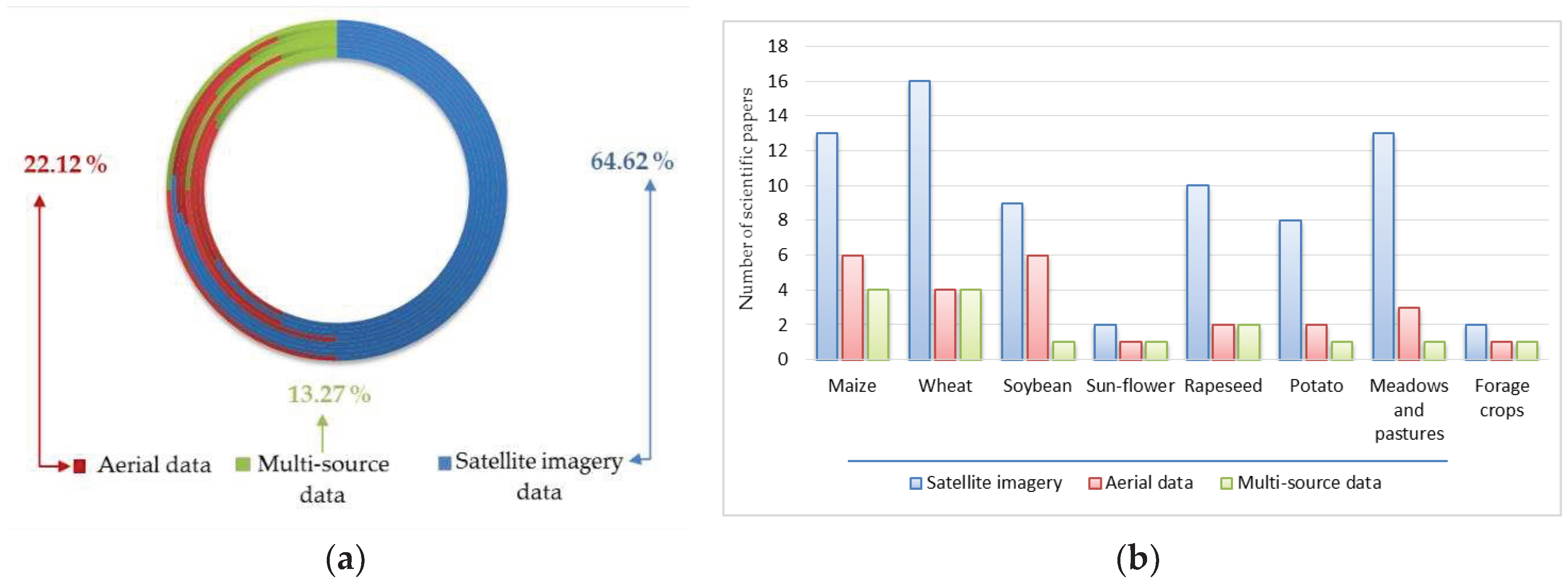
Figure 2.
Major sources of remote sensing satellite data used in agricultural studies: (a) Percent of free versus commercial data sources, from total publications; (b) The major remote sensing satellite data sources.
Figure 2.
Major sources of remote sensing satellite data used in agricultural studies: (a) Percent of free versus commercial data sources, from total publications; (b) The major remote sensing satellite data sources.
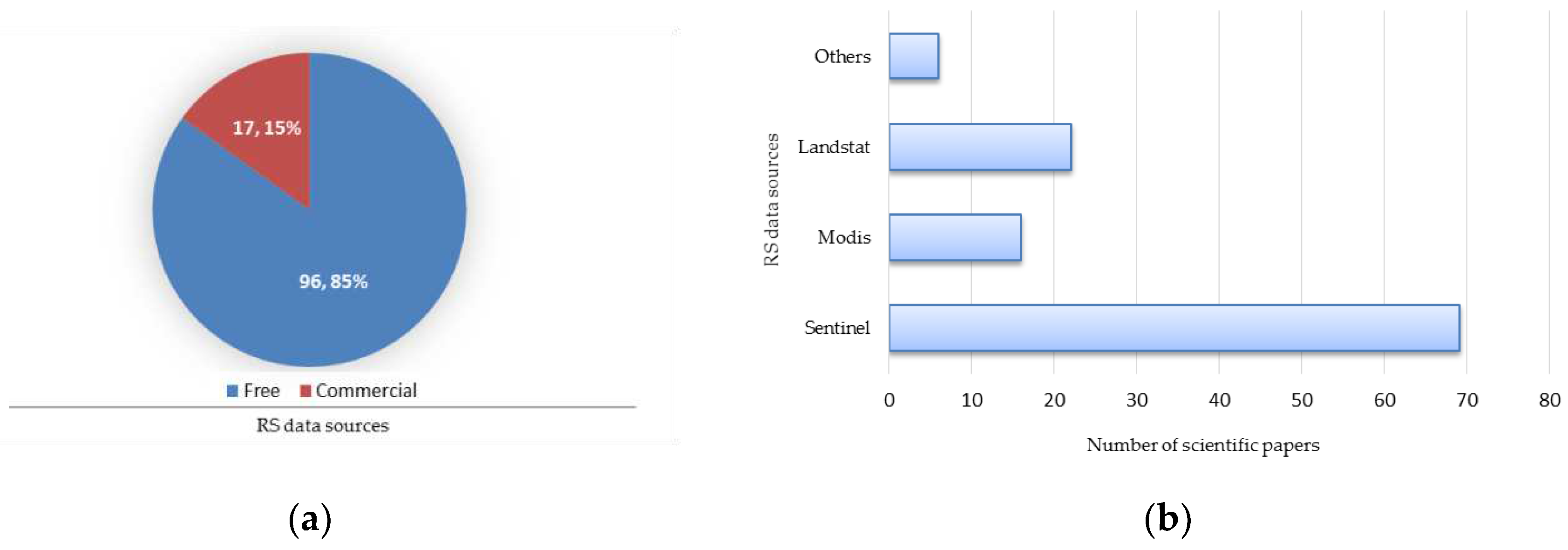
Table 6.
An extensive review of VIs used in rapeseed crop research.
| Country/ Region |
Satellite data used | Remote sensors used (if applicable) | Time span of the study | Computed index | Reference(s) |
|---|---|---|---|---|---|
| Spain, Germany, France | Sentinel-2 | LI-COR, LAI-2000, SPAD-502 | 2003-2004; 2006; 2007 | LAI, Chlorophyll Content | [57] |
| France | Sentinel-1 | LI-COR 3100 | 2014 | NDVI | [59] |
| Finland | Sentinel-2 | - | April - October 2016-2017 | NDVI | [69] |
| France | Sentinel-1&2 | - | January - July 2017 | LAI, MCARI, NDVI, S2REP, WDVI | [41] |
| France | Sentinel-1&2 | - | January - July 2017 | DOY, ID, IRECI, GNDVI, LAI, VV NDI, NDVI, PSSRa, REIP, SAVI etc. | [5] |
| Germany | Sentinel-1&2 LUCAS | - | 21 April – 19 May 2018 | NDYI | [72] |
| Germany | Landsat 8, OLI & Sentinel | - | 2018 | NDVI, NDYI | [86] |
| Belgium | Sentinel-1 Sentinel-2 |
- | 2018 | NDVI | [45] |
| Germany | - | UAV | 2019-2021 | NDVI, NDYI | [85] |
Table 7.
An extensive review of VIs used in potato crop research.
| Country/ Region |
Satellite data used | Remote sensors used (if applicable) | Time span of the study | Computed index | Reference(s) |
|---|---|---|---|---|---|
| Syria | - | FieldSPEC | 1997 | NDVI | [54] |
| Romania | - | Fieldscout equipment NDVI Meter | 2011 | NDVI | [90] |
| Switzerland | - | UAV, HandySpec Field | 2015 | NDVI | [88] |
| Japan | Sentinel-2A | - | 2016 | 82 indices: ARVI, CARI, CCCI, CRI 550, GDVI,GNDVI, GVMI, NDVI, SLAVI etc | [44] |
| The Netherlands | Sentinel-2 | - | 2016 | CCC, LAI, LCC, WDVI | [89] |
| Finland | Sentinel-2 | - | April to October 2016-2017 | NDVI | [69] |
| Belgium | Sentinel-2 | - | 2016-2018 | NDVI | [87] |
| UE | Sentinel-1 | - | 2018 | NDYI | [70] |
| Belgium | Sentinel-1 Sentinel-2 |
- | 2018 | NDVI | [45] |
| India | Sentinel-1&2 | - | 2019-2020 | NDVI | [91] |
Table 8.
An extensive review of VIs used in forage crop research.
| Type of meadows and pastures, as reported | Country/ Region |
Satellite data used | Remote sensors used (if applicable) | Time span of the study | Computed index | Reference(s) |
|---|---|---|---|---|---|---|
| Alfalfa | Spain, Germany, France | Sentinel-2 | LI-COR LAI-2000 SPAD-502 |
2003-2004, 2006, 2007 | LAI, Chlorophyll Content | [57] |
| Alfalfa | Saudi Arabia | Landsat-8 | Hay yield monitor data | October 2013 - May 2014 |
EVI, GRVI, GNDVI, LSWI, NDVI, SAVI, SR | [49] |
| Alfalfa | Saudi Arabia | CubeSat, Landsat-8, MODIS |
- | 2017 | LAI, NIR, REGFLEC-based LAI | [61] |
| Forage crops | Italy | Sentinel-2 | - | 28 February -30 June 2021 |
NDVI | [93] |
Table 9.
An extensive review of VIs used in meadows and pastures research.
| Type of agricultural land: meadows or pastures, as reported | Country/ Region |
Satellite data used | Remote sensors used (if applicable) |
Time span of the study | Computed index |
Reference |
|---|---|---|---|---|---|---|
| Pastures and arable land |
France | SPOT-5, Landsat and RADARSAT-2 | - | 2010 | NDVI, LAI, fCOVER | [103] |
| Pastures | Czech Republic |
MODIS | - | 2010-2011 | NDVI, PSRI | [101] |
| Meadows | France | MODIS | - | 2012-2014 | NDVI | [100] |
| Type of agricultural land: meadows or pastures, as reported |
Country/ Region |
Satellite data used |
Remote sensors used (if applicable) |
Time span of tde study |
Computed index |
Reference |
| Pastures and arable land |
Czech Republic |
Landsat-8, Land Parcel Identification System (LPIS) | - | 2013-2016 | NDVI, SR, SGI | [99] |
| Pastures | China | Landsat-7 ETM+, Landsat-8 OLI, Sentinel-2A MSI, MODIS | - | 2014-2015 June-August |
LAI | [104] |
| Pastures | Australia | Sentinel-2 | - | 2019-2020 | NDVI | 97 |
| Pastures | Belgium | Sentinel-1 A and B | - | April-July 2019 | SAR | [105] |
| Meadows | Czech Republic |
Sentinel-2 | - | 2015-2019 | FAPAR, FCOVER, LAI, CAB, CWC, NDVI | [98] |
| Meadows | Belgium | Sentinel-1&2 | - | 2018 | NDVI | [45] |
| Meadows | Italy | Sentinel-2 | - | 28 February -30 June 2021 |
NDVI | [93] |
| Meadows | Norway | Sentinel-2 | - | May 2019-October 2019 | SAVI | [70] |
| Meadows | Germany | Sentinel-2, Landsat-8, PlanetScope |
- | 2017-2020 | EVI | [106] |
| Meadows | Switzerland | Sentinel-2 | - | 2017-2019 | NDVI, EVI | [3] |
| Pastures | Ethiopia | Sentinel-2 | - | 2018 | NDVI, EVI | [102] |
| Meadows | Italy | Landsat-8, Sentinel-2, PlanetScope |
- | 2021 | EVI, GNDVI, GVMI, MSAVI, NBR, NDGI, NDMI, NDII, NDREI, NDVI, PSRI, RECI, RENDVI, RESI, RVI, SAVI, VARI, WDRVI | [96] |
Disclaimer/Publisher’s Note: The statements, opinions and data contained in all publications are solely those of the individual author(s) and contributor(s) and not of MDPI and/or the editor(s). MDPI and/or the editor(s) disclaim responsibility for any injury to people or property resulting from any ideas, methods, instructions or products referred to in the content. |
© 2023 by the authors. Licensee MDPI, Basel, Switzerland. This article is an open access article distributed under the terms and conditions of the Creative Commons Attribution (CC BY) license (http://creativecommons.org/licenses/by/4.0/).
Copyright: This open access article is published under a Creative Commons CC BY 4.0 license, which permit the free download, distribution, and reuse, provided that the author and preprint are cited in any reuse.


