
Submitted:
06 October 2023
Posted:
09 October 2023
You are already at the latest version
Abstract
Nowadays, the demand of agricultural production increase, Moreover, the rapid increase of the population in Egypt led to an increase in the demand for food, prompting the government to reclaim more desert lands. Such a study contributes to providing information that contributes to the promising optimization of land resources. This study carried out in an area south Egypt covering 386,171.04 hectares (ha). Remote sensed data were manipulated for defining the land cover/use features. Setting up DEM configures the network of natural drainage flows via the descending slopes. It was a guide for allocating micro dams as water harvesting sites as well as minimizing the runoff hazards and managing the priority of land use suitability versus flood hazards. Land cover/use units were defined as terrestrial irrigated areas of sequentially herbacous crops and permanent trees covering 1387.83 ha in levees; 1608.82 ha in point bar; 718.89 ha in bow bar and 23938.29 ha in alluvial plain. Terrestrial natural vegetation is dominated by xerophytes herbaceous in wadis (123533.56 ha). Terrestrial non-vegetated areas includes bare areas of rock land (98102.59 ha) and 67201.57 in bajada. Artificial non linear surfaces include buildings (5403.59 ha) and linear features include roads and railways (875.78 ha). Aquatic areas include artificial irrigation and drainage canals (1062.15 ha) and natural water body of River Nile course (2785.92 ha). Current land suitability for specific Land Utilization Types (LUTs) was assessed by matching soil attributes with the growth requirement of each LUT. Current land suitability can be improved by decreasing of salinity and framing practices. Accordingly, the land units can be potentially more profitable for increasing the ability of extra crops to be more productive. Old cultivated areas are the most profitable land cover/use units highly suitable (S1) for all LUTs comparing with other land cover categories.
Keywords:
land evaluation
; soil suitability
; South East Egypt
; remote sensed data
Introduction
Remote sensing imagery (RS) have been used widely for mapping crops (M. El-Sharkawy et al., 2016; M. M. El-Sharkawy et al., 2016; Farg et al., 2020). Satellite sensors produce imageries of high spatial features in a fast, precise and low-cost data over large areas for mapping soil and water quality, compared with classic techniques. It’s a perfect tool to assess land use/cover (Arafat et al., 2014; Elsharkawy et al., 2022a; Nabil et al., 2022). It can be used to realize an integration of maximizing the use of water and land resources based on a complementary view (AbdelRahman et al., 2022; Elsharkawy et al., 2022b; Saleh et al., 2021). South east of Egypt area and its outskirts receive a seasonal amount of surface runoff during the rainy season over the mountains in the, eastern side of the study area (Peel et al., 2007). Also, the available types of renewable energy can realize a successful management of this region for the agricultural land use. These natural elements can maximize the use of proposed land utilization types (LUTs). In addition to trace promising areas to be under development the study realizes a specific value of the old cultivated land. This inherited rural area should to be as a protectorate. According to Afify et al 2022, this old cultivated land of river Nile sediments should be protected as a cultural landscape being inherited agrobiodiversity (Afify et al., 2022). Setting up Digital Elevation Model was a beneficial base that generates landscape configuration to be a guide for delineating physiographic and land cover features and for tracing the runoff directions. (Evans, 2012), considered the DEM as a basic of geomorphometric analysis that reflect the existence of a relationship between landforms and some numerical parameters. The study area and its outskirts are seasonally receive a rainy precipitations over the catchment areas in the high lands that flow as surface runoff over the drainage channels capacity via descending slopes. The status can be managed to utilize these surface water at the basin outlets for increasing ground water recharge as well as avoiding the flush flooding hazards. According to (El Bastawesy et al., 2010) the Kom-Ombo area and its outskirts includes fracture system, which is particularly promising for bringing groundwater from the Nubian aquifer. Also, directions of deep seated fractures seem to control much of the Kom-Ombo graben structure east of the Nile. (Afify, 2009) stated that Egypt is located in the zone of aridic moisture regime with limited water resources (Abdel Rahman et al., 2022; Elsharkawy et al., 2022a). Performing a firm policy of building up assets and integrating experience for tracing extra water resources should be a profound part of our interests. Accordingly, the current study considered all these natural elements within a region includes suitable land for agricultural land use. This suitable land includes a network of available solar energy for generating electrical power. Also aligning the old cultivated River Nile sediments with easy excess for marketing and dealing beneficial activities. The processed and displayed data by Geographic Information Systems (GIS) resulting in interpreted spectral signatures of landscape features associated with specific soil taxa (Saleh et al., 2021). They can be used as a geo-data base to serve the extrapolation process when other area in the same region will be investigated (Elsharkawy et al., 2022b). The current work aims to update the spatial distribution of land cover classes and their suitability levels for the agricultural land use as well and to trace the promising areas for agricultural development. The main objective was to delineate land cover features and associated soils to trace the promising areas for agricultural land use in this unique region of promising natural elements.
Material and Methods
Study area
The study area situated in the southeastern Egypt, which includes part of River Nile alluvium with its eastern desert outskirts covering 386171.04 hectares. The coordinates of this area are latitude of 24°16'43.52"N and longitude of 32°53'24.01"E in the lower left corner, while in the upper left corner are latitude of 24°38'11.48"N and longitude of 32°55'26.40"E. In the upper right corner, the latitude is 24°44'12.33"N and the longitude is 33°43'13.15"E, while in the lower right corner, the latitude is 24°16'42.66"N and the longitude is 33°43'05.82"E (Figure 1).
Digital Elevation Model (DEM)
The produced DEM was manipulated as raster layer of pixel values that are corresponding to their associated elevations. This DEM was obtained from the active sensor database Advanced Space borne Thermal Emission and Reflection Radiometer (ASTER) of resolution 30 m. These data of ASTER GDEM v2 (version 2 of Global Digital Elevation Model) are available for the globe from the United States Geological Survey (USGS). The data were manipulated in conjunction with OLI Data to provide a better visualization of the landscape configuration in the region of the study area.
Remote sensing data
Landsat 8 of Operational Land Image (OLI) acquired in 2022 were manipulated for land cover classification. The multispectral bands have spatial resolution of 30 meters with spectral resolutions of Green (530-590 nm), Red (640 -670 nm), and Near-Infrared (850-880 nm). These data were merged with panchromatic band of 15 meters spatial resolution with spectral resolution of 500- 680 nm.
Geometric correction and image sub-setting of remote sensing data
Remote sensing data were geometrically corrected according to Universal Transverse Mercator (UTM) projection, zone 36 Spheroid and Datum are WGS 84. Sub scene were breached out to fit the located study area using the cartographic software of ERDAS Inc., (2010) to reduce the data space and required time for processing them.
Automated and visual land cover classification
Land cover classification based on recognizing the components of landscape features, using automated unsupervised classification performed into classes. The process depends on the natural groupings of pixels, which based on the clustering method of Iterative Self-Organizing Data Analysis Technique (ISODATA) algorithm of (ERDAS, 2010). The main roads, railways and water flowing canals were visually traced in shape file as linear, which were buffered as polygons to be calculated as areas. Land cover classes were defined according to the Land Cover Classification System (LCCS) by (Di Gregorio, 2005) and based on the physiographic features according to (Zinck and Valenzuela, 1990).
Naming geographic features
Naming geographic features of the study area based on topographic maps of scale 1: 50000, which were published by the Egyptian Land Survey Authority (1990).
Field work
Field work was started to check the preliminary interpretation map by different ground observations for confirming or revising the borders of land cover units and the land cover classes. For soil morphological study and sampling, seventeen soil profiles were selected to represent the land cover units using the Global Positioning System (GPS). Soil strata were described according to the nomenclature of Soil Survey Manual (Soil Science Division, 2017).
Laboratory analyses
For determining texture classes, particle size distribution was measured according to Sparks et al. (2020) using the pipette after removing salts and organic matter. Sodium hexametaphosphate was added as a dispersing agent. According to Nelson (1982), the contents of calcium carbonate were measured by the calcimeter, while gypsum was determined by precipitation with acetone.
In soil paste extract. Salinity was expressed as electrical conductivity (EC) according to (Carter and Gregorich, 2007). Soil pH in soil paste and exchangeable sodium percentage (ESP) were determined according to (Richard, 1954).
Land suitability assessment for agricultural land use
For the irrigated agriculture, land evaluation was carried out using the conversion tables as proposed by Sys et al. (1993) for arid and semi-arid regions for evaluating each land utilization type versus certain land cover class.
Results and Discussion
Setting up Digital Elevation Model (DEM)
Digital Elevation Model (DEM) was produced as a guide for defining corresponding elevations as 3-dimentional visualization in projections. The elevation intervals in this produced DEM are highly correlated with the defined physiographic units and their associated land cover fractures and soil attributes. Within the descending slopes landscape features are highly affected by their relative positions, which face variations of flush flooding action. The case reflects variability of erosion and sedimentation processes within the land configuration and via specific drainage pattern. These patterns link the catchment area in the high lands with the drainage basin in the low lands. Accordingly, DEM serves as a satisfactory overall view to be basis for understanding the best way for managing the land and water resources. (Rabah et al., 2017) stated that DEM is crucial to a wide range of surveying and civil engineering applications worldwide. It can be also used as a data source for mathematical analysis of the topography and landscape (Martinez Martinez and Muñoz, 2016). (Munar-Vivas and Martínez M, 2014) considered this DEM as a base for enhancing soil information as well as enhancing land evaluation. The study area and its outskirts are graphed by elevations range from 75 to 792 meters above sea level. This overall view configures the network of natural drainage flows westwards having impacts on the low laying cultivated lands. Accordingly, DEM (Figure 2) can be used as a guide for allocating micro dams as water harvesting sites and minimizing the runoff hazard. Also, can help for managing the priority of land use allocations versus these flood hazards considering the relationship between certain land unit and the required land utilization types
Defining land cover units and their spatial distributions
The defined land cover features were delineated as terrestrial vegetated area of irrigated agriculture-and natural vegetation. Non-vegetated areas iclude terrestrial artificial surfaces or aquatic ones as artificial or natural water bodies. They are listed in Table 1 and, mapped in Figure 3 and described as follows: artificial
1 Terrestrial vegetated area
1a Cultivated areas
These cultivated areas include irrigated cultivation, which are mostly managed under surface irrigation.of sequentially herbacous crops and permanently managed trees. This land cover class is covering 1387.83 hectares (ha) in Nile levees as 0.36%; 1608.82 ha in. Nile point bar as 0.42 %; 718.89 ha in bow bar as 0.19 % and 23938.29 ha in Nile alluvial plain as 6.20 percent (%) of the total area
1b-Natural vegetation
Natural vegetation includes xerophytes sparse herbaceous and shrubs in wadis covering 123533.56 ha as 31.99 %
2 Terrestrial non-vegetated area 2a Consolidated bare areas of rock land
This land cover class is covering 98102.59 ha (15.42 %). It is attributed by consolidated surfaces of hard rock.
2b Unconsolidated bare areas
This land cover class (67201.57 ha) in bajada as17.4 %. It is dominated by bare areas of gravelly soils with very local scattered herbaceous in riled landscape.
2c Artificial non linear surfaces
These non-linear surfaces represent the buildings of settlements or administrative affairs, which cover 5403.59 ha (1.40 %).
2d Linear surfaces
These linear surfaces were traced as lines that represen a nework of infrastructure including the main asphated roads and railways. They were bufferd considering each of their width to be calculated as areas in polygons that cover 875.78 ha as 0.23 %
3 Aquatic non-vegetated area
3a- Artificial water bodies
These artificial water bodies are a nework of flowing water in the satudy area as irrigation and drainage canals. They were traced and buffered as polygons covering 1062.15 as 27 %.
3b- Natural water bodies
This natural water body represents a locall allocated part of River Nile course in the study area that covers 2785.92 ha as 0.72 %
Land evaluation for agricultural use
In this study, Land evaluation define specific levels of soil managements for land use as land units rather than evaluating each individual soil profile. Suitability assessment based on evaluating each land cover unit for certain LUT to determine the most productive LUT in certain land cover unit. The purpose was to maximize the productivity in all the land units in the study area. The proses of performing land suitability legend based on managing irrigated agriculture in arid and semi-arid regions. Suitability classification was processed to define orders as suitable (S) or not suitable (N). These orders were classified as highly suitable (S1), moderately suitable (S2), marginally suitable (S3), currently not suitable (N1) and potentially not suitable (N2). This Land evaluation was assessed by matching the calculated ratings that based on soil attributes (Table 2) with the crop requirements as proposed by (Sys et al., 1993). The calculated ratings are soil depth, drainage, texture, calcium carbonate, gypsum, pH salinity and alkalinity. The land was evaluated for the LUTs that are traditionally cropped as terrestrial cultivation and mainly managed under surface irrigation. These collective LUTs were considered to satisfy the requirements in Egypt for edible and fodder crops as well as oil seed crops.
1 Current land suitability of certain land cover class for specific LUTs
The current land suitability classes for those LUTs are shown in Table 3. Each land cover class was evaluated for different LUTs that include Alfalfa, barley, beans, cabbage, carrot, cowpea, green pepper, maize, onion, pea, potato, sesame soya tomato, sorghum sweet potato wheat, sunflower tomato, date palm, citrus, guava, mango.
The current land suitability classes for irrigated agriculture in levees and bow bars are highly suitable (S1) for all LUTs, while irrigated agriculture in point bars are S1.for most of LUTs but Moderately suitable (S2) for, beans soya wheat. Irrigated agriculture in alluvial plain is S1 for most LUTs but is S2 for beans potato, sesame, soya citrus, mango, while is marginally suitable (S3) for carrot. Areas of natural vegetation in wadis (partly cultivated) are S1 for alfalfa and barley sesame, S2 for. cabbage beans, cowpea, maize, onion pea, potato, sorghum, sunflower, sweet potato, wheat, date palm guava mango, green pepper, tomato carrot and citrus, while are N1 for beans and soya. Bare area in bajada is S2 for Alfalfa, cowpea, maize, sesame, sorghum, sunflower, wheat, date palm; while is S3 for barley, cabbage, green pepper onion, pea potato, sweet potato, tomato, guava, citrus and mango but are currently not suitable (N1) for beans, carrot, and soya. Bare areas in pediplain are S3 for barley, while are N1for other crops. Bare areas in rock land are potentially not suitable (N2) for all crops.
2 Current and Potential land suitability
Current land suitability of the virgin land can be improved by correcting the levels of Limitations, are mainly concerning the limitations of salinity and sodicity.
Accordingly, the Land units can be potentially more profitable for most of increasing the ability of extra crops to be more productive. Potential land suitability classes for Irrigated griculture in Nile levees and bow bars are S1.for all LUTs. Irrigated griculture in Nile point bars are S1.for most of LUTs but S2 for, beans soya and wheat. Irrigated griculture in Nile Alluvial plain is S1 for most LUTs but is S2 for beans potato, sesame, soya citrus and mango, while is (S3) for carrot. Areas of natural vegetation in wadis (partly cultivated) are S1 for alfalfa, barley, cabbage, sesame, onion and sesame, while are S2 for beans, cowpea maize, pea, potato, sorghum, sunflower, sweet potato, wheat, date palm guava and mango. They are S3 for tomato carrot, green pepper and citrus but are N1 for soya. Bare area in bajada is S2 for Alfalfa, beans, cowpea, maize, onion, pea, potato, sesame, sorghum, sunflower, wheat, date palm; mango and citrus, while is S3 for barley, cabbage, carrot green pepper, sweet potato, tomato, guava, but are currently not suitable (N1) for soya. Bare areas in pediplain are S3 for barley, cabbage, cowpea, maize, potato and wheat, while are N1 for other crops. Bare areas in rock land are potentially not suitable (N2) for all crops. Potential land suitability classes for LUTs are shown in Table 4.
Recommendations
1-The study area was situated in a unique region with natural element including relief of seasonal flush flooding and available renewable energy. These natural resources can be managed for maximizing the agricultural development in such region.
2- DEM reflect an overall view that can help as a base for earthwork concerning the network of natural drainage flows eastwards with erosional and depositional processes. These processes have impacts on the low laying lands. Accordingly, DEM can be used as a guide for allocating micro dams as water harvesting sites and minimize the runoff hazard. The case can help managing the priority of land use allocations versus the flood hazards.
3-LUTs were proposed as edible and fodder crops as well oil seed crops to fit the need of food security and as economic importance in industry.
4-The current land suitability can be improved as potential land suitability one by correcting salinity and sodicity limitations. By cultivating specific LUT in certain more suitable land unit, all land units will be more profitable.
References
- Abdel Rahman, M.A.E. , Saleh, A.M., Elsharkawy, M.M., Farg, E., Moustafa;, M., Abutaleb, K., Arafat, S.M., 2022. Geomatics-Based Mapping of Hydraulic Soil Properties for Agricultural Management. Ann. Agric. Sci. Moshtohor 60, 225–238. [CrossRef]
- AbdelRahman, M.A.E. , Farg, E., Saleh, A.M., Sayed, M., Abutaleb, K., Arafat, S.M., Elsharkawy, M.M., 2022. Mapping of soils and land-related environmental attributes in modern agriculture systems using geomatics. Sustain. Water Resour. Manag. 8, 116.
- Afify, A.A. , 2009. Land resources evaluation of the paleodarainage delta in western desert of egypt using remote sensing data. Egypt. J. Remote Sens. Sp. Sci. 12, 3–26.
- Afify, A.A. , El Tabey, H., Abdel Moneim A, E.T., Al-Gammal, I.A., Afify, 2022. Monitoring and evaluating the attributes of retreated cultivated land under urban encroachment in South Giza Governorate, Egypt. Sci. J. Agric. Sci. 4, 11–23.
- Arafat, S.M., Afify, A.A., Nagwan, M.A., Elsharkawy, M.M., 2014. Change detection of land use/land cover categories in the Nile Delta region using remote sensing and GIS, in: SPIE Remote Sensing. in Proceedings of the SPIE Remote Sensing and SPIE Security, Amsterdam, Netherland, p. vol. 9239.
- Carter, M.R. , Gregorich, E.G., 2007. Soil sampling and methods of analysis (eds). Canadian Society of Soil Science, Lewis Publisher, CRC Press. CRC press.
- Di Gregorio, A. , 2005. Land cover classification system: classification concepts and user manual: LCCS. Food & Agriculture Org.
- Egyptian General Survey Authority (EGSA), 2006. Topographic maps of scale 1: 50,000. Egyptian General; Survey Authority, Cairo, Egypt.
- El-Sharkawy, M. , Sheta, A., Abd El-Wahed, M.S., Arafat, S.M., El Behiery, O.M., 2016. Precision agriculture using remote sensing and GIS for peanut crop production in arid land. Int. J. Plant Soil Sci. 10, 1–9.
- El-Sharkawy, M.M. , Sheta A. S., Arafat, S.M., Abd El-Wahed, M.S., 2016. Precision agriculture using advanced remote sensing techniques for peanut crop in Arid Land. J. Hyperspectral Remote Sens. 6, 72–81.
- El Bastawesy, M. , Faid, A., Gammal, E.S. El, 2010. The Quaternary development of tributary channels to the Nile River at Kom Ombo area, Eastern Desert of Egypt, and their implication for groundwater resources. Hydrol. Process. 24, 1856–1865.
- Elsharkawy, M.M. , Nabil, M., Farg, E., Arafat, S.M., 2022a. Impacts of land-use changes and landholding fragmentation on crop water demand and drought in Wadi El-Farigh, New Delta project, Egypt. Egypt. J. Remote Sens. Sp. Sci. 25, 873–885.
- Elsharkawy, M.M. , Sheta, A.E.A.S., D’Antonio, P., Abdelwahed, M.S., Scopa, A., 2022b. Tool for the Establishment of Agro-Management Zones Using GIS Techniques for Precision Farming in Egypt. Sustainability 14. [CrossRef]
- ERDAS, I. , 2010. Earth resources data analysis system. ERDAS Inc. Atlanta, Georg. 628.
- Evans, I.S. , 2012. Geomorphometry and landform mapping: What is a landform? Geomorphology 137, 94–106.
- Farg, E. , Abutaleb, K., Arafat, S., Elsharkawy, M.M., Nabil, M., 2020. Assessment of Sentinel-2 data capabilities for vegetation physiological parameters retrieving in the Nile Delta. Biosci. Res. 17, 467–478.
- Martinez Martinez, L.J. , Muñoz, N.A.C., 2016. Digital elevation models to improve soil mapping in mountainous areas: case study in Colombia. Geopedology An Integr. Geomorphol. Pedol. soil Landsc. Stud. 377–388.
- Munar-Vivas, O.J. , Martínez M, L.J., 2014. Relief parameters and fuzzy logic for land evaluations of mango crops (Mangifera indica L.) in Colombia. Agron. Colomb. 32, 238–245.
- Nabil, M. , Farg, E., Arafat, S.M., Aboelghar, M., Afify, N.M., Elsharkawy, M.M., 2022. Tree-fruits crop type mapping from Sentinel-1 and Sentinel-2 data integration in Egypt’s New Delta project. Remote Sens. Appl. Soc. Environ. 27, 100776. [CrossRef]
- Peel, M.C. , Finlayson, B.L., McMahon, T.A., 2007. Updated world map of the Köppen-Geiger climate classification. Hydrol. Earth Syst. Sci. 11, 1633–1644. [CrossRef]
- Rabah, M. , El-Hattab, A., Abdallah, M., 2017. Assessment of the most recent satellite based digital elevation models of Egypt. NRIAG J. Astron. Geophys. 6, 326–335.
- Richard, L.A. , 1954. Diagnosis and Improvement of Saline and Alkaline Soils. Agricultural Handbook No. 60. US Dep. Agric. https//www. ars. usda. gov/pacificwest-area/riverside-ca/us-salinity-laboratory/docs/handbook-no-60/(accessed 26.27. 2017).
- Saleh, A.M. , Elsharkawy, M.M., AbdelRahman, M.A.E., Arafat, S.M., 2021. Evaluation of Soil Quality in Arid Western Fringes of the Nile Delta for Sustainable Agriculture. Appl. Environ. Soil Sci. 2021, 1434692. [CrossRef]
- Soil Science Division, U. , 2017. Soil survey manual. USDA Handb. 18.
- Sys, C. , Van Ranst, E., Debaveye, J., Beernaert, F., 1993. Land Evaluation. Part III: crop requirements. Agricultural Publications n° 7, GADC, Brussels, Belgium, 1993, 191 p.
- Zinck, J.A. , Valenzuela, C.R., 1990. Soil geographic database: structure and application examples. ITC J. 270–294.
Figure 1.
Location map of the study area.
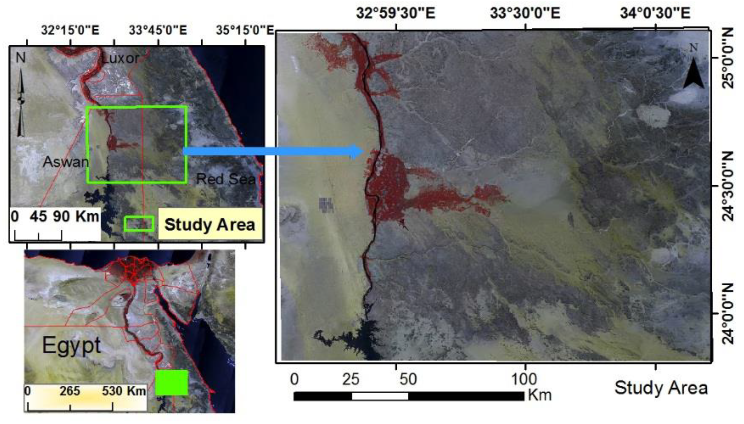
Figure 2.
DEM and slope directions in the study area and its outskirts.
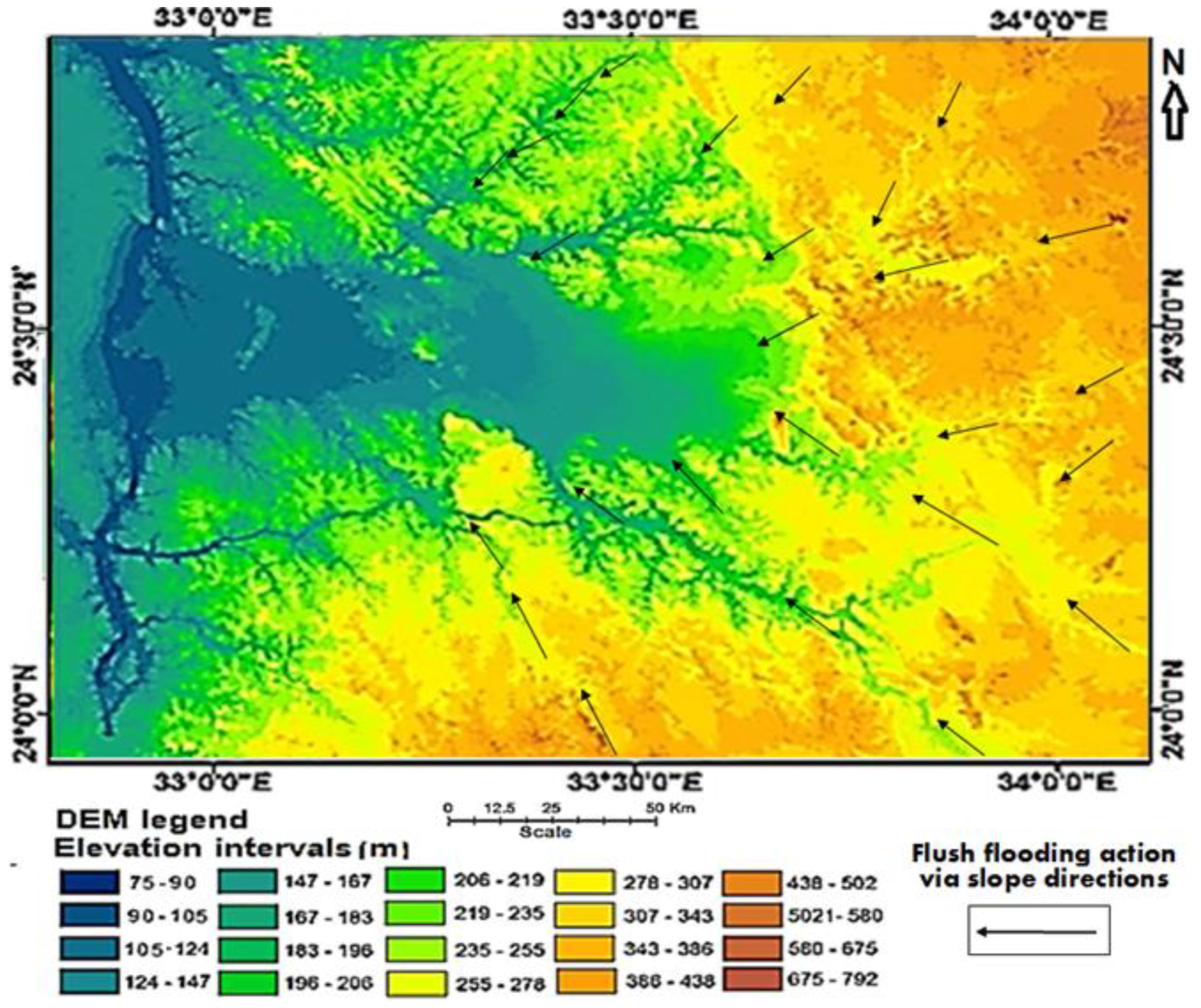
Figure 3.
The spatial distribution of land cover units in the study area.
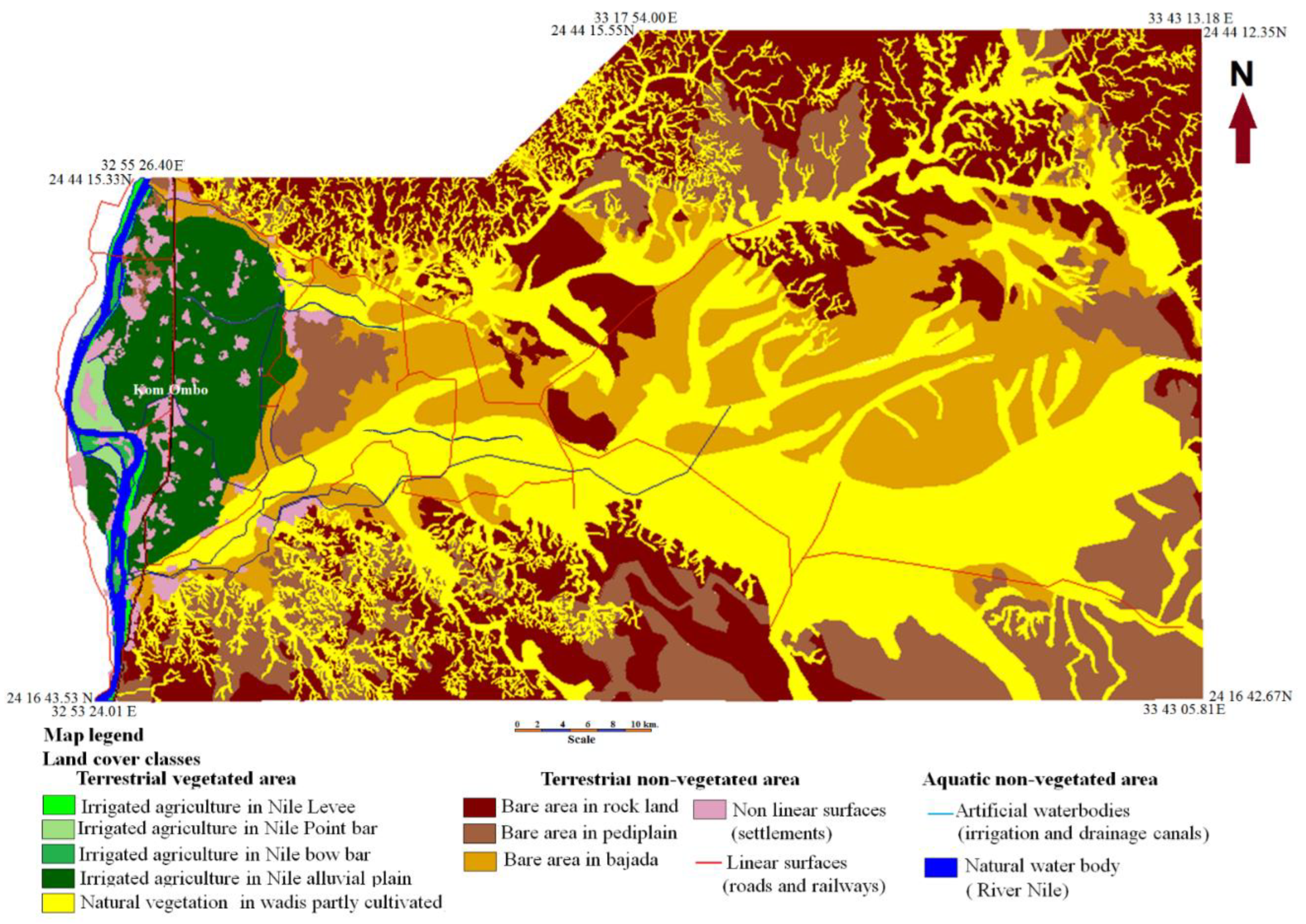

Table 1.
Land cover classes and their spatial distribution in the study area.
| Land cover classes | Area per hectares | Percent (%) |
|---|---|---|
| Irrigated agriculture in Nile Levee | 1387.83 | 0.36 |
| Irrigated agriculture in Nile point bar | 1608.82 | 0.42 |
| Irrigated agriculture in Nile bow bar | 718.89 | 0.19 |
| Irrigated agriculture in Nile alluvial plain | 23938.29 | 6.20 |
| Natural vegetation in wadis partly cultivated | 123533.56 | 31.99 |
| Bare area in rock land | 98102.59 | 25.4 |
| Bare area in pediplain | 59552.04 | 15.42 |
| Bare area in bajada | 67201.57 | 17.4 |
| Non linear surfaces (setllements) | 5403.59 | 1.40 |
| Linear surfaces (roads and railways) | 875.78 | 0.23 |
| Artificial waterbodies (irrigation and drainage canals) | 1062.15 | 0.27 |
| Natural water body ( River Nile) | 2785.92 | 0.72 |
| Total area | 386171.04 | 100 |
Table 2.
Soil chemical and physical analyses in land cover units.
| phyhsiographic units | Profile No. | Depth (cm) | Gravel %(vv) | Particle size distribution | Modified Texture class | CaCO3 g/kg. | CaSO4 g/kg. | pH | EC | ESP | ||
| Sand | Silt | Clay | ||||||||||
| Irrigated agriculture in Nile levee | 8 | 0 - 20 | - | 39.2 | 20.7 | 40.1 | C | 13.2 | 8.4 | 7 | 0.9 | 2.9 |
| 20 - 65 | - | 42 | 31.2 | 26.8 | L | 14.2 | 9.4 | 8 | 1 | 4.8 | ||
| 65 - 120 | - | 46.7 | 30.1 | 23.2 | L | 17.5 | 8.8 | 8 | 0.8 | 3.9 | ||
| 120 - 150 | - | 28.7 | 35.2 | 36.1 | CL | 11.6 | 7.9 | 8 | 1 | 5.1 | ||
| 17 | 0 - 25 | - | 30.7 | 34.2 | 35.1 | CL | 12.2 | 8.9 | 8 | 0.7 | 3.9 | |
| 25 - 65 | - | 47.9 | 29.5 | 22.6 | L | 14.3 | 7.4 | 8 | 0.8 | 2.8 | ||
| 65 - 85 | - | 63.9 | 20.3 | 15.8 | SL | 19.5 | 8.3 | 8 | 0.9 | 2.9 | ||
| 85 - 150 | - | 33.9 | 31.1 | 35 | L | 17.6 | 5.9 | 8 | 1 | 4.7 | ||
| Irrigated agriculture in Nile point bar | 6 | 0 - 30 | - | 50.8 | 27.6 | 21.6 | L | 19.4 | 3.4 | 8 | 1.1 | 4.9 |
| 30 – 75 | - | 31.1 | 33.4 | 35.5 | CL | 17.5 | 9.4 | 8 | 1 | 3.4 | ||
| 75- 100 | - | 84.3 | 7.3 | 8.4 | LS | 16.7 | 4.8 | 8 | 0.8 | 3.8 | ||
| 100- 150 | - | 82.1 | 8.2 | 9.7 | LS | 18.6 | 5.9 | 8 | 0.9 | 2.9 | ||
| 7 | 0 - 30 | - | 74.9 | 9.9 | 15.2 | SL | 21.2 | 8.4 | 8 | 0.8 | 4.1 | |
| 30 - 85 | - | 49.9 | 26.7 | 23.4 | L | 26.1 | 9.8 | 8 | 0.9 | 4.1 | ||
| 85 - 150 | - | 86.7 | 6.2 | 7.1 | LS | 12.5 | 8.1 | 8 | 0.7 | 4.2 | ||
| Irrigated agriculture in Nile bow bar | 4 | 0 - 30 | - | 38.3 | 19.8 | 41.9 | C | 18.8 | 5.9 | 8 | 1 | 3.8 |
| 30 – 60 | - | 45.1 | 30.5 | 24.4 | L | 17.4 | 6.8 | 8 | 1.1 | 4.3 | ||
| 60 - 100 | - | 69.9 | 14.7 | 15.4 | SL | 20.4 | 7.3 | 8 | 0.8 | 3.1 | ||
| 100- 150 | - | 65.8 | 16.5 | 17.7 | SL | 21.5 | 8.5 | 8 | 1 | 6. 2 | ||
| 5 | 0 - 30 | - | 36.9 | 31.1 | 32 | CL | 14.9 | 9. 4 | 8 | 0.8 | 6.8 | |
| 30 – 80 | - | 39.8 | 29.9 | 30.3 | CL | 16.8 | 6.4 | 8 | 0.9 | 6.7 | ||
| 80 - 100 | - | 74.9 | 11.3 | 13.8 | SL | 30.8 | 7.3 | 8 | 0.8 | 5.9 | ||
| 100- 150 | - | 37.9 | 30.6 | 31.5 | CL | 24.2 | 4.7 | 8 | 1 | 5.8 | ||
| Irrigated agriculture in Nile alluvial plain | 1 | 0 - 25 | - | 38.3 | 20.8 | 40.9 | C | 11.8 | 3.8 | 7 | 1.1 | 3.8 |
| 25 - 50 | - | 30.2 | 20.2 | 49.6 | C | 19.4 | 10.3 | 7 | 1.3 | 3.9 | ||
| 50 - 70 | - | 16.2 | 40.9 | 42.9 | C | 30.8 | 7.2 | 8 | 0.8 | 6.1 | ||
| 70-150 | - | 40.2 | 19.6 | 40.2 | C | 22.2 | 9. 3 | 8 | 1.4 | 5.6 | ||
| 2 | 0 - 20 | - | 36.7 | 18.2 | 45.1 | C | 18.8 | 6.8 | 7 | 1 | 6.9 | |
| 20 - 50 | - | 29.5 | 19.4 | 51.1 | C | 19.9 | 7.6 | 8 | 0.9 | 8.6 | ||
| 50 - 80 | - | 33.2 | 18.3 | 48.5 | C | 32.8 | 6.5 | 8 | 0.8 | 7.9 | ||
| 80 - 150 | - | 34.8 | 17.8 | 47.4 | C | 20.2 | 8. 7 | 8 | 1.1 | 5.8 | ||
| 3 | 0 - 20 | - | 39.5 | 16.3 | 44.2 | C | 28.8 | 8. 7 | 7 | 7.1 | 1.5 | |
| 25 – 70 | - | 36.2 | 19.7 | 44.1 | C | 29.9 | 9.8 | 8 | 7.9 | 1.1 | ||
| 70 - 85 | - | 28.1 | 34.5 | 37.4 | CL | 12.8 | 8.5 | 7 | 7.2 | 0.9 | ||
| 85 - 150 | - | 39.5 | 16.3 | 44.2 | C | 21.7 | 6.9 | 8 | 7.1 | 0.9 | ||
| Natural vegetation in wadis partly cultivated | 9 | 0-25 | 5 | 77.1 | 10.8 | 12.1 | SG, SL | 12.3 | 33.8 | 7 | 1.1 | 2.9 |
| 25-80 | 5 | 63.9 | 14.2 | 21.9 | SG, CL | 15.4 | 49.3 | 8 | 2.3 | 4.1 | ||
| 80-100 | 10 | 82.7 | 9.6 | 7.7 | SG, LS | 13.2 | 37.8 | 7 | 2.6 | 2.4 | ||
| 100-150 | 5 | 73.1 | 12.4 | 14.5 | SG, SL | 14 | 54.2 | 8 | 1.9 | 12 | ||
| 10 | 0-20 | 10 | 70 | 14.3 | 15.7 | SG, SL | 13.4 | 30.7 | 7 | 1.8 | 5.4 | |
| 20-75 | 10 | 47.1 | 28.9 | 24 | SG, SCL | 14.6 | 45.1 | 8 | 2.5 | 5.2 | ||
| 75-120 | 15 | 81.8 | 9.5 | 8.7 | G, LS | 12.5 | 36.9 | 7 | 2.3 | 6.1 | ||
| 11 | 0-30 | 10 | 72.2 | 14.3 | 13.5 | SG, SL | 15.7 | 40.7 | 7 | 1.9 | 5.3 | |
| 30-85 | 5 | 48.1 | 27.6 | 24.3 | SG, SCL | 16.2 | 42.5 | 8 | 3.1 | 4.3 | ||
| 85-100 | 10 | 57.2 | 21.2 | 21.6 | SG, SCL | 13.7 | 55.9 | 8 | 2.1 | 5.1 | ||
| 12 | 0-25 | 10 | 43.1 | 32.4 | 24.5 | SG, L | 12.6 | 43.8 | 7 | 2.2 | 4.7 | |
| 25-75 | 5 | 44.9 | 26.1 | 29 | SG, SCL | 10 | 44.3 | 8 | 1.8 | 9.7 | ||
| 80-100 | 10 | 42.1 | 27.1 | 30.8 | SG, SCL | 11 | 47.8 | 7 | 3.7 | 3.9 | ||
| 100-150 | 5 | 71.1 | 13.1 | 15.8 | SG, SL | 13.1 | 39.8 | 8 | 1.1 | 4.5 | ||
| Bare area in pediplain | 15 | 0-15 | 15 | 82.8 | 9 | 8.2 | GLS | 99 | 104.1 | 8 | 11 | 11 |
| 15-45 | 15 | 76.8 | 12.3 | 10.9 | GSL | 40.2 | 106.3 | 8 | 14 | 16 | ||
| > 45 | Bed rock of sandstone | |||||||||||
| 16 | 0-20 | 10 | 84.3 | 8.5 | 7.2 | SGLS | 117.8 | 99.1 | 8 | 15 | 9.1 | |
| 20-45 | 25 | 82.9 | 7.6 | 9.5 | GLS | 64.2 | 42.1 | 8 | 16 | 16 | ||
| > 45 | Bed rock of sandstone | |||||||||||
| Bare area in bjada | 13 | 0-20 | 15 | 58.2 | 21.3 | 20.5 | GS, CL | 42 | 45.8 | 8 | 3.3 | 5.4 |
| 20-45 | 25 | 67.9 | 17.7 | 14.4 | GSL | 59.4 | 98.5 | 8 | 4.7 | 6.7 | ||
| 45-85 | 20 | 71.9 | 11.7 | 16.4 | GSL | 18.1 | 48.6 | 8 | 3.9 | 12 | ||
| 85-150 | 30 | 81.6 | 9.6 | 8.8 | GLS | 15 | 80 | 8 | 5.1 | 6.9 | ||
| 14 | 0-25 | 15 | 70.3 | 13.4 | 16.3 | GSL | 39.4 | 45.1 | 7 | 2.7 | 5.1 | |
| 25-50 | 10 | 67.2 | 17.3 | 15.5 | SG, SL | 22 | 102.4 | 8 | 2.4 | 3.5 | ||
| 50-85 | 10 | 46.1 | 29.6 | 24.3 | SG, SCL | 50.5 | 43.5 | 7 | 3.6 | 3.9 | ||
| 85-120 | 15 | 69.5 | 13.8 | 16.7 | GSL | 10.2 | 73.5 | 8 | 4.1 | 4.8 | ||
Where: C = clay; CL = clay loam; SL = sandy loam; LS = loamy sand; SG = slightly gravely; SCL = sand clay loam; SL = sandy loam; LS = loamy sand and vv = volume of void-space.
Table 3.
Current land suitability of certain land cover class for specific LUTs.
| Land cover class | Crops | Land suitability |
|---|---|---|
| Irrigated griculture in Nile levees and bow bars | Alfalfa, barley, beans, cabbage, carrot, owpea. green pepper, maize, onion, pea, potato, sesame, soya tomato, sorghum, sweet potato wheat, sunflower, tomato, date palm, citrus, guava and mango | Highly suitable (S1) |
| Irrigated griculture in Nile point bar | Alfalfa, barley, cabbage, carrot, cowpea, green pepper, maize, onion, pea, potato, sesame, sorghum, sunflower, sweet potato, tomato, date palm, citrus, guava and mango | Highly suitable (S1) |
| Beans, soya and wheat | Moderately suitable (S2) | |
| Irrigated griculture in Nile alluvial plain | Alfalfa, barley, cabbage, cowpea, green pepper, maize, onion, pea, sorghum, sunflower, sweet potato tomato, wheat, date palm and guava | Highly suitable (S1) |
| Beans, potato, sesame, soya citrus, and mango | Moderately suitable (S2) | |
| Carrot | Marginally suitable (S3) | |
| Natural vegetation in wadis partly cultivated | Alfalfa, Barley and sesame | Highly suitable (S1) |
| Cabbage, beans, cowpea, maize, onion, pea, potato, sorghum, sunflower, sweet potato, wheat, date palm, guava and mango | Moderately suitable (S2) | |
| Green pepper, tomato, carrot and citrus | Marginally suitable (S3) | |
| beans and soya | N1 | |
| Bare area in bajada | Alfalfa, cowpea, maize, sesame, sorghum, sunflower, wheat and date palm | Moderately suitable (S2) |
| Barley, cabbage, green pepper, onion, pea, potato, sweet potato, tomato guava, citrus and mango | Marginally suitable (S3) | |
| Beans, carrot and soya | N1 | |
| Bare area in pediplain | Barley | Marginally suitable (S3) |
| Other crops | N1 | |
| Bare area in rock land. | All crops | N2 |
Table 4.
potential land suitability of certain land cover class for specific LUTs.
| Land cover class | Crops | Land suitability |
|---|---|---|
| Irrigated agriculture in Nile levees and bow bars | Alfalfa, barley, beans, cabbage, carrot, cowpea, green pepper, maize, onion, pea, potato, soya tomato, sweet potato, sesame, sorghum, sunflower, tomato, wheat, date palm, citrus, guava and, mango | Highly suitable (S1) |
| Irrigated agriculture in Nile point bars | Alfalfa, barley, cabbage, carrot, cowpea, green pepper, maize, onion, pea, potato, sesame, sorghum, sunflower, sweet potato, tomato, date palm, citrus, guava and mango | Highly suitable (S1) |
| Beans, soya and wheat | Moderately suitable (S2) | |
| Irrigated agriculture in Nile alluvial plain | Alfalfa, barley, cabbage, cowpea, green pepper, maize, onion, pea, potato, sesame, sorghum, sunflower, soya, sweet potato, tomato, wheat, date palm and guava. | Highly suitable (S1) |
| Beans, potato, soya, citrus and mango | Moderately suitable (S2) | |
| Carrot | Marginally suitable (S3) | |
| Natural vegetation in wadis partly cultivated | Alfalfa, Barley, cabbage, sesame, onion and sesame | Highly suitable (S1) |
| Beans, cowpea, maize, pea, potato, sorghum, sunflower, sweet, potato, wheat, date palm, guava and mango | Moderately suitable (S2) | |
| Tomato, carrot, green pepper and citrus, | Marginally suitable (S3) | |
| Soya | N1 | |
| Bare area in bajada | Alfalfa, beans, cowpea, maize, onion, pea, potato, sesame, sorghum, sunflower, wheat, citrus date palm, mango and citrus | Moderately suitable (S2) |
| Barley, cabbage, carrot, green pepper, sweet potato, tomato and guava. | Marginally suitable (S3) | |
| Soya | N1 | |
| Bare area in pediplain | Barley, cabbage, cowpea, maize, potato and wheat. | Marginally suitable (S3) |
| Other crops | N1 | |
| Bare area in rock land | All crops | N2 |
Disclaimer/Publisher’s Note: The statements, opinions and data contained in all publications are solely those of the individual author(s) and contributor(s) and not of MDPI and/or the editor(s). MDPI and/or the editor(s) disclaim responsibility for any injury to people or property resulting from any ideas, methods, instructions or products referred to in the content. |
© 2023 by the authors. Licensee MDPI, Basel, Switzerland. This article is an open access article distributed under the terms and conditions of the Creative Commons Attribution (CC BY) license (http://creativecommons.org/licenses/by/4.0/).
Copyright: This open access article is published under a Creative Commons CC BY 4.0 license, which permit the free download, distribution, and reuse, provided that the author and preprint are cited in any reuse.


