Submitted:
25 September 2023
Posted:
25 September 2023
You are already at the latest version
Abstract
In several Indonesian tropical cities, such as Makassar City, frequent flooding during the peak rainy season poses a significant challenge. This study seeks to address this issue by devising effective policies to reduce flood exposure. The main obstacle lies in accurately determining the flood inundation area. To overcome this, the study utilizes multiple satellite data sources on a cloud platform, integrating them with land use data, and DEM data, aligning these with the local government's urban land use plan and existing drainage networks. The research aims to quantify the affected area, identify the predominant inundated land cover, and assess the efficiency of Makassar's drainage system and urban land use plan. The study reveals that an uncoordinated drainage system in the Tamalanrea, Biringkanaya, and Mangala sub-districts results in severe flooding, encompassing a total area of 35.28 km². The most affected land use type is cultivation, constituting approximately 43.5% of the flooded area. Furthermore, 82.26% of the urban land use plan, covering 29.02 km², is submerged. It is imperative for the local government and stakeholders to prioritize the enhancement of drainage systems and urban land use plans, particularly in low-lying and densely populated regions
Keywords:
Flood detection
; Satellite imagery
; drainage
; urban land use plan
; land cover
; slope
; elevation
1. Introduction
The Flooding is considered to be one of the most destructive natural disasters and the most damaging in developing countries due to the low level of protection[1]. Several cities in Indonesia, including Makassar City, experience flooding every year during the monsoon season. A devastating flood inundated almost all regions of Makassar City, peaking on February 13, 2023. The flood affected about 3,344 houses in 19 villages, housing 9,167 people or 2,695 families, according to a field survey by the Makassar Municipal Disaster Mitigation Board (BPBD), South Sulawesi[2].
Makassar City is an industrial city that supplies goods in East Indonesia as it has become the largest city in the eastern part of Indonesia. The position of Makassar City is extremely important to support the economic growth of Indonesia[3]. Therefore, disaster management in terms of policy recommendation is important to develop. However, a few studies have been conducted on the flood in Makassar. Widodo et al. found a high risk of flood increase due to land use change in the Makassar neighborhood region[4]. Musliadi et al. modeled the flood depth of the Tallo watershed in Makassar using the Log Pearson type III method from rainfall data[5]. Thoban and Hizbaron conducted research with the Spatial Multi-Criteria Evaluation (SMCE) to find the resilience level of the Makassar community to flood[6]. No studies are comparing the actual flood inundation area, drainage distribution, and urban land use plan of Makassar City.
The main objective of this study is to measure the actual flood-inundated area and promote a policy recommendation. Thus, the local government will be able to design an appropriate policy to increase the resilience of the community from the annual flood. In this study, the latest technology in remote sensing and geographic information systems has been proposed. Google Earth Engine (GEE) is a powerful cloud-based platform[7]. GEE can be used in detecting the actual flood as it provides access to a large amount of satellite imagery and geospatial data sets from various sources and several researchers have conducted flood research utilizing GEE data base [8,9]. Moreover, it is a cloud based platform that provides high performance computing capabilities, offers a wide range of image processing functions and algorithms that can be applied to satellite data, time series analysis that can compare image before and after flood, integration with auxiliary data[7]. Therefore, GEE has been used in this study because it has the potential to provide valuable insights and to support evidence-based decision-making for flood-related policies and interventions.
Synthetic Aperture Radar (SAR) from the cloud-based dataset was utilized to detect the flood due to its capability because it is impossible to receive cloud-free images during rainy seasons [10,11,12,13]. SAR is not affected by cloud cover, fog, or atmospheric conditions that can limit the usability of optical images during cloudy or rainy periods[11]. Moreover, it can penetrate through clouds and capture reliable data regardless of weather conditions event at night time, ensuring continuous monitoring capability and can penetrate through vegetation to a certain extent and capture the underlying surface, including flooded areas[13,14]. These capabilities are beneficial when analyzing flood extent in densely vegetated regions where optical images may be obstructed by the vegetation canopy[11,14]. Moreover, it is sensitive to the roughness of the water surface, allowing for the differentiation between flooded areas and non-flooded areas based on the backscattering properties of water[11]. This sensitivity can aid in the accurate mapping of flood extents. SAR satellites often have shorter revisit times compared to optical satellites, which enables frequent monitoring and tracking of flood dynamics [15,16]. Hence, this capability is valuable for assessing flood progression, identifying temporal changes, and supporting timely decision-making. However, it is important to note that SAR imagery also has some limitations. Interpretation of SAR images may require specialized expertise due to the complex radar backscatter signals and speckle noise, and the data can also have lower spatial resolution compared to high-resolution optical images[11].
This study provided the actual flood area, and integrated the actual flood area to land use, elevation, slope, drainage system, and urban land use plan of the local government of Makassar City. The local government may take benefit from this study in improved drainage systems, land-use planning, early warning systems, improving hazard map and public awareness campaigns.
2. Materials and Methods
2.1. Study area
Makassar, also known as Ujung Pandang, is the capital and largest city of South Sulawesi province in Indonesia; the city is known as the industrial and harbor of east Indonesia. It is located on the southwestern coast of the island of Sulawesi, which is one of the largest islands in Indonesia, as shown in Figure 1. It is situated on the western side of the South Sulawesi peninsula. Makassar is primarily a coastal city, and its topography is characterized by low-lying coastal plains. The city is situated along the Makassar Strait, which separates Sulawesi from Borneo. The coastal areas are relatively flat and feature beaches. The city is traversed by several small rivers and streams that flow into the Makassar Strait [3]. These rivers have influenced the city's development and provided freshwater resources.
2.2. Data collection
Sentinel-1 data that was recorded on 9 February 2023 were utilized. The VV polarization was utilized in flood detection[14,17]. VV polarization can penetrate through a thin layer of water, allowing SAR signals to reach the underlying surface[14]. This property is beneficial when trying to detect flooded areas beneath the water surface or when floodwater is shallow[18]. The backscatter response of VV polarization from water is typically significantly lower compared to that of other land cover types, such as buildings, vegetation, or bare soil. This difference in backscatter values facilitates the discrimination of flooded areas from non-flooded areas. SAR data in VV polarization is not affected by weather conditions like cloud cover or precipitation, making it reliable for flood monitoring even during cloudy or rainy periods[11]. Sentinel Images were available in GEE. Moreover, Hansen Image in GEE was utilized to access the permanent water[19]. By extracting the permanent water image, the temporary inundation water was categorized as a flood.
Land cover was derived from averaging Landsat 8 images 2022 in a cloud-based platform using supervised classification. The land cover classification was conducted by following the classes from the previous study[20]. Land cover was overlaid with the flood area to calculate the inundation area in specific land use types. The DEM data were derived to extract the slope percentage. The drainage data and urban land use plan were created by the local government of Makassar City[21].
2.3. Image Processing
Image processing was applied to Sentinel-1 SAR GRD image data. The dataset was pre-processed using Sentinel-1 Toolbox for thermal noise removal, radiometric calibration, terrain correction using SRTM 30. The final terrain-corrected values are converted to decibels via log scaling (10*log10(x)). Moreover, the filtering was applied to remove speckle noise for enhancing the algorithm for detecting flood inundation. The thresholding techniques to differentiate flooded areas from non-flooded areas were applied from the backscattering properties of VV polarization[14]. The histogram of temporal water property identifies the thresholding value[22,23].
2.4. Data integration and validation
In the realm of flood analysis, the integration of geospatial data plays a pivotal role in improving our understanding of flood-prone areas and their potential impact. Digital elevation models (DEMs) provide critical information about the terrain's topography, aiding in the identification of low-lying regions susceptible to flooding. Land cover maps offer insights into the types of land surfaces, such as forests, urban areas, or water bodies, enabling us to assess how various land types influence flood propagation.
Additionally, drainage information is indispensable for comprehending the natural flow of water, allowing for better predictions of flood pathways and flood-prone areas. Urban land use plans are instrumental in understanding how human activities and infrastructure development may exacerbate or mitigate flooding risks in urban areas. Integrating these datasets into flood analysis greatly enhances our ability to model and predict flood events accurately.
To validate the flood distribution predictions generated by machine learning algorithms, a comprehensive approach was taken. This involved interviewing local citizens in flood-prone areas to gather firsthand accounts and utilizing digital platforms to access news reports and social media data related to recent floods. By comparing these real-world observations with the machine-learning predictions, the overall accuracy of the flood models was assessed.
The assessment revealed promising results by using Kappa Accuracy[24]. The land cover accuracy achieved an impressive 90%, although it should be noted that this accuracy might be affected by land use changes that occurred in the year between the data source and the survey. Furthermore, the flood area was slightly underestimated, with an accuracy of 91%. This discrepancy can be attributed to the satellite data's limited availability, which was collected only two days prior to the flood peak.
3. Results and Discussion
The study conducted an extensive analysis of the flood-prone region in Makassar during the February monsoonal flood. To achieve this, advanced machine learning tools were harnessed, providing invaluable insights into the extent of the flooding. These tools played a pivotal role in generating a comprehensive flood inundation map, which serves as a critical resource for disaster management and mitigation efforts.
Furthermore, the study delved into the characterization of the land cover within the region. Employing cloud-based analysis and machine learning techniques, the detailed land cover map was created. This map helps to discern the different types of terrain and land usage patterns, aiding urban planners and environmentalists in their decision-making processes.
The most significant achievement of this study was the seamless integration of machine learning data with local government information. This synergy yielded a holistic overview, encompassing flood distribution, drainage system assessment, land cover analysis, and urban land use planning. The resulting amalgamation of data, as illustrated in Figure 2, is an invaluable resource for policymakers, urban planners, and disaster response teams, enabling them to make informed decisions and take proactive measures in mitigating future flood-related crises in Makassar.
3.1. Flood inundation area and drainage
Figure 2a provides a comprehensive visualization of the flood inundation area, shedding light on the critical role played by drainage systems in mitigating these inundations. The map illustrates that drainage systems are instrumental in sub-districts such as Panakukang, Ujung Panjang, Mamajang, Mariso, and Rappocini, effectively preventing flood inundation. However, in other regions, a stark contrast emerges as they remain devoid of any drainage infrastructure, rendering them highly susceptible to flooding.
Figure 3, on the other hand, zooms in on the situation in Tamalanrea, where the impact of flooding is most pronounced. This subdistrict experiences the most significant inundation, closely followed by Biringkanaya, Tamalete, and Mangala subdistricts. A notable point of interest is that these areas lack interconnection through drainage systems, except for Tamalate subdistrict. Surprisingly, even though Tamalate is equipped with a drainage system, it continues to grapple with flooding issues, primarily attributed to a slope degree ranging from 0 to 0.1, as clearly depicted in Figure 2c.
It becomes increasingly evident that drainage systems assume a pivotal role in alleviating the consequences of flood inundations, as visibly demonstrated in Figure 2a and Figure 3. Notably, Panakukang subdistrict stands out as a prime example of effective flood management. This region boasts a well-connected drainage network extending over 233 meters, leading to a substantially reduced inundation area. Even in areas with low gradient slopes, as highlighted in Figure 2c, Panakukang remains relatively resilient in the face of flooding due to its robust drainage infrastructure.
The intricate interplay between drainage systems and flood inundation areas is vividly portrayed in Figure 3. While some areas benefit from well-designed drainage systems, others suffer the consequences of their absence, emphasizing the crucial need for comprehensive flood management strategies to safeguard vulnerable regions.
3.2. Flood inundation area and land cover
Figure 4 provides a compelling snapshot of land cover, revealing that cultivation occupies the largest portion of the flooded landcover. To be precise, it spans an extensive 15.24 square kilometers, constituting a staggering 43.2% of the total flooded area. Following closely behind are water body, vegetation and built-up areas, which account for 25.8%, 17 % and 11.5%, respectively. This distribution, as illustrated in Figure 2b, is not uniform but concentrates predominantly in Biringkanaya, Manggala, and Tamalanrea sub district.
The inundation in this study areas presents a twofold dilemma. On one hand, it leads to significant economic losses due to failed harvests, impacting local livelihoods. On the other hand, the inundation of built-up areas poses a grave threat to the population. An alarming statistic emerges from field surveys: an average of over 5 people inhabit a single household in the affected regions. Consequently, the flood's consequences on built-up areas are deeply intertwined with the well-being of the local population.
Furthermore, the extended duration of inundation in built-up areas can be attributed to impermeable surfaces and exacerbated by inadequate drainage network. The resulting water entrapment hampers swift water flow, prolonging the period of flooding. This exacerbates the hardships faced by the affected residents and further emphasizes the importance of addressing this issue promptly.
In contrast, the impact of flooding on water bodies and vegetation, while not to be underestimated, may not directly translate into economic losses as significant as those incurred by cultivation and built-up areas. Nonetheless, a comprehensive strategy is imperative to mitigate these challenges across the spectrum of land cover types. It is evident that a multifaceted approach is needed to safeguard both the livelihoods and well-being of the local population.
3.3. Flood inundation area, slope and elevation.
The extent of flood inundation in a given area is significantly influenced by the terrain's slope and elevation, as illustrated in Figure 5. Notably, this study examined slopes ranging from 0 to 0.3 degrees, a substantial increase in inundation area becomes evident when compared to steeper gradients exceeding 0.3 degrees. This phenomenon can be attributed to the fact that the 0.2 to 0.3-degree slope range boasts the highest inundation levels in this study. This is primarily due to extensive land cultivation practices occurring within this gradient range.
Focusing specifically on Makassar City, it is essential to highlight the vulnerability of the Tamalanrea and Manggala sub-districts to floods, as revealed in Figure 2c. These areas are situated in remarkably flat terrain, featuring slopes within the 0 to 0.3-degree range. Compounding the issue, these sub-districts absence of a proper drainage network exacerbating the flood risk.
Moreover, Figure 6 illustrates that the flooded regions are primarily concentrated in areas with elevations ranging from 0 to 8 meters. These findings emphasize the critical role of slope and elevation in understanding and mitigating flood vulnerabilities in the region.
3.4. Flood inundation area and urban land use plan
The Makassar city government, in a forward-looking plan spanning from 2015 to 2035, has embarked on a comprehensive development strategy that envisions the transformation of the city into two distinct types of areas: cultural and protected. Protected areas encompass a diverse range of landscapes, including city forests, green zones, and the boundaries of lakes, beaches, and rivers. The cultural areas, in particular, are designated for a myriad of purposes, such as ports, industries, businesses, recreational activities, educational institutions, residential zones, military installations, healthcare facilities, and various other functions essential to supporting human life.
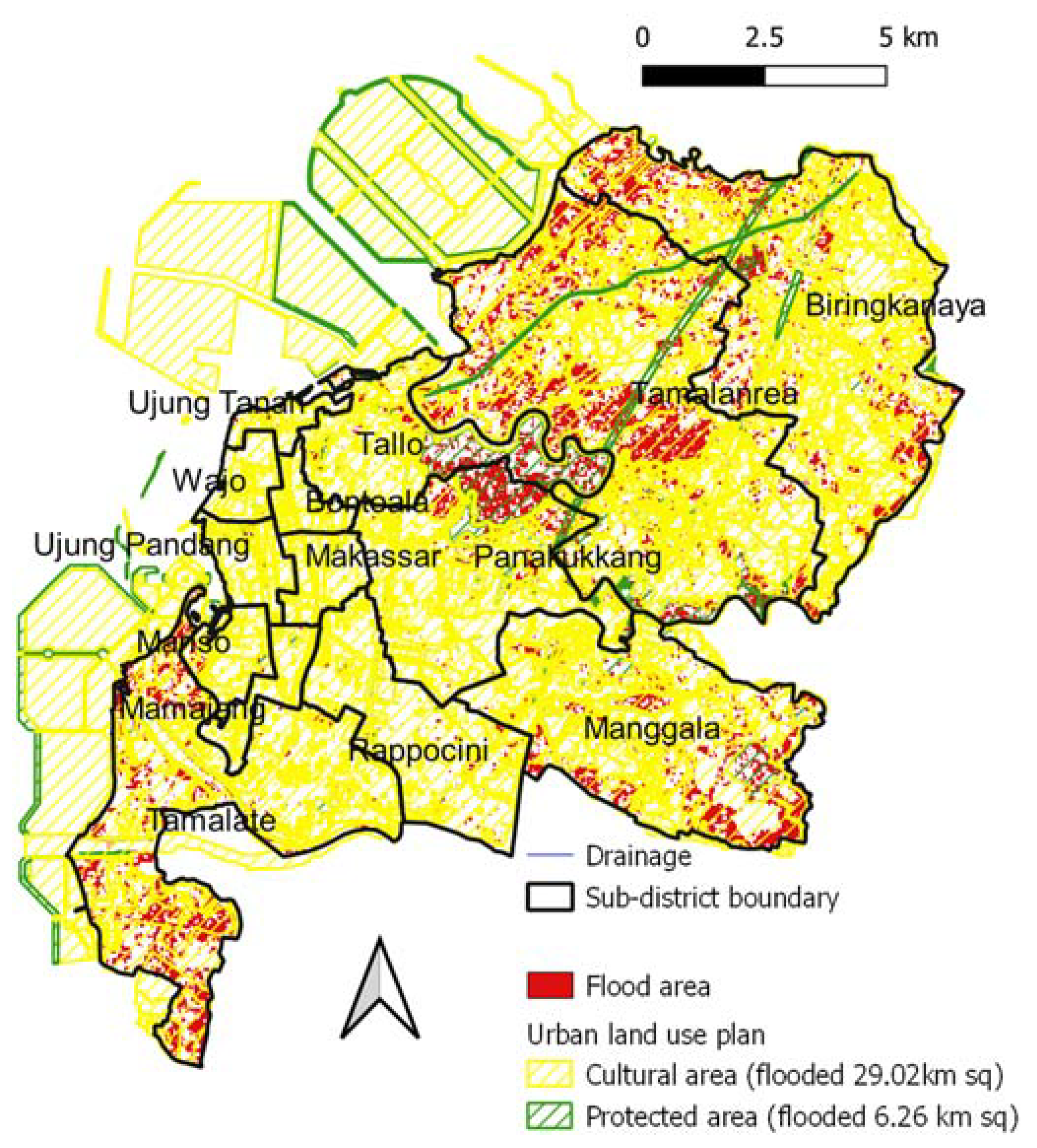
A significant facet of this development is revealed in Figure 7, illustrating Makassar City's predominantly urban land use plan, with cultural areas taking the lead. However, a notable concern arises from the limited coverage of drainage systems in several sub-districts. This issue became acutely evident during the February 2023 floods, which inundated a staggering 29.02 square kilometers or 82.26% of the cultural areas.
In light of these challenges, it is imperative that this study advocates for heightened attention to be directed towards the development of drainage systems, particularly in the Tamalanrea, Manggala, and Biringkanaya subdistricts within the cultural areas. Recognizing that the cultural zones serve as the epicenter of socio-economic development, placing a sharper focus on their resilience against floods will undoubtedly yield substantial benefits in terms of flood management and urban sustainability. Ultimately, by fortifying the cultural areas, Makassar can aspire to achieve a more resilient and prosperous future.
3.5. Policy recommendations
Makassar, a city on the rise, is fast becoming the largest industrial center in the eastern part of Indonesia. This remarkable growth has positioned Makassar as a potential economic leader in Asia. However, this rapid development has also led to intensive land use changes as a consequence of urbanization. The implications of such changes are far-reaching, particularly in terms of increased vulnerability to flood-related damage. To navigate these challenges effectively, the government must take proactive steps, primarily through meticulous urban land use planning and the establishment of a well-connected drainage network.
The city's transformation into an industrial powerhouse has attracted a surge in population and economic activities. As more people flock to Makassar in search of opportunities, urbanization has surged, exerting immense pressure on land resources. This has translated into an unprecedented transformation of the city's landscape, characterized by the proliferation of residential, commercial, and industrial areas.
With this rapid urban expansion comes a heightened risk of flooding, especially during the rainy season. Inadequate drainage infrastructure coupled with haphazard urban development exacerbates the city's susceptibility to flood-related damage. Without effective planning and a well-connected drainage network, Makassar faces not only the immediate threat of flooding but also long-term consequences such as infrastructure damage, economic losses, and public health hazards.
To safeguard the city's future and foster sustainable growth, the government must prioritize urban land use planning. This entails zoning regulations, building codes, and infrastructure development that can withstand the challenges posed by urbanization. Moreover, a well-connected drainage network is essential to manage excess water during heavy rainfall and mitigate flood risks.
Furethemore, the local government should prioritize drainage system development because it gives the crucial role of drainage systems in mitigating flood impacts, prioritize the development and maintenance of drainage systems in flood-prone areas. Focus on areas like Tamalanrea, Manggala, and Biringkanaya subdistricts, which were identified as highly vulnerable due to the absence of drainage systems. Moreover, expanding drainage coverage is required, by increase the coverage of drainage systems in urban areas, particularly in locations with high population density and significant economic activity. This includes the cultivation areas that were heavily flooded, causing economic losses. Expanding drainage coverage will help reduce the impact of floods on agriculture and businesses. Flat slope area and low elevation area recognized influencing the flood vulnerability. Hence, prioritize the development of drainage systems in these areas with slopes ranging from 0-0.3 degrees and elevations between 0-8 meters. These flatter areas are more susceptible to flooding and require special attention to enhance flood resilience.
The local government should integrate the flood risk reduction in to urban land use planning. The new urban planning should ensure that cultural areas are designed to include effective drainage systems. This will not only protect cultural sites but also contribute to overall flood resilience. Moreover, they should implement the land use policies that discourage cultivation in flood-prone areas, especially in locations with inadequate drainage. By implementing these policy recommendations, Makassar City may significantly enhance its resilience to monsoonal floods and reduce the economic, social, and environmental impacts associated with such events.
Several big cities in the world have successfully managed floods by well-connected drainage. Singapore, a small island nation with a tropical climate, experiences frequent heavy rainfall. To manage this challenge, the city-state has implemented a comprehensive drainage system known as the Marina Barrage. This dam creates a freshwater reservoir and regulates water flow into the sea, preventing both flooding and ensuring a stable water supply for the city [25], as well as Hongkong installed drainage systems for stormwater related disasters [25,26]. Another success story came from Amsterdam, a city built partly below sea level, is known for its sophisticated canal system. The city uses a combination of canals, locks, and sluices to manage water levels. Additionally, Amsterdam has developed advanced stormwater management techniques, such as green roofs and permeable pavements, to absorb rainwater and reduce the burden on its drainage infrastructure[27,28,29]. Additionally, Shanghai, a rapidly growing metropolis, has faced severe flooding in the past. To address this, the city has expanded its network of drainage canals and built large reservoirs. The Suzhou Creek, once heavily polluted, has been transformed into a clean waterway that also serves as a flood control channel, protecting the city during heavy rains[30]. The most successful experience come from Tokyo, one of the most densely populated cities globally, is prone to heavy rainfall and typhoons. The city has invested heavily in an intricate drainage system to combat floods. This system includes a network of underground tunnels, reservoirs, and canals designed to divert and manage excess rainwater. One notable example is the G-Cans Project, a massive underground reservoir that can hold up to 10,000 tons of water. This system has significantly reduced the occurrence of flooding in Tokyo[31]. These cities’ experience illustrated how well-connected drainage systems and innovative stormwater management strategies are essential for big cities to protect against floods and ensure the safety and resilience of their communities. These infrastructure investments not only prevent property damage but also contribute to sustainable water resource management.
3.6. Study limitation and future study
This study had a specific focus: assessing the physical flood susceptibility during the February flood season. To achieve this goal, a comprehensive survey was undertaken, aiming to quantify the extent of land cover and determine the flood inundation area. However, it's important to note that this analysis was solely dedicated to the physical aspects and did not take into account the socio-economic factors affecting the population residing in flood-prone regions.
Consequently, the study did not incorporate the assessment of economic losses incurred during these flooding events. Nevertheless, it is worth highlighting that this omission is deliberate, with the intention to address this critical aspect in future research endeavors. This holistic approach will offer a more comprehensive understanding of the overall impact of flooding, encompassing both the physical and economic dimensions
5. Conclusions
Makassar's ascent as an industrial giant in Asia brings immense promise, but it also carries the burden of intensified land use changes due to urbanization. To ensure a resilient future, the government must lead the way with strategic urban planning and investment in drainage infrastructure. Only then can Makassar continue to prosper while safeguarding its residents from the increasing threats of flooding and damage.
The integration of geospatial data and the validation process have substantially improved flood analysis and prediction. While there are challenges such as data source gaps and timing constraints, the accuracy achieved is a testament to the potential of combining machine learning and geospatial information for more effective flood risk assessment and management.
The study focused on assessing the flood-prone areas in Makassar during the February monsoonal flood using machine learning tools. The flood inundation area map revealed that several sub-districts, including Panakukang, Ujung Panjang, Mamajang, Mariso, and Rappocini, had drainage systems, while others did not. Tamalanrea experienced the most significant flooding because no drainage system and more cultivation land use cover, exacerbated by its low slope degree. Drainage systems played a crucial role in mitigating flood impacts, with Panakukang subdistrict showing effective drainage connectivity and less flooding even though flat area.
The study found that cultivation areas were the most heavily flooded land cover, causing economic losses due to failed harvesting. Floods in built-up areas had a severe impact on the population, given the high population density, and the impermeable surfaces prolonged inundation. In this study, Slope and elevation were identified as factors influencing inundation, with flatter areas more prone to flooding
Author Contributions
Andi Besse Rimba: conceptualization, methodology, machine learning scripting, investigating, writing—original draft; Andi Arumansawang: methodology, investigating, writing related to drainage and reviewing; I Putu Wira Utama: writing related to urban land use and reviewing; Saroj Kumar Chapagain: writing related to policy recommendation and reviewing; Made Bunga: writing related to urban land use and Reviewing; Geetha Mohan: Writing related to policy recommendation and reviewing; Kuncoro Teguh Setiawan: writing related to machine learning recommendation and Reviewing; Takahiro Osawa: writing related to machine learning and reviewing. All authors have read and agreed to the published version of the manuscript.
Data Availability Statement
We utilized the data set from Google Earth Engine, Makassar City Government and field survey.
Acknowledgments
Thank you very much to those who have provided valuable comments in their reviews, helping us enhance this study.
Conflicts of Interest
The authors declare no conflict of interest
References
- Tanoue, M.; Taguchi, R.; Alifu, H.; Hirabayashi, Y. Residual flood damage under intensive adaptation. Nat. Clim. Chang. 2021, 11, 823–826. [Google Scholar] [CrossRef]
- BNPB, ‘Banjir Melanda Kota Makassar Sebanyak 1.869 Jiwa Mengungsi (Floods Hit Makassar City, As Many As 1,869 People Displaced)’. https://bnpb.go.id/berita/banjir-melanda-kota-makasar-sebanyak-1869-jiwa-mengungsi (accessed Jul. 07, 2023).
- BPS-Statistics of Makassar Municipality, ‘Kota Makassar Dalam Angka 2023 (Makassar Municipality in Figure 2023)’, BPS-Statistics of Makassar Municipality, Makassar City, 1102001.7371, Feb. 2023. Accessed: Jul. 07, 2023. [Online]. Available: https://makassarkota.bps.go.id/publication/2023/02/28/b51bbd208d15ce2626a75efb/kota-makassar-dalam-angka-2023.html.
- Widodo, T.N.; Zubair, H.; Padjung, R. Land use change study and the increased risk of floods disaster in Jeneberang watershed at Gowa Regency, South Sulawesi, Indonesia. IOP Conf. Ser. Earth Environ. Sci. 2021, 824, 012045. [Google Scholar] [CrossRef]
- Musliadi; Chaerul, M. ; Gusty, S. Study on Flood Simulation of Tallo Watershed, Makassar City, South Sulawesi Province. J. Phys. Conf. Ser. 2021, 1899, 012063. [Google Scholar] [CrossRef]
- Thoban, M.I.; Hizbaron, D.R. Urban resilience to floods in parts of Makassar, Indonesia. E3S Web Conf. 2020, 200, 01007. [Google Scholar] [CrossRef]
- Google Earth Engine, ‘Google Earth Engine’. [Online]. Available: https://earthengine.google.com/.
- Nghia, B.P.Q.; Pal, I.; Chollacoop, N.; Mukhopadhyay, A. Applying Google earth engine for flood mapping and monitoring in the downstream provinces of Mekong river. Prog. Disaster Sci. 2022, 14, 100235. [Google Scholar] [CrossRef]
- Mehmood, H.; Conway, C.; Perera, D. Mapping of Flood Areas Using Landsat with Google Earth Engine Cloud Platform. Atmosphere 2021, 12, 866. [Google Scholar] [CrossRef]
- Tarpanelli, A.; Mondini, A.C.; Camici, S. Effectiveness of Sentinel-1 and Sentinel-2 for flood detection assessment in Europe. Hydrological Hazards 2022, preprint. [Google Scholar] [CrossRef]
- Rimba, A.B.; Miura, F. Evaluating the Extraction Approaches of Flood Extended Area by Using ALOS-2/PALSAR-2 Images as a Rapid Response to Flood Disaster. J. Geosci. Environ. Prot. 2017, 05, 40–61. [Google Scholar] [CrossRef]
- Foroughnia, F.; Alfieri, S.M.; Menenti, M.; Lindenbergh, R. Evaluation of SAR and Optical Data for Flood Delineation Using Supervised and Unsupervised Classification. Remote. Sens. 2022, 14, 3718. [Google Scholar] [CrossRef]
- Brisco, B.; Shelat, Y.; Murnaghan, K.; Montgomery, J.; Fuss, C.; Olthof, I.; Hopkinson, C.; Deschamps, A.; Poncos, V. Evaluation of C-Band SAR for Identification of Flooded Vegetation in Emergency Response Products. Can. J. Remote. Sens. 2019, 45, 73–87. [Google Scholar] [CrossRef]
- Tsyganskaya, V.; Martinis, S.; Marzahn, P. Flood Monitoring in Vegetated Areas Using Multitemporal Sentinel-1 Data: Impact of Time Series Features. Water 2019, 11, 1938. [Google Scholar] [CrossRef]
- Pulvirenti, L.; Pierdicca, N.; Chini, M.; Guerriero, L. An algorithm for operational flood mapping from Synthetic Aperture Radar (SAR) data using fuzzy logic. Nat. Hazards Earth Syst. Sci. 2011, 11, 529–540. [Google Scholar] [CrossRef]
- García-Pintado, J.; Neal, J.C.; Mason, D.C.; Dance, S.L.; Bates, P.D.; García-Pintado, J.; Neal, J.C.; Mason, D.C.; Dance, S.L.; Bates, P.D. Scheduling satellite-based SAR acquisition for sequential assimilation of water level observations into flood modelling. J. Hydrol. 2013, 495, 252–266. [Google Scholar] [CrossRef]
- Kim, J.; Kim, H.; Kim, D.-J.; Song, J.; Li, C. Deep Learning-Based Flood Area Extraction for Fully Automated and Persistent Flood Monitoring Using Cloud Computing. Remote. Sens. 2022, 14, 6373. [Google Scholar] [CrossRef]
- Manjusree, P.; Kumar, L.; Bhatt, C.M.; Rao, G.S.; Bhanumurthy, V. Optimization of threshold ranges for rapid flood inundation mapping by evaluating backscatter profiles of high incidence angle SAR images. Int. J. Disaster Risk Sci. 2012, 3, 113–122. [Google Scholar] [CrossRef]
- Hansen, M.C.; Potapov, P.V.; Moore, R.; Hancher, M.; Turubanova, S.A.; Tyukavina, A.; Thau, D.; Stehman, S.V.; Goetz, S.J.; Loveland, T.R.; et al. High-resolution global maps of 21st-century forest cover change. Science 2013, 342, 850–853. [Google Scholar] [CrossRef] [PubMed]
- Rahman, M.; Ningsheng, C.; Mahmud, G.I.; Islam, M.; Pourghasemi, H.R.; Ahmad, H.; Habumugisha, J.M.; Washakh, R.M.A.; Alam, M.; Liu, E.; et al. Flooding and its relationship with land cover change, population growth, and road density. Geosci. Front. 2021, 12, 101224. [Google Scholar] [CrossRef]
- BPPD Kota Makassar, ‘RTRW Kota Makassar (Urban Land Use Plan of Makassar City) 2015-2034’, Makassar City, 2015.
- Long, S.; E Fatoyinbo, T.; Policelli, F. Flood extent mapping for Namibia using change detection and thresholding with SAR. Environ. Res. Lett. Env. Res Lett 2014, 9, 35002–35009. [Google Scholar] [CrossRef]
- Voormansik, K.; Praks, J.; Antropov, O.; Jagomagi, J.; Zalite, K. Flood Mapping With TerraSAR-X in Forested Regions in Estonia. IEEE J. Sel. Top. Appl. Earth Obs. Remote. Sens. 2014, 7, 562–577. [Google Scholar] [CrossRef]
- Lillesand, T.; Kiefer, R.W.; Chipman, J. Remote Sensing and Image Interpretation, 5th ed.; John Wiley & Sons: Hobokan, NJ, USA, 2004; ISBN 0471152277. [Google Scholar]
- Chan, F.; Chuah, C.J.; Ziegler, A.; Dąbrowski, M.; Varis, O. Towards resilient flood risk management for Asian coastal cities: Lessons learned from Hong Kong and Singapore. J. Clean. Prod. 2018, 187, 576–589. [Google Scholar] [CrossRef]
- Chui, S.; Leung, J.K.; Chu, C. The development of a comprehensive flood prevention strategy for Hong Kong. Int. J. River Basin Manag. 2006, 4, 5–15. [Google Scholar] [CrossRef]
- Dierickx, W. Manual of surface drainage engineering. Vol. II, stream flow engineering and flood protection. Agric. Water Manag. 1985, 10, 184–185. [Google Scholar] [CrossRef]
- van der Nat, A.; Vellinga, P.; Leemans, R.; van Slobbe, E. Ranking coastal flood protection designs from engineered to nature-based. Ecol. Eng. 2016, 87, 80–90. [Google Scholar] [CrossRef]
- Nillesen, A.L. A new nature-based approach for floodproofing the Metropolitan Region Amsterdam. In Coastal Flood Risk Reduction; Elsevier, 2022; pp. 209–225. [Google Scholar] [CrossRef]
- Sun, X.; Li, R.; Shan, X.; Xu, H.; Wang, J. Assessment of climate change impacts and urban flood management schemes in central Shanghai. Int. J. Disaster Risk Reduct. 2021, 65, 102563. [Google Scholar] [CrossRef]
- Nakamura, H.; Oosawa, M. Effects of the underground discharge channel/reservoir for small urban rivers in the Tokyo area. IOP Conf. Ser. Earth Environ. Sci. 2021, 703, 012029. [Google Scholar] [CrossRef]
Figure 1.
Study area.
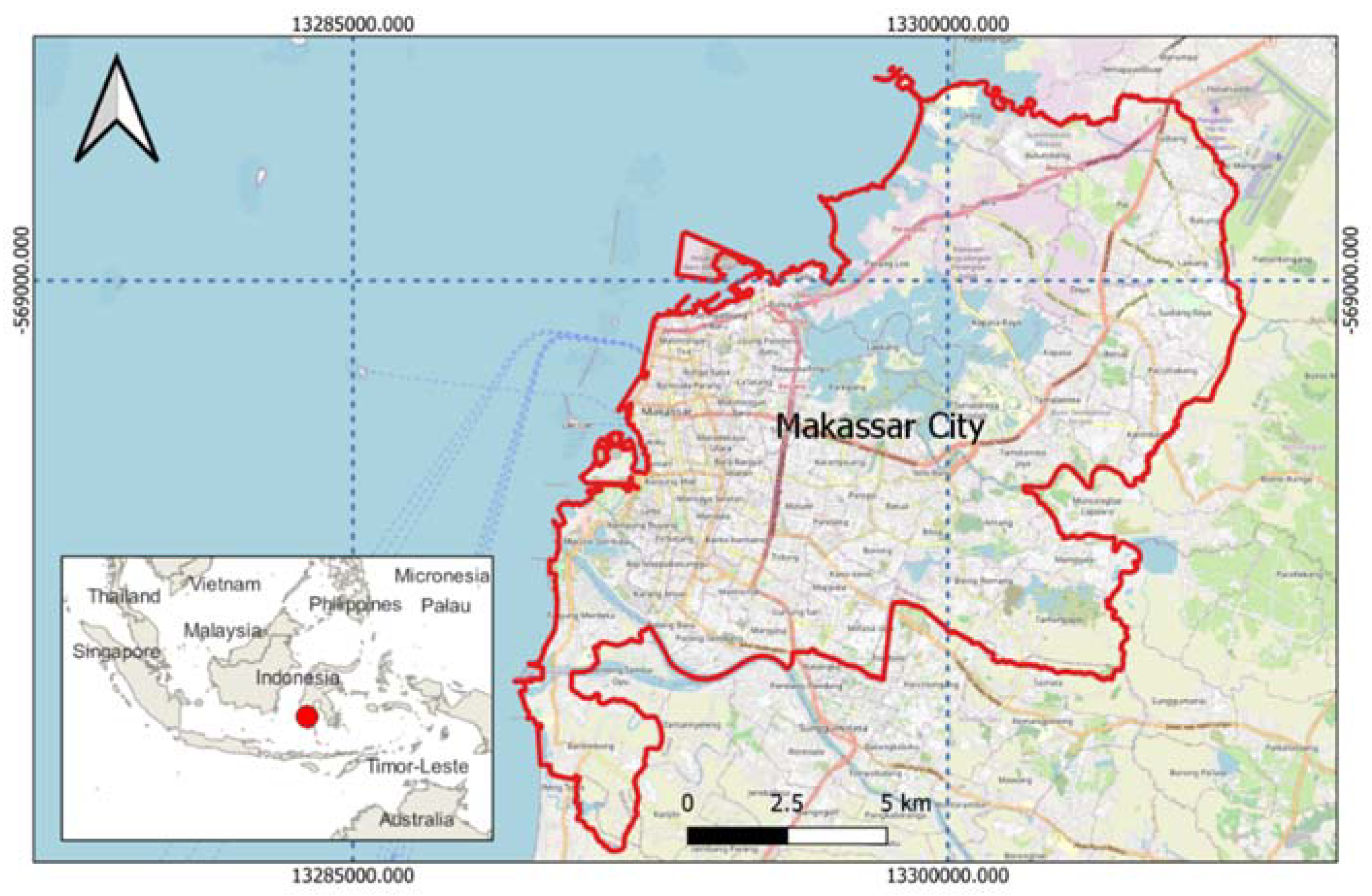
Figure 2.
Flood inundation area overlay with a). Drainage b). Land use land cover (LULC) c). Slope d). Elevation.
Figure 2.
Flood inundation area overlay with a). Drainage b). Land use land cover (LULC) c). Slope d). Elevation.
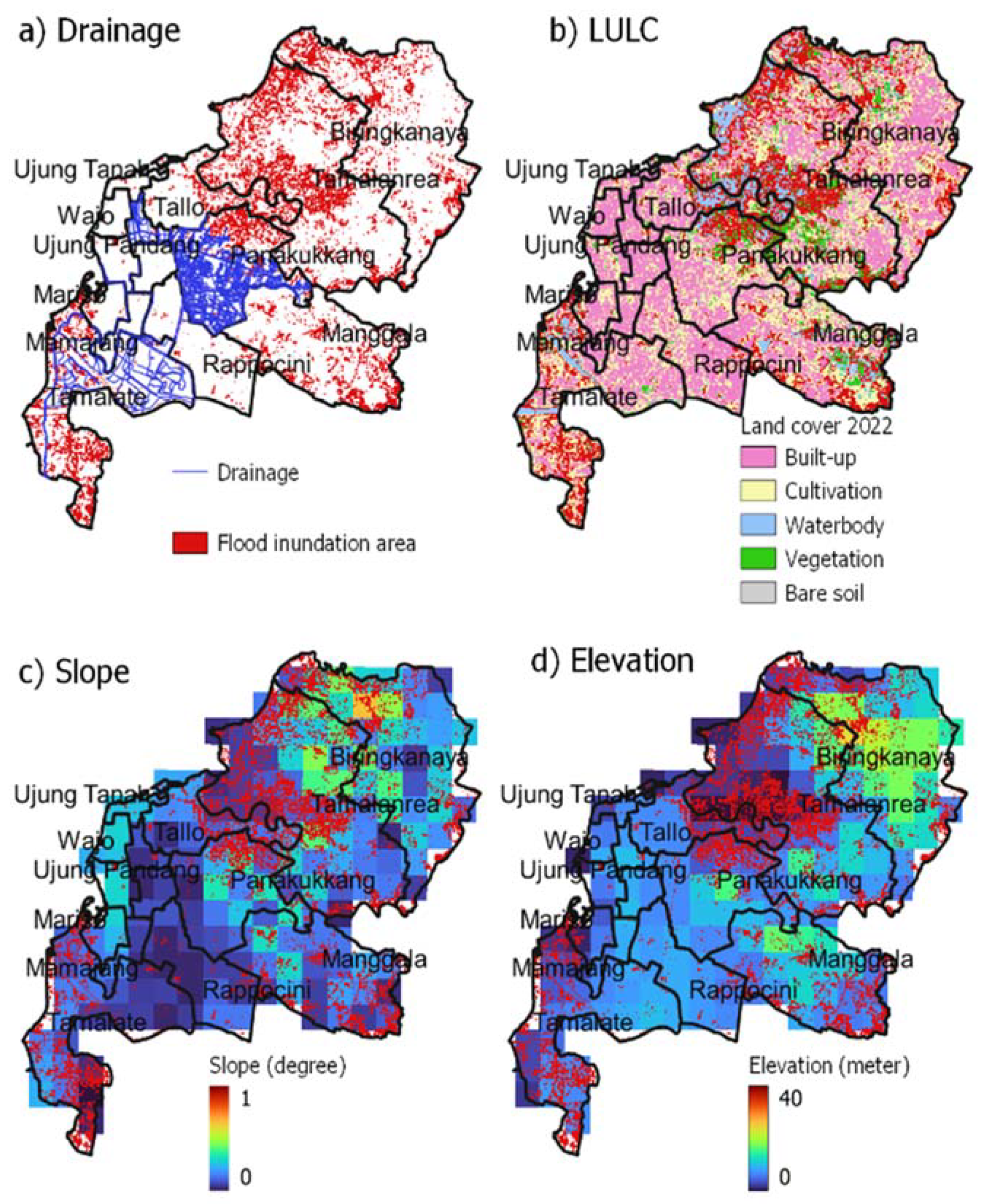
Figure 3.
Flood inundation area (check) and drainage length per sub-district.

Figure 4.
Total area of flooded land cover.
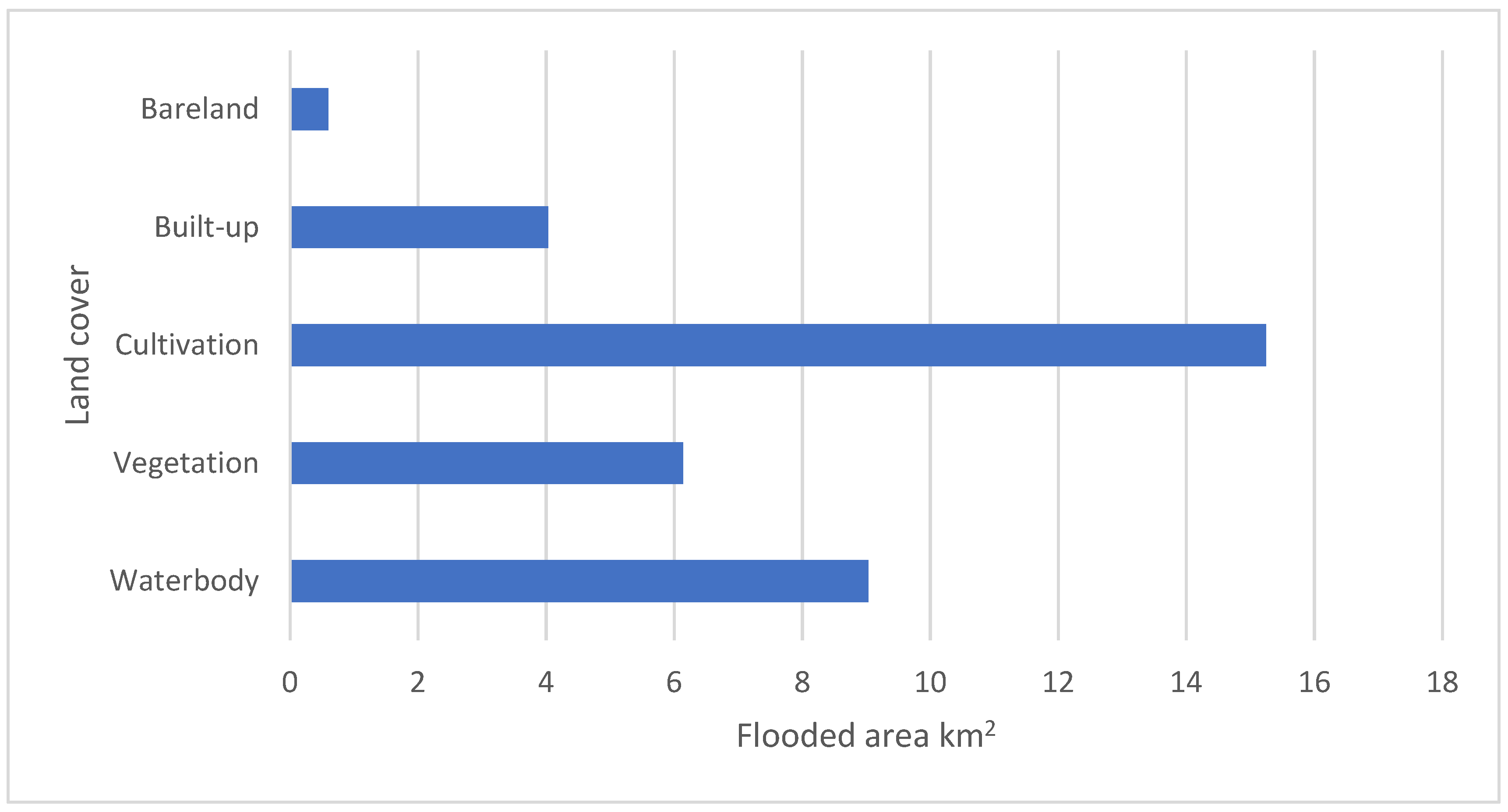
Figure 5.
Flooded area based on slope.
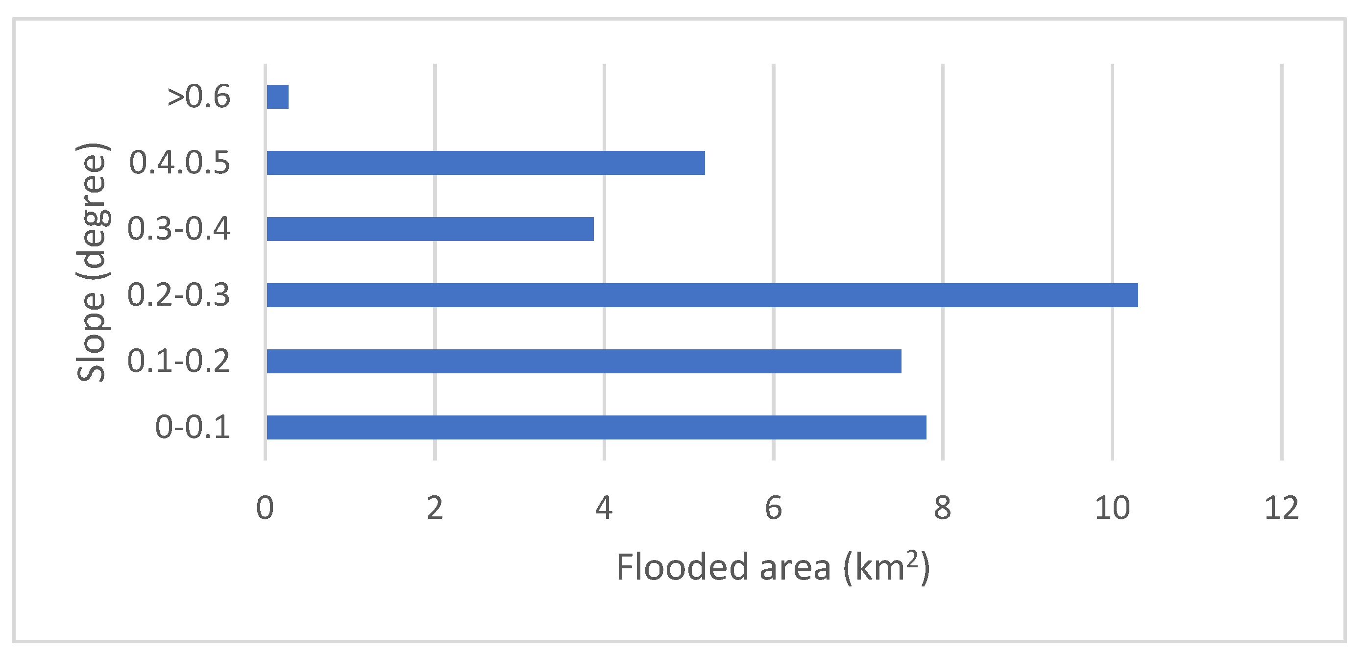
Figure 6.
Flooded area and elevation.
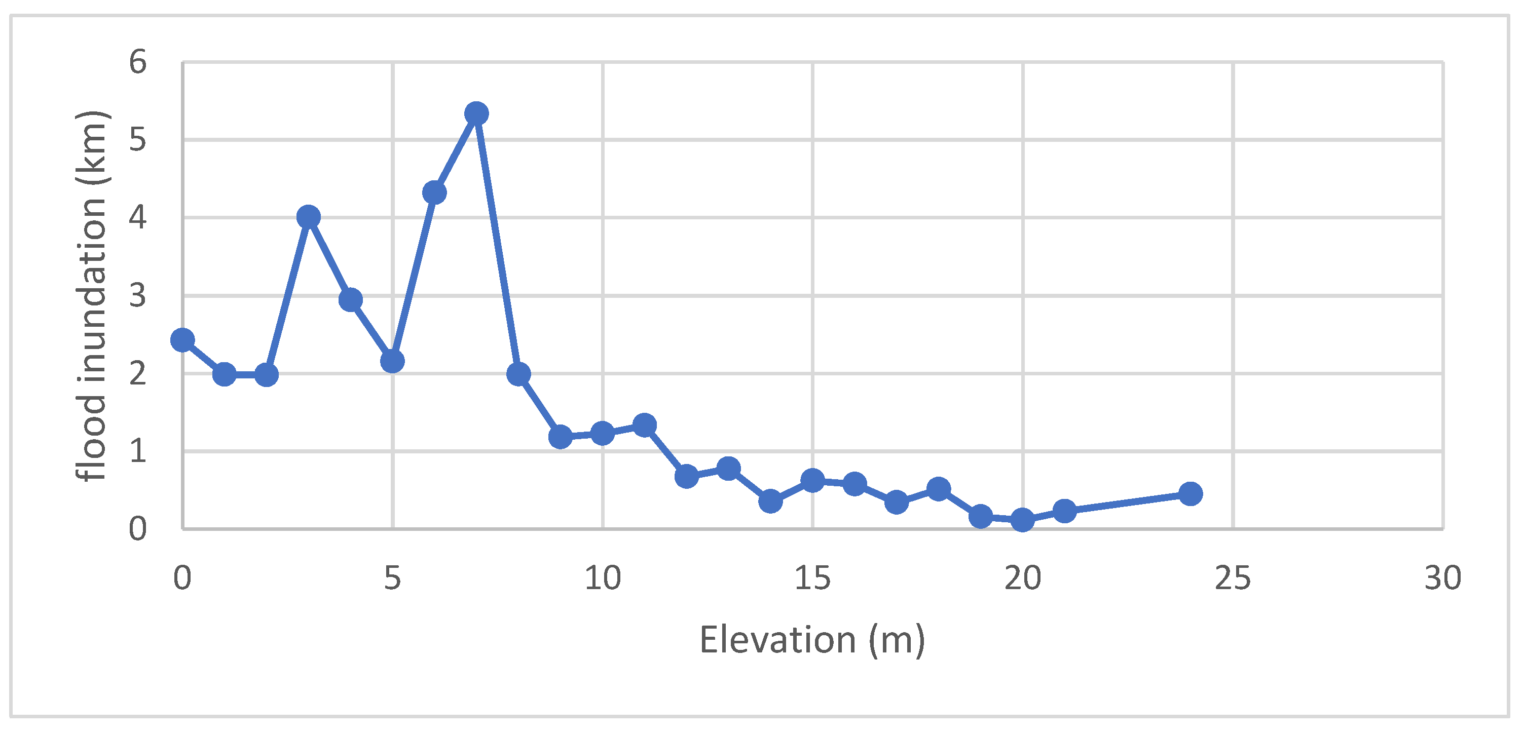
Figure 7.
Flooded area and urban land use plan.
Disclaimer/Publisher’s Note: The statements, opinions and data contained in all publications are solely those of the individual author(s) and contributor(s) and not of MDPI and/or the editor(s). MDPI and/or the editor(s) disclaim responsibility for any injury to people or property resulting from any ideas, methods, instructions or products referred to in the content. |
© 2023 by the authors. Licensee MDPI, Basel, Switzerland. This article is an open access article distributed under the terms and conditions of the Creative Commons Attribution (CC BY) license (http://creativecommons.org/licenses/by/4.0/).
Copyright: This open access article is published under a Creative Commons CC BY 4.0 license, which permit the free download, distribution, and reuse, provided that the author and preprint are cited in any reuse.


