Submitted:
18 September 2023
Posted:
19 September 2023
You are already at the latest version
Abstract
Objective: The study aimed to provide a picture total of the forest and erosion status of the beach and dykes of Kien Giang and Ca Mau. Theoretical framework: Kien Giang and Ca Mau are located in the West Sea, and in recent years, along the coast of this region, erosion of the coast and sea dykes has been profound. Method: There are 18 sample plots for testing. The map also includes 68 survey plots that are predefined and used as a basis for positioning in the field. The measurement indicators include tree species identification. Results and conclusion: The level of erosion in Ha Tien’s forests varies based on tree density and environmental factors. The forest with no erosion has a thickness of 9,600 trees/ha and a stem diameter of 19 cm, while the extremely erosion forest has 2,000 trees/ha and a stem diameter of 6 cm. Topographically, Ha Tien has little erosion, while U Minh is a low-lying area with high erosion. Erosion levels are 1-2 in January-April, 4-5 in May-October, and 3 in November-December. Currently, the section is divided into 28 sub-sections, with Kien Giang having 23. One sub-section is level 1, 11 sub-sections are level 2, 1 is level 3, 3 are level 4, and 3 are level 5. In Ca Mau, two sub-sections are level 4, and 3 are level 5. Implications of the research: With climate change and rising sea levels, erosion levels tend to increase one level in sub-section areas in the coming years.
Keywords:
climate change
; coast and sea dykes
; mangroves
; sea level rise
; West Sea
; Kien Giang province
1. Introduction
Vietnam boasts one of the world’s most extensive mangrove forests, particularly in the coastal regions of the South and the Mekong Delta (Tran 2007). These forests hold significant ecological and biological diversity values and offer substantial economic benefits (Kathiresan & Bingham 2001; Das et al 2015). Mangroves play a crucial role in preventing coastal erosion and degradation (Besset et al 2019). Their unique characteristics, e.g., their submerged root system that affects water flow and their ability to withstand saline environments, make them essential for coastal protection. The extensive root system of mangrove trees creates a network that helps to stabilize the soil and prevent erosion caused by high tides and waves (Alongi 2008). Moreover, mangroves can be used to restore eroding coastlines by creating a forest area that stabilizes the soil and provides an area for planting (El-Nahry & Doluschitz 2010; Besset et al 2019). However, the mangrove forests in Vietnam are under threat from various challenges. Economic development and urbanization have led to a reduction in the mangrove forest area, impacting the existence of species and ecosystems. Environmental pollution and ecological imbalances have also diminished the quality and quantity of species in the mangrove forests (Lovelock et al 2015).
A sea dike is an engineering structure built along the coast to prevent waves and protect the land from erosion and flooding. Sea dikes play a critical role in protecting the mainland, infrastructure, and people living in coastal areas (Schoonees et al 2019). One of the essential functions of a sea dike is to protect the coast from erosion and abrasion. Strong waves and currents can erode the coastline, causing damage to properties and infrastructure built on the coast. A sea dike is a structure that can resist the force of waves and currents, helping to minimize their impact on the coast and the mainland (Le et al 2022). The relationship between sea dikes and mangrove forests is complex and interactive (Alongi 2014; Barbier 2016). In many cases, sea dikes are built to protect the mainland from erosion and abrasion, which can negatively impact mangrove forests. This can happen when a sea dike interrupts the flow of water and nutrients from the river into the mangrove forest. The mangrove forest’s trees may not receive the necessary nutrients and water to grow and may die (Balke et al 2011). However, if designed and constructed properly, a coastal dike can support the development of mangrove forests. Coastal dikes can help create ideal ecological conditions for mangrove forests by maintaining the necessary amount of water for forest development and protecting the forest from the negative impacts of waves and storms (Whitehead et al 1997). In addition, mangrove forests can also help protect coastal dikes from erosion and shoreline retreat. Mangrove forests can retain sand, soil, and nutrients, reducing coastal erosion. At the same time, mangrove forests provide a habitat for plant and animal species, helping to create biodiversity and protect the coastal environment (Sarker et al 2021).
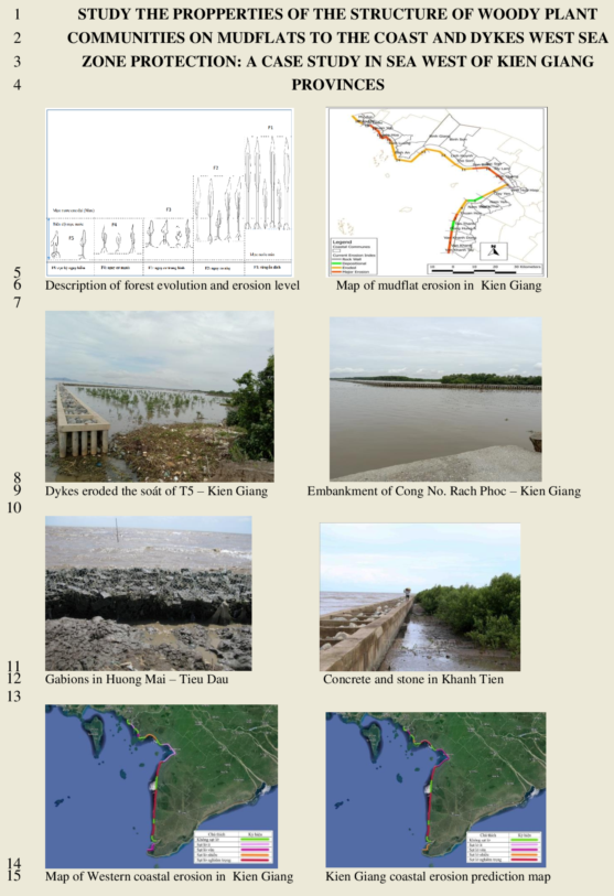
The two provinces of Kien Giang and Ca Mau are located in the West Sea. In recent years, along the coast of this region, erosion of the coast and sea dykes has been profound, with a total length of ~300 km, ranging from Rach Cheo, Phu Tan district (Ca Mau) to Mui Nai, Ha Tien City (Kien Giang). On August 4th, 2020, the West sea dyke was damaged by storm No.2, causing a landslide of one section, 700 meters long, in the Tieu Dua area, Van Khanh Tay commune, An Minh district province. These sections have little or no forest, from Mui Nai to Tieu Dua, it is 200 kilometer then, 90 kilometers is lost (Kien Giang Protection Forest Management Board 2020); the West sea dykes due to storm No. 2 eroded four sections with a length of 500 meter in Khanh Tien, U Minh (Ca Mau) with 254 kilometer is 67 kilometer eroded, the erosion speed is 20 – 25 kilometers/year (West Ca Mau Marine Protected Forest Management Board 2020). This research found the scientific basis of forest properties, that total parameters into erosion levels in a month per year made of erosion from minor to extreme impacts to mangrove forest, the coast, and sea dykes in Kien Giang and Ca Mau provinces. The study result will be a picture total of the forest and erosion status of the beach and dykes of Kien Giang and Ca Mau. This research finds out measures to protect the coast and dykes, including forest development, are necessary for the condition of climate change and sea level rise at present.
2. Material and Methods
There are 18 sample plots for testing, including Ha Tien, Kien Luong, Hon Dat, An Bien, An Minh (Kien Giang), and U Minh (Ca Mau), each consisting of three plots. The map also includes 68 survey plots that are predefined and used as a basis for positioning in the field. Additionally, there are 96 measuring plots, with each zone having three plots and a measuring plot area of 100 m². The measurement indicators include tree species identification, diameter at 1.3m above the ground (D1.3), the height of the tree canopy (Hvn), average canopy diameter measured in the east-west and south-north directions, and a quality rating of the trees on a 5-point scale ranging from 1 (dead tree) to 2 (lost canopy), 3 (normal growth), 4 (good tree) and 5 (strong growth). The forest is classified into five levels based on erosion risk, ranging from F1 (no erosion) to F2 (small erosion), F2 (medium erosion), F4 (dangerous erosion), and F5 (very dangerous erosion).
The forest’s classification is based on several factors, including the current status of the mangrove forest, density calculations, canopy height, tree trunk size, and ground cover. The difference between the tallest and shortest tree height is denoted by (fh), while the difference between the largest and smallest trunk size at 1.3m is denoted by (fd). The largest and smallest canopy diameter difference is represented by (fc), and the difference between the highest and lowest tree density per hectare is denoted by (fn). Finally, the difference between the largest and smallest forest canopy area per hectare is characterized by (fs). The overall indicator is calculated as F = (fh + fd + fc + fn + fs) / n, where n is 5 in this case. These indicators help assess the forest’s condition and level of erosion risk.
3. Results and Discussion
Characteristics of Mangrove Forests
The Ha Tien section, located in My Duc, Ha Tien city, has a plot size of 100 square meters with a tree density ranging from 63 to 99 trees. In addition, there is a protection forest band extending from 50 to 100 meters, and the height of the forest ranges from 3.67 to 8.77 meters. The diameter of the trees (measured at 1.3 meters above the ground) ranges from 4.17 to 13.26 centimeters. The canopy diameter of the trees ranges from 1.35 to 4.62 meters, and the tree canopy cross-sectional area ranges from 1.43 to 16.76 square meters. The surface area covered by the tree canopy in the plot ranges from 67 to 240 square meters, as shown in Table 1. This information provides insight into the composition and characteristics of the forest in the Ha Tien section. The tree density, canopy size, and cross-sectional area can help estimate the forest’s overall biomass and carbon storage potential. The diameter and height measurements can also be used to estimate the age and health of the trees, which are essential factors in forest management and conservation. Overall, this data is helpful in understanding the ecological and environmental value of the Ha Tien section and can inform decisions regarding its management and protection.
The Kien Luong section, spanning from Ta Sang, Duong Hoa to Rach Dung, Binh Tri, has a variable tree density ranging from 16 to 105 trees per plot. The height of the trees in this section ranges from 3.67 to 8.77 meters, and the diameter of the tree trunks measured 1.3 meters from the ground varies from 4.17 to 13.26 centimeters across different locations. The canopy diameter of the trees ranges from 1.35 to 4.62 meters, and the cross-sectional area of the tree canopy in the plot ranges from 1.43 to 16.76 square meters. The plot’s canopy area covered by the trees ranges from 67 to 241 square meters, as shown in Table 2. This data provides valuable information about the forest in the Kien Luong section, including its density, size, and ecological value. The varying tree density and diameter measurements can help estimate the trees’ age and health and provide insights into the forest’s biodiversity. The tree canopy size and cross-sectional area can also be used to estimate the forest’s overall biomass and carbon storage potential, which is essential for sustainable forest management and conservation efforts.
The area of Hon Dat, spanning from Binh Giang to My Lam, has a tree density ranging from 11 to 93 trees per 100 square meters in the plot. The protection forest band ranges from 0 to 35 meters, and the forest height varies from 5.54 to 9.04 meters. The diameter of the tree trunks measured at 1.3 meters above the ground ranges from 5.76 to 17.90 centimeters. The canopy diameter of the trees varies from 1.63 to 5.56 meters, and the cross-sectional area of the tree canopy ranges from 2.09 to 24.28 square meters. The total canopy cross-sectional area of the trees in the plots ranges from 147 to 557 square meters, as shown in Table 3 and Table 4.
This information provides valuable insights into the composition and characteristics of the forest in Hon Dat. The tree density, height, and diameter measurements can help estimate the forest’s overall biomass and carbon storage potential. The tree canopy size and cross-sectional area can also be used to estimate the forest’s contribution to the local hydrological cycle, such as through interception and evapotranspiration. Moreover, the protection forest band is essential to forest management in protecting against soil erosion, landslides, and other natural hazards. The information provided in the tables can be used to evaluate the ecological value of the forest and guide management practices for sustainable forest use and conservation.
The An Bien section, spanning from 3 Bien in Nam Yen commune to Xeo Quao in Nam Thai commune, has a tree density in plots ranging from 12 to 46 trees per 100 square meters. The protection forest band in this section ranges from 30 to 200 meters, and the forest height varies from 4.73 to 13.50 meters. The diameter of the trees measured at 1.3 meters above the ground ranges from 4.93 to 21.09 centimeters. The canopy diameter of the trees varies from 1.45 to 4.45 meters, and the cross-sectional area of the tree canopy ranges from 1.65 to 15.55 square meters. The total cross-sectional area of the tree canopy in the plots ranges from 45 to 363 square meters, as shown in Table 5 and Table 6. This information provides valuable insights into the composition and characteristics of the forest in the An Bien section. The tree density, height, and diameter measurements can help estimate the forest’s overall biomass and carbon storage potential. The tree canopy size and cross-sectional area can also be used to estimate the forest’s contribution to the local hydrological cycle, such as through interception and evapotranspiration. Moreover, the protection forest band is essential to forest management in protecting against soil erosion, landslides, and other natural hazards. The information provided in the tables can be used to evaluate the ecological value of the forest and guide management practices for sustainable forest use and conservation.
The An Minh section, extending from Kien Giang to U Minh in Ca Mau, has a tree density in plots ranging from 11 to 41 trees per 100 square meters. The protection forest band in this section ranges from 0 to 20 meters, and the forest height varies from 4.06 to 7.64 meters. The diameter of the trees measured at 1.3 meters above the ground ranges from 5.73 to 14.91 centimeters. The canopy diameter of the trees varies from 1.65 to 4.49 meters, and the cross-sectional area of the tree canopy ranges from 2.14 to 15.83 square meters. The total cross-sectional area of the tree canopy in the plots ranges from 66 to 222 square meters, as shown in Table 7 and Table 8.
This information can be helpful in understanding the composition and characteristics of the forest in the An Minh section. The tree density and diameter measurements can provide insights into the forest’s overall biomass and carbon storage potential. The tree canopy size and cross-sectional area can also be used to estimate the forest’s contribution to local hydrological cycles, such as through interception and evapotranspiration. The protection forest band is an essential component of forest management in protecting against soil erosion, landslides, and other natural hazards. The data provided in the tables can be used to evaluate the ecological value of the forest and guide management practices for sustainable forest use and conservation.
The forest level is classified based on several factors, including the status of the mangrove forest, density calculation, canopy height, tree trunk size, and ground cover. The classification ranges from F1, a forest without erosion, to F5, a forest with very dangerous erosion. The formula used to calculate the classification is (Hmax - Hmin + D1,3max - D1.3min + Dcmax - Dcmin + N/ha.max - N/ha.min + Sc/ha. max - Sc/ha. min)/5, where H is the height of the tallest and lowest species, D1.3m is the trunk size at 1.3m of the tallest and lowest species, Dc is the canopy diameter of the tallest and lowest species, N/ha is the tree density per hectare of the tallest and lowest species, and Sc/ha is the forest canopy area of the tallest and lowest species. The forest level classification for the West Sea region is presented in Table 9, Table 10 and Table 11, which shows the level of erosion risk for each forest level.
Accoringly, F1: N(96) + H(13) + D1.3(19) + Dc(5) + Gc(22) + Gc/plot(506) + Rd(272), F2: N(76) + H(11) + D1,3(16) + Dt(4) + Gt(17) + Gc/plot(403) + Rd(215), F3: N(58) + H(9) + D1.3(13) + Dc(3) + Gc(13) + Gc/plot(301) + Rd(157), F4: N(39) + H(7) + D1,3(9) + Dc(2.5) + Gc(8) + Gc/plot(199) + Rd(100), F5: N(20)+H(5) + D1.3(6) + Dc(1,8) + Gc(3.5) + Gc/plot(96) + Rd(43) with F1 = 1+1+1+1+1+1+1/7 = 1 , F2 = 0.80 + 0.84 + 0.83 + 0,.3 + 0.79 + 0.80 + 0.79 = 0.79, F3 = 0.61 + 0.69 + 0.65 + 0.67 + 0.59 + 0.59 + 0.58 = 0.63, F4 = 0.41 + 0.53 + 0.48 + 0.44 + 0.37 + 0.39 + 0.37 = 0.42, and F5 = 0.21 + 0.37 + 0.30 + 0.25 + 0.17 + 0.19 + 0.16 = 0.24
F1 is a sustainable forest class with no erosion. It has a high density of 96 trees per 100 square meters or 9600 trees per hectare, indicating a rich forest cover. The height of the trees is 13 meters, and the diameter at 1.3 meters is 19 centimeters, suggesting that the trees are healthy and mature. The canopy size of each tree is 22 square meters, and the total canopy coverage of the forest is 506 square meters, which indicates that the forest is dense and provides ample shade. The forest band is 272 meters, meaning that the forest has a wide buffer zone and is well protected from external factors that could cause erosion. Overall, the F1 forest is sustainable with no erosion, and its characteristics demonstrate its ecological richness and health. The density of the forest was 96 trees/100 m2 (9600 trees/ha), the height of the tree was 13 m, the diameter of the tree at 1.3 was 19 cm, the canopy of the tree was 22 m2, the canopy of tree was 506 m2, the forest band was 272 m is the no erosion.
F2 is a forest class with low to moderate erosion risk. It has a density of 77 trees per 100 square meters (7700 trees per hectare) with a total canopy coverage of 403 square meters. The forest band is 15 meters. Although there is some level of erosion present, it is considered small.
F3 belongs to the medium erosion forest category. The forest density is 58 trees per 100 square meters (5800 trees per hectare), with a height of 9 meters and a diameter of 13 centimeters at 1.3 meters. The canopy of each tree is 13 square meters, and the total canopy coverage in the plot is 301 square meters. The forest band is 157 meters, indicating a moderate level of erosion.
F4 is a forest with a high level of erosion. It has a density of 39 trees per 100 square meters (3900 trees per hectare) with a height of 7 meters and a diameter of 1.3 meters of 9 centimeters. The canopy diameter is 2.5 meters with a cross-sectional area of 8 square meters and a total canopy coverage of 199 square meters. The forest band is 100 meters, which is classified as dangerous erosion.
F5 is a forest with a high risk of erosion, with a low density of 20 trees per 100 square meters (2000 trees per hectare). The height of the trees is 5 meters, and the trunk’s diameter at 1.3 meters is 6 centimeters. The canopy size of each tree is 1.8 square meters, with a total canopy coverage of 3.5 square meters. The total canopy coverage per plot is 96 square meters, and the forest band is 43 meters.
Kien Giang is a province with a coastline of 205 km that has experienced significant erosion of its mangrove forests. According to mangrove statistics from 1999 to 2006, the area of mangrove forests has increased from 3,936 ha to 5,430 ha (GIZ 2008). Most mangrove forest is found in the An Bien and An Minh districts, with a width ranging from 20 to 500 meters. However, satellite image analysis in 2012 showed that the remaining mangrove forest in Kien Giang province is only 3,500 hectares with a narrow forest band of 10 meters (GIZ 2012). Despite the small size, the mangrove forest is home to 27 plant species, with Avicennia being the most dominant species (50%), followed by Sonneratia (19%) and Rhizophora (9%) (Duke et al 2010). Unfortunately, the mangrove forests of Kien Giang province are facing severe erosion, with a total of 69.8 km eroded between 2009 and 2020. Out of this, 35 km is classified as dangerous erosion, with the most affected areas being An Bien (5 km), Kien Luong (3 km), Hon Dat (7 km), and An Minh (20 km). On average, the province experiences 20 km of erosion per year, with An Minh district experiencing 20-50 km of erosion over the last ten years, resulting in the loss of 300 ha of forest. Moving from the Tieu Dua canal in Kien Giang to Huong gate in U Minh, Ca Mau, the danger of erosion is 20m/year. From Huong Mai gate to Khanh Hoi, the threat of erosion increases to 50m/year, while from Khanh Hoi to Khanh Binh Tay Bac, the threat reduces to 20m/year. From Khanh Binh Tay Bac gate to Song Doc, the danger increases to 50m/year; from Song Doc to the end of the west coast, the threat of erosion is very great. The province’s east coast is experiencing extreme erosion of up to 50 m/year, while the Viet Khai commune section is losing land area at an average rate of 4.73 km2/year.
Kien Giang province has experienced significant erosion along its coastline, with a total length of 64.37 km affected. According to the Kien Giang Department of Agriculture and Rural Development (2020), 31.21 km of the coastline has already eroded, with 21.91 km classified as dangerous. Specifically, the areas of Kim Qui, An Bien, An Minh, Hon Dat, and Tieu Dua-Chu Vang (An Minh) have experienced hazardous erosion. The section of the coastline at Binh Giang (Hon Dat) is particularly affected, with a length of 4 km classified as dangerous. With a distance of 154 km, Ca Mau has over 80% of its size eroded. Through monitoring (GIZ Kien Giang 2012; Kien Giang Protection Forest Management Board 2020), the average landslide speed is 20 – 25 m / year, up to 50 m /year in some locations. The west coast of Ca Mau eroded wass 57 km, with many sections, not forest; the forest band is thinning. Currently, eroded is more dangerous, the protection disappears, and the dyke of the sea is threatened by big waves and high winds. The risk of broken dyke, especially in the rainy season, the southwest wind, and the high tide.
4. Conclusions
This study presented information on five distinct forest types characterized by varying levels of erosion indicated by tree density, height, trunk diameter, canopy area, and forest bandwidth. The West Sea of Kien Giang and Ca Mau was also examined, revealing erosion levels that range from negligible to very hazardous. Environmental factors influence erosion rates, which fluctuate between 1 and 5 throughout the year. The report outlines the current erosion status, dividing the area into 28 sub-sections with varying degrees of erosion ranging from minor to severe erosion (level 5). The study provides comprehensive information about the diverse forests and erosion levels in the Kien Giang and Ca Mau areas. Furthermore, it emphasizes the environmental factors that impact erosion rates and presents the current state of erosion in the region.
References
- Alongi, D.M. Mangrove forests: Resilience, protection from tsunamis, and responses to global climate change. Estuarine, Coastal and Shelf Science 2008, 76, 1–13. [Google Scholar] [CrossRef]
- Alongi, D.M. Carbon cycling and storage in mangrove forests. Annual Review of Marine Science 2014, 6, 195–219. [Google Scholar] [CrossRef] [PubMed]
- Balke, T.; Bouma, T.J.; Horstman, E.M.; Webb, E.L.; Erftemeijer, P.L.; Herman, P.M. Windows of opportunity: Thresholds to mangrove seedling establishment on tidal flats. Marine Ecology Progress Series 2011, 440, 1–9. [Google Scholar] [CrossRef]
- Barbier, E.B. The protective service of mangrove ecosystems: A review of valuation methods. Marine pollution bulletin 2016, 109, 676–681. [Google Scholar] [CrossRef] [PubMed]
- Besset, M.; Gratiot, N.; Anthony, E.J.; Bouchette, F.; Goichot, M.; Marchesiello, P. Mangroves and shoreline erosion in the Mekong River delta, Viet Nam. Estuarine, Coastal and Shelf Science 2019, 226, 106263. [Google Scholar] [CrossRef]
- Das, S.; Vincent, J.R.; Abdesselam, S. The economic value of mangroves for fisheries: A global synthesis. Marine Policy 2015, 47, 44–50. [Google Scholar]
- Duke, N.; Wilson, N.; Mackenzie, J.; Nguyen, H.H.; Puller, D. 2010 Assessment of Mangrove Forests, shoreline condition and feasibility for REDD in Kien Giang Province, Vietnam. Deutsche Gesellschaft für Technische Zusammenarbeit (GTZ)1-128.
- El-Nahry, A.H.; Doluschitz, R. Climate change and its impacts on the coastal zone of the Nile Delta, Egypt. Environmental earth sciences 2010, 59, 1497–1506. [Google Scholar] [CrossRef]
- GIZ, 2008 Mangroves in Kien Giang Bioshere Reserve, Vietnam. Agriculture Publishing House.
- GIZ, 2012 Rehabilitation of coastal areas and mangroves with fences of Melaleuca poles. Practical experimence in Kien Giang. Agriculture publisher Houser.
- GIZ Kien Giang, 2012 Restore mangrove forests in coastal areas of Vietnam.
- Kathiresan, K.; Bingham, B.L. 2001 Biology of mangroves and mangrove ecosystems.
- Kien Giang Protection Forest Management Board, 2020 Mangrove situation report.
- Le, X.T.; Hoang, T.B.; Vo, Q.T.; Wright, D.P.; Tanim, A.H.; Duong, T.A. Evaluation of coastal protection strategies and proposing multiple lines of defense under climate change in the Mekong Delta for sustainable shoreline protection. Ocean & Coastal Management 2022, 228, 106301. [Google Scholar]
- Lovelock, C.E.; Cahoon, D.R.; Friess, D.A.; Guntenspergen, G.R.; Krauss, K.W.; Reef, R.; Rogers, K.; Saunders, M.L.; Sidik, F.; Swales, A. The vulnerability of Indo-Pacific mangrove forests to sea-level rise. Nature 2015, 526, 559–563. [Google Scholar] [CrossRef] [PubMed]
- Sarker, S.; Masud-Ul-Alam, M.; Hossain, M.S.; Rahman Chowdhury, S.; Sharifuzzaman, S. A review of bioturbation and sediment organic geochemistry in mangroves. Geological Journal 2021, 56, 2439–2450. [Google Scholar] [CrossRef]
- Schoonees, T.; Gijón Mancheño, A.; Scheres, B.; Bouma, T.; Silva, R.; Schlurmann, T.; Schüttrumpf, H. Hard structures for coastal protection, towards greener designs. Estuaries and Coasts 2019, 42, 1709–1729. [Google Scholar] [CrossRef]
- Tran, D.T. Some types of marine position resources in Vietnam. Journal of Marine Science and Technology 2007, 7, 80–93. [Google Scholar]
- West Ca Mau Marine Protected Forest Management Board, 2020 Report on situation of mangroves in the West Sea 2020.
- Whitehead, S.; Caporn, S.; Press, M. Effects of elevated CO2, nitrogen and phosphorus on the growth and photosynthesis of two upland perennials: Calluna vulgaris and Pteridium aquilinum. New Phytologist 1997, 135, 201–211. [Google Scholar] [CrossRef]

Table 1.
Typical statical indicators of forests in the Ha Tien – Kien Luong area.
| No. | Nam of place | Nc/100m2 | Hvn (m) | D1,3m (cm) | Dt (m) | St (m2)/ | St (m2)/cell | Rd |
|---|---|---|---|---|---|---|---|---|
| I | Ha Tien | 72.4 | 4.01 | 4.88 | 1.76 | 2.54 | 176 | 148 |
| II | Kien Luong | 43.5 | 6.21 | 8.53 | 2.95 | 7.49 | 107.43 | 94.64 |
| Statistical characteristics of Ha Tien, Kien Luong area | Nmax = 105, Nmin = 16, N average = 51; Htmax = 8.77, Hvnmin = 3.67, Ht average = 5.63; D1,3max = 13.26, D1,3max = 4.17, D1.3 averagebq = 7.57; Dtmax = 4.62, Dtmin = 1.35, Dt average = 2.64 | |||||||
Table 2.
Classification of landslide risk for Ha Tien – Lien Luong following forest situation.
| Level N | Level H | Level D1,3 | Level Dc | Gt/tree | Level Gt/plot |
|---|---|---|---|---|---|
| 105.0 – 87.2 | 8.77- 7.75 | 13.26 – 11.442 | 4.620 – 3.966 | 16.76 – 13.694 | 241 – 206.2 |
| 87.2 - 69.4 | 7.75- 6.73 | 11.442 – 9.624 | 3.966 – 3.312 | 13.694-10.628 | 206.2 – 171.4 |
| 69.4 - 51.6 | 6.73 - 5.71 | 9.624 – 7.806 | 3.312 – 2.658 | 10.628-7.652 | 171.4 – 136.6 |
| 51.6 - 33.8 | 5.71 - 4.69 | 7.806 – 5.988 | 2.658 – 2.004 | 7.652-4.496 | 136.6 – 101.8 |
| 33.8 - 16.0 | 4.9 – 3.67 | 5.988 – 4.17 | 2.004 – 1.35 | 4.496-1.43 | 101.8 - 67 |
Table 3.
Typical statical indicators of forests in the Hon Dat area.
| No. | Name of place | Nc/100m2 | Ht (m) | D1,3m (cm) | Dc (m) | Sc/tree (m2) | Sc (m2)/plot | Rd |
|---|---|---|---|---|---|---|---|---|
| III | Hon Dat | 37.04 | 7.12 | 9.51 | 3.59 | 10.70 | 326.62 | 32.63 |
| Typical statistical indicators in Hon Dat and Kien Luong area | Nmax = 93, Nmin = 11, Nbq = 37; Htmax = 9.04, Htmin = 5.54, Ht average = 7.12; D1.3max = 17.9, D1.3min = 5.76, D1.3 average = 9.51; Dcmax = 5.56, Dcmin = 1.63, Dc average = 3.59 | |||||||
Table 4.
Classification of landslide risk for Hon Dat to forest situation.
| Level N | Level H | Level D1.3 | Level Dc | Gc/tree | Level Gc/ plot |
|---|---|---|---|---|---|
| 93-76.6 | 9.04-8.488 | 17.9-15.472 | 5.56-4.774 | 24.28-19.842 | 557-475 |
| 76.6-60.2 | 8.488-7.963 | 15.472-13.004 | 4.774-3.988 | 19.842-15.404 | 475-339 |
| 60.2-43.8 | 7.963-7.411 | 13.004-10.616 | 3.988-3.202 | 15.404-10.966 | 339-311 |
| 43.8-27.4 | 7.411-6.859 | 10.616-8.188 | 3.202-2.416 | 10.966-6.528 | 311-229 |
| 27.4-11 | 6.859-5.4 | 8.188-5.76 | 2.416-1.63 | 6.528-2.09 | 229-147 |
Table 5.
Typical statistical indicators of forests in the An Bien area.
| No. | Name of place | Nc/100m2 | Ht | D1,3m | Dc | Sc/tree (m2) | Sc (m2)/plot | Rd |
|---|---|---|---|---|---|---|---|---|
| IV | An Bien | 25.81 | 8.83 | 10.45 | 2.90 | 7.04 | 175.81 | 36.54 |
| Statistical parameters of An Bien, Kien Luong area | Nmax = 46, Nmin = 12, N average= 26; Htmax = 13.35, Htmin = 4.8, Ht average = 8.83; D1.3max = 21.09, D1.3min = 4.93, D1.3 average = 10.46; Dcmax = 4.4, Dcmin = 1.78, Dc average = 2.90 | |||||||
Table 6.
Classification of landslide risk for An Bien to forest situation.
| Level N | Level H | Level D1.3 | Level Dc | Gc/tree | Level Gc/plot |
|---|---|---|---|---|---|
| 46-39.2 | 13.5-11.746 | 21.09-17.858 | 4.45-3.85 | 15.55-12.77 | 363-299.4 |
| 39.2-32.4 | 11.746-9.992 | 17.858-14.626 | 3.85-3.25 | 12.77-9.99 | 299.4-235.8 |
| 32.4-25.6 | 9.992-8.238 | 14.626-11.394 | 3.25-2.65 | 9.99-7.21 | 235.8-172.2 |
| 25.6-18.8 | 8.238-6.484 | 11.394-8.126 | 2.65-.,05 | 7.21-4.43 | 172.2-108.6 |
| 18.8-12 | 6.484-4.73 | 8.126-4.93 | 2.05-1.45 | 4.43-1.65 | 108.6-45 |
Table 7.
The typical statistical indicators of forest in An Minh KG, U Minh CM areas.
| No. | Name of place | Nc/100m2 | Ht | D1.3m | Dt | Sc/tree (m2) | Sc (m2)/plot | Rd |
|---|---|---|---|---|---|---|---|---|
| V | An Minh | 24.07 | 5.70 | 9.86 | 2.56 | 5.50 | 112.93 | 33.1 |
| VI | U Minh Ca Mau | 31.67 | 4.40 | 8.22 | 1.88 | 2.77 | 88.33 | 36.67 |
| The typical statistical indicators of forests in An Minh Kien Giang, U Minh Ca Mau | Nmax= 41, Nmin= 11, Nbq= 25; Htmax= 7.64, Htmin= 4.06, Ht average = 5.47; D1.3max = 14.91, D1.3min = 5.73, D1.3 average = 9.57; Dcmax = 4.49, Dcmin = 1.65, Dc average = 2.43. | |||||||
Table 8.
Classification of landslide risk for An Minh – U Minh to forest situation.
| Level | Level H | Level D1.3 | Level Dc | Level Gc/tree | Level Gc/plot |
|---|---|---|---|---|---|
| 41-35 | 7.64-6.924 | 14.91-13.047 | 4.49-3.922 | 15.83-13.902 | 222-190.8 |
| 35-29 | 6.924-6.208 | 13.047-11.238 | 3.922-3.354 | 13.902-10.354 | 190.8-159.6 |
| 29-23 | 6.208-5.492 | 11.238-9.402 | 3.354-2.786 | 10.354-7.616 | 159.6-128.4 |
| 23-17 | 5.492-4.776 | 9.402-7.566 | 2.786-2.218 | 7.616-4.78 | 128.-97.2 |
| 17-11 | 4.776-4.06 | 7.566-5.73 | 2.218-1.65 | 4.878-2.14 | 97.2-66 |
Table 9.
Classification of erosion risk for the whole West sea to forest situation.
| Level N | Level H | Level D1.3 | Level Dc | Gc/tree | Level Gc/plot |
|---|---|---|---|---|---|
| 105 – 86.2 | 13.51-11.542 | 21.09-17.706 | 5,56-4,718 | 24,28-19,71 | 557-454,6 |
| 86.2 - 67.4 | 11.542-9.574 | 17.706-14.322 | 4,718-3,876 | 19,71-15,14 | 454,6-352,2 |
| 67.4 – 48.6 | 9.574-7.606 | 14.322-10.938 | 3,876-3,034 | 15,14-10,57 | 352,2-249,8 |
| 48.6 – 29.8 | 7.606-5.38 | 10.938-7.554 | 3,034-2,192 | 10,57-6 | 249,8-147,4 |
| 29.8-11 | 5.638-3.67 | 7.554-4.17 | 2,192-1,35 | 6-1,43 | 147,4-45 |
| R =18.8 Min=11 Max=105 N average= 34 |
R =1.968 min = 3.67 max = 13.5 H average= 6.98 |
R=3.384 Min=4.17 Max=21.09 D1,3 averagebq=9.38 |
R=0.842 Min = 1.35 Max = 5.56 Dt average= 2.94 |
R= 4.57 Min = 1.43 Max = 24.28 Gt average= 7.47 |
R= 102.4 Min = 45 Max =557 Gt average/plot= 193.48 |
Table 10.
The average classification of erosion risk levels for the West sea region to the situation.
Table 10.
The average classification of erosion risk levels for the West sea region to the situation.
| Level N | Level H | Level D1,3 | Level Dc | Gc/tree | Gc/plot | Rd |
|---|---|---|---|---|---|---|
| 95.6 | 12.526 | 19.398 | 5.139 | 21.995 | 505.8 | 271.5 |
| 76.8 | 10.558 | 16.077 | 3.757 | 17.425 | 403.4 | 214.8 |
| 58 | 8.59 | 12.63 | 3.445 | 12.855 | 301 | 157.5 |
| 39.2 | 6.622 | 9.246 | 2.613 | 8.285 | 198.6 | 100.5 |
| 20.4 | 4.654 | 5.862 | 1.771 | 3.715 | 96.2 | 43.5 |
Table 11.
Calculating the parameter F for the classification of erosion risk for the whole West sea to forest situation.
Table 11.
Calculating the parameter F for the classification of erosion risk for the whole West sea to forest situation.
| Level N | Level H | Level D1.3 | Level Dc | Gc/tree | Level Gc/plot | Level Rd |
|---|---|---|---|---|---|---|
| 1 | 1 | 1 | 1 | 1 | 1 | 1 |
| 0.80 | 0.84 | 0.83 | 0.73 | 0.79 | 0.80 | 0.79 |
| 0.61 | 0.69 | 0.65 | 0.67 | 0.59 | 0.59 | 0.58 |
| 0.41 | 0.53 | 0.48 | 0.44 | 0.37 | 0.39 | 0.37 |
| 0.21 | 0.37 | 0.30 | 0.25 | 0.17 | 0.19 | 0.16 |
Disclaimer/Publisher’s Note: The statements, opinions and data contained in all publications are solely those of the individual author(s) and contributor(s) and not of MDPI and/or the editor(s). MDPI and/or the editor(s) disclaim responsibility for any injury to people or property resulting from any ideas, methods, instructions or products referred to in the content. |
© 2023 by the authors. Licensee MDPI, Basel, Switzerland. This article is an open access article distributed under the terms and conditions of the Creative Commons Attribution (CC BY) license (http://creativecommons.org/licenses/by/4.0/).
Copyright: This open access article is published under a Creative Commons CC BY 4.0 license, which permit the free download, distribution, and reuse, provided that the author and preprint are cited in any reuse.


