Submitted:
11 September 2023
Posted:
12 September 2023
You are already at the latest version
Abstract
Agricultural activities profoundly affect groundwater levels in Saudi Arabia. The Al Kharj and Wadi Sahba areas, central Saudi Arabia, produce groundwater mainly from the Jurassic Arab/Jubaila aquifer and the overlying Cretaceous Biyadh aquifer. A geographic information system analysis and linear regression analyses show that from 1978 to 2016, significant agricultural overexploitation of the area’s fossil groundwater was associated with groundwater level drops of ~104 m in Al Kharj and ~48 m in Wadi Sahba. The estimated total volume of groundwater withdrawal across both aquifers during this period of wheat and alfalfa irrigation was ~27 billion m3. Landsat image analysis shows that agricultural land use decreased by ~66% over the same period due to overexploitation. The 2016 phase-out of alfalfa farming was associated with increases in groundwater levels: ~26 m in the Arab/Jubaila aquifer and ~3 m in the Biyadh aquifer. This recovery was likely due to lateral flow from surrounding fossil water within the aquifer given the absence of significant surface recharge. Model-based evaluation of surface recharge of the aquifer reveals very low potential for surface infiltration, with almost no recharge into the deep aquifer. Assuming that recovery continues at the present rate, the average groundwater level for the Arab/Jubaila aquifer is expected to reach 98 m below ground level in 2025 and 74 m below ground level in 2030.
Keywords:
agricultural activities
; groundwater
; Saudi Arabia
; Biyadh
; Arab/Jubaila
1. Introduction
The Kingdom of Saudi Arabia is an arid country, occupying what is considered one of the driest regions on Earth. It has no perennial rivers or lakes, and most of its vast landmass is desert. It suffers from a scarcity of natural water resources due to the low precipitation, high evaporation rates, typically low groundwater recharge, and limited surface water abundance [1,2,3,4]. The water availability per capita from rain is significantly lower than the world average, and even this low amount is expected to decrease for various reasons including climate change and increasing water demand with population growth.
The agricultural sector is the largest consumer, representing 82% or 19.2 bcm of annual water consumption. In comparison, the municipal sector consumes 13.5% or 3.15 bcm of water annually, followed by the industrial sector with a consumption of 4.28% or 1 bcm of water annually (Figure 1a and 1b).
Water supply has been a significant challenge for Saudi Arabia throughout the ages [6]. The economic growth of the Kingdom and the associated new job opportunities have increased the total population in Saudi Arabia from 4.1 million in 1960 to 33.4 million in 2018 [7, 8]. Consequently, meeting the growing needs for water and food have led to massive exploitation of groundwater aquifers that has significantly exceeded the rates of aquifer recharge. This unbalance has caused a decrease in groundwater levels and a deterioration in groundwater quality, typically due to increased salinity [9].
In the 1980s, Saudi Arabia produced vast quantities of wheat on enormous farms across the country. These farms used “fossil” water accumulated in underground aquifers many thousands of years ago when the climate was wet and the Arabian Peninsula received much more rainfall. A significant part of that finite resource is now effectively gone, with very little prospect of natural recharge [10].
Groundwater management in Saudi Arabia has also suffered from inadequate agricultural policies. Groundwater has been lost due to overexploitation by outdated irrigation methods in a region where the agricultural sector consumes 82% of the water. This behavior has increased the shortages in groundwater availability in many aquifers, made the crisis worse, and turned Saudi Arabian agricultural lands into deserts, threatening the water and food security of tens of millions of Saudi Arabian people. As a result, the government of Saudi Arabia has taken and is continuing to take action to improve irrigation policies to stop farming crops that consume large amounts of water, such as wheat and alfalfa.
Al Kharj (AK) and Wadi Sahba (WS), to the south of Riyadh city, constitute one such area affected by massive groundwater extraction. The agricultural fields in the AK area and along WS are the primary food product supplier for the city of Riyadh [11,12]. The Arab/Jubaila limestone aquifer is the primary groundwater source for the AK area, while the Biyadh sandstone aquifer serves as the primary groundwater supply in Wadi Sahba.
Remote Sensing and Geographic Information Systems (GIS) are two important tools for evaluating the impacts of agriculture on groundwater resources. Remote sensing involves the use of satellites, drones, or aircraft to collect data about an area. This data can then be used to create maps and other visuals that allow us to analyze the environment and its features [14]. With the help of satellite imagery, we can now accurately map and monitor agricultural land changes over time. Landsat is one of the most widely used remote sensing data sources for agricultural mapping. It provides high-resolution images that can be used to detect small-scale changes in land use such as cropland expansion or deforestation [15]. GIS analysis uses remote sensing data to map changes and trends in agricultural activities that may be impacting groundwater resources. By using both remote sensing and GIS analysis, we can better understand how agriculture is affecting groundwater resources and develop strategies for mitigating these impacts.
Previous studies of the Biyadh and Arab/Jubaila aquifers concentrated on determining the groundwater quality in the WS [9,12]. Very few studies have focused on groundwater level variation over forty years of water extraction. Evaluating these changes, explaining their causes, and understanding the importance of future groundwater resource monitoring are crucial.
This study aims to review the impact of anthropogenic activities on the aquifers in central Saudi Arabia to explain and illustrate the effects of agricultural overexploitation, understand the causes of historical changes in groundwater level, and estimate the volume of groundwater withdrawal in the aquifers of the AK and WS areas. Moreover, predict the future of groundwater levels in these areas.
2. Characteristics of study area
The study area is in the central part of Saudi Arabia, between 46°49’ and 48°10’ E and between 23°56’ and 24°24’ N (Figure 2). It is underlain by sequences of sedimentary formations dipping to the northeast with dips of 0.5° to 2° [16]; (Figure 3a).
The primary aquifer formations in the study area are the Jurassic Arab/Jubaila Formations and the Cretaceous Biyadh Formation, as described below and shown in Figure 3a.
2.1. Geology of the study area
A wide range of geological structures characterizes the Kingdom of Saudi Arabia. On the western side of the Kingdom, toward the Red Sea, Precambrian igneous and metamorphic rocks occupy about one-third of the country’s area, known as the Arabian Shield [17,18]. The remaining areas consist of Palaeozoic, Mesozoic, and Tertiary sedimentary sequences known as the Arabian Shelf (Figure 3a). These sedimentary formations are exposed along with the Arabian Shield in the form of an arc that dips gently to the east toward the Arabian Gulf, to the northeast toward Kuwait and Iraq, and to the southeast toward the Empty Quarter [19].
The late Upper Jurassic Arab Formation is a significant oil reservoir containing billions of barrels in its porous carbonate rocks in the east of Saudi Arabia. In the AK area, the Arab and Jubaila Formations are important aquifers. The outcrop of the Arab Formation is in the west of the study area (Figure 3a). It consists of 30 m of calcarenite, limestone, and dolostone. The Arab Formation is capped by the Hith Formation, which forms an aquiclude that separates the Arab Formation from the overlying Cretaceous aquifers [17,18]; (Figure 3b). The Arab Formation is underlain by the Jubaila Formation, which consists of 120 m of limestone, dolostone, calcarenite, and calcarenitic limestone (Figure 3b).
The Biyadh Formation has been extensively studeied by Powers et al. (1966), Bureau de Recherches Géologiques et Minières (2011), and Keller (2019). The Formation consists of conglomeratic to fine-grained sandstone with siltstone, mudstone, and claystone beds (Figures 3a and 3b). The Formation’s outcrop is interrupted by a major depression known as the WS to the south of the city of Riyadh (Figures 2c and 3a).
The WS is filled mainly with recent deposits and slopes gently eastward. The Ad-Dahana sand domes in the east of the study area cut the WS and some outcrops such as Aruma and Um er Radhma [17; 20]. The area’s elevation ranges from 954 m above mean sea level (AMSL) in the west and northwest of the study area to 337 m AMSL in the WS’s alluvial sediments in the south and southeast (Figure 4c).
2.2. Hydrogeology and climate of the study area
The city of Riyadh and the surrounding areas are within the arid zone subject to extreme annual variation in temperature, humidity, evaporation, and rainfall. In the winter season, from December to March, the daily high and low temperatures fluctuate between 21°C and 28°C and between 6°C and 12°C, respectively. The average annual rainfall over the last 35 years is 120 mm, and the relative humidity reaches its maximum of 54% in the winter season. Records indicate that evaporation reaches its lowest level of 3 mm during the winter season. In contrast, during the summer season, May to August, the average daily maximum temperature and evaporation amount are very high at 41°C and 12 mm, respectively. Relative humidity also reaches its minimum of 27% at this season due to the lack of rainfall.
The two main aquifers under consideration are both potentially recharged from rainfall and runoff from a large (112,000 km2; Figure 4b) catchment to the west of the study area.
Ephemeral streams flowing in from the west are met by exposures of the Jubaila and Arab Formations and their associated karst features, including several major sinkholes (Figure 3a). The exposed sinkholes were formerly popular locations for swimming, but this became increasingly difficult as water levels fell between the late 1970s and 2016. Even though the measured microporosity and permeability of the carbonate rocks of the two outcropping formations are as low as 4.8% and 4.35 millidarcies, respectively [21], the rock is very permeable overall because it is characterized by frequent sets of vertical and steeply dipping fracture systems. Near the surface, these fractures are filled with recent alluvial sediments [22, 23] that function as flow paths for water through the Arab Formation. Some sinkholes, cavities, and joints are visible where they are exposed in elevated locations (Figure 5), but many active sinkholes are concealed by recent sediments in low-lying areas. Furthermore, evaporite rocks within the Arab and Jubaila Formations are locally dissolved by groundwater, creating subsidence depressions and sinkholes (Figure 5d); [24]. This process enhances the effective permeability of the aquifer and could allow fast recharge [25]. Recharging of the Arab/Jubaila aquifer significantly reduces the potential surface recharge to the Biyadh aquifer in WS, as any surface runoff arriving from the west has first to pass the Arab/Jubaila outcrops. East of the Arab and Jubaila outcrops, the WS cuts the Biyadh Formation, potentially allowing recharge from the western catchment and surrounding highlands (Figure 4) if surface runoff can get past the Arab/Jubaila aquifer outcrop.
Groundwater in arid areas such as Saudi Arabia is recharged by a low amount of rainfall. Several studies in the Kingdom have found that the average precipitation value is 59 mm yr−1, with only 0.5 to 1.8 mm yr−1 recharged to aquifers [26,27]. The groundwater level of the Biyadh aquifer in WS ranges from 325 to 275 m AMSL, with groundwater flowing east. The Biyadh groundwater depth below ground level varies in WS from 92 to 130 m, following the regional topography, and is 400 m thick in the study area. The thickness of the Arab/Jubaila aquifer in AK is 200 m, including the alluvial sediments at the top. The groundwater flow direction is eastward, following the dip of bedding and the regional topography. Its groundwater level ranges from 370 to 325 m AMSL and 91 to 111 BGS.
3. Database and methodology
The data used in this study were collected from two sources; the first source was a set of Landsat images provided by the USGS Earth Explorer data portal (https://earthexplorer.usgs.gov/). The Landsat datasets used in this study relate to the period from 1985 to 2020, as itemized in Supplementary Table S1. All other data were obtained from the Saudi Ministry of Environment, Water, and Agriculture. The data include observations from five monitoring wells in the AK Arab/Jubaila Aquifer and one monitoring well in the Biyadh aquifer in WS. Groundwater level records are available for these wells from 1978 to the present day.
3.1. Evaluation of agricultural activities
The anthropogenic activities in the agriculture areas of AK and WS were evaluated using Landsat 5, Landsat 7, and Landsat 8 images to indicate changes in farmland areas. Changes in land use and in groundwater level were used to demonstrate the relationship of the total farming activity in the area with groundwater depletion from 1979 to the present day. Understanding the relationship between changes in land use and groundwater levels helps to identify the volume of groundwater extracted during this period and allows meaningful forecasting of future groundwater levels. ArcGIS software (V 10.7.1; ESRI Corporation, Redlands, California) was used to calculate the volume of groundwater withdrawal and to forecast future groundwater levels; the software was used to map, manage, analyze, and create geographic information for various applications [28].
The Landsat images were used to calculate the Normalized Difference Vegetation Index (NDVI); [29] to identify the vegetation areas by subtracting the near-infrared band intensity from that of the red band and dividing the result by the summed intensity of the near-infrared and red bands as shown by the following equation:
NDVI=(Near Infrared Band - Red Band)/(Near Infrared Band + Red Band)
NDVI values always range between negative 1 and positive 1, the precise value depending on the chlorophyll content of the plants. For example, rocks, sand, and dried vegetation with almost no chlorophyll content typically give a low value, whereas higher NDVI values typically represent vegetated areas. The purpose of the analysis is to determine the most appropriate cut-off between vegetated and non-vegetated areas.
ArcGIS software was used to compute the NDVI values using the built-in tools that help to carry out spatial calculations. The Raster Calculator tool, a powerful tool in ArcGIS, was used to create a new raster layer consisting of vegetation and non-vegetation areas in AK and WS.
The Landsat image corresponding to the near-infrared band was band 5 in Landsat 8 and band 4 in Landsat 5 and Landsat 7. The Landsat image corresponding to the red band was band 4 in Landsat 8 and band 3 in Landsat 5 and Landsat 7. The NDVI values were then calculated and checked against the Landsat images to determine the quality of the result. Through this process, it was determined that the most reliable threshold value to differentiate barren areas from vegetated areas was 0.2. Following this process, a comparison was made between the vegetated areas and the monitoring well records to find the relationship between the vegetated areas and the groundwater level decline in AK and WS. This comparison also allowed the construction of groundwater-level forecasting equations based on the type of groundwater-intensive crop.
3.2. Calculating the total volume of water extracted
The total volume of groundwater depletion (VT in cubic metres) in AK and WS was determined by multiplying the areal extent of each area (A in metres squared) by the average saturated thickness (d in metres) depleted in this period and the average effective porosity (η as a bulk percentage) as shown in the following equation:
VT = A * d * η
The areal extent of the study area (A) was separated into two parts based on the aquifers supplying the farming land with water: the Arab/Jubailah aquifer in AK and the Biyadh aquifer in WS. The two areas were delineated for area calculation using ArcGIS. The area of AK is 1.9 billion m2, and the area of WS is 1.0 billion m2.
The average saturated thicknesses (d) were estimated for each aquifer based on levels from the monitoring wells (4 wells in Arab/Jubaila, 1 well in Biyadh). The estimated saturated thicknesses used for the calculation were 104m for Arab/Jubaila and 48m for Biyadh.
An effective porosity (η) has been used for both formations as the effective porosity represents the connected pore volume from which movable water may be extracted or replenished in the subsurface. In both formations the total porosity and effective porosity cover a wide range. The estimated average effective porosity of the Arab/Jubaila aquifer has arelatively narrow range and is reported between 5 and 12% [36], therefore we have used an average of 8.5% in our models. The reported average effective porosity of the Biyadh aquifer is 22% [30], based on a range of 7% to 37%.
3.3. Estimation of deep aquifer recharge from surface infiltration
Groundwater can be sustainably extracted only if there is demonstrable recharge to the aquifer. If the aquifer is not recharged, then any groundwater extraction is effectively depleting a finite ancient “fossil” groundwater. Here the extent of groundwater recharge was determined using a model to partition the recorded precipitation into evaporation and transpiration, surface runoff, percolation to the shallow aquifer, re-evaporation from the shallow aquifer, and recharge to the deep aquifer; [6]. The key values used for estimating the volume of water that could be sustainably extracted are the recharge values to the shallow and deep aquifers, together with the aquifer’s map area and effective porosity.
The model used for calculating the partitioning of precipitation over the study area was the Soil and Water Assessment Tool (SWAT); [31] because it is compatible with the data formats of ArcGIS. The ArcSWAT extension to ArcGIS allows data from ArcGIS to be exported into the SWAT database. The data required to run the model include a digital elevation model of the study area; climate data, including precipitation, temperature, humidity, wind, and solar radiation; land use; and soil type in the study area. The modelled results represent estimated recharge for 1 average year.
The Earth explorer portal was used to obtain a SRTM digital elevation model with 90 m spatial resolution (https://earthexplorer.usgs.gov/). The climate data were obtained from the Saudi Ministry of Environment, Water, and Agriculture. The land use maps were extracted from a Landsat 8 image to determine urban, vegetated, and bare areas. Soil types were obtained from the FAO Harmonized World Soil Database (https://www.fao.org/soils-portal/). All these data were projected to the UTM 38N projection.
The outputs of the SWAT model were calculated using several methods. The surface runoff and initial upstream losses were calculated by the Soil Conservation Service (SCS) curve number method [32]. The Muskingum routing method was adapted to calculate channel routing [33]. The Jarrett (1984) procedure was used to estimate Manning’s coefficients for wadi beds in the study area watershed [34]. Lane’s method was used to determine the transmission losses in the watershed’s wadis [32]. The ideal method to run the SWAT model is to use discharge data from field gauges, but a lack of field data required that default parameters be used to run the SWAT model. The list of SWAT parameters used is provided in Table 1.
3.4. Predicting when aquifers will be restored to 1979 levels
Each of the water-level monitoring well shows evidence of recovery of groundwater levels in recent years. Best-fit linear regression has been applied to each part of the data trend-showing recovery in order to predict levels will be reestablished in the Arab/Jubaila and Biyadh aquifers in 2025 and 2030. The linear regression equations, R-squared (R2) values and predictions are calculated. Note that, the data for the only monitoring well in the Biyadh aquifer yield an R2 value of 0.06, making prediction problematic. The results of these predictions are discussed in Section 4.
4. Results and discussion
4.1. Evaluation of land use change
A significant decline in Saudi groundwater levels over the last four decades has resulted from the depletion of non-renewable and limited groundwater by the agricultural sector in the context of the Kingdom’s arid climatic conditions and absence of surface water. AK and WS are some of the areas most strongly affected by this overexploitation. The groundwater level in AK fell by 104 m on average across the four monitoring wells from 1978 to 2016. The WS groundwater level fell by 48 m from 1979 to 2016 (Figure 8). This decline in water levels has had a significant impact on farmers, requiring them to drill deeper wells to reach the groundwater. As a result of the high cost of drilling deeper wells, many farms ceased production, and agricultural areas decreased significantly from 645 km2 in 1985 to 217 km2 in 2020, representing a ~66% reduction (Figure 6).
4.2. Evaluation of the total volume of water extracted.
In the seventies and eighties, the Saudi Agricultural Bank provided financial support without interest to farmers purchasing modern agricultural equipment to reclaim arable land and thus achieve food security. This new equipment caused the spread of agricultural land in the country, especially for the production of profitable agricultural products such as wheat and alfalfa. As a result of the enormous profits generated by these agricultural products, farmers began export them abroad. However, these agricultural products consumed large amounts of groundwater, as shown in Figure 8.
The results of this analysis show that the area of AK is 1900 km2 and the total volume of groundwater depleted from 1978 to 2016 was 17 bcm. For the area of WS, the areal extent is 1000 km2 and the total volume of groundwater depleted from 1979 to 2016 was 10 bcm. Therefore, the total groundwater extracted from both aquifers was 27 bcm.
4.3. Estimation of Groundwater Recharge
The AK and WS areas are located at the outlet for a large watershed that potentially collects precipitation as runoff toward these areas (Figure 4a, b, and c). This large catchment has the potential to recharge the Arab/Jubaila and Biyadh aquifers through surface runoff and infiltration. However, the modeling outcome shown in Figure 7 suggests that shallow aquifer recharge and deep aquifer recharge are likely to be negligible under current climatic conditions. The model’s outcome suggests that the vast majority (97%) of the 67.7 mm of annual precipitation will evaporate. This high percentage is expected in hot desert areas with high evaporation rates. A very low percentage of precipitation is thus available to support plants and recharge underground aquifers. The SWAT model results show only 0.93 mm of annual precipitation persisting as surface runoff and only 0.13 mm as lateral flow in the root zone. The percolation to the shallow aquifer is only 0.51 mm of annual precipitation, with approximately zero recharge to the deep aquifer.
If surface runoff were to occur, it is likely that it would first recharge the Arab/Jubaila aquifer in the west of the area, as the fractured and cavernous nature of the Arab/Jubaila aquifer would facilitate relatively rapid infiltration, resulting in negligible surface runoff reaching the Biyadh aquifer in WS.
Figure 7.
Soil and Water Assessment Tool model partitioning of precipitation into evaporation and transpiration, surface runoff, percolation into shallow aquifers, re-evaporation from shallow aquifers, and recharge into deep aquifers. The figure shows that 97% of precipitation evaporated and that recharge was low in shallow and deep aquifers.
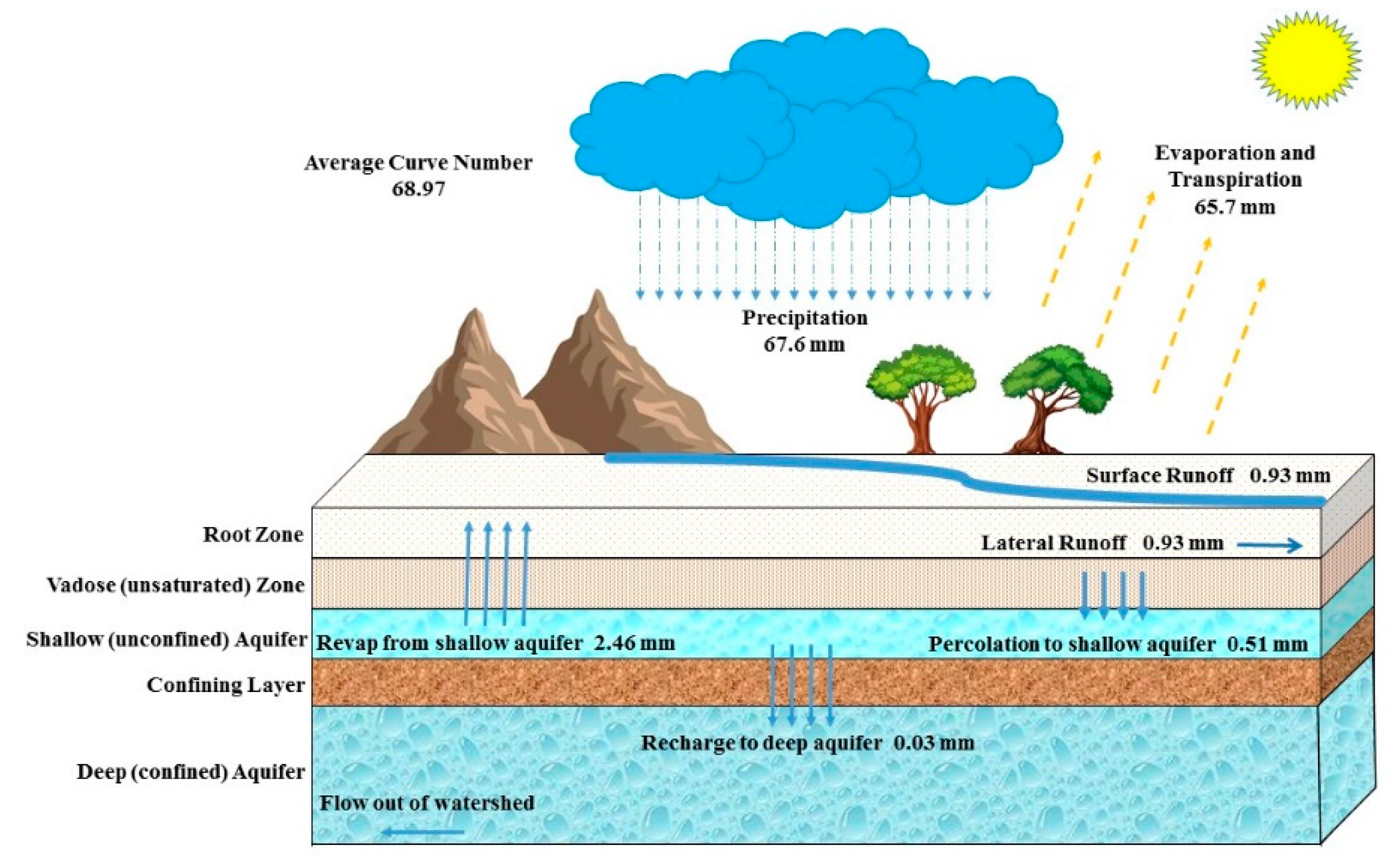
Given the demonstrably very low potential for surface infiltration, it is much more likely that the observed recovery of groundwater levels in the Arab/Jubaila aquifer is due to lateral flow within the aquifer. This recovery therefore represents a redistribution of “fossil” water within the aquifer. Accordingly, there is effectively no potential at present for sustainable groundwater extraction. Climate change, manifesting as an expected decrease in rainfall and increase in evaporation, is expected to only further unbalance the situation by reducing the potential for groundwater recharge.
Notably, the same rate of recovery seen in the Arab/Jubaila aquifer is not seen in the Biyadh aquifer (Figure 8). The low to non-existent recharge in the Biyadh aquifer is probably due to the lack of the high-permeability joints, fissures, and faults that are evident in the Arab/Jubaila aquifer and are likely to give rise to its high lateral flow rates. It is also likely that the Biyadh Formation’s matrix-porosity-dominated hydraulic flow units are heterogenous (as suggested by the wide range of porosity reported in section 3.1 7-37%) and poorly connected laterally, thus further reducing the potential for lateral recharge.
4.4. Predictioon of future groundwater levels
The changes in groundwater level in AK and WS illustrated in Figure 8 show the rapid decline and subsequent recovery of groundwater levels in the Arab/Jubaila aquifer. Notably, the Biyadh aquifer does not show the same recovery as the Arab/Jubaila aquifer. Figure 8 also shows how the extraction rates changed as the two areas went through two critical agricultural periods: the cultivation of wheat in the 1980s and the cultivation of alfalfa from 1992 to 2016. During the wheat cultivation period, groundwater levels decreased rapidly due to large quantities of irrigation water required for wheat. During the alfalfa cultivation period, groundwater levels decreased less rapidly, but significant groundwater depletion continued. However, at the beginning of 2016, the government of Saudi Arabia began banning alfalfa cultivation. This decision had an immediate effect, reducing groundwater overexploitation, as seen in the observation well records in Figure 8. The outcome of the groundwater modelling discussed in the previous concludes that his recharge is predominantly due to lateral redistribution of "fossil” groundwater, as surface infiltration is considered to be negligible.
During the five-year period following phase-out of alfalfa farming, the monitoring well groundwater level increased by 28 m in MW12, 11 m in MW15, 39 m in MW 80, and 3 m in MW Biyadh. Assuming that recovery continues at these rates, the estimated groundwater levels for 2025 and 2030 can be roughly predicted using the linear regression equations illustrated in Figure 8. The expected 2025 groundwater level in the Arab/Jubaila aquifer is -131 m in MW 12, -95 m in MW14, -82 m in MW 15, and -83 m in MW 80 (Figure 8). In 2030, the groundwater levels would be expected to increase to -106 m in MW 12, -73 m in MW 14, -71 m in MW 15, and -45 m in MW 80. Unfortunately, the data for the only monitoring well in the Biyadh aquifer yield an R2 value of 0.06, making prediction problematic. The expected 2025 and 2030 groundwater levels in the Biyadh aquifer are unknown given the poor correlation coefficient and the apparently negligible recovery indicated by recent data (Figure 8).
Figure 8.
Groundwater level (m) below the ground surface for four monitoring wells in Al Kharj from 1978 to 2021. During the period of wheat and alfalfa farming, groundwater was substantially depleted. In 2016 the groundwater level started to recover. The chart shows the constructed linear regression equations based on records from 2016 to 2021, the recovery period, to predict the groundwater level in 2025 and 2030.

5. Conclusions
The study area experienced two critical agricultural periods: wheat cultivation in the 1980s and alfalfa cultivation from 1992 to 2016. From 1978 to 2016, the agricultural sector subjected the Arab/Jubaila and Biyadh aquifers of the AK and WS areas, respectively, to significant overexploitation of fossil groundwater. The groundwater levels fell to 104 m below the ground surface in AK and 48 m below the ground surface in WS. Landsat images revealed a 66% reduction in agricultural land use during 1985 to 2020. The estimated total volume of groundwater withdrawal from the Arab/Jubaila and Biyadh aquifers were ~27 bcm. SWAT modeling exposed a very low potential for surface infiltration and recharge of depleted aquifers. The vast majority (97%) of the annual precipitation of 67.7 mm is expected to evaporate, 0.93 mm as surface runoff, percolation to the shallow aquifer is expected to be only ~0.51 mm, with negligible recharge to the deep aquifer. The 2016 phase-out of alfalfa farming resulted in the recovery of groundwater levels by an average of 26m in the Arab/Jubaila aquifer and 3m in the Biyadh aquifer. At current recovery rates, the average groundwater level for the Arab/Jubaila aquifer is expected to reach 98 m below ground level in 2025 and 74 m below ground level in 2030. Future work is required to investigate the impact of future global temperature increases on the study area’s aquifers.
Supplementary Materials
The following supporting information can be downloaded at the website of this paper posted on Preprints.org.
Author Contributions
The author confirms sole responsibility for the following: study conception and design, data collection, analysis and interpretation of results, and manuscript preparation.
Code and data availability
All data generated or analyzed during this study are included in this published article and its supplementary information file.
Acknowledgments
The authors extend their appreciation to Researchers Supporting Project number (RSPD2023R791), King Saud University, Riyadh, Saudi Arabia.
Competing interests
The author declares that there is no conflict of interest.
References
- Chitsaz, N.; Azarnivand, A. Water Scarcity Management in Arid Regions Based on an Extended Multiple Criteria Technique. Water Resour. Manag. 2016, 31, 233–250. [Google Scholar] [CrossRef]
- Sharafatmandrad, M.; Mashizi, A.K. Temporal and Spatial Assessment of Supply and Demand of the Water-yield Ecosystem Service for Water Scarcity Management in Arid to Semi-arid Ecosystems. Water Resour. Manag. 2020, 35, 63–82. [Google Scholar] [CrossRef]
- Llamas, R. , Custodio, E., Coleto, C., Huerga, A., and Cortina, L.: Intensive Use of Groundwater Challenges and Opportunities, A. A. Balkema Publishers, 2003.
- Richey, A.S.; Thomas, B.F.; Lo, M.-H.; Reager, J.T.; Famiglietti, J.S.; Voss, K.; Swenson, S.; Rodell, M. Quantifying renewable groundwater stress with GRACE. Water Resour. Res. 2015, 51, 5217–5238. [Google Scholar] [CrossRef] [PubMed]
- World data atlas. Available online: https://knoema.com/atlas (accessed on 5 May 2021).
- Awan, U.K.; Ismaeel, A. A new technique to map groundwater recharge in irrigated areas using a SWAT model under changing climate. J. Hydrol. 2014, 519, 1368–1382. [Google Scholar] [CrossRef]
- McDowall, A. : Saudi Arabia Doubles Private Sector Jobs in 30-Month Period. Al Arabiya, 19, 2014.
- General Authority for Statistics: The total population in 2018. Available online: https://www.stats.gov.sa/en/indicators/1 (accessed on 22 January 2021).
- Al-Harbi, T. G. and Hussein, M. T.: Statistical evaluation of groundwater quality in Wasia well Field, Saudi Arabia, J. King Saud Univ., 21, 125–135, 2009.
- Joodaki, G. , Wahr, J., and Swenson, S.: Estimating the human contribution to groundwater depletion in the Middle East, from GRACE data, land surface models, and well observations. Water Resour. Res. 2014, 50, 2679–2692. [Google Scholar] [CrossRef]
- Al Kadhi, A. A. and Hancock, P. L.: Structure of the Durma-Nisah segment of the Central Arabian graben system. Saudi Arab. Dir. Gen. Mineral. Resour. Min Res Bull. 1980, 16, 40. [Google Scholar]
- Alharbi, T.G.; Zaidi, F.K. Hydrochemical classification and multivariate statistical analysis of groundwater from Wadi Sahba area in central Saudi Arabia. Arab. J. Geosci. 2018, 11, 643. [Google Scholar] [CrossRef]
- Fallatah, O.A. Groundwater Quality Patterns and Spatiotemporal Change in Depletion in the Regions of the Arabian Shield and Arabian Shelf. Arab. J. Sci. Eng. 2020, 45, 341–350. [Google Scholar] [CrossRef]
- Zheng, T. : Applying Remote Sensing and GIS for Assessing Groundwater Impacts of Agriculture. Water Resources Management 2022, 36, 1787–1799. [Google Scholar] [CrossRef]
- Kumar, M.S.; Krishna, V.M. Estimating land use/land cover dynamics and biophysical parameters of South Nandi agricultural lands, Kenya using Landsat time-series. ISPRS Int. J. Geo-Inf. 2019, 11, 388. [Google Scholar] [CrossRef]
- Keller, M.; Bohnsack, D.; Koch, R.; Hinderer, M.; Hornung, J.; Al Ajmi, H.; Abu Amarah, B.; AlAnzi, H.; Rahmani, R.A.; Steel, R.J.; et al. Outcrop analog studies of the Wasia-Biyadh and Aruma aquifers in the Kingdom of Saudi Arabia, in: Siliciclastic reservoirs of the Arabian plate: AAPG Memoir, edited by: AlAnzi, H. R., Rahmani, R. A., Steel, R. J., and Soliman O. M., 116, 317–382, 2019. [CrossRef]
- Powers, R. W. , Ramirez, L. F., Redmond, C. D., and Elberg, E. L.: Geology of the Arabian Peninsula. Geol. Surv. Prof. Pap. 1966, 560, 1–147. [Google Scholar]
- Jaju, M.M.; Nader, F.H.; Roure, F.; Matenco, L. Optimal aquifers and reservoirs for CCS and EOR in the Kingdom of Saudi Arabia: an overview. Arab. J. Geosci. 2016, 9, 1–15. [Google Scholar] [CrossRef]
- Roure, F. , Amin, A., Khomsi, S. and Garni, M: Lithosphere Dynamics and Sedimentary Basins of the Arabian Plate and Surrounding Areas, Springer, Berlin, 2017.
- Al Kadhi, A. A. Structural and geomorphic evidence relevant to the neotectonic history of Central Arabia. J. College Sci., King Saud Uni. 1986, 17, 101–125. [Google Scholar]
- Eltom, H. , Abdullatif, O., Makkawi, M., and Abdulraziq, A.: Microporosity in the Upper Jurassic Arab-D carbonate reservoir, central Saudi Arabia: An outcrop analogue study. J. Petrol. Geol. 2013, 36, 281–297. [Google Scholar] [CrossRef]
- Abdlmutalib, A. and Abdullatif, O.: Multi-scale discontinuities characterization of the Arab-D and upper Jubaila tight carbonates outcrop, Central Saudi Arabia. Arab. J. Sci. Eng. 2017, 42, 2515–2538. [Google Scholar] [CrossRef]
- Weijermars, R. Plio-Quaternary Movement of the East Arabian Block. GeoArabia 1998, 3, 509–540. [Google Scholar] [CrossRef]
- Youssef, A. M. , Al-Harbi, H. M., Gutiérrez, F., Zabramwi, Y. A., Bulkhi, A. B., Zahrani, S. A., Bahamil, A. M., Zahrani, A. J., Otaibi, Z. A., El-Haddad, B. A.: Natural and human-induced sinkhole hazards in Saudi Arabia: Distribution, investigation, causes and impacts. Hydrogeol. J. 2016, 24, 625–644. [Google Scholar] [CrossRef]
- ener, A. , Yolcubal, İ., and Sanğu, E.: Determination of recharge, storage and flow characteristics of a karst aquifer using multi-method approaches (Kocaeli, Turkey). Hydrogeol. J. 2020, 28, 2141–2157. [Google Scholar] [CrossRef]
- Uitto, J. I. and Schneider, J.: Freshwater resources in arid lands, in: UNU Global Environmental Forum V, United Nations University Headquarters, Tokyo, , 1997. 13 June.
- Alsharhan, A.; Rizk, Z.; Nairn, A.; Bakhit, D.; Alhajari, S. Hydrogeology of an Arid Region: The Arabian Gulf and Adjoining Areas, Elsevier, Amsterdam, 2001. [CrossRef]
- Senapathi, V. , Viswanathan, P., and Chung, S.: GIS and Geostatistical Techniques for Groundwater Science, Elsevier, 2019.
- Huang, S. , Tang, L., Hupy, J. P., Wang, Y., and Shao, G.:. A commentary review on the use of normalized difference vegetation index (NDVI) in the era of popular remote sensing. J. For. Res. 2021, 32, 1–6. [Google Scholar] [CrossRef]
- Lindsay, R. F., D. L. Cantrell, G. W. Hughes, T. H. Keith, H. W. Mueller III, and S. D. Russell.: Ghawar Arab-D reservoir: Widespread porosity in shoaling-upward carbonate cycles, Saudi Arabia, in P. M. Harris and L. J. Weber, eds., Giant hydrocarbon reservoirs of the world: From rocks to reservoir characterization and modeling: AAPG Memoir 88/ SEPM Special Publication, p. 97–137, 2006.
- Bureau de Recherches Géologiques et Minières: Detailed Water Resources Studies of Wasia-Biyadh and Aruma Aquifers; Ministry of Agriculture and Water, Water Resources Development Department, Riyadh, Saudi Arabia 158, 2011.
- Gassman, P. W. , Reyes, M. R., Green, C. H., and Arnold, J. G. : The soil and water assessment tool: Historical development, applications, and future research directions. Trans. ASABE 2007, 50, 1211–1250. [Google Scholar] [CrossRef]
- Soil Conservation Service: National engineering handbook, section 4: Hydrology, United States Soil Conservation Service, United States Department of Agriculture, Washington, DC, 1985.
- McCarthy, G. T. : The unit hydrograph and flood routing, Conference of North Atlantic Division, US Army Corps of Engineers, New London, CT. US Engineering, France, 1938.
- Jarrett, R. D. : Hydraulics of high-gradient streams. J. Hydraul. Eng. 1984, 110, 1519–1539. [Google Scholar] [CrossRef]
Figure 1.
(a) Annual water withdrawal in billions of m3 (bcm) per year, in Saudi Arabia. The agriculture sector is the majority consumer of water. (b) Water withdrawals as percentages of total freshwater. The agriculture sector uses 82% of the total freshwater.
Figure 1.
(a) Annual water withdrawal in billions of m3 (bcm) per year, in Saudi Arabia. The agriculture sector is the majority consumer of water. (b) Water withdrawals as percentages of total freshwater. The agriculture sector uses 82% of the total freshwater.
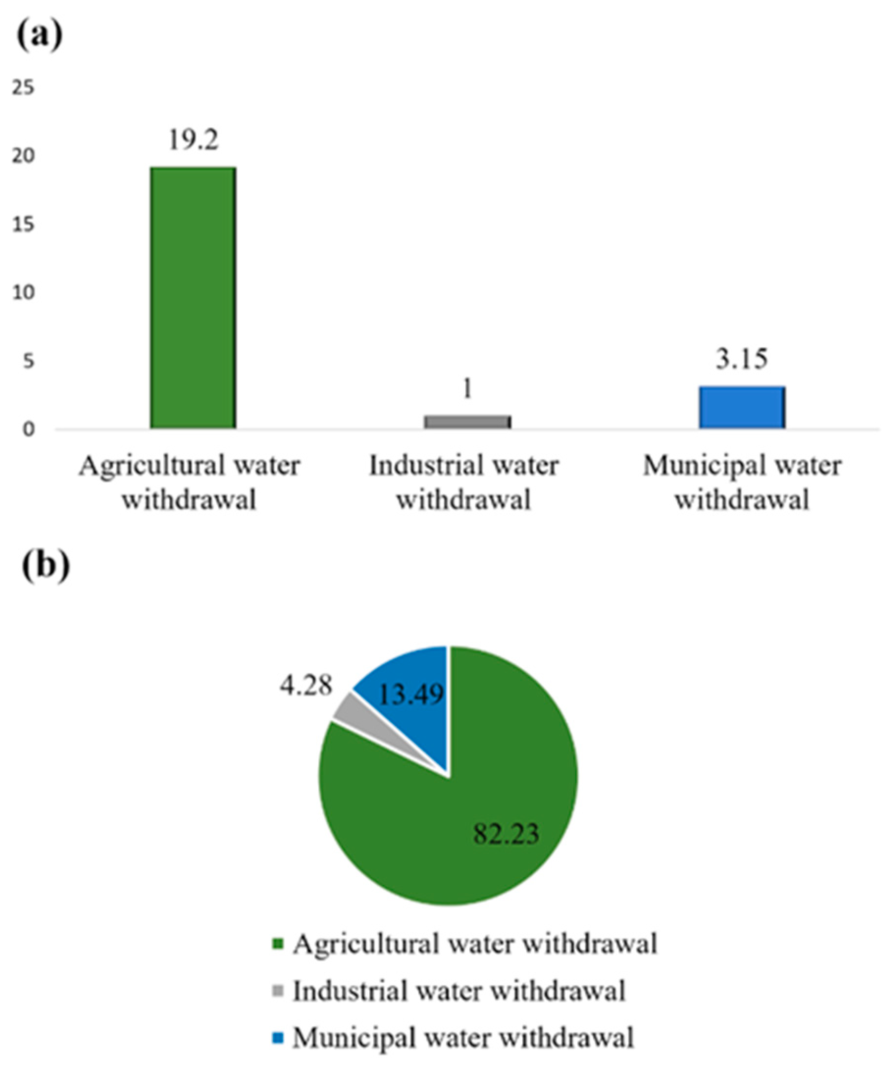
Figure 2.
(a) Map showing the location of the study area in Saudi Arabia. (b) Location map of the major cities and the study area. (c) Map showing the boundaries of Al Kharj (red) and Wadi Sahba (black) and the locations of the monitoring wells.
Figure 2.
(a) Map showing the location of the study area in Saudi Arabia. (b) Location map of the major cities and the study area. (c) Map showing the boundaries of Al Kharj (red) and Wadi Sahba (black) and the locations of the monitoring wells.
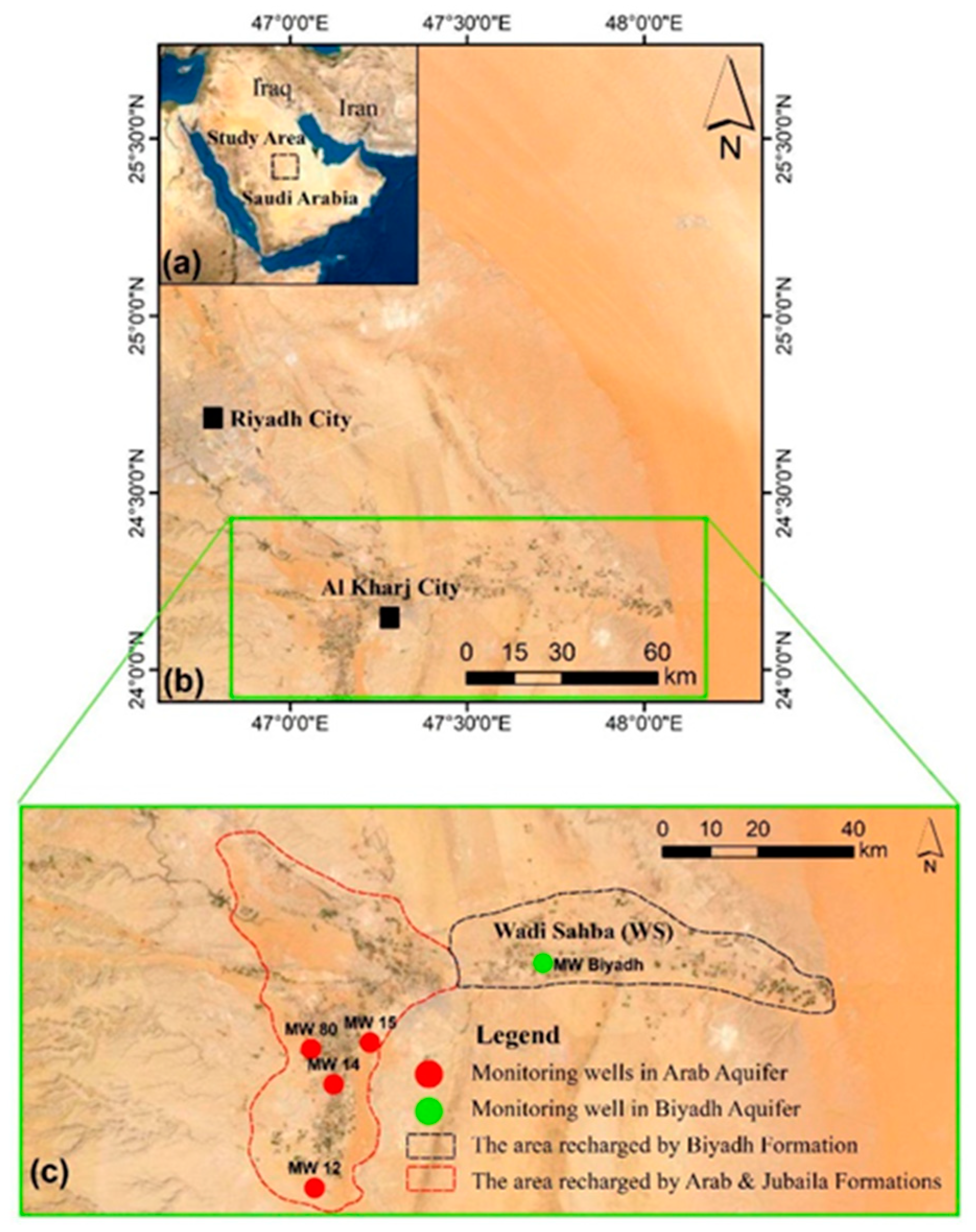
Figure 3.
(a) Geological map of the study area’s main formations, including the Arab Formation (light blue) and Jubaila Formation (dark blue) in the west and the Biyadh Formation (light green) in the center of the map. (b) Generalized stratigraphic column shows the vertical sequence of formations with their ages, thicknesses, and lithologic descriptions.
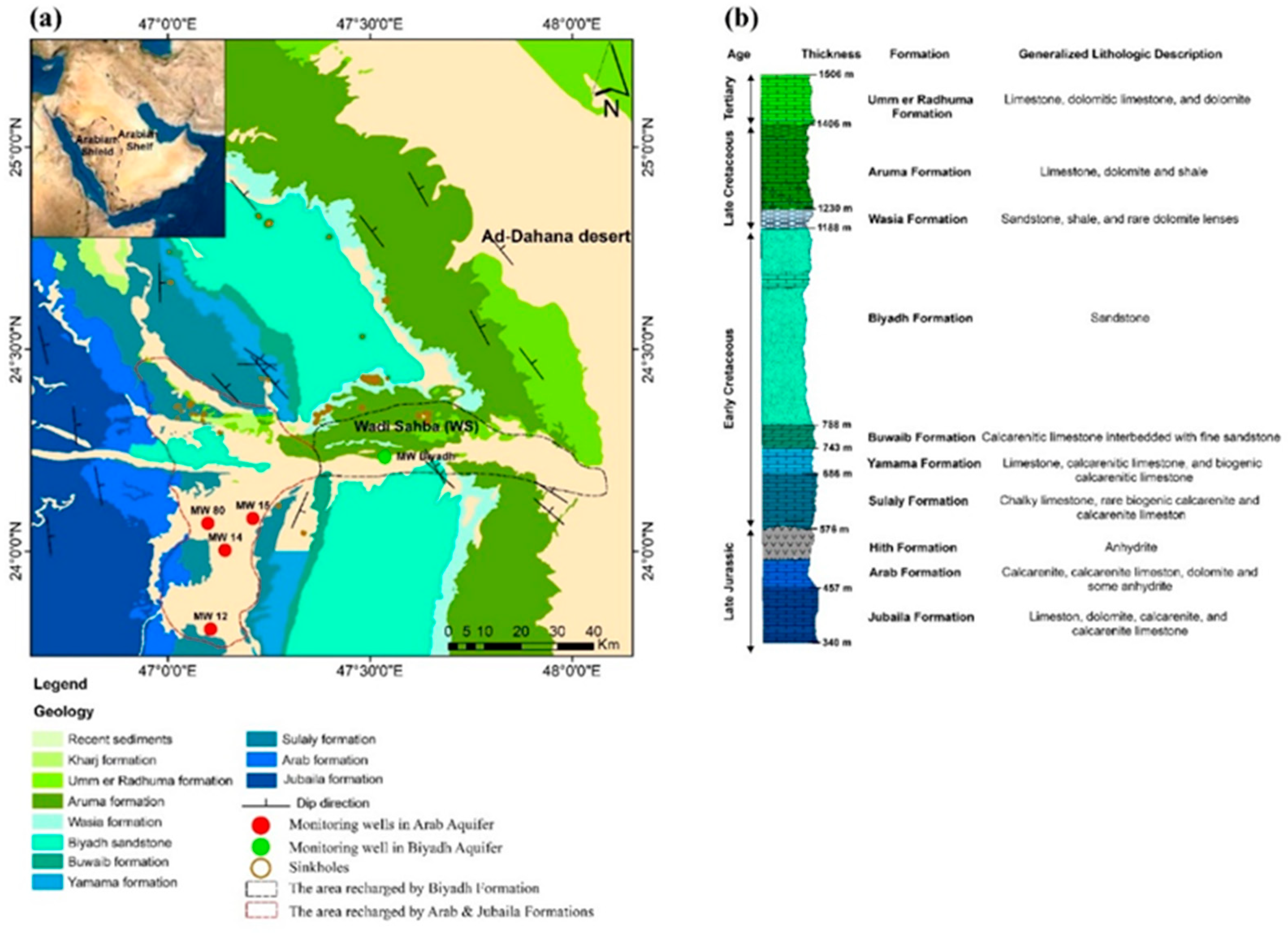
Figure 4.
(a) Map showing the location of the main watershed in central Saudi Arabia. (b) Map showing the watershed (112298 km2 in area) with ephemeral streams flowing east toward the study area and the location of the rainfall stations with their average annual rainfall (red). (c) Map showing the digital elevation model (DEM) and the location of the Al Kharj and Wadi Sahba boundaries and the monitoring wells. Al Kharj and Wadi Sahba are located in the part of the study area whose elevation is relatively low.
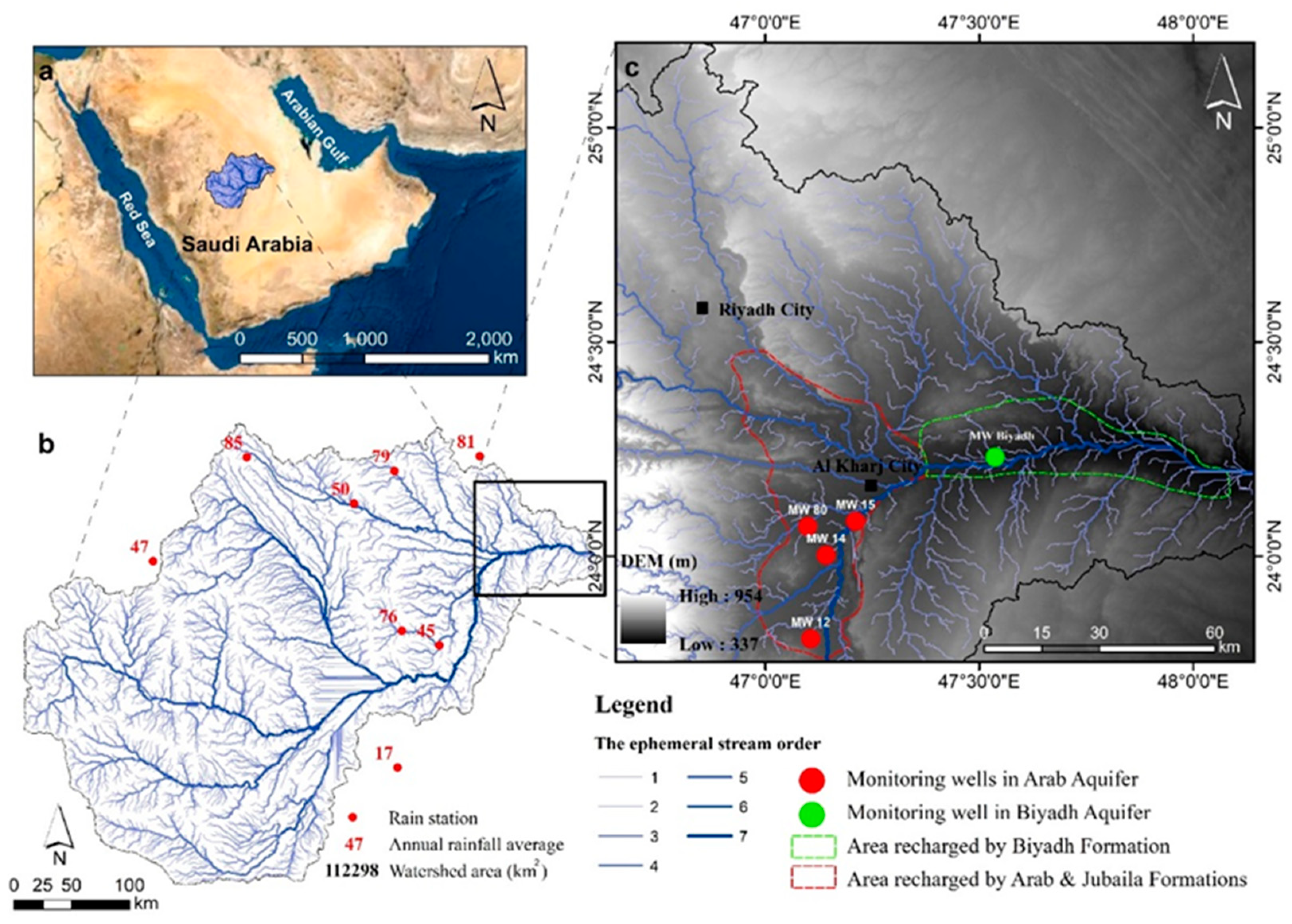
Figure 5.
Visible cavities in an outcrop of the Jubaila Formation. (b) Long joints in an Arab Formation outcrop. (c) Long joints 30 cm wide in a Jubaila Formation outcrop. (d) Karren features in limestone. (f) Biyadh Sandstone outcrop in the study area.
Figure 5.
Visible cavities in an outcrop of the Jubaila Formation. (b) Long joints in an Arab Formation outcrop. (c) Long joints 30 cm wide in a Jubaila Formation outcrop. (d) Karren features in limestone. (f) Biyadh Sandstone outcrop in the study area.
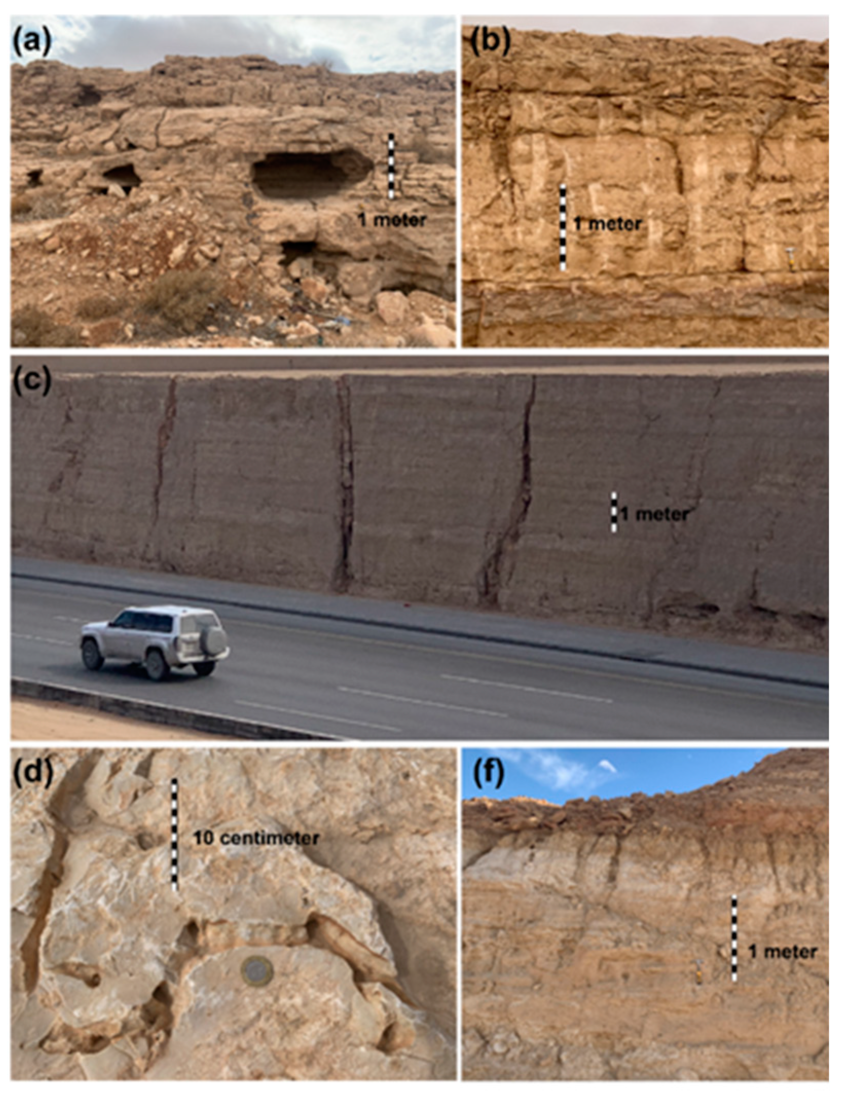
Figure 6.
(a and b) Landsat images show the extent of agricultural lands in Al Kharj and Wadi Sahba for 1985 and 2020. (c) Map showing polygons for the agricultural areas classified based on the Normalized Difference Vegetation Index (=< 0.2) for 1985 and 2020. The agricultural land area decreased 66% from 645 to 217 km2.
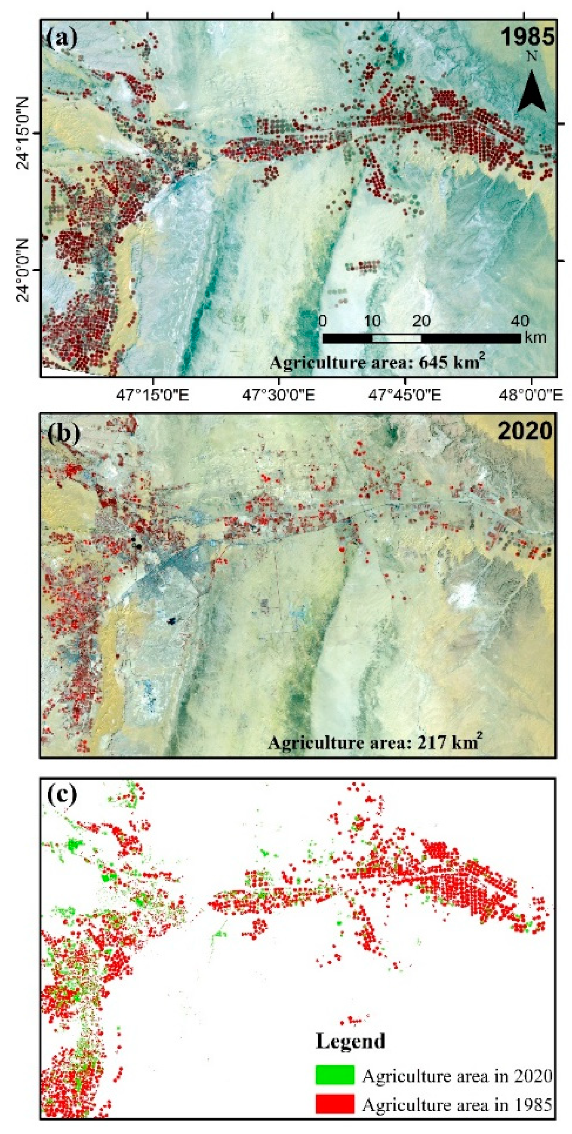

Table 1.
List of parameters used for running the Soil and Water Assessment Tool model.
| Parameter | Value | Definition |
|---|---|---|
| ALPHA_BF | 1.0 | Base flow alpha factor (days) |
| CH_K | 150 | Effective hydraulic conductivity in channel alluvium (mm h−1) |
| SURLAG | 15.0 | Surface runoff lag coefficient (days) |
| SOL_AWC | Varies (0.01–0.50) | Available water capacity of the soil layer (mm/mm soil) |
| SOL_K | Varies (0.5–10) | Saturated hydraulic conductivity (mm h−1) |
| CH_N1 | Varies (0.035–0.05) | Manning’s n value for the tributary channels |
| CH_N2 | Varies (0.035–0.05) | Mannings’s n value for the main channel |
| CANMX | 0.0 | Maximum canopy index |
| SOL_Z | Varies (1–1000) | Soil depth (mm) |
| GW_DELAY | 0.0 | Groundwater delay time (days) |
| GWQMN | 2,000 | Threshold depth of water in the shallow aquifer required for return to occur (mm H2O) |
| CN (Alluvial) | 39 | SCS curve number |
| CN (Sandstone) | 61 | SCS curve number |
| CN (Limestone) | 74 | SCS curve number |
| CN (Precambrian) | 80 | SCS curve number |
Disclaimer/Publisher’s Note: The statements, opinions and data contained in all publications are solely those of the individual author(s) and contributor(s) and not of MDPI and/or the editor(s). MDPI and/or the editor(s) disclaim responsibility for any injury to people or property resulting from any ideas, methods, instructions or products referred to in the content. |
© 2023 by the author. Licensee MDPI, Basel, Switzerland. This article is an open access article distributed under the terms and conditions of the Creative Commons Attribution (CC BY) license (https://creativecommons.org/licenses/by/4.0/).
Copyright: This open access article is published under a Creative Commons CC BY 4.0 license, which permit the free download, distribution, and reuse, provided that the author and preprint are cited in any reuse.


