Submitted:
17 July 2023
Posted:
18 July 2023
You are already at the latest version
Abstract
The campuses of Nigerian universities especially the old ones, like the University of Ibadan, comprise old trees which can pose a threat to pedestrians, structures, and roads within the school environments. However, there is no adequate information on these avenue trees thereby impeding their sustainable management. Therefore, this study provides the basic information needed by developing a geodatabase for the avenue trees along Benue, Emotan and Oduduwa roads within the University of Ibadan, Ibadan, Nigeria. The coordinates of all the avenue trees, and some within the selected roads were obtained. Tree growth data collected include; diameter at the breast height (dbh), diameter at the base, middle and at the top, crown height, crown diameter, and total height of all the avenue trees. Tree visual evaluation for diseases (TVED) was carried out for root decay, and termite attack on any part of the tree (stem, leaves and visible part of the root). Risk rate was assessed as low, medium and high, depending on the potential target (human, vehicles, structures). The risk rate depended on the incidence of leaning towards a building or road, cracked branches, root attack by termites, basal decay or branch decay. The growth data were used to compute the tree volume while the avenue trees were georeferenced. The physical health status of the avenue trees was determined using TVED data. The spatial distribution of the avenue trees was developed in GIS while all the analysed data were pulled together to develop a geodatabase for the avenue tress using design templates of BOOTSTRAP, comprising of Hypertext Markup Language, Cascade Style Sheets, JavaScripts and Hypertext Preprocessor. A total of 121 individual avenue trees belonging to 14 species were identified in the study area. The analysis of the geospatial distribution shows that Emotan Road had a lesser spatial distribution of avenue trees compared to Benue and Oduduwa roads. Furthermore, the health risk assessment of the trees in the study area indicated that 17.35% of the individual avenue trees had defects. The database created is user-friendly, suitable and has the ability for easy data storage and quick information retrieval on the avenue trees to enhance their maintenance and risk management. This can be accessed using the link http://159.203.29.155/rebs/rebs.php.
Keywords:
Geodatabase
; Health risk assessment
; Spatial distribution
; Avenue trees
Introduction
Due to rapid urbanization and its deleterious impact on the climate, environments and human wellbeing, there has been a growing recognition and interest of urban planners and managers in urban greening and urban forestry (Zhao et al., 2006). Of all the components of urban forests and green spaces, avenue trees are of great relevance and an essential element to urbanized environments and contexts. Avenue trees or roadside trees are plants with a woody stem or trunk growing all, or in part, within the surfaces side of a public road (Anon., 2005). These are the trees along the roadsides, pathways and highways, which are most effective in providing shade to adjacent urban elements. Roadside or avenue vegetation possess an attribute of exhibiting visual contrast between dense landscaping and open space especially when established in groups (Desai and Nandikar, 2012). Planting of avenue trees along both sides of roads offer substantial aesthetic and utilitarian values (Schroeder, 2011). Beautiful, coloured flowers of these trees augment the beauty of the surroundings. Their standing stems and green foliage also tend to enhance the architectural and aesthetic layout of an otherwise gray urban environment, especially when systematically planted along the roadside.
Furthermore, avenue trees are attributed to great economic benefits, with an increasing interest and methods in quantifying and assessing them (Killicoat et al., 2002; Isaifan and Baldauf, 2020). They reduce air temperature, cool the urban air, and provide shade and thermal comfort to building surfaces within urban areas, which thus saves energy use costs of air-conditioning and cooling in neighbouring homes (Gallagher et al., 2015; Baldauf, 2017; Agbelade et al., 2022). The roadside trees also remove gaseous air pollutants and airborne suspended particulate matter like dust particles from the atmosphere e.g., through deposition in their canopy, thus improving local air quality. The metric tons of air pollution removal by avenue trees have high contingent financial values across different cities in the world (Killicoat et al., 2002; Isaifan and Baldauf, 2020). Avenue trees also help to ameliorate noise pollution and increase the property values in the urban areas, thereby generating some real estate values. These trees tend to control wind speed, reduce runoff around the urban environments, and can offer provisioning and nutritional services such as fruits to urban dwellers and road users (Killicoat et al., 2002; Agbelade et al., 2022). They can also sometime help reduce vehicular speeds on the municipal roads by providing a sense of signage and traffic signal to drivers, although requires that they are properly designed and integrated in the streetscapes to prevent car/tree crashes and facilitate traffic safety (Wolf and Bratton, 2006). The health benefits of avenue trees have also been largely investigated. Roadside trees do not only reduce mental and physical tiredness but also give psychological satisfaction (Pals et al., 2009; Hipp and Ogunseitan, 2011; Beyer et al., 2014). Elsadek et al. (2019), in a field experiment in Shanghai, assessed the psychological benefits of avenue trees on pedestrians. They observed a significant improvement in the psychological states of tension, fatigue, and anxiety as well as enhanced restorative outcome and vitality due to short walks along urban roads with avenue trees.
Various studies have been carried out on avenue trees with a predominant focus on their health benefits, environmental-economic values, occurrence, relative abundance, public perceptions, regeneration classes and management recommendations, globally (e.g., Killicoat et al., 2002; Beyer et al., 2014; Elsadek et al., 2019; Isaifan and Baldauf, 2020) and across Nigeria (Faleyimu, 2017; Agbelade and Onyekwelu, 2020; Agbelade et al., 2022). However, there is limited information in their spatial distribution, which of course will help to know where precisely the tree species are located, distance between successive trees, their arrangements, and their health status. Spatial inventory information of the avenue trees is crucial to accurately inform decision making needs for instance, in terms of tree management, enrichment planting and how many seedlings will be needed. Avenue trees can pose significant health risks and challenges to pedestrians and adjacent infrastructures, especially in areas with considerable anthropogenic pressures (such as mechanical damage, soil compaction) or inadequate maintenance, planning and management (Klein et al., 2019; Suchocka et al., 2022). Avenue trees are more vulnerable to extreme adverse conditions than many other urban forest elements, due to their exposure to mechanical damages from pedestrians and moving vehicles. Other abiotic and biotic stressors (such as insect pests and pathogens) also directly, largely impact the health of these valuable urban trees. They are prone to defoliation, staining, boring, loss of branches, and developing deformities like hollows, cavities, decays, which all pose increased risks of failure to nearby people, cars, properties, utilities, and disruption of activities (Li et al., 2022; Suchocka et al., 2022).
The existence and utilization of avenue trees without tree risk assessment may be disastrous to the environment (Kuchelmeister 1998; Aiyeloja, et al., 2011; Li et al., 2022), and the accuracy of such risk assessment can be potentially enhanced by the availability of up-to-date spatial information of the trees. Urban (avenue) tree failures are not uncommon in municipal areas around the world (Suchocka et al., 2022), which is also not an exemption in Nigerian metropolises (Eludoyin et al., 2021). In the University of Ibadan, where this study was conducted, tree failures sometime occur along some roads like Benue Road, with trees falling and obstructing vehicular movement for over a couple of days before clearance. To a large extent, documentation on the health status and the level of risk the individual avenue tree in the study area is scarce. Where they may be available, they are not in form of data bank, which can facilitate efficient data storage and prompt information retrieval such that at a mouse click, relevant information about the individual trees can easily be accessed. Eludoyin et al. (2021) assessed the risks levels of trees along the road and residential area of the University Park of the University of Port Harcourt and observed a high proportion (up to 63%) of the trees posing moderate risks. Onefeli et al. (2012), on the other hand, selectively classified and investigated the physical health of some avenue trees in the University of Ibadan’s environment, reporting a considerable tree diversity in the area.
However, there is limited in-depth studies on the geospatial distribution, health, and risk assessment of avenue trees along the most-engaged roads within the study area. Neither has there been any development of database management system for the avenue trees within this region. Effectively managing trees growing along pedestrian routes require such a system that allows adequate inventory, updating and retrieval of tree information and risk assessment. This study therefore aimed to bridge the knowledge gap by providing information on the identification, spatial distribution, health and risk assessment of avenue trees within selected roads in the oldest and prominent urban university environment in the West-African country.
Materials and Methods
Study Area
The study was conducted along Odudua, Emotan, and Benue roads of the University of Ibadan, situated in the Ibadan North Local Government Area of Oyo State. This area, located approximately 277 meters above sea level, experiences distinct rainy and dry seasons. The rainy season spans from late March to late October, bringing a mean annual rainfall of about 1220mm. It exhibits a double peak pattern, with the first peak occurring in June, followed by a short break, and the second peak in September. On the other hand, the dry season lasts from November to March and is influenced by the North-East trade winds, lasting for 4-5 months. During the rainy season, relative humidity is notably high, while it decreases during the dry season. Cloud cover during the rainy season can reduce sunlight intensity, thus impacting the area's temperature. The soil in the study area is predominantly sandy loam, with clay and the presence of large stones and gravel in various locations. Although the soil texture is generally poor, it is well drained, and rock outcrops can be found within the plantation. The terrain consists of wavelike slopes that run from west to east. (Akinyele et al., 2013).
Data Collection
Dendrometric, spatial and health status data were collected directly on all the avenue trees along the selected roads (i.e., Odudua, Emotan, and Benue roads) in the University area. Primary tree data collected from the roads included the coordinates of all the avenue trees, crown height (m), crown diameter (cm), diameter at breast height (dbh, cm) of all the avenue trees, and Diameter at the base, middle and at the top (cm), total height (m) of individual trees. These tree variables were enumerated accordingly using diameter tape, Spiegel relascope, meter tape, and a Global Positioning System. Each individual avenue tree was determined to species name employing the service of a taxonomist. Total enumeration of all the avenue trees was carried out. Tree risk or vitality assessment can be done using different methods from basic visual to more advanced techniques. As reported by Suchocka et al. (2022), some of the most commonly used methods are Visual Tree Assessment (VTA), Tree Visual Evaluation Diseases (TVED), and ISA Tree Risk Assessment Qualification (TRAQ). These methods typically involve visual evaluation of the overall health and condition of trees for visible signs of structural defects, diseases, pests, or other issues that may affect tree health and stability. The use of visual assessment methods by an arborist is considered a reliable evidence of tree hazard potential. Therefore, with the assistance of experienced arborist, we diagnosed the tree diseases and health status of each avenue tree enumerated based on the tree visual evaluation diseases (TVED) method using risk rate. The avenue trees were evaluated for diseases such as root decay, termite attack on any part of the tree; usually the basal portion and leaves as well as crown status, etc. Risk rate was assessed as low, medium and high, depending on potential target (human, vehicles, properties, etc.). Risk rate depended on incidence of leaning towards building or road, cracked branches, root attack by termites, basal decay, or branch decay, etc.
Data Analysis
The data collected on the avenue trees along the three roads in the study area were subjected to analysis, which was mainly carried out in the Quantum Geographic Information (QGIS) environment. The analysis procedure included: generation of map of the selected roads using the coordinates obtained from Global Positioning System (GPS), and the production of individual avenue trees map with respect to their location on the generated map of the study area. Also, roads were digitized with lines of various thickness, various sections of the land use and buildings were represented with polygons of various sizes while avenue trees were represented with points on the map. The collated data set of the individual avenue trees was developed to form a database file using MySQL for easy accessibility. Before the database file development, the tree diameter data (at the top, middle and base) and total height obtained were accordingly employed to compute their volume using Newton’s formula (Eq. 1), which is consistent with Agbelade and Onyekwelu (2020).
where: V = Tree volume (m3), Db, Dm and Dt = tree cross-sectional area (m2) at the base, middle and top of merchantable height, respectively, and h = total height (in meters).
The database development involved three phases: back end, interphase, and front end. The Back End is known as the Data Access Layer (DAL) which comprises of rows and columns where data are set up. This allows one to query database and give results without errors. The back end is usually created using Bootstrap which is a free and open source collection of tools comprising of Hypertext Markup Language (HTML), cascade style sheets (CSS), JavaScript and Hypertext Preprocessor (PHP) application formerly known as Personal Home Page with each of the tools performing different functions. The Interphase, also known as the business logic layer (BLL), is the layer which allows the designer to input, delete, select, and update data into the database. PHP is the programming language handling the interphase. It gets information from the front end where the users interact with the software into the database and returns the result back to the front end. The Front End is referred to as the Presentation Layer (PL) where users directly interact with the website and database and obtain information about the avenue trees. The users can access information without using a structured query language known as SQL.
Results
Geospatial Distribution and Structural Attributes of Avenue Trees within Benue, Emotan and Odudua Roads
Figure 1 shows the spatial distribution of avenue tress in Benue, Emotan and Oduduwa roads. Benue road lies at the north-western part of the University with the avenue tress scattered along the road without any regular pattern. Oduduwa road on the other hand, is situated at the south-eastern part of the University while Emotan road is situated at the centre, joining the base of Benue road.
We analysed the structural characteristics of the avenue trees (Table 1). Odudua road recorded the highest number of species (9) followed by Benue road with species richness value of 8. Emotan road had the least species abundance and diversity with only 4 individual avenue trees belonging to two (2) species: Mangifera indica and Peltophorum pterocarpum. Accordingly, Odudua road had the highest values of tree structural variables: volume (84.25 m3), crown diameter (1371.55 cm), total height (1371.55 m) and merchantable height (698 m), as presented in Table 1, despite having lesser number of individual trees (58) than Benue road with 59 trees. Overall, a total of 121 avenue trees were identified along the three selected roads in the university environment.
Table 2, Table 3 and Table 4 further present the specific tree species and structural attributes of the roadside trees along each of the roads, respectively. Casuarina equisetifolia and Samanea saman were observed to be the most abundant species along Odudua road, with 16 and 14 individual trees respectively. However, quite surprisingly, these two species were absent and not found along the other two roads. Peltophorum pterocarpum had the largest tree size in Ododua road with a mean DBH of 56.25 cm but was second to Mangifera indica (65.0 cm) in Emotan road with only one individual tree. Nonetheless, the highest DBH values were obtained on tree species along Benue roads, with trees as large as 70 cm averagely (as in Rucinodendron heudelottii). Samanea Saman and Peltophorum pterocarpum reported the highest species volume (34.08 m3 and 22.77 m3) in Odudua and Benue roads, while Taberbuia rosea (0.17 m3) and Phyllanthus discoideus (0.56 m3) had the lowest volume yields, respectively.
Health Status of Avenue Trees along Odudua, Emotan and Benue Roads in the University of Ibadan, Nigeria
The health and risk status of the avenue trees along the three selected roads in the University of Ibadan, based on the Tree Visual Evaluation Diseases (TVED) method, is presented in Figure 2, Figure 3 and Figure 4. The risk rating of the individual tree species for termite infestation, butt decay, leaf decay, leaning angle, cracked branch, and branch decay was assessed on four levels based on the severity of the defects, infestations, and infections. It was observed that the majority of the tree species along Benue road possessed low rate of tree defects with a few species like Peltophorum pterocarpum and Ricinodendron heudelottii having defects at a medium rate, which however varied across the diseases. Although some species recorded no individuals affected by certain decay or infestation, such as Delonix regia which experienced no termite attack, cracked branch, and branch decay; only Phyllanthus discoideus showed no sign of tree defect across all health categories considered (Figure 2).
Of all the six (6) tree defects investigated on the two avenue tree species found along Emotan roads, only termite infestation and butt decay were present (Figure 3). While Peltophorum pterocarpum was infected by both tree defects, Mangifera indica was infested only by termites. Both decay and infestation were however observed at low rate and could be properly managed with less potential risk hazard to pedestrians and utilities along the road. Figure 4 indicates that the majority of the tree species within Odudua road exhibited low rate of tree defects with few species having defects at medium rate; thus, posing low-moderate risks and hazards to people, buildings, and other nearby urban utilities. Only one species (i.e., Peltophorum pterocarpum) had an individual tree with a high rate of termite infestation and necessitated immediate risk management intervention. Taberbuia rosea, on the other hand, showed no sign of tree defect across all categories.
Geodatabase for Avenue Trees within Benue, Emotan and Odudua roads
Home Page
The homepage can be referred to as the front end because this portion of the database is where users can have access to information on the database via internet using the link http://159.203.29.155/rebs/rebs.php. It provides detailed information on the avenue trees within these three locations depending on what is being queried out by the user. The information are grouped into three main sections; locations, tree species and health status. Also, information of each avenue trees in terms of coordinates, frequency and geospatial distribution were included (Figure 5). On selection on the right-hand corner of the front page for example, it navigates to the information of a specific avenue tree (e.g., Casuarina equisetifolia in Figure 6).
Discussion
From the results obtained across the three roads, it was found that the variables differed even within the same species. Odudua road had the highest tree volume, which is a basic parameter used to determine tree size. Trees with high volume value indicate large size, which holds significant economic value. Additionally, Odudua road exhibited the highest crown length, which is influenced by total height and merchantable height. This indicates a more branchy tree with a substantial crown, essential for providing shade in urban areas, which is a vital function of urban trees (Killicoat et al., 2002; Agbelade et al., 2022). Furthermore, the road also displayed a high crown diameter, which extends the canopy cover and contributes to the aesthetic value provided by the tree. It was observed that trees with larger leaves and high crown diameter tend to have greater crown length. The total height of the tree is a significant factor in distinguishing trees from shrubs. Trees with a total height value lower than the Diameter at the breast height (Dbh) generally have a lower slenderness coefficient (Nunes et al., 2010). Merchantable height is important in determining crown length; lower volumes of merchantable height correspond to increased crown length, indicating increased tree branchiness. Odudua road had the largest values due to its longer length compared to Emotan road (98 m), although Benue road is the longest (1,020 m), the construction of the millennium park consumed a significant portion of it.
In terms of the physical health assessment variables considered (termite infestation, butt decay, leaf decay, leaning angle, cracked branch, and branch decay), the rates of tree species with high infestation and decay were few, while those with medium infestation and decay were limited. A large percentage of the avenue trees showed no signs of infestation, decay, or deformity. Out of the 121 trees assessed, only 21 exhibited some defects, posing potential hazards and risks of tree failure and damage to pedestrians, vehicles, and neighbouring utilities. Tree failures have the potential of causing substantial damage to properties, disrupting services, activities, and movement, or threatening public safety (Li et al., 2022; Suchocka et al., 2022). According to Klein et al. (2019), even a low-risk rate of urban trees still requires appropriate management and maintenance. Therefore, based on our findings, it is recommended that tree management practices be implemented for the avenue trees within these three locations and other regions of the urban university environs. These recommendations align with the findings of Onefeli et al. (2012), who assessed trees within the Faculty of Agriculture and Forestry in the same study campus and reported the need for prompt intervention in the majority of individual tree species.
Furthermore, the developed database system in this study is internet-based and hosted on the website link http://159.203.29.155/rebs/rebs.php. It documents information on the geospatial distribution and health risk assessment of avenue trees along Odudua, Emotan, and Benue roads. This database serves as an efficient support tool for assessing and retrieving information regarding the structural and geospatial dynamics, as well as the health and risk status of individual avenue tree species along the selected roads. Accessible information will facilitate prompt and efficient maintenance and management decisions by the University Tree Management committee. The database can be easily updated as new information is gathered and allows for modifications through the link http://159.203.29.155/phpmyadmin/. Access to the database is password-protected to prevent unauthorized entry and ensure the information on the website is verified and reliable. Currently, the database is undergoing revamping to improve its functionality, and access may be restricted during this period.
Conclusion
This study has revealed the spatial distribution and health status of the avenue trees along three commonly plied roads within the University of Ibadan. Basic information needed for management purpose, academic purpose and further research purpose have been provided. The internet-based database developed in this study is adequate. It has provision for regular updates and subscription. The data integrity is high, and all users can be monitored as they subscribe to the database. Their activities can also be monitored through the internet.
Funding
No funding was received for this research work.
Acknowledgments
We would like to appreciate the personnel at the Department of Social and Environmental Forestry, Faculty of Renewable natural Resources, University of Ibadan for their assistance towards this research work. We would also like to thank Mr. Tomiwa Oluwajuwon and other anonymous reviewers who gave edit input to improve the initial draft.
Conflict of Interest
The authors declare that they have no conflict of interest.
References
- Agbelade, A. D., & Onyekwelu, J. C. (2020). Tree species diversity, volume yield, biomass and carbon sequestration in urban forests in two Nigerian cities. Urban Ecosystems, 23, 957-970. [CrossRef]
- Agbelade, A. D., Onyekwelu, J. C., John, A. A., Adedayo, J., & Alabi, T. (2022). Assessing the conservation status, biodiversity potentials and economic contribution of urban tree Ecosystems in Nigerian Cities. Urban Ecosystems, 1-14. [CrossRef]
- Aiyeloja, A. A., Ogunsanwo, O.Y. & Asiyanbi, A.P. (2011): Determinants of Preference for Lesser-Known Species among Cabinet-Makers in Oyo and Osun States, Nigeria. Small-scale Forestry 10:37–51. [CrossRef]
- Akinyele A.O, Adegeye A.O, Jimoh S.O, & Olajuyigbe S.O (2013). Tree species diversity in the department of forest resources management, university of Ibadan, Nigeria, African Journal of Sustainable Development.
- Anonymous (2005). Natural Resources Article: Roadside Tree Care. Department of Natural Resources, Maryland.
- Baldauf, R. (2017). Roadside vegetation design characteristics that can improve local, near-road air quality. Transportation research part D: Transport and environment, 52, 354-361. [CrossRef]
- Beyer, K. M., Kaltenbach, A., Szabo, A., Bogar, S., Nieto, F. J., & Malecki, K. M. (2014). Exposure to neighborhood green space and mental health: evidence from the survey of the health of Wisconsin. International journal of environmental research and public health, 11(3), 3453-3472. [CrossRef]
- Desai, T. B., & Nandikar, M. (2012). Impact of urbanization on avenue trees and its role in carbon sequestration: a case study in Kolhapur city. International journal of environmental sciences, 3(1), 481-486.
- Elsadek, M., Liu, B., Lian, Z., & Xie, J. (2019). The influence of urban roadside trees and their physical environment on stress relief measures: A field experiment in Shanghai. Urban Forestry & Urban Greening, 42, 51-60. [CrossRef]
- Eludoyin, O. S., Ogundele, A. T., & Abu, A. P. (2021). Risk assessment of ornamental trees in university park, University of Port Harcourt, Rivers State, Nigeria. International Journal of Advanced Academic Research 7(11).
- Faleyimu, O. I. (2014). Public perceptions of urban forests in Okitipupa Nigeria: implication for environmental conservation. Journal of Applied Sciences and Environmental Management, 18(3), 469-478.
- Gallagher, J., Baldauf, R., Fuller, C. H., Kumar, P., Gill, L. W., & McNabola, A. (2015). Passive methods for improving air quality in the built environment: A review of porous and solid barriers. Atmospheric environment, 120, 61-70. [CrossRef]
- Hipp, J.A., & Ogunseitan, O.A. Effect of environmental conditions on perceived psychological restorativeness of coastal parks.J. Environ. Psychol. 2011, 31,421- 429. [CrossRef]
- Isaifan, R. J., & Baldauf, R. W. (2020). Estimating economic and environmental benefits of urban trees in desert regions. Frontiers in Ecology and Evolution, 8, 16. [CrossRef]
- Killicoat, P., Puzio, E., & Stringer, R. (2002). The economic value of trees in urban areas: estimating the benefits of Adelaide’s street trees. In Proceedings Treenet Symposium (Vol. 94, p. 106).
- Klein, R. W., Koeser, A. K., Hauer, R. J., Hansen, G., & Escobedo, F. J. (2019). Risk assessment and risk perception of trees: A review of literature relating to arboriculture and urban forestry. Arboric. Urban For, 45(1), 26-38. [CrossRef]
- Kuchelmeister G. (1998). Urban Green for Local Needs Improving Quality of Life through Multipurpose Urban Forestry in Developing countries. Proceedings of the First International conference on Quality of Life in cities, volume 1, 181-191.
- Li, H., Zhang, X., Li, Z., Wen, J., & Tan, X. (2022). A review of research on tree risk assessment methods. Forests, 13(10), 1556. [CrossRef]
- Nunes, L., Tomé, J., & Tomé, M. (2010). Stability of Pure Even-aged Conifer Stands in Portugal.
- Onefeli, A. O., Isese, M. O. O., & Oluwayomi, T. I. (2012). Taxonomical classification and physical health assessment of avenue trees in the Faculty of Agriculture and Forestry, University of Ibadan, Nigeria. Proceedings of the 3rd Biennial National Conference of the Forests and Forest Products Society, Ibadan, Nigeria (3rd – 6th April, 2012): 75P.
- Pals, R., Steg, L., Siero, F.W., & van der Zee, K.I. (2009). Development of the PRCQ: A measure of perceived restorative characteristics of zoo attractions. J. Environ. Psychol. 29, 441- 449. [CrossRef]
- Schroeder, H. W. (2012). Does beauty still matter? Experiential and utilitarian values of urban trees. In Proceedings of the Urban Trees Research Conference (pp. 159-165).
- Wolf, K. L., & Bratton, N. (2006). Urban trees and traffic safety: Considering US roadside policy and crash data. Arboriculture and Urban Forestry, 32(4), 170. [CrossRef]
- Zhao, S., Da, L., Tang, Z., Fang, H., Song, K., & Fang, J. (2006). Ecological consequences of rapid urban expansion: Shanghai, China. Frontiers in Ecology and the Environment, 4(7), 341-346. [CrossRef]
Figure 1.
Geospatial distribution of avenue trees along Benue, Emotan and Odudua Roads, University of Ibadan, Nigeria.
Figure 1.
Geospatial distribution of avenue trees along Benue, Emotan and Odudua Roads, University of Ibadan, Nigeria.
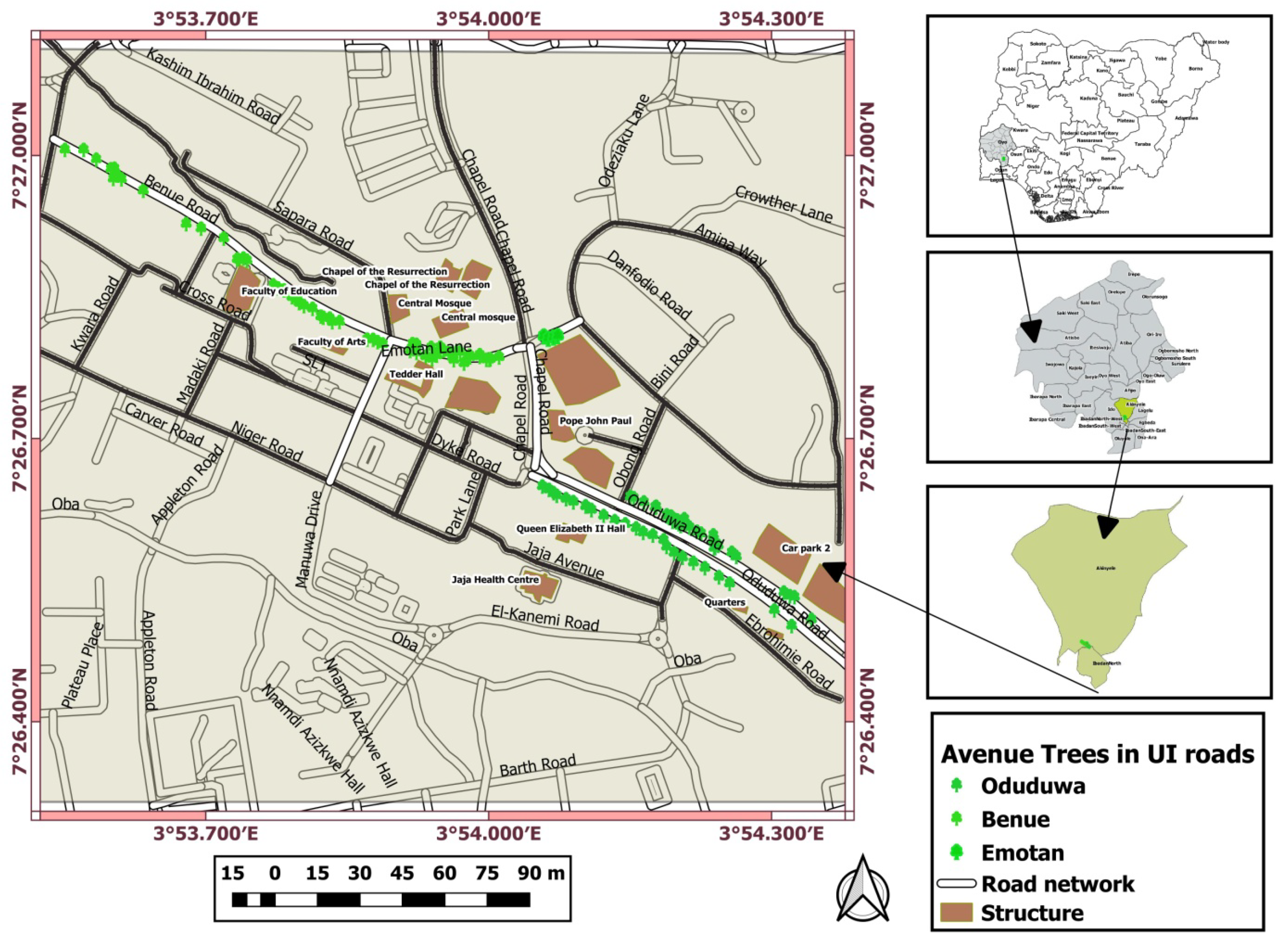
Figure 2.
Health status of avenue trees in Benue Road.
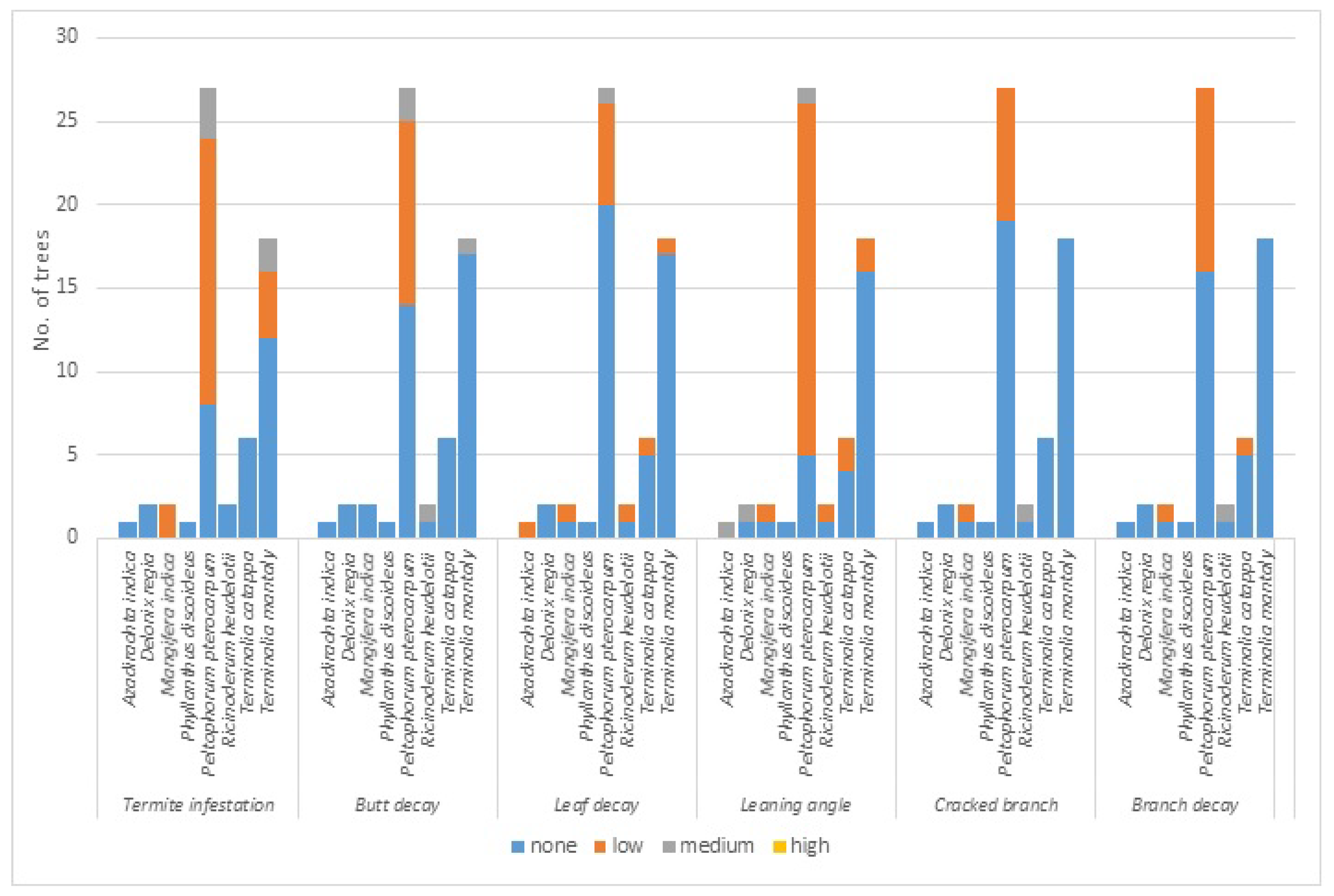
Figure 3.
Health status of avenue trees in Emotan Road.
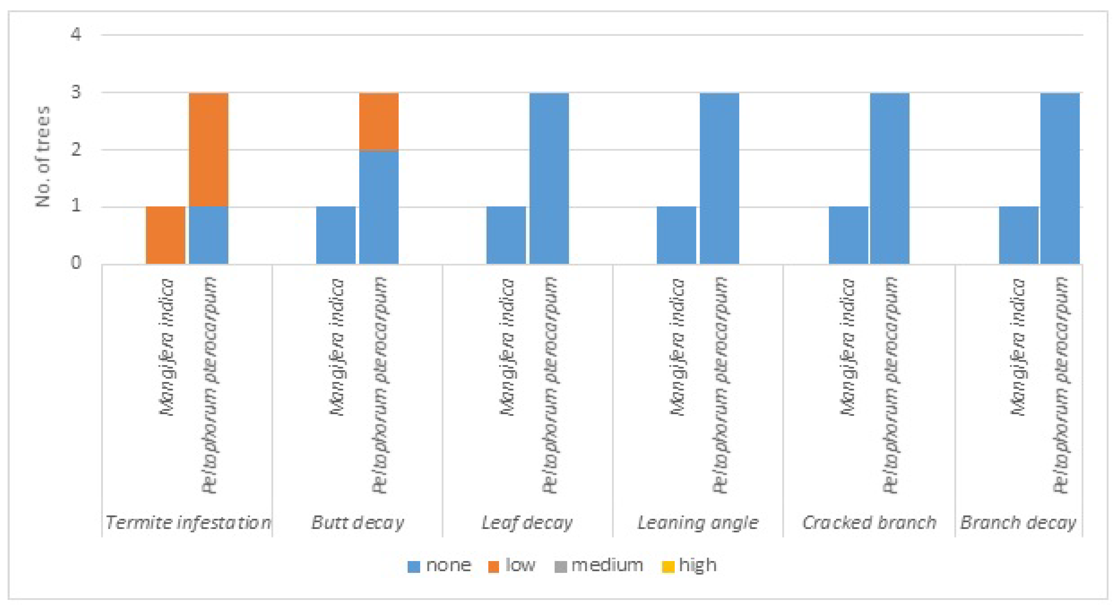
Figure 4.
Health status of avenue trees in Odudua Road.
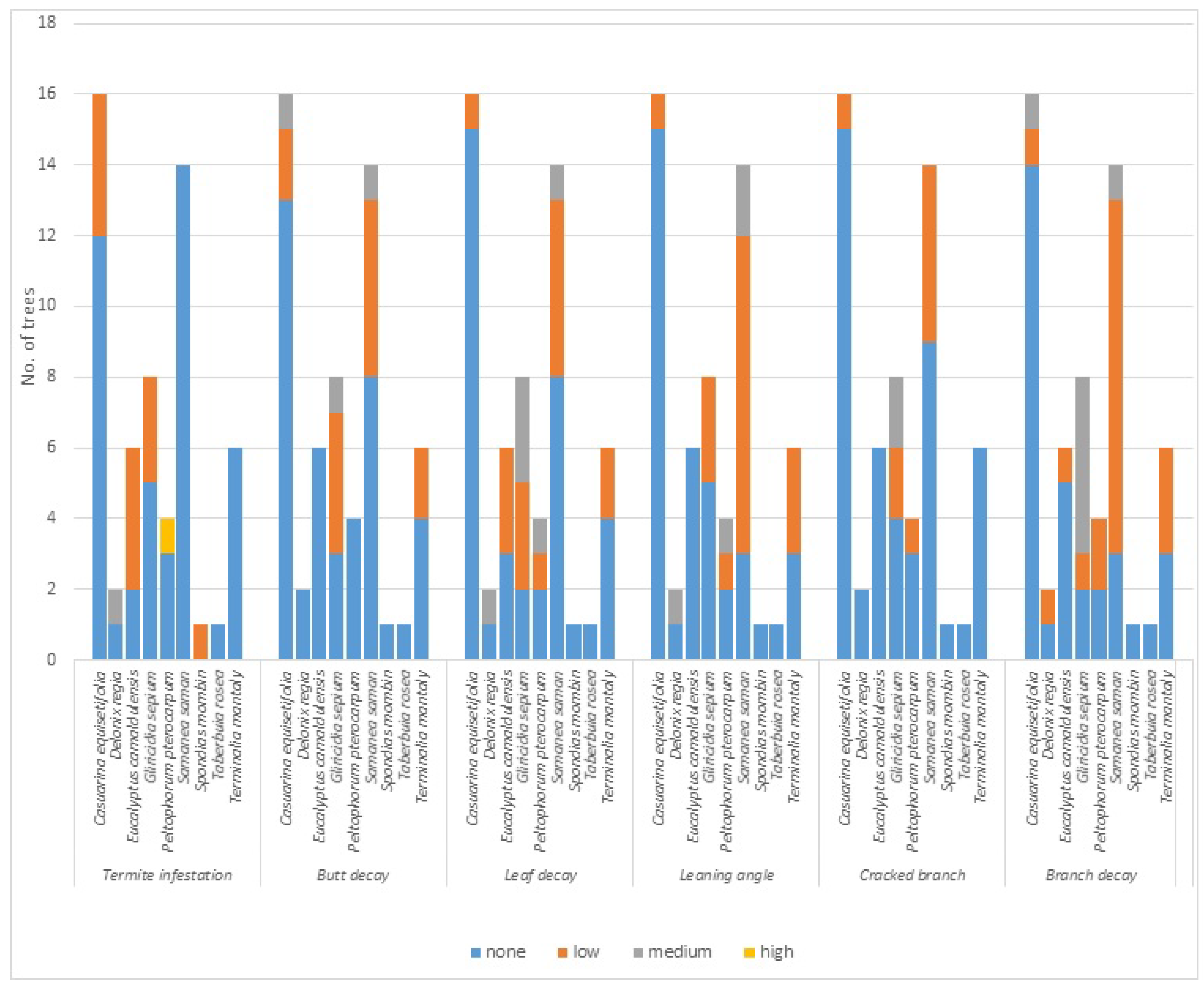
Figure 5.
Homepage of geospatial distribution and health status of avenue trees within the three selected roads of university of Ibadan.
Figure 5.
Homepage of geospatial distribution and health status of avenue trees within the three selected roads of university of Ibadan.
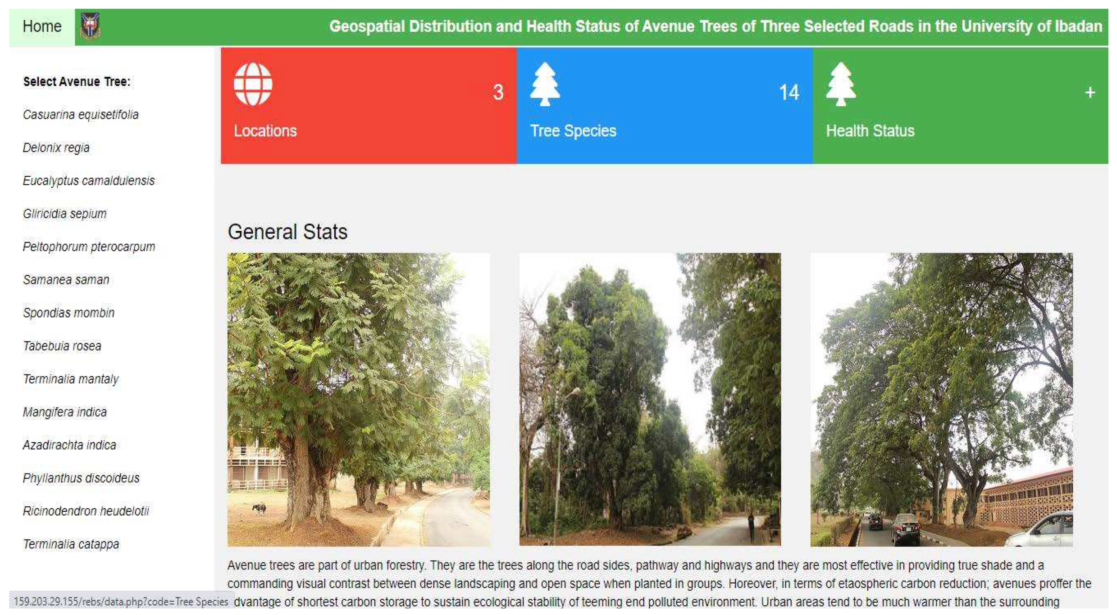
Figure 6.
Information of a specific avenue tree (Casuarina equisetifolia) on the homepage.
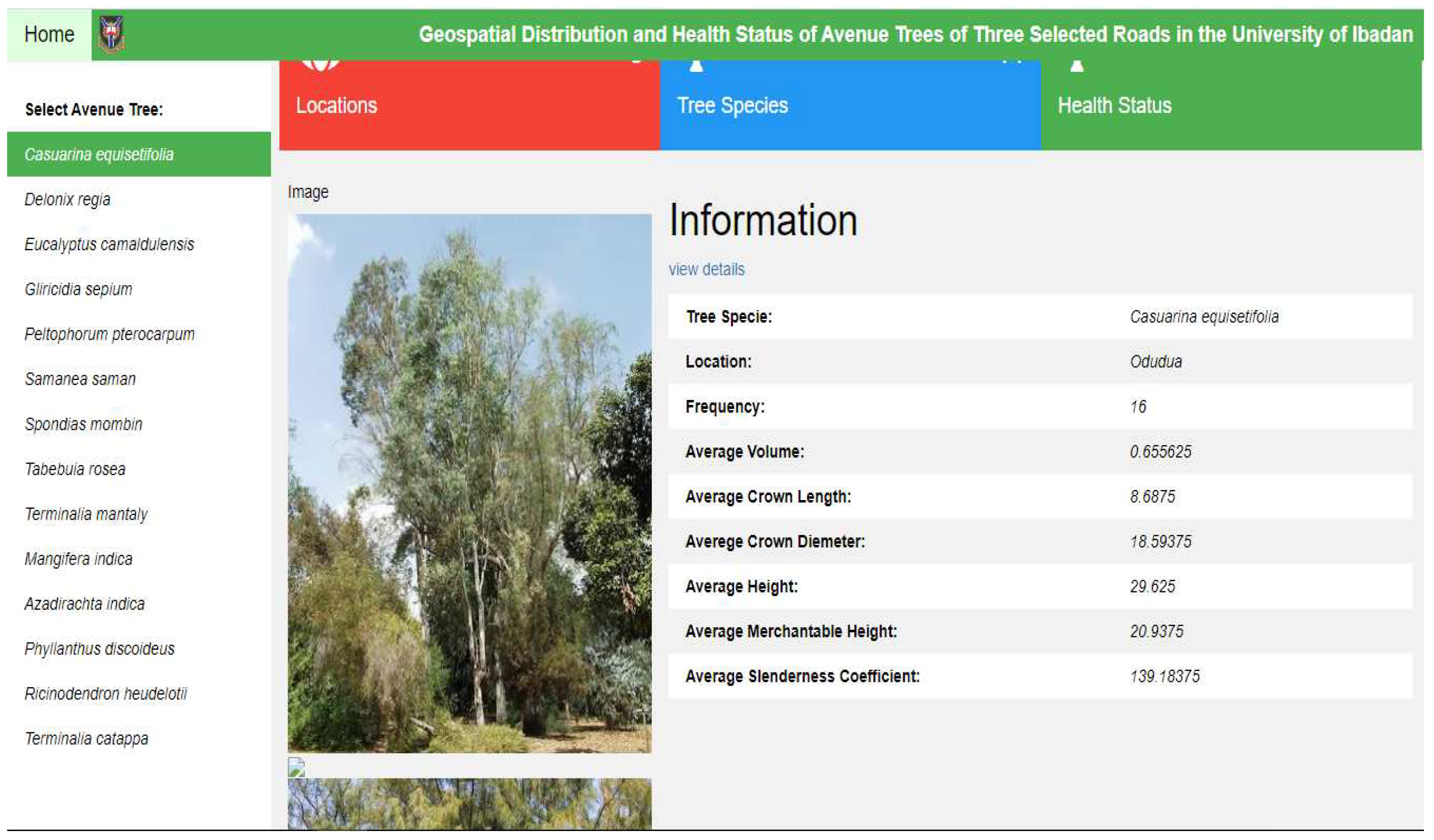
Figure 7.
The administrative page of geospatial distribution and health status of avenue trees within selected roads of University of Ibadan.
Figure 7.
The administrative page of geospatial distribution and health status of avenue trees within selected roads of University of Ibadan.
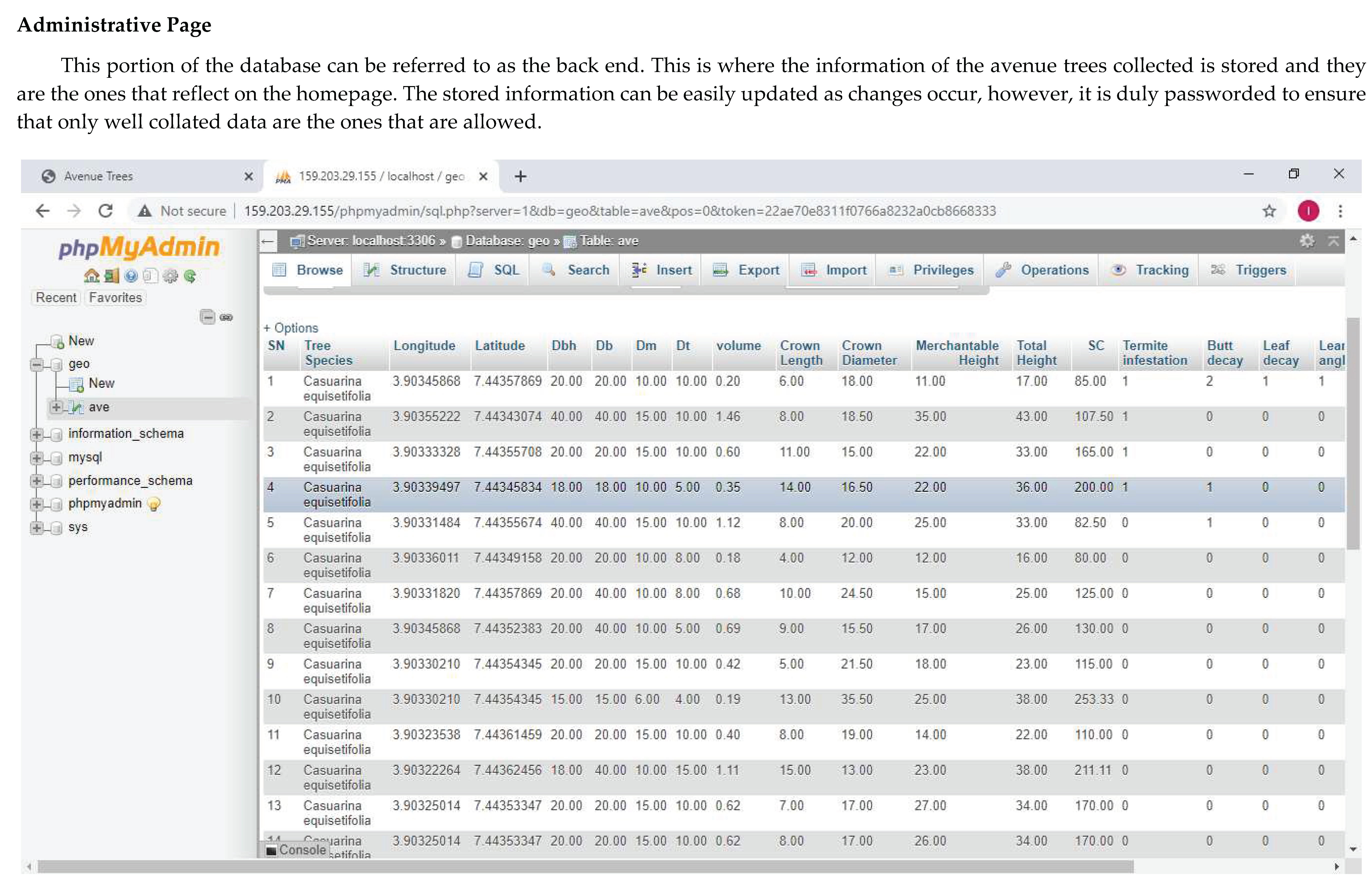

Table 1.
Overall dendrometric and structural characteristics of avenue trees in Benue, Emotan and Odudua Roads in University of Ibadan.
Table 1.
Overall dendrometric and structural characteristics of avenue trees in Benue, Emotan and Odudua Roads in University of Ibadan.
| Road | No. of species | No. of individual trees | Total Volume (m3) | Total Crown Length (m) | Total Crown Diameter (cm) | Total Height (m) | Sum of Merchantable Height (m) | |
|---|---|---|---|---|---|---|---|---|
| Benue | 8 | 59 | 42.48 | 419.60 | 793.45 | 1112.10 | 629.50 | |
| Emotan | 2 | 4 | 7.43 | 41.00 | 67.50 | 115.00 | 74.00 | |
| Odudua | 9 | 58 | 84.25 | 619.77 | 1371.55 | 1317.77 | 698.00 | |
Table 2.
Tree species and structural characteristics of avenue trees in Odudua road, University of Ibadan.
Table 2.
Tree species and structural characteristics of avenue trees in Odudua road, University of Ibadan.
| S/N | Tree species | Individual tree | Mean H (m) | Mean DBH (m) | Mean crown length (m) | Mean crown diameter (cm) | Total volume (m3) |
|---|---|---|---|---|---|---|---|
| 1 | Casuarina equisetifolia | 16 | 29.63 | 23.19 | 8.69 | 18.59 | 10.51 |
| 2 | Delonix regia | 2 | 17.00 | 30.00 | 7.50 | 37.00 | 1.23 |
| 3 | Eucalyptus camaldulensis | 6 | 18.72 | 30.00 | 9.43 | 11.75 | 4.42 |
| 4 | Gliricidia sepium | 8 | 18.44 | 28.25 | 6.74 | 28.13 | 4.59 |
| 5 | Peltophorum pterocarpum | 4 | 22.28 | 56.25 | 16.35 | 29.06 | 14.31 |
| 6 | Samanea saman | 14 | 22.19 | 52.86 | 15.19 | 28.54 | 34.08 |
| 7 | Spondias mombin | 1 | 21.00 | 20.00 | 4.00 | 47.00 | 0.38 |
| 8 | Taberbuia rosea | 1 | 17.00 | 17.00 | 5.00 | 11.50 | 0.17 |
| 9 | Terminalia mantaly | 6 | 18.70 | 51.67 | 11.37 | 21.71 | 14.56 |
Table 3.
Tree species and structural characteristics of avenue trees in Emotan road, University of Ibadan.
Table 3.
Tree species and structural characteristics of avenue trees in Emotan road, University of Ibadan.
| S/N | Tree species | Individual tree | Mean H (m) | Mean DBH (m) | Mean crown length (m) | Mean crown diameter (cm) | Total volume (m3) |
|---|---|---|---|---|---|---|---|
| 1 | Mangifera indica | 1 | 25.00 | 65.00 | 13.00 | 17.50 | 1.71 |
| 2 | Peltophorum pterocarpum | 3 | 30.00 | 48.33 | 9.33 | 16.67 | 5.72 |
Table 4.
Tree species and structural characteristics of avenue trees in Benue road, University of Ibadan.
Table 4.
Tree species and structural characteristics of avenue trees in Benue road, University of Ibadan.
| S/N | Tree species | Individual tree | Mean H (m) | Mean DBH (m) | Mean crown length (m) | Mean crown diameter (cm) | Total volume (m3) |
|---|---|---|---|---|---|---|---|
| 1 | Azadirachta indica | 1 | 30.50 | 60.00 | 16.50 | 14.50 | 2.12 |
| 2 | Delonix regia | 2 | 24.50 | 20.00 | 11.00 | 14.63 | 1.24 |
| 3 | Mangifera indica | 2 | 18.25 | 60.00 | 7.75 | 15.13 | 2.56 |
| 4 | Phyllanthus discoideus | 1 | 28.00 | 20.00 | 11.00 | 14.00 | 0.56 |
| 5 | Peltophorum pterocarpum | 27 | 19.93 | 31.22 | 7.36 | 12.20 | 22.77 |
| 6 | Ricinoderum heudelotii | 2 | 26.00 | 70.00 | 6.50 | 17.75 | 6.03 |
| 7 | Terminalia catappa | 6 | 17.58 | 23.33 | 5.58 | 11.00 | 2.77 |
| 8 | Terminalia mantaly | 18 | 15.14 | 19.17 | 6.08 | 15.26 | 4.43 |
Disclaimer/Publisher’s Note: The statements, opinions and data contained in all publications are solely those of the individual author(s) and contributor(s) and not of MDPI and/or the editor(s). MDPI and/or the editor(s) disclaim responsibility for any injury to people or property resulting from any ideas, methods, instructions or products referred to in the content. |
© 2023 by the authors. Licensee MDPI, Basel, Switzerland. This article is an open access article distributed under the terms and conditions of the Creative Commons Attribution (CC BY) license (http://creativecommons.org/licenses/by/4.0/).
Copyright: This open access article is published under a Creative Commons CC BY 4.0 license, which permit the free download, distribution, and reuse, provided that the author and preprint are cited in any reuse.


