
Submitted:
11 July 2023
Posted:
13 July 2023
You are already at the latest version
Abstract
The continuous transformations that characterise cities have placed at the centre of the political debate the theme of urban regeneration, as urban, environmental, and social rehabilitation, especially about degraded urban areas that become fertile ground for new urban functions. Considering degraded areas as the result of economic, social, physical, and environmental transition processes, their regeneration must consider an inclusive and multi-actor process involving different stakeholders and users. Such an understanding examines multiple cultural and design approaches to urban regeneration and geographical transformation. This paper implements the Geodesign approach to investigate and develop a Collaborative Decision Support System oriented to the planning and assessing wasted roadscapes regeneration. The wasted roadscapes are conceived as degraded areas located close to roads, which need sustainable strategies with particular attention to local problems related to accessibility and the inclusion of degraded areas in the planning process. Bacoli’s city (South of Italy), has been selected as a best-fit case study for testing the decision-making process elaborated, involving a working group of professors, researchers, PhD candidates, students, local authorities, and citizens. The Geodesign approach facilitated the definition of sustainable planning strategies among people with diverse backgrounds and interests, aiming at recovering degraded landscapes and connecting them to urban accessibility strategies, facing conflicts and supporting the elaboration of a shared vision.
Keywords:
Geodesign
; Collaborative Spatial Decision Support System
; Wasted Roadscapes
1. Introduction
In recent years, the contemporary city has been the subject of an investigation by architects, urban planners, sociologists, economists and anthropologists, who have attempted to focus on the themes and problems of a territorial reality that seems to be eluding new attempts at reorganisation and re-functionalisation, taking into account the challenges issued by the 2030 Agenda. The changes in the territorial organism, which have prefigured the morphology of territories over time, have led to a new awareness of a city model different from the one elaborated by modern town planning and much more attentive to environmental and social needs, a circular city model [1,2,3,4,5]. This research investigates the concept related to wastescapes [6,7,8,9], particularly the definition of wasted roadscapes and their formation in natural and urban landscapes, and the tools to evaluate and include in collaborative urban planning and regeneration processes. The theme of waste and, consequently, of reuse and regeneration are the heart of debates on the future of our world and are at the origin of research that, especially in the field of planning and evaluation, is generating new working methods and operational mindsets, with an attitude and tools that look at this condition as a value in itself.
This research investigates the importance of identifying wasted roadscapes as those places that are not evil but ready to make cities more circular. The aim is to evaluate and include them in urban planning and regeneration processes. This is a priority issue about sustainable development policies aimed at curbing the consumption of new land and thinking of the city in terms of circularity. Pluchino [10] states that the life of a city depends on the relationships it establishes with its surroundings and the network of local and global resources it feeds on. As its metabolism increases, so does its consumption, which causes a loss of agricultural land, nature reserves and consequently, ecosystem services essential to the liveability of an area, which is replaced by uncontrolled urbanisation and a persistent increase in degradation. The planning process of cities has undergone enormous changes and ecological excesses in recent times, influenced above all by cause-and-effect relationships between various social, political, economic and environmental components [11]. The anthropic exploitation of resources and land, post-industrial decommissioning and mismanagement in land governance have led to an exponential increase in the abandonment of parts of cities. In these fragile territories, functional and morphological inconsistency in the structuring of plans and projects has defined those urban voids lacking identity [12]. These characteristics of the cities’ dynamism to ongoing changes have made them increasingly adaptive, as disruptive factors and processes continuously modify non-linear systems within the system or by exogenous factors that alter or modify their original state [13,14,15]. Gilles Clément [16], in his book “Manifesto of the Third Landscape”, talks about the regeneration and reuse of spaces, urban and otherwise, that created a fragmented scenario that undermines “urban complexity and coherence” and can be revitalised through processes of evaluation and co-design that bring the inhabitants back to the centre of a synergic and collaborative network, in which services, resources and places are conceived to meet strictly local needs but at the same time reinserted into larger-scale spheres that lead to the restoration of the urban “structure”, in its unity, favouring multifunctionality and interrelationships. Indeed, the contemporary territory has complex morphological and structural configurations, many of which reflect the relationships between physical, socio-cultural and economic elements [17,18]. Moreover, recent expansion in dispersed settlements has transformed agricultural areas into a mixed and fragmented peri-urban matrix [17,18]. The resulting landscape in both pericentral districts and marginal lands is thus mixed and, at the same time, fragmented [19,20,21,22]. Such dynamics have disconnected economic functions and infrastructure networks from the urgent needs of local communities [23,24,25]. Weak interactions between various spatial parts of urban systems may reflect this structure, as each spatial context assumes a specific centrality role, thus generating a disparity between the city and the periphery [26]. Even if, then, fundamentally, both are increasingly mixed and represent a new challenge for sustainable land management [27,28,29,30,31,32,33]. Rethinking and regenerating abandoned landscapes is one of the relevant issues for territorial contexts in which weak planning systems with limited participation in policy decisions on land use management are increasingly found. The lack of spatial planning consistent with the territorial fabric results in inadequate urban planning, and this is where wasted roadscapes come into play, that is, those places (natural and otherwise) that lie close to significant infrastructure (road, railway, port area) and are now degraded because they lack function and could become an integral part of a sustainable planning process.
The research aims to develop a collaborative decision support system, implemented through the Geodesign approach [34,35,36,37,38], to evaluate wasted roadscapes within urban planning processes that aim at regeneration rather than new land consumption. Regeneration is not fully covered in planning processes, and this is a significant problem with high complexity, as it creates unsustainable planning by implying impacts on different systems (human and natural) that are constantly changing and evolving [39]. To get around this, consulting a wide range of interested parties and subject-matter experts is essential before making any final choices [40,41] and considering new sustainable planning strategies that evaluate wasted roadscapes by making them an integral part of land development. With its emphasis on collaborative and integrative planning, geo-design may help cities overcome the difficulties of coordinating crucial urban projects. By designing and implementing a collaborative design approach, geo-design is a collaborative planning method that modifies the physical environment via design. Though Geodesign has given professionals methodical and technologically sound answers to sustainability issues, new ideas of connectedness among neighbouring cities and the reclamation of landscapes [42,43,44] should be emphasised in certain regions. Integrating natural landscape systems with artificial urban systems, balancing the cultural backgrounds and visions of public and private stakeholders, and focusing on priority development strategies are all aspects of sustainability, the central theme of territorial development policies [45]. Today’s technologies and processes need close collaboration, and this is where information sharing comes in. Decision-makers dealing with novel and complicated issues, such as emergency response and public engagement, might benefit from Geodesign approaches.
This work developed a Geodesign framework [34] using different datasets and tools to integrate wasted roadscape within a geo-design process. Through a hybrid participation model (outlined not only for COVID-19 restrictions but also to involve multiple stakeholders), pre-workshop data collection days were organised.
To achieve this goal, the authors addressed the following research questions:
- How can wasted roadscapes be analysed and evaluated within a spatial regeneration decision-making process?
- How can Geodesign support decision-making in the definition of sustainable solutions?
Based on these premises, Bacoli’s city (South of Italy) has been selected as a best-fit case study for testing the urban regeneration decision-making process of wasted roadscapes.
The article is organised as follows: Section 2 describes the definition of wasted roadscapes and its evolution; Section 3 The material and method are divided into two paragraphs describing the Geodesign methodological approach for regenerating wasted roadscapes, and the case study; Section 4 discusses the results, while the discussion and closing remarks are presented in Section 5.
2. Wasted Roadscapes as an Evolutive Issue
Our daily lives and the places we inhabit and pass through are strongly defined by connecting infrastructure, traditionally perceived as monofunctional, planned by engineering logic and in many ways instrumental to extractive forms of urban change and ecological degradation. Combining infrastructures by tracing and marking landscapes generates wasted roadscapes, representing the negative repercussions throughout the territory and leading to a rupture in both the social and natural contexts. These issues are also increasingly pressing, given the significant increase in the transportation network associated with an ever-increasing anthropogenic pressure in the European territory.
Intensively used, the global constellation of roads, railways, bridges, tunnels, and ports is in a permanent state of decay and itself a producer of pollution. The territorial transformations brought about by the design of large mobility infrastructures have characterised the design of the landscape by determining spaces and places that have lost their original function over time. A multipolar landscape in which growth has been succeeded by transformation resulting in the formation of areas that are not useful to the community, lacking function and therefore subsequently abandoned. Raffestin [46] calls them landscapes “no longer alive because they are no longer real”. However, they are part of a temporal process and, therefore, can still “nurture current identity if the community makes them enter a circuit of new activities. They are forms, whose functions have changed, recoverable in the contexts of new work”. Those places that have lost their environmental, technological, cultural, and social values are called Wastescape [6] The term derived from the contribution made by the literature [47] and referred to the notion of wastelands. Wastescapes fully represent those landscapes abandoned abutting infrastructure. However, in addition to the categories identified by the REPAiR Horizon 2020 project [9], three others are proposed, associated with “Roadscapes” [48,49,50,51,52], that is, to those discarded infrastructure landscapes that take on their uniqueness given by the viewpoint of the observer.
The value of the infrastructure wasted landscape is given by regeneration objectives aimed at providing real utility and functionality to the place.
Three different types of wasted roadscapes are established:
- Social and cultural Wasted Roadscape (WRsc): represent those places that, due to their location, can assume socio-cultural value because they are located at strategic points and can be reused to define projects beneficial to society;
- Ecosystem service Wasted roadscape (WRes): are rejected places that can have intrinsic environmental value (emerged from ex-ante assessment) and can define new forms of naturalness and support the territory’s ecological aspects;
- Hub Wasted roadscape (WRhub): represent those places that, due to their morphological characteristics (emerged from analysis and evaluation before the definition of a project), assume a technical-functional value, i.e., they are those places valid for services attached to infrastructure (stations, info points, car sharing, parking lots).
Wasted roadscapes lie at the heart of the city’s complex problems and must be evaluated and analysed through various multi-criteria and non-multi-criteria approaches. They can also be included in planning processes through collaborative planning tools such as Geodesignhub (GDH) [53,54,55] and Geo-design Decision Support Environment (GDSE) [56,57] and thus become one of the elements to be included within decision support systems (Figure 1).
3. Materials and Methods
3.1. A Geodesign-Based Methodology for Regenerating Wasted Roadscapes of Bacoli
The massive urban transformations that have characterised the city of Bacoli have placed the theme of urban regeneration at the centre of the political debate, as urban, environmental and social rehabilitation, especially concerning degraded urban areas, makes them fertile ground for new functions. This meaning looks at multiple cultural and design approaches, not necessarily related to regenerative practices, but to a broader definition related to the urban process and thus to urban policy focused on decision-making aimed at the collaborative regeneration of a given context and in which the transformation of the geographic place is decided with different stakeholders. Considering degraded urban areas as the result of economic, social, physical, and environmental transition processes, it is necessary to involve local communities to rethink territorial regeneration. The local stakeholders of the municipality of Bacoli aim to focus urban development policies on the objectives expressed by the 2030 Agenda, according to which the sustainable development of territories must be inclusive and shared. Once the decision-making problem was identified, the methodology was structured considering the issues that emerged from a round table discussion with the decision maker (the Bacoli municipal authority) to the request to outline, in a spatially and temporally explicit sphere, strategies shared between the community and stakeholders, to make the territory qualitatively accessible and liveable, aiming at the regeneration of degraded contexts referred to wasted roadscapes to implement interventions related to connectivity and territorial development. In this sense, at the basis of the methodological process, it was essential to know the general issues and problems and, above all, the research questions:
- How can wasted roadscapes be analysed and evaluated within a spatial regeneration decision-making process?
- How can Geodesign support decision-making in the definition of sustainable solutions?
The construction of a collaborative planning process for defining programmatic scenarios of sustainable futures depends on the shared knowledge, analysis and evaluation of wasted roadscapes interconnected to all other systems that characterise the territory.
The methodology was structured in three phases (Figure 2):
- Knowledge and understanding (i);
- Selecting and setting (ii);
- Structuring and testing (iii)
In particular, the methodological framework identifies the Geodesign framework [58] as a suitable framework for solving the problem, linking to the operational steps, to build a decision support tool. The framework integrates the aspects of planning with those of evaluation and applies systemic thinking to decision-making problems, using a dynamic and collaborative process among stakeholders to identify sustainable planning strategies and solutions. The Geodesign framework can be identified as an iterative circular process with the possibility of reiteration in which problem-solving is decomposed into three iterative phases – forward flow, reverse flow and forward flow [58] - consisting of six models that are elaborated for all three steps by answering six specific questions. The section may be divided by subheadings. It should provide a concise and precise description of the experimental results, their interpretation, and the empirical conclusions that can be drawn.
The Geodesign framework can be identified as a process that brings together the three operational phases of knowledge and understanding (i), selecting and setting (ii), structuring and testing (iii).
The Knowledge and understanding (i) phase is identified with the framework’s first iteration - forward flow (Why) - and refers to the knowledge and understanding of the Bacoli territorial context, the problems and opportunities, and the constraints characterising the area and in particular, understanding concerns the sharing of objectives through the clarification of the decision-making problem. In this phase, the stakeholders involved in the process were also selected.
In the second, Selecting and setting phase (ii), corresponding to the second iteration - reverse flow (How) - the methods, approaches and tools helpful in conducting the study were selected. In particular, in this phase, current plans and projects were analysed, data were collected to construct the database, and criteria were set for creating assessment models for existing conditions.
The third methodological phase Structuring and testing (iii), is identified in the third iteration of the framework - forward flow (What, Where and When) and is based on the results produced in the first and second methodological phases. In this phase, the data is the driving element of the entire process system. These are organised, with the help of the appropriate computer systems, and spatially represented in a helpful format for the development of the whole project, to be shared among all members participating in the process via the GDH platform.
The operational steps of the methodological process were carried out through the involvement of various actors, identified not only from the general public but also from experts in the field and stakeholders such as lecturers, researchers and university students. Furthermore, the entire process was operationalised using spatial analysis tools in ArcGIS Pro, story-telling puppets (Geodesign Workshop Oltreporto Miseno (arcgis.com)), shared mapping (Google Mymaps) and the GDH platform that made all three methodological steps spatially explicit to support the entire collaborative decision-making process. The tools helped the collaborative process, combining different methods such as simulation models, multi-criteria spatial analysis, visualisation and data optimisation.
Furthermore, story maps facilitated getting to know the study area, while the GDH platform, with its simplified interface, allowed multiple users to provide input and generate output in real-time to support spatial decisions during the negotiation phase [59,60,61] During the elaboration of the results, the methodological steps were repeated several times, integrating information and data that emerged from meetings with the various actors involved. The outcome will describe the three stages of the methodological process in detail.
3.2. Study Area
The Municipality of Bacoli (Figure 3) near Napoli is located in a complex landscape system with a high intrinsic environmental value. It represents an ecological and landscape system of exceptional value, consisting of an inseparable interweaving of natural and anthropic structure, historical formation and agricultural land use. Over time, these four systems have determined a complex ecosystem in continuous evolution, but whose fragility appears even more exposed today after the ongoing transformations between the 1960s and 1990s. In particular, the strengthening of capitalist enterprise generated a change in urbanisation, with the construction of large industrial plants and specialised infrastructure. Since then, the Bacoli area has progressively lost its peculiar character as a real place. Urban growth has disrupted and destructured the traditional characteristic of many Phlegraean towns.
In the Bacoli area, as in neighbouring municipalities (Monte di Procida, Quarto and Pozzuoli), natural boundaries, characterised by particular geomorphological-structural features, have been overtaken and partly eroded by an exponential increase in new construction, some linked to a structured planning design, others not. These interventions have defined a new urban fabric that has seen the emergence of infrastructure connecting overland and then along the coast to link the fragmented territory. These interventions further compromised the landscape and generated places of abandonment. In particular, urban development and the phenomenon of urban sprawl first changed the morphology of the area leading over time to the phenomenon of abandonment of the urban fabric. The urban fabric of Bacoli is characterised by several settlements that have developed over the centuries around pre-existing historic cores characterised by narrow cobbled streets, low houses and ancient historic buildings, including churches, noble palaces and Roman and Greek archaeological remains. The historic centre of Baia, in particular, is home to a vast underwater archaeological area, which attracts many tourists and history enthusiasts.
Despite their environmental importance, the Phlegraean Fields’ degradation process has accelerated considerably. The imposition of environmental and archaeological constraints in connection with the provisions of the Legislative Decree resulted in the entire territory of Bacoli being declared “of considerable public interest.” However, the area’s orography and geomorphological structure have led to urban sprawl and abandonment, especially along the coast and the arterial roads at particular scenic and cultural value points. Despite being strategically located for both land and sea hubs, from an urban planning point of view, it continues to show severe infrastructural and landscape degradation, a sign of uncontrolled planning that has scarred the natural and historical landscape on the one hand and the land morphology itself on the other.
4. Outcomes
The proposed methodology identified in the Geodesign framework the steps to organise the entire process of knowledge, evaluation and selection of sustainable strategies contextualising and adapting to the relevant context conditions [62].
The sustainable development of Bacoli’s city aims to regenerate all the degraded areas that constitute the currently wasted roadscapes through their reconversion to locations serving mobility infrastructures, thereby reconnecting the town without further compromising the landscape.
4.1. Knowledge and Understanding Phase: The Data Gathering
The first methodological phase, “Knowledge and understanding (i)”, focused on knowledge of the Bacoli territorial context in its social, physical, economic and ecological aspects. Every Geodesign study presupposes an in-depth understanding of the territory under examination. For this methodology phase, many problems were encountered due to the restrictions imposed by the COVID-19 emergency, which destabilised and reshaped the approach to the case study, considering the possibility of additional data collection tools. Knowledge of territories is made more comprehensive through field trips, a condition limited by covid or otherwise limiting for those who do not live in those places and are nonetheless curious about it, which led to the search for additional tools that could quickly lead to knowledge of territory even without direct observation. In support of this phase were the municipality of Bacoli and the students of Second Level Master in “Sustainable Planning and Design of Port Areas” at the University of Naples Federico II. In particular, within the framework of the master’s course, a series of activities were organised to support knowledge of the area under examination. Current digital tools were used for both social and shared and collaborative mapping. A social media survey was structured and disseminated with a direct link to the Google Mymaps platform (urly.it/3w637) to spatialise some information for the area’s current state. This made it possible to collect many observations and data valid for knowing the territorial context. This information was then implemented through virtual inspections using the Google Earth and Street View platforms and thanks to the analysis of the main urban planning instruments in force. At a later stage, a field survey was also carried out.
The understanding of the context was based on the six questions defined within the
Geodesign framework identified to outline the six models of representation, process, evaluation, change, impact and decision [58]:
- How should the context be described?
- How is the context operating?
- Is the context working well?
- How could the context be transformed?
- What differences can the transformation cause?
- How should the context be changed?
The first question referred to the representation model. Not only were the municipal boundaries considered, but for the resolution of the decision problem, the perimeter was extended beyond the administrative boundaries to have a broader view, considering possible connections and all potential relationships. In Geodesign processes, different geographical units are related, including catchment areas, infrastructure networks, landscape networks, and historical networks. Such interrelationships and relationships between geographical and urban systems reduce the possibility of not assessing certain design risks and improving the final results. While going beyond administrative boundaries may generate potential, on the other hand, it must be said that this increases the complexity of the analysis since it must be considered that the data required for context analysis are of various kinds, with different formats and internal management systems. It is, therefore, necessary, in this sense, to understand whether there are digital databases that are also accessible on a territorial scale and that, in a certain sense, can facilitate the process.
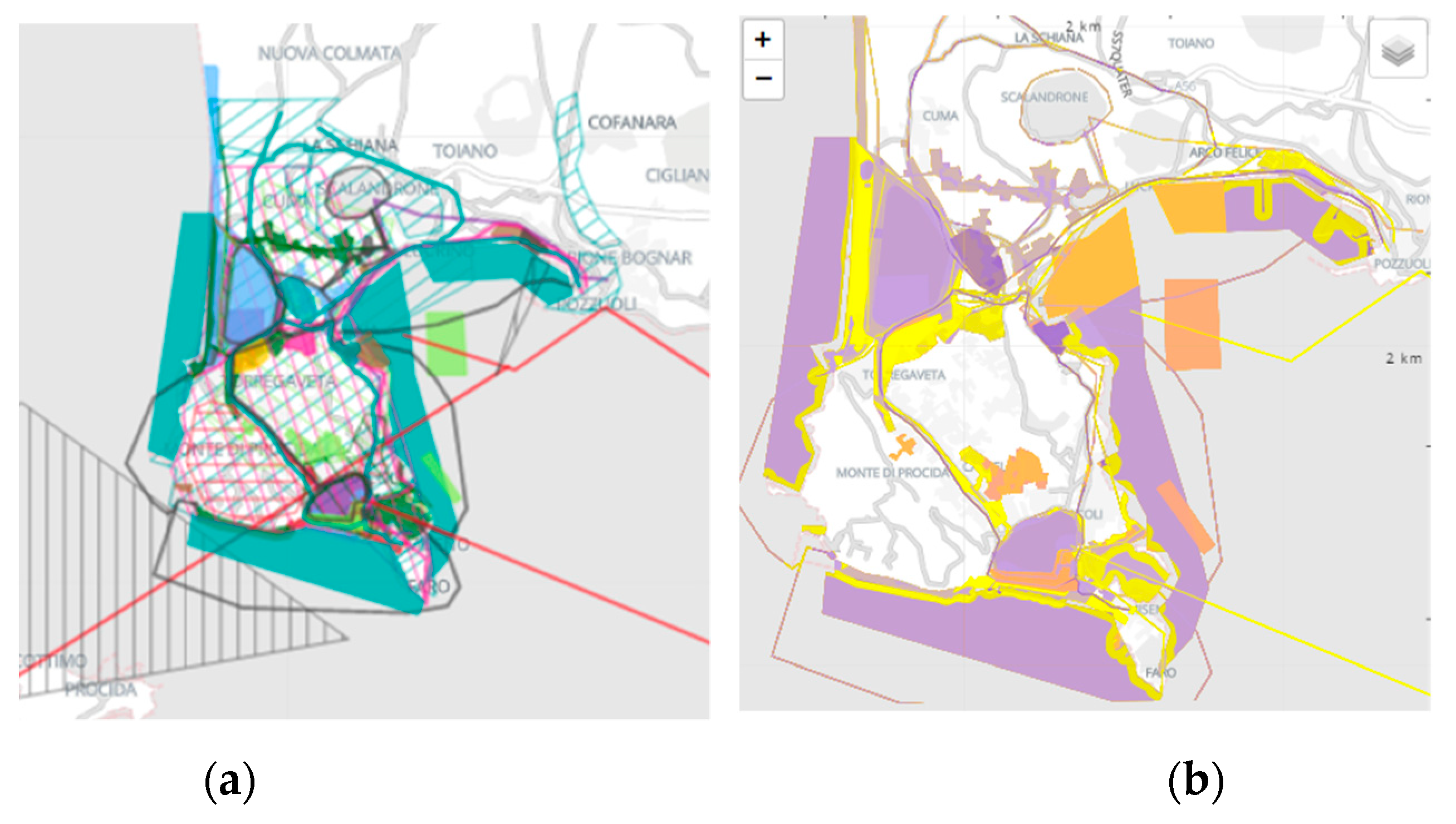
The analysis area was selected within a square measuring 850*850 metres with a surface area of approximately 7200 hectares, comprising part of Pozzuoli and Monte di Procida’s municipality. In addition, a questionnaire was structured and submitted to local communities and a broader public that frequents or knows the area under investigation for different reasons. The questionnaire and the canvas were structured on digital and collaborative platforms (suck as Miro), and a Living Lab was organised live and online (Figure 4).
The next phase referred to the evaluation model regarding the functioning of the area. In this phase, the questionnaire was submitted to communities and stakeholders via social networks and the website of the Municipality of Bacoli. The questionnaire provided information and data to a direct perception referring to the functional and non-functional aspects of the area under consideration, as they consider many social and spatial elements that help to assess the current conditions, such as the attractiveness of the site for the services offered, the presence of facilities, the presence or absence of elements of historical-cultural and landscape value, or the vulnerability relating to critical areas, in degradation or problems, affecting not only environmental but also social aspects. Following the questionnaire, a Living Lab was organised with the local communities to investigate the area’s current state, potential, and criticalities.
In addition to the data that emerged from the processing of the questionnaire and the listening table, it was fundamental to begin identifying and extrapolating from the various institutional databases the geographic information helpful in understanding the area under consideration. The data collected are referred to natural, social and economic aspects and are organised within a searchable digital database (Geodesign Workshop Oltreporto Miseno (arcgis.com). For the Change model, local communities and stakeholders involved during the Living Lab table expressed their opinions on possible future transformations through the community canvas structured in the representation model. In addition, other information was obtained from the questionnaire submitted through the leading social sites. Change can be associated with a positive or negative perception, meaning that if communities are inclined to change, this leads to a better response in proposing ideas, solutions or judgements. Questions were asked in the questionnaire, and the community canvas as to what changes the area could undergo, whether they were related to increasing land value, creating negative impacts and thus degradation, or conservation or development changes. The picture that emerged brought to attention the two main themes identified by the decision-makers as the regeneration of degraded areas and the improvement of the connective and infrastructural system. In a smaller percentage, ideas emerged concerning a change in the tourism sector, the re-functioning some coastal areas and the protection and enhancement of the area’s historical, cultural and landscape elements.
After identifying and expressing judgements and possible transformations that could change aspects that are functioning or not, they were asked to explain what kind of impacts these transformations could generate, both positive and negative. The impact model was outlined not only by referring to the canvasses and questionnaires but also and above all, by analysing and considering aspects on a legislative basis and thus defined based on technical evaluations of the area under consideration.
The knowledge phase was completed by defining the decision-making model for implementing the transformations. During this phase, general hypotheses and specific objectives were organised as different information and models emerged for the type of future change.
Specifically, the knowledge and understanding phase (i) included an initial development of future scenarios, outlining the assumptions, objectives and guiding requirements for the entire process:
- Port development;
- Connectivity with neighbouring landscapes;
- Recovery, regeneration, and reclamation of degraded and abandoned landscape linked to the infrastructure network.
In conclusion, it can be stated that in the cognitive and comprehension phase, it was possible to outline an initial overview of the reference territorial context, in which the diversified points of view defined the status quo with a greater awareness of all critical and potential aspects. The theoretical scenarios that emerged from an initial scoping phase (questionnaire and canvas) are helpful as they delineate the expectations of local communities for future urban transformation or regeneration processes.
4.2. Selecting and Setting Phase: The Data Analysis
The study methodology was defined and specified in the Selecting and Setting phase (ii), working from question six to number one. From an operational point of view, the method starts defining the decision-making model by inverting the sequence of questions. Thus, it was possible to specify the method and digital technologies to be used for the management information obtained in the knowledge phase and to define the most appropriate process of graphic restitution. During this phase, the framework models were merged two by two. The decision-making models were combined with the evaluation models based on the knowledge and cultures of different actors involved in the process.
On the other hand, the impact models were associated with the process models as they both influence the next steps. Indeed, the impact models assessed future conditions against the change models. These, in turn, were associated with representation models, as they are made up of data and consequently must have the same descriptive language with unambiguous formatting of qualitative, quantitative, graphical, spatial and temporal dimensions and criteria. The fact-finding phase brought to light relevant issues for the sustainable development of the territory related to the need to encourage the recovery and regeneration of wasted roadscapes and to improve the connective and infrastructural system both on land and sea. These are the two dominant objectives and requirements for others that emerged during the consultation phase related to the development of quality tourism, enhancement and protection of natural and historical-cultural aspects, urban mixité, reclamation of the main watercourses and bodies of water, technological and energy innovation (innovative and sustainable). These domains have successively influenced the patterns of change. It also emerged that the territory of Bacoli is an open system and interconnected with other contexts. It affects and is influenced by the other subsystems’ spatial and temporal systems. For this reason, it was necessary to specify and select the leading systems on which to focus the entire decision-making process. In particular, the systems were set by referring to the nomenclature defined by the International Geodesign Collaboration (IGC - GCGC | International Geodesign Collaboration (arcgis.com)), which provides a basic definition of eight central systems and two others functional to the context analysis under examination (Figure 5).
The eight systems presented in this way were re-discussed, with the support of C. Steinitz and M. Campagna, to outline those most appropriate to the Bacoli context. The first five systems related to “water infrastructure, agriculture, green infrastructure, energy infrastructure and transport” remained unchanged, and the “industry and commerce” system was modified and split into two systems, one of which was related to activities and functions related to commerce and the other to the tasks associated to tourism. In contrast, the “institutional and residential” systems were merged into a single category referring to urban mixité. As the tenth system, reference was made to degraded landscapes and specifically to wasted roadscapes, which represent one of the main elements put in place by the decision maker, referred to in the GHD as “reclaim”. Specifically, the ten systems identified for the Bacoli decision-making process are Water (WAT), Agriculture (AGR), Green Infrastructure (GRN), Energy (ENE), Transport (TRAN), Tourism (INDTUR), Mixed-use (MIX), Cultural heritage (CULT), Reclaim (RCLM), and Commercial (COM) (Table 1).
The ten systems were classified into “vulnerable to change” and “attractive to change”. The first category refers mainly to the resources related to that system and their availability and thus considers the WAT, AGR and GRN systems. The importance of “protection” is emphasised, as the latter are increasingly fragile and scarce. The second category, on the other hand, refers to immediate needs or those that need to be implemented (ENE, TRAN, INDTOUR, MIX, RCLM, CULT and COM Systems). Afterwards, a five-class impact matrix (Figure 6) was filled in Geodesign Hub - a scale ranging (+2;-2) from highly positive (+2:dark purple) to very negative (-2: orange) - to summarise the potential impacts (positive and negative) of the possible projects referred to ten systems. Also, the opinions and judgements of the stakeholders involved were considered for this phase. The matrix is part of the Geodesign Hub impact model. In addition, cross-system impact models dynamically modify and update the assessment models as they are developed [54] Using this impact matrix, the Geodesign Hub platform can calculate the project’s implications in real-time, displaying the number of interconnected systems [63].
The change model was determined concerning the visions of the users participating in the process so that strategies and solutions could be defined democratically. In the next stage, evaluation criteria were set concerning each system for constructing the evaluation model. The evaluation models derive from the decision-making models and influence the changing models by directing the project to areas needing changes or limiting it to other sites that need protection and preservation. The criteria and values underlying the evaluation models refer to different variables also expressed positive (attractiveness) or negative (the aggravation of situations of the vulnerability of a particular resource, place or activity) characteristics.
4.2.1. Evaluation Map
Since the evaluation models should also be understandable to a non-expert audience, it was decided to set the criteria by referring to five levels of possibility to transformations, identified through a semaphore scale:
- Dark green (Feaseble) represents the highest feasibility for change, as there are prerequisites for new projects;
- Green (Suitable) means suitability for transformation, as the area already has technologies that support the project;
- Light green (Capable) identifies cases where transformations are appropriate unless the means to support interventions are provided;
- Yellow (Not appropriate) identifies cases where changes are inappropriate;
- Red (Existing) represents areas already healthy where the system should not be compromised.
A reference database was organised and set for each system through various approaches and methods of spatial analysis in GIS and field analysis. Ten evaluation maps were produced. During this phase, greater weight was given to the system related to transportation, and that wasted roadscapes, which represent the two main elements for the resolution of the objectives made explicit earlier; the others underwent a more simplified analysis process. An overlay of multiple layers characterised the combination of the selected variables. Each layer of the variables was set according to the semiotics defined by the IGC to the five traffic light colours (dark green, green, light green, yellow and red). The dimensions and variables helpful in defining the five eligibility conditions were then selected. Some indicators were set through a kernel density, others through an urban network analysis.
Through addition and subtraction in the spatial environment, all the dark green elements were combined first, then the green-only ones, and then the light green ones. The same process was done with the yellow and red elements superimposed on the previous combinations. Overall, areas were defined where there is already functionality, where intervention is needed, and where it is best not to provide an intervention to the transportation system. The map is a qualitative compositional spatial indicator composed of multiple variables.
The reference database used to build the assessment maps consisted of information that emerged from stakeholder meetings, mapping shared online with Google Mymap (Figure 7), official sources such as ‘Urban Atlas, OSM, Corine Land Cover data from the Campania Region, the Basin Authority, the Park Authority and the municipality of Bacoli.
It was reasoned in levels starting from red and gradually combining the different groups to dark green. For only the systems “Energy and Urban Mix”, a Python script (MIT License. Copyright (c) 2019 Geodesignhub Urban-Atlas-Evaluations-Builder/LICENSE at master geodesignhub/Urban-Atlas-Evaluations-Builder GitHub) was used referred to automatic data processing on Urban Atlas and Corine Land Cover analysis basis. Restoration and upgrading current water systems and developing new “blue infrastructure” are all possible outcomes envisioned by the WAT system. Possible actions that can be envisaged for this system are interventions at lake mouths to restore and improve water exchange in the lake/sea system and to upgrade the hydraulic banks of streams and lakes. The criteria and data (Table 2) were used to construct the evaluation map.
The AGR system is concerned with fostering growth and efficiency in regional food production (Table 3). New businesses, brands, circuits, and structures geared toward a market that is not just local but also capable of attracting visitors interested in learning about the local production chain are all expected to emerge due to the system’s activities.
Landscape, environmental, coastal, and economic productivity are all areas that the GRN system focuses on conserving and developing (Table 4). Connecting places of high naturalistic value and ensuring sustainable use of the terrain and its resources, such a system promotes the development of green infrastructures on a metropolitan scale.
Tourism infrastructure and services are the focus of the INDTUR database (Table 5). In light of this, it plans to implement measures to preserve and expand the availability of cultural and natural assets, tourism attractions, and services to increase host capacity and lodging options. Possible actions that can be envisaged relate to enhancing the accommodation offer, growing services, activities and attractions for tourists, promoting ecotourism that leads to conservation and enhancement of the area, and enhancing the thermal areas. The measures being taken for the INDTOUR system ensure the long-term sustainability of the CULT, MIX and COM systems (Table 6) that aims to enhance and improve the local commercial sector and implement neighbourhood commerce while implementing services related to these activities.
By accommodating projects that aim to safeguard and enhance the existing local cultural heritage, the cultural system tends to promote interventions of restoration, securing and maintenance of abandoned places, the removal of landscape and environmental detractors with the creation of cultural corridors that also provide for the removal of architectural barriers, in addition to actions for the recovery of museum collections, architectural and archaeological and industrial archaeology (Table 7). Collaborative mapping has been instrumental in collecting additional data helpful in defining evaluation maps.
One of the most challenging goals in the fight against climate change and to lower consumer prices is sustainable energy efficiency, which the ENE system aims to achieve via legislation.
One of the most at-risk and possibly crucial to the region’s long-term prosperity is the RCLM. All existing deteriorated areas and structures must be planned for in this system, along with regeneration treatments, requalification, and recovery treatments linked to the logic of the circular economy. Possible actions may include the regeneration of degraded rural landscapes, the recovery of the biodiversity of the dune system, the regeneration of interstitial areas of road infrastructures, the recovery of polluted water, the adaptive reuse of buildings, the innovative rehabilitation of unauthorised or dilapidated buildings, and the redevelopment of industrial and military archaeological sites. Three dimensions were considered for data collection, corresponding to systems and variables (Table 8).
These were then used to define areas of possible transformation for the evaluation map (Table 9).
The TRAN system is essential to the productive operation of the Lab. Therefore, it is crucial to plan for direct interventions to build and enhance roads, hubs, and mobility routes to facilitate the movement of people and products over land and sea and to increase the accessibility of the territory by reducing traffic congestion. On the one hand, transportation networks should be free of tangles and congestion if technological difficulties are addressed. On the other hand, it’s essential to consider how these changes may affect the local ecosystem and how travellers’ requirements will be affected. Construct the transportation-related assessment map, a spatial database consisting of linear, point and polygonal elements comprised of road, rail and sea road infrastructure, parking lots, ports and recreation, and public transportation stops (Table 10). Again, areas of possible transformation were defined through the definition of the evaluation map (Table 11).
In particular, the municipal territory has a road network extending approximately 50 km that is qualitatively limited. Some so-called exodus roads date back to the bradyseism emergency 1980s, and there are only two access roads to the municipal territory. The morphological structure of the city presents a trafficking ring. The Eav operates two railway lines with three stops. The Circumflegrea line from Torregaveta to Licola is inactive except for the Torregaveta-Cuma connection during the summer. Both lines have the city of Naples as their terminal.
Ten evaluation maps (Figure 8) have supported the choice of change scenarios according to five degrees of suitability. The evaluation maps represent the landscape systems’ spatial representation of vegetation, hydrology, cultural and historical landscape resources, accessibility and transportation, commerce, tourist services, urban mix, and reclamation. The ten evaluation maps have helped evaluate the study area’s main characteristics.
4.3. Structuring and Testing: The Geodesign Workshop
In the third methodological phase, the results of the second iteration were implemented. In this phase, the final question of how local communities and stakeholders can be involved in a planning process focused on sustainable development that aims at regeneration rather than sealing new soil was answered. In this phase, it was organised the Hybrid Geodesign workshop (23-27 November 2021) (Figure 8) with the participation of thirty-five people, including academics from TUDelft, the University of Genoa, Vanvitelli University, and Federico II University, as well as public administration employees from Bacoli, private sector representatives, and stakeholders. Most of the participants had first-hand experience with the Bacoli and Campi Flegrei area, with varied professional experiences in fields like engineering, architecture, urban planning, GIS, Information Science and Technology made for a well-rounded Geodesign studio. Those unable to attend in person might watch live streams of the workshop sessions online.
In this phase, all data collected in the previous iterations were organised and fed into the GDH platform to co-evaluate and co-design sustainable development projects and policies. The representation, process and evaluation models characterised the pre-workshop phase (operationally over approximately seven months), while the change, impact and decision-making models covered the operational part of the workshop, which took place over five days, of which the first two days involved a further survey of the area and an introduction of the entire process to the participants, with an explanation and a session on testing of the GDH platform. A sandbox was prepared in which participants could begin to familiarise themselves with and explore the evaluation and co-design tools.
Then, the ten evaluation maps created by the coordination teams as a digital collective knowledge base from which to begin the design was presented. Before organising the design groups, the participants were assigned a diagram system from among the ten identified and asked to draw five project and policy diagrams, including the IGC System Innovations (https://www.igc-geodesign.org/global-systems-research) [63] and setting, in a sandbox, the type of funding (public, private, public and private, other, none), the type of geometry (linear or polygonal), the time frame relating to the start and end of the work, and the costs (in hectares or total).
Consequently, around 175 diagrams depicting individual policies or projects for each of the ten systems were gathered by the platform and shared with the participants in a matrix organised by the system (Figure 9).
Subsequently, the participants were divided into six groups of stakeholders with specific roles in the decision-making process (Table 12).
The evaluation models built in the second iteration were entered into the GDH, allowing the different teams to know each system’s past and present conditions. The usual style with five-level colour scales (dark green to dark red) made it possible to communicate needs immediately. The working groups thus composed, according to their role in the planning process, have defined their priorities by assigning each system a value from 1 (low priority) to 10 (high priority) (Figure 10). Each group was able to review erroneous diagrams, modify them or draw new ones (change model construction), as the interface of the GDH interface allows them to simultaneously view the change diagrams proposed by their group and those submitted by members of other groups. In the next step, each group was asked. Afterwards, each group was asked to select project proposals close to their interests to compose a scenario that would meet the required objectives to be presented later to the teams. This phase led to the construction of 12 designs, six (V1) in the first phase and a further six (V2) in the second phase (Figure 10).
For each phase, an assessment of the impacts (impact models) against each of the proposed scenarios, calculated about the target objectives for the area related to the various transformations designed to understand the weak points and reshape the choices by selecting those that minimise negative impacts and reduce implementation costs. The first design is rarely the right one right. In the first phase, not all possible iterations and possible adverse effects. In fact, in the second scenario, many of the design proposals have changed so much that some teams have eliminated some of the selected designs to reduce negative impacts and costs, while others implemented it as it was meagre.
Through discussion, the final step of the workshop comprised the collaborative building of a project proposal by all parties involved. With the help of a sociogram (Figure 11b), the similarities between the six stakeholder groups’ different project ideas were found. In the sociogram, each stakeholder group said how compatible they thought the scenarios proposed by the other stakeholder groups were, with answers ranging from “very negative” (xx) to “very positive” (++) (Figure 11a) [63] So, based on how likely they were to work together, the groups were put into two coalitions made up of:
- Tourism, Culture, Metropolitan Teams (TCM);
- Green, Developers, Farmers Team (GDH).
After that, the first round of negotiations began. Through mutual discussion and compromise, the two coalitions developed complementary synthesises of the design space (Figure ). The last step included communication and negotiation between the two coalitions to meld their plans into a scenario acceptable to all parties [63].
After the presentation of the two scenarios that emerged from the respective coalitions, there was a final phase in which, through dialogue and negotiation between the two teams, compatible policies and projects converged into a shared scenario envisioned by 2030. The proposed design for the city of Bacoli fully reflects the goals established in the preparatory stages. The frequency diagram (Figure 12) facilitated the comparison of the scenarios proposed by the two stakeholder groups (TCM and GDF).
It allowed similarities in design and policy to emerge with a simplified negotiation process. In particular, the scenario proposed by the TCM team (Figure 12a) identified many more solutions aimed at solving the problem of connectivity-both land and sea-and brownfield rehabilitation, giving less importance to the design and policy interventions planned for the WAT, AGR, GRN, ENE, INDTUR, MIX and COM systems. The scenario approved by the GDF team (Figure 12b), having selected a more significant number of design interventions for the WAT, AGR, GRN, INDTOUR, COM and CULT systems, devoted minimal selection interventions for the MIX, ENE and TRAN systems.
The two scenarios, therefore, turned out to be almost entirely different. However, negotiation and collaboration facilitated the construction of a design shared by all stakeholders (Figure 13a) with relative impacts (Figure 13b) that the different diagrams determine on the city. Specifically, for the final scenario in the negotiation phase, 123 diagrams were selected, of which 88 related to the identification of surfaces and 35 to linear paths. Table 13 shows the number of project and policy interventions for each system.
The results showed a strong focus on the transport system, followed immediately by the cultural and recovery systems. In particular, introducing the RCLM system within the Geodesign process led decision-makers to be informed about the possibility of envisaging regeneration actions that are connected to the other systems that make up a territory.
Figure 13.
(a) The final scenario. (b) The impact of the final scenario. Source: the authors.
Among the 13 actions identified, one can distinguish those referring to the three types of wasted roadscapes (Section 2):
- WRsc: Enhancement and recovery of the Roman theatre and baths area, redevelopment of the theatre compendium area and the former “Pirana area”;
- WRes: Regeneration of stagnant water and enhancement of the “Grotte dell’Acqua” thermal water springs. Reclamation of marine waters and hydrographic network
- WRhub: Reconversion of the former Pozzuoli shipyards and Miseno military areas. Regeneration of the former “Mericraft area.”
5. Discussion and Closing Remarks
Projects and policies related to the final design were oriented towards developing the network of connections by regenerating wasted roadscapes. In addition, several interventions were selected to develop the port areas, with the related rehabilitation, reclamation and regeneration of wasted landscapes.
The methodological approach outlined provided excellent support for analysing and assessing wasted roadscapes within the planning processes, involving local communities and stakeholders in general, managing possible conflicts arising in the consultation and planning stages and helping to build several alternative scenarios for the development of Bacoli by reaching consensus through negotiation and reducing the number of possible unacceptable projects. The attractiveness and vulnerability factors related to waste landscapes were understood through setting indicators and constructing assessment and impact models in GIS.
The potentialities and criticalities of waste landscapes were made explicit through a representation model composed of a scale of light traffic colours to simplify and make comprehension effective even for those without technical knowledge and experience. In the end, the proposed methodology made it possible to involve the local community and all stakeholders in the entire decision-making process, both in the initial phase, in the co-assessment and co-design phase and in the explanatory step of a territorial development model aimed at regenerating and reconnecting the Bacoli area. Moreover, the approach and the associated tools made it possible to make the wasted roadscapes active within a spatial analysis platform. The Bacoli Geodesign workshop aimed to map potential futures for the city, which is highly protected and compromised regarding its terrain and land-sea links.
A multi-stakeholder, interactive, and collaborative planning approach was established using Geodesign methodologies and technologies to address the complex issues plaguing the Bacoli region. The evaluation phase uncovered critical accessibility issues, and the GDH collaboration platform helped manage the selection and identification of sustainable solutions centred on revitalising blighted neighbourhoods and developing supporting infrastructure. It aided in comparing several options simultaneously and choosing the one that best satisfied territorial and social requirements while minimising trade-offs. Government officials from all levels and business leaders attended the session to promote more sustainable future planning. In addition, from an institutional standpoint, there is no clear leaning toward territorial development that seeks to rejuvenate existing land rather than devour new areas. The workshop served as a testing ground for incorporating an evaluation of the deteriorating systems that make up the present-day territory into planning procedures. Using Steinitz’s framework in a high-stakes workshop with GDH allows complicated issues to be solved quickly while increasing participants’ knowledge and facilitating consensus-building [28]. One potential obstacle is the time required to ensure design correctness. This method works best in the context of strategic planning and establishes a sound consensus foundation upon which to build plans for subsequent execution.
Nevertheless, some limitations emerged, especially after experimenting with a hybrid workshop. First, the involvement of different actors speaking different languages must be supported by multiple online collaborative tools. Tools (such as Miro, Mymaps, and teams) were used for the workshop to enable stakeholder interaction. It might be necessary to consider including in the platform the possibility of a chat room that allows the various teams to communicate or rooms that refer to collaborative tools for data collection. For the case study addressed, several days were needed to identify further diagrams involving local communities (citizens of different ages and with other knowledge). Although knowledge days were organised in the area before the workshop, these were not enough to make the process comprehensive, even though several strategic scenarios aimed at sustainability emerged. Participants may enhance their experience and online participation with the help of a single platform that can incorporate all maps and data, allowing them to sketch and design, elaborate impact analysis of design scenarios, and enable cooperation according to a hybrid approach.
Author Contributions
Conceptualization, MS; methodology, MS; software, MS and GP; validation, MS, GP and MC; formal analysis, MS and GP; investigation, MS; resources, MS; data curation, MS; writing—original draft preparation, MS; writing—review and editing, MS, GP and MC; visualisation, MS; supervision, MC; project administration, MS. All authors have read and agreed to the published version of the manuscript.
Funding
This research received no external funding.
Data Availability Statement
This research received no external funding.
Acknowledgements
The authors wish to thank very much Dr. Hrishikesh Ballal, Managing Director, Geodesign Hub Pvt. Ltd., for the use of Geodesign Hub in the courses of the Second Level Master in Sustainable Planning and Design of Port Areas of the University of Naples Federico II, within which the workshop presented in this paper was held. Furthermore, they wish to express their sincere thanks to Professor Emeritus Carl Steinitz and Prof. Michele Campagna, University of Cagliari, for their suggestions in the workshop realisation phase as well as for guiding the experimentation process of Geodesign in the municipality of Bacoli. Thanks also to the other organisers who helped support the workshop days, to all the participants and the municipality of Bacoli that hosted us during the Living Labs.
Conflicts of Interest
The authors declare no conflict of interest.
References
- Marin, J.; De Meulder, B. Interpreting Circularity. Circular City Representations Concealing Transition Drivers. Sustainability (Switzerland) 2018, 10. [Google Scholar] [CrossRef]
- Cerreta, M.; di Girasole, E.G.; Poli, G.; Regalbuto, S. Operationalising the Circular City Model for Naples’ City-Port: A Hybrid Development Strategy. Sustainability 2020, 12, 2927. [Google Scholar] [CrossRef]
- Bosone, M.; Nocca, F.; Girard, L.F. The Circular City Implementation: Cultural Heritage and Digital Technology. 2021. [CrossRef]
- Fusco Girard, L.; Nijkamp, P. Le Valutazioni per Lo Sviluppo Sostenibile Della Città e Del Territorio; FrancoAngeli, Ed.; Napoli, 1997.
- Girard, L.F.; Nocca, F. Moving towards the Circular Economy/City Model: Which Tools for Operationalising This Model? Sustainability (Switzerland) 2019, 11, 1–48. [Google Scholar] [CrossRef]
- Amenta, L.; Timmeren, A. Van Beyond Wastescapes: Towards Circular Landscapes. Addressing the Spatial Dimension of Circularity through the Regeneration of Wastescapes. Sustainability 2018, 10, 4740. [Google Scholar] [CrossRef]
- Cerreta, M., Inglese, P., Mazzarella, C. Wastescapes Sustainable Management: Enabling Contexts for Eco-Innovative Solutions. GAR 2019.
- Geldermans, B. REPAiR: REsource Management in Peri-Urban AReas: Going Beyond Urban Metabolism. TU Delft University 2019, 289. [Google Scholar]
- Russo, M.; Libera Amenta; Attademo, A.; Maria, C.; Formato, E.; Remøy, H.; Leer, J. van der; Varjú, V.; Arciniegas, G. REPAiR: D 5.1: PULLs Handbook. REPAiR - REsource Management in Peri-Urban AReas: Going Beyond Urban Metabolism; 2017.
- Pluchino, P. La Città Vivente: Introduzione al Metabolismo Urbano Circolare; Malcor D’ edizione, Ed.; 2019; ISBN 9788897909484.
- Bottero, M.; Datola, G.; Monaco, R. Fuzzy Cognitive Maps: Valutazione Dei Processi Dinamico per La Un Approccio Valutativo Di Rigenerazione Urbana. Journal valori e valutazioni 2019, 23, 77–90. [Google Scholar]
- Secchi, B. La città europea contemporanea e il suo progetto. TERRITORIO 2002. [Google Scholar]
- Batty, M. Cities as Complex Systems: Scaling, Interactions, Networks, Dynamics and Urban Morphologies. In Encyclopedia of Complexity and Systems Science; Meyers Robert A., Ed.; Springer New York, 2008 ISBN 1467-1298.
- Elmqvist, T.; Bai, X. Urban Planet: Knowledge towards Sustainable Cities; Cambridge University Press: Cambridge, 2018; ISBN 9781107196933. [Google Scholar]
- Holling, C.S. Resilience and Stability of Ecological Systems; 1973; Vol. 4.
- Gilles, C. Manifesto Del Terzo Paesaggio; F. De Pieri, Ed.; Quodlibet: Macerata, 2005. [Google Scholar]
- Schneider, A.; Woodcock, C.E. Compact, Dispersed, Fragmented, Extensive? A Comparison of Urban Growth in Twenty-Five Global Cities Using Remotely Sensed Data, Pattern Metrics and Census Information. Urban Studies 2008, 45, 659–692. [Google Scholar] [CrossRef]
- Duvernoy, I.; Zambon, I.; Sateriano, A.; Salvati, L. Pictures from the Other Side of the Fringe: Urban Growth and Peri-Urban Agriculture in a Post-Industrial City (Toulouse, France). J Rural Stud 2018, 57, 25–35. [Google Scholar] [CrossRef]
- Corona, P. Forestry Research to Support the Transition towards a Bio-Based Economy. In Proceedings of the Annals of Silvicultural Research; 2014; Vol. 38, pp. 37–38.
- Morote, Á.F.; Saurí, D.; Hernández, M. Residential Tourism, Swimming Pools, and Water Demand in the Western Mediterranean. Professional Geographer 2017, 69, 1–11. [Google Scholar] [CrossRef]
- Munafò, M.; Sallustio, L.; Salvi, S.; Marchetti, M. Recuperiamo Terreno. Convegno recuperiamo terreno 2015, 1. [Google Scholar]
- Salvati, L.; Mavrakis, A.; Serra, P.; Carlucci, M. Lost in Translation, Found in Entropy: An Exploratory Data Analysis of Latent Growth Factors in a Mediterranean City (1960–2010). Applied Geography 2015, 60, 107–119. [Google Scholar] [CrossRef]
- Krumholz, N. Roman Impressions: Contemporary City Planning and Housing in Rome. Landsc Urban Plan 1992, 22, 107–114. [Google Scholar] [CrossRef]
- Leontidou, L. The Mediterranean City in Transition: Social Change and Urban Development. The Mediterranean city in transition: social change and urban development 1990. [CrossRef]
- Tombolini, I.; Zambon, I.; Ippolito, A.; Grigoriadis, S.; Serra, P.; Salvati, L. Revisiting “Southern” Sprawl: Urban Growth, Socio-Spatial Structure and the Influence of Local Economic Contexts. Economies 2015, 3, 237–259. [Google Scholar] [CrossRef]
- Fregolent, L.; Tonin, S. Local Public Spending and Urban Sprawl: Analysis of This Relationship in the Veneto Region of Italy. J Urban Plan Dev 2016, 142, 05016001. [Google Scholar] [CrossRef]
- Alphan, H. Land-Use Change and Urbanization of Adana, Turkey. Land Degrad Dev 2003, 14, 575–586. [Google Scholar] [CrossRef]
- Biasi, R.; Colantoni, A.; Ferrara, C.; Ranalli, F.; Salvati, L. In-between Sprawl and Fires: Long-Term Forest Expansion and Settlement Dynamics at the Wildland–Urban Interface in Rome, Italy. Int. J. Sustain. Dev. World Ecol. 2015, 22, 467–475. [Google Scholar] [CrossRef]
- Catalán, B.; Saurí, D.; Serra, P. Urban Sprawl in the Mediterranean?: Patterns of Growth and Change in the Barcelona Metropolitan Region 1993–2000. Landsc Urban Plan 2008, 85, 174–184. [Google Scholar] [CrossRef]
- Cecchini, M.; Zambon, I.; Pontrandolfi, A.; Turco, R.; Colantoni, A.; Mavrakis, A.; Salvati, L. Urban Sprawl and the ‘Olive’ Landscape: Sustainable Land Management for ‘Crisis’ Cities. GeoJournal 2019, 84, 237–255. [Google Scholar] [CrossRef]
- Kairis, O.; Karavitis, C.; Kounalaki, A.; Salvati, L.; Kosmas, C. The Effect of Land Management Practices on Soil Erosion and Land Desertification in an Olive Grove. Soil Use Manag 2013, 29, 597–606. [Google Scholar] [CrossRef]
- Pili, S.; Grigoriadis, E.; Carlucci, M.; Clemente, M.; Salvati, L. Towards Sustainable Growth? A Multi-Criteria Assessment of (Changing) Urban Forms. Ecol Indic 2017, 76, 71–80. [Google Scholar] [CrossRef]
- Terzi, F.; Bolen, F. Urban Sprawl Measurement of Istanbul. Eur. Plan. Stud. 2009, 17, 1559–1570. [Google Scholar] [CrossRef]
- Steinitz, C. A Framework for Geodesign: Changing Geography by Design; esri press, redlands california: Redlands, California, 2012; Vol. 7. [Google Scholar]
- Campagna, M. Metaplanning: About Designing the Geodesign Process. Landsc Urban Plan 2016, 156, 118–128. [Google Scholar] [CrossRef]
- Campagna, M.; Di Cesare, E.A. Geodesign: Lost in Regulations (and in Practice). Smart energy in the smart cities 2016, 307–327. [Google Scholar] [CrossRef]
- Cocco, C.; Jankowski, P.; Campagna, M. An Analytic Approach to Understanding Process Dynamics in Geodesign Studies. Sustainability (Switzerland) 2019, 11, 4999. [Google Scholar] [CrossRef]
- Di Cesare EA; Cocco C; Campagna M Il Geodesign Come Metodologia per La Progettazione Collaborativa Di Scenari Di Sviluppo per l’Area Metropolitana Di Cagliari. ASITA 2016 Proceedings 2016, 333–340.
- Brown, V.A.; Harris, J.A.; Russell, J.Y. Tackling Wicked Problems: Through the Transdisciplinary Imagination2010, 1–312. [CrossRef]
- Pettit, C.J.; Hawken, S.; Ticzon, C.; Leao, S.Z.; Afrooz, A.E.; Lieske, S.N.; Canfield, T.; Ballal, H.; Steinitz, C. Breaking down the Silos through Geodesign – Envisioning Sydney’s Urban Future. Sage J. 2019, 46, 1387–1404. [Google Scholar] [CrossRef]
- Mayer, I.S.; van Bueren, E.M.; Bots, P.W.G.; van der Voort, H.; Seijdel, R. Collaborative Decisionmaking for Sustainable Urban Renewal Projects: A Simulation – Gaming Approach. 2005, 32, 403–423. [CrossRef]
- Cerreta, M.; Panaro, S.; Cannatella, D. Multidimensional Spatial Decision-Making Process: Local Shared Values in Action. Lecture Notes in Computer Science (including subseries Lecture Notes in Artificial Intelligence and Lecture Notes in Bioinformatics) 2012, 7334 LNCS, 54–70. [CrossRef]
- Cerreta, M.; De, P. Integrated Spatial Assessment (ISA): A Multi-Methodological Approach for Planning Choices. Advances in Spatial Planning 2012. [Google Scholar] [CrossRef]
- Attardi, R.; Bonifazi, A.; Torre, C.M. Evaluating Sustainability and Democracy in the Development of Industrial Port Cities: Some Italian Cases. Sustainability 2012, 4, 3042–3065. [Google Scholar] [CrossRef]
- Di Cesare EA; Cocco C; Campagna M Il Geodesign Come Metodologia per La Progettazione Collaborativa Di Scenari Di Sviluppo per l’Area Metropolitana Di Cagliari. ASITA 2016 Proceedings 2016, 333–340.
- Raffestin, C. Immagini e Identità Territoriali. Il Mondo E I Luoghi: Geografie Delle Identità E Del Cambiamento 2003, 3–11.
- Michael Hall, C. The Ecological and Environmental Significance of Urban Wastelands and Drosscapes. In Organising Waste in the City: International Perspectives on Narratives and Practices; Zapata, M.J., Hall, M., Eds.; Policy Press Scholarship, 2013; pp. 21–40 ISBN 9781447306382.
- Koolhaas, R. Junkspace. Per Un Ripensamento Radicale Dello Spazio Urbano; Quodlibet, 2006; ISBN 978-8874621125.
- Monclús, J.; Díez Medina, C. Urban Voids and ‘in-between’ Landscapes. Urban Visions: From Planning Culture to Landscape Urbanism 2018, 247–256. [CrossRef]
- Mumford, L. The Highway and the City. Archit Rec 1958, 123, 179–186. [Google Scholar]
- Shannon, K.; Smets, M. The Landscape of Contemporary Memory; NAi Publishers, 2010.
- Smets, M. Lotus International,Electa. Milano 2001, p. 23.
- Ballal, H. Collaborative Planning with Digital Design Synthesis. 2015.
- Nyerges, T.; Ballal, H.; Steinitz, C.; Canfield, T.; Roderick, M.; Ritzman, J.; Thanatemaneerat, W. Geodesign Dynamics for Sustainable Urban Watershed Development. Sustain Cities Soc 2016, 25, 13–24. [Google Scholar] [CrossRef]
- Campagna, M.; Steinitz, C.; Di Cesare, E.A.; Cocco, C.; Ballal, H.; Canfield, T. Collaboration in Planning: The Geodesign Approach. Rozwój Regionalny i Polityka Regionalna 2016, 35, 55–72. [Google Scholar]
- Arciniegas, G.; Šileryté, R.; Dąbrowski, M.; Wandl, A.; Dukai, B.; Bohnet, M.; Gutsche, J.-M. A Geodesign Decision Support Environment for Integrating Management of Resource Flows in Spatial Planning. Urban Plan 2019, 4, 32. [Google Scholar] [CrossRef]
- Cerreta, M.; Mazzarella, C.; Somma, M. Opportunities and Challenges of a Geodesign Based Platform for Waste Management in the Circular Economy Perspective; 2020; Vol. 12252 LNCS; ISBN 9783030588106.
- Steinitz, C. A Framework for Geodesign: Changing Geography by Design; ESRI Press, R.C., Ed.; 2012.
- Geertman, S.; Stillwell, J. Planning Support Systems in Practice Advances in Spatial Science. 2012, 580.
- Pelzer, P.; Arciniegas, G.; Geertman, S.; de Kroes, J. Using Maptable® to Learn about Sustainable Urban Development. Lecture Notes in Geoinformation and Cartography 2013, 0, 167–186. [Google Scholar] [CrossRef]
- Pettit, C.J.; Raymond, C.M.; Bryan, B.A.; Lewis, H. Identifying Strengths and Weaknesses of Landscape Visualisation for Effective Communication of Future Alternatives. Landsc Urban Plan 2011, 100, 231–241. [Google Scholar] [CrossRef]
- Campagna, M.; Di Cesare, E.A.; Cocco, C. Integrating Green-Infrastructures Design in Strategic Spatial Planning with Geodesign. Sustainability 2020, 12, 1820. [Google Scholar] [CrossRef]
- Somma, M.; Campagna, M.; Canfield, T.; Cerreta, M.; Poli, G.; Steinitz, C. Collaborative and Sustainable Strategies Through Geodesign: The Case Study of Bacoli. Lecture Notes in Computer Science (including subseries Lecture Notes in Artificial Intelligence and Lecture Notes in Bioinformatics) 2022, 13379 LNCS, 210–224. [CrossRef]
Figure 1.
Wasted roadscapes in urban planning. Source: the authors.
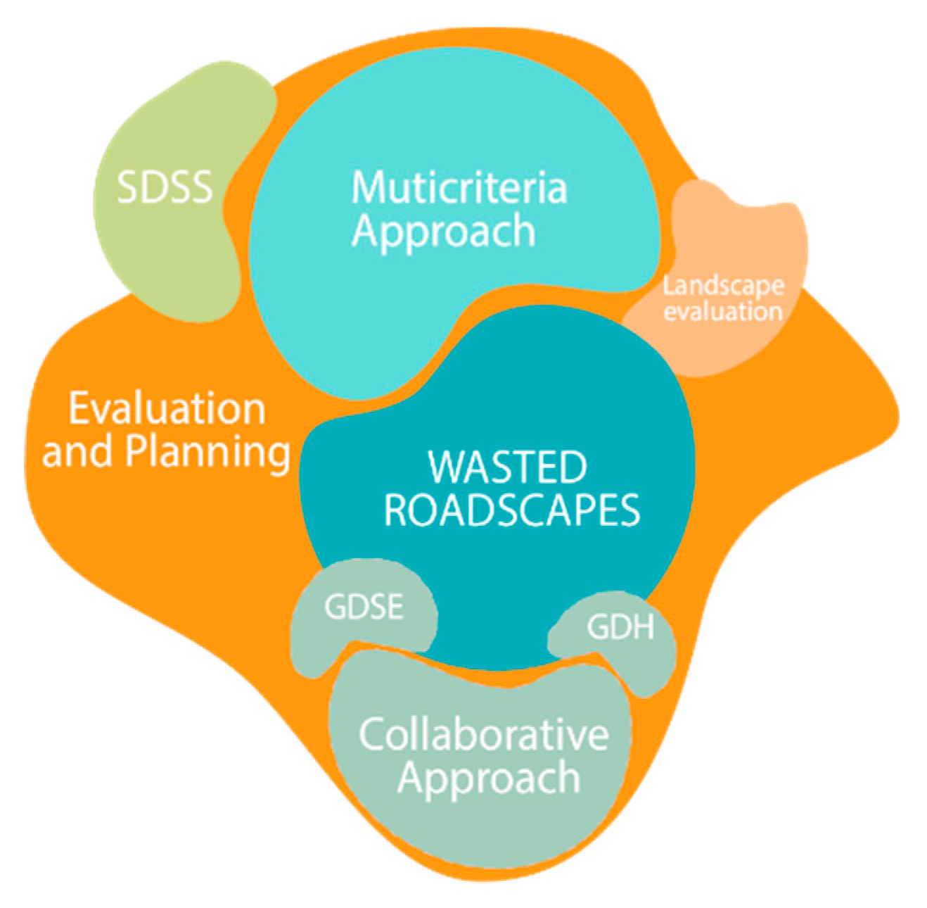
Figure 2.
Methodological framework. Source: the authors.
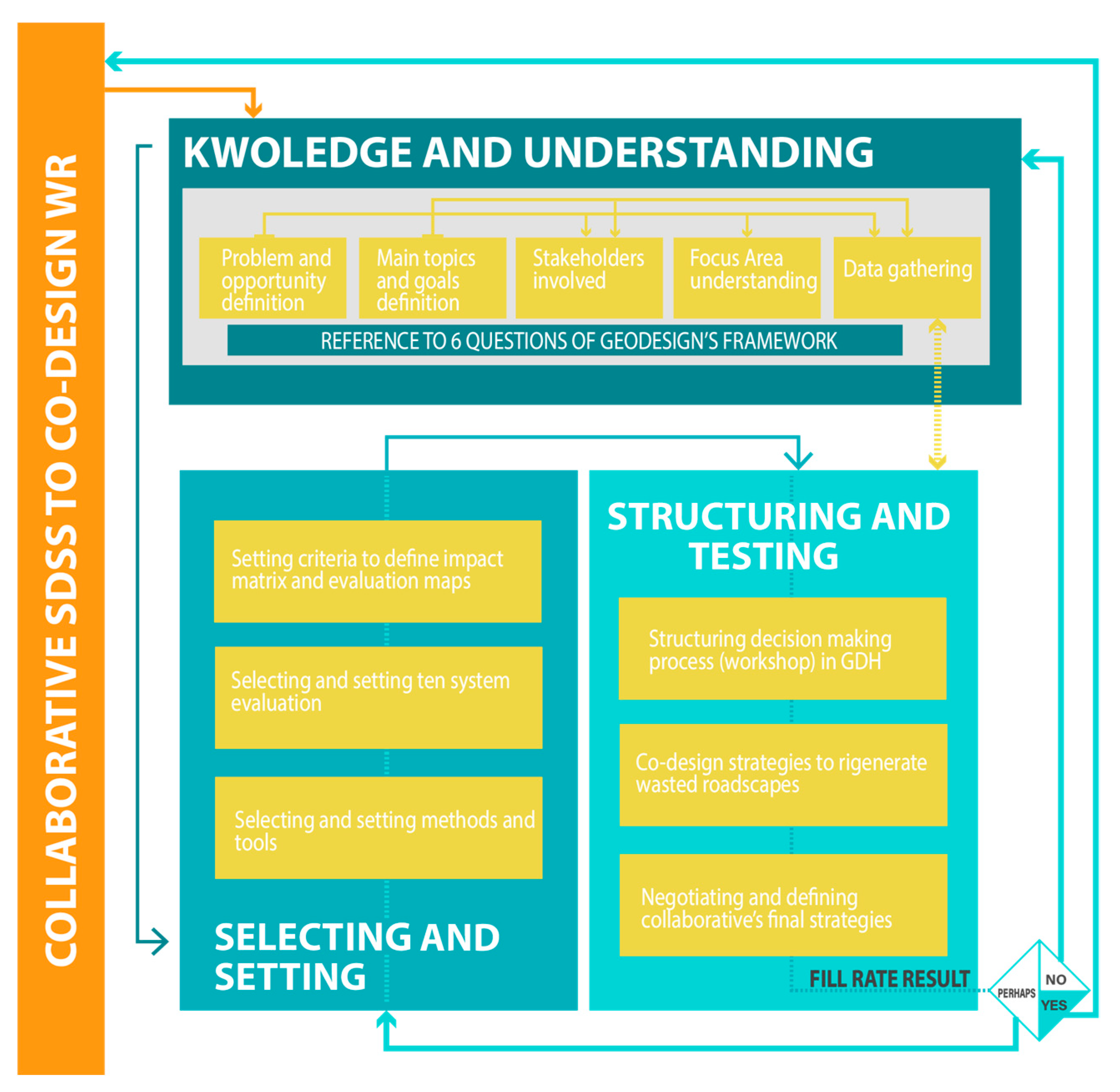
Figure 3.
The Bacoli case study. Source: elaboration of the authors
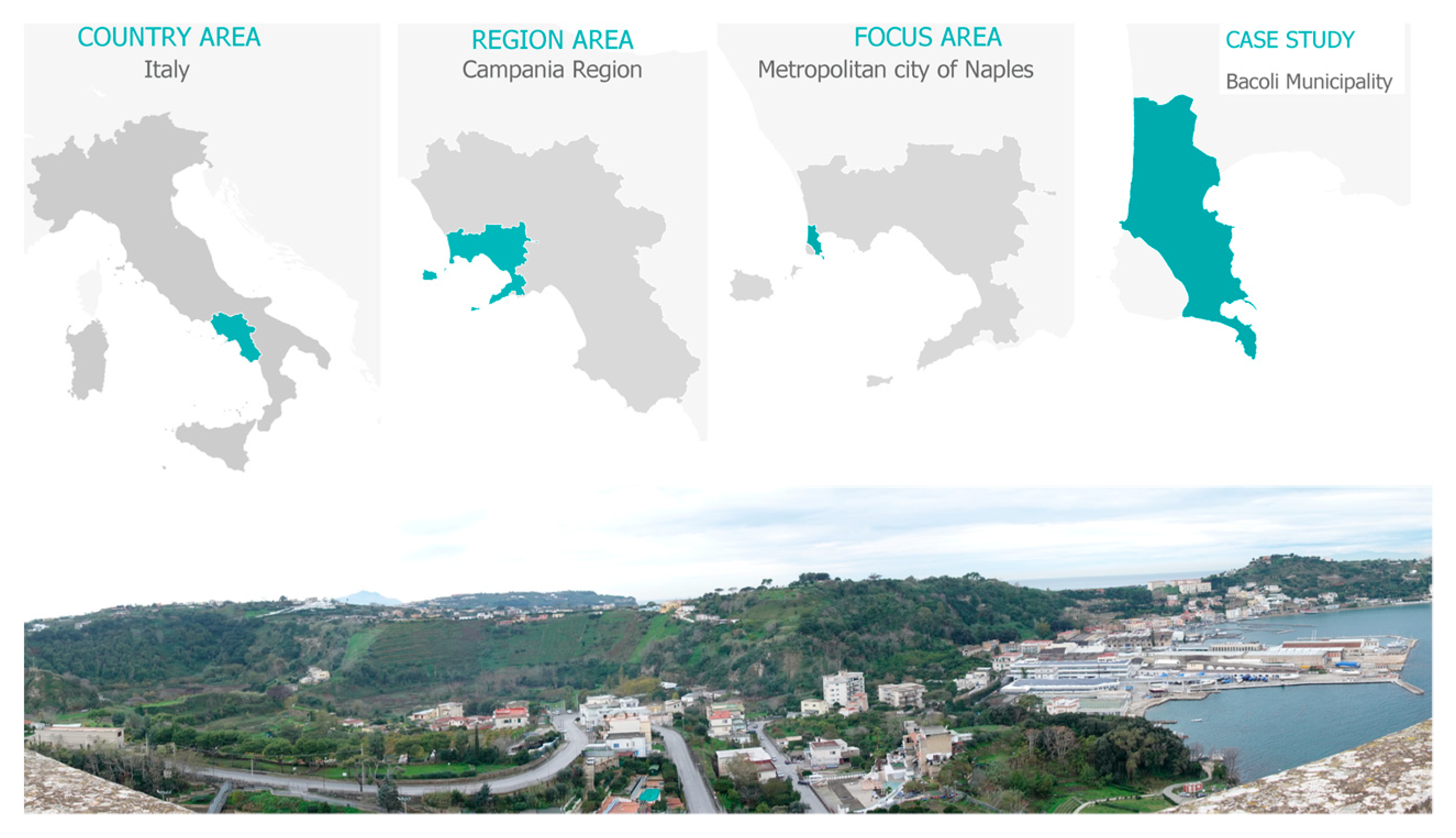
Figure 4.
(a) Living Lab for pre-workshop (b) Canva analysis. Source: photo by Chiara Mazzarella.
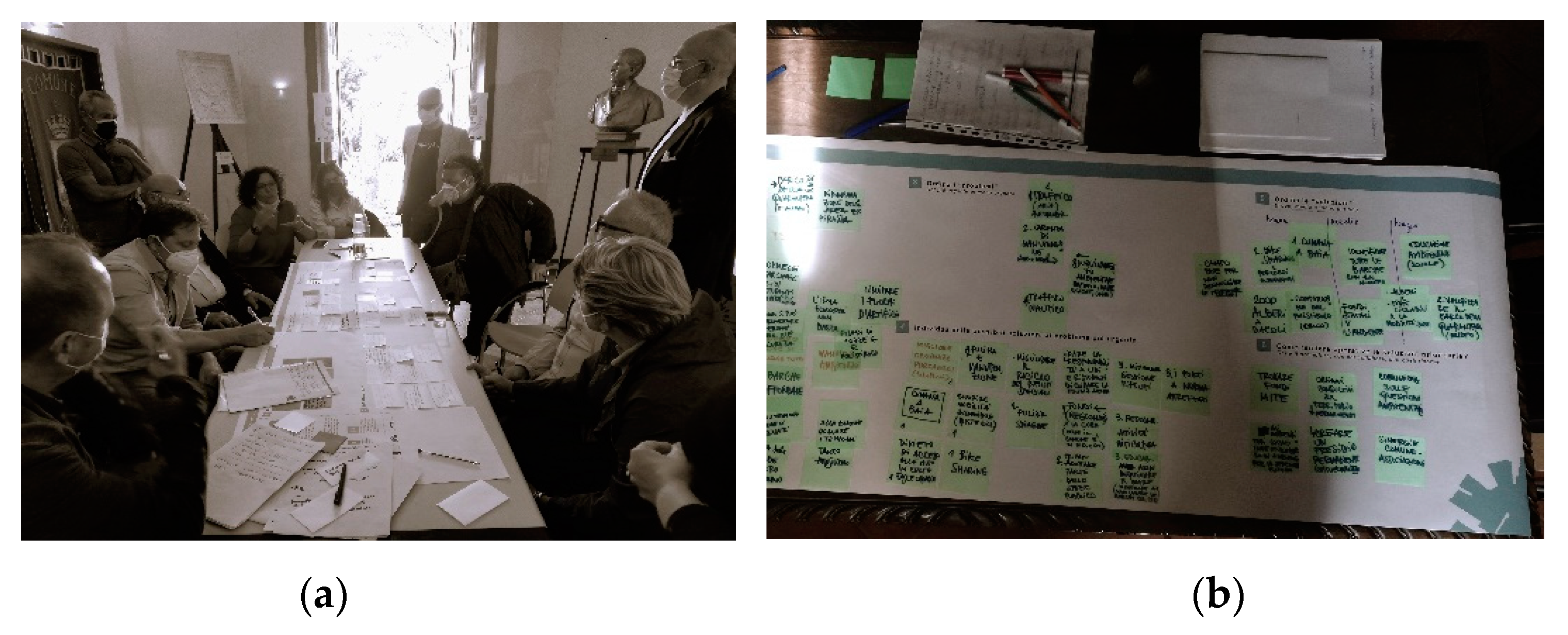
Figure 5.
Geodesign central systems. (a) Represent the eight systems identified by IGC. (b) Represent the ten systems specified for the Bacoli case study. Source: IGC for “figure a” and The Authors for “figure b”.
Figure 5.
Geodesign central systems. (a) Represent the eight systems identified by IGC. (b) Represent the ten systems specified for the Bacoli case study. Source: IGC for “figure a” and The Authors for “figure b”.
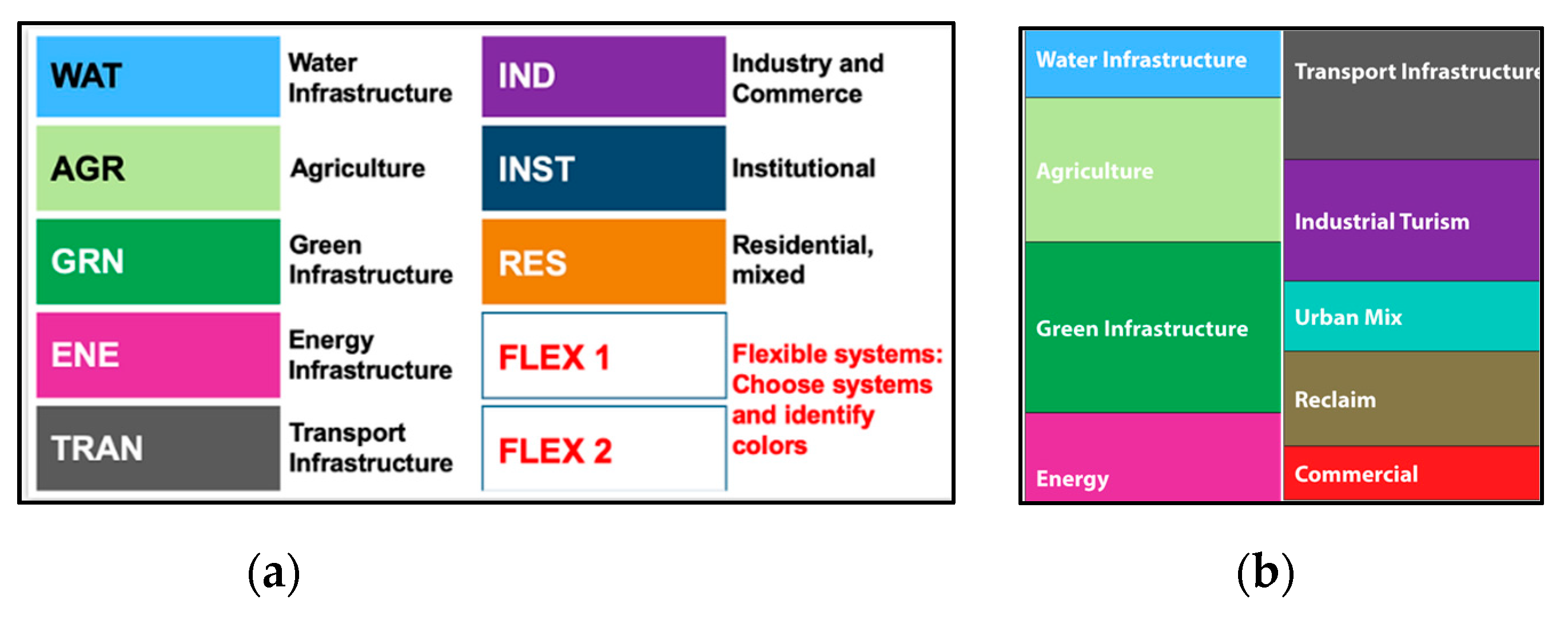
Figure 6.
The impact matrix. Source: The Authors by Somma et al. (2022) [63].
Figure 6.
The impact matrix. Source: The Authors by Somma et al. (2022) [63].
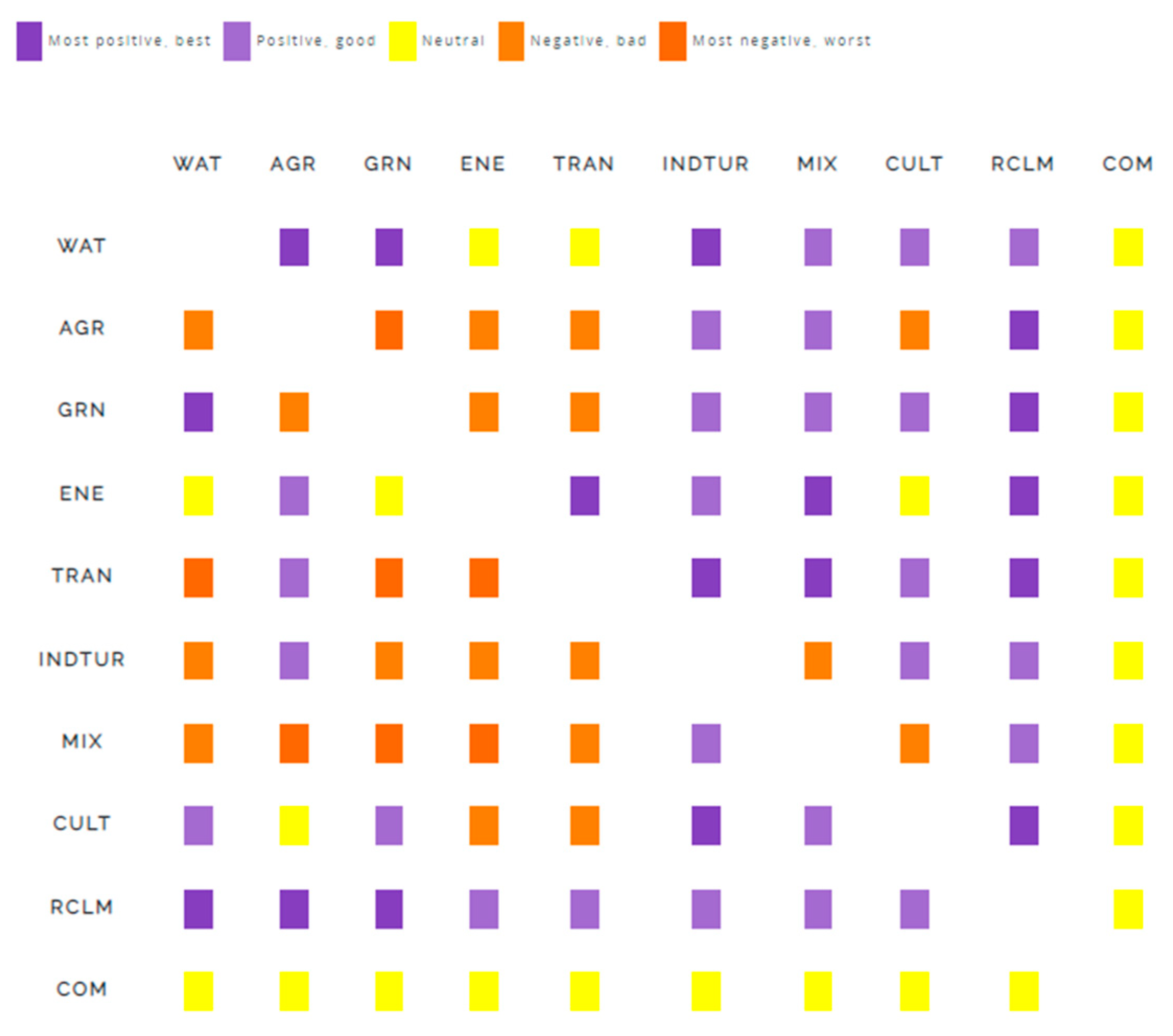
Figure 7.
Participatory mapping of Bacoli’s ten systems in Mymaps. Source: the authors.
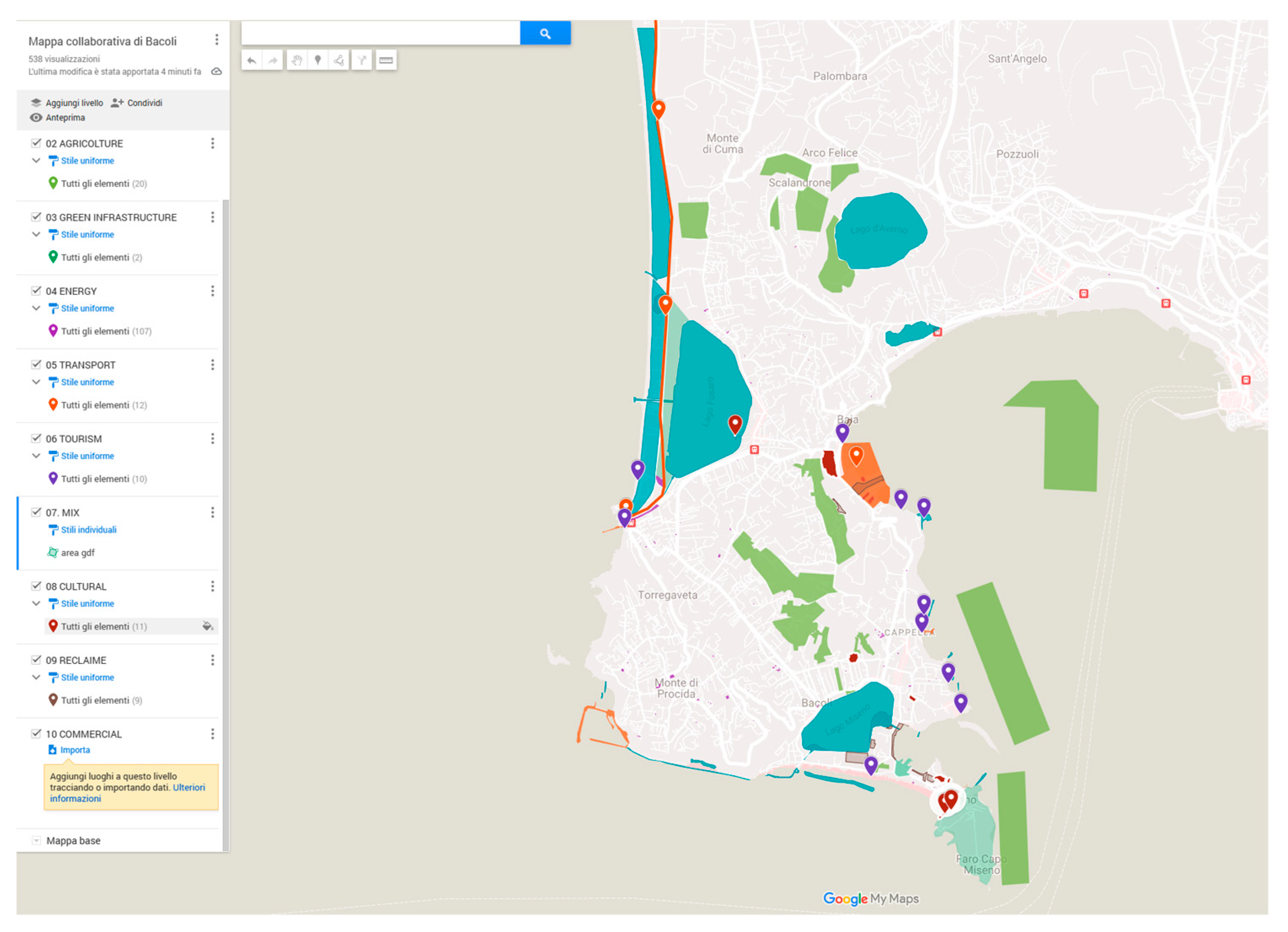
Figure 7.
Evaluation maps for the ten systems. Source: the authors.
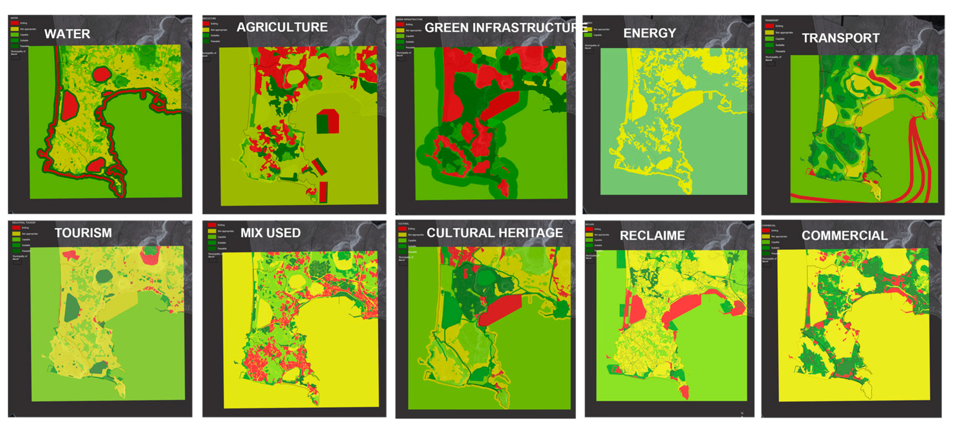
Figure 8.
The Geodesign workshop. Source: originality photos of the authors.
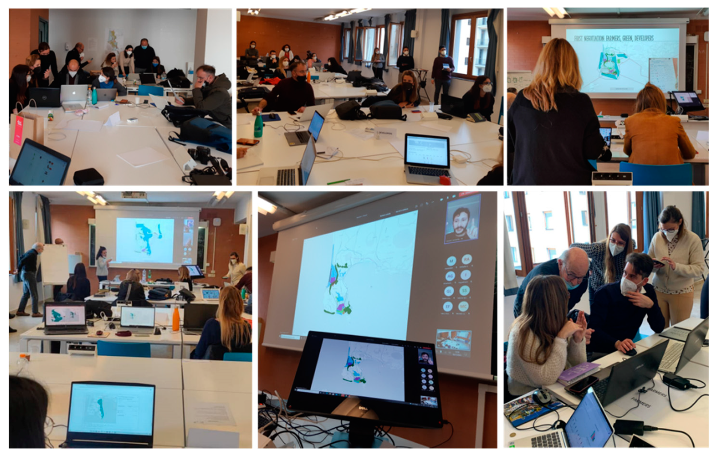
Figure 9.
Examples of policy and project diagrams. Source: the authors.
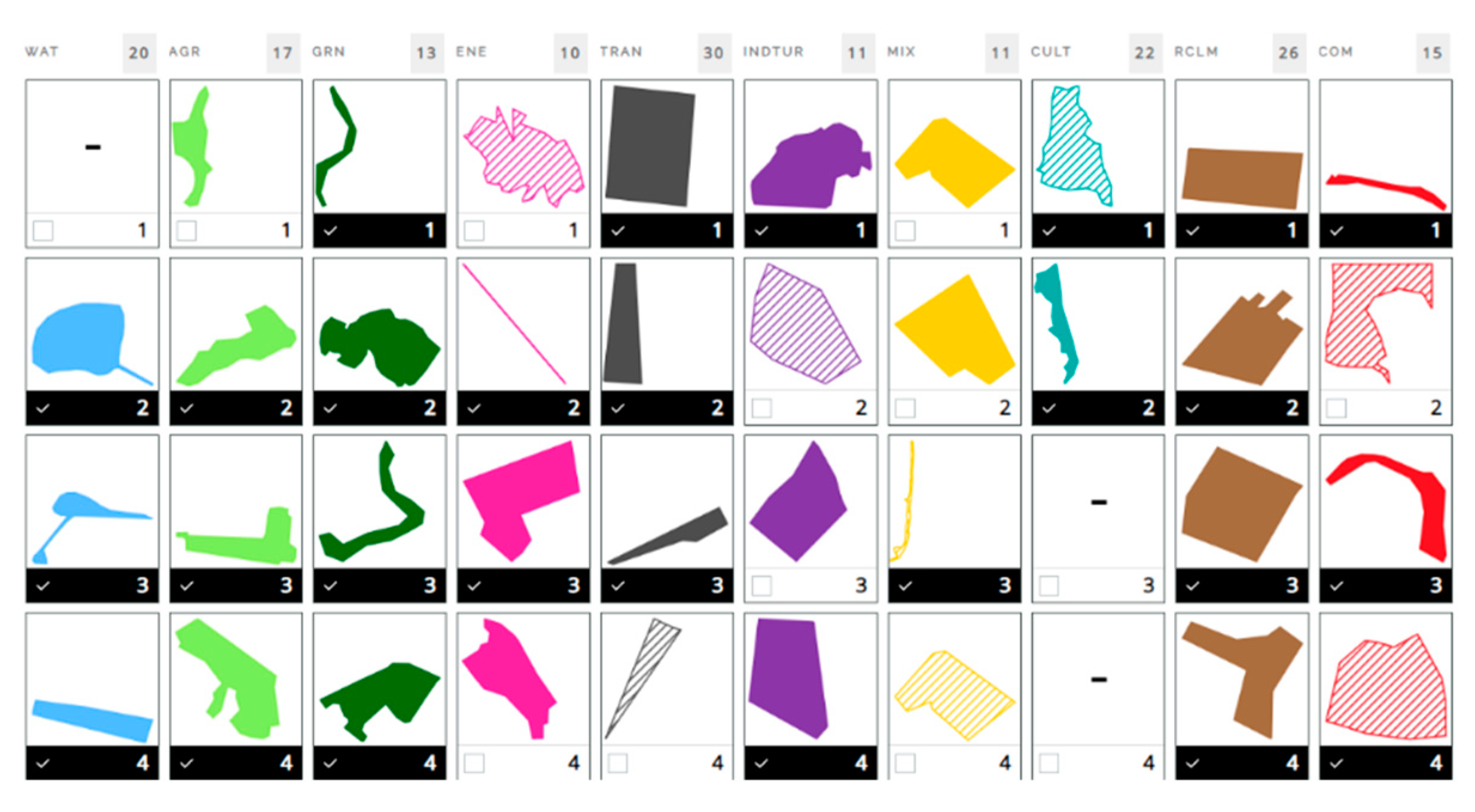
Figure 10.
The comparison design of scenarios (Version 1). Top priorities, bottom six design scenarios. Source: the authors.
Figure 10.
The comparison design of scenarios (Version 1). Top priorities, bottom six design scenarios. Source: the authors.
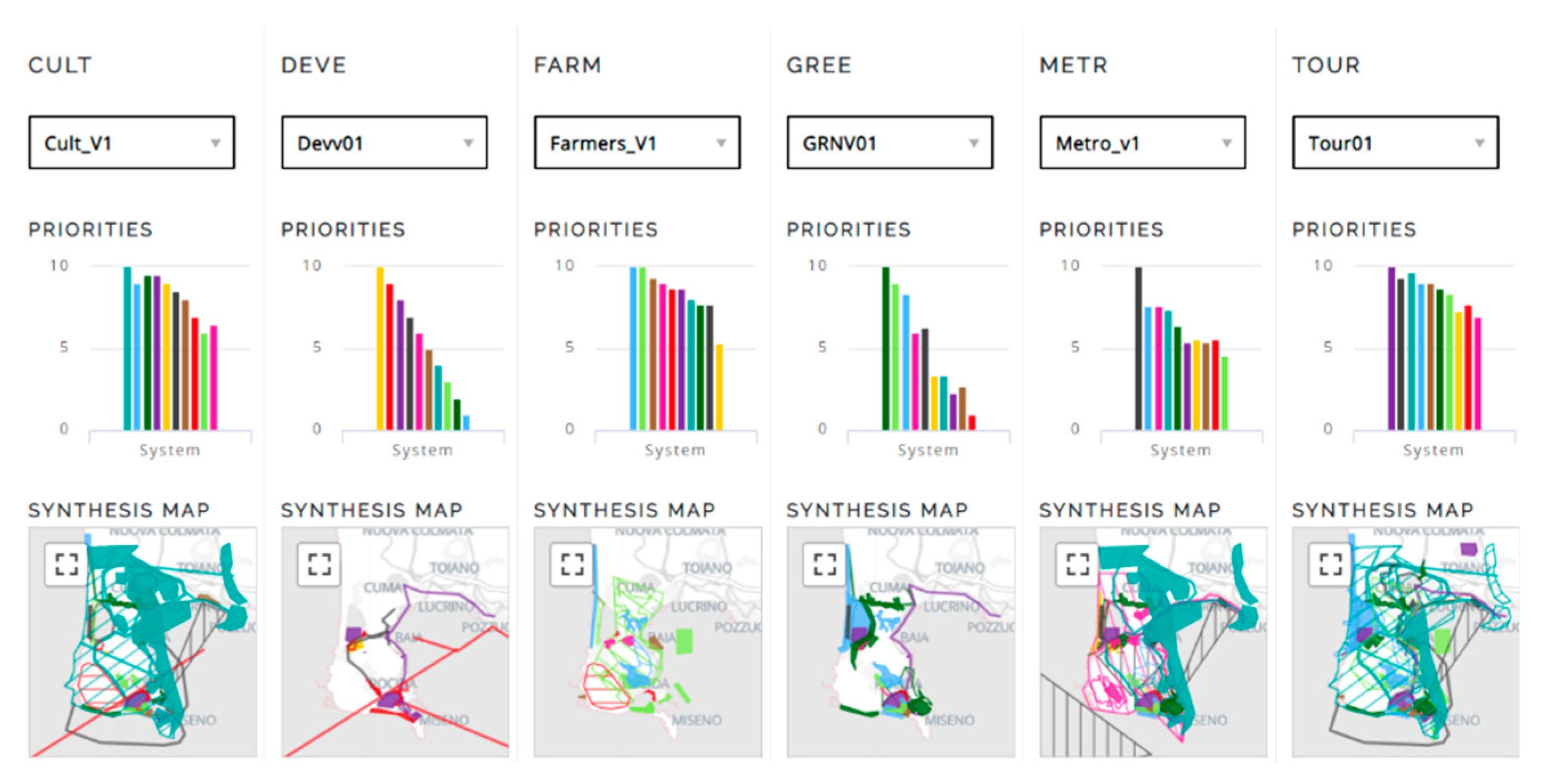
Figure 11.
(a) The decision of compatible scenario’s group by stakeholder group. (b) The sociogram for negotiation agreement. Source: original photographs by the authors.
Figure 11.
(a) The decision of compatible scenario’s group by stakeholder group. (b) The sociogram for negotiation agreement. Source: original photographs by the authors.
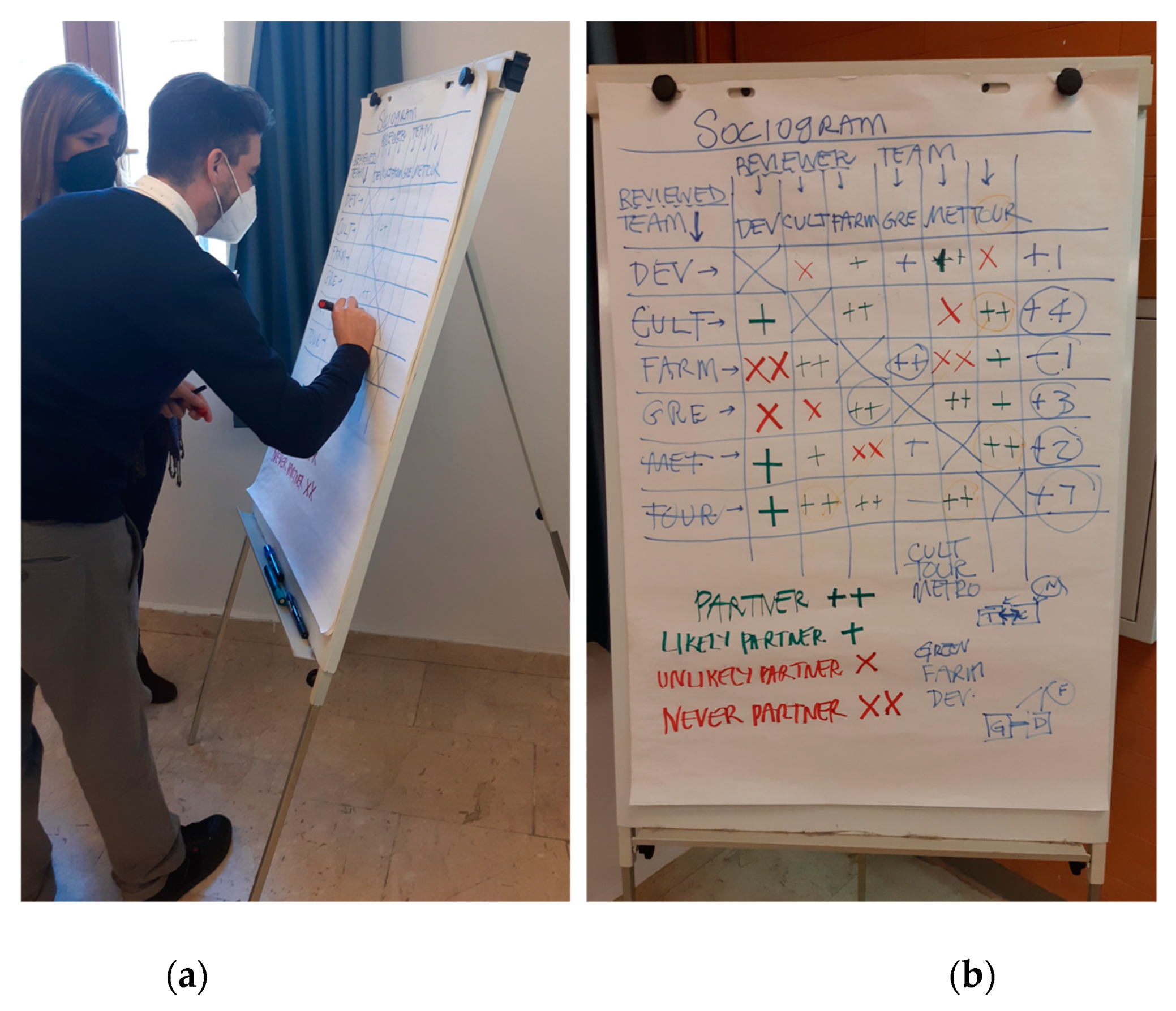
Figure 11.
The frequency diagram (a) by group TCM, (b) by GDF. Source: the authors.
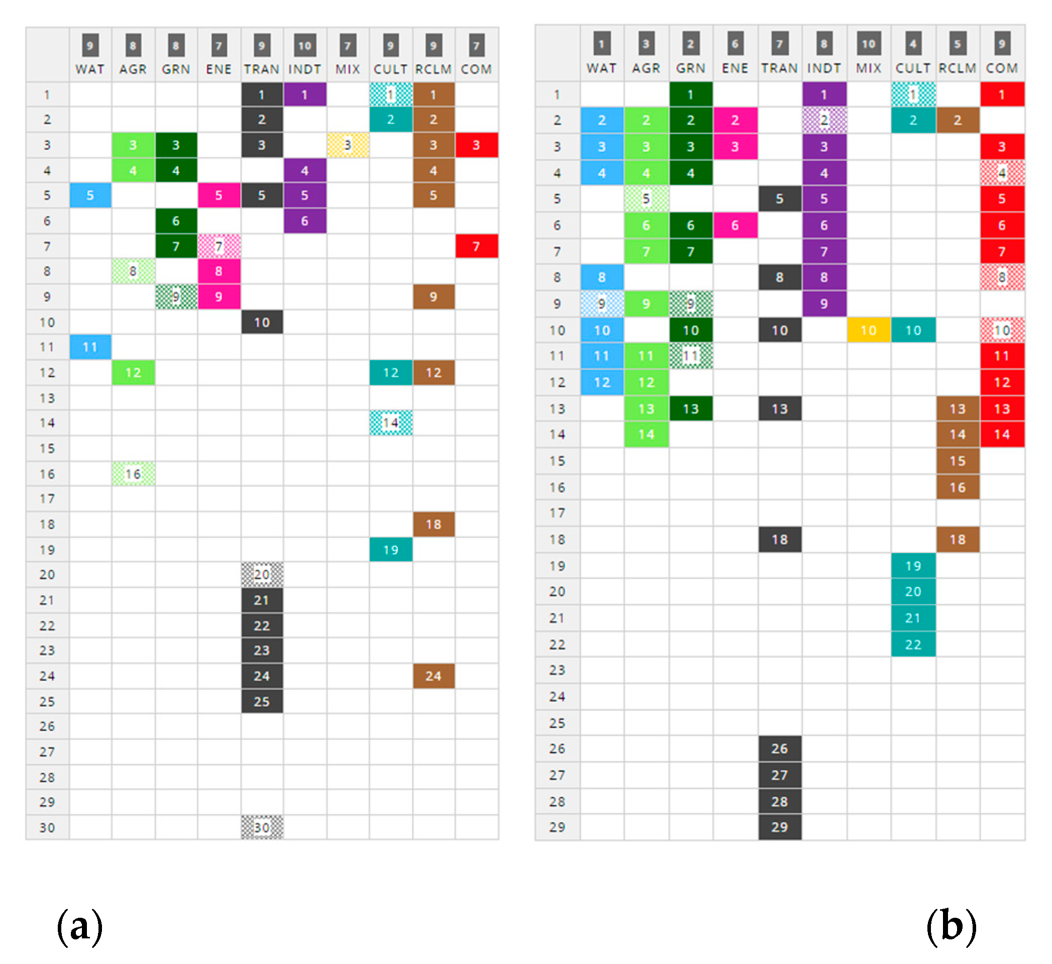
Figure 12.
(a) The decision of compatible scenario’s group by stakeholder group. (b) The sociogram for negotiation agreement. Source: original photographs by the authors.
Figure 12.
(a) The decision of compatible scenario’s group by stakeholder group. (b) The sociogram for negotiation agreement. Source: original photographs by the authors.
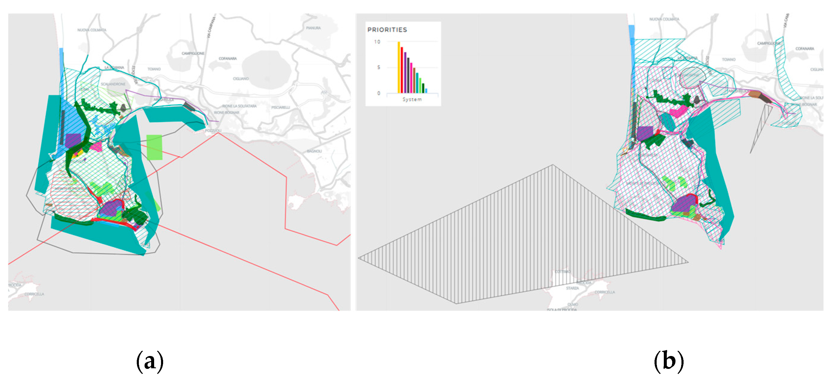

Table 1.
The analysis criteria for the identification of systems. Source: The authors’ elaboration.
| System | Acronimus | Description |
|---|---|---|
| Water Infrastructure |
WAT | It refers to the water mirror system where actions related to the restoration and improvement of existing water systems are to be envisaged existing or the creation of blue infrastructure. |
| Agriculture | AGR | It concerns the improvement and development of the local agri-food sector. The system’s actions include the creation of new enterprises, brands, circuits and structures dedicated to a local market and capable of attracting tourists through knowledge of the local production chain. |
| Green Infrastructure |
GRN | It concerns solutions for protecting and enhancing natural heritage, both in landscape and environmental aspects, in the landscape-environmental and economic-productive aspects. This system favours the creation of green infrastructures on a metropolitan scale, connecting areas of high naturalistic value and ensuring sustainable use of the territory and its resources. |
| Energy | ENE | It provides policies and strategies for sustainable energy efficiency, one of the most challenging goals to mitigate climate change’s impacts and reduce household costs. |
| Transport Infrastructure |
TRAN | It is crucial for the efficiency of the study area. Therefore, it is necessary to envisage direct interventions to create and improve the road infrastructure, nodes and mobility routes to support people and goods by land and water and make the area decongesting traffic. On the one hand, technical issues should solve the intertwining congestion problems in the case of transport systems. However, on the other hand, the impact on the surrounding environment and the needs of travellers. |
| Industrial Tourism |
INDTOUR | It refers to tourist services and assets. It provides for interventions for the protection and development of an integrated offer of cultural and environmental assets, tourist attractions and services to enhance the capacity of reception and accommodation facilities. |
| Urban Mix | MIX | The system is helpful to ensure that choices that are functional to the context provide an urban mixite that ties in with the objectives of sustainable and innovative development. |
| Reclaim | RCLM | The most vulnerable systems but the potential for the area’s sustainable development. This system must provide for the regeneration, redevelopment and recovery of all currently degraded spaces and buildings. |
| Cultural Heritage |
CULT | The system accommodates projects that concern preserving and enhancing existing local historical and cultural heritage. |
| Commercial | COM | It is the system supporting tourism and territorial development |
Table 2.
The analysis criteria for the Water infrastructure systems. Source: The authors’ elaboration.
Table 2.
The analysis criteria for the Water infrastructure systems. Source: The authors’ elaboration.
| Water Infrastructure System | ||
|---|---|---|
| Criteria | Some Data collection | Other Data |
| Feasible | UA_50000 buffer100 Protect area | Regional and municipality data: Lake system, Subsurface reticulation, Hydrographic reticulation typology, Hydraulic risk (hazard), Hydraulic risk classification, Hydraulic vulnerability, Crags, Coastal storm surge, Wetlands |
| Suitable | UA_14_100: Green urban areas; UA_14_200: Sports and leisure facilities; UA_31: Forests; UA_32: Herbaceous vegetation associations (natural grassland, moors...); UA_33: Open spaces with little or no vegetation Seawater | |
| Capable | UA_13_300: Construction sites; UA_21: Arable land (annual crops); UA_22: Permanent crops (vineyards, fruit trees, olive groves); UA_23: Pastures; UA_24: Complex and mixed cultivation; UA_25: Orchards UA_13_400: Land without current use | |
| Not Appropriate |
UA_11_100: Continuous Urban fabric (S.L. > 80%); UA_11_210/240: Discontinuous Density Urban Fabric - Industrial, commercial, public, military and private units - Fast transit roads and associated land; UA_12_220: Other roads and associated land; UA_12_230: Railways and associated land; UA_12_300: Port area | |
| Exiting | Lakes 500 mt Buffer cost zones | |
Table 3.
The analysis criteria for the Agriculture systems. Source: The authors.
| Agriculture System | |||
|---|---|---|---|
| Criteria | Some Data collection | Other Data | |
| Feasible | CUAS_42: Areas with sparse vegetation Buffer_Miticoltura: Waters adjacent to breeding facilities |
Regional and municipality data, Corine Land Cover data collection: CLC C1. Artificial surfaces; CLC C2. Agricultural surfaces; CLC C3. Wooded and seeded; CLC C4. Wetlands; CLC C5. Water bodies, Miti-culture. |
|
| Suitable | - | ||
| Capable | CUAS_31: Permanent grassland, meadows, and pastures; CUAS_32: Pastures that are unused or of uncertain use; CUAS_51: Hardwood forests CUAS_52: Coniferous forests; CUAS_53: Mixed deciduous and coniferous forests; CUAS_61: Natural pasture areas and high-altitude grasslands CUAS_62: Thickets and shrublands; CUAS_63: Areas with sclerophyllous vegetation; CUAS_73: Complex cropping and plot systems |
||
| Not Appropriate |
CUAS_71: Beaches, dunes and sands; CUAS_72: Bare rocks and outcrops; CUAS_91: Urbanised environment and artificial surfaces; CUAS_92: Waters |
||
| Exiting | CUAS_22: Orchards and minor fruits CUAS_23: Olive groves; CUAS_121: Spring-summer arable crops - grain cereals; CUAS_122: Spring-summer arable crops – vegetables; CUAS_931: Protected crops - horticultural and fruit crops; CDM_Miticoltura: Watersheds occupied by livestock facilities | ||
Table 4.
The analysis criteria for the Green Infrastructure systems. Source: The authors.
| Green Infrastructure System | ||
|---|---|---|
| Criteria | Some Data collection | Other Data |
| Feasible | CUAS_42: Areas with sparse vegetation BUFFER_CDM_ MITICOLTURA: Waters adjacent to breeding facilities |
Regional and municipality data: Natural Resources, Parks, Landslide Risk, and Faults. |
| Suitable | CLC_243: Land principally occupied by agriculture, with significant areas of natural vegetation; CLC_321: Natural grasslands | |
| Capable | Fruit trees and berry plantations; complex cultivation patterns | |
| Not Appropriate |
CLC_111: Continuous urban fabric; CLC_112: Discontinuous urban fabric; CLC_121: Industrial or commercial units; CLC_123: Port areas | |
| Exiting | CLC_142: Sport and leisure facilities; CLC_311: Broad-leaved forest; CLC_323: Sclerophyllous vegetation; CLC_324: Transitional woodland-shrub; CLC_331: Beaches, dunes, sands; CLC_512: Water bodies; CLC_523: Sea and ocean; Natura 2000 ZSC/ZPS | |
Table 5.
The analysis criteria for the Industrial Tourism systems. Source: The authors.
| Industrial Tourism System | ||
|---|---|---|
| Criteria | Data collection | Other Data |
| Feasible | Port areas Water 50 mt buffer UA50000 | Regional, municipality data and participatory mapping: Tourist spots, Minor accommodations, Beaches, Parks; Submerged |
| Suitable | Areas with activities and attractions for tourists; Green urban areas (park, seafront); Sports and leisure facilities | |
| Capable | Accommodation facilities with rate < 8; Discontinuos very low-density urban fabric (S.L.: < 10 %); Discontinuous low-density urban fabric (S.L.: 10 % - 30 %); Submerged Park of Baia | |
| Not Appropriate |
UA11100: Continuos urban fabric (S.L.> 80%); UA11210: Discontinuous dense urban fabric (S.L.: 50 % - 80 %); UA11220: Discontinuous medium density urban fabric (S.L.: 30 % - 50 %); UA11300: Isolated structures; UA12100: Industrial, commercial, public, military and private units; UA12210: Fast transit roads and associated land; UA12220: Other roads and associated land; UA12230: Railways and associated land; UA13300: Construction sites; UA13400: Land without current use Arable land (annual crops); UA22000: Permanent crops (vineyards, fruit trees, olive groves); UA23000: Pastures; UA31000: Forests; UA32000: Herbaceous vegetation associations (natural grassland, moors); UA33000: Open spaces with little or no vegetation | |
| Exiting | Accommodation facilities with rate > o = 8 | |
Table 6.
The analysis criteria for the Commercial systems. Source: The authors.
| Commercial System | ||
|---|---|---|
| Criteria | Data collection | Other Data |
| Feasible | Dense Urban Fabric (S.L.: 50% - 80%) | Regional, municipality data and participatory mapping: Marco industrial/commercial areas; other commercial activities |
| Suitable | Discontinuous medium-density urban fabric (S.L.: 30% - 50%) | |
| Capable | Discontinuous low-density urban fabric (S.L.: 10% - 30%); Open spaces with little or no vegetation; Herbaceous vegetation associations (natural grassland, moors...); Land without current use | |
| Not Appropriate |
Natural park Archeological sites Water sea, rivers and lakes Coast and dunes | |
| Exiting | Bars; Cosmetics shops; Agribusiness; Car washes; Neighbourhood markets; Restaurants; Sports shops; Supermarkets; Toy shops; Industrial activities | |
Table 7.
The analysis criteria for the Cultural Heritage systems. Source: The authors.
| Cultural Heritage System | ||
|---|---|---|
| Criteria | Data collection | Other Data |
| Feaseble | buffer 500 mt ZSC/ZPS Sea water | Regional and municipality data: Lake system, Subsurface reticulation, Hydrographic reticulation typology, Hydraulic risk (hazard), Hydraulic risk classification, Hydraulic vulnerability, Crags, Coastal storm surge, Wetlands |
| Suitable | CLC_243: Land principally occupied by agriculture, with significant areas of natural vegetation CLC_321: Natural grasslands |
|
| Capable | Fruit trees and berry plantations Complex cultivation patterns | |
| Not Appropriate |
CLC_111: Continuous urban fabric; CLC_112: Discontinous urban fabric CLC_121: Industrial or commercial units CLC_123: Port areas |
|
| Exiting | CLC_142: Sport and leisure facilities; CLC_311: Broad-leaved forest CLC_323: Sclerophyllous vegetation CLC_324: Transitional woodland-shrub CLC_331: Beaches, dunes, sands CLC_512: Water bodies CLC_523: Sea and ocean Natura 2000 ZSC/ZPS |
|
Table 8.
Variable analysed for the Reclaim System. Source: The authors.
| Dimension | System | General Variable | Variable |
|---|---|---|---|
| D1. Social and Cultural Function |
S1. Urban | U1. Urban space | 1. Abandoned Port area |
| 2. Unlawful dumps | |||
| U2. Building and Settlement | 1. Settlement in crisis | ||
| 2. Empty or occupied dwelling | |||
| 3. Unlawful buildings | |||
| 4. Potentially contaminated sites | |||
| D2. Environmental | S2. Landscape | L1. Soil | 1. Protect area |
| 2. Area without current destination 3. Volcanic Risk Area 4. Landslide risk area 5. Fallow areas and urban soils 6. Disused quarried 7. Unlawful quarries | |||
| L2. Water | 1. Contaminated water 2. Areas with high hydraulic risk 3. Closed bathing areas |
||
| D3. Service | S3. Infrastructure | T1. Road and railway network |
1. Abandoned infrastructure |
| 2. Interstitial buffer zone | |||
| 3. Abandoned bus and metro station | |||
| T2. Coast area | 1. Abandoned port area |
Table 9.
The analysis criteria for the Reclaim systems. Source: The authors.
| Reclaim System | ||
|---|---|---|
| Criteria | Data collection | Other Data |
| Feasible | Main infrastructures Interstitial areas of infrastructure | Regional and municipality data: Areas of particular interest; Polluted water, Illegal building |
| Suitable | Secondary infrastructures, Fragmented landscapes, Degraded urban fabric | |
| Capable | Shacks and ruins Polluted sea Lakes to be reclaimed Beaches to be reclaimed | |
| Not Appropriate |
Lakes Protected landscape | |
| Exiting | Port area Underwater archaeological park | |
Table 10.
Variable analysed for the Transportation System. Source: The authors.
| Dimension | System | General Variable | Variable |
|---|---|---|---|
| D1. Social and Cultural Function |
S1. Urban | U1. Urban space | 1. Port area |
| 2. Staging area | |||
| 3. Stopover | |||
| 4. Infopoint | |||
| 5. Mobility hub 6. Dismissed infrastructure | |||
| D2. Environmental | S2. Landscape | L1. Landslide | 1. Landslide hazard |
| L2.Land | 2. Use of land and urban land | ||
| L3. Coast | 3. Coast erosion | ||
| L4. Landscape | 4. Protected landscapes | ||
| D3. Service | S3. Infrastructure | T1. Road network | 1. Length of road network (in km) |
| 2. Road network density(m/km2) | |||
| 3. Speed limits | |||
| 4. Travel times | |||
| 5. Cycle path (in km) | |||
| T2. Railway network | 6. Railway network (in km) | ||
| 1. Railway network density (km/ km2 ) | |||
| 2. Frequency services | |||
| 3. Number of railway and metro station | |||
| T3. Road Network/ UAtlas Railway Network/UAtlas |
1. Capillarity value | ||
| 2. Accessibility degree | |||
| 3. Centrality value | |||
| T4. Maritime network | 1. Average travel times | ||
| 2. Number of Maritime’s lines | |||
| T5. Parking/Urban Atlas | 1. Capacity of parking spaces | ||
| 2. Accessibility degree | |||
| 3. Centrality value | |||
| T6. Port area/Urban Atlas | 1. Number of ports | ||
| 2. Accessibility degree | |||
| 3. Centrality value | |||
| T7. Bus stops/Urban Atlas | 1. Number of buses stop 2. Centrality value 3. Number of lines |
Table 11.
The analysis criteria for the Transportation systems. Source: The authors.
| Transportation System | ||
|---|---|---|
| Criteria | Some Data collection | Other Data |
| Feasible | Accessibility within 1 km of Urban space, bus stop, port area, parking Min% principal road Other roads and associated land Land without current use | Regional and municipality data: Areas of particular interest; Polluted water, Illegal building |
| Suitable | Secondary infrastructures, Fragmented landscapes, Degraded urban fabric | |
| Capable | Shacks and ruins Polluted sea Lakes to be reclaimed Beaches to be reclaimed | |
| Not Appropriate |
Lakes Protected landscape | |
| Exiting | Port area Underwater archaeological park | |
Table 12.
Working groups during the workshop process phases. Source: The authors.
| Group of stakeholders | ||
|---|---|---|
| Number group | Name of Group | Acronimus |
| 1 | Metropolitan administrators | METRO |
| 2 | Cultural heritage conservation | CULT |
| 3 | Developers | DEVE |
| 4 | Tourism | TOUR |
| 5 | Green | GREEN |
| 6 | Farmers | FARM |
Table 13.
The number of the final scenario’s diagram. Source: The authors.
| System | n. Projects | n. Policy |
|---|---|---|
| WAT | 7 | 2 |
| AGR | 10 | 3 |
| GRN | 9 | 2 |
| ENE | 5 | 1 |
| TRAN | 25 | 2 |
| INDTOUR | 5 | - |
| MIX | 1 | 1 |
| RCLM | 13 | 1 |
| CULT | 18 | 7 |
| COM | 10 | 3 |
Disclaimer/Publisher’s Note: The statements, opinions and data contained in all publications are solely those of the individual author(s) and contributor(s) and not of MDPI and/or the editor(s). MDPI and/or the editor(s) disclaim responsibility for any injury to people or property resulting from any ideas, methods, instructions or products referred to in the content. |
© 2023 by the authors. Licensee MDPI, Basel, Switzerland. This article is an open access article distributed under the terms and conditions of the Creative Commons Attribution (CC BY) license (http://creativecommons.org/licenses/by/4.0/).
Copyright: This open access article is published under a Creative Commons CC BY 4.0 license, which permit the free download, distribution, and reuse, provided that the author and preprint are cited in any reuse.


